MANUALS OF PROCEDURE FOR FOREST RESOURCE MANAGEMENT PLANNING IN THE HIGH FOREST ZONE OF GHANA INTRODUCTION This set of manuals has been prepared to assist staff of the Forest Service in the duties as custodians of the forest reserves of the country and in their management roles for the forest resources off-reserve. The following sets of manuals have been prepared:- Forest Resource Management Planning in the HFZ Section A Strategic Planning Section B Operational Planning Section C Sustainable Timber Production On Reserve Section D Stock Survey and Yield Allocation Section E The Preparation of Timber Harvesting Schedules for Forest Reserves Section F Controlled Timber Production Off Reserve Note: Sections D and E have also been produced and issued as separate manuals In addition the following manuals are available for consultation Manuals of Procedure for Plantations Section A Planning Section B Nursery Section C Field Operations Section D Plantation Thinning Operations Guidelines Forest Protection in Ghana (The Protection Strategy) Fire Control Guidelines, Guidelines for Plantation Development Collaborative Forest Management Guidelines For Timber Contractors Logging Manual for Ghana. Key Standards for Logging in the High Forest Zone of Ghana
Transcript
MANUALS OF PROCEDURE
FOR
FOREST RESOURCE MANAGEMENT PLANNING
IN THE
HIGH FOREST ZONE OF GHANA
INTRODUCTION
This set of manuals has been prepared to assist staff of the Forest Service in the duties as
custodians of the forest reserves of the country and in their management roles for the forest
resources off-reserve.
The following sets of manuals have been prepared:-
Forest Resource Management Planning in the HFZ
Section A Strategic Planning
Section B Operational Planning
Section C Sustainable Timber Production On Reserve
Section D Stock Survey and Yield Allocation
Section E The Preparation of Timber Harvesting Schedules for Forest Reserves
Section F Controlled Timber Production Off Reserve
Note: Sections D and E have also been produced and issued as separate manuals
In addition the following manuals are available for consultation
Manuals of Procedure for Plantations
Section A Planning
Section B Nursery
Section C Field Operations
Section D Plantation Thinning Operations
Guidelines Forest Protection in Ghana (The Protection Strategy)
Fire Control Guidelines,
Guidelines for Plantation Development
Collaborative Forest Management Guidelines
For Timber Contractors
Logging Manual for Ghana.
Key Standards for Logging in the High Forest Zone of Ghana
The procedures in the manual will provide staff of the Forest Service with the essential
information for the preparation of management plans and to ensure that timber production
areas within the High Forest are managed in accordance with the regulations relating to the
timber utilisation contracts defined in the Timber Resources Management Act. These
procedures have been introduced at a time when the forestry sector is going through a great
deal of change in terms of administration and legal controls. The new procedures reflect the
need for the Forest Service to be more conscious of their obligations to the land owners and to
ensure that the benefits from the forest resources are fairly distributed and managed in
accordance with the highest principles of sustainable forestry production.
These sets of procedures have been produced in the form of Instruction Sheets. Revision of
any particular sheet may be necessary at some future date, in which case a replacement will be
sent to each holder of this manual together with the necessary authority to issue the
amendment.
Staff are required to keep the manual up to date and should regularly check that they have
received all revisions as indicated on an amendment list to be issued from time to time as
required.
Signed
Managing Director
Ghana Forest Service
LIST OF ACRONYMS (all sections)
AAC Annual Allowable Cut
APW Annual Programme of Works
CFM Community Forestry Management
DA District Assembly
DFO District Forest Officer
DS Dry semi-deciduous forest
FIPB Forest Products Inspection Bureau
FMSC Forest Management Support Unit ( Planning Branch)
FMU Forest Management Unit
FMP Forest Management Plan
FPA Fauna Protection Area
FROGGIE Forest Reserve of Ghana Geographical Information Exhibitor
FS Forest Service
GHI Genetic Heat Index
GIS Geographic Information System
GPS Global Positioning System
HFZ High Forest Zone
IFA Intact Forest Area
LIF Log Information Form
LMC Log Measurement Certificate
MLF Ministry of Lands and Forestry
MoP Manual of Procedure
ME Moist Evergreen Forest
MS Moist semi-deciduous
MSNW Moist semi-deciduous - north-west subtype
MSSE Moist semi-deciduous -south-east subtype
NTFP Non-timber Forest Product
PSP Permanent Sample Plot
RFO Regional Forest Officer
SBPA Special Biological Protection Area
SRA Social Responsibility Agreements
SWOT Strength, Weaknesses, Opportunities and Threats (analysis)
TEDB Timber Export Development Board
TIDB Timber Industry Development Board
TIF Tree Information Form
TO Technical Officer
TOS Timber Operational Specifications
TSP Temporary Sample Plot
TUC Timber Utilisation Contract
MANUAL OF PROCEDURES
FOREST RESOURCE MANAGEMENT PLANNING IN THE HFZ
SECTION A - STRATEGIC PLANNING
GHANA FOREST SERVICE
March 1998
MANUAL OF PROCEDURES
FOREST RESOURCE MANAGEMENT PLANNING IN THE HFZ
SECTION A - STRATEGIC PLANNING
CONTENTS Preface
1. Introduction to Strategic Planning
1.1 Overview of Strategic Planning
2. Forest Reserve Management Plans
2.1 Introduction to the plans and their preparation
2.2 Formulation of planning teams and the collation of existing
information
2.3 Provisional Zonation Map
2.4 Provisional setting of objectives for beneficiary rights
2.5 Supportive field investigations
2.6 Provisional management planning for protection zones
2.7 Provisional management planning for production zones
2.8 Provisional management planning for local people
2.9 Compilation of Part 1
2.10 Compilation of Part 2
2.11 Compilation of Part 3
2.12 The consultation Process
3. District (and Regional) Forest Development Plans
3.1 Introduction to the plans and their preparation
Manual of Procedures - Forest Resource Management Planning in the HFZ Preface
The Manual of Procedures for Forest Resource Management Planning prescribes the important tasks to
be carried out in order to adequately plan for forest resource management in the high forest zone in the
interest of the nation and for the benefit of the resource owners.
The planning process can be divided into strategic and operational planning. Strategic planning sets
objectives to guide forest resource management in the long term. Operational planning ensures that
programmes of operations to achieve strategic objectives are adequately planned and sufficiently
resourced. The new planning process will also provide for local consultation in resource management
planning. The Manual is produced in two sections:
Section A - Strategic Planning: Prescribes the requirements for strategic planning at
national, forest reserve and district levels. Instruction sheets
describe the procedures to be undertaken by the Forest
Service in ALL high forest zone districts in conjunction with
the resource owners and District Assemblies and other interest
groups.
Section B - Operational Planning: Prescribes the requirements for planning of forest operations
for forest reserves and TUC operations off reserve by the
Forest Service in ALL high forest zone districts in order to
successfully implement strategic plans.
The Manual is to be used in conjunction with other related MoPs. A complete list of MoPs is given
below.
The Manual has been written to guide forest officers responsible for preparing and implementing forest
resource plans but will also be of value to other interest groups outside of the Forest Service
particularly the resource owners and District Assemblies.
Forest resource management planning is a core activity at the very heart of our new Forest Service; we
expect that the services we provide in this regard will be of the highest standards as set down in this
Manual. It is beholding on all officers to be very cognisant with the procedures laid down in this
Manual: “ignorance of the law is no excuse for committing an offence.”
Procedures documented in this Manual represent the best practice at the time of writing. It is important
that individual Instruction Sheets are kept up to date and new Instruction Sheets added as our
knowledge improves and techniques are refined.
This Manual replaces all previous guidelines on management plan preparation.
Instruction Sheet A1.1 page............... 1
Forest Resource Management Planning in the HFZ
MoP Section A - Strategic Planning
A1. Introduction to Strategic Planning
Instruction Sheet A1.1 Overview of Strategic Planning
1. Purpose of strategic planning
1.1 The forest management planning process can be divided into strategic and operational planning.
Strategic planning sets the long term goals for the management of a resource and describes the sort of
changes to be enacted in order to achieve the goals.
1.2 As often said ‘any road will do if you do not know where you are going’. In order to properly
plan day to day tasks and to ensure that work programmes have a sense of logic there needs to be an
overall plan to direct such activities. Strategic planning sets out to answer the key questions of:
• where are we now ?
• where do we want to get to ? Or what do we want to achieve ?
• how will we get there ?
• who will benefit from resource management ?
• who will be affected or involved in the proposed activities ?
1.3 Operational planning defines work programmes to be undertaken in order to achieve the
strategic objectives, especially ensuring that the resource requirements in terms of labour, transport,
materials and funds are available at the right time.
1.4 Strategic and operational planning merge at some point and sometimes setting the dividing line
is not clear, the important thing to remember is that strategic planning sets the longer term vision of
where we wish to reach, while operational planning provides details of how this is achieved.
1.5 Strategic planning is also a mechanism for ensuring that local forest resource management is
carried out in accordance with the requirements of National Forest Policy in Ghana. It will ensure that
all forest resource management aims at conservation and sustainable development of the nation’s forest
and wildlife resources for maintenance of environmental quality and perpetual flow of optimum benefits
to all segments of society and to provide for people’s participation in forest resource management.
1.6 On reserve, the strategic planning process will establish objectives and standards for
environmental and biological protection, for production of timber and NTFPs and for the provision of
benefits to local people. The new plans will also constitute an agreement on reserve management
between the resource owners, the national interest and the managers.
1.7 Off reserve the strategic planning process will ensure the controlled exploitation of the
remaining timber resource and will encourage the improved management of forest resources within the
context of local development aspirations.
2. The Strategic Planning Framework
2.1 Strategic planning is undertaken at a number of levels which inter-link to form one strategic
planning framework. The strategic planning framework is shown in Figure 1.
Instruction Sheet A1.1 page............... 2
Figure 1 - The Strategic Planning Framework
VISION 2020
AND THE CONSTITUTION
1994 FOREST POLICY
AND THE FOREST ACT
FOREST SECTOR
DEVELOPMENT PLAN
1996 -2020
NATIONAL FOREST PLAN
FOREST RESERVE
MANAGEMENT PLANS
DISTRICT FORESTRY
DEVELOPMENT PLANS
OPERATIONAL PLANNING
PHASE
TIMBER HARVESTING PLANS
3 YEAR ROLLING PLAN FOR
DISTRICTS AND REGIONS
PLUS ANNUAL PROGRAMME
OF WORKS (DISTRICT LEVEL)
Instruction Sheet A1.1 page............... 3
Vision 2020
2.2 The national long term development aspirations are articulated in the Ghana - Vision 2020
document (refer Box).
Vision 2020 - Key national development aspirations are to see:
• Ghana become a (high end) middle-income country by 2020
• an open and liberal market economy & accelerated economic growth
• the gap between the standards of living of rural and urban people narrowed
• a just and fair African society that provides equal opportunities for al and ensures equitable distribution of the returns from economic activity
• a decentralised, participatory and constitutional democracy
• a cultural ethos of Ghanaian values, beliefs and norms
2.3 From the perspective of forestry, Vision 2020, there are some key guidelines that need to be
respected:
Vision 2020 - Stipulations on forestry.
The actions that need to be undertaken in the short and medium term periods include: (i) the co-ordination or close integration of operations between the government ministries/ departments/ agencies for agriculture and forestry, particularly in extension work; (ii) the significant improvement and effective implementation of control measures; (iii) resource management within forest reserves, and (iv) the introduction of off-reserve harvesting controls. To be effective, conservation measures must involve actively District Assemblies and communities. Operational manuals, to be prepared jointly by Ministry of Food and Agric. [MoFA] and Ministry of Lands and Forestry [MLF], are required for the advice of Districts and Communities in the management of forestry, agroforestry and rehabilitation and conservation of renewable natural resources in order to secure the nation’s resource base.
Instruction Sheet A1.1 page............... 4
The 1994 Forest and Wildlife Policy
2.4 This policy states the overall aim of forest resource management in Ghana to be :
‘Conservation and sustainable development of the nation’s forest and wildlife
resources for maintenance of environmental quality and perpetual flow of benefits to
all segments of society.’
2.5 In order to achieve its aim the Forest Policy places particular emphasis on key concepts and
strategies :-
1994 Forest and Wildlife Policy - Key Concepts and Strategies
* sustainable production of forest produce * integrated forest management systems * participatory management of forest resources * private sector investment in resource creation * competitive procedures for allocation of forest utilisation contracts. * pricing of forest products to ensure efficient resource utilisation * sharing of the financial benefits of forestry to maintain resource production capacity and to benefit local communities * a low volume, high value timber industry
The Forest Sector Development Plan
2.7 This plan has been prepared by the Ministry of Lands and Forestry as a master plan for
achieving sustainable utilisation and development of forest and wildlife resources, modernisation of the
timber industry and the conservation of the environment and thereby ensure the realisation of the
objectives of the Forest and Wildlife Policy. The elements of the Master Plan reflect the main national
development principles of the Government.
2.8 The Plan sets out the present status of the forest resource, the pattern of utilisation, the present
constraints facing the sector and the existing development programme being followed. It then lays out
the changes that are needed in order that the Forestry and Wildlife Policy can be fulfilled.
Instruction Sheet A1.1 page............... 5
Forest Sector Development Plan 1996-2020. Key Points In the medium term , the Master Plan has four main development programmes, the first is sustainable forest and savannah management which aims to: * improve the management of existing forest resources and ensure sustainable levels of felling and extraction of timber * increase public awareness and encourage involvement of individuals and communities in protection and management of forest resources
Wildlife Sector Development Plan
2.9 The wildlife sector are also developing their own Sector Development Plan or Master Plan.
The plan will seek to:-
• demonstrate the important contribution that wildlife can make to the national social and economic
development goals, and its role in the achievement of Vision 2020.
• provide an analysis of the key issues in the wildlife sector
• identify necessary reforms in the wildlife sector, and define an action strategy to implement these
reforms
• identify specific investment needs, and prepare the necessary documentation to facilitate investment
decisions by the international donor community.
2.10 The Ghana Wildlife Department has an estate of 15 protected areas covering 12,685 km2 or
5.2% of the nation and roughly half that of the forestry reserves. However those forest reserves with a
significant proportion of their area under some level of permanent protection will also serve the needs
of the wildlife sector in terms of fauna conservation through maintenance of habitats. In devising the
protection strategies for the forest reserves, account will need to be taken of any special requirements
for wildlife.
The National Forestry Plan
2.11 The National Forest Plan is a legal requirement on the part of the Forest Service as stipulated
within the new Forest Act . The Plan is prepared under the direction of the Managing Director and has
to be submitted to the Minister through the Forestry Commission. The Plan is based on a distillation of
the forest inventory data and other information regarding the extent, production and utilisation of the
forest resource. It sets out the level of timber harvest allowed and the categories of forest recognised
and presents the foundations for forest management. The Plan should be reviewed and revised when
required, rather than after a specific interval.
Forest Reserve Management Plans
2.12 The Forest Reserve Management Plans are the key strategic planning tools required by regional
and district forestry staff, they provide the overall management direction for an individual forest reserve
or a group of reserves combined for ease of management into the Forest Management Units (FMU). It
is the preparation of these plans which is the main focus of this MoP. They set out the medium to long
term planning objectives for the reserve(s).
Instruction Sheet A1.1 page............... 6
2.13 The main purpose of the plan is to present the present state of knowledge on the extent and
quality of the forest resources, its utilisation, the zoning of the forest into recognised management
categories based on defined principles and a synthesis of the ownership and legal status of the reserve.
2.14 The strategic plans will provide the reader with the overall management objectives to be
followed and the state of the forest desired within a time framework of 20 years or so. The plan is
prepared by the Forest Service in full collaboration with the land owners and must be endorsed by their
representatives. Such plans therefore represent a statement of intent by the Forest Service in managing
the resource and provide a means of judging their performance in this duty
District Forestry Development Plans
2.15 Following the greater responsibility of the District Assemblies for managing their own
resources, it is now a Government requirement that every District Assembly should form an
Environmental Committee charged with the responsibility of co-ordinating environmental developments
within the district including all aspects within the forestry sector. Five year development plans are
required to set out the overall direction given the present resources and the present and projected
demands being made.
2.16 The DFO will be full member of the District Environmental (or Development) Committee and
will have the responsibility of ensuring that all Forest Service programmes are represented in the
District Forest Development Plan along with any commercial and extension activities that are relevant
to the sector.
OPERATIONAL PLANS
Operational planning is the subject of MoP Section B, however for completeness, the sort
of plans involved are briefly referred to below:-
Forest Reserve Operational Planning Annex
2.17 This is an annex to the main forest reserve strategic plan. It is prepared soon after
completion of the strategic plans and would be reviewed every five years. It is brief and
focuses on the more pressing tasks to be undertaken over the following five years for each of
the management zones. Whereas the management plan may have been prepared for an FMU,
the operational planning annex should be written on a reserve by reserve basis.
Timber Utilisation Operational Plans
2.18 Operational plans for the Timber Utilisation Contract (TUC) Areas for both on and off reserve
are prepared by the contracting companies and approved by the Forest Service. They set out details of
the level of logging and its location over a five year period and are supported by more detailed
compartment plans (on-reserve) and annual plans (off-reserve).
Commercial Plantation Plans
2.19 For those reserves where commercial plantation development is underway or expected to be so
within the next three years, planting plans are required as the basis for the agreement issued to the
investing company.
Three Year Rolling Plan and Annual Programme of Work
Instruction Sheet A1.1 page............... 7
2.20 The strategic forest reserve management plans and the district level forestry development plans
need to be converted into costed programmes covering the more immediate future. The work
programme is defined on a three year basis, rolled forward every year. The programme for year 1 is
defined very exactly, listing all activities and a full breakdown of costs, this being the Annual
Programme of Works. All responsibilities of the Forest Service emanating from the TUC Operational
Plans and the plantation programmes which will require resources of staff time or operating funds must
also be included within the three year rolling plans and annual programme of works. Staff are referred
to MoP Section B for details.
Instruction Sheet A2.1 page....1
Manual of Procedures - Forest Resource Management in the HFZ
MOP Section A - Strategic Planning
A2. Forest Reserve Management Plans
Instruction Sheet A2.1 Introduction to the Plans and their Preparation
1. Introduction
1.1 This Instruction sheet provides an overview of the legal requirements of the forest reserve
management plans and their structure. Later Instruction sheets in Part 2 will detail the procedures
required to undertake data collection and to write the plans so that they meet the interests of the clients,
the resource owners and the nation.
2. Legal Requirements
2.1 Preparation of forest reserve management plans is a core function of the Forest Service. All
forest officers must be familiar with the legal obligations of the FS in this respect (refer Box).
Legal Requirements for Forest Reserve Management Plans
Timber Resources Management Regulations
Management of Lands suitable for Timber Rights
.........the Chief Conservator of Forests (CCF) will prepare and implement a Forest Management Plan (FMP) for each forest block under his control, specifying the subdivision of forest management units (FMU) into production and protection areas, the relevant proportion of the AAC and the nature of sustainable forest management operations to be carried out therein. For each respective FMP, depending on the condition of the resource base in the production area, each FMU will be available for the exercise of timber rights, providing that no more than 4 timber utilisation contracts will operate therein at any one time.
3. Key Policy Considerations
3.1 All Forest Officers should be aware of the requirements of the Forest Policy concerning
management of forest reserves. All forest reserve management plans should be in line with the
objectives and strategies agreed in the Forest Policy.
3.2 The Forest Policy clarifies the specific purpose of forest management inside the forest reserves.
The overriding objective of forest reserve management in the HFZ is:
Instruction Sheet A2.1 page....2
Preservation of vital soil and water resources, conservation of biological diversity &
the environment & sustainable production of domestic and commercial produce.
3.3 Under the terms of the Forest Policy the policy framework for the management of the forest
reserves in the HFZ is clear and is summarised in the box.
Key Policy Guidance on Forest Reserve Management in the High Forest Zone
Forestry for what: To ensure that the biological and environmental values of the permanent forest estate are preserved and secondly to sustainably produce forest products that can contribute to domestic and commercial economies, provide funds for forest management and generate revenue for the resource owners. Forestry for who: For the benefit of the resource owners and in the interest of the nation. The benefits to be provided for the resource owners include forest produce for domestic use and revenue from resource utilisation as defined in the Constitution. Forestry by whom: The Forest Service manages the forest reserves, according to agreed objectives and standards, on behalf of its two clients; the resource owners and the national interest. The manager can engage contractors to undertake certain operations including timber harvesting. Forestry - how:
Integrated forest reserve management systems that can reconcile the Protection, Production and People elements of forest reserve management in perpetuity.
3.4 Two key elements have to be taken into account during all strategic planning for forest
reserves. Firstly the forest reserves in Ghana are unique in that the land in the reserves and the forests
are for the most part the property of the traditional landowners. The Forest Service is mandated only to
manage them for the benefit of the owners and in the interest of the nation. The forest reserve
management plan represents a binding agreement between the Forest Service and the nation and the
resource owners on how the reserve is to be managed.
3.5 Secondly, the forest reserves serve a multitude of interests; they maintain the environmental
conditions necessary for agriculture, they sustain rural communities through provision of medicines,
foods, fuelwood, soil fertility, livelihoods, building materials. In addition they supply materials for the
timber and furniture industries and generate revenue for local and national development, they can also
act as a carbon sink and shelter agricultural crops from drying winds. These interests can be
summarised as the PROTECTION, PRODUCTION and PEOPLE interests, they need to be prioritised,
reconciled and provided for in the forest reserve management plan. The Forest Policy guides us in
prioritisation and reconciliation of different interests.
Instruction Sheet A2.1 page....3
3.6 Our policy is to give the protective functions of the reserves priority over the productive. The
productive area is the residual left over after the protective functions have been provided for.
3.7 The tangible benefits due to the resource owning communities are revenue as defined in the
Constitution and free access to forest products for domestic use within the limits of sustainability.
3.8 In the past, forest reserve management often focused on timber production. In accordance with
the new policy the reserves will be actively managed for protection, production and in the interest of
local people on a sustainable basis. These different elements of forest management will be integrated
into one forest reserve management system.
3.9 The new plans replace the old working plans which were originally devised to guide
exploitation, especially timber harvesting. Also in recent years the management plans have included too
many details on operations and defined programmes of work. The new plans do not include such details
of operations. However there will be an operational planning annexe which does provide a priority list
of those tasks to be completed over the next five years.
3.10 The life of the management plan is not defined, it will only be amended, when and if it is needed
to be. But for guidance, it should be seen to be a plan designed to cover at least 20 years. The
operational planning annexe would be revised every five years.
4. The Planning Process
Purpose of preparing a reserve management plan
4.1 All forest reserve management plans aim to provide strategic guidance to the resource owners
and managers on :
• where we are now - the current resource situation;
• what the reserve will be managed for;
• in whose interest will it be managed;
• by who will it be managed;
• how the goals of management will be achieved.
4.2 The Forest Act requires that all forest reserve management plans shall:
(a) describe the area, specifying boundaries, ownership of the land, and the status
of forest and wildlife resources;
(b) with a view to achieving the sustainable development of the forest resources of
the area, state management objectives, identifying where appropriate management
zones, including zones to be devoted to provenance or other protection;
(c) indicate the measures to be applied for the achievement of such objectives;
(d) specify domestic use rights established through consultations with claimants of
such rights.
4.3 The Forest Act requires that every draft plan be submitted to the Forestry Commission for
approval and that with the assistance of the District Assemblies every draft plan be publicised to obtain
the support of the owners or users of the concerned lands and any other concerned persons.
Instruction Sheet A2.1 page....4
Overview of the Planning Process
4.4 The RFOs are required to review the status of the forest reserve plans under their supervision
and sets an agreed priority with his district staff on the order of preparation or revision. The proposed
programme is sent to the FMSC and the Director of Operations HQ for comment.
4.5 The RFOs should agree with the DFOs the level of support they will need from the Regional
Planning Team and from FMSC and set a timetable. Responsibilities for data collection and initial
drafting will be agreed at the same time.
4.6 The main activities in the planning process are summarised below and explained in later
Instruction Sheets.
1. Formulation
• formation of planning team
• review of current situation based on existing information
• provisional zonation
• field investigations
• provisional management planning for each zone
• compilation of a first draft management plan
2. Consultation
• formal review of working draft by resource owners
• revision of the working draft
• local endorsement of the draft plan
• forward the draft plan for national review and approval
3. Distribution
• publish and circulate copies of the final plan
• prepare summary pamphlet of the plan
Instruction Sheet A2.2 page....1
Manual of Procedures - Forest Resource Management in the HFZ
MOP Section A - Strategic Planning
A2. Forest Reserve Management Plans
Instruction Sheet A2.2 Formation of planning teams and collation of existing
information.
1. Introduction
1.1 This instruction sheet describes the first three steps in the planning process:
• formation of a planning team
• collation of existing information
• field reconnaissance
2. Formation of a planning team
2.1 No one person can prepare a management plan, it is a team effort.
2.2 Once the RFO has initiated the process by selecting the priority reserves to be targeted over the
next 12 months, the planning team needs to be formed. The team is usually led by the Deputy RFO in
charge of Technical Operations who would be expected to take on the role of Regional Forestry
Planning Officer, unless this task is undertaken personally by the RFO.
2.3 Team composition is flexible but will usually comprise at least:
• Deputy RFO
• the respective DFO
• Regional CFM support team
• Support staff from the FMSC
• A representative each from the landowners and the DA.
• Other representatives of local interest groups or specialists as required
Support required from the FMSC will depend to some extent on local circumstances, for instance in the
transitional zone the assistance of the fire ecologists may be especially critical.
2.4 The team leader should ensure everyone in the team is clear about the objectives of the task and
should agree with the team a schedule for preparation of the plan. The team leader should formally
notify the District Assembly and the landowners and the Forestry Commission that plan preparation has
commenced. The team leader should organise a one day training/briefing session for the team and
ensure that all members have a copy of this MoP.
3. Collation of existing information
3.1 The strategic forest reserve plan is written in two main parts. Part 1 sets the current situation
within the reserve in terms of its ownership, composition and recent management practices. Part 2 sets
out the management proposals and prescriptions for the future. There is a third (brief) part dealing with
implementation aspects. In order to prepare Parts 1 and 2 , it is essential for the team to review all the
Instruction Sheet A2.2 page....2
basic information that they will need to synthesis the salient points. The table (2.2.1) below indicates
some of the more important sources of information that might be utilised.
Table 2.2.1 Information Required for Plan Preparation
Item Required for Available from
Plans
Previous management plan
if ever produced
general background, change in forest cover
previous management history, ownership.
RFO, DFO, FMSC,
HQ
Plantation Management Plans background on state of plantations RFO, DFO, FMSC,
HQ
Annual Programmes of Work previous work programmes DFO
TUC Plans back ground on timber production area and
level of harvesting
DFO, RFO
Reports
TSP Inventory Reports
to provide summary of forest composition
and level of production
FMSC
NTFP survey data background on NTFP presence and possible
Plantation Inventory Reports composition of plantations FMSC, DFO
LMC Reports volume and species extracted FMSC
Registers
Compartment Register
details of previous management and
summaries of harvesting
DFO
Felling register harvesting information and previous
management.
DFO
District Timber Revenue
Returns
harvesting history DFO, RFO
Maps
Forest reserve boundary map
Exiting Compartment Maps
Progress Maps
Plantation Maps
Administrative boundaries
Protected Areas
creation of new mapping series
DFO, RFO, FMSC,
HQ, District
Assembly HQ
Others
Gazettment notice
description of reserve boundary
HQ
3.2 In addition, FMSC on receiving the RFOs forward programme for forest reserve planning will
assist in providing the following information:-
Maps:
a) Forest Reserve Location Map
b) Hill Sanctuaries (derived from the Survey of Ghana maps)
c) Protection Areas already identified (SBPAs, Swamps, Provenance Protection Areas etc.)
d) Provisional Forest and Vegetation Types (based on canopy closure from the satellite imagery and air
photography if available)
e) Fire sensitivity maps
f) Location of PSPs, research plots
Instruction Sheet A2.2 page....3
Summaries of Data Bases
a) Forest condition, known occurrence of protected species (extracted from FROGGIE )
b) Genetic Heat Index
c) TSP data - summary tables of species diameter distribution, volume, NTFPs
d) Fire history and fire sensitivity ratings for compartments
e) Approval Data base- listing of approved yields by compartments
f) PSP data base - summaries of growth data from relevant PSPs.
Other
a) Summary of relevant meteorological data
b) Summary of soil and site investigations
c) Relevant Wildlife Department reports on status of fauna and protection plans
d) Relevant plans or surveys by private or governmental mining organisations.
4. Field Reconnaissance
4.1 As early as possible, the DFO and his TOs should visit the reserve to meet with the landowners
and the District Assemblies and inform them of the programme. At this stage it will be useful to travel
around the reserve boundary as much as possible and get an idea of the number of communities
dependent on the reserve. This information will be essential in planning the completion of the socio-
economic surveys.
4.2 The DFO should also make note of any major disturbances to the reserve in terms of fire,
encroachment, illegal felling, that might make the existing TSP data unreliable.
4.3 The whole planning team should also make an early visit to the reserve to meet representatives
of the land owners and form an initial impression of the planning arrangements necessary.
PLANTATION INVENTORY REPORTS
Inventories and mapping was conducted of the 12 main blocks of plantations in the country during 1992-95. The following reports are available:
1. Afram Headwaters FR
2. Opro River FR
3. Afrensu Brohuma FR
4. Jimira FR
5. Yaya FR
6. Tain II FR
7. Bosomoa FR
8. Awura FR
9. Aboma FR
10. Pru Shelterbelt
11. Boumfum FR
12. South Fomangsu FR
Reports provide 1:10,000 compartment maps plus details of stocking, basal area, volume of all main species
Instruction Sheet A2.2 page....4
Instruction Sheet A2.3 page....1
Manual of Procedures - Forest Resource Management in the HFZ
MOP Section A - Strategic Planning
A2. Forest Reserve Management Plans
Instruction Sheet 2.3 Provisional Zonation Maps
1. Introduction
1.1 All reserves serve important environmental functions: protection of watersheds, protection of
crops from drying harmattan winds and protection of steep slopes from erosion. Most forest reserves
were originally established for these and other critical functions. In recent years, biodiversity
conservation has come to be seen as an important function of the forest reserves. In order to ensure that
the protective functions of the reserves are adequately provided for, the Forest Department has prepared
a Protection Strategy.
1.1 It will be the responsibility of FMSC to produce a provisional zonation map indicating the
extent of the timber production area, all the protected areas and any areas currently out of production
(convalescence).
1,2 This will be produced from an examination of satellite imagery (to indicate canopy closure)
supported by topographic maps to identify those areas unsuited for logging due to excessive slope. The
data bases held at FMSC will provide the basis for locating the large-grained protection zones.
1.3 Maps will be produced as a series of overlays making use of the GIS facilities. This allows for
easy modification and later amendment.
2. Zonation - Overview
2.1 The initial zonation of the reserve is a critical stage in the planning process. Management of
timber production areas clearly will need a different management regime to those areas being managed
primarily for soil and water conservation. In the past this led to the identification of working circles;
• the production working circle (or selection working circle) for timber and
occasionally pole production
• the protection working circle
• the conversion working circle
2.2 The approach today is to identify a more specific range of forest management categories.
During zonation each area of the reserve is assigned to a management category. Most of the new
management zones fall into either protection or production, conversion is to be regarded as a category
of production. The two broad categories of management are therefore:
• Protection zones
• production zones
Community rights are recognised for each of these categories and defined for each of the individual
zones.
2.3 The critical point to be made is that the protection categories are regarded as the more
important; essentially the production zones being defined after all the (large-grained) protection areas
and culturally sensitive areas have been demarcated - see box
Instruction Sheet A2.3 page....2
LARGE- GRAINED AND FINE-GRAINED PROTECTION
Large-grained protection is the term used for those blocks of
forest that are delineated on the forest reserve map prior to
operations as requiring a specific management prescription.
The protection categories can be grouped into:-
Areas protected for Environmental Stability
Hill and Swamp Sanctuaries
Shelterbelts
Fire Protection Blocks
Areas required for preservation of biodiversity
Special Biological Protection areas
Provenance Protection Areas
Culturally sensitive areas
Cultural sites - local significance
- national significance
Fine Grained Protection is protection at the level of the
compartment or individual trees or small clumps, defined at
the time of the stock surveys and prior to timber harvesting.
Restriction on harvesting applies where :
Land is locally steep >20%
Close to watercourse (25-50 m) depending on stream
size
Permanently wet areas (not identified as Swamp
Sanctuaries under large-grained protection mapping
Protected species
Very open patches of forest
(canopy condition classes 5&6)
CONDITION CLASSES AS USED TO DESCRIBE THE STATE OF RESERVES
1 . EXCELLENT: Few signs of disturbance
2. GOOD : Disturbance less than 10%.
3. SLIGHTLY DEGRADED: Obviously disturbed but patchy
4. MOSTLY DEGRADED: Patchy, but degraded forest
predominant.
5. VERY POOR : Canopy mostly broken (75% +)
6. NO SIGNIFICANT FOREST
LEFT: Scattered trees remaining only.
Instruction Sheet A2.3 page....3
3. Zonation for Protection
Introduction
3.1 The protection categories are defined by the Forest Protection Strategy1 which lists the categories
described in Table 2.3.2. The area of Hill Sanctuary and the larger swamps will be taken from the
contoured (1:50,000 scale) Survey of Ghana maps. The hill areas should be accurately defined and
there should be no need to amend the indicated boundaries. The areas of swamp may however be
subject to some amendment following ground inspection and will be subject to fine-grained protection
(refer Box ).
3.2 The other biodiversity protection categories will be defined by the Botany Unit of FMSC and are
based on ground surveys already undertaken. Some modification to the boundaries might be necessary
following reconnaissance at the time of preparation of the plan. The boundaries for culturally sensitive
areas will be greatly affected by local representation and knowledge and only national archaeological
sites are likely to be known prior to discussions with the communities. Any specific areas required as
Fauna Protection Areas will be defined by the Wildlife Department and mapped by FMSC. Protection
of fauna will benefit from the maintenance of the Hill Sanctuaries and the SBPAs and it is not expected
that the area required to be allocated especially for fauna protection will be extensive. It might however
be necessary in a few localities to maintain migratory corridors.
3.3 The semi-protected zones that will be required to limit potential damage from fire (the fire
buffer zones and shelterbelts) will also be mapped by FMSC as part of Part 1 preparation.
Details of the Protection Zones
3.4 Hill Sanctuaries: All land over 30% slope will automatically be defined as Hill Sanctuaries.
All such land can not be logged without causing an unnecessarily amount of site deterioration. The
identification of such areas will be carried out by FMSC making use of the Survey of Ghana 1:50,000
sheets. Areas where the number of 50 feet (16 m) contours exceed 5 per 5 mm indicate that the slope is
in excess of 30%. The use of digital mapping facilities should however enable the hills to be accurately
defined as an output from the GIS.
3.5 After the formation of compartments, there will inevitably be some lying partially within the
hill zone and partially within another protection or productive zone. In such circumstances,
compartments should be subdivided into subcompartments and numbered with letters i.e. 32 a, 32 b etc.
If more than 65% of the compartment area is taken up with Hill Sanctuary, then the whole
compartment should be so categorised.
3.6 Swamp Sanctuaries: Areas dominated by perennial swamps are not suitable for logging and
should be excluded from timber production. Larger areas will have been identified during initial
mapping of the reserve by FMSC, the smaller areas will be later defined as a part of fine grain
protection at the time the compartment plan is prepared.
3.7 Provenance Protection Areas: In order to ensure that an adequate genetic base is retained for
the over-logged scarlet species , the conservation policy allows for the retention of 5% of the flat land
area of the Moist Semi-deciduous, Dry Semi-deciduous and the Moist Evergreen forest within those
reserves with forest still in good condition and providing a good breeding population. The location of
these areas will be defined by the Botany Unit of FMSC either on a map or by providing the relevant
compartment numbers.
1 Forest Protection in Ghana. W.Hawthorne, A.Juam Musah, FMSC 1993
Instruction Sheet A2.3 page....4
3.8 (Ghana) Special Biological Protected Areas: (SBPAs or GSPBAs).These are areas which
should be provided with full protection. They are areas where the forest has been identified to have a
high Genetic Heat Index (GHI) and are intended to provide nature sanctuaries for forest with a large
number of rare species or representing an unusual forest community. These areas attract wide
scientific interest and will be registered with the international community.
3.9 Details of the location of these sites will be provided by FMSC and the field staff will be
required to ensure that all such areas are properly demarcated and protected.
3.10 Research Areas: Specific sites will have been identified and put under investigation by
Ghanaian and international research organisation. The responsibility for mapping and demarcating the
sites lies with the concerned research organisation who should directly inform the RFO/DFO of the
need to protect the sites. The permitted treatment of the sites will be defined by the concerned
organisations. It is obviously essential that this information is properly recorded as an annex to the
management plan.
3.12 FMSC will provide maps of all Permanent Sample Plots (PSPs) and inform the DFOs of what
restrictions apply to a particular set of PSPs. In all cases, it will be necessary to measure the plots
before and after harvesting, and therefore district staff must inform the Mensuration Unit of FMSC in
good time before harvesting is due to take place in a compartment known to have a PSP.
3.12 In addition to the zones identified to ensure maintenance of the floral diversity of the forest,
other protected areas are required as part of the programme to minimise the fire hazard.
3.13 Fire Protection Blocks: Fire is a major factor in the destruction of the forest. In the Moist
semi-deciduous zone it has been the direct cause of 30% loss of the forest in the 1980s. Logging in the
drier areas has a direct link to increasing the incidence of fire. Opening the canopy in such areas
encourages the infestation of grasses which provide a ready fuel in the dry season. In such areas
logging should be very restricted. As a means of decreasing the spread of fire, areas of closed canopy
forest which lie to the windward side of the fire susceptible areas should be retained as a barrier. Such
blocks will be identified by the Ecology Unit of FMSC and the DFOs will be provided with details of
their location under the Part 1 process. The Ecology Unit has evolved a system of calculating the fire
risk to compartments within the Dry and Moist semi-deciduous zones (refer Box) and will provide the
DFO’s maps indicating the high risk area.
3.14 Shelterbelts: During the original reservation process, attention was paid to the preservation of
shelterbelts - long, narrow belts of forest - as a means of reducing the drying effects of the drying
winds on cocoa production. Such areas are still important for the maintenance of a forest environment,
however due to their long perimeter in relation to their total area, such shelterbelts are particularly
sensitive to the effects of fire. Accordingly such areas should be protected from logging.
3.15 The location of such shelterbelts will be obvious to all DFOs. All narrow belts of forest - only
one compartment wide situated within fire-risk areas should be retained as unlogged areas. The advice
of the Ecology Unit of FMSC can be sought if the district staff are not sure of the location of such
areas.
Instruction Sheet A2.3 page....5
3.16 As part of the fire control planning process, values can be assigned to all the management zones
that have been defined within the reserve. Such values (scored on a scale of 1-5) are an indication of
the value at risk in terms of resource value. Areas where there are life and property at risk, for example
locations close to villages, cultural sites and tourism development should be afforded the highest
protection with a score of 5. Areas destined for conversion with no forest resources would be given the
lowest score of 1. The FMSC will be issuing separate guidelines on these aspects.
Table 2.3.1 Indicative Value Scores for Fire Protection
Score Fire Protection Area
1 Areas demarcated for conversion
2 Young plantations and convalescence areas
3 Timber Production Areas, mature plantations
4 Important conservation areas -SPBAs, FPAs
5 Locations close to settlement
3.17 Convalescence Areas: Under semi-protection are those areas which would otherwise be
regarded as timber production areas, except that with their low basal area (taken as 15 m2 /ha or less)
and the poor stocking of exploitable trees, they can not be included within the current 40 year rotation
and are therefore being left to regenerate.
3.18 These areas will be roughly defined by FMSC from satellite imagery (and air photography when
available) and in part supported by the results of the national inventory. Such areas will need to be
FIRE RISK ASSESSMENT
The danger of fire in the Dry and Moist semi-deciduous zones is linked to the following factors:- Vegetation - Density of canopy - ground flora Treatment - recent fire history
- intensity and timing of last logging
Position -aspect -distance to rocky outcrops - distance to plantations and open areas Human Activity - accessibility of area
- distance to settlement
Infrastructure - fire fighting crews and equipment - access
Current Weather -humidity, weather , rainfall A scoring system has been developed to weight each group of compartments according to its potential fire risk.
Instruction Sheet A2.3 page....6
examined at the time of Part 1 preparation and the maps provided by FMSC should only be taken as
indicative.
4. Zonation for Production
Introduction
4.1 The main production areas will consist of the timber production area, the existing plantations
and selected areas especially identified for NTFP harvesting. The boundaries of the latter will be
completely dependent on local knowledge and will not be defined by FMSC. The existing areas of
plantation should be accurately known from the results of existing surveys.
4.2 The extent of the timber production area is the remaining forest after all the other zones have
been identified.
4.3 NTFP Production Areas: Non-timber forest products can be collected in most zones of the
forest to varying degrees. However, there are special areas known to the local community that are
important for traditional products. The harvesting of these products might be disrupted by standard
logging and where this is the case, then NTFP Production areas should be defined and mapped as part
of the consultation process.
4.4 Plantation Areas: All major areas of plantations have been mapped and inventoried as part of
the national assessment of plantations carried out in 1992-3. Maps defining the boundaries of the
existing compartments were prepared for the 12 key reserves (refer Instruction Sheet 2.2) which have
the predominant area of plantations. The inventory excluded small pockets of plantations and those
that had failed, but it does provide 1:10,000 scale maps of each compartment surveyed showing the
location of degraded or failed plantations.
4.5 District staff should therefore be able to define the extent of the plantations reasonably
accurately. Additional maps will also be provided by FMSC incorporating the existing inventory maps
but modified with satellite imagery where possible.
4.6 Timber Production Areas: The remaining areas will represent the timber production areas to
be managed sustainably under a 40 year cutting cycle with defined diameter limits for each commercial
species (details in MoP Section D).
Instruction Sheet A2.3 page....7
Table 2.3. 2 Forest Management Categories to be used for Forest Reserve Zonation
Area Category Characteristics Objectives of Management Mean of Identification
PROTECTION
Hill Sanctuaries All land within the reserve where e the slope is > =
30%,.
To provide environmental protection of
steep slopes that would be subject to
erosion if logged. To ensure
maintenance of the watersheds. To also
provide widescale protection for
undefined flora and fauna resources.
Identified by FMSC using the Survey of Ghana
1:50,000 scale contoured maps. All areas
above the slope criterion are included.
Compartments with at least 65% steep land are
designated as protected.
Swamp Sanctuaries Perennial wet areas Maintenance of water sources, flora and
fauna preservation
Coarse grained areas identified by FMSC from
base maps. Smaller areas identified as part of
the fine-grain protection activities undertaken
during stock survey
Provenance Protection Area Area with high populations of key economic species. Act as gene banks for exploited species Areas initially identified by the Botanical Unit
of FMSC. Additional areas may be identified
in the course of Part 1 preparation.
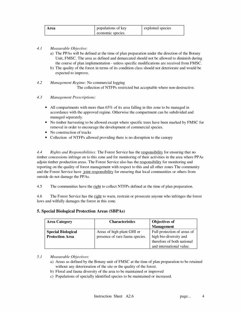
Special Biological Protection Area Areas of high plant GHI or presence of rare fauna
species.
Full protection of areas of high bio--
diversity and therefore of both national
and international value.
Botanical surveys undertaken by FMSC.
Cultural sites Culturally important areas identified during the
settlement procedure or in special cases areas
identified since and archaeological sites.
Preservation of the sites of traditional or
historic value for the benefit of the local
community and the nation.. Promotion
of tourism where acceptable.
As demarcated on existing base maps and re-
inforced by local knowledge during community
discussions.
Research Area Research Working Circles Provide scientific and technical
knowledge of use both by the Forest
Service and the wider scientific
community
Demarcated and mapped by the research
organisation. Information to be combined by
FMSC
Fauna Protection Areas Areas identified by the Wildlife Department as being
critical to the preservation of the habitat required for
rare or important species.
Maintenance of natural habitat for
critical species.
Instruction Sheet A2.3 page....8
Table 2.3. 2 (continued) Forest Management Categories to be used for Forest Reserve Zonation
Area Category Characteristics Objectives of Management Mean of Identification
SEMI-PROTECTION
Fire Buffer Zones Intact areas surrounding ‘valuable’ forest in fire
prone areas
Provide a buffer from fire from outside
the reserve reaching valuable forest
considered to be fire-susceptible.
Areas to be recommended by Ecology Unit ,
FMSC and modified as appropriate following
field inspections
Shelterbelts Areas with a large boundary to area ratio which are
therefore particularly vulnerable.
Maintenance of forest cover and hence
restrict spread of fire and provide
continuing shelter for agricultural crops
Original areas demarcated as shelterbelts for
protection from desiccating winds. Located
from existing forest reserve maps.
Convalescence forest Forest which due to either the effects of past logging
or fire is now at stage where it can not be logged in
the present management cycle. A guide of 15m2
basal area or less is indicative in this case
Area left to regenerate until
commercially sized timber available for
felling
Satellite imagery or air photography, supported
by ground reconnaissance
PRODUCTION
NTFP Production Areas Areas identified by rights holders as important NTFP
collecting grounds which do not fall into the
protection designations.
Production of NTFPs for local and
commercial use
NTFP survey (FMSC) but extended and
modified by local knowledge
Timber Production Areas Healthy productive forest. >15m2/ha. basal area
which does not fall into protection, research or NTFP
area designation.
Sustainable timber production Residual areas on the zonation maps after the
other zones have been identified
Plantation area Existing stands of artificially regenerated areas Timber . pole and fuelwood production Satellite imagery supported by ground surveys
OTHERS
Conversion Areas where forest cover and regeneration is
minimal and might be suitable for conversion to
plantations. A guide of 5m2 basal area or less would
suggest this condition.
To act as a land bank for possible
conversion to forest plantations if site
conditions are suitable.
Satellite imagery, forest inventory data and
ground reconnaissance.
Enclosed Farms Farmland which has been legally recognised. Legitimate agricultural practices which
do not lead to further forest damage
Existing forest boundary maps.
Instruction Sheet A2.3 page....9
THE STAR SYSTEM AND GENETIC HEAT INDEX
Tree species have been categorised on the basis of their scarcity and
the degree of exploitation. The different categories are referred to as
various star colours, i.e.
BLACK Rare internationally and uncommon in Ghana, highly
protected
GOLD Fairly rare both internationally and/or in Ghana, high
protection
BLUE Widespread internationally but rare in Ghana or vice versa.
Protection required
SCARLET Common, but under high pressure from over-exploitation.
Strict controls on annual allowable cut if they are to remain
commercially viable. Level of cut > 200% of AAC
RED Common, but tend to be over-exploited, restriction needed
Level of cut 100-200% of AAC
PINK Utilisable but not as popular to the trade,
present cut below AAC
GREEN No particular conservation concern
GENETIC HEAT INDEX (GHI): Used to provide a measure of the genetic
value of forest in terms of the composition of tree species only. It is a
weighted index derived from :-
GHI = (BKx27)+(GDx9)+(BUx3)+(RDx1)x100
BK+GD+BU+RD+GN
where BK= no. of black species, GD= gold species, BU = blue, RD = red
and GN = green.
Values range from 0 - 533
ECONOMIC INDEX (EI): Similar to the GHI but gives an indication of the
number of economic species, weights are the same as for the GHI.
Values range from 0 - 120
Instruction Sheet A2.4 page... 1
Manual of Procedures - Forest Resource Management in the HFZ
MOP Section A - Strategic Planning
A2. Forest Reserve Management Plans
Instruction Sheet A2.4 Provisional Setting of objectives for beneficiary
rights
Introduction
1.1 The resource owning communities have a statutory right to benefit for the management of the
forest reserves. These rights are guaranteed under the 1994 Forest and Wildlife Policy, the 1998 forest
Act and the 1992 Constitution.
1.2 All forest reserve management plans must clearly identify the local beneficiaries of reserve
management and the benefits they will receive from forest reserve management. This Instruction Sheet
prescribes procedures for identifying the beneficiaries and defining provisional beneficiary objectives.
Both the beneficiaries and the objectives will be finalised after the field investigations and formal
consultations.
1.3 The Forest Department is incorporating a collaborative forest management approach into all
aspects of forest reserve management in order to ensure local people can benefit for reserve
management and can contribute to improved forest reserve management. Equitable sharing of benefits
from reserve management is a key element of collaboration. Refer to the Guidelines on Collaboration in
Forest Reserve Management for details.
2. Provisional Identification the Beneficiaries of Forest Reserve Management
2.1 From previous records the ownership of the reserve should be determined and later verified in
consultation with traditional and local government authorities.
2.2 There are generally three types of owners of forest reserves:-
• Stool(s) or skin(s)
• The Government
• Alienation Holders
2.3 A provisional list of the communities that fall under the jurisdiction of the various types listed
above should be compiled during the reconnaissance visits (Instruction Sheet 2.5).
2.4 According to the 1992 Constitution, the revenue from stool land will be shared between the
Traditional Authority, the Stool and the District Assembly. The names of the concerned District
Assemblies and the Traditional Authorities should also be recorded.
Instruction Sheet A2.4 page... 2
INFORMATION BOX: BENEFITS TO LOCAL PEOPLE
The forest reserves have remained the property of their traditional owners, in addition to the indirect benefits associated with environmental protection, the direct benefits the owners should receive from forest
reserve management are:
• Revenue from natural forest management and plantation development on their land in accordance with the Constitution
• Secure access to forest products for domestic use free of charge and within the limits of sustainability
These benefits of forest reserve management are rights deriving from ownership and are not contingent on a further economic contribution to day to day forest management. The resource owning communities also have a right to be consulted during strategic planning.
Who are the local people ? Primarily the communities that own the land; all the communities that make up the land-owning stool will be identified in the management plan. In addition it is expected that settler communities accepted onto the land by the landowners and living close to the reserve will also be considered beneficiary communities. It is also envisaged that forest reserve management will become more efficient once collaboration is built into strategic planning and forest operations. Some communities have a comparative advantage in NTFP management, rehabilitation of degraded areas and fire prevention. Where it is agreed that a particular community is best placed to undertake certain operations a formal working partnership can be entered into.
3. Beneficiary Objectives: the right to revenue
3.1 The resource owners have a statutory right to receive all the revenue from forest reserve
management, less any revenue retained by the Forest Service as management fees for operations it is
agreed that the Forest Service will carry out.
3.2 The right of the beneficiaries to receive revenue from the forest reserve management should be
clearly stated as an objective of management.
3.3 During management planning the potential sources of revenue will be identified.
Instruction Sheet A2.4 page... 3
Beneficiary
Objective
Characteristic
s
Objective of
Management
Means of
Identification
Revenue from
forest reserve
management
Applies to all
production and
protection zones
To ensure a fair share of the
revenue is disbursed to the
landowners in accordance
with the provisions of the
Constitution and forest laws
in a timely fashion
Identify the resource
owners form the
previous management
plan and the gazette.
4. Beneficiary Objectives: The Rights to Forest Produce for Domestic Use
4.1 Local people have a statutory right to collect forest produce from the forest reserve to help
meet their requirements for forest produce for domestic use.
4.2 The management plan should clearly state that as an objective, the reserve will be managed to
provide forest produce to meet domestic needs.
4.3 During management planning the type of forest produce to be provided for domestic use should
be agreed.
Beneficiary
Right
Characteristics Objective of
Management
Means of
Identification
Access to forest
produce for
domestic use
Applies to all production
and protection zones
except SBPAs and
Fauna Protection Areas.
Restrictions on the
method of collection will
apply to some of the
management zones
To ensure local
people have access to
forest produce from
the forest reserve for
domestic use within
the limits of
sustainability
Field investigations to
identify all communities
that should use the
rights; plus review of
customary rights.
4.4 The communities also have the right to be consulted during reserve planning and in the
formulation of timber harvesting agreements, and may wish to establish specific operating restrictions
to be agreed by all parties.
4.5 The communities may wish to apply their own traditional controls on the method of collection
of NTFPs - restriction on the number of pestles per family/year, hunting restricted to set months etc.
As much as possible these traditions should be supported and incorporated within the agreed
management prescriptions for the zones. Reference should be made to the Guidelines on NTFP
management to be issued by the Community Forestry Management Unit of FMSC.
4.6 Specific Timber Operating Specifications may apply to timber contracts issued within the
reserves to take account of any local requirements and restrictions that need to be adhered to in order
to protect the environment or to protect community rights and traditions from infringement by would-
be contractors. (This is discussed in MoP C)
5. Additional Beneficiary Rights
Instruction Sheet A2.4 page... 4
5.1 Any additional beneficiary rights the local people may have been granted at the time of
reservation which are to be maintained or any new rights should be recorded in the objectives of
management.
5.2 Examples of the additional beneficiary rights may include right to employment on plantation
development programmes and rights of access to fetish sites and intellectual property rights.
Instruction Sheet A2.5 page... 1
Manual of Procedures - Forest Resource Management in the HFZ
MOP Section A - Strategic Planning
A 2. Forest Reserve Management Plans
Instruction Sheet A2.5 Supportive Field Investigations
1. Introduction
1.1 This instruction sheet provides guidance on the type of field investigations that will be required
in order to complete Part 1 of the management plan and by inference Part 2. The amount of field work
required will vary widely, depending on the number of communities dependent on the reserve and the
complexity of the area with respect to different potential management zones. In addition, the amount of
disturbance there has been since the last inventory will dictate the amount of re-assessment there will
need to be.
1.2 The types of survey that will be required:-
• socio-economic surveys of forest-user groups
• reconnaissance of forest types and comparison to the draft Forest Classification Map
• confirmation of the extent of convalescence areas and suitability for regeneration
• state of external and internal boundaries
• check on the condition of plantations compared to compartment records and maps
1.3 For those reserves where the earlier inventories were insufficient to provide an adequate
assessment of the forest, or there has clearly been major changes, then more intensive sampling might
be necessary than can be provided by reconnaissance surveys.
2. Socio-economic Investigations
Purpose of the Surveys
2.1 The socio-economic investigations aim to:-
• Identify those communities that will enjoy domestic use rights
• Understand the socio-economic context of reserve management
• Ensure all communities around the reserve are aware of the planning process and are able to
participate fully.
• Explore the potential for local collaboration in management.
Team Composition
2.2 Teams of three are recommended able to operate independently. It is expected that local
contracts will be given for this work as it will require intensive field work and would be outside the
normal operational functions of he Forest Service. It is expected that following training from the
FMSC, contracts can be given to a local field teams for this work . Redeployed extension agents living
in the area or local unemployed graduates can be effectively trained to carry out these tasks in their own
communities.
2.3 The team will be under the direction of the Regional Forest Planning Office and more directly
the DFO who would ensure that that they are familiar with the reserve and the communities.
Instruction Sheet A2.5 page... 2
Methodology
2.4 As far as possible, participatory approaches will be used to help the planning team gain an
understanding of the local socio-economic situation and to ensure local communities are involved in the
planning process. General guidance on survey technology can be found in the Guidelines of
Collaboration in forest Reserve Management prepared by the FMSC. Based on the findings of the
reconnaissance survey, the FMSC will assist in the design of surveys for a particular reserve and
provide training for local field teams.
2.5 The local field teams will use participatory tools to ensure that all the communities that live
around the reserve are contacted and all the key interest groups concerned with the management,
protection and use of the resource are identified and their particular needs, perceptions and ideas
understood.
2.6 The surveys will be designed to provide information on the following aspects:-
• social and economic structure of the communities
• perceived land and forest rights and relationship with other communities
• potential for collaboration in forest management operations
• dependence on the forest for products and services.
• the variety and scale of importance of timber and NTFPs
• indigenous knowledge of local ecology that may help to develop prescriptions for forest reserve
management
• any particular locations of importance for harvesting such materials
• experience of improving the propagation or directly improving the production of NTFPs
• calendar for harvesting and marketing
• the marketing chain and possibilities for local value added processing
• relationship with the former Forest Department and contractors
• issues likely to be important in defining Social Responsibility Agreements with contractors
• experiences of forest fire, location and reasons for regular burns
• interest in tree planting and providing contract labour
Reporting and Analysis
2.7 The reporting format will be defined by FMSC. As much of the basic data analysis will be
done by the teams themselves as part of the contract but inevitably some of this responsibility will fall
on the Regional Planning Office with support from FMSC.
2.8 The reports will be prepared on a reserve by reserve basis and will need to be supported by a
large scale map (1:25,000 approx.) to indicate the location of all communities interviewed, their
perceived area of interest, location of important NTFP harvesting sites and culturally significant areas
which should be removed form the timber production areas
Instruction Sheet A2.5 page... 3
3. Reconnaissance of the state of the high forest
Forest Classification
3.1 On receipt of the Provisional Forest Classification Map from FMSC, the DFO should organise
a field check to ascertain if the categories would appear to be correct making use of existing access
tracks. In some reserves, access might be such that one or several survey lines have to be cut. They
should be aligned to cross a range of the identified forest types . For this exercise the DFO might need
to obtain an enlargement of the forest classification map from FMSC. The map provided should be
overlain on the Survey of Ghana contoured map to assist location in the forest. The teams will need to
COLLABORATION IN FOREST RESERVE
MANAGEMENT
Collaboration is a working partnership between the local
people and the Forest Service to ensure that a management of
all forest resources is equitable and more efficient.
In order to ensure forest reserve management is equitable, the
management plan will clearly state the benefits the local
people have a right to receive from the management of their
resource.
Many communities living close to the reserve will also have a
comparative advantage in carrying out some of the
prescriptions for management of production and protection
zones. Communities may be able to collaborate in:
• establishment of plantations in conversion zones
• rehabilitation through enrichment planting in
convalescence zones
• establishment of fire breaks
• cultivation of NTFPS
• boundary maintenance
• research programmes
During the socio-economic surveys the potential for
collaboration should be explored. At a later stage agreements
can be drawn up to guide the implementation of collaborative
management programmes. The agreements will clearly specify
the objectives of the programme, activities, resources and
respective roles and responsibilities.
The practice of requesting some communities to freely
contribute their labour in order to obtain access to the reserve
to exercise their statutory right to collect NTFPs will cease.
Instruction Sheet A2.5 page... 4
select easily identifiable points for the start of the transect and carefully scaling off the distance to walk
before meeting an assumed change in forest classification.
3.2 It is hoped that more use can be made of a Global Positioning System (GPS) receiver for this
type of investigation since it allows the teams to accurately locate their position on a map without the
need for surveying.
3.3 The reconnaissance should be confirming that the condition classes indicted in FROGGIE are
correct, that the TSP summaries of basal area are acceptable for the areas visited and that the break in
slope for the start of the Hill Sanctuaries appears to have been properly located. In addition the
location of the convalescence zone should be checked and confirmation made that the level of
regeneration is adequate for the area to be retained for re-establishment under natural regeneration. The
guide of 5m2 per ha for the basal area for defining possible conversion areas - is just that, a guide. The
amount of regeneration needs to be examined and an estimate made of the likely effects of complete
protection, if there are adequate signs that the site might recover, then it should be left under
convalescence. The status of a particular piece of land can always be reviewed and down-graded for
potential conversion to plantations at a future date.
3.4 Land that is recognised as belonging to the conversion category, may in fact not be suited to
plantation development either because of undesirable site factors - shallow soil, low base exchange; or
indeed from a marketing point of view. i.e. poor access, distance from processing units etc. The use of
such land would need to be reviewed. Assistance will be provided by the MoP A on Plantation
Planning in this respect.
CONVALESENCE AND CONVERSION
AREAS
Areas where the basal area is consistently below
15m2/ha should be considered for convalescence and
taken out of the present series of coupes. Such areas may need active assistance through intensive fire
control and enrichment planting where regeneration is inadequate. Where elephant grass or Chromolaena is common then attention to fire control and enrichment planting will be essential. For those areas where the basal area is consistently below 5 m
2/ha may be considered as possible
conversion areas (i.e. plantation development areas). But first there needs to be an examination of the level of natural regeneration through regeneration counts. If there are good signs of natural regeneration taking place - then the area should be retained for convalescence. The chances of good regeneration will be improved by adequate protection.
Instruction Sheet A2.5 page... 5
Boundaries
3.5 During this reconnaissance stage the field staff should be examining the state of the external
boundaries of the reserve including the number of remaining pillars. Maintenance of clear boundaries is
a first step in forest protection. Encroachment and the spread of fire will be a natural consequence for
neglecting this task. At the same time internal boundaries - compartment boundaries, fire lines etc.
should be examined along with the state of roads and bridges.
3.6 Details of the work needed to put boundaries and roads into order is part of operational
planning, but there may be strategic decisions to be taken; for example, a reserve which is subject to
constant encroachment and/or fire on one perimeter may need a specific long term strategy
(development of buffer zones, improved community land management ) to address the problem.
Plantations
3.7 The extent of existing plantations are not always well known, though the recent national
inventory has provided detailed compartment maps for those areas sampled. The DFO will be provided
with copies of these maps modified where possible by recent satellite imagery. As part of the
preparatory phase for the management plan preparation, these base maps should be checked. As part
of the exercise, the field staff should check the status of the compartment registers and see if they
provide an up to date account of the operations carried out and the state of the present crop.
Observations should be made on the crop - whether it has failed or is potentially productive and the
approximate mean top height and its stocking. Note should also be made whether there would appear
to be any major changes since the time of the inventory, for example logging - or an extensive fire.
3.8 At this stage, a full plantation inventory is not needed, but a good estimate of the condition of
the resource is required. For small plantation areas, the DFO might indeed consider putting in
temporary sample plots in accordance with the procedures in instruction sheet A2 of the Plantations
MoP.
Instruction Sheet A2.6 page... 1
Manual of Procedures - Forest Resource Management in the HFZ
MOP Section A - Strategic Planning
A 2. Forest Reserve Management Plans
Instruction Sheet A2.6 Provisional management planning for protection zones
Management planning: an overview
For each management zone that has been identified long term management planning can now begin.
During management planning we are trying to prepare four things:
Measurable Objectives: For each zone a measurable objective is prepared to ensure progress
and performance can be monitored. The objective should cover
quality, quantity and time where applicable.
Management Regimes: The regime stipulates the general method of treatment for this
management zone. The regime is the same across the high forest zone
and is non-negotiable. In particular the regime stipulates whether or
not logging is permitted.
Management Prescriptions: The prescriptions recommend in more detail the silvicultural and other
operations required in this zone to achieve the objective. The
prescriptions are based on an understanding of the local situation and
can include suggestions on local collaboration in operations. Reference
must be made to specific MoPs.
Rights and Responsibilities: Specify who has rights in this management zone and who has
responsibilities
1. Introduction
1.1 This Instruction Sheet deals with the management planning relevant to the protection zones. -
both those under full protection and those regarded as being semi-protected. It defines the management
regimes that are appropriate to each zone. These have national relevance and therefore the main aspects
of the regimes are not open to negotiation. Minor modifications to some of the fringe aspects of the
regimes may be possible and these are indicated in the instructions.
1.2 The other components namely the measurable objectives, management prescriptions and rights
and responsibilities will be affected by local conditions. Guidance is provided on how to complete these
sections.
Protected Areas 2. Hill Sanctuary
Area Category Characteristics Objectives of Management
Hill Sanctuaries
All land within the reserve
where the slope is > = 30%,.
To provide environmental protection of
steep slopes that would be subject to
erosion if logged.
To ensure maintenance of the
watersheds.
Additionally provides an extensive area
of protection for undefined species of
both flora and fauna
Instruction Sheet A2.6 page... 2
2.1 Measurable Objective: The area of the Hill Sanctuaries will be defined and should become
practice immediately after the commencement of plan implementation. The objectives should therefore
define that the total area of...........ha as identified on the base maps will be retained in this zone, and
that the area will not be allowed to diminish during the management of the reserve. Furthermore, the
quality of the forest ( in terms of canopy closure or forest condition) will not be allowed to deteriorate,
and the construction of any new access tracks will be prevented. Additional isolated areas of Hill
Sanctuary will be defined as part of fine grained protection mapping.
2.2 An important objective of the Hill Sanctuaries is the maintenance of water supplies in terms of
quality (silt-levels) and quantity. For those reserves where this function is seen as critical, then regular
assessments should be implemented with the assistance of the water authorities.
2.3 Management Regime:
• No logging allowed throughout this zone.
• NTFPs can be collected following general Forest Service and Wildlife Department
Guidelines- providing this does not entail either:-
- tree felling
- construction of tracks for extraction
Local Modifications - Communities should be encouraged to define the scale and type of
NTFPs to be collected in these areas and define any appropriate restrictions in order to prevent
overcutting by a few individuals
2.4 Management Prescriptions:
• All compartments with more than 65% of their area falling in this zone are to be managed in
accordance with the approved regime. Otherwise, the compartment may be subdivided and
managed separately.
• No trees to be felled, but the collection of dead, fallen wood for local fuel requirement s is
permissible.
• All other harvesting restricted to NTFPs
• Any site specific restrictions on hunting to be prescribed by the Wildlife Department and
negotiated with the land owners during the preparation phase.
• Fire breaks of minimum 3 m and preferably 5 m to be established and maintained where this
zone borders with convalescence areas, conversion areas or farms in all Moist Semi-
deciduous and Dry Semi-deciduous reserves, plus other areas rated as having a high fire
risk.
2.5 Rights and Responsibilities: The Forest Service has the responsibility for ensuring that no
timber concessions infringe on to this zone and for monitoring their activities in the area where Hill
Sanctuaries adjoin timber production areas. The Forest Service also has the responsibility for
monitoring and reporting on the quality of forest management with respect to this and all other zones.
The community and the Forest Service have joint responsibility for ensuring that fire is not allowed to
enter the sanctuaries.
2.6 The communities have the right to collect fuelwood from dead trees for personal consumption
and for the collection of NTFPS in accordance with any self-imposed restrictions and in such a manner
that the state of the forest is not damaged. They are allowed free access at all times.
2.7 The Forest Service has the right to warn, restrain or prosecute anyone who infringes the forest
laws and wilfully damages the forest in this zone.
3. Swamp Sanctuaries
Instruction Sheet A2.6 page... 3
Area Category Characteristics Objectives of Management
Swamp
sanctuaries
Perennial wet
areas
Maintenance of water sources,
flora and fauna preservation
3.1 Measurable Objective: The area of Swamp will be defined through large-grained protection
mapping coupled with fine- grained protection mapping during stock surveying. The larger areas of
permanent swamp will therefore be clearly defined at the time the plan is under initial preparation. The
objectives should therefore state that the total area of...........ha as defined from the base maps will be
retained in this zone and the area will not be allowed to be disturbed by timber operators.
Furthermore, the area within this zone will for most reserves increase as the smaller swamp areas are
identified at the time of compartment inspection.
3.2 Management Regime: No logging allowed throughout this zone.
The collection of NTFPs prohibited or severely restricted
Hunting and the collection of fauna restricted
Local Modifications -Large swamps may be a traditional source of reeds, fish etc. Agreements
should be made on the level of access to these areas and the controls to be imposed.
3.3 Management Prescriptions:
• All compartments with more than 65% of its area falling into this zone to be managed in
accordance with the approved regime. Otherwise the compartment can be subdivided and
managed separately.
• No timber harvesting to be allowed
• No construction of tracks
• No collection of NTFPs except for those covered under local agreements made between the
Forest Service and the land owners at the time of the plan preparation.
3.4 Rights and Responsibilities: The Forest Service has the responsibility for ensuring that no
timber concessions infringe on to this zone and for monitoring of their activities in the area where
Swamp Sanctuaries adjoin timber production areas. The Forest Service also has the responsibility for
monitoring and reporting on the quality of forest management with respect to this and all other zones
The community and the Forest Service have joint responsibility for ensuring that local communities or
others from outside do not damage the sanctuaries.
3.5 The communities have the right to collect only those products defined at the time of plan
preparation.
3.6 The Forest Service has the rights to warn, restrain or prosecute anyone who infringes the forest
laws and wilfully damages the forest in this zone.
4. Provenance Protection Areas (PPAs)
Area Category Characteristics Objectives of
Management
Provenance Protection Area with high Act as gene banks for
Instruction Sheet A2.6 page... 4
Area populations of key
economic species.
exploited species
4.1 Measurable Objective:
a) The PPAs will be defined at the time of plan preparation under the direction of the Botany
Unit, FMSC. The area as defined and demarcated should not be allowed to diminish during
the course of plan implementation - unless specific modifications are received from FMSC.
b) The quality of the forest in terms of its condition class should not deteriorate and would be
expected to improve.
4.2 Management Regime: No commercial logging
The collection of NTFPs restricted but acceptable where non-destructive.
4.3 Management Prescriptions:
• All compartments with more than 65% of its area falling in this zone to be managed in
accordance with the approved regime. Otherwise the compartment can be subdivided and
managed separately.
• No timber harvesting to be allowed except where specific trees have been marked by FMSC for
removal in order to encourage the development of commercial species.
• No construction of tracks
• Collection of NTFPs allowed providing there is no disruption to the canopy
4.4 Rights and Responsibilities: The Forest Service has the responsibility for ensuring that no
timber concessions infringe on to this zone and for monitoring of their activities in the area where PPAs
adjoin timber production areas. The Forest Service also has the responsibility for monitoring and
reporting on the quality of forest management with respect to this and all other zones The community
and the Forest Service have joint responsibility for ensuring that local communities or others from
outside do not damage the PPAs.
4.5 The communities have the right to collect NTFPs defined at the time of plan preparation.
4.6 The Forest Service has the right to warn, restrain or prosecute anyone who infringes the forest
laws and wilfully damages the forest in this zone.
5. Special Biological Protection Areas (SBPAs)
Area Category Characteristics Objectives of
Management
Special Biological
Protection Area
Areas of high plant GHI or
presence of rare fauna species.
Full protection of areas of
high bio-diversity and
therefore of both national
and international value.
5.1 Measurable Objectives:
a) Areas as defined by the Botany unit of FMSC at the time of plan preparation to be retained
without any deterioration of the site or the quality of the forest.
b) Floral and fauna diversity of the area to be maintained or improved
c) Populations of specially identified species to be maintained or increased.
Instruction Sheet A2.6 page... 5
5.2 Management Regime: No tree felling
The collection of all NTFPs not allowed
Local Modifications -For very large SBPAs, a buffer zone may be recognised where the
selective collection of NTFPs will be allowed. A central core being retained for complete
protection.
5.3 Management Prescriptions:
• All compartments with more than 50% of its area falling in this zone to be managed in
accordance with the approved regime. Otherwise the compartment can be subdivided and
managed separately.
• No logging of any type to be allowed within the SPBAs (including buffer zones)
• No construction of tracks
• Collection of NTFPs not allowed, limited collection may be possible within the buffer
zones if these have been demarcated as such . Collection within the core area always
forbidden.
5.4 Rights and Responsibilities: The Forest Service has the responsibility for ensuring that no
timber concessions infringe on to this zone and for monitoring of their activities in the area where
SBPAs adjoin other zones. The Forest Service also has the responsibility for monitoring and reporting
on the quality of forest management with respect to this and all other zones The community and the
Forest Service have joint responsibility for ensuring that local communities or others from outside do
not enter the SBPAs. In areas protected in the interest of the globally significant biodiversity, the Forest
Service is responsible for trying to secure compensatory grants or funding for alternative livelihood
support wherever possible.
5.5 The communities have a restricted right to collect specified NTFPs within the buffer zones but
not within the core zone. The range of NTFPs and the location of the buffer zone to be agreed at the
time of plan preparation.
5.6 The Forest Service has the right to warn, restrain or prosecute anyone who infringes the forest
laws and wilfully damages the forest in this zone.
6. Cultural Sites
Area Category Characteristics Objectives of Management
Cultural sites and
Tourist
Development
Areas
Culturally important areas
identified during the gazettment
procedure or following local
consultation process. May be
both national archaeological
sites and those relating to local
traditions
Preservation of the sites of
traditional or historic value
for the benefit of the local
community and the nation.
Encouragement of tourism
when appropriate and agreed
by the communities
6.1 Measurement Objectives: Preservation of the site. No damage to be caused to the area through
the collection of timber or NTFPs.
6.2 Management Regime: complete protection from forest activities.
6.3 Management Prescriptions:
Instruction Sheet A2.6 page... 6
• All compartments with more than 65% of its area falling in this zone to be managed in
accordance with the approved regime. Otherwise the compartment can be subdivided and
managed separately.
• No logging of any type to be allowed within cultural sites
• No construction of tracks
• Collection of NTFPs not allowed, unless communities request specific products (non-
destructive collection techniques) acceptable within local traditions.
6.4 Rights and Responsibilities: The Forest Service has the responsibility for ensuring that no
timber concessions infringe on to this zone and for monitoring of their activities in the area where
cultural areas adjoin other zones. The Forest Service also has the responsibility for monitoring and
reporting on the quality of forest management with respect to this and all other zones The community
and the Forest Service have joint responsibility for ensuring that local communities or others do not
damage these sites.
6.5 The communities may have a very restricted right to collect specified NTFPs. The range of
NTFPs to be agreed at the time of plan preparation.
6.6 The Forest Service has the right to warn, restrain or prosecute anyone who infringes the forest
laws and wilfully damages the site.
7. Research Areas
Area Category Characteristics Objectives of Management
Research Area Research Working Circles Provide scientific and technical
knowledge of use both by the
Forest Service and the wider
scientific community
7.1 Measurable Objectives: Site to be managed in accordance with the treatments defined in the
research plan.
No undesired external treatment allowed to affect the forest.
7.2 Management Regime: Defined by the research organisation..
7.3 Management Prescriptions:
• All compartments with more than 75% of its area falling in this zone to be managed in
accordance with the approved regime. Otherwise the compartment can be subdivided and
managed separately.
• No logging of any type to be allowed within research sites, unless specified within the research
plan.
• No construction of tracks, unless specified in the research plan
• Collection of NTFPs not allowed, unless specific instructions to the contrary are provided by
the research organisation.
7.4 Rights and Responsibilities: The Forest Service has the responsibility for ensuring that no
timber concessions infringe into research sites, unless standard logging is acceptable to the researchers.
The Forest Service also has the responsibility for monitoring and reporting on the quality of forest
management with respect to this and all other zones The Forest Service will monitor timber extraction
where activities are close to research plots. The community and the Forest Service have joint
responsibility for ensuring that local communities or others do not damage these plots.
Instruction Sheet A2.6 page... 7
The Forest Service has the right to warn, restrain or prosecute anyone who infringes the forest laws
and wilfully damages the plots.
8. Fauna Protection Areas (FPAs)
Area Category Characteristics Objectives of Management
Fauna Protection
Areas
Areas identified by the Wildlife
Department as being critical to the
preservation of the habitat required
for rare or important species.
Maintenance of natural
habitat for critical species.
8.1 Measurable Objectives:
a) Areas as defined by the Wildlife Department at the time of plan preparation to be retained
without any deterioration of the site or the quality of the forest.
b) Floral and fauna diversity of the area to be maintained or improved
c) Populations of specially identified species to be maintained or increased.
8.2 Management Regime: No tree felling
The collection of all NTFPs not allowed
No road or track development
Local Modifications -For very large FPAs, a buffer zone may be recognised where the
selective collection of NTFPs will be allowed. A central core being retained for complete
protection.
8.3 Management Prescriptions:
• All compartments with more than 50% of its area falling in this zone to be managed in
accordance with the approved regime. Otherwise the compartment can be subdivided and
managed separately.
• No logging of any type to be allowed within the FPAs (including buffer zones)
• No construction of tracks
• Collection of NTFPs not allowed, limited collection may be possible within the buffer zones if
these have been demarcated as such . Collection within the core area always forbidden.
8.4 Rights and Responsibilities: The Wildlife Department and the Forest Service have the
responsibility for ensuring that no timber concessions infringe on to this zone and for monitoring of
their activities in the area where FPAs adjoin other zones. The Forest Service also has the
responsibility for monitoring and reporting on the quality of forest management with respect to this and
all other zones The community and the Forest Service have joint responsibility for ensuring that local
communities or others from outside do not enter the FPAs
8.5 The communities have a restricted right to collect specified NTFPs within the buffer zones but
not within the core zone. The range of NTFPs and the location of the buffer zone to be agreed at the
time of plan preparation.
8.6 The Forest Service has the right to warn, restrain or prosecute anyone who infringes the forest
laws and wilfully damages the forest in this zone.
Semi-Protected Areas
9. Fire Buffer Zones
Area Category Characteristics Objectives of Management
Instruction Sheet A2.6 page... 8
Fire Buffer Zones Intact areas
surrounding
‘valuable’ forest in
fire prone areas
Provide a buffer from fire from outside
the reserve reaching valuable forest
considered to be fire-susceptible.
9.1 Measurable Objectives:
a) Forest areas that are identified as Fire Buffer Zones by the Ecology Unit of FMSC at the
time of plan preparation to be retained and successfully prevented from further logging.
b) Ground cover maintained in semi-green state due to maintenance of closed forest conditions
c) Forest fires peter out before crossing the buffer
9.2 Management Regime: No tree felling
The collection of all NTFPs allowed providing harvesting is non-destructive to
the forest.
9.3 Management Prescriptions:
• All compartments with more than 50% of its area falling in this zone to be managed in
accordance with the approved regime. Otherwise the compartment can be subdivided and
managed separately.
• No logging of any type to be allowed within the fire buffer zones
• No construction of tracks
• Collection of NTFPs allowed where the collection does not damage the forest
• Early burning along the outer edge of the buffer
• Additional fire line to be maintained along the inside edge of the buffer
9.4 Rights and Responsibilities: The Forest Service has the responsibility for ensuring that no
timber concessions infringe on to this zone. The community and the Forest Service have joint
responsibility for ensuring that local communities or others from outside do not log within the buffer
zones. The Forest Service also has the responsibility for monitoring and reporting on the quality of
forest management with respect to this and all other zones
9.5 The communities have a restricted right to collect specified NTFPs within the fire buffer
zones The range of NTFPs to be agreed at the time of plan preparation.
9.6 The Forest Service has the right to warn, restrain or prosecute anyone who infringes the forest
laws and wilfully damages the forest in this zone.
10. Shelterbelts
Area Category Characteristics Objectives of Management
Shelterbelts Areas with a large boundary
to area ratio which are
therefore particularly
vulnerable.
Maintenance of forest cover
and hence restrict spread of fire
and provide continuing shelter
for agricultural crops
10.1 Measurable Objectives:
a) Areas that are identified as Fire Shelterbelts by the Ecology Unit of FMSC or by the DFO
at the time of plan preparation to be retained and successfully prevented from further
logging.
b) Ground cover maintained in semi-green state due to maintenance of closed forest conditions
c) Forest fires peter out before crossing the buffer
Instruction Sheet A2.6 page... 9
10.2 Management Regime: No felling of any live tress. no felling of any slightly burnt trees
The collection of all NTFPs allowed providing harvesting is non-destructive to
the forest.
10.3 Management Prescriptions:
• Compartments can not be subdivided - all compartments in narrow strips of forest within the
DS and MS zones to be included
• No logging of any type to be allowed within the shelterbelts
• No construction of tracks
• Collection of NTFPs allowed where the collection does not damage the forest
• Early burning along the outer edge of the buffer
• Additional fire line to be maintained along the inside edge of the sheltebelt
10.4 Rights and Responsibilities: The Forest Service has the responsibility for ensuring that no
timber concessions are allocated to these compartments. The Forest Service also has the responsibility
for monitoring and reporting on the quality of forest management with respect to this and all other
zones The community and the Forest Service have joint responsibility for ensuring that local
communities or others from outside do not log within the shelterbelts.
10.5 The communities have a restricted right to collect specified NTFPs within the shelterbelts.
The range of NTFPs to be agreed at the time of plan preparation.
10.6 The Forest Service has the right to warn, restrain or prosecute anyone who infringes the forest
laws and wilfully damages the forest in this zone.
11.Convalescence Forest
Area Category Characteristics Objectives of Management
Convalescence forest Forest which due to either the
effects of past logging or fire is
now at stage where it can not be
logged in the present management
cycle. A guide of 15m2 /ha basal
area or less is indicative in this
case
Area left to regenerate until
commercially sized timber
available for felling
11.1 Measurable Objective:
a) Areas as defined at the time of plan preparation are maintained are not logged for at least 40
years.
b) Regular improvement in the stocking of the forest over the convalescence period
11.2 Management Regime: No logging for at least 40 years
Intensive fire protection
Enrichment planting in selected areas
Collection of NTFPs restricted to herbs
11.3 Management Prescriptions:
• All compartments with more than 65% of its area falling in this zone to be managed in
accordance with the approved regime. Otherwise the compartment can be subdivided and
managed separately.
Instruction Sheet A2.6 page... 10
• No logging of any type to be allowed until the area reverts back to timber production
• Enrichment planting with suitable fast growing species planted into cut lines at intervals of
around 5-10 m intervals
• Maximum fire protection should be planned. The perimeter to be defined with clear fire lines.
For large areas, division by subsidiary fire breaks should be carried out.
• Collection of NTFPs allowed where the collection does not damage the forest
The status of the forest will be reviewed after 40 years to see if the areas can be brought into the
forthcoming rotation.
11.4 Rights and Responsibilities: The Forest Service has the responsibility for ensuring that no
timber concessions are allocated to these compartments. The Forest Service also has the responsibility
for monitoring and reporting on the quality of forest management with respect to this and all other
zones The community and the Forest Service have joint responsibility for ensuring that local
communities or others from outside do not attempt to log in these areas
11.5 The communities have a restricted right to collect specified NTFPs . The range of NTFPs to
be agreed at the time of plan preparation.
11.6 The Forest Service has the right to warn, restrain or prosecute anyone who infringes the forest
laws and wilfully damages the forest in this zone.
Instruction Sheet A2.7 page... 1
Manual of Procedures - Forest Resource Management in the HFZ
MOP Section A - Strategic Planning
A2. Forest Reserve Management Plans
Instruction Sheet A2.7 Provisional management planning for production zones
I. Introduction
1.1 This Instruction Sheet provides assistance on the management planning required for all the
production zones. The format is similar to that used for Instruction Sheet 2.6 (Protection Zones). For
all the zones, descriptions are provided for the main sub heads of Measurable Objectives, Management
Regimes, Management Prescriptions and Rights and Responsibilities as used in Sheet 2.6; however, an
additional heading of Indicative Levels of Production is also included.
1.2 There will be uniformity for many of these subheads across the country for any one particular
zone.
2. Timber Production Areas
Area Category Characteristics Objectives of
Management
Timber Production
Areas
Healthy productive forest.
>15m2/ha. basal area which does
not fall into a protection zone or
NTFP area designation.
Sustainable timber
production
2.1 Measurable Objectives: Sustainable production of timber to provide a perpetual flow of
wood products, revenue for the resource owners and to fund forest management while maintaining
environmental quality and social responsibility.
Timber production should be roughly equal each year and as the forest moves into normality the area of
forest logged each year should be close to 1/40 of the total area of the timber production area.
2.2 Management Regime:
The timber production areas will be managed using the selection system with fixed diameter limits for
each commercial species. The rotation has been set at 40 years for all forests. Yield is strictly
controlled using documented guidelines on tree selection and the application of defined yield formula..
2.3 Management Prescriptions:- summary
• definition of the timber production areas into compartments of around 100 -150 ha
• definition of harvesting schedules to define the most appropriate time to fell each compartment
linked to the identification of the extent of the Timber Utilisation Contract (TUC) area.
• Award of timber utilisation contracts
• 100% stock surveys of compartments scheduled for felling
yield calculation and yield approval and selection of trees to be extracted
Management Prescriptions - detailed
Formation of Compartments
Instruction Sheet A2.7 page... 2
2.4 In order to ensure adequate control over operations, it is necessary to subdivide the reserve
into compartments. For most reserves, compartments have already been identified (at least on paper)
for those areas identified as being outside the original Protection Working Circles as used in the first
management plans. Following re-zoning of the reserves it may be necessary to re-examine the layout of
the compartments. If changes have to be made the opportunity should be made to ensure that
boundaries follow natural features (streams, ridges, slope breaks etc.) as much as possible, to limit the
problems of identification in the forest.
2.5 The identification of compartments on a map should cover all forest zones. However, where
there are large contiguous blocks of Hill Sanctuaries, then compartment numbers are of less importance
in terms of the management plan. The mapping section of FMSC may need to prescribe compartment
numbers to all areas, however, for purposes of maintaining the map data base.
2.6 The standard compartment dimensions of 1 mile x 0.5 mile or 1,600 x 800 m approx.
(equivalent to 128 ha) does not need to be rigidly adhered to but a compartment size of 100-150 ha is of
the right order. Changing compartment boundaries for those reserves where there are already well
documented compartment records should be avoided because of the need to maintain a continuous
record of operations carried out within a particular area and to ensure that any one area is not re-
entered prior to the 40 year period. Compartments are demarcated by fixed pillar. Prior to harvesting
the boundary lines are cut.
Harvesting Scheduling
2.7 In order to adhere to the management regime of a 40 year felling cycle, it is necessary to
allocate each compartment within the timber production area into five year felling coupes to fit as
closely as possible to a forty year period between planned felling and the time of last entry. This
process is described in detail in the MoP Section E. In order for this process to be properly carried out
details of compartment history are needed and for this reason, the maintenance of a compartment
register is essential.
2.8 The area available and the age structure of the regeneration within the timber production area
of a single reserve will in many cases be insufficient to provide adequate timber for an economically
viable TUC . Even where the strategic management plan has been prepared for a Forest Management
Unit of total area (all zones) of around 500 km2 , the area available for timber production might still be
considered inadequate. In such circumstances re-grouping of reserves for purposes of timber production
may be necessary. For details on the process of operational planning for TUCs on reserve including the
award of the TUC contract, you are referred to MoP Section F.
Stock Surveys and Allocation of Yield.
2.9 The Forest Service has adopted a procedure of 100% stock surveys following the award of
TUCs. All commercial species of diameter in excess of 50 cm (and 30 cm for a few species) are
measured and recorded and their position noted on survey sheets. All Black Star species are recorded
(regardless of their size). The survey is used not only to record the position of potential harvestable
trees but to detail information required for the implementation of fine-grained protection rules, this
takes into account such matters as:-
• distribution of trees within the compartment
• condition of the forest canopy and understorey
• need to retain more trees in sensitive areas
• need to retain seed trees
• protection of 25m wide riparian strips
• slopes, swamps and rocky areas
• protection of any rare species
Instruction Sheet A2.7 page... 3
2.10 Strict rules set the number of trees that can be felled per ha and the total cut allowed for each
species is fixed by application of one of two yield formula (referred to as “standard” and “reduced”).
The process of stock surveys and yield allocation are the subject of MoP Section D. Yield approval is
given in the form of a felling permit which lists the stock survey number and species of all trees that can
be felled.
Indicative Level of Production
2.11 The plan should provide an indicative level of production expected from the timber production
zone, based on information derived from pre-exploitation inventories or from actual yields derived from
this reserve or an adjacent reserve where conditions are similar.
2.12 Assistance from FMSC may be required on this aspect, though the DFO will be supplied with
all relevant information taken from the national forest inventory plus any other subsequent studies as
part of the Part 1 exercise.
Rights and Responsibilities:
2.13 The following rights and responsibilities apply to this zone:-
a) The Forest Service has the responsibility for ensuring that the TUC is allocated only within the
timber production areas of the reserve and ensuring that the consultation process has been
correctly adhered to with respect to the preparation of the Timber Operational Specifications
and the Social Responsibility Agreements required under the TUC procedures.
b) The Forest Service has the responsibility for ensuring that the concessionaires adhere to the
regulations of the Logging Manual in all respects.
c) The Forest Service also has the responsibility for ensuring that all payments are collected on
behalf of the landowners and the Government and that accounts of all such receipts are
properly maintained for inspection .
d) The communities have the responsibility of adhering to the TUC and allowing unfettered access
to the site by the contractor, providing he has adhered to the contract. They have the joint
responsibility with the Forest Service and the contractor of controlling illegal logging,
encroachment and forest fire.
e) The contractor has the responsibility to respect the rights of the landowners and to ensure that
the all aspects of the contract are adhered to.
f) The communities have a restricted right to collect specified NTFPs . The range of NTFPs to
be agreed at the time of plan preparation.
g) The contractor has the right to access to the site and the removal of timber in accordance with
the terms of the contract and the procedures of the implementation of the TUC.
h) The Forest Service has the right to warn, restrain or prosecute anyone who infringes the forest
laws and wilfully damages the forest in this zone.
i) The Forest Service has the right to stop the operation of the contractor if he is seen to operating
in breach of the TUC agreement
3. NTFP Production Areas
Instruction Sheet A2.7 page... 4
Area Category Characteristics Objectives of Management
NTFP Production
Areas
Areas identified by rights holders
as important NTFP collecting
grounds which do not fall into the
protection designations.
Sustainable production of
NTFPs for local and
commercial use
Measurable Objectives:
3.1 Sustainable production of NTFPs (including bushmeat) for domestic use by local communities
and for meeting the demands of controlled commercial trading .
3.2 The type of NTFPs traditionally collected and traded by the local communities will have be
defined during the initial field investigations (refer Instruction Sheet 2.4) and the collection sites
identified. Although the collection of NTFPs will be a right for the local communities (with some
controls) in all the zones - with the exceptions of the SBPAs and the Fauna Protections Areas; this
zone defines special collection areas to be set aside where normal logging is excluded. In such areas a
measurable objective will be that the harvestable volume is maintained or increased, and that the
boundaries of the area are respected by other forest users.
3.4 Management Regime
No commercial logging. Selective felling to create light gaps to encourage the growth of selective
NTFPs permissible
3.5 Management Prescriptions
• All compartments with more than 65% of its area falling in this zone to be managed in
accordance with the approved regime. Otherwise the compartment can be subdivided and
managed separately.
• No commercial logging
• The selective opening the of canopy and removal of undergrowth to be undertaken in
accordance with the silvicultural requirements of the NTFPs being encouraged
• Propagation of NTFPs to be undertaken in suitable sites, but any extensive opening of the
tree canopy permissible only on a case by case basis.
• Hunting to be controlled through the issue of licences and agreed quotas
Indicative Level of Production
3.6 The plan should provide an indication of the level of production to be expected for any
commercially traded product. Figures will in most cases have to be based on historical trade figures
supported where possible by local knowledge on number of headloads etc. removed. The assistance of
the Community Forestry Management Unit in FMSC should be consulted for background information
on the standard production levels to be expected to assist in completing this section.
3.7 It is unlikely that the district team will feel that they have adequate information to differentiate
the target level of NTFP production from this zone from the expected production from all the other
zones where NTFP collection is acceptable practice. In most plans, the total production for the entire
reserve/FMU will be the best that can be achieved.
3.8 Rights and Responsibilities:
a) The Forest Service has the responsibility for ensuring that the NTFP Production Area is
excluded from the TUC area.
b) The communities have a responsibility for ensuring that no tree felling is undertaken without a
permit and no cultivation is undertaken except for the production of recognised NTFPs
Instruction Sheet A2.7 page... 5
c) The communities have a responsibility for ensuring that no fire is used for clearing
undergrowth and that any such work is only undertaken as part of an approved programme.
d) The communities have a responsibility for ensuring that all hunters are duly licensed and
adhere to self-managed quotas
e) The Forest Service has the right to warn, restrain or prosecute anyone who infringes the forest
laws and wilfully damages the forest in this zone.
f) The community have the right to keep the revenue generated from the sale of the NTFPs less
any royalty that has been defined within the plan.
4. Plantation Production Areas
Area Category Characteristics Objectives of Management
Plantation
Production area
Existing stands of
artificially regenerated areas
Income generation from timber
pole and fuelwood production
maximised in accordance with
professional forestry technical
and commercial principles
4.1 Measurable Objectives: Regular production of marketable produce providing a commercial
return on investment
4.2 Management Regime: Plantations established by use of seedling stock (rarely direct seeding)
and managed in accordance with well tested silvicultural principles specific to the particular species
using thinning at defined intervals to maximise production of material of commercially desirable
diameters.
4.3 Management Prescriptions- summary
• Plantation area divided into compartments of 50 ha approx.
• seedlings raised in nurseries as potted stock
• standard silvicultural regimes applied for:-
weeding
thinning
pruning
and the timing of final felling
method of crop replacement
• Extensive use of contract labour to undertake all operations
• Possible use of taungya principles for crop replacement and initial establishment
• Competitive bidding for sale of produce
• Competitive bidding for the incorporation of existing plantations into new plantation
development projects.
Management Prescriptions -detailed
Formation of Compartments
4.4 Compartments of approximately 20- 50 ha are to be used. Where this mean making use of the
standard natural forest compartment of 128 ha then it will be divided into four and numbered in
Instruction Sheet A2.7 page... 6
accordance with the old compartment number but with an additional suffix ( i.e. 48/1, 48/2 etc.).
Compartments should be pillared and the boundaries kept clean. (Refer Plantation MoP Section A)
4.5 A compartment register is required to be maintained providing information on the compartment
location and all activities undertaken and a 1:10,000 scale compartment map prepared.
Seed Production and Collection
4.6 Seed has been traditionally collected from locally identified seed stands or from standard stock.
this has led to the use of material of poor genotype and in the future the standard practice will be only
to use seed approved by FORIG for the plantations on-reserve
Forest Nurseries
4.8 Planting stock is raised as tubed stock using direct sowing into the polythene pots or tubes or
making use of separate germination beds where seed is known to demonstrate irregular germination.
Reference should be made to the Plantation MoP Section B.
Silvicultural Operations
4.9 Weeding is required until canopy closure. The prescribed treatment being clearance of the
planting lines for a width of 2 m as often as is required during the season (refer Plantation MoP Section
C). All weeding is by hand. In the future, where slope and site access permits, the selective use of
mechanical weeding will be necessary for large scale plantation development..
4.10 Silvicultural selective thinning is standard and prescribed thinning regimes are available for
teak, Cedrela/Ofram and Gmelina, (Plantation MoP Section C). Regimes for other species will be made
available from FORIG as required. Pruning in order to reduce knot incidence will be essential for the
final crop if international markets are being aimed for or the material is destined for peeling.
4.11 Past practice has been to make use of taungya for plantation establishment. This practice can
still be used for small areas and where old plantations are being replaced under the direction of the
Forest Service. However it is unlikely to be a standard practice where large scale plantation
development is being undertaken under commercial contracts.
Competitive Bidding
4.12 The use of competitive bidding and fixed contracts for thinning and other operations should be
considered the normal practice, since the Forest Service will not maintain a sufficient permanent labour
force to undertake such work. Local communities should be encouraged to bid to undertake such
operations in order to retain as much income as possible within the community.
Indicative Level of Production
4.13 The plan should provide an indicative level of production expected from the plantations, based
on the age structure and details of the stocking and standing volume provided by the recent national
inventory. This should be in a summary form covering a period of about 20 years if the DFO feels that
the data is adequate to show this. The level of planting or replanting would be indicated based on the
expected time of clear felling.
4.14 As an attachment to the strategic plan, there will be five year operational plans (refer MoP
Section B), in which as much detail as possible will be required on the level of activities and level of
production over the next five years.
Instruction Sheet A2.7 page... 7
4.15 Assistance from FMSC may be required on this aspect, though the DFO will be supplied with
all relevant information taken from the national forest inventory plus any other subsequent studies as
part of the Part 1 exercise.
4.17 Rights and Responsibilities:
a) The Forest Service has the responsibility for ensuring that the plantations are managed in a
commercially and technically responsible manner.
b) The Forest Service has the right to warn, restrain or prosecute anyone who infringes the forest
laws and wilfully damages the forest in this zone.
5. Conversion Areas
Area Category Characteristics Objectives of Management
Conversion
or Plantation
Development Area
Areas where forest cover
and regeneration is minimal
and might be suitable for
conversion to plantations.
A guide of 5m2 basal area
or less would suggest this
condition.
To restore tree cover on
severely degraded areas of the
forest reserve, through the
establishment of plantations, in
order to restore environmental
functions and to generate
revenue for the resource
owners.
5.1 Measurable Objectives: Degraded forest land restored to productive use through the
establishment of commercially viable plantations.
5.2 Management Regime: Land initially identified as supporting very degraded forest, confirmed to
be classified as condition class 6 and unsuitable for regeneration. It is set aside for plantation
development by the private sector
5.3 Management Prescriptions:
• Initially zonation from satellite imagery, supported by reconnaissance, to indicate extent of the
degraded area.
• More detailed surveys to confirm forest is generally condition class 6 and that the frequency of
regeneration is too low to be viable.
• All compartments with more than 65% of its area falling in this zone to be managed in accordance
with the approved regime. Otherwise the compartment can be subdivided and managed separately.
• Maps of the zone made available at appropriate scale (1:10,000 - 1,50,000) depending on extent,
and boundary descriptions prepared
• Private sector investment for an approved forestry plantation programme initiated
• Forest Service to undertake site assessment studies in order to assist private sector investors on
possible sites and growth potential.
• Would-be investors required to undertake feasibility studies and business development plan for
consideration.
• Would be investors required to undertake a full EIA and SIA
• Plantation developers enter into an agreement with the resource owners which specifies property
rights, social responsibilities and benefit-sharing arrangements.
• Plantation development undertaken under a fixed (long) term contract with guidelines on the
technical requirements expected from the Forest Service.
Instruction Sheet A2.7 page... 8
5.4 Indicative Level of Production: The plan should provide an indicative level of production
expected from the plantations development area, based on average production levels for key indicator
plantation species likely to be suited to the site. Assumptions will need to be made on the amount of
land likely to be found suitable for planting .
5.5 Rights and Responsibilities:
a) The Forest Service has the responsibility for ensuring that the land is put into useful
production as soon as possible.
b) The Forest Service has the responsibility of ensuring that the selection of the contractor is
carried out in fair and transparent manner and to the satisfaction of the land owners
c) The Forest Service has the responsibility of monitoring the programme and ensuring that all the
guidelines relating to quality of stock, silvicultural management and protection are fully
adhered to.
d) The successful contractor has the responsibility of developing the site in accordance with the
management proposal.
e) The contractor has the right to develop the site without interference providing all aspects of the
contract are adhered to.
f) The community has the right to be kept informed of the selection process for the contractors
and the reasons for selecting a particular candidate. The approval of the landowners will be
required before the contract can be issued.
g) The Forest Service has the right to warn, restrain or prosecute anyone who infringes the forest
laws and wilfully damages the forest in this zone.
Instruction Sheet A2.8 page... 1
Manual of Procedures - Forest Resource Management in the HFZ
MOP Section A - Strategic Planning
A2. Forest Reserve Management Plans
Instruction Sheet A2.8 Provisional management planning for local people
1. Introduction
1.1 This instruction sheet provides guidance on management planning for provision of benefits to
the local communities and the land owners.
2. Revenue From Forest Reserve Management
2.1 Management objective: To ensure that as owners of the reserve, the people of ............
shall receive the gross revenue arising from the utilisation of the forest reserve in accordance with this
management plan, less any deductions the Forest Service is authorised to make by law in order to carry
out its operations
2.2 Management regime:
Forest Service will collect all revenue on behalf of the owners and will disburse the revenue to the
Administrator of Stool Lands for onward distribution to the Stool, Traditional Authority and District
Assembly in a timely manner and in accordance with the 1992 Constitution.
2.3 Management prescription:
• Service agreement with forest owners to stipulate that the Forest Service will be required to
extract maximum market value from forest exploitation and make deductions for management
expenses only against activities that have been agreed in the management plan.
• Accounts on all transactions to be maintained and summarised on a monthly basis as part of
the standard monthly reporting procedure. A financial report to be prepared as part of the
annual report for each reserve/FMU (refer Instruction Sheet 2.11) each of which should be
made available to the public.
• All records of revenue disbursements to traditional authorities, stools and district assemblies
will be made public in order to ensure the members of the resource owning communities are
fully appraised of transactions being made on their behalf.
2.4 Indicative levels of revenue:
Forest Service should be able to make projections of the likely revenue flows in the period of the plan
based on the TUC agreements and historical levels of NTFP marketing.
2.6 Rights and responsibilities:
a) The Forest Service has the responsibility of ensuring that full records of all receipts and
expenditure are maintained and available for public scrutiny
b) The Forest Service has the responsibility for ensuring that all revenue owed to the land owners
is returned to them without delay on the basis of quarterly transfers
c) The Forest Service has the responsibility of presenting an annual financial statement as part of
the annual reporting programme. Such reports will be in the public domain
d) The land owners/communities have the right to request details of all transactions carried out on
their behalf.
Instruction Sheet A2.8 page... 2
e) The land owners/communities have the right to be informed of how the Forest Service has
made use of the management fees retained under the agreements
f) The resource owners have the right to sue the Forest Service for any failure to collect and
disburse revenue or for delays in forwarding revenue. The resource owners have the right to
receive interest on any late disbursements.
g) The Forest Service has the right to retain a fee for their services, providing it does not exceed
the stated terms of the agreements
3. Access To Forest Products
Domestic Use
3.1 Measurable objective: To maintain a perpetual flow of forest produce to communities with
domestic user rights in order to fulfil some of their household requirements for forest produce.
3.2 Management regime: Local communities identified as having domestic user rights will be
allowed free and unhindered access to the reserve to collect forest produce in accordance with the
harvesting rules agreed between representatives of all communities and the Forest Service.
3.3 Management prescriptions:
• Harvesting rules can be agreed for all management zones, however in the case of SBPAs
and Fauna Protection Areas there may be severe restrictions on the collection at least for the
core areas.
• Socio-economic assessment of the critically important NTFPs and other forest produce,
harvesting levels, traditional controls, marketing processes, scale of use within the
community, household needs assessment and level of export out of the area.
• Resource assessment of each critical NTFP
• Formulation of rules and agreements for harvesting of each NTFP on sustainable basis,
incorporating as much as possible the traditional practices and controls.
3.4 Indicative levels of production: The Forest Service should be able to stipulate the amount each
household can take based on the agreed rules and historical levels of collection.
3.5 Rights and Responsibilities: Specific rights and responsibilities will be defined in each domestic
use agreement. General provisions are:-
• The Forest Service has the responsibility of ensuring that surveys and negotiations required to
develop domestic use agreements are undertaken.
• The Forest Service has the responsibility of periodic monitoring of exploitation according to the
harvesting rules and periodic monitoring of the condition of the resource.
• The Forest Service has the responsibility of ensuring that no NTFPs are harvested by the TUC
holder and his employees and that TUC operations are sympathetic to NTFP production.
• The Forest Service has the responsibility of ensuring that all FS staff are aware of the agreed
domestic use rights.
• The FS has the responsibility to prosecute outsiders not in the possession of domestic use rights
who harvest forest produce unlawfully.
• All members of the communities with user rights have the responsibility for adhering to the rules
and for ensuring fellow members the community do so and that outsiders do not enter the reserve.
Instruction Sheet A2.8 page... 3
• The holders of domestic use rights have the right to harvest NTFPs unhindered and free of charge
as long as they adhere to the terms of the agreement.
• The holders have a right to be compensated for severe restrictions imposed in the interests of global
biodiversity conservation.
Commercial Collection and Marketing of NTFPs
3.6 Measurable objective: To formulate a ceiling for the sustainable level of the production of
NTFPs within a reserve and ensure that production is maintained as close to this as possible in order to
provide a direct revenue to the local community. The level of production to be constantly reviewed in
the light of changes to the forest resource.
3.7 Management regime: Sustainable harvesting of NTFPs by forest user groups with rights to
the reserve. The level of collection to be controlled by locally defined rules relevant to the specific
forest management zone. Collection to be concentrated within the NTFP Production Area. Permits for
the collection of NTFPs on a commercial basis will be issued by the Forest Service (refer the
Guidelines on NTFP Production). If the communities with local user rights have no wish to harvest a
particular NTFP, the Forest Service can issue a permit to a commercial collector from outside of the
area. The same harvesting rules will apply. Tariffs will be set and revenue returned to the resource
owners.
3.8 Management prescriptions:
• Socio-economic assessment of the critically important NTFPs, harvesting levels, traditional
controls, marketing processes, scale of use within the community, household needs
assessment and level of export out of the area.
• Resource assessment of each critical NTFP
• Formulation of rules and agreements for harvesting of each NTFP on sustainable basis.
• Formulation on rules on number of individuals/groups to be allowed to collect
• Fixing of local tariffs
• Silvicultural interventions to increase production within the NTFP Production Areas
3.9 Indicative levels of production: The Forest Service should be able to stipulate the amount to be
harvested following resource assessments and analysis of historical levels of collection. Levels will need
to be constantly reviewed.
3.10 Rights and responsibilities:
a) The Forest Service has the responsibility to ensure that the collection of NTFPs is in
accordance with the guidelines agreed for each management zone and to stop excessive cutting
or where damage is being done to the forest.
b) The Forest Users have the responsibility to adhere to all guidelines set for the level of
harvesting and to respect the restrictions placed on specific management zones.
c) The Forest Users have a right to increase the level of production of NTFPs when appropriate,
within the NTFP Production Areas by removal of competing undergrowth and manipulation of
light in accordance with prescriptions provided by the Forest Service
d) The Forest Users have the right to freely collect such products without hindrance providing the
locally agreed guidelines are adhered to
e) The Forest Service has the right to warn, restrain or prosecute anyone who infringes the forest
laws and wilfully damages the forest in this zone.
Instruction Sheet A2.8 page... 4
Instruction Sheet A2.9 page... 1
Manual of Procedures - Forest Resource Management in the HFZ
MOP Section A - Strategic Planning
A2. Forest Reserve Management Plans
Instruction Sheet A2.9 Compilation of Part 1
1. Introduction
1.1 This Instruction Sheet deals with the compilation of the Part 1 of the Management Plan. Part 1
should provide the reader with an overview of the present condition of the forest reserve/FMU in terms
of the resource and its recent management. It should provide key information on the land owners with
respect to their location and their property rights. Furthermore it should provide the main aspects
relating to existing infrastructure and the administration that has controlled the reserve(s).
1.2 An important conclusion to Part 1 will be a SWOT analysis i.e. an examination of the
strengths and weaknesses of the reserve/FMU in terms of its past management and the state and value
of the resource coupled with an examination of the opportunities and threats to the future management
of the reserve/FMU.
1.3 Part 1 should be focused on the main facts and should not dwell too much on the distant past
unless figures (on production etc.) are readily at hand and are relevant to understanding the present
situation and the future management. There is for example probably little need to collect revenue and
production figures beyond 10 years in the past - unless there is a major change in trend to be
emphasised and the data is available without excessive research.
1.4 The main task of compiling Part 1 will fall to the regional planning team with active support of
the district staff and FMSC. The latter should assist in synthesising all the relevant information from
the national inventories and providing the location maps for Part 1, together with the zonation maps
that will be required for compilation of Part 2
2. Structure of Part 1
2.1 The composition of Part 1 of the plan can be varied in accordance with local conditions,
however the regional teams are strongly recommended to use the following framework where relevant.
Notes explaining the content of some of the sections are given in italics.
PART 1: CURRENT SITUATION
SECTION 1: LOCATION AND EXTENT
1.1 Geographical location [and 100,000 map]
1.2 Area, perimeter
1.3 District Administration
SECTION 2: PROPERTY RIGHTS
2.1 Ownership of the reserve
2.2 Date of gazettment and management rights
(dates of any excisions)
2.3 Domestic usufruct rights /customary rights
2.4 Timber harvesting rights
Instruction Sheet A2.9 page... 2
2.5 NTFP commercial harvesting rights
2.6 Others (e.g. prospecting or mining rights
plantation development rights)
SECTION 3: LOCAL CONTEXT
3.1 Demography
3.2 Economy
3.3 Local people’s relations with the reserve
3.4 District Development Plan
SECTION 4: STATE OF THE FOREST RESOURCE
4.1 Physical features
4.2 Natural forest
(extent, composition, condition class, GHI etc. and reference to summaries
from the national inventory included as appendices)
4.3 Plantation forest
(extent, composition, condition- details of the national inventory and summaries of
the relevant tables provided as appendices)
4.4 Non timber forest product resources
4.5 Wildlife resources
4.6 Factors affecting the forest resource
(fire, encroachment, illegal felling, etc.)
SECTION 5: PAST MANAGEMENT FOR PROTECTION AND RESEARCH
5.1 Environmental protection areas
5.2 Biodiversity protection areas
5.3 Fauna protection
5.4 Fire protection
5.5 Research areas (including PSPs)
SECTION 6: PAST MANAGEMENT FOR PRODUCTION
6.1 Timber production areas
(compartments, harvesting schedule, progress map, production levels
over the last 10 years)
6.2 Plantation production areas
(compartments, planting final felling and thinning over the last 10
years, other operations over the last five years, summary of
production over the last 10 years)
6.3 Non timber forest production (inc. bushmeat)
current management, markets and opportunities, main results from
NTFP survey, issue and control of hunting licences)
Instruction Sheet A2.9 page... 3
SECTION 7 PAST MANAGEMENT FOR LOCAL PEOPLE
7.1 Domestic use rights
7.2 Revenue collected and distributed to owners in last 10 years
2.5 The management plan will need to spell out the arrangements for the return of revenue to the
land owners and the proposed level of management fee to be deducted by the Forest Service. Methods
of recording this information will need to be detailed and the endorsement to the financial arrangements
would be needed as part of the consultation process. Annual accounts would be part of the standard
annual reporting procedures (see below)
Monitoring
2.6 For a strategic plan to have any real value, there must be a series of well defined targets and
indicators of achievement in order that the management abilities of the Forest Service can be judged.
All plans are subject to revision and amendment and the need for such revision will be made on the
basis of how well targets have been achieved. For the forest reserve management plans the following
indicators will be appropriate:-
1. Have all the management zones been maintained in accordance with their original
boundaries?
2. Have all the prescriptions been adhered to ?
3. What has been the incidence of fire - has there been a measurable reduction in the incidence
of fire and the level of damage?
4. Has the timber production area been leased out in accordance with a recognised TUC
agreement?
5. Has the contractor fulfilled the conditions of the TUC in terms of the Social Responsibility
Agreements and payment of royalties?
6. Has the Forest Service provided annual statements of the income and expenditure for the
reserve and ensured that the full financial entitlements of the community have been handed
over in a satisfactory manner?
7. Have there been regular meetings between the Forest Service and the community
representatives on matters of mutual interest.?
8. Has the number of disputes between the Forest Service and the communities and any
contractors been kept to an acceptable level and showing no annual increase?
2.8 The DFO should be in a position to summarise the main information that will answer these
questions for each reserve under his control on an annual basis.
Instruction Sheet A2.11 page... 4
Plan Revision
2.9 The strategic plan would only be revised if there was a major change in the state of the
resources or overall management strategy that made such a revision necessary. However the plan
should be regularly reviewed and those sections that are clearly out of date revised. As a rule of thumb,
the strategic plan can be assumed to have a life of 20 years. It would probably need to be extensively
revised if there should be new inventory or mapping exercise requiring a modification of the present
zones.
2.10 The operational plan prepared for each reserve will be for a fixed period of five years.
BOX 1
OUTLINE OF FOREST RESERVE ANNUAL
REPORT 1. Protection Activities 2. Production Activities TUCs in Operation Compartments being logged Deviations (if any) from plan Volume of timber felled and extracted Statement of royalty owed Statement of Royalty collected Statement of revenue disbursed to owners 3. Other income-generating activities Details of products and quantities Statement of income generated Statement of Income disbursed 4. Activities by the Communities 5. Expenditure by Forest Service Statement of Staff expenditure and Maintenance of Structures Statement of operational expenditure 6. Summary of work achieved and income raised against targets 7. Conclusions on Progress and Problems encountered
Instruction Sheet A2.12 page... 1
Manual of Procedures - Forest Resource Management in the HFZ
MOP Section A - Strategic Planning
Part 2. Forest Reserve Management Plans
Instruction Sheet A 2.12 The Consultation Process
1. Introduction
1.1 The Forest Service manages the forest reserves on behalf of two clients: the resource owners
and the nation. A portion of the revenues accruing to the resource owners from the harvesting of their
resource will eventually be retained to pay for the implementation of the management plans. It is a legal
requirement that the support of the resource owners is sought before the plan can be implemented. This
instruction sheet explains the processes for formal consultation, review and endorsement.
1.2 Experience has clearly shown that unless the landowners are actively involved in the decision
process, the plan and the forest itself will be seen to be government property and the communities will
have little interest in protecting the resource.
1.3. There is a legal requirement for the consultation process as indicated in Part II of the 1998
Forest Act:-
The Forest Service is required to:-
a) consult with relevant land owners, communities and District Assemblies regarding proposed
management of resources in their areas;
b) based on such consultations, prepare a draft management plan for every forest reserve or
group of reserves to be managed as a unit;
c) submit each draft forest reserve management plan to the Forestry Commission for review
d) publicise every draft plan in order to obtain the support of the owners or users of the
concerned lands and any concerned persons
2. Overview of consultation process
2.1 The basic steps in the process are:
• Early discussions with community leaders and the District Assemblies to inform them
of the intention of carrying out the plan preparation and explain its scope (refer
Instruction Sheet 2.2)
• Collection of basic information on the reserve including community rights (Instruction
Sheet 2.2)
• Detailed consultations with forest user groups as part of the field reconnaissance
process (Instruction Sheet 2.4)
• Distribution of the draft management plan to community leaders
• Reserve Planning Workshop to explain the zonation and management prescription
being recommended
• Revision of the plan on the basis of suggestions received
• Distribution of the amended plan and second workshop if considered necessary
• Endorsement by representative of the land owners and District Assemblies
Instruction Sheet A2.12 page... 2
3. Reserve Planning workshop
3.1 The most efficient way of consulting the communities and involved groups is to organise a
reserve planning workshop within the area. In those cases where the strategic plan is covering a series
of separate reserves - it may prove necessary to hold such a workshop separately at each reserve - it
will depend on the distance between the reserves and the number of communities linked to a particular
area. Prior to the workshop the planning team should distribute copies of the draft plans to all the
invitees.
3.2 The objectives of the workshop are to:
• Introduce the general concept of integrated forest reserve management to the resource owners,
District Assemblies and selected stakeholders
• Present the plan, explain how proposals were arrived at and review it with the resource owners,
District Assemblies, local FD staff and other stakeholders
• Invite comments and changes to the plan based on the local knowledge and aspirations of the
resource owners and use the opportunity to gather key information on such matters as NTFP
use and marketing processes etc.
• Reach a consensus on the forest reserve management plan [objectives, zoning and main
prescriptions] with the resource owners and gain their support for its implementation.
• Agree on a programme to implement the plan
• Establish a monitoring system to oversee implementation and to provide for review..
Participants:
3.3 A suggested list of participants is given below, there will be local modifications:-
• All resource owners - paramount and stool chiefs
• Representatives of the concerned District Assemblies - in particular the Chairmen of the
Environmental and Development Committees
• Representatives of all communities with user rights
• Representatives of each of the different interest groups, i.e.
Leading farmers
Timber contractors
Possible investors in plantations
NTFP collectors and dealers
Hunters
3.4 The workshop should be jointly organised by district and regional forestry staff ensuring that
the technical officers working in the reserves are in attendance. Assistance from FMSC can be
requested especially in the production of the maps and to provide advice on the presentation of the
findings.
Preparations
3.4 The planning team will need to put together the following materials:
• large scale outline map (1:10,000 -25,000 scale) depicting the reserve(s) boundaries,
the key approach roads and any utilisable tracks within the reserve. The same map can
be used to depict the extent of the Hill Sanctuaries
Instruction Sheet A2.12 page... 3
• overlays of all the protection zones (ideally as a series of transparent overlays at the
same scale as the base map)
• overlay of existing compartment map and progress map
• production zones
• compartment maps of the plantations
• convalescence and possible conversion areas
• copies of the draft management plan
Activities
3.5 Below is an indication of the programme and activities to be covered in such a workshop.
Expanded guidelines on organising such a workshop are available from FMSC.
1) Opening ceremony
2) Expectations of the workshop
3) Workshop overview: state of the nations forests and new policy
4) Workshop objective
5) Importance of planning and the role of the forest reserve management plan
6) Review of part 1
7) Review of Part 2
8) Review of Part 3
9) Evaluation of comments received
10) Proposed timetable for modifications etc.
3.6 The timetable for such a meeting is difficult to predict, but matters should not be rushed and a
time range of 1-4 days should be allowed depending on the complexities of the area.
3.7 In making the presentations there are certain key points and issues that will be common to most
reserve plans that should be got over to the audience, for example:-
• The critical change in the type of management now being put into practice and the changes in
the forest law that have been made to empower these changes. The role of the Forest Service as
the manager meeting the needs of its clients, and hence the acceptance of accountability.
• National interest in protected areas - the large grained protection areas serve a need outside that
of the immediate land owners and changes to the extent of these zones could only be considered
if the workshop was able to demonstrate an overwhelming reason for such a modification
• Community needs vis a vis the type and location of NTFP collection areas. The sort of
traditional controls that are relevant. The local interest in NTFPs and the importance to local
income including hunting.
• Clarification on the location of culturally sensitive areas and the restrictions to be imposed
• Experiences of past logging activities and the views on the extent of the timber production
areas. Forest staff will need to outline the levels of production to be expected and any initial
plans for TUCs. The opportunity should be taken to explain the TUC system and the controls
that are being put into place. Limited attention could be given to the type of Social
Responsibility Agreements that would be required.
• Level of interest in plantation activities should be gauged. The Forest Service staff should
provide an indication of the level of production expected form the plantations and the sort of
areas likely to be available for Plantation Development Areas.
• Interest by local groups in undertaking forestry operations on a contract basis
• History of fire damage and the reasons. Suggestions for its control and the possibility of
recruiting volunteer watchers.
• Discussion of the SWOT analysis at the end of Part 1
• The monitoring process to be put into place and the reporting procedures
Instruction Sheet A2.12 page... 4
4. Revision of the Plan
4.1 Two members of the FS team should act as reporters of the meeting in order that all comments
and possible changes are recorded. The DFO, the RFO or his deputy should go over the main points
received before closing the meeting to ensure clarity of understanding. Minutes of the meeting should
be made available as soon as possible and no more than 2 weeks.
4.2 Those changes that can be made should be completed quickly and the amended plan circulated
whilst matters are still fresh in the participant’s minds. If necessary, a second workshop might need to
be called to explain the changes made. Such a meeting would likely be for 1 day only, unless the first
draft was heavily criticised .
4.3 A formal endorsement will be required from the representatives of the land owners and the
representatives of the District Assemblies before the plan can be forwarded to the Forestry Commission
.
Instruction Sheet A2.12 page... 1
Forest Resource Management Planning in the HFZ
Section A - Strategic Planning
A3. District (and Regional) Forestry Development Plans
Instruction Sheet A3.1 Introduction to the Plans and their Preparation
1. Introduction
1.1 The Environmental Committees of the District Assemblies will in future have the responsibility
for ensuring that a District Forestry Development Plan is prepared for a five year period and regularly
updated. The District Assemblies have a right (see below) to request assistance from the Forest Service
on completing this task.
1.2 The direct responsibility for ensuring that this work is done will be the RFO, but it is expected
that the bulk of the work would be delegated to the respective DFO working as a part of a team
alongside representatives of the local authorities, other agencies, NGOs and local interest groups. Much
of the work off-reserve will be beyond the expertise of the DFO e.g. trees in farming systems.
1.3 The district planning process is an opportunity to explore the potential for forestry to support
the development aspirations of the district. For instance, forestry can help maintain soil fertility for
agriculture, it can generate revenue for community development projects and it can supply wood for
rural forest-based enterprises.
1.4 The strategic planning process will examine the forest and timber resources of the area and the
requirements of the local population for forest products and forest resources in support of district
development aspirations. Strategic objectives and programmes to be pursued in order to develop the
forestry potential of the area will be formulated.
1.5 In formulating the plan, the DFO will need to combine
a) all the forest reserve management plans for the area;
b) agreed and proposed TUCs off-reserve;
c) the local forestry development programmes identified during the strategic planning process such as
reforestation, dedicated forests, agroforestry initiatives, fallow management, NTFP production, fire
control and the development of forest-based enterprises.
2. Overview of the Planning Process
2.1 The district forestry development plan will be part of the overall development plan for the
district and as such it will require to fit into the format used for compiling the other sectors. The format
for the plan may therefore be subject to district variations. Such plans are required at intervals of five
years.
2.2 It will be the responsibility for the Chairman of either the District Environmental Committee or
the District Development Committee to oversee contributions from each sector and to ensure that all
contributions fit into a unified plan.
2.3 The plan should be seen to be strategic in content - providing guidance on the direction of
development within the district and setting priorities for each sector and laying down the basis for
mutual support between the various natural resource agencies. The plan should avoid becoming too
enmeshed with operational details, since detailed breakdown of activities and the required budgets will
Instruction Sheet A2.12 page... 2
be dealt with at a later stage during the preparation of the DFO’s Three Year rolling Plan and the
Annual Programme of Works (refer MoP Section B). Figure 1 details the links between the two stages
(refer Instruction Sheet 2.1)
2.4 The planning process will be a participatory one; different agencies, authorities and interest
groups will be encouraged to form a planning team and to consult as widely as possible. Under the
guidance of the Forest Service, the team will analyse the resource situation from available data (such as
off-reserve inventory reports, and the reserve management plans) backed up by field visits.
3. Structure of the Plan
3.1 The plan will need to cover the following aspects:-
Forest Resources and Production
• The total extent of the forest resources within the district - on reserve and off-reserve
• The extent of timber production areas identified on-reserve
• The present and future (5 years) situation with respect to TUCs on reserve and off-reserve
• The AAC for the district on reserve and off reserve
• The current and projected (5 year) level of permits
• The extent of plantations within the district on-reserve
• Their projected cut
• The area of plantation development areas believed to be available on-reserve
• The potential for off-reserve plantation development
• The present extent and potential for Designated Forests.
• Interest (on-going), or likely in the future, by investors in plantation development
Industries
• The number and distribution of timber industries within the district
• Their capacity versus current harvesting volumes
• NTFPs collection and marketing
• Potential developments
Extension and Farm Forestry
• Forest nurseries, demand and sales, seed supplies
• Community planting programmes
• NGOs, schools, community groups involved in forestry, agroforestry activities
• Potential developments
Environmental Problems
• Fire
• Illegal logging and controls
• Encroachment
• Critical areas identified for afforestation
• Potential developments
Administration and Cross-sectoral links
• Staff and resources of the Forest Service
• Revenue generation within the district and distribution
• Operating costs of the Forest Service
• Operational strengths and weaknesses
• Proposed changes and developments
Instruction Sheet A2.12 page... 3
3.2 The bullet points provide guidance only and will need to be adapted to suit the needs of the
district and the particular directions of the district assemblies
4. Preparation of the District Plan
4.1 The DFO will need to refer to all the forest reserve management plans that have been prepared
in order to summarise the main information on forest resources and production levels. For those plans
that have been through the full planning process there will be 5 year Operational Planning Annexes for
each reserve providing priority work to be carried out within a five year time frame. (Unfortunately
there is no guarantee that the five year period of the forest reserve plans and the district development
plans will coincide).
4.2 For those reserves where TUCs have been formulated and awarded, TUC Operational Plans
(five years) will have been prepared as part of the operational procedures. Similarly for off-reserve
TUCs, five year plans should be available (refer the Logging Manual for details).
4.3 For those DFO operating without a functional strategic management plan or indeed operational
TUCs, estimated production can still be calculated on the basis of the national forest inventory data
coupled with projected harvesting schedules. In such circumstances, DFOs may need to seek the advice
of their RFOs and the FMSC.
4.4 In order to objectively analyse the priorities for extension activities and assess the relative
importance of critical areas requiring afforestation inputs, the District Assembly will ideally need to
conduct a series of field reconnaissance visits to supplement any reports from Technical Officers or
community leaders on development proposals. The district planning team will attempt through local
meetings and surveys to identify and rank the contributions forestry can make to district development.
4.5 The plan should attempt to fix priorities for potential development work and an indicative cost,
leaving detailed costing to the 3 year Rolling Plan (refer MoP Section B).
Approval of the Plan
4.6 The draft plan should be presented to a district workshop run on similar lines to that for the
strategic planning workshop for forest reserves. The participants should include traditional and local
government authorities, government agencies, NGOs, farmers groups and TUC holders.
4.7 The plan should be reviewed by the RFO before forwarding to the District Assembly . After
approval by the District assembly and incorporation into the District Development Plan, the plan should
be copied to the RFO bringing to his attention any changes that have been requested by the Chairman
and his committee.
5. Preparation of a Regional Plan
5.1 As an extension to the district planning exercise, regional staff may wish to amalgamate the
district development plans into an overall regional plan, in order to gain an overview of targets for the
forestry sector within the five year period. Some Regional Co-ordinating Councils may indeed request
that this is carried out.
5.2 Under the Local Government Service Act, the Regional Co-ordinating Councils will be
regarded as part of the Local Government Service and have a role of monitoring and co-ordinating
development programmes. The region is expected to become the central focus for planning in the new
Instruction Sheet A2.12 page... 4
Forest Service with some of the roles of Planning Branch being devolved to the regional staff as their
capability increases. Below is a suggested format with some of the key headings that might be used for
such a plan:
Regional Forest Plan
1. Forest Resources
1.1 on reserve
1.2 off reserve
A tabular summary of all the forest reserves indicating the regional totals of the various
management zones. For the timber production zone a total indicative standing volume should
be provided based on the TSP data and an indication of the sustainable cut.
Regional allocation for off-reserve felling (if available)
2. Forest Production
Statement of the TUCs either in operation or under preparation broken down for on and off-
reserve. A summary statement of the level of production achieved over the last five years, plus
a tabular summary of the proposed level of production for the forthcoming five years from a
synthesis of the existing TUCs.
Summary of NTFP production on a commercial or at least semi-commercial level
3. Industrial Development
Statement of the capacity and disposition of the existing industries within the region and any
firm proposals for expansion.
Major NTFP utilisation
4. Forest Plantations
Summary of existing plantation resources
Proposals for expansion
5. Revenue Production
Tabular statement of the district incomes over the last five years and projected income from
timber, plantations and NTFPs.
6. Fire and Environmental Protection
Description of level of losses from fire, forest pests and illegal felling
6. Monitoring and Indicators of Achievement
6.1 On an annual basis the RFO should be in a position to report to the Regional Co-ordinating
Director and the Council, as well as to HQ, on the level of success that the Forest Service is having in
fulfilling its management duties. The format of such a report should include:-
Forest Management
Instruction Sheet A2.12 page... 5
Number of reserves with and without vetted harvesting schedules. Comparison to previous
year.
Timber Production
On-reserve
Tabular statement by districts of the total timber extracted for current year and (for
comparison) the previous year. Comparison to figures within regional plan.
TUCs in operation plus the area and number of TUCs not yet taken up
Area under logging for current year c.f. previous year, plus target for next year
Off -reserve
Number and area of operational TUCs
Identified TUCs still to be allocated
Tabular statement by districts of the total timber extracted for current year and previous year
Comparison to figures within the regional plan
Plantations
New planting
Tabular statement of timber extracted by districts
Royalties
Income generation by districts -summary of level of actual disbursements to landowners
Comparison to regional plan
NTFP Production
District totals of commercial NTFP activities by quantity/value
Protection
Number and extent of fire damage for the current and previous year
Number of infringements and illegal activities reported
Industry
Although the Forest Service is not responsible for the state of the industrial sector, the report
could present key facts i.e.
Number of mills/plants by district -significant changes through then year
Level of utilisation - comparison of TIF data (total tree volume) with LIF data (log volume) -
Instruction Sheet A2.12 page... 6
MANUAL OF PROCEDURES
FOREST RESOURCE MANAGEMENT PLANNING IN THE HFZ
SECTION B - OPERATIONAL PLANNING
GHANA FOREST SERVICE
MARCH 1998
Instruction Sheet A2.12 page... 7
Manual of Procedures - Forest Resource Management
Planning in the HFZ Preface
The Manual of Procedures for Forest Resource Management Planning prescribes the important tasks to
be carried out in order to adequately plan for forest resource management in the high forest zone in the
interest of the nation and for the benefit of the resource owners.
The planning process can be divided into strategic and operational planning. Strategic planning sets
objectives to guide forest resource management in the long term. Operational planning ensures that
programmes of operations to achieve strategic objectives are adequately planned and sufficiently
resourced. The new planning process will also provide for local consultation in resource management
planning. The Manual is produced in two sections:
Section A - Strategic Planning: Prescribes the requirements for strategic planning at national,
forest reserve and district levels. Instruction sheets describe
the procedures to be undertaken by the Forest Service in ALL
high forest zone districts in conjunction with the resource
owners and District Assemblies and other interest groups.
Section B - Operational Planning: Prescribes the requirements for planning of forest operations
for forest reserves and TUC operations off reserve by the
Forest Service in ALL high forest zone districts in order to
successfully implement strategic plans.
The Manual has been written to guide forest officers responsible for preparing and implementing forest
resource plans but will also be of value to other interest groups outside of the Forest Service
particularly the resource owners and District Assemblies.
Forest resource management planning is a core activity at the very heart of our new Forest Service, we
expect that the services we provide in this regard will be of the highest standards as set down in this
Manual. It is beholding on all officers to be very cognisant with the procedures laid down in this
Manual: “ignorance of the law is no excuse for committing an offence.”
Procedures documented in this Manual represent the best practice at the time of writing. It is important
that individual Instruction Sheets are kept up to date and new Instruction Sheets added as our
knowledge improves and techniques are refined.
This Manual replaces all previous guidelines on management plan preparation.
Instruction Sheet A2.12 page... 8
MANUAL OF PROCEDURES
FOREST RESOURCE MANAGEMENT PLANNING IN THE HFZ
SECTION B - OPERATIONAL PLANNING
CONTENTS
1. The Planning Process
1.1 Introduction to the Planning Process
2. Methodology
2.1 The Operational Planning Annex
2.2 Summarising TUC Activities
2.3 Summarising Tasks related to Commercial Plantations
2.9 This MoP does not contain technical recommendations on forest operations. The relevant
technical MoP must be consulted to help identify activities to be carried out.
Plantations
MoP A MoP for Plantations Planning MoP B MoP for Nurseries MoP C MoP for Plantations Field Operations MoP D MoP for Plantation Thinning Operations
High Forest Management MoP A Strategic Planning MoP C Timber Production (On-reserve) MoP D MoP for Stock Survey and Yield Allocation (also covers fine-grained protection) MoP E Harvesting Schedules MoP F Timber Production (Off-reserve) The Logging Manual Guidelines
Forest Protection in Ghana (Protection Strategy ) Fire Control Guidelines, Guidelines for Plantation Development Collaborative Forest Management Guidelines
5.2 Monitoring and Auditing of performance of the Forest Service
Manual Of Operations - Sustainable Timber Production On-Reserve
C1. Introduction
Instruction Sheet No. C1.1 Overview of Procedures
1. General
1.1 This Manual of Operations has been prepared for regional and district staff of the Forest
Service to assist them to manage and monitor the timber harvesting activities on-reserve. The MoP will
also have a role in providing training material for such institutions as Wood Industries Training Centre
and the Sunyani Forestry School. Timber production is but one of the outputs from the reserves, though
it is the most obvious one and the one which has the most direct economic value to the country. This
manual is concerned only with natural timber production - not plantations.
1.2 Ghana has established 266 forest reserves of which 216 fall within the High Forest Zone (HFZ)
and cover an area of 1,634,100 ha. The inventories carried out during the period 1986-94 have
provided basic information on the composition and state of the forest. Currently, some 762,000 ha has
been allocated for timber production after allowing for those areas excluded for permanent protection or
for convalescence. A programme of preparing strategic management plans for each reserve is under
way (refer MoP Section A) and it is possible that there will be some modifications to the present
boundaries of the timber production areas after this process is completed for each reserve.
2. Timber Production Areas
2.1 The strategic planning undertaken for each reserve in turn provides the basic definition of the
area into its respective management zones. Those areas requiring permanent protection either on the
basis of condition (slope, swamps, etc.) biological value or susceptibility to fire are excluded from the
potential timber production areas along with those areas that are currently too understocked to be
considered for production.
2.2 The general objective of management of the timber production areas is:-
The sustainable production of timber to provide a perpetual flow of wood products to
domestic and export markets and provide revenue for the resource owners; and to
2Criteria for the sustainable tropical forest management. Policy Development Paper 3.
A definition of “Sustainable forest management”
Sustainable forest management is the process of managing permanent forest land to achieve one or more clearly specified objectives of management with regard to the production of a continuous flow of desired forest products and services without undue reduction of its inherent values and future productivity and without undue undesirable effects on the physical and social environment.
ITTO (1992)2
Instruction Sheet C1.1 page 2
fund forest management whilst maintaining environmental quality and social
responsibility
2.3 There is a national management regime for timber production within the HFZ - namely the use
of a polycyclic selection felling silvicultural system using a cutting cycle of 40 years. Detailed rules
defining the selection of harvestable trees and the setting of the allowable cut have been put into
practice.
2.4 The Ministry of Lands and Forestry has embarked on a strategy through application of the
Timber Rights Act to manage concessions both on and off reserve through a process of competitive
tender and the issue of Timber Utilisation Contracts (TUCs). This MoP deals with the aspects of
management of the TUC system by the Forest Service. The Logging Manual prescribes a code of
practice for timber operations that all TUC holders are required to adhere to as part of the TUC
agreement.
3. Annual Allowable Cut
3.1 The term “Annual Allowable Cut” - AAC is the maximum volume that can be felled each year
without reducing the long-term sustainability of the forest resource; it is analogous to the taking of
interest (growth) from a bank account without eating into the capital. A national annual allowable cut
of 500,000 m³ has been set for the forest reserves using the results of the inventories and applied to 64
economic species making use of the current (referred to as “Interim”) yield formula and the adoption of
a rotation of 40 years. The 64 species have been grouped in accordance with their level of cut related
to the total stocks, namely: 18 Scarlet Star species comprising the main traditional commercial timbers
now under threat of economic extinction where the level of cut is greater than 200% of the sustainable
level; 16 Red Star species significantly being over cut and will eventually become economically extinct,
the level of cut being between 50-200% of the level considered to be sustainable; and finally, 30 Pink
Star species, some of which are being exploited but not at a rate to cause concern, i.e. less than 50% of
the sustainable cut.
Annual sustainable Yield form Forest Reserves
Species Category Stems Volume (m3 )
Scarlet Star 5,460 115,900
Red Star 15,300 208,700
Pink Star 38,660 358,500
Total 59,420 683,100
(ref: Forest Development Master Plan, MLF, 1996)
3.2. The figure of 683,100 m³ has been rounded down to 500,000 m³ since many of the Pink Star
species are currently regarded as unsaleable. The Annual Allowable Cut (AAC) has presently also
been set at 500,000 m³ for off -reserves, to give a national figure for the total AAC of 1 million m3.
3.3. At the level of a compartment, the allowable cut is calculated on the basis of a 100% survey of
commercial species and the application of the interim yield formula on a species by species basis. Fine-
grained protection rules define those areas that must be excluded from logging either on the basis on
environmental concerns (excessive slopes, closeness to watercourses) or biological conservation
(protection of Black Star species). On average, around 14% of the harvestable area of the
compartment area is reduced by adherence to these rules.
Instruction Sheet C1.1 page 3
4. Overview of the Management Procedures for timber production
4.1 The Ministry of Lands and Forestry has embarked on a strategy through application of the
Timber Rights Act to manage concessions both on and off reserve through a process of competitive
tender and the issue of Timber Utilisation Contracts (TUCs). The TUCs seek to tighten the planning
controls on timber utilisation and at the same time ensure that the interests of the communities and land
owners are fully taken into account through the definition of the Social Responsibility Agreements.
4.2 The activities can be summarised as follows:-
Identification of TUC areas
• progress maps updated
• initial scheduling of compartments for harvesting
• field checks
• consultation with communities and land owners
• endorsement of the Timber Contract Advertisement Consent Form
• fixing of boundaries where area borders protection zones
Preparation of the contract
• preparation of the Timber Operational Specifications (TOS) and the Social
Responsibility Agreements (SRA)
• advertisement of the TUC
• submission of applications by interested companies
• evaluation and award of contract
Management of the TUC areas
Following on from the preparation of the TUCs and the award of the contract, the following
procedures are followed:-
• preparation of the TUC Operation Plan
• pre-survey compartment inspection
• stock survey, check survey and preparation of a stock map
• yield estimation and preparation of a yield map and list of approved trees for
harvesting
• preparation of the Compartment Plan
• tree felling plus tree volume estimation
• cross-cutting and estimation of log volume
• issue of Log Conveyance Certificate
• compartment inspection and issue of a Closure Certificate
Instruction Sheet C1.1 page 4
Table 1.1 Responsibilities of the Forest Service for on-reserve TUCs
Activity Officers
involved
Remarks
1. Preparation Of Management Plans For Each
Forest Reserve.
Planning Branch
DFO, RFO
Community
representatives
Basic outline prepared by
FMSC with assistance from
DFO. Local workshop to fix
details and amendments with
communities
2. Identification Of TUC Area With Fixing Of
Clear Boundaries.
FMSC, DFO and
RFO
Critical where TUC area
borders protected areas
3. Definition Of Compartments And Scheduling
Of Felling
as above
4. Preparation Of Timber Operation
Specifications To Include Preparation Of
Social Responsibility Agreements Following
Consultation Process.
DFO with support
from Regional
staff
5. Award Of Contract
agreement of initial TUC Area Plan
Timber Rights
Evaluation
Committee
TUC Area Plan prepared by
contractor as part of
evaluation process
6. Pre-Felling Inspection With Contractor
DFO
7. Stock Survey And Yield Allocation
DFO/RFO/FMSC Refer MoP Section D
8. Approval Of TUC Five year Plans and
Compartment Logging Plan and TUC Area Plan
(revised)
DFO, RFO Approval should be made at
regional level, but advice of
FMSC (and HQ) can be
sought.
9. Issue Of Tree Information Forms, checking of
Log Information Forms and issue of Log
Conveyance Certificates.
DFO Responsibility for completing
the LIFs rest with the
contractor
10. Overall Supervision And Monitoring
and issue of compartment closure certificates
DFO RFO to monitor field returns
and follow up with field
inspections.
Instruction Sheet C2.1 page 1
2. DESIGNATION OF TIMBER PRODUCTION AREAS
Manual of Operations - Sustainable Timber Production On-Reserve
C2. Designation of Timber Production Areas
Instruction Sheet No. C2.1 Definition of Timber Production Areas
1. Introduction
1.1 The extent of the timber production areas is defined at the Strategic Planning Stage on a
reserve by reserve basis, linked as appropriate to the Forest Management Units (FMUs).
Table 2.1.1 Forest management areas or zones
Area Category Characteristics
PROTECTION
Hill Sanctuaries Healthy or regenerating forest. Slopes > = 30%,
water sources, permanently inundated areas, or
otherwise fragile soils to prevent erosion which in
turn will compromise water quality..
Swamp Sanctuaries Permanent wet areas
Provenance Protection Area Area with high populations of key economic
species.
Special Biological Protection
Area
Areas of high plant GHI or presence of rare fauna
species.
Fire Buffer Zones Intact areas surrounding ‘valuable’ forest in fire
prone areas.
Shelterbelts Areas with a large boundary to area ratio which are
therefore vulnerable.
Cultural sites Culturally important areas identified during the
settlement procedure or in special cases areas
identified since and archaeological sites.
Research Area Research Working Circles
PRODUCTION
NTFP Production Areas Areas identified by rights holders as important
NTFP collecting grounds which do not fall into the
protection designations.
Timber Production Areas Healthy productive forest. >15m2/ha. basal area
(characteristics need refining according to zone
and soil type) which does not fall into protection,
research or NTFP area designation.
Convalescence forest ‘Regenerating forest’ which is healthily
regenerating forest but below the stocking limit or
basal area in which logging should be allowed.
The current basal area limit for this is between 5-
15m2/ha. This is only a guide, and needs to be
linked to an assessment of the quality of the
regeneration.
Conversion forest ‘Conversion forest’ which is heavily degraded
forest which has no regeneration of indigenous tree
species and may be available for afforestation. The
current basal area limit for this is below 5m2/ha.
Plantation area Existing stands of artificially regenerated areas
Instruction Sheet C2.1 page 2
1.2 The Manual of Procedures for Strategic Planning in the HFZ (MoP Section A) should be
consulted for details of this process. Greater emphasis is now being placed on the zonation of the
reserves in accordance with the need to meet national needs for timber and preservation of bio-diversity
and water-catchments; and at the same time, ensuring that the wishes of the local communities are
incorporated into future plans to the extent that good forest management practice allows. Future
management plans will identify as many of those zones indicated in Table 2.1.1 as appropriate to the
conditions of the particular forest reserve.
1.3 The Timber Production Areas will therefore be represented by the forest land that remains
following the identification of all protected areas, convalescent areas and the existing plantations. Even
where a formal management plan has not been prepared, it will be possible to plan the setting out of a
TUC, providing that there is in existence the map series needed to identify the location of each of the
zones. As much as possible, the Forest Management Support Centre (FMSC) will provide the DFOs
with the basic map series required to identify the Timber Production Areas, these should be field
checked and any inconsistencies noted and reported to FMSC. All future maps will be prepared
digitally hence allowing easy modification and updating when required.
2. Formation of Compartments
2.1 Compartments form the basic planning unit on-reserve. All operations including logging
should be recorded and monitored with respect to individual compartments. They will have already
been demarcated -at least on paper - for most reserves. Where this is the case and there are records of
operations carried out and the quantity of logs extracted, then the existing boundaries should be
retained; it will cause major confusion if records refer to two sets of compartment numbers3. Where,
however, compartments are still to be identified then they should be laid out so that the area available
for logging is around 100 -150 ha (more or less conforming to present practice, since the standard
compartment was based on the imperial dimensions of 1 mile x 0.5 mile, or about 1,600 m by 800 m
equivalent to 128 ha). However, in those areas subject to extreme changes in topography and
vegetation cover and where timber production is not of importance then smaller compartments are
likely to be more appropriate.
2.2 As much as possible, the boundaries of compartments should be linked to natural topographic
features - steams, ridges or changes in slope, in order to aid field staff and the contractor with respect to
establishing location in the forest. This needs to be based on the 1:50,000 scale Survey of Ghana maps
(or a suitable enlargement), since the contours ensure a more logical fit. Where no such features are
available then the former system of straight lines will have to be retained.
2.3 At this stage compartment demarcation will probably remain at the office level, but where
there are concerns as to the suitability of an areas, then an early visit must be made to check on the
status of the forest. It has been standard practice that the identification of compartments is not applied
to large cohesive blocks within the protection zones - particularly the Hill Sanctuaries. However, where
there are smaller protected areas within a timber production areas, then it is less confusing if they are
given a compartment number, though they continue to be excluded from consideration for timber. Many
individual compartments will be composed of both large-grained protection areas as well as timber
production areas. As long as the protection areas do not exceed 60% of the total area of the
compartment, the compartment can still be considered as part of the TUC.
3 Note some reserves already have multiple compartment numbers adding to the problem of maintaining useful
records.
Instruction Sheet C2.1 page 3
2.4 Following the fixing of compartments on the base map, it is necessary to identify a selection of
the compartment corners or other key positions on the ground to ensure that future demarcation can be
easily completed. Cutting of the compartments boundaries is not required at this time. The use of a
hand-held global positioning systems (GPS) will allow the team to quickly locate their position and
allow the fixing of compartment markers relatively quickly without the need to resort to detailed
trigonometric surveying. This work should be undertaken by the district survey teams. Guidance on the
use of a GPS can be obtained from FMSC if required.
3. Harvesting Schedules
3.1 Harvesting schedules set the order in which compartments should be logged on the basis of
their suitability or readiness for logging. This subject has been dealt with in detail in the MoP Section E
covering the Preparation of Timber Harvesting Schedules for Forest Reserves which should be
consulted in this context. In outline, the processes are as follows:-
• summarising the previous logging history for each compartment
• grouping compartments on the basis of similar treatment and hence likely to have a similar date
of re-entry based on the 40 year logging cycle
• modification of groups taking into account practical problems of road construction and need to
minimise extraction damage.
• field checking of those compartments known to be degraded through disturbance or site
conditions. Those compartments classified as condition score 4 (mostly degraded) or worse
should be excluded from the present cycle and put under the convalescence zone.
3.2 The main source of information on the state of the compartment s with respect to previous
logging history should be the Compartment Registers. In practice, many of these have not been well
maintained. Where this is unfortunately the case, recourse has to be made to the felling registers,
annual control reports, concessionaire files and monthly and quarterly reports. Planning Branch has
also started to maintain a logging register which should be consulted if necessary.
3.3 It will gradually become standard procedure that an electronic database of all compartments
will be maintained at the regional level. Unless a picture is built-up of previous logging operations
within each compartment, the allocation of the felling schedule might become somewhat arbitrary and
would need to determined by field reconnaissance supported as much as possible by the results of the
previous forest inventories.
3.4 The Harvesting Schedule MoP details the systematic summarising of the key information into
three forms:-
FD/CR1 Compartment Information
Felling
Series
Compt.
No.
Size
(ha)
District
Assembly
Stool Lease or
TUC No.
Area
Desig-
nation
Remarks
FD/CR2 - History of Timber exploitation
Felling Series Compt.
No.
Year Operation No. of trees
removed
Remarks
Instruction Sheet C2.1 page 4
FD/CR3 - Preparation of the Harvesting Schedules
Felling
Series
Com
pt. No.
Year
of last
entry
(a)
Number
of trees
Total
trees harvest
ed
Average
basal area
Conditio
n Score
Ideal
Harvest Year
a+40
Harvest
Year (c)
Disc
repany
(c) -(b)
5 yr
coupe
Remarks
3.5 Ideally no compartment should be scheduled for re-entry following logging prior to the standard
rotation of 40 years. MoP Section E provides guidance on how the best compromise can be reached
where this is not possible and the additional factors that need to be taken into account to minimise the
practical problems of logging. For example, grouping compartments where possible in order to
minimise road construction and extraction damage. In some cases, the period of re-entry can be
reduced if it is known that the previous exploitation was particularly light (i.e. less than 2 trees/ha);
however since logging damage is directly proportional to the number of entries, the 40 year rule should
be adhered as closely as possible. Under no circumstances should re-entry be allowed in under 25 years
- no matter how minimal previous logging had been, as this would extremely deleterious effect on
regeneration.
Instruction Sheet C3.1 page 1
3. PREPARATION AND AWARD OF THE TUC
Manual of Operations - Sustainable Timber Production On-Reserve
C3. Preparation and Award of the TUC
Instruction Sheet No. C3.1 Identification of the TUC
1. Introduction
This instruction sheet is designed to cover the processes that need to be gone though in order to identify
and define the extent of the TUC area following the definition of the timber production areas within the
reserves and the initial definition of compartments.
2. Determination of the extent of the TUC Area
2.1 The size of the TUC will be determined by three factors:
i. The condition of the forest
ii The extent of the timber production area within the respective reserve, and:
iii. The suitability of adjacent reserves for incorporation within the same TUC.
2.2 Currently, the concept of the FMU (forest management unit) has been used to group forest
reserves into a geographically focused block covering roughly 500 km2. Although the existing FMUs
are a useful starting point for considering the extent of the TUC, there will, in future, be more
flexibility in this respect. The critical point is to group reserves in such a way that there is a
commercially viable volume of logs available from the TUC area. This might require the grouping of
additional reserves outside the immediate confines of the present FMU. The TUC is by definition
concerned only with timber production areas and the total area of protection areas within the reserves
has little relevance.
2.3 Under the present rules concerning yield allocation (refer MoP Section D), the appropriate
yield formula for the particular ecological zone is applied to determine the overall volume to be
extracted of each commercial species with the proviso that overall the limit on the number of trees to be
logged does not exceed:-
Vegetation Zone Limit on number
of trees/ha
Dry Semi-deciduous (DS ) 2
Moist Semi-deciduous
north-west subtype (MSNW) 2
Moist Semi-deciduous
north-west subtype (MSSE) 3
Moist Evergreen (ME) 3
Wet Evergreen (WE) 3
2.4 In the past, the number of trees approved for logging has, on a per hectare basis, tended to
slightly exceed these limits - but in the future they will be more actively adhered to (unless research
indicates that a modification one way or the other is beneficial). The national average for the mean tree
Instruction Sheet C3.1 page 2
volume for commercial species is 10.75 m³ indicating that the expected volume per hectare to be
exploited will around 20 - 32 m³ depending on the vegetation zone; equating to a volume production on
a compartment basis of 2,200 - 3,500 m³ (assuming 14% loss for fine grain protection).
2.5 Following the first attempt at scheduling of compartments within the reserve (and for those
reserves within the FMU), it will be necessary to decide whether the level of production will be in
accordance with the guidelines given above. If the level of production would still appear to be too low,
then it will be necessary to re-examine the status of other reserves that could be incorporated. In doing
this it will be necessary to determine:-
• if the adjacent reserves are unencumbered with respect to other logging commitments
• their logging history and condition is such that they will be able to contribute a sufficient timber
resource to warrant their incorporation
• their geographical position is such that linkage appears to be logical.
2.6 In some instances it might be possible to link what is seen as a low-production TUC on
reserve with one off- reserve to ensure adequate commercial viability. However, if this is done, it
would still clearly require two separate agreements as there would be a different set of land owners
involved and a different set of timber operational specifications.
SETTING A SUITABLE SIZE FOR THE TUC AREA 1. Try and set the size of the TUC such that it will ensure an adequate minimum volume of logs each year to ensure that the contractor is able to operate in a viable way. For a small-scale operator this is unlikely to be below a single compartment per year i.e. 50 km
2 on the basis of a 40 year cycle.
2. A moderately-well equipped contractor will be easily able to log 25-30,000 m³ /year utilising a loader and four skidders. Equating to 10 compartments per year, or 500 km2 on a full cycle. This should be taken as the maximum for a TUC area. A company needing additional material will need to compete for another contract area. 3. Remember that the extent of the TUC area is linked solely to the timber production areas. The total area of the reserve(s) linked to the TUC will probably be 1.5-2.5 times greater in extent.
Instruction Sheet C3.2 page 1
Manual of Operations - Sustainable Timber Production On-Reserve
C3. Preparation and Award of the TUC
Instruction Sheet C3.2 Timber Operational Specifications and Social
Responsibility Agreements
1. Introduction
1.1 As part of the legal contract document which is drawn up between the logging company and
the Forest Service/community representatives are five schedules attached to the end of the contract:-
1. A description of the area of land contained within the TUC
2. A description of those areas explicitly excluded from the contract area
3. 1:50,000 or larger scale map of the TUC area
4. The Social Responsibility Agreements
5. (Other sections of the) Timber Operational Specifications
1.2 The purpose of this instruction sheet is to describe the composition of the both the Timber
Operational Specifications (TOS) including the Social Responsibility Agreements.(SRA) and their
purpose. Since the composition is essentially the same for the on and off-reserve, this Instruction Sheet
can be used for both situations. Where there are slight differences of emphasis between the two, they
have been indicated in the text. Use can be made of Form CAI/1 for both on and off-reserve for
summarising the TOS to be included within the contract.(attached at the end of Part C3 of this MoP).
2. The Timber Operational Specifications (TOS)
2.1 The TOS are to provide location-specific conditions on the way in which the TUC should be
operated and managed and are relevant both to on and off-reserve . They are a series of instructions to
the contractor on extra restrictions over and above those conditions laid out in the Logging Manual.
The Logging Manual prescribes a Code of Practice to be adhered to by all contractors but can not
cover all eventualities that may be relevant to a particular site. The term “Timber Operational
Specifications” includes both environmental factors as well as the more specific Social Responsibility
Agreements.
2.2 There may, for example, be the need to avoid using specific roads after heavy rain or at the
other extreme, the need to mount 24 hour fire watch at specific times of the year. They will include
details of any environmental controls that need to be addressed by the logger. The need (or not, as the
case may be) for these TOS will become apparent during discussions with the community and the
DFO’s own knowledge of the area.
3. Social Responsibility Agreements (SRA)
3.1 The Social Responsibility Agreement is a mechanism for ensuring that all TUC operations are
carried out in a socially responsible manner with due respect for all the rights of the land-owning
communities. The SRA is a Schedule of the TUC and as such constitutes one of the terms and
conditions of the contact. The SRA is intended to normalise relations between the TUC holder and the
local communities, providing for uninterrupted operations as long as the terms of the SRA are
respected.
3.2 The SRA is entered into between the contractor and representatives of the landowners. It is
witnessed by the Forest Service and the FS will negotiate the key provisions of the SRA with the
communities in advance of the contract being advertised.
Instruction Sheet C3.2 page 2
3.3 The Social Responsibility Agreements are applicable both to the on and off-reserve situation
but are usually more detailed and critical off-reserve. The SRAs are composed of two parts, namely -
i. Code of Conduct; and
ii. Social Obligations
i. Code of Conduct
3.1 The Code of Conduct stipulates the manner in which the contractor must operate to ensure that
all timber operations are conducted with due respect for the rights of the communities inside or adjacent
to the TUC area. The code of conduct will include provisions to ensure respect for local customs and
beliefs, local infrastructure and livelihoods.
(a) On-reserve
3.2. In drawing up the Code of Conduct for on-reserve areas it will be recognised that timber
production is the primary land use of the area. The Code of Conduct recognises that the following
rights of the land owning communities be respected during TUC operations:
• respect for cultural norms such as taboo days
• respect for right of access to forest products for domestic use
• respect right to consultation concerning location of logging roads etc.
• respect right to receive prompt share of the revenue from harvesting
• respect for local infrastructure by minimising the wear and tear on roads and bridges and the need
for contractors to make good any damage.
• respect for all sacred sites, NTFP collection areas, springs etc.
Furthermore the contractor should be clear that a TUC does not give him any rights to the collection of
NTFPs, all such harvesting would be illegal. The contractor must ensure unhindered access to the area
for the landowners to harvest NTFPs for domestic consumption, accept where there is direct physical
danger from logging activities..
3.3. The Code of Conduct for forest reserve TUC areas will specify how the two parties have
agreed to ensure these rights are respected. Specific cultural sites and NTFP production areas that have
been excluded from the TUC area should be made known to the contractor.
(b) Off-reserve
3.4. In drawing up the Code of Conduct for off-reserve TUC areas it must be recognised that the
primary land use in these areas will normally be farming. The Code of Conduct recognises that the
following rights of the land owning communities be respected during TUC operations:
• respect for farming operations and need to minimise disruption to agricultural activities and damage
to farms and roads
• respect for cultural norms
• respect for local rights to non timber forest products
• respect right to consultation during planning of operations
• respect right to receive a share of the revenue from harvesting
• respect for local infrastructure
• respect right of farmers to receive payment for tree tending
• respect right of landowners to receive prompt payment of concession rent and royalty.
Instruction Sheet C3.2 page 3
3.5. The Code of Conduct for off-reserve TUC areas will specify how the two parties have agreed
to ensure these rights are respected.
Social Obligations
3.6 Social obligations are specific agreements drawn up between the community and the
contractor for the supply of materials or services over and above the legally controlled royalties and
fees. The contractor may have undertaken to build a bridge or to provide building material for a school.
There may have been an agreement with the community to employ a minimum number of local
workers. Whatever has been agreed, it is important that the details are placed in the contract and signed
by all parties. Similarly, the contractor may have given unfettered access to a series of named roads,
such details should be clarified.
3.7. The need for Social Obligations on-reserve may be reviewed by the Forest Service at a future
date if other returns to the land owning community from timber harvesting are deemed to have
substantially increased to the point at which social obligations are regarded as unnecessary. However
this situation is less likely to arise off-reserve.
3.8. The Social Obligations will be itemised by the DFO during TUC area identification
procedures. The DFO will ensure the requests are reasonable and in line with the richness of the TUC
area and the number of communities involved. The DFO and his team must not be seen as dictating
the terms and conditions. The community are free to extract what conditions they can from the
contractor - particularly so off-reserve; however it is the responsibility of the Forest Service to act a
responsible arbiter . The benefits arranged as part of the social obligations are paid/delivered to the
land owning communities and not to the office of the stool chiefs.
Instruction Sheet C3.3 page 1
Manual of Operations - Sustainable Timber Production On-Reserve
C3. Preparation and Award of the TUC
Instruction Sheet C3.3 The Consultation Process
1. Introduction
1.1 This Instruction Sheet is concerned with aspects related to consultation by the Forest Service
with the land owners on-reserve.
1.2 The finalisation of the TUC agreements requires consultation a various levels with all the
stakeholders. The level of consultation is particularly extensive for the off-reserve areas, but even on-
reserve it has to remembered that the Forest Service is acting as the agent for the land owners and
needs to seek their endorsement for operations by a particular contractor.
1.3 During the strategic planning phase when the forest reserve management plans were being
finalised there is a particular intensive period of consultation with the local communities to ensure the
plan reflects their requirements. This has been described in MoP A (Strategic Planning). At a slighter
later time the when the TOS / SRAs are being prepared there will again be intensive consultation with
the communities and with the district assembly officers on the conditions to be included.
2. Objectives
2.1 To ensure that the wishes of the land owners, involved communities and local administrators
are taken into account when formulating the terms of conditions for the operation of the TUCs both on
and off-reserve.
3. The Consultation Process
District Assemblies
3.1 The DFO should formally notify the District Assemblies and in particular the Secretary of the
District Environment and Management Committee that the Forest Service is intending to identify TUC
areas either on or off-reserve. Member of the Committee might wish to suggest possible areas,
otherwise the DFO will need to initiate the process himself. Following the initial selection of the rough
boundaries of the TUC, the reaction of the District Assemblies and the affected landowners must be
fully sought.
Landowners
3.2 The DFO will identify and arrange meetings with the owners of the land including a meeting
with the Traditional Council of the land-owning stool. The boundaries of the TUC on-reserve should
not be subject to extensive discussion since they will be related to the condition of the compartments
and their previous logging history and this is a professional decision to be made by the Forest Service
as managers of the reserves. Access to the TUC areas will however be a point of discussion and where
it will be necessary for the contractor to either build a new road or expand an existing one, obviously
full consultation will be essential.
3.3. It is desirable to ask the Traditional Councils affected by the developments to nominate a
person who can be contacted by the DFO on all future discussions of the areas
Instruction Sheet C3.3 page 2
3.4 Off-reserve, agreement needs to be reached on the boundaries of the TUC and those specific
areas to be excluded. These will be detailed in Section 5 of Form CAI/1. The length of the contract
needs to be defined in Form CAI/1. On-reserve, this will be dictated by the condition of the
compartments involved and there will be very little flexibility.
4. Formulation of the Timber Operational Specifications
4.1 Following initial consultation with the land owners on the extent of the contract area, district
staff will be required to prepare both the timber operational specifications (TOS) including the social
responsibility agreements (SRAs).
4.2 It is intended that the derivation of the TOS will be undertaken by a dedicated regional team in
the first instance in order to diminish the expected back log of requests following the new legislation.
Later this type of work will be undertaken by the district staff as part of their normal duties.
Methodology
4.3 Some of the initial consultation process will have been undertaken by the socio-economic
teams used to collect data for the preparation of Part 1 of the strategic planning process. Information
such as the use made of the forest and the various perceived traditional rights (including any
conflicting claims made by different communities), will be a useful starting point for the teams
preparing the TOS/SRAs.
4.4 Those teams mobilised for this specific task will be provided with a list of standard questions
provided under separate guidelines to be made available by the CFM Unit within the Forest
Management Support Centre. Those issues that will need to be discussed will include:
• Examination of any possible conflicts with respect to the extent of the Timber Production Area and
cultural sites or areas of special interest (such as prime NTFP collection areas). This should have
been well covered during the strategic planning process, when initial zoning was agreed; however,
the TUC process will, in some cases, have to be initiated before a full planning process has been
undertaken.
• Any expected problems arising from the movement of logs on local access roads prior to trucks
reaching the main road system
• Taboo days to be respected
• Agreement on the rights of the local communities to enter the Timber Production Area for the lawful
collection of NTFPs etc.
• Agreement on a complaints procedure if the either side has issues to raise
• Undertaking on the proportion of labour to be employed from within the communities
• Agreements on any infra-structural support to be provided by the contractor
• Agreement on mutual assistance for fire control measures
4.5 Contact will need to be made with the traditional authorities and the each of the land-owning
stools in order to brief the elders on the TUC process . As far as possible the chief and the elders of
each stool should be present, as well as the assemblymen, unit committee members and representatives
of each of the affected communities. All details of the TOS/SRAs should be entered on Form CAI/1.
4.6 During the discussions as well as raising the issues listed above (para 4.4), the team should identify
current development plans for the area: electrification, feeder roads, schools etc., in order to be sure
there will be no conflicts.
Instruction Sheet C3.3 page 3
5. Finalisation of the Proposals
5.1 The Timber Operational Specification agreed by the community and summarised by the DFO
on Form CAI/1 should be made public for three weeks. If there are no changes the DFO should seek
endorsement form the land owners and the caretaker chiefs. The forms then need to be further endorsed
by the District Assemblies and ratified by the Lands Commission to the effect that the land as
delineated on the map is not encumbered and can be used for the purposes of the TUC.
5.2 Following these endorsements the form should be forwarded by the DFO to the RFO with all
the attachments.
Recommendations by RFO
5.3 The RFO should inspect the completed form and all the attachments and make any further
enquiries that he feels are necessary in order to prove the veracity of the statements. The RFO should
pay special attention to any special environmental or social responsibility conditions and ensure that
these hare highlighted for the attention of the Timber Rights Evaluation Committee. The completed
forms are then to be forwarded to the Chairman of the Evaluation Committee at the Forest Service
Headquarters, Accra.
Instruction Sheet C3.4 page 1
Manual of Operations - Sustainable Timber Production On-Reserve
C3. Preparation and Award of the TUC
Instruction Sheet C3.4 The Process for Selection of the Contractor
1. Introduction
1.1 This Instruction Sheet details the processes required for the selection of the contractor to be
awarded with the TUC. The process is the almost the same for the on and off-reserve contract areas.
1.2 There are three steps
(a) initial registration by the contractor and pre-qualification
(b) submission of the documentation including re-afforestation plan and TUC Area
Plan(On-reserve) or TUC Operational Plan (Off-reserve) by the contractors
(c) evaluation of the proposals and selection of the preferred company by the Timber
Rights Evaluation Committee.
This Instruction sheet will cover all these stages
2. Pre-qualification
2.1 The Company will be required to complete Form CV1 The Timber Rights Evaluation Form
obtained from Forest Service HQ for a set fee. (An example is included in Appendix 4 of the Logging
Manual) . The company is at liberty to apply for pre-qualification at any time, once approval is given,
the company is allowed to directly apply for a specific contract for up to 6 months. After that time the
pre-qualification process must be repeated. A list of nine attachments are indicated as being required
for this form:-
• evidence of status as a registered company
• business plan and income and expenditure over the last three years
• income tax and Social Clearance Certificates
• audited accounts for the past three years
• bankers certificate of credit worthiness
• evidence of full payment of royalties and other forest fees
• evidence of membership of a relevant trade association
• copies of vehicle insurance and road worthiness certificates for all vehicles and plan
• summaries of qualifications and work experience of key forestry staff
2.2 The purpose of Form is to provide the opportunity for an initial screening of applicants for a
TUC and to ensure that the documentation required for the next stage of the evaluation process is only
sent to those companies that demonstrate the minimum standards of expertise and operational capacity
and have fully paid up all outstanding forest fees and levies. Form CV/1 should be sent to the Secretary
for the Timber Rights Evaluation Committee, the address of whom is given on the form
2.3 Providing the above checks are satisfactorily completed the company will be sent the Pre-
qualification Form CV/2 (refer Appendix 4 of the Logging Manual) together with the associated
documentation which describes the scope of the contract, the timber operational specifications and (for
on-reserve TUCs) a synthesis of the forest management plan and key maps. All such material will be
supplied by the Contracts Unit with the assistance of the FMSC and the regional/district staff.
Instruction Sheet C3.4 page 2
3. Application for a specific TUC
3.1 On application, pre-qualified companies will be sent Form CV/2 . This form is brief and provides
an opportunity for the applicant to make any modifications to CV/1 (if there has been a time lag) and
to comment on the forest reserve plan, the timber operational specifications and any problems that have
arisen following discussions with the land owners.
3.2 The critical part of the application lies with the attachment, since this will comprise the TUC
Area Plan, which should provide an overview of the main aspects of management for the reserve with
additional detail with respect to the first five year coupe. As part of the TUC area Plan are the
associated maps indicating firstly the whole concession area and providing as much detail as possible
on the main access roads to be used. A separate map is also expected to cover in more detail the first
five year coupe and give a better idea of the access roads to be built or improved and the location of the
camps and main log dumps.
3.3 It should be noted that in the case of an application for a TUC off-reserve, the TUC Area Plan
can be substituted by the first provisional Timber Operational Plan. This covers the first five years of
the concession only. It is considered that for the off-reserve TUC, it would be difficult for the company
to comment on their programme beyond that time frame, since the extent of the resource will not be
fully known and changes can be expected over the initial period of five years that would be out of the
control of the Forest Service.
4. TUC Area Plan
Purpose
4.1 The TUC Area Plan is intended to provide an overview of the operations to be carried out
within the TUC over the entire 40 year period (or less, if specifically indicated so).and in more details
for the initial five year coupe. It is an essential requirement for the TUC application and will be used
by the Timber Rights Evaluation Committee as a means of judging the technical competence of the
company along with information on the staffing and the equipment operated. The plan is revised every
five years for the remaining period at the time of preparation of the TUC (five year) Operations Plan.
Instruction Sheet C3.4 page 3
Structure
4.2. The components of the TUC Area Plan are summarised in the Box below.
4.3 Since the responsibility for putting together this Plan lies with each individual contractor,
detailed guidelines are provided in the Logging Manual along with a specimen forms to assist in the
correct presentation.
4.4 At this time the responsibility of the district and regional staff would be to assist the contractor
with any specific queries related to the contract and provide guidance on community representatives
affected by logging operations to discuss the TOS and SRAs. The DFO should refrain from
completing any of the forms or plans on behalf of the contractor , since this is used in the judging
process and is required to show the level of technical competence of the company. The DFO should,
however, ensure that contractors are familiar with the contents of the Logging Manual and provide
guidance on where to obtain a copy. The TUC Area Plan is forwarded directly to the Timber Rights
Evaluation Committee along with all required information.
Extract from the Logging Manual
Attachments to the Pre-Qualification Form FS/CV/2
1. The TUC Area Plan. This is to be completed in accordance with the approved format and attached guidelines. Applicants are reminded that this will form the major part of this application and care should be taken over its preparation.
2. Maps - as part of the TUC Area Plan, applicants are reminded that they must submit two maps :-
a) Copy of the Forest Service Compartment Map at a scale of 1:50,000 or a suitable enlargement defining the compartment boundaries and extended to indicate the main access roads to be used during the contract period and expected location of main camps. Areas under protection should be clearly identified where they adjoin the timber production area. In the case of the TUCs off-reserve, individual compartments are not identified.
b) Enlargement of base map to indicate details of the first five year coupe - suggested scale being 1:25,000 or greater. Map to show the expected position of log yards, base camp, new roads, bridges and those roads to be maintained by the contractor. Protected areas within the coupe should also be indicated.
Instruction Sheet C3.4 page 4
5. The Evaluation Process
5.1 In accordance with the Timber Resources Management Act, an Evaluation Committee will be
formed to evaluate applications for TUCs and identify the preferred company to be allocated the
contract. The committee is to be composed of the following members:-
Director of the Forest Service or a suitable deputy
The Head of the FMSC
Chief Administrator of the Forestry Commission
The Administrator of Stool Lands
The representative of the Lands Commission currently serving with the Forestry
Commission
Representative of the Ghana Institute of Professional Foresters
One other person to be appointed by the Minister
In addition, the Committee may co-opt such persons as it feels necessary. The respective RFO and
3.1 The Regional Forest Office should prepare a monthly summary of timber revenue for all
districts within the region based on the district returns. On-reserve returns should be kept separate
from those relating to off-reserve.
DISTRICT TIMBER REVENUE RETURNS
District Month/year
Region
Instruction Sheet C5.1 page 5
REGIONAL SUMMARY OF TIMBER HARVESTING AND REVENUE
Region .............................. Month/year ....................................
District TUC No. of
trees
approved
bal B/F
No. of trees
felled during
month
Total
volume
m3
Royalty
B/F
cedis
Actual
received
cedis
Balance
C/F
cedis
Remarks
TIF /LIF Database
3.2 The Regional Offices are currently maintaining a database of the LIFs collected throughout
their region . With the introduction of the TIF forms, the regional offices will also be maintaining a
database on the TIFs as well.. Maintenance of this data allows the RFO to generate the following
summaries:-
• Volume extracted by species by compartments
• Proportion of volume extracted compared to approved yield
• Royalty collected by reserves/compts for each district
• Royalty collected by TUC holders/property marks.
Forest Reserve Annual Progress Report
3.3 It is the responsibility of the RFO to ensure that the district assemblies and the land-owners are
provided with an annual statement of the income and revenue for each reserve under the jurisdiction of
the regional office. It is a management decision of the RFO on how much of this responsibility should
be delegated to the respective DFOs, but it is likely that some of the information required can best be
summarised at the regional level. A suggested format for such a report is given below, but some
flexibility is to be expected.
Instruction Sheet C5.1 page 6
OUTLINE OF FOREST RESERVE ANNUAL REPORT
1. Protection Activities 2.. TUCs in Operation Compartments being logged Deviations (if any) from plan Volume of timber felled and extracted Statement of royalty owed Statement of Royalty collected Statement of revenue disbursed to owners 3. Other income-generating activities Details of products and quantities Statement of income generated Statement of Income disbursed 4. Activities by the Communities 5. Expenditure by Forest Service Statement of Staff expenditure Maintenance of Structures Statement of operational expenditure 6. Summary of work achieved and income raised against targets 7. Conclusions on Progress and Problems encountered
Manual of Procedures - Sustainable Timber Production On-Reserve
C5. Records, Reports and Auditing Procedures
Sheet C5.2 Monitoring and Auditing the Performance of the Forest Service
1. Introduction
1.1 Instruction Sheet 4.4 has discussed the monitoring and supervisory roles of the Forest Service
and the previous Instruction Sheet 5.1 has detailed the recording and reporting procedures to be
followed by district and regional staff. Since the Forest Service are acting as agents for the land
owners and for the nation, there needs to be procedures whereby out own performance can be rated by
others.
1.2 Independent audits of the revenue and expenditure flows will provide an assessment of the
financial performance of the Service on a national level. but there is a need to review the qualitative
performance at all levels. This instruction sheet indicates some of the procedures to be followed for
meeting this need. Some aspects of monitoring are easily available form the information already
generated under the standard reporting procedures and this will be discussed under Section 2. There
will however be specialist monitoring team established to ensure that national standards of TUC
management are followed. These aspects are considered in Section 3.
2. Monitoring of Performance from Standard Progress Reports and Databases
District Level
2.1 The suggested structure of the annual report for the forest reserves will automatically provide
an assessment of the performance of the Forest Service if it is conscientiously completed. The
statements of the revenue owed, revenue collected and the amount disbursed to the community for each
TUC operating within the reserve will provide an assessment of the performance of the district office in
this respect. This should be reflected in the monthly district revenue returns which at the end of the year
should indicate the same information for all TUCs both on and off-reserve.
2.2 The RFOs are required to monitor that all DFOs conform to this reporting process and that the
quality of the reports are acceptable. The Annual Report for each forest reserve should be checked and
signed by the RFO before being made public.
2.3 The RFO should ensure that a sample of the reserves under his charge are inspected each year
in the accompaniment of district assembly officials and concerned land owners. The team should
ensure that:-
1. the annual reports for the reserves have been prepared in accordance with the agreed format
2. the reserve is being managed in accordance with the approved zonation plan
3. the TUC(s) are being implemented in accordance with the harvesting schedule
4. the TOS and the SRAs are being properly implemented
5. all the stakeholders are fulfilling their commitments
6. that the incidence of fire damage reasonable
7. the community is content with the degree of co-ordination between their representatives, the FS and
the contractors
Regional Level
2.3 The RFO will as part of the preparation of the summaries of the timber harvesting and revenue
collection (refer Instruction Sheet C5.1) will be in a position to prepare an annual statement for the
region as a whole on its performance in terms of revenue collection and disbursement.
2.4 In Part A of this MoP (Strategic Planning), a suggestion was made as to the structure of annual
regional reports prepared for the Regional Co-ordinating Director which would in turn be used to
monitor the level of achievements compared to the predictions in the Regional Forest Plans.
Comparisons should be made on
• the area being logged under TUCs compared to the previous year and the target for the present year
for on and off-reserves
• level of planting, investment and harvesting in the plantations
• income generation by districts
• level of fire damage compared to previous figures
National Level
2.5 It will be the responsibility of the FMSC to monitor the effectiveness of the Forest Service
Table 5.2.1 Technical Evaluation of the effectiveness of the Forest Service
PRINCIPLE CRITERIA INDICATOR
Sustainable timber production Polycyclic logging on a 40
year cycle
Return to compartments at or
close to 40 years
Logging restricted to well
stocked forest
No logging allowed in areas
below the mean stocking for
the vegetation zone
No excessive opening of the
canopy
No. of trees removed not to
exceed 2 trees/ha in DS10 and
MSNW11
zones and 3
trees/ha on other zones
move towards normal
distribution within entire
reserve
No. of compartments logged
each year at or close to 1/40
of total no. of compartments
in timber production area.
Permanent conservation areas
maintained
Conservation strategy
enforced
No logging in areas outside
the timber production area
Adequate Fire Protection
Provided
Adequate resources for fire
protection made available
Level of damage
progressively reduced each
year, not allowed to exceed
3% of total reserve area
2.6 Data for making this annual audit is provided from a series of data bases listing a running
record of the approved yields, harvesting schedules, compartment registers and management status of
compartments (protection or production) maintained by the FMSC, whose responsibility would be to
complete an assessment each year.
10
Dry Semi-deciduous Forest 11
Moist Semi-deciduous - North-west subtype
3. Supplementary Monitoring
3.1 Regional monitoring teams are planned for some or all of the HFZ regions to ensure that
logging and management standards are being maintained and that contractors are carrying conveyance
certificates and that all log marks have been satisfactorily made.
3.2 A separate national monitoring team with an operational base at the FMSC is also planned
with the role of checking that provincial and district records and databases are being properly
maintained and to undertake spot checks on the quality of logging practice and ensure that the
procedures indicated in this manual and in the Logging Manual are being properly applied.
3.3 In accordance with the needs to meet the criteria for international certification , additional audit
measures might be necessary by an independent assessor to certify that the timber is being produced in
a sustainable manner.
Manual of Procedures
High Forest Management
Section D – Stock Survey and Yield Allocation
Forestry Department
Planning Branch
March 1995
Instruction Sheets
1. Pre-survey compartment inspection
2. Stock survey
3. Checking of stock surveys
4. Stock map preparation
5. Yield allocation
6. Measurement of diameter on buttressed trees
Forms
FD50 Pre-stock survey compartment inspection
FD51 Check survey summary form
FD52 Yield approval checklist
FD53 Planning Branch – Yield check certificate
Manual of Procedures – Stock Survey and Yield Allocation
The Manual of Procedures for Stock Survey and Yield
Allocation documents the steps to be taken and operations that
are carried out to ensure that trees are felled in production
forest reserves on sustained yield basis.
The manual has been written to provide a reference for
concessionaries on whose behalf Stock Surveys are carried
out, technical officers who carry out the field operations and
supervise field teams, Drawing Officers who convert data into
a two-dimensional pictorial form, as well as staff responsible
for vetting and allocating trees to be harvest.
The manual is in six sections.
Section 1:- Pre survey Compartment Inspection: -
Provides an assessment of whether or not a compartment
should be harvested as well as the factors that will affect
the planning of harvesting operations. It also commits
the concessionaire to abide by all logging rules.
Section 2:- Stock Survey: - Provides information
necessary to identify all FIP Class 1 species of 50cm
diameter or larger in a compartment.
Section 3:- Stock Survey Checks: Confirms the accuracy
of the Stock Survey by a more Senior Forestry
Department Staff.
Section 4:- Stock Map Preparation translates the Stock
Survey data into a two dimensional pictorial form.
Section 5:- Yield Allocation outlines the criteria used to
arrive at the number of trees to be given out for
harvesting.
Section 6:- Measurement of diameter on buttressed trees:
- Describes how the diameter of buttressed tress is
determined.
The procedures outlined in this manual represent the best
practice at the time of writing. It may be refined when our
knowledge on the subject improves.
Ben Aninakwa
Planning Officer
March 1995
Manual of Procedures – High Forest Management
Instruction Sheet No. D1
Pre-survey compartment inspection
1. Introduction
1.1 Harvesting of compartments that make up the
production area within a forest reserve is carried out in a
sequence determined by the Harvesting schedule. This
schedule lists the compartments that can be considered
for harvesting in each year, for the period of the felling
cycle (currently forty years).
1.2 Before harvesting takes place, a stock survey is
carried out which provides information for the
calculation of the yield, and for the identification of
specific trees to be removed. The process of stock
survey and yield allocation may take up to one year so it
is important to begin well before harvesting operations
are planned to commence.
1.3 Before a stock survey is carried out, a Pre-survey
compartment Inspection is made by the District Forest
Officer with either the Concessionaire or a
representative appointed by the Concessionaire. The
purpose of this inspection is to:
o Provide an assessment of whether or not the
compartment should be harvesting, (and hence
whether or not the stock survey should be carried out);
o Allow both the District Forest Officer and the
Concessionaire to become familiar with factors that
will affect the planning of harvesting operation;
particularly the topography and vegetation of the
compartment.
1.4 The stock survey will provide quantitative
information which will be used to determine whether or
not the compartment can be harvested. Stock survey is
an expensive and time consuming operation; a Pre-
survey Compartment Inspection can ensure that this
expense is not wasted on a compartment that may prove
to be unsuitable for harvesting.
1.5 This instruction sheet outlines the important stages
of the pre-survey inspection and describes the inspection
form that must be completed by both the DFO and
Concessionaire.
2. Compartment demarcation schedule
2.1 Forest Districts should have a compartment
demarcation schedule for all compartments under the
production working circle. This schedule must be both
written and in map format at 1: 10,000 scale. If a
schedule is not available compartment boundaries will
have to be re-survey and a new schedule prepared.
2.2 Before harvest planning begins, a compartment map
is produced by the Drawing Officer from the written
schedule. The map must not be traced from any existing
map. Distances should be in meters and compass
bearings to magnetic north. The map must be signed by
the Drawing Officer. The map should be used for both
pre-survey compartment inspection and for stock survey.
3. Preparation
3.1 Before the field inspection, all available information
on the compartment should be compiled by the District
Officer. This may include information from previous
harvesting operations, fire records, information on roads
and access tracks, etc. physical features should be
marked on the compartment map; e.g.:
o Roads, tracks, bridges, culverts;
o Forest classes; (intact, degraded, burnt etc.);
o Areas previously logged, protection areas, sacred sites
etc;
o Farm boundaries, boundaries of encroachment;
o Water courses, rocky areas, steep areas etc.
3.2 The compartment map will become the basis for the
logging plan. It will be updated with information from
the pre-survey compartment inspection, the stock survey
and the Concessionaire’s own survey and assessment of
the compartment.
3.3 The pre-survey Compartment Inspection should be
planned on the map. Access to the compartment should
be chosen and the area to be inspected sketched on the
map before traveling to the field. The inspection should
aim to visits three separate areas within the compartment
and to cover about one fifth of the total compartment
area (normally about 25 hectares).
4. Field inspection
4.1 The District Forest Officer and the Concessionaire
or his representative should visit the compartment
together and agree on an assessment of its condition and
suitability for harvesting.
4.2 In each of the three areas visited they should record
the following information in the tables of the
Compartment Inspection form:
o Topography: whether the area is generally flat, rolling
or there are steep slopes. Steep areas either cannot be
logged or will inhibit access for logging;
o Stocking of Class I species: whether the stocking of
class I species appears to be high, medium or low. If
the stocking is too low it may not be economic to
harvest the area;
o Forest canopy; if the canopy closed, open, or patchy.
An area with an open canopy should not be further
disturbed by harvesting;
o Forest understorey: the condition of the understorey
provides an indication of the health of the forest. The
understorey should be open and composed of a
mixture of shrub species and natural regeneration.
Disturbed forest will have a high proportion of a
pioneer species in the understorey. Very disturbed
forest will have an understorey with grasses, thickets
of pioneer climbers and herbs (Marnataceae,
Urticaceae, Zingiberaceae) and in extreme cases
Chromolaena odorata (Acheampong). Areas of very
disturbed forest should not be logged.
4.3 On the compartment map the District Forest Officer
should mark any important features that will have to be
considered in the logging plan, especially:
o Riparian areas, swampy areas, rock outcrops etc., that
will be excluded from the productive area;
o Access: especially road and skid track location, the
position of river crossings etc.,
o Suitable sites for log yards
4.4 Once the compartment inspection has been
completed, the District Forest Officer and the
Concessionaire should make a decision whether or not to
proceed with a stock survey. If substantial areas of the
forest are heavily disturbed or if poor access or
topography will mean that much of the compartment
cannot be harvested, a stock survey should be carried
out. It is important to remember that the Concessionaire
has to cover the full cost of stock survey, whether or not
approval to harvest is subsequently given.
5 Compartment Inspection Form
5.1 The District Forest Officer should indicate on the
Compartment Inspection form (Form FD50) whether or
not therefore if stock survey should be carried out. If the
decision has been made to proceed with stock survey the
Concessionaire should also sign the form. By signing
the form the Concessionaire undertakes to pay the
subsequent costs of the stock survey and confirms that
he understands the provisions of, and undertakes to
comply with, the Logging Manual and harvesting rules.
5.2 If it is decided that the compartment is suitable for
harvesting the Compartment Inspection Form is latter
attached to the request for yield approval that is sent to
the Regional Forest Officer after stock survey and yield
allocation.
5.3 If the compartment is found to be unsuitable for
harvesting the Compartment Inspection Form should be
copied to both the Regional Forest Office and the
planning Branch together with a short report from the
District Forest Officer and recommendations on future
compartment management.
Planning Branch
Kumasi 9/94
Pre-stock survey compartment inspection
District: _________________________________
Forest Reserve: ___________________________
Compartment: ___________
Concessionaire:
_________________________________________________
_________
Date of last harvesting operation:
_________________________
Has the compartment ever been burnt: Yes/No Date last
burnt: __________
Observations from field visit to three areas within the
compartment (circle most appropriate description under each
heading):
Topography Stocking of Forest Forest
Class I species canopy understorey
General
comments_________________________________________
_______________
The compartment is recommended/not recommended for
survey (delete one).
Signed: _________________________________
District Forest Officer
IF THE COMPARTMENT IS RECOMMENDED FOR
STOCK SURVEY:
I request that the Forestry Department commence stock
survey operations for which I will pay in advance/I will carry
our a stock survey of the compartment (delete one). I
understand that should the stock survey results indicate that
the compartment is not suitable for harvesting the costs
associated with this stock survey can not be reimbursed. I
have read and understood the Forestry Department Logging
Manual and Handbook of Harvesting Rules and agree to
comply with their requirements.
_____________________________
Concessionaire
Manual of Procedures – High Forest Management
Instruction Sheet No. D2
Stock survey
1. Introduction
1.1 The harvesting of compartments that make up the
production working circle within a forest reserve is
carried out in a sequence determined by the Harvesting
Schedule. This Schedule lists the compartments that can
be considered for harvesting in each year, for the period
of the felling cycle (currently forty years).
1.2 When a compartment is due for harvesting, the
District Forest Officer and Concessionaire carry out a
Pre-survey Compartment Inspection (see Instruction
Sheet number D1). If the compartment is found to be
suitable for harvesting stock survey operations can
commence.
1.3 The stock survey provides quantitative information
upon which a final decision on whether or not to harvest
is made. The stock survey provides information
necessary to identify all FIP Class I species in a
compartment, to select the specific trees to be removed
during harvesting, to identify areas that should not be
disturbed during harvesting, and to assist with harvest
planning.
1.4 This instruction sheet outlines the requirements for
planning a stock survey and describes the field survey
procedures.
2. Stock survey team
2.1 The stock survey team should be permanent,
specialist unit made up of 15 people as follows:
o One Technical Officer of higher, experienced in stock
survey, to act as Team Leader;
o Two Forest Guards or higher, also experienced in
stock survey, to act as Technical Assistants;
o Twelve labourers to assist with cutting survey lines
and compartment boundaries, at lease eight of which
should be experienced tree spotters who are also to
identify all FIP class I species;
2.2 The Team should be tested periodically and their
competence in stock survey procedures certified by the
Planning Branch.
2.3 A stock survey team should be able to complete a
survey of a standard compartment (128 hectares) within
20 days
3. Equipment
3.1 Each stock survey team should be supplied with:
o Three prismatic compasses;
o One Suunto clinometer;
o Six diameter tapes, four metres in length and calibrated
to the nearest rounded down centimeter;
o One 30 metre measuring tape or survey chain;
o One 50 metre measuring tape;
o Two upper stem diameter hypsometers or tangent sticks;
o Six tree scribing knifes and sharpening files (chainsaw
files);
o Cutlasses;
o Two field survey books;
o Compartment map used for Pre- survey inspection,
written compartment schedule and a Progress map;
o A copy of this instruction sheet.
Access to the compartment from an identifiable starting
point (boundary or compartment pillar) should be marked
on the compartment map, as well as alternative access in
case the first pillar cannot be located.
3.2 If the stock survey team is required to camp in the
field they also be equipped with:
o Two eight-man tents;
o One two-man tent;
o Three water filters;
o Fifteen camp filters
o Fifteen mattresses
o Mess equipment
o First aid kit.
3.3 Teams must be fully equipped before they begin a
stock survey. The Team Leader is responsible for
ensuring that all equipment is kept in good condition.
4. Compartment boundary demarcation
4.1 Before the stock survey begins, the compartment
boundary is re-surveyed by following the survey
instructions on the schedule. The boundary must be
cleared of all vegetation to ground level and to a width
of 2 metres.
4.2 As the compartment is surveyed a new record of the
schedule, and of all important features along the
boundary is kept by the Technical Officer. If there are
discrepancies between the original schedule and the new
survey, these should be noted in the survey book and on
the sketch map.
4.3 Physical features that should be recorded during the
boundary survey include:
o Ground slope; i.e. the gradient of the slope
perpendicular to the contour (not the slope of the
boundary line). Slope is measured every 60 metres
using the percentage (left hand) scale of the Suunto
clinometer. The direction of slope is recorded in the
field book with an arrow;
o Roads and footpaths showing the direction and width,
and whether or not they are currently in use;
o Rivers and watercourses showing the direction of flow
and width, and whether they are permanent or
seasonal;
o Swamp areas, farms and rocky outcrops.
4.4 Any missing compartment pillars are to be replaced.
All compartment pillars must be inscribed with the
letters “CP” and they should be re-painted with blue oil
paint so that they can be easily identified. It is important
that the boundary is easily visible at all points along the
perimeter.
5. Demarcation of strip lines
5.1 On the compartment map the longest compartment
boundary is selected as a baseline and labeled as “A”.
The opposite boundary is labeled “B”. Strip lines are
marked running from “A” to “B” at 30 metre intervals
along the length of the compartment. The lines are
numbered sequentially (figure D2.1). The compass
bearing (forward and back bearings) is then calculated
for the lines.
5.2 Demarcation of strip lines begins from one corner
of the compartment along the “A” boundary. Survey
lines (every odd numbered strip lines) are cut on a
(every even numbered strip lines) are started on a
compass bearing and then the line cutter is guided by a
Forest Guard or competent labourer. Lines must be
parallel. Lines are cleared to ground level to a width of
2 metres.
5.3 A wooden post is erected at the beginning and end
of each strip line. The post is numbered sequentially
and is given a suffix “A” depending whether it is on the
A or B boundary (figure D2.1).
6. Stock survey enumeration
6.1 The stock survey team is allocated tasks as follows:
o Team Leader supervises all operations and acts as
booker;
o Technical Assistants act as sweepers moving between
the flank lines and the survey line. They are responsible
for ensuring all trees are recorded, for checking species
identification and for checking tree measurements;
o Tree spotters who identify tree species, measure the
diameter (non-buttressed trees) and scribe the stock
survey number on the tree;
o Hypsometer or tangent stick man and assistant who
measure the diameters of buttressed trees;
o Two other labourers who assist with cleaning of the
survey line;
o Four extra labourers who continue cleaning the
compartment boundary.
6.2 The stock survey team should be arranged as shown
in figure D2.2 Two strips on either side of the survey
line are enumerated at a time (to make up one
enumeration drift 60 metres wide). The central survey
line acts as the reference point for all operations. The
flank lines demarcate the edge of the enumerations drift.
6.3 A sample field book page is shown as figure D2.2.
The book is opened by recording the reserve name,
compartment number, strip line number, bearing and
date of survey. The Technical Officer must sign the
book . The book and the flank line numbers at either
side of the page.
6.4 Every tree that has a diameter of more than 50
centimetres and belongs to FIP Class I is recorded.
(Class I species are listed in table D2.1.) Note that for
Antrocaryon micraster (APROKUMA) and strombosia
glaucescens (AFENA), which have a minimum felling
limit of 50 centimetres, trees in the 30-50 centimetre
class should be measured. FIP Class 2 species are not
enumerated during stock survey, unless specially
requested by the concessionaire.
6.5 The following information is recorded for each tree
(see figure D2.3):
o The distance along the survey strip to the nearest
metre;
o The perpendicular distance from the survey line which
is estimated and recorded to the nearest 5 metres;
o The species code (see attached table D2.1);
o The stock survey number for the tree which is a serial
number given to ever tree in the compartment.
6.6 Trees are measured for diameter using the fiberglass
tape for non-buttressed trees or the hypsometer or
tangent stick for buttressed trees (see Instruction Sheet
No. D6, Measurement of Diameter on buttressed trees).
On non-buttressed trees, diameters are measured at 1.3
metres above ground level on the uphill side of the tree.
If the tree stem is buttressed or otherwise abnormal at
this point the tape is moved to a position 50 centimetres
above the convergence point or defect. Diameters are
recorded to the nearest centimeter rounding down
(diameter tape), or to the nearest 10 centimetres
rounding down (tangent stick or hypsometer).
6.7 Once the diameter has been measured, the stock
survey number is marked on each tree with the scribing
knife, in a position that will not be disturbed if the tree is
felled: i.e. low down the bole at a location that will
remain as part of the stump..
6.8 As diameters are measured the species and diameter
are called out to the booker. The “call-back” system is
used to ensure information is recorded accurately. The
booker repeats the species and diameter and the tree
spotter repeats the stock survey number.
7. Special classes of trees
7.1 Trees of exceptionally good form should be retained
within the compartment as see trees. Seed trees should
be marked in the field book and on the bole next to the
stock survey number with an “S”. A potential seed tree
should be a main timber species and have either:
o A straight, clean, cylindrical bole and be dominant or co-
dominant in the canopy;
o Located in an area with heavily disturbed lower strata;
o A species which is poorly represented in the
compartment
Trees of poor form are not to be considered as seed trees,
however trees that have been damaged by fire, logging or
wind may be included if there are not alternative trees to
choose from.
7.2 If a tree is merchantable damaged it is recorded in
the field book with a double circle around the stock
survey number. Such trees will be given high priority
for inclusion in the yield, as they will not survive to the
subsequent felling cycle.
7.3 Black star species should be identified in the field
book and marked clearly as “Black Star”. Current
black star species that should be recorded during stock
survey are:
Afrostyrax lepidophyllus
Chrysophyllum azaguieanum
Lecaniodiscus punctatus
Neolemonniera clitandrifolia
Pierreodendron kerstingii
Placodiscus bancoensis
Pteleopsis habeensis
Sapium aubrevillei
Synsepalum aubrevillei
Talbotiella gentii
Trichoscypha chevalieri
7.4 Special Permit species of a size greater than the
felling limit should be marked in the field book and on
the bole with a “P”. Current special species are:
Copaifera salikounda ENTEDUA
Diospyros sanza-minika SANZA-MULIKA
Periocpsis elata KOKRODUA
Tieghemella heckelii BAKU
7.5 Wawa that are potentially good for canoe trees should be
marked with a letter “C” and not considered in the yield.
Canoe trees should be of large diameter (more than 110
centimetres) and can be trees of poor form (heavy branching,
low crown ect.) There should be at least one wawa tree per
compartment left as a canoe tree.
7.6 Trees on slopes of more than 30 per cent (16
degrees). Trees in swamps or on swampy ground, trees
that are within 50 metres of a water course and trees on
farms should all be marked in the field book and on the
bole with an ”x” to indicate they should not be felled.
8. Site information
8.1 Ground slop should be recorded at every 6o metres
along the survey line. Slope is measured perpendicular
to the contour (not along the survey line) with the Suunto
clinometer. Mark the direction of slope in the field book
with arrows and record as a percentage.
8.2 Indicate the width and direction of roads with a
double line and of skid tracks with a single line showing.
Indicate footpaths in a similar way with a double dashed
line and rivers and streams with a dashed line and an
arrow showing the direction of flow.
8.3 Indicate the location and starting and finishing
points of swamps. Farms, rocky outcrops.
8.4 If there is any evidence that the forest has been
damaged by fire in the past indicate this clearly in the
field book. Fire damaged areas should be excluded from
the area to be harvested.
9. Forest condition
9.1 The forest condition should be assessed at 60 metre
intervals along the strip line. Record a condition score
in a square box in the center of the field book.
9.2 Condition scores are based on a visual assessment
of the area in the immediate vicinity of the observer (for
an approximate radius of 20 metres). The score reflects
the physical appearance of the understorey of the forest
which is a guide to the general health of the forest.
9.3 Use the following descriptions to select the most
appropriate score (1 to 6) at each observation point:
o Condition score = 1. forest condition is excellent. The
understorey is typical of undisturbed forest with
visibility extending to 20 metres in all directions. Less
than5% of the understorey is occupied by thickets of
pioneer herbs, saplings or climber tangles. No stumps
are visible;
o Condition score = 2. Forest condition is good
throughout. Less than 20% of the understorey shows
signs of degradation, i.e. is occupied by pioneer thickets
or climber tangles. Visibility extends for 20 metres in at
least 75% of the sample area;
o Condition score = 3. Forest condition is degraded. Up to
50% of the understorey shows signs of degradation, i.e.
is dominated by pioneer thickets and/or climber tangles.
Visibility may not extend for 20 metres in any direction
except along skid trails, recently burnt areas etc;
o Condition score = 6. Non-forest. The understorey has
been destroyed and replaced with agricultural crops or
plantations, or is dominated by savanna grass species.
Note that if there is any evidence of burning the area
should be given a condition score of 6.
10. Check Survey
10.1 Once the stock survey has been completed for a
compartment the field book is handed to the District
Forest Officer who will arrange for a 10% check survey
to be carried out (see Instruction Sheet No. D3,
Checking of Stock survey).
Planning Branch
Kumasi 9/94
Table D2.1
Felling limits for FIP Class I species
Manual of Procedures – High Forest Management
Instruction Sheet No. D3
Checking of stock survey
1. Introduction
1.1 Procedures for stock survey are outlined in
Instruction Sheet No. D2. As well as routine
monitoring of the activities of the stock survey team by
the District Forest Officer, a formal check of the stock
survey for each completed compartment is required.
This check survey is necessary to confirm the accuracy
of field work and hence the validity of subsequent yield
allocation.
1.2 a check survey should be carried out by senior
Forestry Department staff from the District Office
within one month of completion of the stock survey.
The check should be carried out by a new Team Leader,
and preferably by a different stock survey team.
2. Sampling intensity
2.1 a check survey should comprise a 10% sample of
the stock survey. For a standard 128 hectare
compartment (1600 x 800 metres) re-enumeration of
four standard stock survey drifts would be required.
(Each drift covers a width of 60 metres and length of
800 metres and comprises a central surveyed strip line
and two flank lines). Drifts selected for the check
survey should not be adjacent to each other.
2.2 A check survey will normally take tow days to
complete.
3. Procedure
3.1 A check survey comprises a complete
remeasurement of each of the selected drifts. Check
survey data should be recorded in a new field book
without reference to data from the original survey.
3.2 Sampling should be carried out using standard stock
survey procedures specified in Instruction Sheet No. D2.
Field recording is the same as illustrated in figure D2.3.
The stock survey number of each tree from the original
survey is recorded together with species code, diameter,
the distance along the survey line and the distance
towards the flank line.
3.3 When a tree is located that has been missed from
the original survey it is allocated the stock survey
number of the nearest tree, together with a suffix “A”. If
further trees are found to have been missed sequential
suffixes, “B”, etc are allocated.
4. Special classes of trees (used trees, damaged trees ect.)
are to be recorded as well as site information (see
Instruction sheet No. D2, sections 7 and 8).
4.1 Data from the check survey and from the initial
stock survey are compared on a tree by tree basis. The
following discrepancies between the two data sets
should be noted on the check survey summary Form:
o The number of trees that were missed in the original
survey (numbered with a suffix “A”, “B”, ect.);
o A difference in diameter that would result in the tree
being placed in a different diameter class.
o Ficititious tress; i.e. recorded in the initial stock survey
but not found during the check survey;
o Missing or incorrect protection information;
o A difference in the recorded location of trees by a
distance of 10 metres or more.
4.2 on the Check Survey Summary form calculate
variation between the initial and check surveys for each
type of discrepancy and express this as a percentage of
the total number of stems enumerated during the check
survey. If this percentage value exceeds ten percent for
any one type of discrepancy, the stock survey is
unacceptable and must be repeated. If the stock survey
is determined to be of acceptable accuracy but the
required protection information is inaccurate or missing
the stock survey must also be repeated.
5. Check Survey Summary
5.1 The Check Survey Summary form should be
completed and signed by the checking officer. If the
stock survey is rejected the form should be copied to the
Regional Forestry Officer and to the Planning Branch
with a note from the DFO explaining the reasons for the
rejection.
5.2 If the stock survey is found to be acceptable, the
form is attached to the stock map and yield schedule
when these are sent to the Regional Forest Officer for
approval. The yield can not be approved without a
completed Check Survey Summary form.
6. Planning Branch Monitoring Unit
6.1 a further random check of stock surveys will be
carried out from time to time by the planning Branch.
District forest Officers will be informed in advance of
such checks.
Planning Branch
Kumasi 9/94
Manual of Procedure – High Forest Management
Instruction Sheet No. D4
Stock map preparation
1. Introduction
1.1 Once stock survey has been completed and checked
(see instruction sheets D2 and D3), a stock map showing
the location of all trees assessed is prepared from the
field data by the District Drawing Officer. The stock
map summarizes the stock survey information and
serves as a basis for yield selection.
1.2 The stock map should be prepared as soon as
possible after the stock survey is completed. If stock
survey data is more than one year old it should be
discarded and the compartment reserved.
1.3 The officer in charge of the survey should go over
the field book with the DFO and the Drawing Officer to
agree on the information provided before the Drawing
Officer takes custody of the field book.
2. Mapping Procedure
2.1 The stock map is normally prepared on tracing
paper at a scale of 1:2500 ( 1centimetre equal to 25
metres). If there are more than 1500 trees recorded in
the compartment, a scale of 1:1250 (1 centimeter equal
to 12.5 metres should be used.
2.2 The map should have a title bar detailing:
o District, Forest Reserved and FMU number;
o Compartment number;
o Concessionaire’s felling series and lease number;
o Area of compartment in hectares calculated from the
new compartment damarcation survey;
o Name and rank of the forestry officer in charge of
stock survey;
o Data of the stock survey;
o Name and rank of the drawing officer who prepared
the map;
o Date of map preparation;
o The scale of the map;
o A diagram showing the direction of both true and
magnetic north and the magnetic variation in degrees
and minutes.
2.3 Compartment boundaries should be plotted from the
stock survey field book. These should be checked
against the original compartment schedule and any
discrepancies noted.
2.4 All site information recorded in the field survey
book should be transferred to the map using the mapping
symbols shown in figure d4.1. This information should
include:
o The location and number of all survey lines and flank
lines;
o The direction and gradient (percent) of slopes;
o Roads, skid tracks and footpaths, with their width
indicated in metres;
o Watercourses with arrows showing the direction of
flow. A dotted line showing the boundary of riparian
reserves either side of water courses should be
marked;
o The location and size of swamps, farms and rocky
outcrops;
o Forest condition scores marked with a square.
2.5 The location of all trees recorded during the stock
survey should be plotted on the stock map by following
the distances along and from survey lines that were
recorded in the field book. These will normally be class
I species. Trees with diameter above the minimum
felling limit (see table D2.1) should be marked with
circle, those the felling limit with a square.
2.6 The species code, diameter and stock survey
number of all trees is marked within or beside the circle
or square.
2.7 Special classes of trees should be indicated as
follows:
o Trees identified as “damaged but merchantable”,
represented with a double circle;
o Seed trees indicated with an “S” beside the stock
survey number;
o Black star species with “Black Star” written beside
the stock survey number and an exclusion zone of 100
metres radius around the tree location;
o Special permit trees indicated with a “P” beside the
stock survey number;
o Trees on slopes of more than 30 percent, trees in
swamps and in riparian reserves with an “X” beside
the stock survey number.
3. Stock Summary
3.1 A tabular summary of trees in the compartment
showing the stock survey numbers by species and
diameter class should be prepared in the following
format:
Species
Diameter class (cm)
Code Loca
l
name
Symbol 30
-
49
50
-
69
70
-
89
90-
10
9
110
-
129
130
-
149
15
0
+
Tota
l
The total number of trees assessed in each diameter class
should be summed at the table.
3.2 The following classes of trees should be identified
in the summary table by adding the following suffixes to
the stock survey number:
o Damaged but merchantable trees – suffix “M”;
o Seed trees – suffix “S”;
o Black star species – suffix “*”;
o Special permit species – suffix “P”;
o Trees on slopes of more than 30%, trees in swamps or
riparian reserves – suffix “X”;
o Trees in condition classes 5 and 6 – suffix “XX”.
4. Map checking and copying
4.1 Once the stock map has been completed it should be
signed by the Drawing Officer and checked by the
District Forest Officer. The District Officer should also
sign the map to confirm that it accurately reflects the
information recorded in the field book.
4.2 After checking, six copies of the stock map should
be prepared. Each copy should then be coloured
following the codes in figure D4.3.
Planning Branch
Kumasi 9/94
Manual of Procedures – High Forest Management
Instruction sheet No. D5
Yield allocation
1. Introduction
1.1 Harvesting will only be permitted in compartments
where the total stocking of FIP class I species >50cm
dbh is greater than the average stocking of the vegetation
type within the FMU is situated.
1.2 The compartment stocking is calculated by dividing
the total number of FIP Class I trees recorded during
stock survey by the compartment area in hectares. This
figure should be compared with the average stocking
values for the vegetation type shown below:
Vegetation Zone
FIP Class I stocking per
hectare
(>50cm dbh)
WE 12.9
ME 17.4
MSSE 15.5
MSNW 17.2
DS 10.0
1.3 Compartment with a stocking higher than the figure
shown in the table can be considered for harvesting. The
calculation of the yield for those compartment is
described below.
2. Condition index
2.1 The condition index is a numerical expression of the
condition of the forest understory within a compartment.
The condition index is therefore a measure of the health
and regenerative capacity of the forest. The yield from a
compartment is varied depending on the condition index.
2.2 The condition index is calculated by counting the
number of observation for each condition score (1, 2 and
3), that was recorded during stock survey, and dividing
this by the number of all condition scores (1 to 6) in the
compartment, multiplied by 100.
Condition index (%) =
Number of condition scores 1, 2 and 3 x 100
Number of condition score 1 to 6
The condition index therefore provides an estimate of the
percentage of the area of the compartment which has
condition scores of 1, 2 and 3. It allows the District Forest
Officer to decide whether the extent of good forest within the
compartment is sufficient for the compartment to be
considered for harvesting.
2.3 Harvesting will only be permitted if the condition
index for the compartment is greater than 40%, and for
selected reserves in the DSFZ and MS zones if the
condition index is greater than 60%. A list of reserves
and required condition indicates are given in table D5. 1.
3. Condition score
3.1 As a further check on the condition of the
compartment the occurrence of condition scores 1, 2 and
3 is checked. If the occurrence of condition score 3 is
more than that of either condition score 1 or 2, the yield
will be reduced as follows:
o Selected reserves in DSFZ and MS zones (see table D5.
1), no harvesting will be permitted;
o Other reserves where condition index is 40 to 60 per
cent, a reduced yield formula will be applied.
4. Yield formula
4.1 The yield formula to be used for a compartment is
selected according to the criteria described above.
(Table D5. 1 lists these criteria for all reserves.)
Selected reserves
in DS & MS zones
All other
reserves
Condition index
less than 40%
No harvesting No harvesting
Condition index
between 40-60%
No harvesting No harvesting
Condition score 1
or 3 predominant
No harvesting Reduced yield
formula applied
Condition score 1
or 2 predominant
Reduced yield
formula applied
Standard yield
formula applied
The standard yield formula is currently:
Z = 0. 5Y + 0. 2X
and the reduced yield formula is currently:
Z = 0. 25Y + 0. 2X
Where
Z = number of trees to be removed above the felling limit.
Y = number of trees in the diameter class equal to or above
the felling limit.
X = number of trees in the diameter class immediately below
the felling limit.
4.2 The following rules take precedence over the
calculated yield:
o If z is greater than the number of trees above the felling
limit a minimum of two trees above the felling limit of
the species in question must be retained;
o Any species which has 5 or fewer trees in the diameter
classes above and immediately below the felling limit
must not be considered for exploitation, unless two trees
above the felling limit are within 100 metres of each
other (4 centimetres on a 1:2500 scale map or 8 metres
on a 1:1250 scale map
o Once the yield for one species has been determined using
the prescribed formula, it cannot be transferred to
another species. This prevents over cutting of any
particular species.
o Scarlet star species are those tree species approaching
economic extinction. For such species yield should be
calculated using the formula:\
Z = 0 . 25Y + . 2X
The following species are classified as scarlet star species:
Albizia ferrkuginea
AWIEMFOSAMINA
Aningeria spp. SAMFENA
Daniellia spp. SOPI
Entandophargma EDINAM
Entandophragma angolense PENKWA-
AKOA
Entandophragma candollei PENKWA
Enteadophragma utile
EFOOBRODEDWO
Guibourtia ehie ANOKYE-
HYEDUA
Khaya anthotheca/grandifoliola KRUMBEN
Khaya ivorensis DUBINI
Milicia excelsa/regia ODUM
Nauclea diderrichii KUSIA
Pericopsis elata KOKRODUA
Pterygota macrocarpa KYERYE
Terminalia ivorensis EMIRE
Tieqhemella heckelii BAKU
Triplochiton scleroxylon WAWA
o The number of trees to be removed (Z) is always rounded
down to the nearest whole number.
o All trees marked “X” (located on slopes >30%, near
water courses, swamps, and areas of condition score 5 or
6) should not be included in the yield calculation.
o On slopes of between 21 and 30% that are more than 200
meters in length the yield should be reduced so as to
prevent excessive forest disturbance and soil erosion.
o Special permit trees (“P” trees) are not to be included in
yield calculation
5. Yield selection
5.1 Once the yield has been calculated for each species,
trees to be removed during harvesting are selected by the
District Forest Officer.
5.2 The yield must be allocated evently throughout the
compartment so as to minimize damage harvesting and
encourage forest regeneration.
5.3 The yield should be mapped on a sheet of tracing
paper placed over the stock map.
5.4 The yield should be calculated for one species at a
time.
5.5 Trees for each species should be marked using
different sizes of wood screws to represent diameter
classes; i.e.:
a 1 centimeters screw for the 50=69 cm diameter class;
a 2 centimeter screw for the 70-89 cm diameter class;
a 3 centimeter screw for the 90-109 cm diameter class;
etc.
The screws should be placed over the circular symbols on
the stock map according to the diameter classes. This
process gives a three dimensional perspective of the
distribution and size of the species being considered.
5.6 As a tree is selected for exploitation the screw
should be removed and replaced by a small disk to mark
its position. In this way subsequent trees can be selected
to avoid excessive opening of the canopy.
5.7 Trees should be selected taking into consideration
the distribution of all other selected trees. As trees are
selected their stock survey numbers should be recorded
in a yield table showing species and size class.
5.8 The following guidelines should be followed during
yield selection:
o No trees with diameter below the minimum felling
limit are to be included in the yield;
o No seed trees are to be included in the yield;
o Trees to be retained after harvest should be evenly
distributed through the compartment;
o No more than threes should be removed per hectare (4
centimeters by 4 centimeter square on a 1:2500 scale
map), or no more than two trees per hectare in the
MSNW and DSFZ;
o No trees in areas of condition score 5 or 6 are to be
removed;
o Trees within riparian areas must not form part of the
allocated yield. Riparian areas are marked on water
courses as identified on a 1:50, 000 watercourse with
a channel with of greater than five meters;
o Trees on slopes of between 20% and 30% should no
be included in the yield;
o Trees designated as “damaged but merchantable”
during the stock survey should be the first to be
selected;
o Black star species should be clearly marked and a
buffer zone 100 meters wide should be identified in
which no felling, skidding or roading will be
permitted;
o Special permit species must not be included in the
yield.
6. Yield map
6.1 Once the yield selection has been completed the
yield map should be prepared. The yield map should be
at 1:2500 scale and should show:
o All topographic features;
o Forest condition zone
o The position, species, diameter and stock number of
all selected trees;
6.2 There copies of the yield map are required. These
will be distributed with the stock map, stock summary
and yield summary to the Regional Officer (2 copies)
and one copy to be held at the District.
7. Yield approval
7.1 Once the yield has been selected, two copies of the
following documents are sent to the Regional Forestry
Office together with:
Sock map;
Yield map;
Stock summary;
Yield summary”
Compartment inspection form;
Check survey form
Application for special permit species;
An approved logging plan;
Certificate of renewal of the property mark which must be
valid beyond the approved harvesting commencement data.
7.2 These should be accompanied by a Yield Approval
Checklist (Form FD52) completed and signed by the
DFO.
7.3 The yield can only be approved by the Regional
Forestry Officer after it has been checked by the
Planning Branch. The Regional Forestry Officer is
responsible for forwarding one copy of the above
documents for checking by the Planning Branch. The
Planning Branch must complete a Yield Check
Certificate (Form FD53) to show that it has received and
checked the yield calculation and allocation.
7.4 The following checks should be carried out before
yield approva:
o That the compartment conforms to the schedule of
exploitation as set out in the PMU harvesting
schedule;
o That the Compartment Inspection Form and Check
Survey Form have been completed and signed. The
accuracy of the stock survey should be confirmed on
the Check Survey Form;
o That the logging plan shows log dumps and skid roads
in accordance with the requirements of the Harvesting
Rules;
o That the correct yield formula has been used and
yields have been correctly calculated;
o That yield selection has been made in accordance with
the above guidelines;
o That the stock survey was carried out within the past 2
years;
o That the concessionaires property mark is valid.
7.5 Once the yield has been approved, three copies of
the stock map, stock summary, yield map, and yield
summary should be distributed by the District Forest
Officer to the following: Technical Officer in charge of
the range, Forest guard in charge of felling checks, and
the concessionaire. The Regional Forest Officer,
District Forest Officer, and Planning Officer should
already have copies.
Planning Branch
Kumasi 9/94
Table D5.1
Form FD52
September
1994
Yield approval checklist
To: Regional Forest Officer
Please find attached the following documents, in respect to
the proposed yield, for:
Reserve:
Compartment:
Concessionaire: Lease:
A. 1:2500 scale stock map, with colour coding
B. 1:2500 scale yield map, with colour coding
C. Stock summary in tabular form
D. Yield summary in tabular form
E. Signed and completed Compartment Inspection Form
F. Signed and completed Check Survey Form
G. Application for permission to fell special permit
H. Species, (if required by concessionaire)
I. An approved Logging Plan
J. Certification of the concessionaire’s registered or
renewed property mark, the validity of which extends
past the proposed commencement of exploitation
I hereby declare that I have checked all the above documents
thoroughly and believe them to be in order.
Signed:
District Forest Officer ( ) District
Date:
Form FD53
October
1994
Planning Branch – Yield check certificate
This form is to be completed and signed by the District Forest Officer only
This form is to be attached to the front of the yield that is being sent for approval. The yield
cannot be approved unless all the documents detailed above have been completed and are
attached.
Two copies of this form and all attachments are to be sent to the Regional Forest Officer
To: Regional Forest Officer
MANUAL OF PROCEDURES
HIGH FOREST MANAGEMENT
SECTION E
PREPARATION TIMBER HARVESTING SCHEDULES
FOR FOREST RESERVES
February 1997
Planning Branch, Forestry Department
List of Acronyms
DFO District Forest Officer
FD Forestry Department
FMU Forest Management Unit
RFO Regional Forest Officer
TO Technical Officer
TSP Temporary Sample Plot
TUC Timber Utilisation Contract (note that new concessions are called ‘TUC’ areas)
MOP Manual of Procedure
PREFACE
Selective harvesting of compartments that make up the timber production area within a forest reserve is
carried out in a sequence determined by the harvesting schedule. The schedule lists the compartments
that can be considered for harvesting for each year of the period of the felling cycle. The Manual of
Procedures for the Preparation of Harvesting Schedules for Forest Reserves prescribes the steps to be
followed in the design of the sequence of harvesting of compartments to ensure a sustainable supply of
timber over the period of the felling cycle.
The Manual comprises a set of five instruction sheets and four completed specimen forms. The
procedures prescribed in the Manual represent the best practice at the time of writing. It incorporates
three new forest management tools:
• Forest Protection strategy
• Forty year felling cycle
• Five-year felling coup size
Information sources which provide the necessary data include compartment exploitation histories,
progress maps, temporary sample plot data and field visits.
The Manual is to be used by:
• District Forestry Officers who are responsible for the preparation of harvesting schedules.
• Regional Forestry Officers who are responsible for the approval of harvesting schedules.
• Planning Branch staff who are responsible for the endorsement of harvesting schedules.
• Timber Utilisation Contract holders who will be consulted during the preparation of harvesting
schedules.
It is therefore binding on all District Forestry Officers to get harvesting schedules on timber production
areas in Forest Reserves approved before stock surveys can be considered.
Planning Officer
Planning Branch, 1997
CONTENTS
Instruction Sheets
No. E1. Collection of Ghana of Compartment Information
No. E2. Compilation of Timber Exploitation History
No. E3. Determination of the Sequence of harvesting in a Timber Production Area
No. E4. Field Checking of Compartment Information.
No. E5. Adoption of Harvesting Schedules
Specimen Forms (Completed Examples)
1. FD/CR1 Compartment Information
2. FD/CR2 History of timber exploitation
3. FD/CR3 Preparation of Harvesting Schedule
4. FD/CR4 Compartment Condition
Appendices
Appendix 1: Reserves of which TSP inventory data available.
Appendix 2: Condition Scoring.
Appendix 3: Procedure for carrying out a basal area sweep.
Instruction Sheet No E1
Collection of General Compartment Information.
1.0 Introduction
Forest reserves in the high forest zone are divided into compartments of about 128ha for management
purposes. In order to identify those compartments which can form a timber production area it is first
necessary for the District Forestry Officer to compile general information on each of the compartments
in the forest reserve. This information is complied on Form FD CR1, as the Compartment information
record. Information on any forest operation that has been carried out in any compartment in a forest
reserve can be obtained in a compartment register.
2.0 Preparation of Compartment Information Record
2.1 The Compartment Information record on each Forest reserve should be prepared according to the
format below:
Felling
series
Compt
. No.
Size
(ha)
District
Assembly
Stool Lease no.
or TUC no.
Area
designation
Remarks
2.2. To prepare the compartment information record the following information will be compiled:
• Compartment Number: List all the compartments in the reserve according to the most up-to-date
progress map in use at the District Forest Office.
• Felling series: Record the name of the felling series from the TUC holders felling file kept at the
District Forest Office.
• Size: Record the compartment size in ha from the compartment acreage book (1 ha = 2.47 acres).
• District Assembly and Stool: Obtain information on allocation to District Assemblies and Stools
from District Assembly maps, Progress maps or, if necessary, stool maps from the Lands
Department.
• Lease No: Record the lease or Timber Utilisation Contract number covering the compartment.
Area designation: Record whether the area is currently designated as under permanent protection,
conversion or research. Check on protected area designation from lists of protected compartments
recently prepared by the Planning Branch. These include Hill Sanctuaries, Swamp Sanctuaries, Special
Biological Protection Areas, Provenance Protection Areas and Fire Protection Areas. Convalescence
Areas are also to be recorded but note that convalescence is not a permanent protection category and
the affected compartments will normally be removed from the schedule for one cycle only. If the list
does not coincide with your own recommendations please contact the Planning Branch to discuss the
matter The DFO often has better knowledge of the physical condition of a reserve than the Planning
Branch. It is the responsibility of the DFO to bring any anomalies in the Planning Branch
recommendations to the notice of Planning Branch.
Also record information on conversion and research areas. Areas that are not in any of the above
categories can be designated as Production Areas.
• Under ‘remarks’ any unique comment on the compartments may be recorded. For example if the
compartment has been re-numbered or if the compartment is in an expired concession, (in which
case record the year the TUC or concession lease expired).
• Refer to specimen form No.1 which shows a completed example of FD/CRI (Compartment
Information Form).
Instruction Sheet No E2
Compilation of Timber Exploitation History
1.0 Introduction
1.1 The polycyclic selective felling system adopted by the Forestry Department of Ghana requires that
timber can be harvested from a particular compartment only once during felling cycle. Once a
compartment is logged it cannot be logged again until the next felling cycle. The logging history of
compartments in a forest reserve must therefore be compiled in order that past exploitation can be
accounted for in the harvesting schedule.
Felling
series
Com
pt.
No.
Year of
operation
Logging Operation Number
of trees
felled
Remarks
• Compartment Number: A compartment might have been logged for two or more consecutive years.
Use a new line for each year that logging took place. Record every year logging took place
regardless of whether repeated entries are part of the same operation.
• Year of Operation: Record the year in which logging took place. When recording the year of the
operation from control reports use the year in which the period started and not the last year of the
period e.g. for 1987-1988 control report, record operations as occurring in 1987.
• Provide as complete a history of logging as possible using information from Felling Registers,
Compartment Registers, Felling File for contractors, Yield and Revenue Ledger, Control Forms,
Control Reports, Monthly Reports, Quarterly Reports and Annual Reports. The Control Reports
should only be used as a last resort if more detailed information is not available or as a check on
the logging history collected.
• Number of trees felled: Record the number of trees felled in each logging operation. If the control
reports have to be used because information is not available elsewhere, distribute the total number
of trees logged evenly between the compartments entered. For example if 152 trees were logged
from compartments 15 and 16 then allocate 76 (=152/2) trees to each. If this is done note under
‘remarks’ that the number of trees is estimated and not actual.
Remarks: Indicate how the number of trees felled was obtained. If the control reports are used because
information is not available elsewhere, distribute the total number of trees logged evenly between the
compartments entered. For example of 152 trees were logged from compartments 15 and 16 then
allocate 76 (=152/2) trees to each. Note that the number of trees is estimated and not actual. In some
cases there is record of logging but not the number of trees. This should be noted under ‘remarks’.
Refer to Specimen 2 Form FD/CR2 for a completed example.
Instruction Sheet No E3
Determination of the sequence of harvesting in a Timber Production Area
1.1 Introduction
1.1 The sequence of timber harvesting of compartments in a timber production area is planned by
Forestry Department to ensure that a continuous and sustainable supply of timber is produced from
TUC areas over the entire felling cycle. In order to achieve this, the number of compartments that
constitute a timber production area is divided by forty to coincide with the forty year felling cycle. The
sequence in which logging of compartments will be permitted is then determined and the year in which
each compartment is to be logged is assigned.
2.0 Planning
2.1 For each compartment in the timber production area, the year to be logged is calculated according
to the timber exploitation history. This is determined by preparing
Form FD/CR3 as follows:
1 2 3 4 5 6 7 8 9 10 11
Felling
series
Cmpt
No
Year
of last
logg-
ing
(a)
Num
ber
of
entries
Total
trees
har
vested
Ave
rage
basal
area
Average
condition
Score
Ideal
harvest
year
(a)+40
(b)
Harvest
year
(c)
Discrepancy
years
(c)-(b)
5 year
coupe
• Columns 1-5: Complete the first five columns of the table for the designated timber production area
using information from Forms FD/CR1 and form FD/CR2.
• Year of last logging: Record the last year that trees were logged from the compartment either legally
or illegally.
• Number of entries: Record the number of times a compartment was logged. Do not record
consecutive logging within a 3 year period as separate entries. Logging in a compartment for 3
consecutive years is considered one entry. For example if a compartment was logged in 1966, 1978
and 1980 record this as 2 entries as 1978 and 1980 could be considered part of one operation.
• Total number of trees harvested: Record the total number of tress harvested in the past 40 years. In
the above example for compartment 1 this is 115 + 67 (from form FD/CR2 ) which equals 182
trees.
• Average basal area: provide estimates of basal area from TSP data maps, (if the map is available
and is not considered out of date). For each compartment, estimate and record the average basal
area from the range of basal areas for TSP plots nearest to it. Reserves for which TSP data is
available are listed in Appendix 2.
• Average Condition Score: Record the average condition score of each compartment. It is not easy
to assess the condition of a compartment without visiting it but for this exercise a visit to each
compartment is not expected. Forest Guards and Technical Officers which.........
schedules or a particular reserve should be able to assess the condition of particular compartments
using the scale below:
1 - excellent
2 - good
3 - partly degraded
4 - mostly degraded BA< 15 m2 ha-1 - Not to be logged in the present felling cycle.
5 - very poor
6 - not forest
Compartments with condition scores of 4 or with an average basal area below 15 m2ha-1 must be put
under convalescence and excluded form the current harvesting schedule. A list of these compartments
must be attached to the proposed harvesting schedule explaining the reasons for their removal from
production. Amend Form FD/CR1 accordingly.
• Ideal harvest year: To calculate the ideal harvest year, add 40 years to the year of last logging. This
is the ideal year of next entry into the compartment of logging.
Columns 9-11 can only be filled in after completion of the harvesting schedule. The harvesting schedule
will not automatically be a list of the ideal felling years. This is because the sequence of compartments
obtained by following the ideal felling years may not place the compartments into groups which can be
logged together from a practical perspective and it is also unlikely to spread the compartments evenly
over the 40 year period. The method for shuffling the compartments to obtain the actual harvesting
schedule is described below.
The harvesting schedule preparation exercise
• Within the TUC area prepare a 5 x 8 cm card for each compartment by cutting sheets of A4 paper
into 16 (halve the paper 4 times). Do not prepare cards for protected or research compartments.
Record the following on each card:
1963 2003
352
12Compartment No.
Year of last logging
Ideal harvest year
Total no of trees felled
Fig 1. The completed card
• Obtain a recent progress map to refer to. Clear a work surface upon which the cards can be laid out.
• For each TUC area, sort the cards into piles according to the ideal year of harvest. So that, for
example, all cards with the ideal harvest year of 2003 are in the same pile.
• Imagine that you have eight lines on your work surface, one line for each 5 year felling coupe. Place
the piles of cards in the lines such that the ideal harvest year is placed in the appropriate ideal 5 year
felling coupe. For example if you had a harvesting schedule running from 1995 to 2034 the
following layout would be formed on your work surface.
1995 2000 2005 2010 2015 2020 2025 2030
1996 2001 2006 2011 2016 2021 2026 2031
1997 2002 2007 2012 2017 2022 2027 2032
1998 2003 2008 2013 2018 2023 2028 2033
1999 2004 2009 2014 2019 2024 2029 2034
• The layout you produce may contain some empty spaces, for example if there were no
compartments which could ideally be entered in 1996, 2007, 2030 and 2033 etc. Do not worry
about this for the moment.
• Divide the total number of compartments in the productive area by 8 to give the number of
compartments which may be harvested in each five year coupe (X). In this example let us say that
we have 80 compartments so X=10. Start with your first line and try to get 10 compartments which
could practically12
be logged together in to this five year coupe (refer to the progress map).
• If there are odd compartments in the first line that could not be practically logged with other
compartments in the line then take their cards out of the line and keep them to one side in another
pile (a pile of odd compartments).
• If you have not X compartments in the first line then examine the second line and see if there are any
compartments in it which could practically be logged with compartments in the first line. Avoid
assigning compartments for logging too early by adhering to the following rules a and b:
a. In the period of the schedule running from 1996 to 2005 compartments can be logged a
minimum of 20 years since they were last logged, e.g. a compartment logged in 1977 may be
logged as early as 1997 and thus may fall into the 1997-2001 coupe. Do not assign this
compartment to a coupe which commences before 1997. This rule should only apply to
compartments which have had a total of less than 2 trees/ha removed in the past 40 years13
(more than 256 trees in a compartment of 128 ha over 40 years, check back to FD/CR1 for
compartment size).
b. For the period of the schedule after 2005 compartments may be assigned for logging a
minimum of 35 years since they were last logged, e.g. a compartment logged in 1970 may be
logged any time after 2005. This rule should only apply to compartments which have had a
total of less than 2 trees/ha removed in the past 40 years.
12
See section below for a list of factors to consider for practical logging. 13
If more than 2 trees per ha have been logged then damage to the compartment may be high and early logging
is to be avoided.
• You should allocate less than X compartments to a five year coupe if you are not able to get X
compartments in the coupe using the rules stipulated here. If, using the abo ve rules, you can
identify no more than X/2 (in this example 5) compartments to the first five year coupe then the start
of the harvesting schedule should be delayed 5 years. Thus the harvesting schedule would start in
the year 2000 instead of 1996. You may also need insert to periods of no logging into the schedule
at other times.
• Once you have allocated X (or less) compartments to the first line move on to the second line and
follow the same procedure for this coupe. You should bring in compartments from the pile of odd
compartments, placing them in coupes with adjacent compartments for practical logging. Make sure
all the time that you are not logging compartments too early. A few compartments may be an
exception to this rule if logging them earlier makes sense from a practical perspective. If in the first
few coupes it is only possible to allocate less than X compartments then the last few lines will have
to each contain more than X compartments. Make sure that these extra compartments are
distributed evenly over the later coupes. For example lines 1-3 may have 8 compartments leaving 6
extra compartments. Lines 4-10 should each have 10-12 compartments.
• Factors to consider for practical logging.
a) When referring to the progress map think about the position of hills and streams, think
about where the road might pass and avoid crossing streams or placing roads over steep slopes.
b) A five year coupe should consist of one or two groups of adjacent compartments.
Avoid disturbing other compartments that are not in the five year coupe before or after the
particular coupe you are considering. Where possible, coupes should be situated so access
need not pass through compartments outside the coupe. However, where this is unavoidable
peripheral coupes should be logged before internal coupes as this will discourage illegal logging
and is practical in terms of initial investment in roads. For example see Fig 2.
15
1
2
34
5
6 7
8
910 11
12
13
1416
17
18
Fig 2. Ideally compartments 9 and 10 would form one coupe and compartments 7 and 8 another. If,
however, compartments 9 and 10 forms coupe 1 and compartments 8 and 13 form coupe 2 (because
compartment 7 is not due for logging but compartment 13 is due for logging) then coupe 1 should be
logged before coupe 2 as access will be through coupe 1.
c) Note that rules should not be compromised when decisions are made regarding the order in
which to assign coupes for logging.
• Once all the cards have been allocated to coupes, record the midpoint of the 5 year coupe on the
bottom right hand corner of each card as in Fig. 3 below. For example for the 1996 - 2000 coupe
the harvest year recorded will be 1998.
1963 2003
352
12
1998 Harvest year
Fig 3 The completed card
• Fill in column 9 on FD/CR3 using the logging year indicated on the bottom right hand corner of the
cards. Indicate the 5 year coupe in column 11.
• Then calculate column 10 which is the harvest year minus the ideal logging year.
• Calculate the sum of column 10. If the total is less than -3 then the harvesting schedule has not been
prepared correctly and compartments have been allocated for logging too early.
Notes on special cases
• When current concessions are rationalised, small concessions will be combined to form single TUC
areas. As a result the new TUC areas may contain more than one felling series. If each of these
felling series are small (having less than 40 compartments) then they should be combined into one
felling series with one harvesting schedule. Using the procedures described above for the
preparation of harvesting schedules it is likely that each ideal coupe will contain a few
compartments from each felling series because of the history of exploitation. Under these
circumstances the final coupes proposed by the DFO should be planned such that they alternate
between the two former felling series. Thus the contractor will be required to work for five years in
one felling series and then for five years in the other felling series - or for 10 years in one and then
10 years in the other, depending on the exploitation history. In this scenario it is very important to
make sure that compartments are grouped in each five year coupe so that when a contractor returns
to the felling series after a five year break previously logged compartments are not disturbed. This
also applies to TUCs that contain more than one reserve which, in the past were logged on different
felling series and which each contain less than 40 compartments.
• If, in the past, two reserves within a concession were worked under one felling series then a similar
sequence of exploitation will have to be followed as was followed in the first cycle because this will
be reflected in the history. For example if reserve A was logged from 1951 to 1970 and reserve B
was logged from 1971 to 1990 then in the new cycle reserve A should be logged before reserve B.
Because logging the two reserves by alternating 5 year coupes would cause many compartments in
reserve B to be logged too early.
Instruction Sheet No E4
Field Checking of Compartment Information
1.0 Introduction
1.1 It is important to carry out sample field checks once the harvesting schedule is prepared to ensure
that the present condition of the forest is not significantly different from that compiled from historical
records.
2.1 Once the schedule is prepared field checks must be carried out by the District Forestry Officer and
Forestry staff who are in charge of the forest reserve. Form FD/CR4 should be filled in during the field
inspection. Records of compartments checked should be prepared according to the format provided
below:
Compart-
ment
Sample
No.
BA
m2/ha
Condition
Score
• Randomly select five compartments which have been allocated for logging in the first 10 years of
the felling cycle. In addition identify the five compartments which have had the most trees removed
in the past 40 years and are included in the current harvesting schedule.
• Visit each of these 5 compartments, determine the average basal area stocking of less than 15
m2/her or an average condition score greater than or equal to 4 should not be included in the
harvesting schedule.
• In addition any compartments assigned for logging in the next 5 years should have an average basal
area not less than the national average of 23 m2/ha.
• If the field data indicates that either of these conditions have not been met then the whole harvesting
schedule will require revision and the steps outlined in this MOP will have to be followed again.
• The situation will normally only arise where the historical data is inaccurate or where areas
severely damaged by events other than logging such as fire, wind throw or silvicultural operations
have not already been placed under convalescence. The District Forestry Officer should
immediately recommend to Planning Branch that the compartments be put under convalescence.
Instruction Sheet E5
Adoption of Harvesting Schedules
1.1 Introduction
Before a proposed harvesting schedule can be adopted the schedule must be approved by Regional
Forestry Officer and endorsed by the Planning Branch. The procedures for approval and endorsement
are described in Instruction sheet E5 along with the criteria to be used ensure that the harvesting
schedule meets the required forest management standards.
1.2 Harvesting Schedule Standards
In order to ensure harvesting is planned to meet the required forest management standards, criteria for
the preparation of harvesting schedule have been prepared. Any harvesting schedule that does not meet
any of these criteria must be queried:
a) Each TUC area in a Forest Reserve should have a harvesting schedule.
b) Permanently and Temporarily Protected areas as well as Conversion and Research
Areas should be excluded from the schedule.
c) The period of the schedule should be 40 years.
d) The duration of each felling coup should not exceed 5 years.
e) Each 5 year coupe should be allocated an eighth (± 10 %) of all compartments in the
TUC area.
f) Coupes which commence in the years 1996 - 2004 should contain compartments
which were previously harvested a minimum of 20 years ago.
g) The net discrepancy years should not be less than - 3. Where the harvest year is the
middle year of the relevant coupe.
h) The harvesting schedule should be practical in that coupes consist of one or two
groups of adjacent compartments and that access to coupes does not need to pass
through coupes which are not immediately before or after the coupe in question.
1.3 Ratification of Harvesting Schedules
1.3.1 Completed forms FD/CR1, FD/CR2, FD/CR3 and FD/CR4 along with a copy of the progress
map and a covering letter explaining any unusual aspects of the prepared schedule should be submitted
to the Regional Office for approval. The Regional Office will make sure that the submitted harvesting
schedule meets the following criteria stipulated in 1.2.
1.3.2 The Regional Forestry Officer will then check the completed forms as follows:
a) Check that all forms have been completed correctly and in full.
b) Check that Protected compartments listed on FD/CRI conform with the protected area list
prepared by the Planning Branch and have been excluded from the harvesting schedule.
c) Check that the history of timber exploitation provided in form FD/CR2 matches
control report records kept at the Regional Office.
d) Compartments in the first 20 years of the schedule have an average condition score of 3.5 or
less.
e) All compartments on the schedule have an average basal area stocking greater than 15
m2/ha. Compartments in the first 5 years of the schedule have an average stocking above or
equal to the national average of 23 m2/ha.
f) Data from compartment information forms (FD/CR1) and exploitation history forms
(FD/CR2) are correctly transcribed to the harvesting schedule form (FD/CR3) and the
calculations of total trees harvested, ideal harvest year and discrepancy year are correct.
g) Compartments in coupes which start between 1996 and 2004 are not being proposed for
logging less than 20 years since they were last logged (column 9 should not contain figures less
than -20). And compartments in coupes commencing after 2004 are being proposed for
logging not less than 35 years since they were last logged (column 9 should not be less than -5).
h) The total of column 9 should not be less than -3.
i) Compartments proposed for logging in each five year coupe are grouped in a sensible
manner such that access through compartments outside the each coupe only occurs in
coupes which are to be logged immediately before or after the coupe in question.
1.4.1 If satisfied the Regional Office then submits a copy of all forms and maps to the Planning
Branch with an approval letter for endorsement. The Planning Branch ensures that the above points
have been checked and if satisfied endorses the harvesting schedule. A copy of the new schedule is
placed on the management file for the FMU as well as on the timber exploitation file at the Planning
Branch. The logging history and the new schedule are entered onto a computerised compartment
register kept in the Planning Branch. A letter is sent to the Planning Officer to the Regional Forestry
Officer endorsing the schedule.
1.4.2 The Regional Forestry Office approves the schedule and furnishes the District Forestry Office
with an official letter of approval with the Planning Branch endorsement attached.
1.5 Implementation of harvesting schedules
1.5.1 Once the harvesting schedule has been approved stock survey may take place for compartments
in the current coupe. Stock survey may take place up to one year before the commencement of logging
in a new coupe. No logging will be permitted in any coupe other than the present coupe. Great care
must be taken in the preparation of the schedules to avoid the situation where compartments allocated
for the current year are too poorly stocked to be logged.
1.5.2 The harvesting schedule may be altered at the request of the contractor when the contractor
produces valid records of entry into compartments which do not appear on form FD/CR2. If this occurs
the schedule will have to be revised following the procedures laid out in this document in order to
account for this new historical evidence.
1.5.3 A compartment will not be released for logging if it does not appear in the harvesting schedule.
Appendix 1: Reserves for which TSP inventory data available
Reserve No of plots Sampling period
Aboniyere Shelterbelt 14 Sep-Oct 91 Afao Hills 9 Feb-Jun 89 Afia Shelterbelt 5 Oct 90 Afram Headwaters 51 Jul-Sep 86 Afrensu Brohuma 8 Jun-Jul 91 Aiyoala 8 Dec 86 Amama Shelterbelt 12 Sep 86 Angoben Shelterbelt 8 Mar 88 Anhwiaso East 30 Feb-Apr 89 Anhwiaso North 1 Mar 89 Anhwiaso South 5 Feb-Mar 89 Anum Su North 11 Dec 86-Jan 87 Anum Su South 2 Dec 86 Apamprama 9 Dec 86 Aparapi Shelterbelt 6 Jul-Sep 93 Asenanyo River 60 Feb-Aug 86 Asubima 15 Jun-Jul 91 Asukese 63 Aug-Sep 86 Atewa Range 56 Nov 88 Atewa Range Extension 9 Nov 88 Auro River 2 Nov 87 Awura 26 Aug-Sep 90 Ayum 30 Mar 87 Baku 2 Aug 91 Bandai Hills 39 Dec 86-Jan 87 Bediako 3 Dec 86 Bemu River Blocks I, II & III 8 Jan 92 Ben East 6 Jan 88 Ben West 16 Jan-Feb 88 Bia Game Production Reserve 59 Aug-Sep 87 Bia Shelterbelt 5 Oct 91 Bia Tano 50 Oct 88 Bia Tributaries North 87 Sep-Nov 89
Bimpong 25 Aug-Sep 91 Birim 10 Nov 91 Birim Extension 3 Nov 91 Bobiri 8 Aug 90 Boi Tano 30 Feb-Mar 89 Boin River 75 Jan-Feb 87 Bonkoni 19 Oct 91 Bonsa Ben 38 Jan 88 Bonsa River 39 Apr-Jun 91 Bonsam Bepo 32 Sep-Oct 91 Bosumkese 35 Jul-Sep 93 Bosumtwi Range 17 Nov-Dec 90 Bowiye Range 28 May-Jun 90 Bura River 25 Mar-Apr 88 Cape Three Points 13 May 91 Chirimfa 22 Jul-Aug 90 Dadiaso 35 Apr 91 Dampia Range 17 Aug-Sep 91 Denyau Shelterbelt 2 Jul 88 Disue River 6 Apr 91 Dome River 19 Apr-Jun 88 Draw River 57 Mar-May 90 Ebi River Shelterbelt 7 May 90 Esem Epam 6 Dec 90 Esuboni 12 Dec 91 Esukawkaw 29 Dec 91 Fum Headwaters 18 Sep-Oct 90 Fure Headwaters 41 Oct-Nov 86 Fure River 49 Mar 90 Goa Shelterbelt 6 Oct 91 Jema Assankrom 16 Feb-Mar 89 Jeni River 5 Oct 90 Kajeasi 7 Jan 91 Kontintin Shelterbelt 3 Oct 90 Krochua 3 Sep 91 Krokosua Hills 115 Jun-Aug 87 Kunsimua Bepo 3 Oct 87 Kwamisa 21 Jul 91 Mamang River 12 Nov-Dec 87 Mamiri 13 Nov 86 Mankrang 20 Jun 91 Minta 6 Jan 88 Mirasa Hills 17 Aug 90 Mpameso 86 Apr-May 87 Muro 16 May 94 Ndumfri 18 Dec 90 Neung North 4 Dec 90 Neung South 29 Dec 90-Feb 91 Nkonto Ben 3 Feb 88 Nkrabia 26 Apr 88 North Fomangsu 10 Aug 90 Nuensa 14 Dec 86 Numia 13 Oct 90 Nyamibe Bepo 8 Oct 90 Oboyow 15 Oct-Nov 91
Ochi Headwaters Block I 2 Sep 91 Ochi Headwaters Block II 1 Sep 91 Oda River 40 Jun-Jul 88 Ofin Shelterbelt 14 Jan-Feb 90 Onuem Bepo 8 Oct-Nov 90 Onuem Nyamibe Shelterbelt 4 Oct 90 Onyimsu 1 Oct 90 Opon Mansi 31 Jun-Jul 90 Opro River 30 Aug 91 Pamu Berekum 42 Dec 90 Pra Anum 30 Nov 87 Pra Birim North 3 Nov 91 Pra Birim South 1 Nov 91 Pra Suhien Block I 23 May-Jun 91 Pra Suhien Block II 25 May-Jun 91 Prakaw 3 Aug 90 South Fomangsu 4 Aug 90 Southern Scarp (Akim) 28 Dec 91-Jan 92 Subim 57 Jul-Aug 89 Subin Shelterbelt 6 Jun 88 Subri River 134 Jan-Apr 91 Suhuma 89 May-Aug 89 Sui River 82 Feb-Mar 90 Supong 9 Aug 91 Supuma Shelterbelt 6 Aug 91 Tain Tributaries II 132 Aug-Oct 88 Tano Anwia 36 Apr-May 88 Tano Nimiri 51 Jan-Feb 89 Tano Ofin 102 Nov 89-Jan 90 Tano Suhien 22 May-Jun 88 Tano Suraw 7 May-Jun 88 Tano Suraw Extension 19 Jun 88 Tinte Bepo 30 Jun-Jul 86 Tonton 35 May 89 Totua Shelterbelt 18 Apr-May 89 Upper Wassaw 25 Apr 89 Wawahi 10 Aug 91 Worobong South (Akim) 30 Dec 91 Worobong South (Kwahu) 9 Aug 90 Yoyo River 57 Feb-Mar 88
20 to 30% of lower strata dominated by pioneer thickets an/or climber tangles. Visibility
through undisturbed forest extends for 20 m in at least 30 % of the sample area.
4. Mostly degraded - 50 to 75% of lower strata structure disrupted.
50 to 75% of the lower strata dominated by pioneer thickets and/or climber tangles. Visibility
may not extend for 20 m in any direction except along skid trails, recently burnt areas etc.
5. Very poor - 75 to 100% of lower strata structure disrupted.
75 to 100% of lower strata structure dominated by pioneer thickets. Visibility restricted in
more than 50% of the sample area to less than 5 m. Include very recently burnt forest.
6. Not forest - Lower strata has been completely destroyed and replaced with non-forest species.
Lower strata dominated with agricultural crops, taungya or plantations which are being
actively managed.
Appendix 3 Procedure for carrying out a basal area sweep.
There are two methods at our disposal for carrying out a basal area sweep. The first involves the use
of a Relaskop, if a Relaskop is not available then the second method can be used which involves the use
of the thumb as an angle gauge.
Method 1.
At the point from which you wish to make a basal area sweep consider yourself at the centre of a
circular plot. Then turn on the spot through 360o and count all the trees around you which are wider
than two relaskop units (RU).
To determine if a tree is wider than two Relaskop Units hold the relaskop to your eye and set the height
to zero by pressing the button at the front of the relaskop and letting the scale wheel settle to zero and
release the button. After this do not touch the button again. Look at the tree stem through the relaskop
and decide if it is wider than 2 RU. 1 RU is equivalent to one of the large white or black bands
depicted in the figure below. In the Fig. 4 below the tree is larger than 7 RUs so is larger than 2 RUs
and would be counted once.
Fig 4 Wide scale relaskop and giant tree (Bitterlich,1984)
As you turn it is not necessary to measure distances to trees. You will notice that the closer a tree is to
you the smaller its diameter will be in order to be counted. Trees that are very close could be less than
5 cm in diameter but could still be counted (for the theory of this method refer to Philips (1983) or
Bitterlich (1984)).
Basal area can then be calculated from the following formula
G = kz (Bitterlich, 1984)
Where G is the basal area in m2/ha, z is the number of trees counted in the sweep and k = (RU)
2 which
in this case is 4, (RU = 2).
Method 2
This is very similar to the above method but instead of using the relaskop the thumb is used. All
thumbs vary in width and therefore it is important to determine k, the basal area factor, for your own
thumb. The graph on the next page is used for this purpose. To determine k for your thumb place the
graph on the wall at eye level (obviously this will vary for different people so do not place the graph
permanently on the wall). View the graph at one metre from the eye and hold the thumb up with the
arm extended. The apparent width of the widest part of the thumb is then read off the graph giving a
direct estimate of k. This is illustrated in Fig 5 below.
Fig 5 Calibration of the thumb (Bitterlich, 1984).
Once you have determined k for your thumb you can use your thumb in the field in a similar manner as
you would use the relaskop described in method 1 above. Simply count all the trees in a circle around
you which are wider than the width of your thumb held at arms length. This count will be equal to z
and the basal area can be calculated using the same formula as above, G = kz.
Fig 4 Thumb calibration chart
GHANA FOREST SERVICE
MARCH 1998
MANUAL OF PROCEDURES
FOREST RESOURCE MANAGEMENT PLANNING IN
THE HFZ
SECTION F
CONTROLLED TIMBER PRODUCTION
OFF RESERVE
Manual of Procedures - Controlled Timber Production Off Reserve
Contents
1. Introduction
1.1 Overview of Procedures
2. District Quotas
3. Preparation and Award of the TUC
3.1 Identification of the TUC
3.2 The Consultation Process
Refer MoP C for:-
C3.2 Timber Operational Specifications and
Social Responsibility Agreements
C3.3 The Consultation Process
C3.4 Process for selection of the Contractor
pre-qualifications
application for a specific TUC
TUC Operational Plan
evaluation process
4. Timber Harvesting Procedures
4.1 Overview of the Processes for Timber Harvesting off Reserves
4.2 TUC Operational Plans
4.3 Annual Logging Plans
4.4 Supervision and Monitoring Responsibilities of the Forest Service
5. Records, Reports and Auditing Procedures
5.1 Records and Reporting
5.2 Monitoring and Auditing of performance of the Forest Service
Instruction Sheet F1.1 page 1
Manual Of Operations - Controlled Timber Production Off-Reserve
F1. Introduction
Instruction Sheet No. F1.1 Overview of Procedures
1. General
1.1 This MoP deals with the management and control of logging off-reserve. It applies only to
natural occurring forest - not plantations. In August 1995 the so called “Interim Measures” were
introduced14
. These measures were designed to provide the same level of control over the management
of the off-reserve resources as applied to the reserves. The export log boom of the period 1993-94
resulted in the uncontrolled felling of trees on farmers land with little consideration to the wishes of the
land owners and with no thought to sustainability. The Interim Measures were generally considered to
be a success and comprised interim felling procedures, legislation as well as public awareness issues.
The interim felling procedures are now standard and replaced by the MoP. Under the Forest Policy
(clause 5.3.2) a commitment has been made to the controlled timber harvesting off reserve : Inclusion
of unreserved forests under the Forestry Department’s management system for regulation of
uncontrolled harvesting, expeditious collection of relevant fees and ultimate conformity with criteria
for sustainable resource management.
1.2 Regional and district quotas for off-reserve resources have been calculated by the Forest
Management Support Centre (FMSC) to limit the amount of the annual cut in any one particular
locality as a means of extending the ultimate life of the resource.
1.3 Every tree that is felled must be inspected by the DFO or his representative before permission
is granted and similarly approval must be given by the cultivator. A recording system has been
implemented that provides log tracking from the forest to the mill.
1.4 Off-reserve, the Timber Operational Specifications, in particular the Social Responsibility
Agreement is of major importance and no logging can go ahead until the consultation process has been
properly followed and satisfactory agreements have been drawn up between the community and the
contractor.
1.5 Agriculture is the primary activity off-reserve and it is forestry that has to fit into the farming
system - not vice versa. District and regional staff must always bear in mind that the Forest Service
has no ownership rights over the off-reserve forest resources; (indeed it does not have ownership rights
over the reserves), but off-reserve its rights are even more tenuous. The Forest Service will provide a
monitoring and advisory role. Off-reserve, the landowners have absolute right of veto on TUC
identification.
1.5 The Timber Utilisation Contract (TUC) legislation being introduced under the Timber
Resource Management Act of 1998 will apply equally to off-reserve areas. Companies requiring
timber contracts will be subject to selection and approval by the TUC Evaluation Committee based on
an assessment of the competence of the company. Felling of small numbers of trees under permit, will
however be possible and will not be subject to TUC regulations.
2. Overview of the Procedures
14
The Interim Measures to Control Illegal Timber Harvesting Outside Forest Reserves. Forest Department,
1995.
Instruction Sheet F1.1 page 2
2.1 Many of the procedures are similar or identical to those for on-reserve.
(i) Fixing district quotas
(ii) Identification of TUC areas
• field checks of unallocated land
• consultation with communities and land owners
• agreement of the District Assembly
• identifying areas that need to be excluded and fixing of boundaries
(iii) Preparation of the contract
• preparation of the Timber Operational Specifications (TOS) and the Social
Responsibility Agreements (SRA)
• endorsement of the Timber Contract Advertisement Consent Form
• advertisement of the TUC
• submission of applications by interested companies
• evaluation and award of contract
(iv) Management of the TUC areas
Following on from the preparation of the TUCs and the award of the contract, the following
procedures are followed:-
• approval of the TUC Operation Plan
• inspection of all trees to be felled within the first year
• approval by land owners and cultivators and fixing any compensation payments
• preparation of the Annual Plan
• tree felling plus tree volume estimation
• cross-cutting and estimation of log volume
• issue of Log Conveyance Certificate
• post-logging inspection
Table 1.1 Summary of the responsibilities of the Forest Service off-reserve
Activity Officer involved Remarks
Check of availability of
unallocated land
Contracts Unit. HQ 1:250,000 scale maps of
unencumbered land made
available
Identification of possible TUCs DFO/RFO
Consult with District Assemblies DFO
Derivation of TOS/SRAs DFO Support from regional team
Advertisement Contracts Unit Preparation of contract
information requires assistance
of DFO and regional staff.
Award of contract for TUC Timber Rights
Evaluation Committee
Evaluation of TUC Coupe Plan
and annual plans
DFO/RFO
Instruction Sheet F1.1 page 3
Pre-felling inspection and approval DFO Pre-felling inspection to include
community representatives.
Issue of tree inspection forms and
log conveyance forms and
checking of log inspection forms
DFO
Overall supervision and
monitoring
DFO Community encouraged to
monitor operations and
communicate with district staff
when problems arise
Instruction Sheet F2.1 page 1
2. DISTRICT QUOTAS
Manual of Operations - Sustainable Timber Production Off-Reserve
F2. District Quotas
Instruction Sheet No. F2.1 Outline of the System
1. Introduction
1.1 The use of a quota system off-reserve is the equivalent to the annual allowable cut (AAC) for
the reserves. However, unlike the forest reserves, where the overall guide is maintenance of the timber
yield through sustainable harvesting practices, no such claim can be made for the off-reserve situation.
The primary use of the this land is agriculture and settlement; in such circumstances, aiming to achieve
a level of natural forest regeneration equal to the level of exploitation is outside the control of the
Forest Service and would only be achievable if the community is willing to embark on tree planting
either small scale at the level of on-farm, or by allowing land allocation for larger scale plantation
development.
1.2 The purpose of the regional and district quotas is to restrict severe overcutting and to eke out
the resource for a period which is sufficient to allow on-farm and commercial planting to replace the
natural forest - if this proves to be necessary.
2. Calculation of the Cut
2.1 The quotas have been derived from the national inventory carried out during 1994-95 and are
based on the assumption that the national AAC off-reserve would be set at 500,000 m³. This figure
was derived from previous levels of cut and was considered to be realistic. On this basis the total
national stock was calculated to last 55 years. The approved cut for each species was separately
calculated within each ecological region and converted to an area basis by regions and districts.
2.2 The quota for each district may vary if there has been over-cutting. The RFOs will be
notified annually of the current quotas for their region and districts
2.3 The DFO is responsible for allocating the district quota amongst each of the TUCs operating
within the district. In doing this account should be made of the needs for timber permits and salvage
logging. A suggested balance would be:-
85% to TUCs
10% for District Assemblies and timber permits
5% for salvage logging
The balance will not be fixed and will depend on the particular circumstances of the district and the
recommendation of the District Assembly members. The DFO must weigh the local needs for timber
for rural development against the demand from TUC holders. In association with the District
Assembly, the DFO should assess the demand for wood for local woodworking enterprises and for local
development projects. In conjunction with the Assembly a decision should be reached on an
appropriate allocation between the needs of the district and of the external market.
2.4 The DFO does not need to allocate all of the quota that has been given to the district, however
he/she may not exceed the quota. It is allocated for a particular year and can not be accumulated.
Instruction Sheet F2.1 page 2
3. Monitoring of the Quota
3.1 The actual cut from the off-reserves is monitored against the quota at three levels, national,
regional and district.
3.2 The FMSC is responsible for monitoring of the quota at the national level by comparing the
total allocation against the harvesting records provided by the Log Measurement Certificates (LMCs)
and the Conveyance Certificates.
3.3 The RFOs are responsible for monitoring their quota by examining the felling permit returns
for each district . Likewise the DFO should maintain a register showing the allocation of his quota
against the number of trees included in permits and Conveyance Certificates .
Instruction Sheet F3.1 page 1
3. PREPARATION AND AWARD OF THE TUCs
Manual of Operations - Controlled Timber Production Off-Reserve
F3. Preparation and Award of the TUC
Instruction Sheet F3.1 Identification of the TUC
I. Introduction
1.1 This instruction sheet is designed to assist district and regional staff to identify a TUC area off
reserve and to make the initial preparations for having the area approved by district representatives and
affected land owners. Instruction sheets C3.2 MoP Section C (Sustainable Timber Production On-
Reserve ) deal with the structure of the Timber Operational Specifications including the Social
Responsibility Agreements for both the on and off-reserve situations and Instruction Sheet C3.4 details
the procedures for the selection of the contractor again for on and off reserve.
1.2 By Legislative Instrument, Parliament has provided for Regulations on Timber Harvesting Off-
Reserve in accordance with the Timber Resource Management Bill. Staff should ensure that they are
fully versed in theses regulations.
2. Overview of the identification TUC areas off-reserve
2.1 The process of identification of TUC areas is involved, and requires a series of consultation
stages with the local community representatives and individual farmers likely to be affected by the
proposals. The main processes are summarised below.
2.2 Following the strategic planning activities, including screening of possible sites from 1:250,000
scale base maps of unencumbered land, the following processes apply:-
1. Preparation of base maps of the proposed TUC using the 1:50,000 Survey of
Ghana maps to identify fixed easily identifiable boundaries .
2. Initial inspection to verify suitability and the extent of areas that will need to be
excluded on the basis of environmental constraints.
3. Consultation and Endorsement -District Assembly, Landowners, Alienation holders
using Form CAI/1 as the basis for discussion. Their endorsement necessary for
matters to proceed.
4. Preparation of Timber Operational Specifications including the Social
Responsibility Agreements.
5. Preparation of Contract Area Map defining areas to be excluded on the basis of
slope, swamp, other protection issues including areas of religious or cultural
significance, intensive agriculture etc. All external and internal boundaries to be
clearly defined
6. Completion of CAI/1 and relevant attachments, comments by DFO
7. Checking and endorsement by RFO
8. Forwarding to Timber Rights Evaluation Committee
2.3 During discussions with the District Assembly, it will be necessary to ensure that the proposals
for the TUC accord with the District Forest Plan - if such a document has already been prepared - and
that all submissions for TUCs are regularly passed on to the district Local Government Service for
incorporation into such a plan.
Instruction Sheet F3.1 page 2
3. Checks on the unencumbered area map
3.1 The DFO must check the mapped boundaries of unencumbered land with District records. Mark any
inconsistencies on the unencumbered area map. If any discrepancies between District and HQ records
are found, return an amended copy of the map with a report on the areas affected to the Timber
Contract Unit, Accra. Include a photocopy of original lease document and site map to enable the
Timber Contract Unit to cross-reference and if necessary update their records. The DFO should endorse
the photocopy of the lease as a true copy.
4. Identification of areas to be screened as potential TUC areas
4.1 The Timber Contract Unit will provide sketch maps of any areas that concessionaires have
identified as being of interest to them as a concession. However, the DFO is free to add any other areas
that in his/her opinion are suitable for consideration. The District Assembly, chiefs and prospective
contractors may also recommend the consideration of other areas and should be notified of this right.
However, the DFO should not solicit for Timber Contract Areas from these parties but advise them on
the procedures to be followed.
4.2 Before preparing the detailed maps of proposed areas the District Drawing Officer (DDO)
should check that the proposed areas do not cross forest district boundary or paramountcy boundaries.
However, in exceptional circumstances this may be permitted to allow a more rational boundary to be
identified. The DDO should identify the proposed area on the 1:50,000 scale topo sheets and select
appropriate features to form the boundaries (e.g. rivers, roads and reserve boundaries). Bearings can be
used to bridge areas without obvious features but should be kept as straight as possible. The proposed
boundaries should be marked on tracing paper in pencil to facilitate changes as may be required during
consultations.
5. District Inspections
5.1 The DFO will undertake a site inspection of any prospective Timber Contract Areas paying
particular regard to the integrity of its boundaries (i.e. see if they can be found on the ground).
Determine whether there are any areas that should be protected from felling operations because they are
environmentally sensitive. Such areas are riverine buffer strips, areas known to be subjected to seasonal
flooding, swamps, steep slopes and any other area where timber harvesting operations will be
detrimental to the environment. A report should be prepared by the DFO in which he/she should make
observations concerning the general stocking of the area (the numbers of trees is not required as the
prospective contractors will undertake any detailed surveys they consider necessary as part of their
application) and environmental concerns.
5.2 The DFO should decide whether in his/her opinion the area is suitable to be operated under a
TUC. If an area is deemed to be unsuitable for operation under a Timber Utilisation Contract this
should be indicated on the District unencumbered area map and a short report including a sketch should
be forwarded to the RFO. If during any of the consultations, it becomes apparent that the area should
not be offered under a TUC, then the DFO should report as such, stating the reasons to the RFO and
indicate the area on the unencumbered area map. Such areas will be listed and mapped as unsuitable for
operation under a TUC by the Timber Contract Unit.
5.3 The Timber Operational Specifications (refer MoP Section C, Instruction Sheet 3.2 for details)
provide an opportunity for the FS to communicate their wishes and standards for operations to the
prospective contractors. The TOS need not include the provisions of the Logging Manual as the
contractor will undertake to observe this as part of the Contract. However, there is a need to inform the
applicants where certain regulations will apply, for example where stream-side buffer strips are
required, the alignment of access roads, which is the taboo day etc. Particular attention should be paid
to defining areas or conditions that are not mentioned in the Manual. Such things might be protection
from logging of an area known to be an important water source but is not swampy or steep, indicating
Instruction Sheet F3.1 page 3
that the harvesting operations will not be allowed during rainy season and whether a fire management
plan is required and what it should contain. [On form CAI/1, enter details in Section 5 (b) for
excluded areas and 6 (a) for special restrictions.]
Instruction Sheet F3..2 page 1
Manual of Operations - Controlled Timber Production Off-Reserve
F3. Preparation and Award of the TUC
Instruction Sheet F3.2 The Consultation Process
1. Introduction
1.1 This Instruction Sheet is concerned with aspects related to consultation by the Forest Service
with the land owners for off-reserve . The process is similar for the on and off-reserve situation,
however there are differences in approach. Instructions in bold refer to the sections within Form CAI/1.
1.2 The finalisation of the TUC agreements requires consultation a various levels with all the
stakeholders. The level of consultation is particularly extensive off-reserve since the potential level of
disruption to farm land is serious and will have a direct effect on the income levels of the community.
The prior consent of the local authorities is required before an area can be advertised.
1.3 During the strategic planning phase when the forest reserve management plans were being
finalised there is a particular intensive period of consultation with the local communities to ensure the
plan reflects their requirements. This has been described in MoP A (Strategic Planning). At a slighter
later time the when the TOS and SRAs are being prepared there will again be intensive consultation
with the communities and with the district assembly officers on the conditions to be included.
2. Objectives
2.1 To ensure that the prior consent of the landowners, concerned farming communities and
District Assemblies is obtained before a TUC is advertised. Where their endorsement is obtained, to
ensure that their views are taken into account when formulating the terms of conditions for the
operation of the TUC.
3. Consultations
District Assembly
3.1 The RFO will send letters to the District Chief Executive to inform the Assembly that the
Forest Service is commencing the identification of areas within the District to be advertised as Timber
Utilisation Contracts. The letter should contain a brief description of the procedures to be followed and
invite the Assembly to have the DFO address them at the next Assembly meeting if they wish any
further clarification or information.
3.2 If a District has a functioning District Environment Management Committee and a
Development Committee these should be both notified. The DFO should request that the District
Assembly nominate a person who can act as a contact for each area being identified. The contact can be
anyone nominated by the Assembly and they will be the contact that the DFO and prospective
contractors will use to relay necessary information to the Assembly.
Landowners
3.3 The DFO will identify and arrange meetings with the owners of the land in question. It is
Instruction Sheet F3..2 page 2
preferable to request a meeting with the Traditional Council of the landowning stool. The DFO should
inform them about the procedures that FD is using for identifying Timber Utilisation Contract Areas
and inform them of the areas within the stool land that are unencumbered and are under consideration
for possible TUC advertisement.
3.4 The DFO should :-
• Request that the Council nominate a person through whom they can be contacted
concerning TUC matters by the DFO and by prospective contractors.
• Request that the Council identify any alienation holdings within the area(s) and the
terms of the alienation concerning the land and trees - these people will be co-
signatories of a Contract and will need to be contacted for their consent. [Form CAI/1
Section 2.]
• Request that the Council identify the caretaker chiefs of communities within the
proposed Contract Area(s) - these people will be witnesses to a contract. [Section 3.]
[If possible agreement should be reached concerning the division of timber revenues in the
case of areas under dispute over stool status or landholdings, though do not aggravate
any disputes - report and leave difficulties for the RFO to take up with the Traditional
Council.]
Caretakers / Alienation holders
3.6 The DFO should contact each caretaker and/or alienation holders within the proposed Contract Area.
At the initial meeting the Timber Utilisation Contract procedures should be explained carefully with
particular regard to how this differs from what they are familiar with as concession leases and also how
they relate to the Interim Measures. Try to explain as much as possible concerning points (a) to (g)
below. Issues related to stool boundaries and whether there is likely to be general agreement about
permitting a contractor to work in the area can be dealt with at this first meeting. Request that the chief
and elders identify interest groups in the area, to inform them of the proposals and get their response to
the identification of the area. Arrange a subsequent meeting with the chief, elders and spokespeople for
the interest groups at a convenient time in the near future.
3.7 At the second meeting, summarise the main points arising from the discussions on the Form
CAI/1 (Timber Contract Area Identification Form). The DFO should keep notes of the meetings for
future reference but need not produce a formal report on the proceedings. Inform the meeting that
anyone may make their own written submission concerning the views on the advertisement of their area
and this will be treated confidentially and attached to the Form CAI/1 and used by the RFO in making
his decision to forward the area for advertisement.
a) Ask the community about their experience with concessionaires. Are there any problems they have
experienced that they do not wish repeated? Was there anything they particularly liked about the
way a concessionaire worked?
b) Ensure that there is general agreement to the area being operated by a Timber Contractor. It is the
communities prerogative to deny permission for advertisement but they must provide reasons which
should be verified by the DFO.
c) If the area is agreed, request that the boundaries of the area are identified. Boundaries should if
possible follow undisputed land ownership boundaries and distinct natural features (rivers, roads
etc.). The 1:50,000 topo maps together with the tracing overlay should be used as the basis for
discussions and the area indicated by the DFO may be split or extended if there is adjacent
unencumbered land. [Section 4.]
d) Within the Contract Area parcels of land may be excluded from timber operations for any reason.
Exclusions can be cultural (for example, sacred groves or burial grounds) [Section 5 a)], for
Instruction Sheet F3..2 page 3
environmental protection (hills, swamps and riverine buffer strips) [Section 5 b)] or to protect
perennial crops (such as cocoa) [Section 5 c)]. List, describe and sketch any areas the people
identify as needing to be excluded from the Timber Contract. If the DFO has identified any areas for
environmental protection these should be pointed out to the people and their agreement solicited.
e) Request that the community indicate how long they wish to see the area worked under a Timber
Utilisation Contract. They can indicate any period between 10 and 40 years (preferably in five year
steps). The duration of the contract will depend on the stocking of the area and also on what the
community plans to do with the land. For example, they may wish to manage the area to give a
reliable income from timber harvesting over a long period, to clear an area quickly because they
wish to establish an oil palm plantation or perhaps to liquidate part of the timber resource quickly to
get a larger sum of money to invest now. Try and explain that the duration of the contract will affect
what they can ask the contractor to do for them. [Section 6.]
f) The Timber Operational Specifications (TOS) are included in the advertisement The RFO is
responsible for preparing the TOS for the Contract Area advertisement and so sufficient information
must be collected to enable these to reflect the requests of the affected communities. Since the
communities will be approached by prospective contractors this meeting should be used as an
opportunity to raise certain issues with the people and endeavour to keep them well informed on the
conditions being imposed on contractors.
g) Explain to the meeting what recommendations concerning the environmental specifications for the
area by the FD and discuss these with the community especially where issues such as fire protection
are concerned. The community should be invited to add any other environmental specifications they
wish to impose such as the exclusive use of pneumatic tyred vehicles on farmland. [Section 7 a) for
operational restrictions and 7 b) for seasonal restrictions.]
4. Social Responsibility Agreements
4.1 During the consultation process the DFO should ensure a consensus is reached on proposals for a
Social Responsibility Agreement. During the first workshop and subsequent meetings the DFO should
SOCIAL RESPONSIBLITY AGREEMENTS (SRAs) The SRA is a mechanism for ensuring that all TUC operations are carried out in a socially responsible manner with due respect for the rights of the land owners. It is a schedule of the TUC and is legally binding. It is made of two sections:- Code of Conduct Social Obligations It might also include a third section:- Resource Development if communities have an interest in forest regeneration. The SRAs are negotiated by the Forest Service with the communities in advance of the contract being advertised.
Instruction Sheet F3..2 page 4
explain the concept of SRAs and assist in the formulation of the key elements of the proposal. It will
help subsequent discussions if each community can identify a key contact point for future discussions.
Code of Conduct
4.2 The code of conduct stipulates the manner in which the contractor must operate to ensure that all timber
operations are conducted with due respect for rights of the communities inside or adjacent to the TUC
area. The code of conduct will include provisions to ensure respect for local customs and beliefs, local
infrastructure and local livelihoods.
4.3 Ask the meeting to review prior experience with concessionaires, identify any problems and bad
practices. If the community have had bad experiences with a particular contractor, this should be
noted.
4.4 Reach a consensus on the manner in which the contractor should operate. In drawing up the Code of
Conduct for off-reserve areas with representatives of the affected communities, it will be recognised
that timber production is not the primary land use in the area. The Code of Conduct will specify the
rights of communities residing in the area which are to be respected during TUC operations.
Accordingly, the contractor may be required to agree to some or all of the following conditions:-
• ensure that company staff are courteous in their dealings with local people
• respect cultural norms such as Taboo Days
• respect the right of the communities to be consulted during the planning of logging operations,
including the siting of access tracks
• ensure that all operations are timed to minimise disruption to agricultural activities
• respect community infrastructure (roads, bridges etc.)
• respect all sacred sites, water collection points and NTFP collection areas.
• agree on compensation rates for damage to agricultural crops prior to commencing operations and
make good payments to farmers for compensation for crop damage on the spot.
• agree on the levels to be paid for tree-tending fees to be paid to farmers directly before felling
commences.
• recognise that the TUC agreement does not give the holder rights to the collection of NTFPs or
limits the access of the community to undertake their lawful activities.
4.5 The land owners, on the other hand, must ensure that all communities residing within the contract area
will respect the rights of the contractor to operate without hindrance as long as the terms of the contract
are being followed.
Social Obligations
4.6 This is the assistance that the contractor can provide in terms of infrastructure development of the area.
The contractor may well need to construct roads within the area for the purposes of extracting trees and
the community may wish to specify the alignment and specifications of some roads so that they can
later be developed as feeder roads. They may also want the contractor to provide them with a certain
number of beams converted from their trees for the purposes of constructing a school, clinic etc.
Endeavour to keep the requests within reason, the contractor is not going to be able to meet all the
aspirations of the community. Also emphasise that to be fair to the contractor once agreement has been
reached the community will be required to abide by the agreement. The DFO should take care to remind
the community that any developments they request should pass through the relevant sub-committee of
the District Assembly, ideally before they are included in the TOS.
Instruction Sheet F3..2 page 5
4.7 The Social Obligations could also include the need for the contractor to provide employment for a
number of local workers
Resource Development
4.8 In areas where the community is intending to maintain a viable resource, contractors may be
able to assist in tree planting. Such assistance could be negotiated if both parties wish to embark on
such a programme.
5. Finalisation
Preparation of contract area map
5.1 Once the DFO is satisfied with the boundary identification, the District Drawing Officer should
complete the draft map. The final map should have the Contract Area boundary, major roads, rivers,
towns and village locations indicated. In addition areas to be excluded should be sketched and
environmentally sensitive areas (steep slopes and areas adjacent to important rivers and water sources)
indicated. The map should be completed with a title, scale, date, north point and the name of the DDO
and be prepared on tracing paper.
Endorsements
5.2 The Timber Operational Specifications agreed by the community as reported by the DFO on
the completed Form CAI/1. Sections 4. - 6. should be posted in a prominent location in the communities
for a short period of time (three weeks). The content of the forms cannot be changed at this point but
any further representations can be made in writing to the DFO and will be attached to the Form and
forwarded to the RFO.
5.3 At the end of the posting period, the DFO will request that the landowners and caretaker chiefs
or their representative should endorse the completed Form CAI/1. [Section 8 b)] plus the attached
SRAs and the Contract Area Map.
5.4 Endorsements are required from representatives of:-
• The Traditional Authority
• The Caretaker Stools
• The District Assembly
• The Lands Commission
Any of the above that has reservations regarding the TUC should send a written and signed submission
to the DFO for consideration by the RFO. The DFO should then make his/her own endorsement of the
completed FormCAI/1. [Section 11.]; and forward to the RFO
5.5 The RFO must inspect the completed report, form, reports and submissions. If necessary he
should undertake investigations to ascertain the veracity of the reports and submissions. If all is in order
and he judges the area suitable for operation under a Timber Utilisation Contract he should endorse
Form CAI/1. [Section 12.]. The RFO should pay particular regard to any special environmental or
social responsibility conditions required. The information in this section will be used in the
advertisement of the area and made available to prospective contractors and will be used by the Timber
Evaluation Committee in evaluating the applications. If necessary the RFO should attach a short report
giving reasons for his judgements. [Section 13.]
5.6 The endorsement by all landowners and caretakers for the area is required for the area to be
advertised and if any of these are unable to endorse the Form CAI/1 then the matter must be resolved
either by arbitration or by removing some portion of the area from the proposed area..
Instruction Sheet F3..2 page 6
5.7 If the RFO deems that the area is not suitable for operation under a Timber Utilisation
Contract he should endorse the form [Section 12.] and elaborate his reasons for refusing the area.
[Section 14.]
5.8 The completed Form CAI/1, map and attachments should be forwarded to the Chairman of the
Timber Rights Evaluation Committee in FD Headquarters in Accra.
N.B Refer Instruction Sheet C3.4 for a discussion of the procedures relating to the
selection of the contractor. An example of Form CAI/1 is provided in Appendix C3.
Instruction Sheet F4.1 page 1
4. TIMBER HARVESTING PROCEDURES
Manual of Operations - Controlled Timber Production Off-Reserve
C4. Timber Harvesting Procedures
Instruction Sheet C4.1 Overview of the Processes for Timber Harvesting Off -
Reserves
1. Introduction
1.1 This Instruction sheet provides an overview of the activities and procedures that are applicable
to areas outside the forest reserves related directly to timber harvesting.
1.2 These procedures encompass the so-called “Interim Measures” which are now part of the
approved procedures. All large-scale logging will in the future be carried out under the TUC system,
however the felling of a small number of trees will still be possible making use of a tree felling permit.
1.3 These measures allow both for pre-felling inspection as well as post-felling inspections.
Compensation has to be paid for damage to agricultural crops and for tree tending directly to the
farmer. A conveyance certificate is required for the movement of logs or sawn timber from the site.
2 . Activities Related to Timber Harvesting
2.1 In the case of TUCs following the selection of the company, there will be the following
activities:-
• Endorsement and modification, if necessary, of the draft TUC Operational Plan (as
presented to the Timber Rights Evaluation Committee)
• Initial selection of trees by the contractor
• Pre-felling Inspection
• Issue of permit or yield approval (TUC)
• Preparation of the Annual Logging Plan
• Tree felling plus tree volume estimation
• Cross-cutting and estimation of log volume
• Issue of Log Conveyance Certificate
• Post-logging inspection
• Payment of compensation to farmers
For small-scale harvesting, the process is similar except that the permit replaces operational or annual
plans. Following selection of individual trees by the applicant, a request is made for pre-felling
inspection and the subsequent issue of a permit. Tree volume and log volume measurements are
required together with the issue of a Conveyance Certificate if the material is being moved from the
immediate environs.
The TUC Five Year Operation Plan
2.2 This will have been prepared as part of the submission for the TUC, covering aspects relating
to the first coupe (five years). The preparation of this is therefore the responsibility of the contractor.
Although one particular company has been selected as the most suitable to be awarded the contract, it
does not necessarily follow that the plan is 100% correct and does not need to be amended. There may
have been mistakes or misunderstandings that need to be corrected under the advice of the DFO..
Instruction Sheet F4.1 page 2
Initial Selection of trees to be felled
2.3 The contractor should then identify those trees he wishes to fell and if possible gain the
approval of the farmer cultivating the land. The trees should be marked with a band of red paint which
can be clearly seen. The contractor should record the location, species and girth of the trees selected.
Pre-felling Inspection
2.4 The applicant must then provide the DFO with information on the trees identified and request a
pre-felling inspection. Any tree felled off-reserve requires pre-felling inspection this applies equally to
contractors operating under a TUC agreement and applicants for a small number of trees requesting a
felling permit. These inspections can only be carried out for operators with a valid and current property
mark and are undertaken against a fixed fee intended to cover administrative costs, amended from time
to time. The applicant must also be ready to assist with logistical support for the inspection team. The
DFO will set a suitable time and arrange for local representatives to join the team and prepare as much
as possible the Pre-felling Inspection Forms CO2 (refer Instruction Sheet F4.4).
2.5 The inspection will be carried out by agents representing the applicant, the DFO, the stool and
the local unit committee and any farmer on whose farm the proposed felling will take place. The team
will assign a number to each tree they regard as suitable for felling and paint the number in a visible
position. Those trees rejected for felling will not be numbered but will be marked by a large X.
2.6 The pre-felling inspection will provide the information needed by the DFO to process the
permit or to prepare the concessionaires yield allocation . Those trees rejected at the time of inspection
will not be included on the form. Any tree felled on a farm against the wishes of the farmer is illegal.
Note that the same diameter restrictions apply off-reserve as for on-reserve.
2.7 Chain saw applicants applying to saw trees into boards can only apply for ONE tree only. The
same Form CO2 can however still be used. In this case the applicant must be the owner of the chain
saw. Chain saw operators must register with the District Assembly and separately with the DFO if the
saw is to be used for production of boards.
Felling Permit
2.8 All trees felled off-reserve require a permit, they can only be prepared following a successful
pre-felling inspection. Form CO3 (refer Instruction Sheet F4.4) is used for this purpose.
2.9 Currently the DFO is only permitted to approve a single tree permit, all other permits must be
endorsed by the RFO. It is possible that this limited ceiling will be amended at some future time. The
DFO should submit Forms CO3 together with the Pre-felling Inspection Forms to the RFO with the
current balance of his annual quota.
2.10 The permit specifies the date issued and the date of expiry. After felling the applicant should
return the permit to the DFO. The duration of the permit for chain saw applicants remains at two weeks
and for a canoe one month. In the case of permits issued under a TUC, the length of the permit will be
for one year.
Annual Plan
2.11 The TUC holder should then prepare his Annual Logging Plan listing the trees he intend to fell
and providing information on the roads he intend to make us of plus any track or bridge construction
that will be required. Approval of the plan enables the contractor to commence operations providing an
initial royalty payment is made. The level of the pre-payment will determine the number of trees to be
Instruction Sheet F4.1 page 3
removed. The contractor is required to maintain a positive cash balance with respect to roylaty
payments at all times.
2.12 Details of this plan are provided in Instruction Sheet F4.3 and in the Logging Manual.
Tree and Log Measurement
2.13 Use of mean tree volumes for the estimation of royalty payments is no longer to be used and
instead total utilisable tree volume (prior to cross-cutting) is assessed making use of the Tree
Information Forms (TIF). Details on the use of this form are given in Instruction Sheet F4.4. The
responsibility for carrying out these assessments lie with the Forest Service since they provide the basis
for calculation of the forest fees.
2.14 The use of the Log Information Form (LIF) will continue, however, the responsibility for
measurement and recording of the logs following cross-cutting resides with the contractor. The main
purpose of the LIF is to ensure that all logs being removed from the forest are recorded and to provide
the basis for the issue of the Conveyance Certificate.
2.15 The Felling Permit does not authorise transport of logs or boards, the Conveyance Certificate is
required for this. It can only be issued after successful completion of post-felling inspection which will
include confirmation that logs have been properly measured and marked, compensation has been paid
for damage to crops and the tree tending fee has been paid to farmers; and all the stipulations of the
TOS/SRA have been met.
2.16 The Conveyance Certificate is issued on a vehicle by vehicle basis and remains with the vehicle
until it reaches a TIDB15
checkpoint. It is then surrendered in exchange for the Log Measurement
Certificate (LMC). TIDB will then return the Conveyance Certificate to the issuing DFO. The TIDB
have instructions not to issue an LMC unless the driver can produce a Conveyance Certificate. The
continued use of the LMC is being questioned and with the developing role of TIDB a rationalisation
of present practices is likely.
Monitoring
2.17 The DFO and his staff are responsible for monitoring of harvesting practices and drawing to
the attention of the contractor any unacceptable methods. Particular attention is to be paid to the
adhering to fine-grained protection , any special restrictions itemised within the TOS and the code of
practice defined within the Logging Manual.
2.18 The DFO should also be aware of the situation regarding the payments of compensation and
tree- tending fees to individual farmers. A contractor that refuses to meet his obligations should not be
given further felling approvals in the next annual coupe, until the matter is properly sorted out. Any
complaints about inadequate compensation payments should be brought to the attention of the Forest
Service staff. Conveyance Certificates should be withheld if there appears to be substance to the
complaints.
2.19 The entire community must be vigilant in monitoring the operations of chain saw operators and
TUC holders to ensure that all felling is being carried out legally. Everyone has the right to ask a
contractor working on their land to produce a felling permit and to check that drivers have been issued
15
Timber Industry Development Board. The Forest Products Inspection Bureau is soon expected to combine
with the Timber Export Development Board to form the TIDB.
Instruction Sheet F4.1 page 4
with a Conveyance Certificate. The DFO should ensure that community leaders are aware of the
conditions of the TUC agreement.
Instruction Sheet F4.2 page 1
Manual of Operations - Controlled Timber Production Off-Reserve
F4. Timber Harvesting Procedures
Instruction Sheet F4.2 The TUC (5 year) Operational Plan
1. Introduction
1.1 For the off-reserve contract area, the companies competing for the contract will have been
required to complete a draft TUC Operational plan covering their proposed programme of work over
the next five years. Following the award of the contract, the successful company may be required to
modify aspects of the five year operational plan.
1.2 In subsequent years, the company will be required to provide new Operational Plans for the
next coupe (if there should be one within the current contract).
2. Purpose
2.1 The purpose of the Plan is to enable the Forest Service to ensure that operations in the five
year felling coupe are well planned and meet general FS standards and the TOS of the area. .
Subsequently, new plans will need to be prepared prior to moving into the next five year coupe.
2.2 The five year plan provides an opportunity to review the level of success of the contractor in
adhering to the long-term plan for the entire contract area.
2. Structure
2.1 The structure of the plan is slightly different to that being used on reserve. An outline of the
composition of such a plan is given below, but the details concerning its formulation are provided in the
Logging Manual.
OUTLINE OF A TYPICAL 5 YEAR
TUC OPERATIONAL PLAN OFF RESERVE
1. AREA COVERED UNDER THE PLAN (AND AREAS EXCLUDED)
2. COMMUNITIES AFFECTED
2. EXPECTED LOG PRODUCTION
4. ROAD AND LOGGING TRACK LAYOUT, BRIDGES, LOG YARDS.
5. PROTECTION/ENVIRONMENTAL ISSUES FROM TIMBER
OPERATIONAL SPECIFICATIONS
6. POST LOGGING ACTIVITIES
7. SOCIAL RESPONSIBILITY COMMITMENTS
MAPS: Approx. 1:25,000 scale or better. Location and area included
with rough break down of annual blocks
Indicate access roads, camps, main log yards, source of road
making material and protection areas.
Instruction Sheet F4.2 page 2
3. Review of Plan
3.1. The DFO should review the TUC Operations Plan and make any comments before forwarding
to the Regional Forest Officer for approval. The decision on whether to accept the five year plan is
taken at regional level.
3.2. Particular issues to review are:-
• does the area to be logged over each year appear to be realistic and in accordance with the
communities expectations ?
• do the volumes and the species composition seem to be sensible on the basis of local
knowledge and the results of the off-reserve inventory?
• will there be any problem in using the access roads proposed, has there been agreement on
the proposed alignment of new access roads to the area.?
• has the contractor properly identified the areas of coarse-grained protection?
• has the company adequately summarised the main aspects of the TOS/SRA that will effect
operations in this particular coupe?
3.3. Once approved, the contractor is expected to implement the Plan to the satisfaction of the
Forestry Service. The plan will be used to help monitor and assess the contractor’s performance in the
TUC area in the first five years and in subsequent coupes.
Instruction Sheet F4.3 page 1
Manual of Operations - Controlled Timber Production Off-Reserve
F4. Timber Harvesting Procedures
Instruction Sheet F4.3 The Annual Logging Plan
1. Purpose
1.1 The Contractor must also prepare an Annual Logging Plan which describes all operations to be
carried out during a calendar year. It is analogous to the Compartment Logging Plan on-reserve. Like
the Compartment Plan it can only be prepared once the pre-logging inspection and the formal survey
has been undertaken. The written part of the plan is brief, the main component being the accompanying
maps required to infrastructure and also protection areas.
1.2 The Logging Plan is prepared by the Contractor who should make full use of the Survey of
Ghana 1:50,000 topographic maps enlarged as appropriate and supplemented by information from the
pre-felling inspection. During preparation he should ensure that he is keeping to the TOS and the
operating standards detailed in the Logging Manual. Instructions on the suggested format for an annual
plan are also provided in the Logging Manual.
2. Structure
2.1 The Annual Logging Plan can be a brief document indicating:-
• the number of trees to be removed (on the basis of the pre-felling inspection)
• road construction details
• approval of the landowners to the construction and felling activities.
Instructions call for the attachment of a map prepared at a minimum scale of 1:25,000 to show:-
• boundary of current annual programme
• all water courses
• any cultural sites or areas to be avoided
• proposed road plan
• existing roads
• proposed bridges and culverts
• skid track location
• log yard location
• protected areas
2.2 The Annual Logging Operations Plan will also include a total tally of those trees requested for
felling within the annual coupe. and will be subject to pre-felling inspection before the Annual Plan can
be approved. The standard pre-felling inspection forms (Form CO2) should therefore be completed by
the applicant. The district staff should ensure that all trees are inspected and that all due payments
have been paid after which the felling permit (Form CO3) can be issued. .
Instruction Sheet F4.3 page 2
3. Review of the Plan and Operations
3.1 The DFO needs to be certain that all work is being carried out in accordance with the TOS and
that the location of all trees for felling have been marked on the an attached map that accompanies the
Annual Plan.
3.2 In the field the DFO should check that:-
1. the trees being felled will not damage the crops of any farmer left outside the
consultation process ,
2. they are in excess of the minimum diameter for the species.
3. they do not belong to one of the protected classes.
4. the trees are not within a riparian strip.
Instruction Sheet F4.4 page 1
Manual of Operations - Controlled Timber Production Off-Reserve
F4. Timber Harvesting Procedures
Instruction Sheet F4.4 Supervision and Monitoring Responsibilities
of the Forest Service
1. Introduction
1.1 The DFOs and the regional staff have a responsibility for ensuring that the contractors are
following the guidelines of the Logging Manual and are fully adhering to the TOS/SRAs . In particular
the field staff should ensure that only trees under the permit are being felled.
1.2 Consequently, the DFO and his staff should be fully conversant with the code of practice
specified in the Logging Manual.
2. Objectives
2.1 To ensure that a functioning system is in place for all districts where TUCs are being operated
which provides regular feedback on the standard of logging practice and ensures that only approved
trees are removed whilst environmental, and safety levels are adhered to. The system must also ensure
that all payments are made in accordance with the contract agreements.
3. Monitoring Requirements
3.1 The DFO should ensure that all logging operations both on and off-reserve are inspected
following approval of the yield. Staff should be asked to examine: the following aspects:-
Logging and Environmental Standards
1. No trees are felled on slopes in excess of 30%,, trees felled on slopes 20%+ have only been felled
following sanction by the district staff.
2. Directional felling techniques to be used in order to minimise felling damage to retained trees and
agricultural crops.
3. Skidding tracks laid out in accordance with the Annual Logging Plan and not allowed to exceed
25% slope and aligned to minimise crop damage.
4. All stream boundary areas fully protected and unlogged within 25 m of each side of a stream, but
50m to be left clear on either bank in the case of a river.
5. No soil deposited in the waterways
6. All logs have been properly marked in accordance with the approved codes, no black star species or
restricted species felled. Stumps must also be marked with the tree identification number.
7. All drainage canals and culverts regularly cleaned
8. No logging being carried out during very wet period when excessive site damage is likely
9. Removal of all logs and waste material after the completion of logging activities
10. Any log yards cleaned up and compacted areas ripped if requested.
Safety Standards
3.2 In addition, the district staff have duty to ensure that logging is being undertaken with proper
respect to normal safety practices. Logging crews to be properly equipped with protective clothing and
safety boots. Due attention must be paid to closing roads and tracks at times of tree felling and warning
the general public.
Instruction Sheet F4.4 page 2
3.3 Companies operating under a TUC are required to nominate a logging supervisor responsible
for the technical and safety aspects of operations. This person should be conversant with all standard
operations.
Adherence to Social Responsibility Agreements
3.4 As well as the technical aspects of logging, the DFO has a duty to ensure that the contractor is
abiding to the terms of the SRA. In particular he should ensure that all compensation payments are
being made in time and that the contractor is arranging his working activities to minimise disruption to
agricultural practices. Non-compliance to the agreements drawn up with respect to the provision of
infra-structural developments should also be noted.
3.5 Continual failure by the contractor to meet the terms of the agreement should be reported to
the RFO. If a satisfactory outcome can not be negotiated the RFO must sanction the renewal of the
concessionaires property mark.
Control of log movements
3.6 Following the introduction of the Interim Measures for the control of logging off-reserve, the
processes for recording the felling, the extraction and movement of logs have been strengthened. Most
of these procedures are now regarded as standard rather then interim. Examples of the forms are
appended to the end of this section.
3.7 Pre-felling Inspection Form CO2. This form lists all the trees duly inspected by the DFO and
community representatives . The inspection can only be carried out for those contractors or chain saw
operators holding a valid and current property mark. Applicants are required to pay a specified fee to
cover the administrative costs of the inspection and to provide transportation for the team.
3.8 The form is in two parts “A” and “B”. Part A lists the trees requested to be inspected grouped
under the respective Stool, District Assembly and Unit Committees. Part B provides a list of all trees
with columns for the species and diameter and a column for remarks. Copies of the Forms should
remain with the Unit Committee member for two weeks in order that there is an opportunity for the
community members to voice any concerns. A tree can not be felled against the wishes of the cultivator.
Also it can not be felled if it is under-sized, unless it can be considered salvage following essential
land clearing or because the tree is dying from fire damage.
3.9 There are 4 copies of the Form CO2 A and B, the distribution is:-
Original copy Applicant’s copy
Duplicate copy TO’s copy
Triplicate Local Unit Committee copy
Quadruplicate DFO
3.10 Felling Permit Form CO3. This form lists the trees that have been approved under the pre-
felling selection. After authorisation by the RFO it will detail the expiry date. In the case of a TUC
holder this will be one year after issue.
3.11 The permit itself is accompanied by a summary list of trees approved for felling. This provides
the tree number ( the same as indicated on the pre-felling inspection form), species and diameter. There
is also a remarks column which should be used to indicate if the tree is being felled as a salvage tree or
if there are special conditions.
Instruction Sheet F4.4 page 3
3.12 There are six copies of the Felling Permit, the distribution being:-
Original Applicant’s copy
Duplicate HQ copy (for monitoring)
Triplicate TO’s copy
4 th copy RFO
5th copy FMSC
6th copy DFO
3.13 Tree Information Form (TIF). This is a new form introduced to meet the request from the
contractors and Government to ensure that the royalty assessment is calculated on the true measured
volume and not using average volumes as had been earlier practice. Soon after tree felling, the field
staff should measure the tree length, measuring from the point of felling to the limit of commercial
utilisation. This should be taken as the upper point where the wood could still be sawn and should not
be necessarily linked to the point of branching. Diameter is measured at both ends-taken two readings at
right angles. An example of the new Tree Information Form is included at the end of this section. Field
staff should complete most of the form in the forest ensuring that species, tree reference number, tree
length and the four diameter measurement are entered.
3.14 In the office, district staff should enter the species code number and calculate the tree volume.
A set of ready reckoner tables have been distributed by the FMSC to simplify the calculation.
3.15 The distribution of the forms is:
1 copies to the permit holder
1 Copy retained by the DFO
1 copy to be forwarded to the office of the RFO.
1 copy to FMSC
3.16 The concessionaire is required to pay a proportion of the estimated royalty prior to the
commencement of logging operations. The amount paid will determine the number of trees that can be
removed initially. A positive cash balance must be maintained at all times with respect to the royalty
account of each contractor.. For the initial payment the calculation can be amde on the basis of the
mean tree volumes.
3.17 Following felling and the collection of the TIFs over the course of the month, a check can be
made of the actual and the assumed volumes and the royalty account modifed accordingly.
3.18 Log Information Forms (LIF). The introduction of the TIF has removed the need for the LIF
to be completed by the Forest Service. However the form, in a slightly modified format, is still to be
used in the approval process; the emphasis for its completion falling to the contractor in order that the
log conveyance form can be released. The purpose of the LIF is to ensure that all logs after cross
cutting are numbered and to provide the link between the tree information on the TIF and the
conveyance certificate. Use of the form also provides an indication of the performance of the contractor
with respect to waste.
3.19 After cross-cutting into logs, the contractor should measure the butt diameters for each log
(two measurements at right angles at each end) and record the total log length. The correct tree number
should be shown against each log .
3.20 The district staff should complete column 1 (TIF number) and column 13 (log volume). The
latter is derived from a summation of the individual log volumes for each tree. At this time the DFO
should check the log volumes against the information he is holding for the tree volumes (taken from the
TIFs). In all cases the total log volume should be just less than the total tree volume, but the difference
Instruction Sheet F4.4 page 4
should not be more than 20%. If a contractor regularly submits LIFs which indicate differences greater
than this then it indicates wasteful practices with too much material being left in the forest. A field
inspection to determine the problem is then needed.
3.21 The distribution of copies of the forms are as follows:-
Original copy RFO
Duplicate copy Applicant’s copy
Triplicate copy DFO
4th copy TO’s copy (retained in the book)
The Regional Forest Office will capture the data on the LIF and make it available to FMSC, HQ and
other sectors.
3.22 Log Conveyance Certificate. A certificate of conveyance is needed to transport logs, lumber,
charcoal, fuelwood or canoe timber anywhere. The certificate is issued by the DFO or his
representative following post-logging inspection or in the case of a TUC after the LIF has been properly
completed by the contractor. An example of the Conveyance Certificate is attached. The function of the
Conveyance Certificate is to inform concerned officials including FPIB that the logs being conveyed out
of the forest are legal.
3.23 The permit holder is provided with 2 copies of the Conveyance Certificate, one of which is
handed over to TIDB16
in exchange for the Log Measurement Certificate (LMC). The other copy is
stamped by the TIDB and temporarily held by the contractor . The contractor sends these copies of the
LMCs to the DFO at the end of each month, so that a check can be made that all the trees felled can be
properly accounted for.
3.24 The distribution of the Conveyance Certificates is as follows:-
Original Copy FMSC
Duplicate copy TIDB (FPIB) copy through the applicant
Triplicate copy Applicant’s copy to be returned to DFO and then to RFO
4th copy DFO copy
FMSC will analyse the conveyance certificate data and make the information available to other
concerned parties.
3.25 Log Measurement Certificate. This final certificate is issued by TIDB (FPIB) against a
properly completed Log Conveyance Certificate. The LMC should not be issued without such
documentation. The location of the TIDB check points close to industrial areas and main towns mean
that most log trucks can be stopped and inspected.
3.26 The present FPIB has a series of roles, one of which is to ensure that all logs going into the
mills have been fully documented by the Forest Service and that a running record is maintained of the
number of logs extracted against a particular contract. The Bureau is therefore providing a monitoring
function and attempting to ensure that a particular contractor has not been over-cutting his allocation of
individual commercial species.
3.27 A re-assessment of the structure and functions of the present FPIB into its new structure as the
TIDB is expected in the near future and it is possible that the present LMC system will be removed or
amended.
16
Timber Industry Development Board is expected to be formed from FPIB and TEDB. The role of the TIDB
in the inspection of logs and the issuing of LMCs may be amended from current practice.
Appendix F4 page 1
Manual of Operations - Controlled Timber Production Off-Reserve
Other fee ------------------------------------- Cedis Receipt No. --------------
THE TREES DESCRIBED ON THE PERMIT HAVE BEEN INSPECTED BY THE
FOREST SERVICE AND COMMUNITY REPRESENTATIVES AND APPROVAL FOR
FELLING IS HEREBY GRANTED
Issued by ------------------------- Reference No. ---------------------------
Date issued ---------------------- Date permit expires ---------------------
Date permit collected by the Forest Service from the operator ------------------------------------
Instruction Sheet A3.1 page... 1
SECTION 5 RECORDS, REPORTING AND AUDITING PROCEDURES
Manual of Procedures - Controlled Timber Production Off-Reserve
F5. Records, Reporting Procedures
Instruction Sheet F 5.1 Records and Reporting Procedures
1. Introduction
1.1 The standard of record keeping has not always been maintained at an acceptable level, and the process of payment of royalties to the land owners has
been poorly administered. In order for the Forest Service to fulfil its management responsibilities, the standard of record keeping must be brought up to high,
common standard throughout the country.
1.3 This instruction sheet will detail the type of forms and information to be collected and stored at each level of relevance to the off-reserve situation, though
there is some overlap with the on-reserve (MoP Section C).
2. The District Forest Office
2.1 The DFO is responsible for ensuring that field data on tree felling are properly documented and a full set of ledgers are maintained to record all financial
transactions.
2.2 The following registers are required at the district office:-
Annual Coupe (off-reserve) Register
Felling Register
TIF Register
LIF Register
Log Conveyance Certificate Register.
and the following ledgers:-
Yield and Revenue Ledger(forest reserves)
Instruction Sheet A3.1 page... 2
Yield and Revenue Ledger (off-reserve)
Statement of Accounts (contractors)
Revenue Disbursement
Annual Coupe Register
2.3 Off-reserve an annual coupe register is maintained, this being analogous to the Compartment Register for on reserve.
together with a summary of the trees removed
FELLING RECORDS
SUMMARY OF APPROVED
YIELD
SUMMARY OF
REMOVALS
RESIDUAL
SPECIES QUANTITY QUANTITY QUANTITY
Felling Register
To be used for both on and off-reserve
Felling Register
Coupe Reference No.................. Date Yield Approved ..........................
Date of Entry ............................ Expected Completion Date .................
ANNUAL COUPE REGISTER
Lease /TUC No. ............................... Coupe ref. ..................................
Stool Land ........................................ District Assembly .............................
Contractor ............................................. Property Mark
....................
Instruction Sheet A3.1 page... 3
Yield
Species FD No.
Dbh
(cm)
Date
Felled
Date
Billed
Remarks
District Timber Revenue Returns
2.4 Returns should be prepared on a monthly basis for each TUC, indicating:-
• number of trees approved for felling
• number of trees felled
• volume of trees felled
• expected royalty
• actual royalty collected
• balance of trees to be felled (from the approved yield)
2.5 A copy of these returns should be maintained and filed for each TUC in order to maintain a running record of income received and outstanding revenue
due. Officials of the District Assembly and relevant stool would be entitled to examine such records to ensure that all revenue being earned on their land is being
properly collected.
Contractor TUC
or
Compt
No. of
trees
approved
bal B/F
No. of
trees
felled
in
month
Total
volume
m3
Royalty
B/F
cedis
Payments
cedis
Balance
cedis
Remarks
DISTRICT TIMBER REVENUE RETURNS
District Month/year
Region
Instruction Sheet A3.1 page... 4
3. The Regional Forest Office
3.1 The Regional Forest Office should prepare a monthly summary of timber revenue for all districts within the region based on the district returns. On-
reserve returns should be kept separate from those relating to off-reserve.
Monthly District Billings
2.10 The DFO is responsible for the preparation of monthly bills for all contractors indicating the trees removed and the corresponding amount of royalty to be
paid
Monthly Billing Statement for TUC Ref: ................................
To: . ............................................. From : ....................
3.2 The Regional Offices are currently maintaining a database of the LIFs collected throughout their region . With the introduction of the TIF forms, the
regional offices will also be maintaining a database on the TIFs as well.. Maintenance of this data allows the RFO to generate the following summaries:-
District
TUC No. of
trees
approved
bal B/F
No. of trees
felled
during
month
Total
volume
m3
Royalty
B/F
cedis
Actual
received
cedis
Balance
C/F
cedis
Remarks
• Volume extracted by species by annual coupes
• Proportion of volume extracted compared to approved yield
• Royalty collected by TUCs for each district
• Royalty collected by TUC holders/property marks.
REGIONAL SUMMARY OF TIMBER HARVESTING AND REVENUE
Region .............................. Month/year ....................................