Date post: | 13-Dec-2015 |
Category: |
Documents |
Upload: | brett-mathews |
View: | 217 times |
Download: | 0 times |
National Park ServiceNational Park ServiceSoutheast Region Benthic Southeast Region Benthic
Habitat Mapping Status and Habitat Mapping Status and NeedsNeeds
Larry WestLarry WestSoutheast Regional I&M CoordinatorSoutheast Regional I&M Coordinator
Atlanta, GeorgiaAtlanta, Georgia
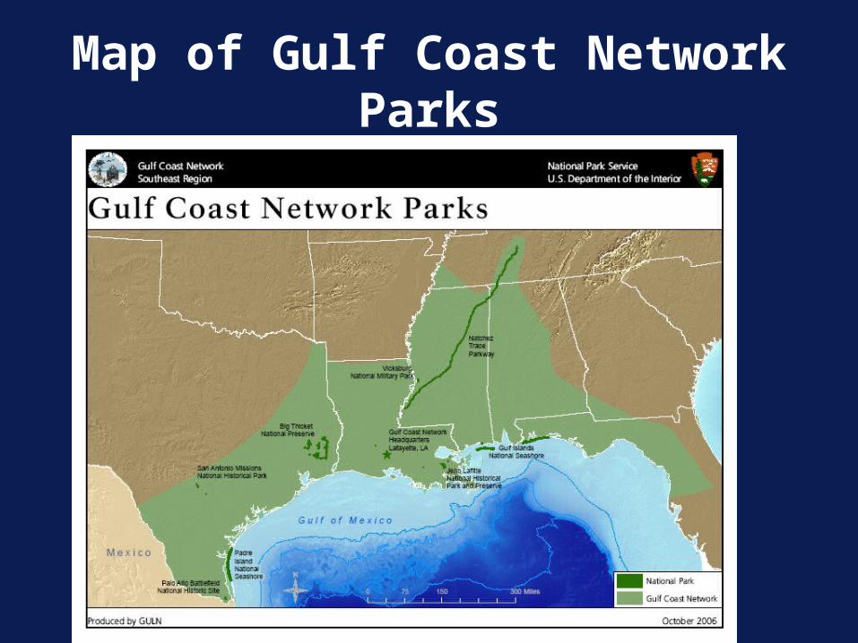
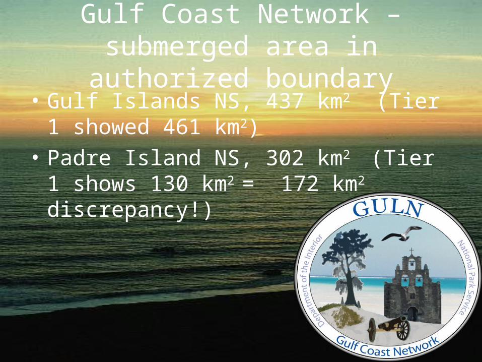
Gulf Coast Network –submerged area in authorized boundary
• Gulf Islands NS, 437 km2 (Tier 1 showed 461 km2)
• Padre Island NS, 302 km2 (Tier 1 shows 130 km2 = 172 km2 discrepancy!)
Gulf Coast Network
• Submerged Aquatic Vegetation was a high priority protocol – protocol work starts in 2009
• Texas –Need data mining.• Need geologic framework underpinning the islands• Need habitat classification especially seagrasses
and hard-bottom/oyster reefs• Want prediction of most vulnerable sites to
breaching of barrier islands.• Need information about these resources to
determine visitor impacts and how to manage them.
Big Thicket National PreserveBig Thicket National Preserve
Gulf Coast Network
• Key technical issues - water clarity and depth.
• Most information they have is not up to date.
• NGOM project at GUIS – huge step in the right direction
Southeast Coast Network SECN
a H t te a sr pC e a N S
F or t P u la sk i N M
O c m ul g ee N M
C o n g a re e
S w a m p N M
Fo r t S u m t er N M
C a n a v e r a l N S
C as ti llo D e S an M a rc o s
Fo r t M o u lt r ie N M
#
##
#
#
#
#
##
##
#
##
#
##
#
T im u c u an E H P
K e n n es a w M o u n ta in N M P
H o rse s h o e B en d N M P
C u m b e r la n d Is la n d N S
M o o res C r e e k N B
Fo rt Fre der ica N M
Fo rt M a ta n z as N M
Fo rt C ar o lin e N M
Cape Lookout NS
Southeast Coast Network
• Most parks own only to mean high tide (Cape Hatteras for example)
• 125 acres in Charleston Harbor• Odd corners Cumberland Island NS with
minimal submerged habitat • Canaveral NS boundary extends half mile
into Atlantic and includes portions of lagoon.
Southeast Coast Network –Benthic interest from network meetings
• Network wide interest was SAV distribution 1 km outside boundary.
• Similar need expressed to map hardscapes such as oyster beds.
• Sand flow budgets particularly for barrier islands were also expressed due to management issues with dredging, beach nourishing, jetties, etc.
Southeast Coast Network – Canaveral has the ownership and
the interest.
• Wants data mining of who is doing what in and around the park
• Wants evaluation of available data such as FL DEP seagrass maps from aerial surveys done every 3 yr.
• Wants oyster locations mapped in and around park.