98
Map Traffic Terrain Weather Procedures Default NAV Waypoint Info Nearest Utilities Services GTN 625/635/650 Cockpit Reference Guide Flight Plan System
Map
Traffic
Terrain
Weather
Procedures
Default NAV
Waypoint Info
Nearest
Utilities
Services
GTN 625/635/650Cockpit Reference Guide
Flight Plan
System
ii GTN 625/635/650 Cockpit Reference Guide 190-01004-04 Rev. L
War
ning
s, C
autio
ns, a
nd N
otes
ii
WARNING: Navigation and terrain separation must NOT be predicated upon the use of the terrain function. The GTN 6XX Terrain and HTerrain Proximity features are NOT intended to be used as a primary reference for terrain avoidance and do not relieve the pilot from the responsibility of being aware of surroundings during flight. Terrain Proximity is only to be used as an aid for terrain avoidance and is not certified for use in applications requiring a certified terrain awareness system. Terrain data is obtained from third party sources. Garmin is not able to independently verify the accuracy of the terrain data.
WARNING: The displayed minimum safe altitudes (MSAs) are only advisory in nature and should not be relied upon as the sole source of obstacle and terrain avoidance information. Always refer to current aeronautical charts for appropriate minimum clearance altitudes.
WARNING: The GTN 6XX has a very high degree of functional integrity. However, the pilot must recognize that providing monitoring and/or self-test capability for all conceivable system failures is not practical. Although unlikely, it may be possible for erroneous operation to occur without a fault indication shown by the GTN 6XX. It is thus the responsibility of the pilot to detect such an occurrence by means of cross-checking with all redundant or correlated information available in the cockpit.
WARNING: The altitude calculated by GPS receivers is geometric height above Mean Sea Level and could vary significantly from the altitude displayed by pressure altimeters, such as the output from the GDC 74A/B Air Data Computer, or other altimeters in aircraft. GPS altitude should never be used for vertical navigation. Always use pressure altitude displayed by pressure altimeters in the aircraft.
WARNING: Do not use outdated database information. Databases used in the GTN 6XX must be updated regularly in order to ensure that the information remains current. Pilots using an outdated database do so entirely at their own risk.
WARNING: Do not use basemap (land and water data) information for primary navigation. Basemap data is intended only to supplement other approved navigation data sources and should be considered as an aid to enhance situational awareness.
iii190-01004-04 Rev. L GTN 625/635/650 Cockpit Reference Guide
Warnings, Cautions, and Notes
WARNING: Traffic information shown on the GTN 6XX is provided as an aid in visually acquiring traffic. Pilots must maneuver the aircraft based only upon ATC guidance or positive visual acquisition of conflicting traffic.
WARNING: Do not use data link weather information for maneuvering in, near, or around areas of hazardous weather. Information contained within data link weather products may not accurately depict current weather conditions.
WARNING: Do not use the indicated data link weather product age to determine the age of the weather information shown by the data link weather product. Due to time delays inherent in gathering and processing weather data for data link transmission, the weather information shown by the data link weather product may be significantly older than the indicated weather product age.
WARNING: Never use datalinked weather to attempt to penetrate a thunderstorm. Both the FAA Advisory Circular, Subject: Thunderstorms, and the Airman’s Information Manual (AIM) recommend avoiding “by at least 20 miles any thunderstorm identified as severe or giving an intense radar echo.”
WARNING: For safety reasons, GTN 6XX operational procedures must be learned on the ground.
WARNING: To reduce the risk of unsafe operation, carefully review and understand all aspects of the GTN 625/635/650 Pilot’s Guide as well as this guide. Thoroughly practice basic operation prior to actual use. During flight operations, carefully compare indications from the GTN 6XX to all available navigation sources, including the information from other NAVAIDs, visual sightings, charts, etc. For safety purposes, always resolve any discrepancies before continuing navigation.
iv GTN 625/635/650 Cockpit Reference Guide 190-01004-04 Rev. L
War
ning
s, C
autio
ns, a
nd N
otes
iv
CAUTION: The United States government operates the Global Positioning System and is solely responsible for its accuracy and maintenance. The GPS system is subject to changes which could affect the accuracy and performance of all GPS equipment. Portions of the GTN 6XX utilize GPS as a precision electronic NAVigation AID (NAVAID). Therefore, as with all NAVAIDs, information presented by the GTN 6XX can be misused or misinterpreted and, therefore, become unsafe.
CAUTION: The GTN 6XX does not contain any user-serviceable parts. Repairs should only be made by an authorized Garmin service center. Unauthorized repairs or modifications could void both the warranty and the pilot’s authority to operate this device under FAA/FCC regulations.
CAUTION: The display lens has a special anti-reflective coating that is very sensitive to waxes and abrasive cleaners. CLEANERS CONTAINING AMMONIA WILL HARM THE ANTI-REFLECTIVE COATING. It is very important to clean the display using a clean, lint-free cloth and an eyeglass lens cleaner that is specified as safe for anti-reflective coatings.
CAUTION: TFRs provided by datalink weather sources (i.e., FIS-B and SiriusXM) are only advisory and do not replace a thorough preflight briefing on TFR times and locations. Not all TFRs may be shown. To determine accurate TFR information, verify with official sources, i.e., preflight planning or flight service center.
NOTE: All visual depictions contained within this document, including screen images of the GTN bezel and displays, are subject to change and may not reflect the most current GTN software. Depictions of equipment may differ slightly from the actual equipment.
NOTE: This device complies with part 15 of the FCC Rules. Operation is subject to the following two conditions: (1) this device may not cause harmful interference, and (2) this device must accept any interference received, including interference that may cause undesired operation.
NOTE: This product, its packaging, and its components contain chemicals known to the State of California to cause cancer, birth defects, or reproductive harm. This notice is being provided in accordance with California’s Proposition 65. If you have any questions or would like additional information, please refer to our website at www.garmin.com/prop65.
v190-01004-04 Rev. L GTN 625/635/650 Cockpit Reference Guide
Warnings, Cautions, and Notes
NOTE: Canadian Installations: In accordance with Canadian Radio Specifications Standard 102 (RSS 102), RF field strength exposure to persons from an antenna connected to this device should be limited to 60V/m for controlled environment and 28 V/m for uncontrolled environment.
NOTE: Do not use the SafeTaxi function as the basis for ground maneuvering. SafeTaxi does not comply with the requirements of AC 120-76C and is not qualified to be used as an airport moving map display (AMMD). SafeTaxi should only be used by the flight crew to orient themselves on the airport surface.
NOTE: The FAA has asked Garmin to remind pilots who fly with Garmin database-dependent avionics of the following:
• It is the pilot’s responsibility to remain familiar with all FAA regulatory and advisory guidance and information related to the use of databases in the National Airspace System.
• Garmin equipment will only recognize and use databases that are obtained from Garmin or Jeppesen. Databases obtained from Garmin or Jeppesen are assured compliance with all data quality requirements (DQRs) by virtue of a Type 2 Letter of Authorization (LOA) from the FAA. A copy of the Type 2 LOA is available for each database at www.flyGarmin.com.
• Use of a current Garmin or Jeppesen database in your Garmin equipment is required for compliance with established FAA regulatory guidance, but does not constitute authorization to fly any and all terminal procedures that may be presented by the system. It is the pilot’s responsibility to operate in accordance with established AFM(S) and regulatory guidance or limitations as applicable to the pilot, the aircraft, and installed equipment.
NOTE: The pilot/operator must review and be familiar with Garmin’s database exclusion list as discussed in SAIB CE-14-04 to determine what data may be incomplete. To see if an exclusion report exists for a specific database, visit www.flyGarmin.com.

vi GTN 625/635/650 Cockpit Reference Guide 190-01004-04 Rev. L
War
ning
s, C
autio
ns, a
nd N
otes
vi
NOTE: The pilot/operator must have access to Garmin and Jeppesen database alerts and consider their impact on the intended aircraft operation. For a current list of aviation database alerts, visit www.flyGarmin.com.
NOTE: If the pilot/operator wants or needs to adjust the database, visit www.flyGarmin.com.
NOTE: Garmin requests the flight crew report any observed discrepancies related to database information. These discrepancies could come in the form of an incorrect procedure; incorrectly identified terrain, obstacles and fixes; or any other displayed item used for navigation or communication in the air or on the ground. To report an aviation database error, visit www.flyGarmin.com.
NOTE: The GTN touchscreen may not respond to touch commands if condensation or moisture accumulate on the touchscreen.
NOTE: Depending on software version and configuration, GTN features and screen images may differ from those shown in this manual. Refer to the GTN 625/635/650 Pilot’s Guide (P/N 190-01004-03) for more information on specific GTN software versions.

vii190-01004-04 Rev. L GTN 625/635/650 Cockpit Reference Guide
Record of Revisions
Part Number Revision Date Description190-01004-04 A
BC
DEFGHJKL
2/20113/20113/2011
11/20122/201310/20138/20147/20151/20169/20168/2017
Initial Release.Updated message list.Updated part number on back cover only.Added v3.00 functionality.Added v4.00 functionality.Added v5.00 functionality.Added v5.11 functionality. Added v6.00 functionality.Added v6.10 functionality.Added v6.20 functionality.Added v6.30 funcitonality.

viii GTN 625/635/650 Cockpit Reference Guide 190-01004-04 Rev. L
TABLE OF CONTENTSIntroduction ...................................................................................................... 1
Direct-To Navigation .................................................................................................................... 2NAV/COM Radio ................................................................................................ 3
Touchscreen Entry ....................................................................................................................... 3Selecting a NAV/COM Frequency using Rotary Knobs ................................................................... 4Frequency Flip/Flop ...................................................................................................................... 4Voice Commands ......................................................................................................................... 4
Transponder ...................................................................................................... 5Transponder Control .................................................................................................................... 5TCAS II Transponder Mode Controls ............................................................................................. 6Special Squawk Codes ................................................................................................................. 6
Map .................................................................................................................. 7Changing User Fields ................................................................................................................... 8Pan Mode ................................................................................................................................... 9User Waypoints ........................................................................................................................... 9Creating (or Editing) a Flight Plan in Pan Mode .......................................................................... 10
Traffic .............................................................................................................. 11Traffic System Status Annunciations ........................................................................................... 12TCAS ......................................................................................................................................... 14TCAD ........................................................................................................................................ 15ADS-B Traffic ............................................................................................................................. 16
Terrain............................................................................................................. 18TAWS ........................................................................................................................................ 18HTAWS ...................................................................................................................................... 19
Weather .......................................................................................................... 20SiriusXM® Weather (Optional) .................................................................................................... 20FIS-B Weather ........................................................................................................................... 21Stormscope® Weather (Optional)................................................................................................ 22Connext Weather (Optional) ...................................................................................................... 23
Default NAV .................................................................................................... 24
Flight Plan ...................................................................................................... 25Creating a Flight Plan ................................................................................................................ 25Flight Plan Menu ....................................................................................................................... 26Airways ..................................................................................................................................... 27
Procedures ...................................................................................................... 28Departures, Arrivals, and Approaches.......................................................................................... 28Flying the Missed Approach ....................................................................................................... 29Flying an Approach with a Hold ................................................................................................. 29
Nearest ........................................................................................................... 30
ix190-01004-04 Rev. L GTN 625/635/650 Cockpit Reference Guide
Waypoint Info ................................................................................................. 31Creating a User Waypoint .......................................................................................................... 32
Services .......................................................................................................... 33Phone ....................................................................................................................................... 34SMS Text ................................................................................................................................... 34Music ........................................................................................................................................ 35Position Reports ........................................................................................................................ 36Contacts ................................................................................................................................... 37
Utilities ........................................................................................................... 38Vertical Calculator (VCALC) ....................................................................................................... 39
System ............................................................................................................ 40GTN-GTN Crossfilling ................................................................................................................ 41GTN-GNS Crossfilling ............................................................................................................... 42Connext Setup - Flight Stream 210 and 510 ............................................................................... 43Pairing a Device ......................................................................................................................... 44Connext Operation with Flight Stream 210 and 510 ................................................................... 44Connext Setup - Other Bluetooth Devices ................................................................................... 46
Symbols .......................................................................................................... 47Map Symbols............................................................................................................................. 47SafeTaxi™ Symbols ................................................................................................................... 48Traffic Symbols .......................................................................................................................... 48Terrain Obstacle Symbols ........................................................................................................... 50HTAWS Obstacle Symbols .......................................................................................................... 51Basemap Symbols ...................................................................................................................... 51Map Tool Bar Symbols ............................................................................................................... 52Miscellaneous Symbols .............................................................................................................. 53Stormscope® Symbols............................................................................................................... 54
Messages ........................................................................................................ 55
Glove Qualification Procedure ....................................................................... 80Tests Required for Glove Qualification ................................................................................. 81Tests Not Required for Glove Qualification ................................................................................. 82
Telligence Voice Command Qualification Procedure .................................................................................. 83
Voice Command Guidelines ....................................................................................................... 83Voice Command Instructions ...................................................................................................... 84Qualification Procedure ............................................................................................................. 84

x GTN 625/635/650 Cockpit Reference Guide 190-01004-04 Rev. L
This page intentionally left blank

1190-01004-04 Rev. L GTN 625/635/650 Cockpit Reference Guide
Introduction
INTRODUCTIONThis cockpit reference guide (CRG) is intended to serve as a quick reference
covering the basic features and operating procedures for the GTN 625/635/650. For detailed descriptions of any information found in this guide, refer to the latest revision of the GTN 625/635/650 Pilot’s Guide, P/N 190-01004-03, found at www.flyGarmin.com.
Dual Rotary Knob Function Hints
Large and Small Knobs
Active COM/NAVFrequency
Standby Com/Nav Frequency
Direct-To Key
Photo SensorHOME Key
Datacard
Home Page
Annunciations
Function Keys
Locking Screw
Message Annunciation
And Key
Xpdr Panel Controls (opt)
Volume, Squelch On/Off, and Nav ID On/Off
GTN 650 Front Panel/Main Page
Direct-To Key - Press to provide a direct course to a selected waypoint.
Home Key - A single press of the Home Key returns the user to the main page to access features. Pressing and holding the HOME key while on any page will display the default NAV page.
Volume and Squelch Knob - Controls volume of the COM and NAV radios. Press to use the IDENT function of the NAV radio. Pressing and holding the volume knob will change the frequency to emergency frequency.
Large and Small Knobs - Both are rotary knobs. The small knob can be pressed and held in to flip-flop COM and NAV frequencies.

2 GTN 625/635/650 Cockpit Reference Guide 190-01004-04 Rev. L
Introduction
Direct-To Navigation
OR
Press the Direct-To key to quickly navigate from your present position directly to a selected waypoint, flight plan waypoint, or nearest airport.
Direct-To a Waypoint1. Press Direct-To. 2. Touch the Waypoint Identifier field and select the characters for the
desired waypoint with the large and small right knobs or the touch keypad.
3. Touch Activate or press the small right knob. Text near the small right knob indicates its current function.
Direct-To a Flight Plan Waypoint
OR
1. Press Direct-To. 2. Touch the FPL tab and then the desired Flight Plan waypoint. 3. Touch Activate or press the small right knob.
Direct-To a Nearest Airport
OR
1. Press Direct-To. 2. Touch the NRST APT tab and then the desired airport from the Nearest
Airport list. Touch the Up or Down keys as needed to show more of the list. 3. Touch Activate or press the small right knob.
Direct-To a User-Defined Hold1. Press Direct-To and the touch Hold. 2. Touch the Course key and use the keypad to select the course. 3. Touch the Course Direction key to select inbound/outbound direction
and then the Turn key to select the turn direction. 4. Touch the Leg Type key to select time/distance and then touch the Leg
Time or Leg Distance key and use the keypad to select the leg length. 5. Touch the Expect Further Clearance key and use the keypad to select
the reminder time. 6. Touch the Load Hold key then the Hold Activate key.
3190-01004-04 Rev. L GTN 625/635/650 Cockpit Reference Guide
GPS/NAV/COM
NAV/COM RADIO
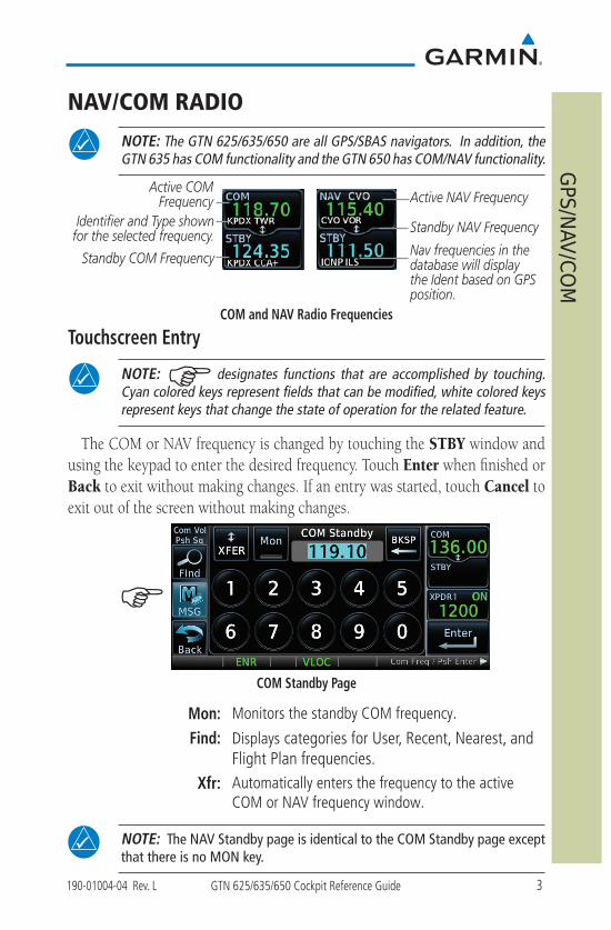
NOTE: The GTN 625/635/650 are all GPS/SBAS navigators. In addition, the GTN 635 has COM functionality and the GTN 650 has COM/NAV functionality.
Identifier and Type shown for the selected frequency.
Nav frequencies in the database will display the Ident based on GPS position.
Standby COM Frequency
Standby NAV Frequency
Active COM Frequency Active NAV Frequency
COM and NAV Radio Frequencies
Touchscreen Entry
NOTE: G designates functions that are accomplished by touching.Cyan colored keys represent fields that can be modified, white colored keys represent keys that change the state of operation for the related feature.
The COM or NAV frequency is changed by touching the STBY window and using the keypad to enter the desired frequency. Touch Enter when finished or Back to exit without making changes. If an entry was started, touch Cancel to exit out of the screen without making changes.
G
COM Standby Page
Mon: Monitors the standby COM frequency.
Find: Displays categories for User, Recent, Nearest, and Flight Plan frequencies.
Xfr: Automatically enters the frequency to the active COM or NAV frequency window.
NOTE: The NAV Standby page is identical to the COM Standby page except that there is no MON key.

4 GTN 625/635/650 Cockpit Reference Guide 190-01004-04 Rev. L
GPS/NAV/COM
Selecting a NAV/COM Frequency using Rotary Knobs
Press the center of the small right knob to change from the COM frequency display to the NAV frequency display.
1. Turn or momentarily press the small right knob once to highlight the STBY field of COM or NAV. The knob function defaults to COM after 30 seconds of inactivity.
2. Turn the large right knob to the desired MHz value.3. Turn the small right knob to the desired kHz value.4. Press the small right knob to confirm entry.
Frequency Flip/FlopTo flip/flop the active and standby NAV/COM frequencies, press and hold the
small knob or touch the active NAV/COM frequency field. An annunciation, Hold for Flip-Flop, will be displayed near the knobs.
Voice CommandsIf a GMA 350 is connected to the GTN, voice commands may be available. Refer
to GTN 6XX/7XX Telligence Voice Command Guide, P/N 190-01007-50.
5190-01004-04 Rev. L GTN 625/635/650 Cockpit Reference Guide
Transponder
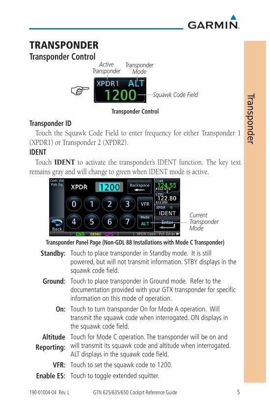
TRANSPONDERTransponder Control
Squawk Code Field
Transponder Mode
Active Transponder
GTransponder Control
Transponder IDTouch the Squawk Code Field to enter frequency for either Transponder 1
(XPDR1) or Transponder 2 (XPDR2).IDENT
Touch IDENT to activate the transponder’s IDENT function. The key text remains gray and will change to green when IDENT mode is active.
Current Transponder Mode
Transponder Panel Page (Non-GDL 88 Installations with Mode C Transponder)
Standby: Touch to place transponder in Standby mode. It is still powered, but will not transmit information. STBY displays in the squawk code field.
Ground: Touch to place transponder in Ground mode. Refer to the documentation provided with your GTX transponder for specific information on this mode of operation.
On: Touch to turn transponder On for Mode A operation. Will transmit the squawk code when interrogated. ON displays in the squawk code field.
Altitude Reporting:
Touch for Mode C operation. The transponder will be on and will transmit its squawk code and altitude when interrogated. ALT displays in the squawk code field.
VFR: Touch to set the squawk code to 1200.
Enable ES: Touch to toggle extended squitter.
6 GTN 625/635/650 Cockpit Reference Guide 190-01004-04 Rev. L
Transponder
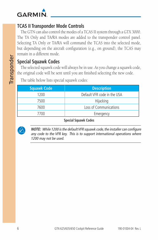
TCAS II Transponder Mode ControlsThe GTN can also control the modes of a TCAS II system through a GTX 3000.
The TA Only and TA/RA modes are added to the transponder control panel. Selecting TA Only or TA/RA will command the TCAS into the selected mode, but depending on the aircraft configuration (e.g., on ground), the TCAS may remain in a different mode.
Special Squawk CodesThe selected squawk code will always be in use. As you change a squawk code,
the original code will be sent until you are finished selecting the new code.
The table below lists special squawk codes:
Squawk Code Description1200 Default VFR code in the USA7500 Hijacking7600 Loss of Communications7700 Emergency
Special Squawk Codes
NOTE: While 1200 is the default VFR squawk code, the installer can configure any code to the VFR key. This is to support international operations where 1200 may not be used.

7190-01004-04 Rev. L GTN 625/635/650 Cockpit Reference Guide
Map
MAP
G
Map Page
G G
Touch to select the overlays (Terrain, TOPO, Airways, NEXRAD, and Traffic) that are displayed on the map page.
Touch to select the fields that are displayed in the four corners on the Map .
Touch to restore the user fields to Garmin factory defaults.
Touch to customize how the map, aviation, land, traffic, and weather information is displayed on the map page.
Touch, hold and slide to set how much detail is shown on the map page.
Map Menu
8 GTN 625/635/650 Cockpit Reference Guide 190-01004-04 Rev. L
Map
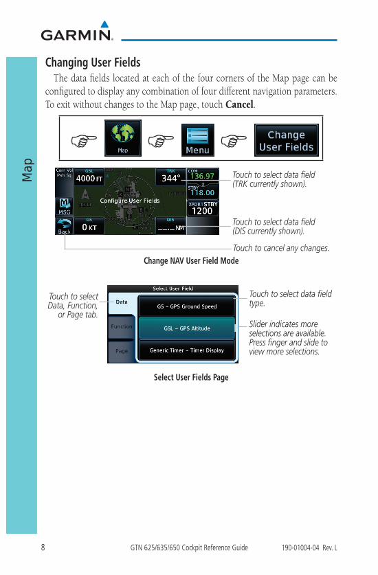
Changing User FieldsThe data fields located at each of the four corners of the Map page can be
configured to display any combination of four different navigation parameters. To exit without changes to the Map page, touch Cancel.
G G
G
Touch to select data field(TRK currently shown).
Touch to select data field(DIS currently shown).
Touch to cancel any changes.Change NAV User Field Mode
Touch to select data field type.
Touch to select Data, Function,
or Page tab.Slider indicates more selections are available. Press finger and slide to view more selections.
Select User Fields Page
9190-01004-04 Rev. L GTN 625/635/650 Cockpit Reference Guide
Map
Pan Mode
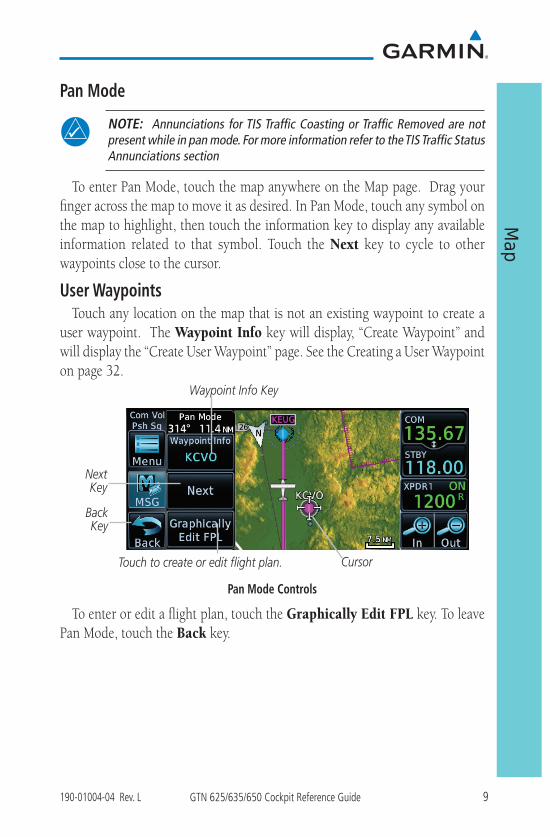
NOTE: Annunciations for TIS Traffic Coasting or Traffic Removed are not present while in pan mode. For more information refer to the TIS Traffic Status Annunciations section
To enter Pan Mode, touch the map anywhere on the Map page. Drag your finger across the map to move it as desired. In Pan Mode, touch any symbol on the map to highlight, then touch the information key to display any available information related to that symbol. Touch the Next key to cycle to other waypoints close to the cursor.
User WaypointsTouch any location on the map that is not an existing waypoint to create a
user waypoint. The Waypoint Info key will display, “Create Waypoint” and will display the “Create User Waypoint” page. See the Creating a User Waypoint on page 32.
Cursor
Waypoint Info Key
BackKey
Touch to create or edit flight plan.
Next Key
Pan Mode Controls
To enter or edit a flight plan, touch the Graphically Edit FPL key. To leave Pan Mode, touch the Back key.
10 GTN 625/635/650 Cockpit Reference Guide 190-01004-04 Rev. L
Map
Creating (or Editing) a Flight Plan in Pan Mode
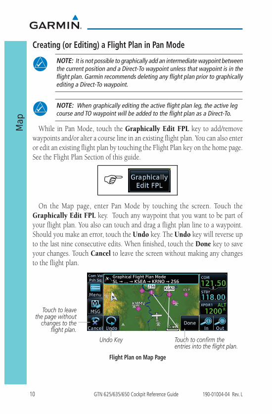
NOTE: It is not possible to graphically add an intermediate waypoint between the current position and a Direct-To waypoint unless that waypoint is in the flight plan. Garmin recommends deleting any flight plan prior to graphically editing a Direct-To waypoint.
NOTE: When graphically editing the active flight plan leg, the active leg course and TO waypoint will be added to the flight plan as a Direct-To.
While in Pan Mode, touch the Graphically Edit FPL key to add/remove waypoints and/or alter a course line in an existing flight plan. You can also enter or edit an existing flight plan by touching the Flight Plan key on the home page. See the Flight Plan Section of this guide.
G
On the Map page, enter Pan Mode by touching the screen. Touch the Graphically Edit FPL key. Touch any waypoint that you want to be part of your flight plan. You also can touch and drag a flight plan line to a waypoint. Should you make an error, touch the Undo key. The Undo key will reverse up to the last nine consecutive edits. When finished, touch the Done key to save your changes. Touch Cancel to leave the screen without making any changes to the flight plan.
Undo Key
Touch to leave the page without
changes to the flight plan.
Touch to confirm the entries into the flight plan.
Flight Plan on Map Page
11190-01004-04 Rev. L GTN 625/635/650 Cockpit Reference Guide
Traffic
TRAFFIC
G
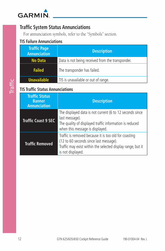
NOTE: Depending on which traffic device is installed and how it is configured, the pages may be different than what is shown. Refer to the GTN 625/635/650 Pilot’s Guide, P/N 190-01004-03, for more information.
Touch to select traffic mode. Selections are Operate and Standby.
Touch to activate testing mode.
Touch to select the altitude filter. Selections are Normal, Above, Below, or Unrestricted.
Traffic Page
The Test key places the traffic system in test mode. Not all traffic systems support Test mode. There are no menu options for the traffic page.
12 GTN 625/635/650 Cockpit Reference Guide 190-01004-04 Rev. L
Traffic
Traffic System Status AnnunciationsFor annunciation symbols, refer to the “Symbols” section.
TIS Failure AnnunciationsTraffic Page
AnnunciationDescription
No Data Data is not being received from the transponder.
Failed The transponder has failed.
Unavailable TIS is unavailable or out of range.
TIS Traffic Status AnnunciationsTraffic Status
Banner Annunciation
Description
Traffic Coast 9 SEC
The displayed data is not current (6 to 12 seconds since last message). The quality of displayed traffic information is reduced when this message is displayed.
Traffic Removed
Traffic is removed because it is too old for coasting (12 to 60 seconds since last message). Traffic may exist within the selected display range, but it is not displayed.
13190-01004-04 Rev. L GTN 625/635/650 Cockpit Reference Guide
Traffic
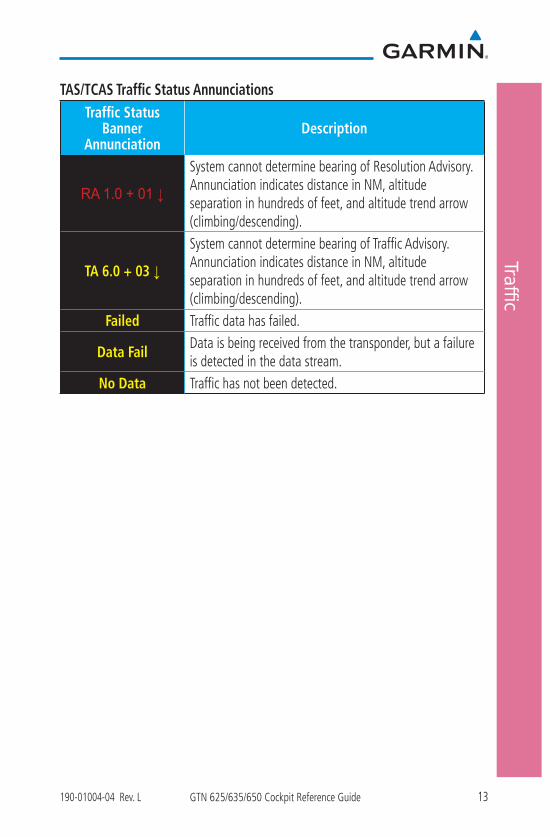
TAS/TCAS Traffic Status AnnunciationsTraffic Status
Banner Annunciation
Description
RA 1.0 + 01 ↓
System cannot determine bearing of Resolution Advisory. Annunciation indicates distance in NM, altitude separation in hundreds of feet, and altitude trend arrow (climbing/descending).
TA 6.0 + 03 ↓
System cannot determine bearing of Traffic Advisory. Annunciation indicates distance in NM, altitude separation in hundreds of feet, and altitude trend arrow (climbing/descending).
Failed Traffic data has failed.
Data FailData is being received from the transponder, but a failure is detected in the data stream.
No Data Traffic has not been detected.
14 GTN 625/635/650 Cockpit Reference Guide 190-01004-04 Rev. L
Traffic
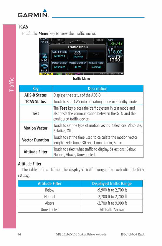
TCASTouch the Menu key to view the Traffic menu.
Traffic Menu
Key DescriptionADS-B Status Displays the status of the ADS-B. TCAS Status Touch to set TCAS into operating mode or standby mode.
TestThe Test key places the traffic system in test mode and also tests the communication between the GTN and the configured traffic device.
Motion VectorTouch to set the type of motion vector. Selections: Absolute, Relative, Off.
Vector DurationTouch to set the time used to calculate the motion vector length. Selections: 30 sec, 1 min, 2 min, 5 min.
Altitude FilterTouch to select what traffic to display. Selections: Below, Normal, Above, Unrestricted.
Altitude FilterThe table below defines the displayed traffic ranges for each altitude filter
setting.
Altitude Filter Displayed Traffic RangeBelow -9,900 ft to 2,700 ft
Normal -2,700 ft to 2,700 ftAbove -2,700 ft to 9,900 ft
Unrestricted All Traffic Shown
15190-01004-04 Rev. L GTN 625/635/650 Cockpit Reference Guide
Traffic
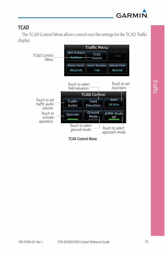
TCADThe TCAD Control Menu allows control over the settings for the TCAD Traffic
display.
TCAD Control Menu
Touch to set traffic audio
volume.Touch to activate
operation.
Touch to set local baro.
Touch to select approach mode.
Touch to select field elevation.
Touch to select ground mode.
TCAD Control Menu

16 GTN 625/635/650 Cockpit Reference Guide 190-01004-04 Rev. L
Traffic
ADS-B TrafficSelect a traffic target on the dedicated traffic page to obtain additional
information about the traffic target or to view all targets in a grouped target. When a grouped target is selected, the Next key on the dedicated traffic page will cycle through all targets located in close proximity to where the screen has been touched.
ADS-B and TCAS Status and Altitude
Filter
Touch to view Traffic Menu.
Selected Vector Motion and Duration
Touch for next target.
Range Rings
Range Ring Radius
Proximity Advisory, 1,200 ft Above
and Climbing
Traffic Direction of Travel
Selected Traffic Info
Map Orientation
Ownship Icon
ADS-B Traffic PageADS-B Traffic Menu
The Traffic Menu allows control of the traffic information display.
G G
Select Altitude Filter: Normal, Above, Below, Unrestricted.
Touch to perform traffic test.
Select ADS-B Status:Off, Surface, or
Airborne.Select Motion Vector:
Absolute, Relative, Off.
Select Vector Duration: 30 sec, 1 min, 2 min, 5 min.
Select TCAS Status:Operate and Standby.
ADS-B Traffic Menu
17190-01004-04 Rev. L GTN 625/635/650 Cockpit Reference Guide
Traffic
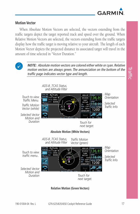
Motion Vector
When Absolute Motion Vectors are selected, the vectors extending from the traffic targets depict the target reported track and speed over the ground. When Relative Motion Vectors are selected, the vectors extending from the traffic targets display how the traffic target is moving relative to your aircraft. The length of each Motion Vector depicts the projected distance its associated target will travel in the amount of time selected in “Vector Duration.”
NOTE: Absolute motion vectors are colored either white or cyan. Relative motion vectors are always green. The annunciation on the bottom of the traffic page indicates vector type and length.
Selected Traffic Info
ADS-B ,TCAS Status, and Altitude Filter
Touch to view Traffic Menu.
Selected Vector Motion and
Duration Touch for next target.
Map Orientation
Traffic Motion Vector (white)
Absolute Motion (White Vectors)
Selected Traffic Info
ADS-B ,TCAS Status, and Altitude Filter
Touch to view traffic menu..
Selected Vector Motion and
Duration Touch for next target.
Map Orientation
Traffic Motion Vector (green)
Relative Motion (Green Vectors)

18 GTN 625/635/650 Cockpit Reference Guide 190-01004-04 Rev. L
Terrain
TERRAIN
NOTE: Features may vary, depending on your configuration. For the terrain scale, refer to the “Symbols” section.
G
Heading Annunciation
Aircraft GSL value(GPS derived)
Terrain Overlay
Active Flight Plan Leg Terrain TypeTerrain Legend
Obstacles
Terrain Page
TAWS
G G
Touch to display the active flight plan.
Touch to suppressTAWS alerts.
Touch to test the TAWS system.
Touch to display terrain as a 360° ring or a 120° arc.
Touch to display the Terrain Legend.
TAWS Terrain Menu
19190-01004-04 Rev. L GTN 625/635/650 Cockpit Reference Guide
Terrain
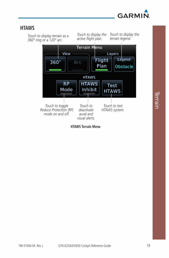
HTAWSTouch to display the active flight plan.
Touch to display terrain as a 360° ring or a 120° arc.
Touch to display the terrain legend.
Touch to toggle Reduce Protection (RP)
mode on and off.
Touch to test HTAWS system.
Touch to deactivate aural and
visual alerts.
HTAWS Terrain Menu

20 GTN 625/635/650 Cockpit Reference Guide 190-01004-04 Rev. L
Weather
WEATHER
NOTE: Features may vary, depending on your configuration. Refer to the GTN 625/635/650 Pilot’s Guide, P/N 190-01004-03 for more information.
G
SiriusXM® Weather (Optional)
G G
G
Touch to select the weather overlay map orientation.
Touch NEXRAD key to select Off, US, or Canada NEXRAD.
Touch to display the
legend.Touch to scroll to view the remaining selections.Touch keys to select weather product.
Green bar indicates selected product.
SiriusXM Weather Menu

21190-01004-04 Rev. L GTN 625/635/650 Cockpit Reference Guide
Weather
FIS-B Weather
G G
G
Touch keys to select weather product.
Green bar indicates selected product.
Touch NEXRAD key to select: Off, US, or Canada NEXRAD.
Touch to display the legend.
Touch to select the weather overlay map
orientation.
FIS-B Weather Menu

22 GTN 625/635/650 Cockpit Reference Guide 190-01004-04 Rev. L
Weather
Stormscope® Weather (Optional)
NOTE: Refer to the WX-500 Pilot’s Guide for a detailed description of the WX-500 Stormscope.
G G
G
Displays Stormscope as 360° ring or 120° arc.
Touch to select operating mode.
Stormscope Menu

23190-01004-04 Rev. L GTN 625/635/650 Cockpit Reference Guide
Weather
Connext Weather (Optional)
G G
G
Connext Weather Menu
Key DescriptionPRECIP Touch to toggle the display of precipitation.
Lightning Touch to toggle the display of lightning.IR Satellite Touch to toggle the display of IR satellite information.
METAR Touch to toggle the display of METARs.
PIREPTouch to toggle the display of PIREPs, Winds Aloft, and SIGMETs/AIRMETs.
Winds AloftTouch to toggle the display of PIREPs, Winds Aloft, and SIGMETs/AIRMETs.
SIGMET/AIRMETTouch to toggle the display of PIREPs, Winds Aloft, and SIGMETs/AIRMETs.
Connext SettingsTouch to set region of coverage, data request and to view the status of the datalink.
OrientationTouch to display map orientation options. North Up, Track Up, or Heading Up.
Legend Touch to display the legend of weather information.

24 GTN 625/635/650 Cockpit Reference Guide 190-01004-04 Rev. L
Defa
ult N
AV
DEFAULT NAV
G
Data Fields
Default Navigation Page
G G
Touch to restore the default user fields.
Touch to configure the user fields.
Default Navigation MenuData field selections are the same as the “Changing User Fields” selections
listed in the Map section.

25190-01004-04 Rev. L GTN 625/635/650 Cockpit Reference Guide
Active Flight Plan
FLIGHT PLAN
G
Creating a Flight PlanOn the Flight Plan page, touch “Add Waypoint” to display an alphanumeric
keypad. Type in the airport identifier and touch Enter. If unknown, touch the Find key to search. To exit without making changes to the flight plan, touch the Cancel key.
GBackspace
Touch to select a group of letters.
Alphanumeric String Touch to select the individual letter of the group.
Keypad Entry
Sample Flight Plan
NOTE: Do not save flight plans that have modified procedures as this may produce undesirable results.
26 GTN 625/635/650 Cockpit Reference Guide 190-01004-04 Rev. L
Activ
e Fl
ight
Pla
n
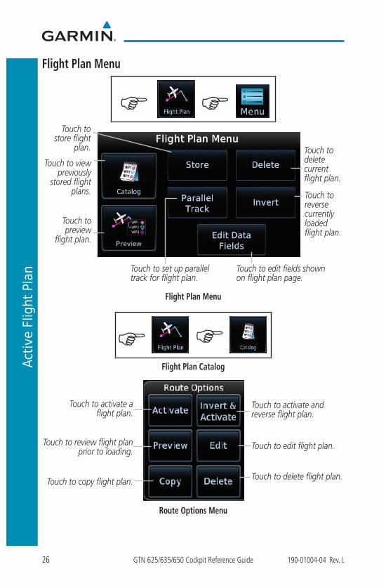
Flight Plan Menu
G G
Touch to set up parallel track for flight plan.
Touch to preview
flight plan.
Touch to store flight
plan.
Touch to view previously
stored flight plans.
Touch to edit fields shown on flight plan page.
Touch to reverse currently loaded flight plan.
Touch to delete current flight plan.
Flight Plan Menu
G G
Flight Plan Catalog
Touch to activate a flight plan.
Touch to edit flight plan.
Touch to delete flight plan.
Touch to activate and reverse flight plan.
Touch to review flight plan prior to loading.
Touch to copy flight plan.
Route Options Menu
27190-01004-04 Rev. L GTN 625/635/650 Cockpit Reference Guide
Active Flight Plan
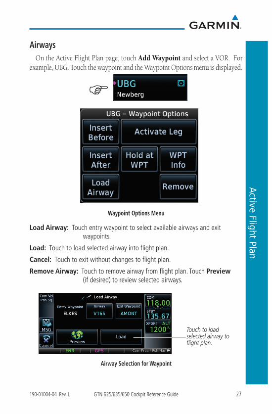
AirwaysOn the Active Flight Plan page, touch Add Waypoint and select a VOR. For
example, UBG. Touch the waypoint and the Waypoint Options menu is displayed.
G
Waypoint Options Menu
Load Airway: Touch entry waypoint to select available airways and exit waypoints.
Load: Touch to load selected airway into flight plan.
Cancel: Touch to exit without changes to flight plan.
Remove Airway: Touch to remove airway from flight plan. Touch Preview (if desired) to review selected airways.
Touch to load selected airway to flight plan.
Airway Selection for Waypoint
28 GTN 625/635/650 Cockpit Reference Guide 190-01004-04 Rev. L
Procedures
PROCEDURES
G
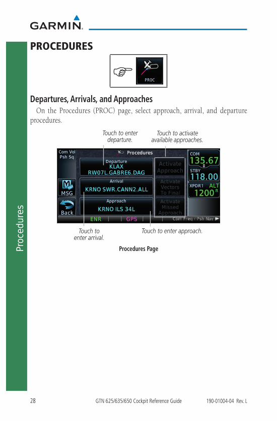
Departures, Arrivals, and ApproachesOn the Procedures (PROC) page, select approach, arrival, and departure
procedures.
Touch to activate available approaches.
Touch to enter departure.
Touch to enter arrival.
Touch to enter approach.
Procedures Page

29190-01004-04 Rev. L GTN 625/635/650 Cockpit Reference Guide
Procedures
Flying the Missed ApproachIn event of a missed approach, the GTN 6XX unit continues to give guidance
along an extension of the final course segment (FAF to MAP) until you manually initiate the missed approach procedure (as mentioned in reference to the “SUSP” advisory).
NOTE: If the unit is not configured for a CDI key, then the “Activate GPS Missed Approach” will only resume automatic waypoint sequencing. The user must switch to GPS navigation, if desired, by using their external source selection method (this is typical an EFIS system).
1. When the MAP is reached, a pop-up will appear.
Pop-Up Upon Reaching the MAP
2. Touch the Remain Suspended key to continue with sequencing suspended or touch Activate GPS Missed Approach for guidance to the Missed Approach Hold Point.
Flying an Approach with a HoldThe Flight Plan Page displays a timer or distance, as appropriate, during the
holding pattern. Use this timer or distance to fly the outbound portion of the holding pattern. The holding pattern is displayed on the Map Page and indicated as the active leg on the Active Flight Plan pages.
NOTE: If you need to lose extra altitude or speed by going around the holding pattern again, touch SUSP to manually suspend waypoint sequencing BEFORE crossing the holding waypoint the second time. If you’ve already passed this waypoint, re-activate the holding pattern leg.
30 GTN 625/635/650 Cockpit Reference Guide 190-01004-04 Rev. L
Nearest
NEAREST
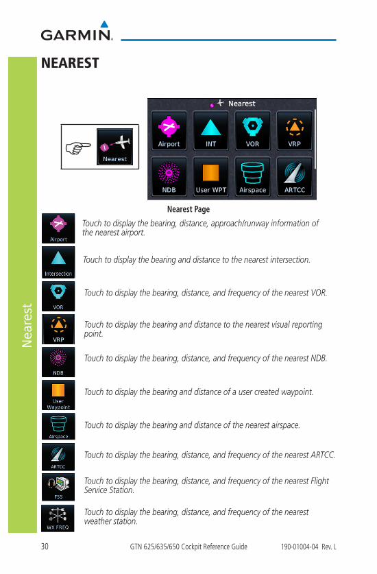
Nearest Page
Touch to display the bearing, distance, approach/runway information of the nearest airport.
Touch to display the bearing and distance to the nearest intersection.
Touch to display the bearing, distance, and frequency of the nearest VOR.
Touch to display the bearing, distance, and frequency of the nearest ARTCC.
Touch to display the bearing and distance of the nearest airspace.
Touch to display the bearing, distance, and frequency of the nearest Flight Service Station.
Touch to display the bearing, distance, and frequency of the nearest weather station.
Touch to display the bearing, distance, and frequency of the nearest NDB.
Touch to display the bearing and distance of a user created waypoint.
G
Touch to display the bearing and distance to the nearest visual reporting point.
31190-01004-04 Rev. L GTN 625/635/650 Cockpit Reference Guide
Waypoint Info
WAYPOINT INFO
G
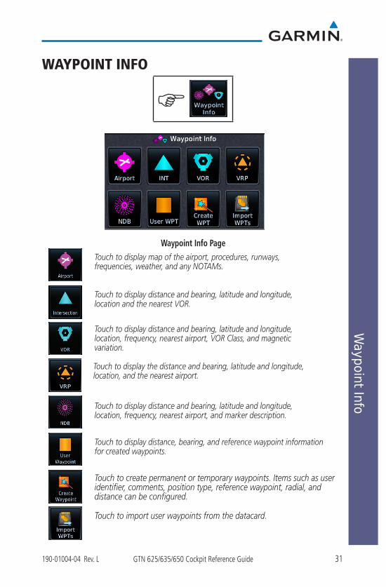
Waypoint Info Page
Touch to display the distance and bearing, latitude and longitude, location, and the nearest airport.
Touch to create permanent or temporary waypoints. Items such as user identifier, comments, position type, reference waypoint, radial, and distance can be configured.
Touch to display distance, bearing, and reference waypoint information for created waypoints.
Touch to display map of the airport, procedures, runways, frequencies, weather, and any NOTAMs.
Touch to display distance and bearing, latitude and longitude, location and the nearest VOR.
Touch to display distance and bearing, latitude and longitude, location, frequency, nearest airport, VOR Class, and magnetic variation.
Touch to display distance and bearing, latitude and longitude, location, frequency, nearest airport, and marker description.
Touch to import user waypoints from the datacard.

32 GTN 625/635/650 Cockpit Reference Guide 190-01004-04 Rev. L
Way
poin
t Inf
o
Creating a User Waypoint
G
1. Touch the Create Waypoint icon. If there are no user waypoints defined, the prompt, “No User Waypoints exist. Create User Waypoint?” will be displayed. Touch OK to continue.
2. Enter the desired name (identifier) and position, or reference another waypoint by radial and distance. The identifier can be a maximum of 6 characters and the comment can be a maximum of 24 characters.
3. Touch Create to confirm your entry.
Touch to enter name of
waypoint.Touch to edit
comment.
Touch to select radial and distance.
Preview
Touch to confirm entry.
Touch to create a temporary waypoint.
Touch to exit
without creating
user waypoint.
Create User Waypoint Page

33190-01004-04 Rev. L GTN 625/635/650 Cockpit Reference Guide
Services
SERVICES
G
Touch to send an SMS text.
Touch to view your contacts.
Touch to listen to music.
Touch to activate phone.
Touch to review
position report
settings.
Services Page
34 GTN 625/635/650 Cockpit Reference Guide 190-01004-04 Rev. L
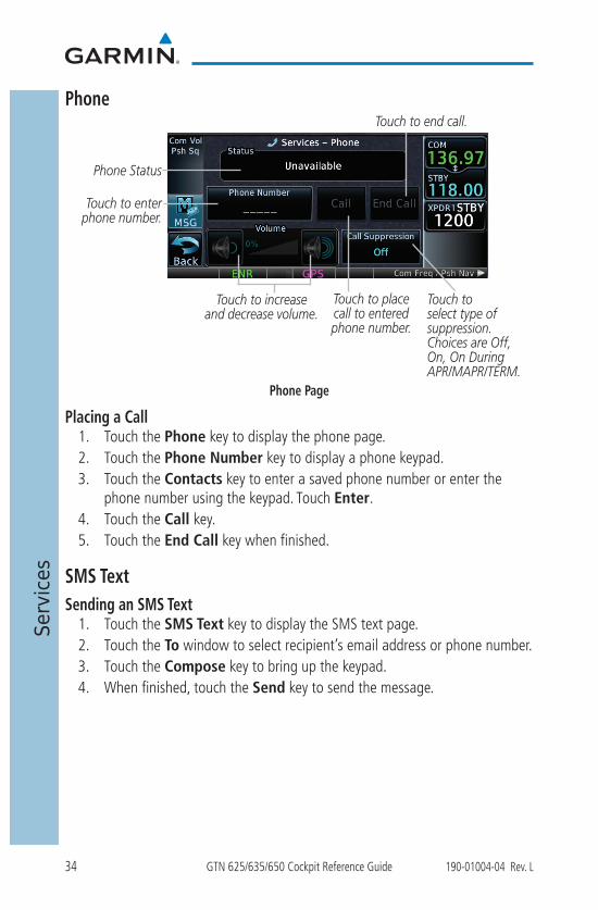
Services
Phone
Phone Status
Touch to enter phone number.
Touch to place call to entered phone number.
Touch to end call.
Touch to increase and decrease volume.
Touch to select type of suppression. Choices are Off, On, On During APR/MAPR/TERM.
Phone Page
Placing a Call1. Touch the Phone key to display the phone page.2. Touch the Phone Number key to display a phone keypad.3. Touch the Contacts key to enter a saved phone number or enter the
phone number using the keypad. Touch Enter. 4. Touch the Call key.5. Touch the End Call key when finished.
SMS TextSending an SMS Text
1. Touch the SMS Text key to display the SMS text page.2. Touch the To window to select recipient’s email address or phone number.3. Touch the Compose key to bring up the keypad.4. When finished, touch the Send key to send the message.

35190-01004-04 Rev. L GTN 625/635/650 Cockpit Reference Guide
Services
MusicTouch to browse categories.
Presets Key
Touch to see the status of the
GDL69 and list of subscribed
products.
Touch to adjust volume or mute.
Touch to select channel.
Touch to change channels manually.
Music Page
Selecting a Channel1. Touch the CH Number key to display a numeric keypad.2. Touch numbers of the channel number.3. Touch Enter to accept channel.
Adding Channels to Presets1. Touch the Presets key. The choices are XM1, XM2, and XM3. 2. Touch the Channel key and enter in the desired channel.3. Touch and hold the key of the preset where you want to store the channel
for three seconds. The key in the Preset Channel Bar will store the channel.
4. Follow the same steps to override a currently stored channel. To clear presets, change Channel to 0 and touch all presets until all read 0.

36 GTN 625/635/650 Cockpit Reference Guide 190-01004-04 Rev. L
Services
Position Reports
Touch to activate automatic reporting.
Status
Touch to enter frequency of reporting. Range is 2 to 60 minutes.
Touch to send position
report.
Position Reports Page
Position Reporting1. Touch the Position Reports key.2. Touch the Automatic Reporting key to enable reporting of position
automatically.3. After automatic reporting is enabled, touch the Report Period key to
display the keypad and enter the frequency of reporting. 4. Touch the Enter key to confirm your selection.
G

37190-01004-04 Rev. L GTN 625/635/650 Cockpit Reference Guide
Services
ContactsTouch to add name,
phone number, and email address of a contact.
Touch to search for a previously entered contact.
Current list of contacts.
Contacts Page
Adding a Contact1. Touch the Add key to display the Add Contact menu.2. Touch the Name key to enter the contact name (required). 3. Touch the Phone Number key to enter the contact phone number
(optional).4. Touch the Email Address key to enter the contact email address
(optional).5. Touch the Save Contact key to save entry to list. The list can hold 250
entries.
Editing a Contact1. In the contact list, touch the contact that you wish to edit. 2. Touch the Edit key to display the current contact formation. 3. Touch the information that you want to edit. When you’re finished, touch
Save Contact key. Touch the Back key at any time to leave the contact unchanged.
Deleting a Contact1. In the contact list, touch the contact that you wish to delete.2. Touch the Delete key. 3. Touch the OK key to delete contact. Touch the Cancel key to not make
any changes to contact in list.
38 GTN 625/635/650 Cockpit Reference Guide 190-01004-04 Rev. L
Utilities
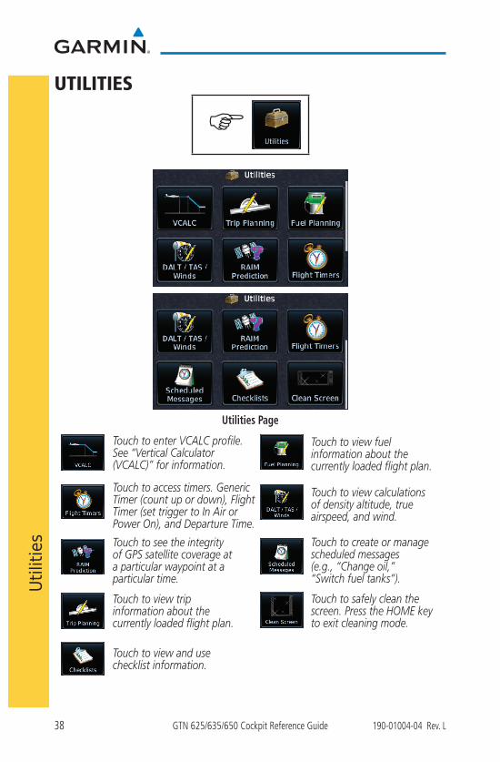
UTILITIES
G
Utilities Page
Touch to create or manage scheduled messages (e.g., “Change oil,” “Switch fuel tanks”).
Touch to enter VCALC profile. See “Vertical Calculator (VCALC)” for information.
Touch to view calculations of density altitude, true airspeed, and wind.
Touch to see the integrity of GPS satellite coverage at a particular waypoint at a particular time.
Touch to view trip information about the currently loaded flight plan.
Touch to view fuel information about the currently loaded flight plan.
Touch to access timers. Generic Timer (count up or down), Flight Timer (set trigger to In Air or Power On), and Departure Time.
Touch to safely clean the screen. Press the HOME key to exit cleaning mode.
Touch to view and use checklist information.
39190-01004-04 Rev. L GTN 625/635/650 Cockpit Reference Guide
Utilities
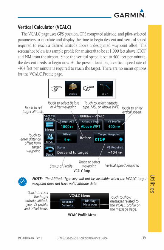
Vertical Calculator (VCALC)The VCALC page uses GPS position, GPS computed altitude, and pilot-selected
parameters to calculate and display the time to begin descent and vertical speed required to reach a desired altitude above a designated waypoint offset. The screenshot below is a sample profile for an aircraft to be at 1,000 feet above KTOP at 4 NM from the airport. Since the vertical speed is set to 400 feet per minute, the descent needs to begin now. At the present location, a vertical speed rate of -404 feet per minute is required to reach the target. There are no menu options for the VCALC Profile page.
G G
Touch to set target altitude.
Touch to select altitude type, MSL or Above WPT.
Touch to select Before or After waypoint. Touch to enter
vertical speed.
Touch to select waypoint.Status of Profile Vertical Speed Required
Touch to enter distance
offset from target
waypoint.
VCALC Page
NOTE: The Altitude Type key will not be available when the VCALC target waypoint does not have valid altitude data.
Touch to reset the target
altitude, altitude type, VS profile,
and offset fields.
Touch to show messages related to the VCALC profile on the message page.
VCALC Profile Menu
40 GTN 625/635/650 Cockpit Reference Guide 190-01004-04 Rev. L
System
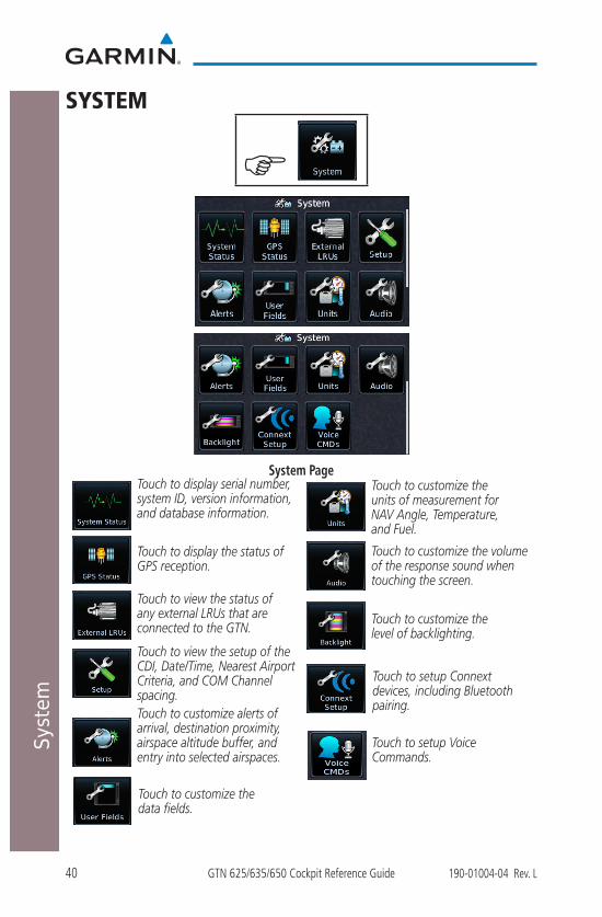
SYSTEM
G
System PageTouch to customize the units of measurement for NAV Angle, Temperature, and Fuel.
Touch to customize alerts of arrival, destination proximity, airspace altitude buffer, and entry into selected airspaces.
Touch to view the setup of the CDI, Date/Time, Nearest Airport Criteria, and COM Channel spacing.
Touch to customize the volume of the response sound when touching the screen.
Touch to display serial number, system ID, version information, and database information.
Touch to display the status of GPS reception.
Touch to view the status of any external LRUs that are connected to the GTN.
Touch to customize the level of backlighting.
Touch to setup Connext devices, including Bluetooth pairing.
Touch to customize the data fields.
Touch to setup Voice Commands.

41190-01004-04 Rev. L GTN 625/635/650 Cockpit Reference Guide
System
GTN-GTN CrossfillingDual units may be interfaced to crossfill information between the two units.
This option will not be available unless dual units are configured. The following data is always crossfilled:
• User waypoints
• Flight plan catalog
• Alerts (Pop-up acknowledgement for traffic, missed approach waypoint, and altitude leg)
• External sensors (transponder status and commands, synchro heading)
• System setup Favorite NAV frequencies Date/Time convention Nearest airport criteria Units (NAV angle, Fuel, and Temperature) Favorite COM frequencies CDI Scale setting ILS CDI Capture setting
This data is crossfilled only if crossfill is turned on by the pilot:
• Active navigation (flight plan)
1. While viewing the System Setup page, touch the Crossfill key to toggle between Enabled and Disabled Crossfill.
2. When Crossfill is about to be enabled, you will be prompted to note that data will be overwritten in the other unit. Touch OK to enable Crossfill or touch Cancel to return to the System Setup page without enabling Crossfill.
Touch OK to enable crossfill with dual units.
Confirming Crossfill Selection
42 GTN 625/635/650 Cockpit Reference Guide 190-01004-04 Rev. L
System
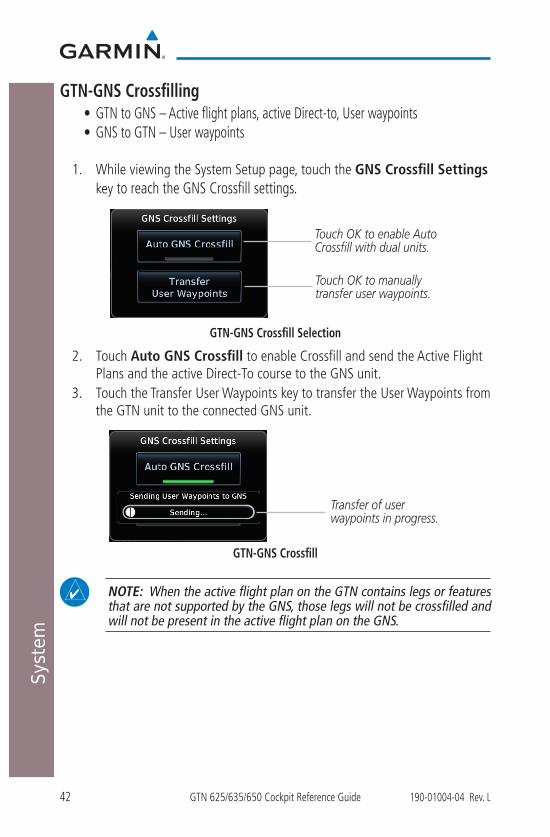
GTN-GNS Crossfilling • GTN to GNS – Active flight plans, active Direct-to, User waypoints• GNS to GTN – User waypoints
1. While viewing the System Setup page, touch the GNS Crossfill Settings key to reach the GNS Crossfill settings.
Touch OK to enable Auto Crossfill with dual units.
Touch OK to manually transfer user waypoints.
GTN-GNS Crossfill Selection
2. Touch Auto GNS Crossfill to enable Crossfill and send the Active Flight Plans and the active Direct-To course to the GNS unit.
3. Touch the Transfer User Waypoints key to transfer the User Waypoints from the GTN unit to the connected GNS unit.
Transfer of user waypoints in progress.
GTN-GNS Crossfill
NOTE: When the active flight plan on the GTN contains legs or features that are not supported by the GNS, those legs will not be crossfilled and will not be present in the active flight plan on the GNS.
43190-01004-04 Rev. L GTN 625/635/650 Cockpit Reference Guide
System
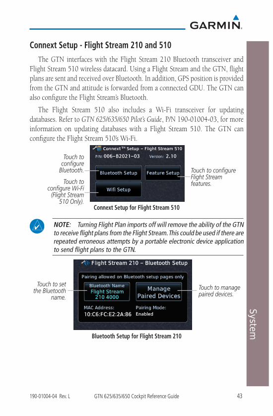
Connext Setup - Flight Stream 210 and 510The GTN interfaces with the Flight Stream 210 Bluetooth transceiver and
Flight Stream 510 wireless datacard. Using a Flight Stream and the GTN, flight plans are sent and received over Bluetooth. In addition, GPS position is provided from the GTN and attitude is forwarded from a connected GDU. The GTN can also configure the Flight Stream’s Bluetooth.
The Flight Stream 510 also includes a Wi-Fi transceiver for updating databases. Refer to GTN 625/635/650 Pilot’s Guide, P/N 190-01004-03, for more information on updating databases with a Flight Stream 510. The GTN can configure the Flight Stream 510’s Wi-Fi.
Touch to configure Flight Stream features.
Touch to configure
Bluetooth.
Connext Setup for Flight Stream 510
NOTE: Turning Flight Plan imports off will remove the ability of the GTN to receive flight plans from the Flight Stream. This could be used if there are repeated erroneous attempts by a portable electronic device application to send flight plans to the GTN.
Touch to set the Bluetooth
name.
Touch to manage paired devices.
Bluetooth Setup for Flight Stream 210
Touch to configure Wi-Fi
(Flight Stream 510 Only).

44 GTN 625/635/650 Cockpit Reference Guide 190-01004-04 Rev. L
System
Pairing a DeviceNew devices can only be paired with the Flight Stream when it is in “Pairing
Mode.” The Flight Stream will be in pairing mode when the GTN is navigated to the Connext Setup page and/or the Manage Paired Devices page. The pairing must be initiated by the portable device. Pop-ups, requesting confirmation of the pairing, display on both the GTN and the portable device.
Pairing Confirmation Pop-up
Selecting “Manage Paired Devices” opens a page that lists all of devices paired to the Flight Stream.
Connext Operation with Flight Stream 210 and 510Data output from the GTN and Flight Stream occurs automatically and
requires no pilot action (such as, flight plan, GPS position, and attitude). Additionally, ADS-B traffic and weather can be output from the Flight Stream when connected to a GDL 88 or GTX 345 and XM WX and SiriusXM satellite radio information can output when connected a GDL 69. From the Connext Setup page, the pilot can enable/disable flight plan importing, change the Flight Stream Bluetooth name, and manage paired devices. The Flight Stream 210 and 510 also support sending and receiving GSR 56 SMS messages and controlling the GSR 56 Iridium phone when used with a compatible portable application.
From the Connext Setup page, the pilot can enable/disable Flight Stream features (flight plan importing, phone/SMS, and Database transfers), setup Flight Stream Bluetooth and Wi-Fi, and manage paired Bluetooth devices.
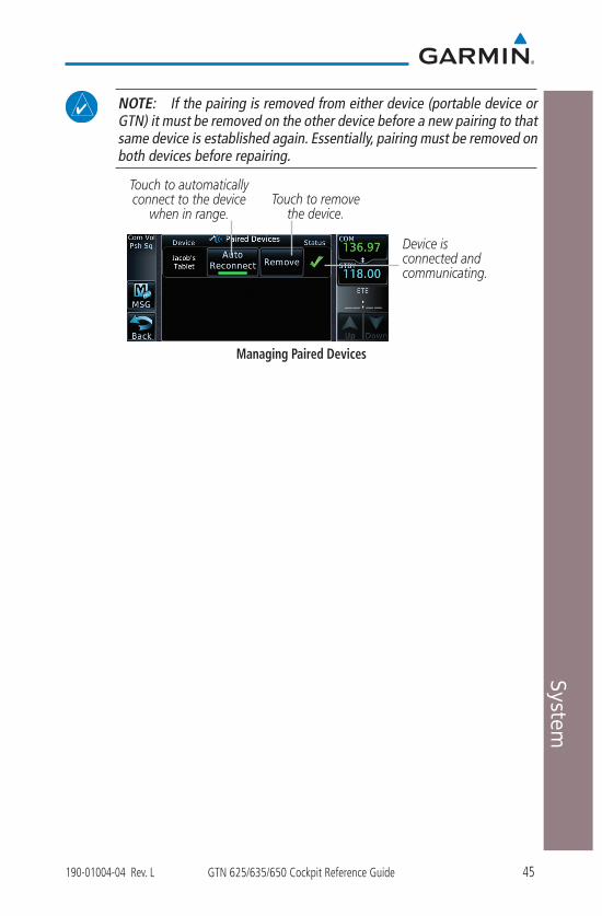
On the GTN’s Paired Devices page, the device status indicates if the portable device is connected and communicating with the Flight Stream. The “Auto- Reconnect” setting determines if the Flight Stream will automatically connect to up to four devices when in range. When this setting is disabled, the pilot must initiate the connection from the device. For devices that always reconnect automatically, this setting will not be shown. Removing a device from this page by pressing “Remove” will require the device to be paired again before transferring data.
45190-01004-04 Rev. L GTN 625/635/650 Cockpit Reference Guide
System
NOTE: If the pairing is removed from either device (portable device or GTN) it must be removed on the other device before a new pairing to that same device is established again. Essentially, pairing must be removed on both devices before repairing.
Device is connected and communicating.
Touch to remove the device.
Touch to automatically connect to the device
when in range.
Managing Paired Devices
46 GTN 625/635/650 Cockpit Reference Guide 190-01004-04 Rev. L
System
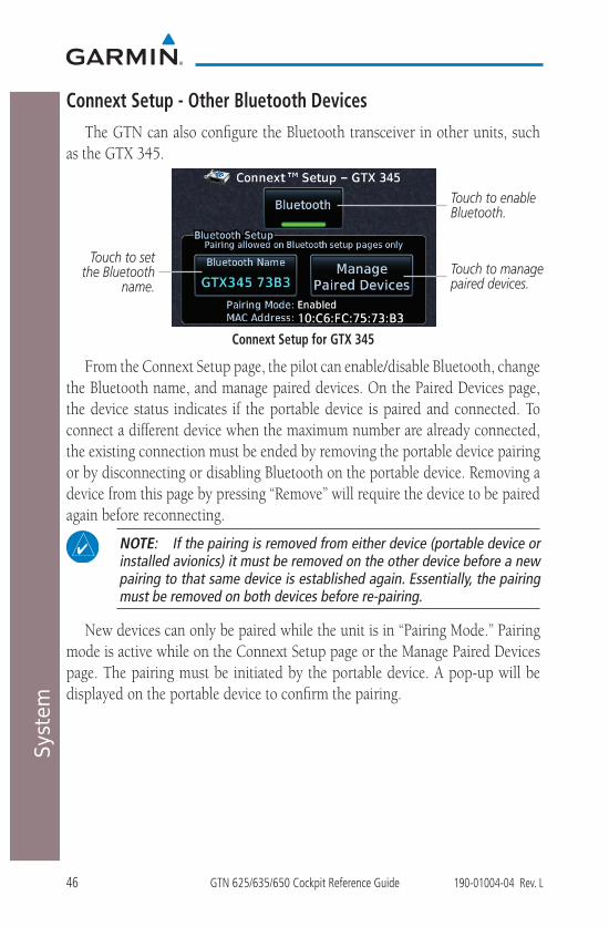
Connext Setup - Other Bluetooth DevicesThe GTN can also configure the Bluetooth transceiver in other units, such
as the GTX 345.
Touch to set the Bluetooth
name.
Touch to enable Bluetooth.
Touch to manage paired devices.
Connext Setup for GTX 345
From the Connext Setup page, the pilot can enable/disable Bluetooth, change the Bluetooth name, and manage paired devices. On the Paired Devices page, the device status indicates if the portable device is paired and connected. To connect a different device when the maximum number are already connected, the existing connection must be ended by removing the portable device pairing or by disconnecting or disabling Bluetooth on the portable device. Removing a device from this page by pressing “Remove” will require the device to be paired again before reconnecting.
NOTE: If the pairing is removed from either device (portable device or installed avionics) it must be removed on the other device before a new pairing to that same device is established again. Essentially, the pairing must be removed on both devices before re-pairing.
New devices can only be paired while the unit is in “Pairing Mode.” Pairing mode is active while on the Connext Setup page or the Manage Paired Devices page. The pairing must be initiated by the portable device. A pop-up will be displayed on the portable device to confirm the pairing.

47190-01004-04 Rev. L GTN 625/635/650 Cockpit Reference Guide
Symbols
SYMBOLSMap Symbols
Symbol Description
Airport with hard surface runway(s); Serviced, Primary runway shown
Airport with hard surface runway(s); Non-Serviced, Primary runway shownAirport with soft surface runway(s) only, Serviced
Airport with soft surface runway(s) only, Non-Serviced
Unknown Airport
Restricted (Private) Airfield
Intersection
VOR
VORTAC
VOR/DME
TACAN
DME
NDB
Locator Outer Marker
Heliport
User Waypoint
VRP
48 GTN 625/635/650 Cockpit Reference Guide 190-01004-04 Rev. L
Symbols
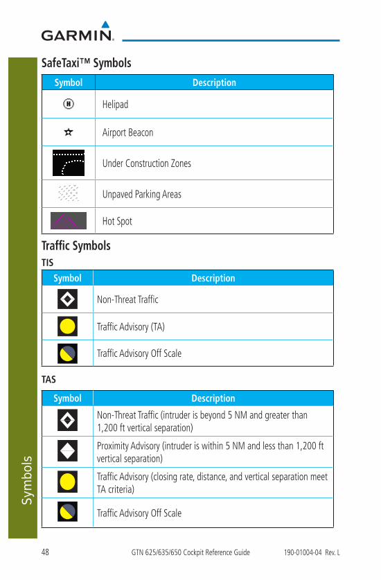
SafeTaxi™ SymbolsSymbol Description
Helipad
Airport Beacon
Under Construction Zones
Unpaved Parking Areas
Hot Spot
Traffic SymbolsTIS
Symbol Description
Non-Threat Traffic
Traffic Advisory (TA)
Traffic Advisory Off Scale
TAS
Symbol Description
Non-Threat Traffic (intruder is beyond 5 NM and greater than 1,200 ft vertical separation)
Proximity Advisory (intruder is within 5 NM and less than 1,200 ft vertical separation)
Traffic Advisory (closing rate, distance, and vertical separation meet TA criteria)
Traffic Advisory Off Scale
49190-01004-04 Rev. L GTN 625/635/650 Cockpit Reference Guide
Symbols
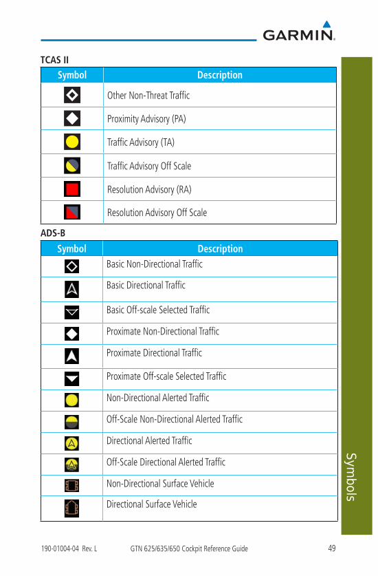
TCAS II
Symbol Description
Other Non-Threat Traffic
Proximity Advisory (PA)
Traffic Advisory (TA)
Traffic Advisory Off Scale
Resolution Advisory (RA)
Resolution Advisory Off Scale
ADS-B
Symbol DescriptionBasic Non-Directional Traffic
Basic Directional Traffic
Basic Off-scale Selected Traffic
Proximate Non-Directional Traffic
Proximate Directional Traffic
Proximate Off-scale Selected Traffic
Non-Directional Alerted Traffic
Off-Scale Non-Directional Alerted Traffic
Directional Alerted Traffic
Off-Scale Directional Alerted Traffic
Non-Directional Surface Vehicle
Directional Surface Vehicle
50 GTN 625/635/650 Cockpit Reference Guide 190-01004-04 Rev. L
Symbols
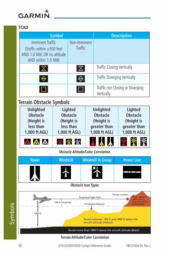
TCAD
Symbol DescriptionImminent Traffic
(Traffic within ±500 feet AND 1.0 NM; OR no altitude
AND within 1.0 NM)
Non-Imminent Traffic
Traffic Closing Vertically
Traffic Diverging Vertically
Traffic not Closing or Diverging Vertically
Terrain Obstacle SymbolsUnlighted Obstacle (Height is less than
1,000 ft AGL)
Lighted Obstacle (Height is less than
1,000 ft AGL)
Unlighted Obstacle (Height is
greater than 1,000 ft AGL)
Lighted Obstacle (Height is
greater than 1,000 ft AGL)
Obstacle Altitude/Color Correlation
Tower Windmill Windmill in Group Power Line
Obstacle Icon Types
Threat Location
Unlighted Obstacle
Projected Flight Path
1000 ft
100 ft Threshold
Terrain more than 1000 ft below the aircraft altitude (Black)
Terrain between 100 ft and 1000 ft below the aircraft altitude (Yellow)
Terrain above or within 100 ft below the aircraftaltitude (Red)
Terrain Altitude/Color Correlation

51190-01004-04 Rev. L GTN 625/635/650 Cockpit Reference Guide
Symbols
HTAWS Obstacle Symbols
Obstacle is at or above the aircraft altitude (Red)
250 ft Obstacle is between 250 ft and 0 ft below the aircraft altitude (Yellow)
Obstacle is 250 ft, or more, below the aircraft altitude (White)
HTAWS Obstacle/Altitude Correlation
Terrain more than 500 ft below the aircraft altitude
Terrain is between 0 ft and 250 ft below the aircraft altitude
Terrain is more than 250 ft above the aircraft altitude
Terrain is between 250 ft and 0 ft above the aircraft altitude
Aircraft Altitude -250 ft
Terrain is between 250 ft and 500 ft below the aircraft altitude
Aircraft Altitude +250 ft
Aircraft Altitude -500 ft
Aircraft Altitude
Red
Orange
Yellow
Green
Black
HTAWS Altitude/Color Correlation
Basemap SymbolsSymbol Description
Interstate Highway
State Highway
US Highway
National Highway - 2-digit drawn inside
Small City or Town
Medium City
Large City

52 GTN 625/635/650 Cockpit Reference Guide 190-01004-04 Rev. L
Symbols
Map Tool Bar Symbols
Symbol Description
Terrain Proximity Enabled and Available Indicator
Terrain Proximity Enabled and Not Available Indicator
Point Obstacle Enabled and Available Indicator (software v5.12 and later)Point Obstacle Enabled and Not Available Indicator (software v5.12 and later)Wire Obstacles Enabled and Available Indicator (software v5.12 and later)Wire Obstacles Enabled and Not Available Indicator (software v5.12 and later)StormScope Enabled
Ownship is receiving TIS-B and ADS-R services (software v5.11 or earlier)Possible incomplete traffic picture – ownship is not receiving one (or both) of the TIS-B or ADS-R services (software v5.11 or earlier)Traffic Enabled and Available Indicator
Traffic Enabled and Not Available Indicator
53190-01004-04 Rev. L GTN 625/635/650 Cockpit Reference Guide
Symbols
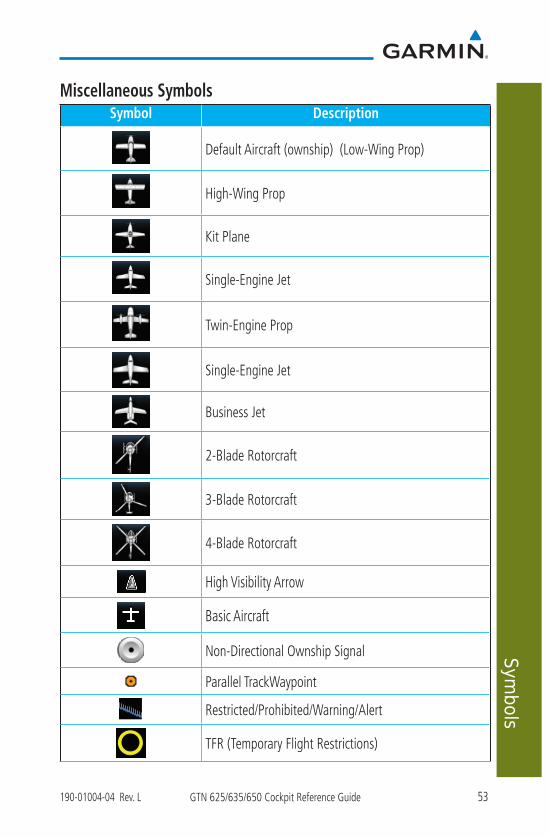
Miscellaneous SymbolsSymbol Description
Default Aircraft (ownship) (Low-Wing Prop)
High-Wing Prop
Kit Plane
Single-Engine Jet
Twin-Engine Prop
Single-Engine Jet
Business Jet
2-Blade Rotorcraft
3-Blade Rotorcraft
4-Blade Rotorcraft
High Visibility Arrow
Basic Aircraft
Non-Directional Ownship Signal
Parallel TrackWaypoint
Restricted/Prohibited/Warning/Alert
TFR (Temporary Flight Restrictions)

54 GTN 625/635/650 Cockpit Reference Guide 190-01004-04 Rev. L
Symbols
Symbol Description
MOA
Class B AirspaceClass C Airspace
Class D Airspace
User Waypoint
Stormscope® SymbolsSymbol Time Since Strike (Seconds)
6
60
120
180

55190-01004-04 Rev. L GTN 625/635/650 Cockpit Reference Guide
Messages
MESSAGESMessage Description Action
ABORT APPROACH - GPS approach no longer available.
This message is triggered outside the MAP if the GTN system can no longer provide approach level of service. Vertical guidance will be removed from the external CDI/HSI display.
Initiate a climb to the MSA or other published safe altitude, abort the approach, and execute a non-GPS based approach.
AIRSPACE ALERT - Airspace entry in less than 10 minutes.
The aircraft is predicted to enter an airspace type, within 10 minutes, for which alerts are configured.
No action is necessary; message is informational only.
AIRSPACE ALERT - Airspace within 2 nm and entry in less than 10 minutes.
The aircraft is within 2 nm and predicted to enter an airspace type, within 10 minutes, for which alerts are configured.
No action is necessary; message is informational only.
AIRSPACE ALERT - Inside airspace.
The aircraft inside an airspace type for which alerts are configured.
No action is necessary; message is informational only.
AIRSPACE ALERT - Within 2 nm of airspace.
The aircraft is within 2nm of an airspace type for which alerts are configured.
No action is necessary; message is informational only.

56 GTN 625/635/650 Cockpit Reference Guide 190-01004-04 Rev. L
Messages Message Description Action
APPROACH DOWNGRADE - Approach downgraded. Use LNAV minima.
Approach has been downgraded from LPV or LNAV/VNAV, to an LNAV approach. Vertical guidance will be removed from the external CDI/HSI display.
Continue to fly the approach using published LNAV minimums.
APPROACH NOT ACTIVE - Do not continue GPS approach.
GPS approach could not transition to active (e.g., the GTN is on an approach and did not have the required HPL/VPL to get into at least LNAV, so is still in TERM).
Abort the approach, and execute a non-GPS based approach.
APR GUIDANCE AVAILABLE - Press “Enable APR Output” before selecting APR on autopilot.
The GTN is configured for KAP140/KFC225 autopilot, and approach guidance is now available.
Press the “Enable APR Output” key on the GTN, this will cause the autopilot to go into ROL mode. Engage the autopilot into approach mode.
CDI/HSI FLAG - Main lateral/vertical flag on CDI/HSI is inoperative.
The Main Lateral Superflag or Main Vertical Superflag output has been turned off due to an over-current condition.
Verify course guidance is valid and correct by crosschecking with the GTN on-screen CDI and other navigational equipment. Contact dealer for service.
CDI SOURCE - Select appropriate CDI source for approach.
Aircraft is on a GPS approach but CDI is set to VLOC, or aircraft is on VLOC approach and CDI is set to GPS and aircraft is less than 2 nm from the FAF.
Select the appropriate CDI source for approach.

57190-01004-04 Rev. L GTN 625/635/650 Cockpit Reference Guide
Messages
Message Description Action
COM RADIO - COM locked to 121.5 MHz. Hold remote COM transfer key to exit.
COM radio is locked to 121.5 MHz.
The external COMremote transfer (COM RMT XFR) switch has been held and the COM radio is tuned to 121.5. To exit this mode, hold the COM remote transfer (COM RMT XFR) switch for two seconds.
COM RADIO - COM overtemp or undervoltage. Reducing transmitter power.
COM radio is in overtemp or undervoltage mode and transmitting power has been reduced to prevent damage to the COM radio. Radio range will be reduced.
Decrease length of COM transmissions, decrease cabin temperature and increase cabin airflow (especially near the GTN). Check aircraft voltage and reduce electrical load as necessary. Contact dealer for service if this message persists.
COM RADIO - COM radio may be inoperative.
The COM radio is not communicating properly with the system.
Press and hold the volume knob or the external COM remote transfer (COM RMT XFR) switch, if installed – this will force the COM radio to 121.5 MHz. Contact dealer for service.
COM RADIO - COM radio needs service.
The COM radio is reporting that it needs service. The COM radio may continue to function.
Cycle the power to the COM radio. Contact dealer for service.
CONFIGURATION - Terrain/TAWS configuration is invalid. GTN needs service.
TAWS is inoperative due to a configuration problem with the GTN. This message will be accompanied by a TER FAIL annunciation.
Contact dealer for service.

58 GTN 625/635/650 Cockpit Reference Guide 190-01004-04 Rev. L
Messages Message Description Action
CONFIGURATION MODULE - GTN configuration module needs service.
The GTN cannot communicate with its configuration module. The GTN may still have a valid configuration.
Contact dealer for service.
COOLING - GTN overtemp. Reducing backlight brightness.
Backlight brightness has been reduced due to high display temperatures. The backlight level will remain high enough to be visible in daylight conditions.
Decrease cabin temperature and increase cabin airflow (especially near the GTN). Contact dealer for service if this message persists.
COOLING FAN - The cooling fan has failed.
The GTN cooling fan is powered, but it is not turning at the desired RPM.
Decrease cabin temperature and increase cabin airflow (especially near the GTN) to prevent damage to the unit. Contact dealer for service.
CROSSFILL ERROR - Crossfill is inoperative. See CRG for crossfilled items.
Crossfill is not working due to loss of communication with other GTN or due to one GTN needing service.
See Pilot’s Guide for a list of crossfilled items that will no longer be crossfilled. Contact dealer for service.
CROSSFILL ERROR - GTN Navigation DB mismatch. See CRG for crossfilled items.
The navigation databases do not match between GTNs resulting in a loss of communication between two units.
Check the specified database version of both GTNs and ensure it is up-to-date. Update the specified database if needed.

59190-01004-04 Rev. L GTN 625/635/650 Cockpit Reference Guide
Messages
Message Description Action
CROSSFILL ERROR - GTN software mismatch. See CRG for crossfilled items.
Crossfill is configured “on” but is not working due to software mismatch.
See Pilot’s Guide for a list of crossfilled items that will no longer be crossfilled. Contact dealer to have software versions updated.
CROSSFILL STATUS - Crossfill is turned off.
Crossfill is turned off. No action.
DATABASE - A procedure has been modified in a cataloged flight plan.
A new database update caused a procedure to be truncated because the flight plan now has too many waypoints or removed a procedure because it no longer exists in the database.
Verify stored cataloged flight plans and procedures. Modify stored flight plans and procedures as necessary to include the current procedures by re-loading those procedures to the stored flight plan routes.
DATABASE - Terrain display unavailable for current location.
The aircraft is outside the terrain database coverage area.
Terrain and TAWS functions will be unavailable. If terrain coverage is desired in the area, load appropriate coverage area on the external datacard.
DATABASE - Terrain or Obstacle database not available.
The terrain or obstacle database is missing or corrupt.
Re-load these databases on the external datacard.
DATABASE - Verify airways in stored flight plans are correct.
A stored flight plan contains an airway that is no longer consistent with the current navigation database.
Verify that the airways in stored flight plans are correct. Modify stored flight plans as necessary to include the current airways by re-loading those airways to the stored flight plan routes.

60 GTN 625/635/650 Cockpit Reference Guide 190-01004-04 Rev. L
Messages Message Description Action
DATABASE - Verify user-modified procedures in stored flight plans are correct.
A stored flight plan contains procedures that have been manually updated, and a navigation database update has occurred.
Verify that the user-modified procedures in stored flight plans are correct.
DATABASE - Terrain database is not installed, is corrupt, or is not valid for this system.
Terrain database is not available. Terrain information and alerts do not display.
Re-load this database on the external datacard.
DATACARD ERROR - SD card is invalid or failed.
External datacard has an error and the unit is not able to read the databases.
ChartView, FlightCharts, and Terrain databases will not be accessible by the unit. Contact dealer for service.
DATACARD REMOVED - Reinsert SD card.
External datacard was removed.
Reinsert datacard.
DATALINK - ADS-B In fault: UAT receiver.
The ADS-B In source has detected a UAT receiver fault.
Contact dealer for service.
DATALINK - ADS-B In fault: 1090 receiver.
The ADS-B In source has detected a 1090 receiver fault.
Contact dealer for service.
DATALINK - FIS-B weather has failed.
The FIS-B receiver is reporting that it has failed. The display of FIS-B products may be unavailable.
Contact dealer for service.

61190-01004-04 Rev. L GTN 625/635/650 Cockpit Reference Guide
Messages
Message Description Action
DATALINK - GDL 69 is inoperative or connection to GTN is lost.
The GTN is configured for a Garmin datalink (GDL 69 or 69A) and the GTN cannot communicate with the datalink. Data from the datalink will not be available.
Contact dealer for service.
DATALINK - GDL 88 ADS-B failure. Unable to transmit ADS-B messages.
GDL 88 is not able to transmit an ADS-B message due to a failure with the GDL 88 system or antenna(s).
Contact dealer for service.
DATALINK - GDL 88 ADS-B fault.
The GDL 88 has detected a fault with one of the GDL 88 UAT/1090 antennas.
Contact dealer for service.
DATALINK - GDL 88 ADS-B fault. Pressure altitude input is invalid.
The GDL 88 has lost communication with the pressure altitude source.
Contact dealer for service.
DATALINK - GDL 88 ADS-B is not transmitting position. Check GPS devices.
The GDL 88 has detected a position input fault.
Contact dealer for service.
DATALINK - GDL 88 configuration module needs service.
The GDL 88 has detected a configuration module fault.
Contact dealer for service.

62 GTN 625/635/650 Cockpit Reference Guide 190-01004-04 Rev. L
Messages Message Description Action
DATALINK - GDL 88 control input fault. Check transponder is in correct mode.
The GDL 88 has lost communication with the transponder.
Contact dealer for service.
DATALINK - GDL 88 is inoperative or connection to GTN is lost.
The GTN is configured for a Garmin datalink (GDL 88) and the GTN cannot communicate with the datalink. Data from the datalink will not be available.
Contact dealer for service.
DATALINK - GDL 88 needs service.
GDL 88 has detected an internal fault.
Contact dealer for service.
DATALINK - GSR 56 data services inoperative; registration required.
The GSR 56 is not registered. GSR Weather, Position Reporting, and Phone Services will be unavailable.
Contact dealer for service.
DATALINK - GSR 56 is inoperative or connection to GTN is lost.
The GTN is configured for a Garmin GSR 56 and the GTN cannot communicate with the GSR 56. GSR Weather, Position Reporting, and Phone Services will be unavailable.
Close the GSR 56 circuit breaker and ensure the GSR 56 is receiving power. Contact dealer for service.
DATA LOST - Pilot stored data was lost. Recheck settings.
User settings such as map detail level, NAV range ring on/off, traffic overlay on/off, and alert settings have been lost.
Recheck settings.
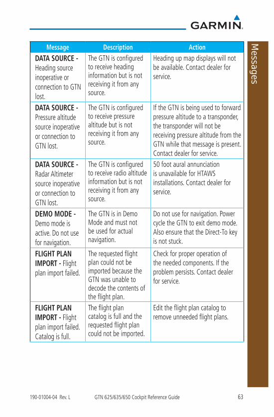
63190-01004-04 Rev. L GTN 625/635/650 Cockpit Reference Guide
Messages
Message Description Action
DATA SOURCE - Heading source inoperative or connection to GTN lost.
The GTN is configured to receive heading information but is not receiving it from any source.
Heading up map displays will not be available. Contact dealer for service.
DATA SOURCE - Pressure altitude source inoperative or connection to GTN lost.
The GTN is configured to receive pressure altitude but is not receiving it from any source.
If the GTN is being used to forward pressure altitude to a transponder, the transponder will not be receiving pressure altitude from the GTN while that message is present. Contact dealer for service.
DATA SOURCE - Radar Altimeter source inoperative or connection to GTN lost.
The GTN is configured to receive radio altitude information but is not receiving it from any source.
50 foot aural annunciation is unavailable for HTAWS installations. Contact dealer for service.
DEMO MODE - Demo mode is active. Do not use for navigation.
The GTN is in Demo Mode and must not be used for actual navigation.
Do not use for navigation. Power cycle the GTN to exit demo mode. Also ensure that the Direct-To key is not stuck.
FLIGHT PLAN IMPORT - Flight plan import failed.
The requested flight plan could not be imported because the GTN was unable to decode the contents of the flight plan.
Check for proper operation of the needed components. If the problem persists. Contact dealer for service.
FLIGHT PLAN IMPORT - Flight plan import failed. Catalog is full.
The flight plan catalog is full and the requested flight plan could not be imported.
Edit the flight plan catalog to remove unneeded flight plans.

64 GTN 625/635/650 Cockpit Reference Guide 190-01004-04 Rev. L
Messages Message Description Action
FLIGHT PLAN IMPORT - New imported flight plan(s) available for preview.
The GTN has received a new flight plan that is available for preview by the pilot.
No action is necessary; message is informational only.
FPL WAYPOINT LOCKED - Stored flight plan waypoint is not in current navigation database.
A stored flight plan waypoint is no longer in the current navigation database.
Verify stored cataloged flight plans and procedures. Modify stored flight plans as necessary to include waypoints that are in the current navigation database.
FPL WPT MOVED - Stored flight plan waypoint has changed location.
A stored flight plan waypoint has moved by more than 0.33 arc minutes from where previously positioned.
Verify stored cataloged flight plans and procedures. Modify stored flight plans as necessary to include waypoints that are in the current navigation database.
GLIDESLOPE - Glideslope receiver has failed.
The glideslope board is not communicating property with the system.
Fly an approach that does not use the glideslope receiver (VOR, LOC, GPS). Contact dealer for service.
GLIDESLOPE - Glideslope receiver needs service.
The glideslope board is indicating that it needs service. The glideslope board may continue to function.
Verify glideslope deviation indications with another source and crosscheck final approach fix crossing altitude. If another glideslope source is not available for verification, fly a GPS based approach. Contact dealer for service.
GNS CROSSFILL - Catalog full; not all GNS waypoint(s) transferred.
A user waypoint from the GNS could not be created because the user waypoint catalog is full.
Remove some of the waypoints from the catalog to make room for the waypoints from the GNS.

65190-01004-04 Rev. L GTN 625/635/650 Cockpit Reference Guide
Messages
Message Description Action
GNS CROSSFILL - GTN user waypoint(s) replaced with GNS user waypoints.
A user waypoint from the GNS replaced one or more existing waypoints on the GTN.
Ensure that the waypoints on the GNS have unique names before transferring to the GTN to avoid overwriting existing waypoints.
GNS CROSSFILL - Waypoint transfer failed.
Waypoint transfer failed/incomplete.
The data transfer should be reattempted.
GPS NAVIGATION LOST - Erroneous position. Use other navigation source.
GPS position has been lost due to erroneous position.
Use a different GPS receiver or a non-GPS based source of navigation. Contact dealer for service.
GPS NAVIGATION LOST - Insufficient satellites. Use other navigation source.
GPS position has been lost due to lack of satellites.
Wait for GPS satellite geometry to improve. Ensure the aircraft has a clear view of the sky. Use a different GPS receiver or a non-GPS based source of navigation. Contact dealer for service.
GPS RECEIVER - GPS receiver has failed. Check GPS coax for electrical short.
Internal communication to the SBAS board is inoperative.
Use a different GPS receiver or a non-GPS based source of navigation. Contact dealer for service.
GPS RECEIVER - GPS receiver needs service.
The GPS module is reporting that it needs service. The GPS module may continue to function.
Use a different GPS receiver or a non-GPS based source of navigation. Contact dealer for service.
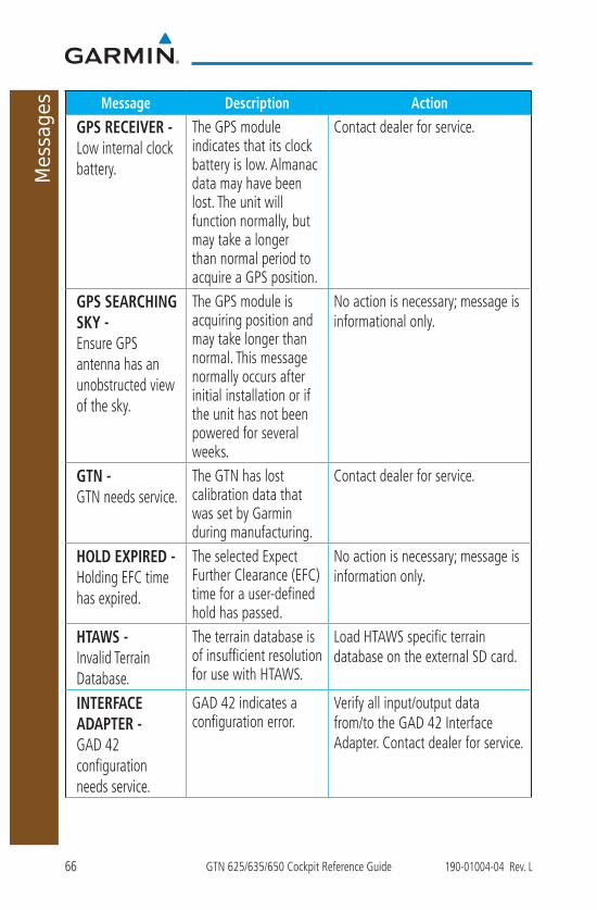
66 GTN 625/635/650 Cockpit Reference Guide 190-01004-04 Rev. L
Messages Message Description Action
GPS RECEIVER - Low internal clock battery.
The GPS module indicates that its clock battery is low. Almanac data may have been lost. The unit will function normally, but may take a longer than normal period to acquire a GPS position.
Contact dealer for service.
GPS SEARCHING SKY - Ensure GPS antenna has an unobstructed view of the sky.
The GPS module is acquiring position and may take longer than normal. This message normally occurs after initial installation or if the unit has not been powered for several weeks.
No action is necessary; message is informational only.
GTN - GTN needs service.
The GTN has lost calibration data that was set by Garmin during manufacturing.
Contact dealer for service.
HOLD EXPIRED - Holding EFC time has expired.
The selected Expect Further Clearance (EFC) time for a user-defined hold has passed.
No action is necessary; message is information only.
HTAWS - Invalid Terrain Database.
The terrain database is of insufficient resolution for use with HTAWS.
Load HTAWS specific terrain database on the external SD card.
INTERFACE ADAPTER - GAD 42 configuration needs service.
GAD 42 indicates a configuration error.
Verify all input/output data from/to the GAD 42 Interface Adapter. Contact dealer for service.

67190-01004-04 Rev. L GTN 625/635/650 Cockpit Reference Guide
Messages
Message Description Action
INTERFACE ADAPTER - GAD 42 needs service.
GAD 42 indicates it needs service. The GAD 42 may continue to function.
Verify all input/output data from/to the GAD 42 Interface Adapter. Contact dealer for service.
INTERNAL SD CARD ERROR - GTN needs service.
Internal SD card has an error. This card is not accessible by the user.
Contact dealer for service.
INTERNAL SD CARD REMOVED - GTN needs service.
Internal SD card was removed or failed. This card is not accessible by the user.
Contact dealer for service.
KEY STUCK - Direct-To key is stuck.
The Direct-To key has been in pressed position for at least 30 seconds. This key will now be ignored.
Verify the Direct-To key is not pressed. Contact dealer for service if this message persists.
KEY STUCK - HOME key is stuck.
The HOME key has been in pressed position for at least 30 seconds. This key will now be ignored.
Verify the HOME key is not pressed. Press the Home key again to cycle its operation. Contact dealer for service if this message persists.
KNOB STUCK - Dual concentric inner knob is stuck in the pressed position.
The dual concentric inner knob has been in pressed position for at least 30 seconds. This knob press will now be ignored.
Verify the dual concentric knob is not pressed. Contact dealer for service if this message persists.
KNOB STUCK - Volume knob is stuck in the pressed position.
The Volume knob has been in pressed position for at least 30 seconds. This knob press will now be ignored.
Verify the volume knob is not pressed. Contact dealer for service if this message persists.

68 GTN 625/635/650 Cockpit Reference Guide 190-01004-04 Rev. L
Messages Message Description Action
LOCKED FLIGHT PLAN Cannot activate a flight plan containing a locked waypoint.
The user is trying to activate a flight plan that contains a locked waypoint.
Unlock the flight plan by modifying stored flight plans as necessary to include waypoints, procedures, and airways that are in the current navigation database.
LOSS OF INTEGRITY (LOI)- Verify GPS position with other navigation equipment.
Antenna may be shaded from satellites. The GPS module has reported a loss of integrity.
Make sure the aircraft is clear of hangars, buildings, trees, etc. Use a different GPS receiver or a non-GPS based source of navigation. Contact dealer for service if this message persists.
MAGNETIC NORTH APPROACH - Verify NAV angles are referenced to magnetic north (magnetic variation).
The NAV angle is not set to Magnetic and a magnetic approach is loaded.
Change NAV angle setting to Magnetic.
MAGNETIC VARIATION - Aircraft in area with large mag var. Verify all course angles.
MagVar is flagged as unreliable in the MagVar database. This normally occurs when operating at high latitudes that do not support a NAV Angle of Magnetic.
Verify that the geographical region supports navigation based on magnetic variation.
MARK ON TARGET - Waypoint creation has failed. MOT requires GPS position.
Mark on target waypoint creation has failed because of missing GPS position.
Wait for GPS satellite geometry to improve. Ensure the aircraft has a clear view of the sky. Reattempt waypoint creation. Contact dealer for service.
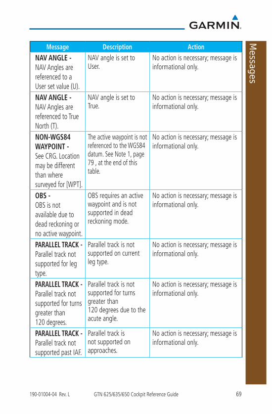
69190-01004-04 Rev. L GTN 625/635/650 Cockpit Reference Guide
Messages
Message Description Action
NAV ANGLE - NAV Angles are referenced to a User set value (U).
NAV angle is set to User.
No action is necessary; message is informational only.
NAV ANGLE - NAV Angles are referenced to True North (T).
NAV angle is set to True.
No action is necessary; message is informational only.
NON-WGS84 WAYPOINT - See CRG. Location may be different than where surveyed for [WPT].
The active waypoint is not referenced to the WGS84 datum. See Note 1, page 79 , at the end of this table.
No action is necessary; message is informational only.
OBS - OBS is not available due to dead reckoning or no active waypoint.
OBS requires an active waypoint and is not supported in dead reckoning mode.
No action is necessary; message is informational only.
PARALLEL TRACK - Parallel track not supported for leg type.
Parallel track is not supported on current leg type.
No action is necessary; message is informational only.
PARALLEL TRACK - Parallel track not supported for turns greater than 120 degrees.
Parallel track is not supported for turns greater than 120 degrees due to the acute angle.
No action is necessary; message is informational only.
PARALLEL TRACK - Parallel track not supported past IAF.
Parallel track is not supported on approaches.
No action is necessary; message is informational only.
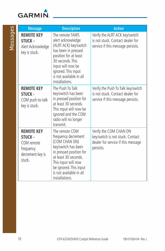
70 GTN 625/635/650 Cockpit Reference Guide 190-01004-04 Rev. L
Messages Message Description Action
REMOTE KEY STUCK - Alert Acknowledge key is stuck.
The remote TAWS alert acknowledge (ALRT ACK) key/switch has been in pressed position for at least 30 seconds. This input will now be ignored. This input is not available in all installations.
Verify the ALRT ACK key/switch is not stuck. Contact dealer for service if this message persists.
REMOTE KEY STUCK - COM push-to-talk key is stuck.
The Push To Talk key/switch has been in pressed position for at least 30 seconds. This input will now be ignored and the COM radio will no longer transmit.
Verify the Push To Talk key/switch is not stuck. Contact dealer for service if this message persists.
REMOTE KEY STUCK - COM remote frequency decrement key is stuck.
The remote COM frequency decrement (COM CHAN DN) key/switch has been in pressed position for at least 30 seconds. This input will now be ignored. This input is not available in all installations.
Verify the COM CHAN DN key/switch is not stuck. Contact dealer for service if this message persists.

71190-01004-04 Rev. L GTN 625/635/650 Cockpit Reference Guide
Messages
Message Description Action
REMOTE KEY STUCK - COM remote frequency increment key is stuck.
The remote COM frequency increment (COM CHAN UP) key/switch has been in pressed position for at least 30 seconds. This input will now be ignored. This input is not available in all installations.
Verify the COM CHAN UP key/switch is not stuck. Contact dealer for service if this message persists.
REMOTE KEY STUCK - COM remote transfer key is stuck.
The remote COM transfer (COM RMT XFR) key/switch has been in pressed position for at least 30 seconds. This input will now be ignored. This input is not available in all installations.
Verify the COM RMT XFR key/switch is not stuck. Contact dealer for service if this message persists.
REMOTE KEY STUCK - NAV remote transfer key is stuck.
The remote NAV transfer (NAV RMT XFR) key/switch has been in pressed position for at least 30 seconds. This input will now be ignored. This input is not available in all installations.
Verify the NAV RMT XFR key/switch is not stuck. Contact dealer for service if this message persists.

72 GTN 625/635/650 Cockpit Reference Guide 190-01004-04 Rev. L
Messages Message Description Action
REMOTE KEY STUCK - Pilot/Co-Pilot voice command push-to-command key is stuck.
The remote push-to-command key/switch has been in pressed position for at least 30 seconds. This input will now be ignored. This input is not available in all installations.
Verify the push-to-command key/switch is not stuck. Contact dealer for service if this message persists.
REMOTE KEY STUCK - Remote CDI key is stuck.
The remote CDI (CDI SRC SEL) key/switch has been in pressed position for at least 30 seconds. This input will now be ignored. This input is not available in all installations.
Verify the CDI SRC SEL key/switch is not stuck. Contact dealer for service if this message persists.
REMOTE KEY STUCK - Remote go around key is stuck.
The remote go around (RMT GO ARND) key/switch has been in pressed position for at least 30 seconds. This input will now be ignored. This input is not available in all installations.
Verify the RMT GO ARND key/switch is not stuck. Contact dealer for service if this message persists.
REMOTE KEY STUCK - Remote OBS key is stuck.
The remote OBS (OBS MODE SEL) key/switch has been in pressed position for at least 30 seconds. This input will now be ignored. This input is not available in all installations.
Verify the OBS MODE SEL key/switch is not stuck. Contact dealer for service if this message persists.
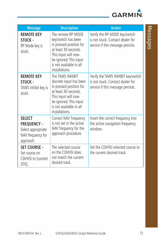
73190-01004-04 Rev. L GTN 625/635/650 Cockpit Reference Guide
Messages
Message Description Action
REMOTE KEY STUCK - RP Mode key is stuck.
The remote RP MODE key/switch has been in pressed position for at least 30 seconds. This input will now be ignored. This input is not available in all installations.
Verify the RP MODE key/switch is not stuck. Contact dealer for service if this message persists.
REMOTE KEY STUCK - TAWS inhibit key is stuck.
The TAWS INHIBIT discrete input has been in pressed position for at least 30 seconds. This input will now be ignored. This input is not available in all installations.
Verify the TAWS INHIBIT key/switch is not stuck. Contact dealer for service if this message persists.
SELECT FREQUENCY - Select appropriate NAV frequency for approach.
Correct NAV frequency is not set in the active NAV frequency for the approach procedure.
Insert the correct frequency into the active navigation frequency window.
SET COURSE - Set course on CDI/HSI to [current DTK].
The selected course on the CDI/HSI does not match the current desired track.
Set the CDI/HSI selected course to the current desired track.

74 GTN 625/635/650 Cockpit Reference Guide 190-01004-04 Rev. L
Messages Message Description Action
STEEP TURN - Aircraft may overshoot course during turn.
Flight plan contains an acute course change ahead which will require a bank in excess of normal to follow the guidance. If coupled to the autopilot, the autopilot may not be able to execute the steep turn needed to follow the course guidance.
No action is necessary; message is informational only. If desired, slow the aircraft to shallow the turn.
STORMSCOPE - Invalid heading received from StormScope.
The WX-500 StormScope reports that it has an invalid heading source.
GTN StormScope data is correct and may be used. Contact dealer for service.
STORMSCOPE - StormScope is inoperative or connection to GTN is lost.
The GTN is configured for a WX-500 StormScope but is not receiving data from it.
Close the Stormscope circuit breaker and ensure Stormscope is receiving power. Contact dealer for service.
TAWS AUDIO INHIBITED - TAWS audio inhibit input is stuck.
The TAWS Audio Inhibit discrete input has been active for at least 30 seconds. This input is active in all installations. TAWS audio may be heard at the same time as other audio alerts.
Contact dealer for service.
TIMER - Timer has expired.
A user-configured timer has expired.
No action is necessary; message is informational only.

75190-01004-04 Rev. L GTN 625/635/650 Cockpit Reference Guide
Messages
Message Description Action
TRAFFIC - ADS-B In traffic alerting has failed.
The ADS-B traffic system is reporting to the GTN that the CSA application has failed. Traffic alerting on ADS-B traffic is unavailable.
Ensure the aircraft has a clear view of the sky. If the problem persists. Contact dealer for service.
TRAFFIC - ADS-B In traffic has failed.
The ADS-B traffic system may have lost GPS position or detected an internal fault.
Contact dealer for service.
TRAFFIC - TCAD has a low battery.
The GDL 88 is reporting that the external traffic system has a low battery.
Contact dealer for service.
TRAFFIC - Traffic device battery low. Traffic device user config settings not saved.
The TCAD system has indicated that its battery is low.
Contact dealer for service.
TRAFFIC - Traffic device has been in standby for more than 60 seconds.
The GTN is airborne and the traffic device has been in standby for more than 60 seconds.
Set the traffic device to “operate” on the traffic page if traffic alerts are desired.
TRAFFIC - Traffic device is inoperative or connection to GTN is lost.
The GTN is configured for a traffic device but is not receiving data from it. Traffic will not be displayed on the GTN.
Contact dealer for service.

76 GTN 625/635/650 Cockpit Reference Guide 190-01004-04 Rev. L
Messages Message Description Action
TRANSPONDER - Transponder 1 and 2 Mode S addresses do not match.
The GTN is configured for two transponders and their Mode S addresses do not match. This message is intended to assist installers and will not occur in a properly configured system.
Contact dealer for service.
TRANSPONDER 1 OR 2 - ADS-B is not transmitting position.
The transponder has insufficient data to support ADS-B.
Ensure the aircraft has a clear view of the sky. Contact dealer for service.
TRANSPONDER 1 OR 2 - ADS-B Out system fault. Pressure altitude source inoperative or connection lost.
The transponder has lost communication with the pressure altitude source.
Contact dealer for service.
TRANSPONDER 1 OR 2 - Transponder 1 or 2 is inoperative or connection to GTN is lost.
The GTN is configured for transponder 1 or 2 but is not able to communicate with the transponder.
Verify squawk code and altitude with ATC. Contact dealer for service.
TRANSPONDER 1 OR 2 - Transponder 1 or 2 needs service.
The transponder is reporting to the GTN that it needs service. The transponder may continue to function.
Verify squawk code and altitude with ATC. Contact dealer for service.

77190-01004-04 Rev. L GTN 625/635/650 Cockpit Reference Guide
Messages
Message Description Action
TRANSPONDER 1 OR 2 - Transponder has failed.
The transponder has detected an internal fault and transponder functionality may be unavailable.
Contact dealer for service.
TRANSPONDER 1 OR 2 - Transponder is in ground test mode.
The transponder is operating in a mode intended for ground testing.
Cycle the power to the transponder.
TRANSPONDER 1 OR 2 - Transponder overtemp.
The transponder is reporting that its internal temperature has exceeded upper operating limits.
Decrease temperature and increase airflow near the transponder, if possible. Monitor aircraft electrical indications. Contact dealer for service if this message persists.
TRANSPONDER 1 OR 2 - Transponder undertemp.
The transponder is reporting that its internal temperature has exceeded lower operating limits.
Contact dealer for service if this message persists.
TRUE NORTH APPROACH - Verify NAV Angles are referenced to True North (T).
A procedure is loaded that is referenced to true north and the active leg has a published true north reference.
Verify the NAV Angle is set to True North.
USER WAYPOINT IMPORT - User waypoints were imported successfully.
All user waypoints were imported successfully.
No action is necessary; message is informational only.
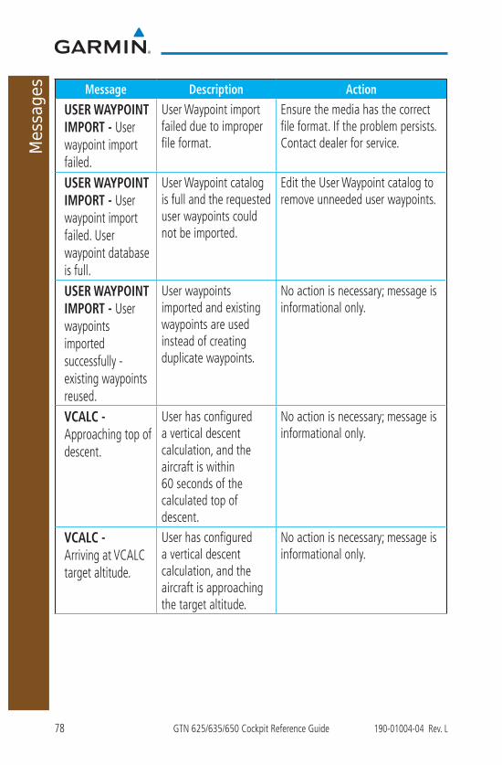
78 GTN 625/635/650 Cockpit Reference Guide 190-01004-04 Rev. L
Messages Message Description Action
USER WAYPOINT IMPORT - User waypoint import failed.
User Waypoint import failed due to improper file format.
Ensure the media has the correct file format. If the problem persists. Contact dealer for service.
USER WAYPOINT IMPORT - User waypoint import failed. User waypoint database is full.
User Waypoint catalog is full and the requested user waypoints could not be imported.
Edit the User Waypoint catalog to remove unneeded user waypoints.
USER WAYPOINT IMPORT - User waypoints imported successfully - existing waypoints reused.
User waypoints imported and existing waypoints are used instead of creating duplicate waypoints.
No action is necessary; message is informational only.
VCALC - Approaching top of descent.
User has configured a vertical descent calculation, and the aircraft is within 60 seconds of the calculated top of descent.
No action is necessary; message is informational only.
VCALC - Arriving at VCALC target altitude.
User has configured a vertical descent calculation, and the aircraft is approaching the target altitude.
No action is necessary; message is informational only.

79190-01004-04 Rev. L GTN 625/635/650 Cockpit Reference Guide
Messages
Message Description Action
VISUAL APPROACH NOT ACTIVE - Approach guidance not available when requesting Direct-To runway.
Visual approach could not transition to active. Guidance is not available.
Reactivate the approach or cancel the Direct-To course.
VLOC RECEIVER - Navigation receiver has failed.
The NAV radio is not communicating property with the system.
Use GPS based navigation. Contact dealer for service.
VLOC RECEIVER - Navigation receiver needs service.
The NAV radio is reporting to the GTN that it needs service. The NAV radio may continue to function.
Use GPS based navigation. Contact dealer for service.
WAYPOINT - Arriving at [wpt name].
User has configured the arrival alarm and is within the specified distance.
No action is necessary; message is informational only.
Note 1: There are several reference datums that waypoints can be surveyed against. TSO-C146 normally requires that all waypoints be referenced to the WGS84 datum, but allows for navigation to waypoints that are not referenced to the WGS84 datum so long as the pilot is notified. Certain waypoints in the navigation database are not referenced to the WGS84 datum, or their reference datum is unknown. If this is the case, this message is displayed. Garmin cannot determine exactly how close the non-WGS84 referenced waypoint will be to the WGS84 datum that the GTN uses. Typically, the distance is within two nautical miles. The majority of non-WGS84 waypoints are located outside of the United States.
80 GTN 625/635/650 Cockpit Reference Guide 190-01004-04 Rev. L
Glov
e Qu
alifi
catio
n Pr
oced
ure
GLOVE QUALIFICATION PROCEDUREThis procedure is used to qualify a specific glove for use with the GTN system
by guiding the user through a variety of tasks that use the touchscreen. Due to differences in finger size, glove size, and touchscreens between the 6XX or 7XX unit, the qualification granted by this procedure is specific to the pilot/glove and 6XX or 7XX combination. GTN 7XX and 6XX units must be evaluated separately.
The GTN touchscreen uses capacitive touch technology to sense the proximity of skin to the display. A glove increases the distance between skin and the display glass and may reduce the ability of the GTN to detect touches. Therefore, when selecting a glove for use with the GTN, thinner gloves tend to work better than thicker gloves. Leather gloves and gloves designed to work specifically with capacitive touchscreen devices are often found to be acceptable. Additionally, altering your touch technique to use the pad of your finger to touch the unit rather than the tip will increase the touchscreen sensitivity while using gloves.
This qualification must be completed on the ground. Performing this procedure in flight is not authorized. “Tests Required for Glove Qualification” table contains tasks that are required to qualify a glove. “Test Not Required for Glove Qualification” table contains tasks that are not required to qualify a glove, but may limit the manner in which some functions are accessed while a glove is worn.
1. Sit in the pilot’s seat. 2. Start the GTN in Demo mode by pressing and holding the Direct To key
during power up.3. Perform the tasks listed in the following sections with an ungloved hand.
You do not need to record any results for this step.4. Perform the tasks listed in the following sections with a gloved hand. For
each task, determine whether the operation is the same or worse as it was without the glove. Record the results in the applicable table. Items that may cause the operation to be worse include, but are not limited to:
a. Multiple attempts to select a keyb. Unintentional selection of adjacent keysc. Excessive force on the touchscreen to select a key
5. If all applicable tasks in following sections respond in the same way with and without a glove then the glove used to complete these tasks may be used by the pilot who performed this evaluation on the unit (6XX or 7XX) that was used during this procedure.

81190-01004-04 Rev. L GTN 625/635/650 Cockpit Reference Guide
Glove Qualification Procedure
Pilot:
Glove Description:
GTN (circle one): 6XX or 7XX
Tests Required for Glove Qualification Task Operation With Glove
(circle one)Navigate to the Home Screen . NATouch the Demo key. Same WorseTouch the GPS key. Same WorseTouch the Waypoint key. Same WorseType “KSLE” using the touchscreen, then touch Enter.
Same Worse
Navigate to the Home Screen (Press HOME). NATouch the Flight Plan key. Same WorseEnter the following waypoints using the Add Waypoint key at the bottom of the list of flight plan waypoints: KSLE KMMVKONPBTG
Same Worse
Select BTG, then touch the Load Airway key to load the following airway: V23 ALFOR.
Same Worse
While viewing the flight plan page, touch the Up/Down arrow keys to scroll up and down to view the flight plan waypoints.
Same Worse
Touch the Back key to return to the Home Screen. Same WorseTouch the COM standby frequency to activate the COM frequency entry keypad (Task applicable to 635/650/750 only).
Same Worse
Enter a valid COM frequency and touch the Enter key (635/650/750 only).
Same Worse

82 GTN 625/635/650 Cockpit Reference Guide 190-01004-04 Rev. L
Glov
e Qu
alifi
catio
n Pr
oced
ure
Task Operation With Glove(circle one)
Touch the active COMfrequency to flip/flop the COMfrequencies. (635/650/750 only).
Same Worse
Touch the active NAV frequency to flip/flop the NAV frequencies (750 only).
Same Worse
Touch the Menu key (650 only). Same Worse
Tests Not Required for Glove QualificationTask Operation With Glove
(circle one)Navigate to the flight plan page. NAWhile viewing the flight plan page, touch the list and drag up/down to view the flight plan waypoints.
Same Worse
While viewing the flight plan page, touch and flick the list to view the flight plan waypoints.
Same Worse
Navigate to the map page. NATouch the Map to enter Pan mode, then touch the Graphically Edit FPL key.
Same Worse
Remove KONP from the flight plan graphically by touching KONP and dragging it to an area without any waypoints (Pan and zoom in/out as necessary to accomplish the task).
Same Worse
Insert KSPB between KMMV and BTG by dragging the leg between KMMV and BTG to KSPB.
Same Worse

83190-01004-04 Rev. L GTN 625/635/650 Cockpit Reference Guide
Telligence Voice Comm
and Qualification Procedure
TELLIGENCE VOICE COMMAND QUALIFICATION PROCEDURE
In order to enable voice command functionality crew members must successfully perform and complete 17/20 (85%) voice commands in the Telligence aircraft qualification procedure. Crew members must be comfortable speaking into an aviation headset and proficient in English.
Voice Command Guidelines
NOTE: If a voice command is uninterpretable, verify the system is performing the intended action or displaying the desired data. If the system does not recognize a command, use the touchscreen to execute the function. The GTN Voice Command History details all commands performed.
• Position the headset MIC approximately 1/8-inch from mouth, align with bottom lip to avoid breath sounds in the microphone.
• Speak conversationally.
• Enunciate.
• Speak in a normal tone and volume.
• Speak at a normal cadence (not too quickly or slowly).
• Pause briefly between activation of the Push to Command (PTC) switch and when speaking the voice command.
• Review the commands prior to performing the qualification.
84 GTN 625/635/650 Cockpit Reference Guide 190-01004-04 Rev. L
Telli
genc
e Vo
ice
Com
man
d Qu
alifi
catio
n Pr
oced
ure
Voice Command Instructions 1. Press and hold the PTC switch.
2. Speak the entire command into the headset MIC.
3. Release the PTC switch.
• A positive tone (low-to-high) indicates the command has been recognized and executed. (i.e., page changed, radio tuned, MIC selected, etc.)
• A negative tone (high-to-low) indicates the command is either unrecognizable or invalid.
Successful Command Example
“Show approaches page” is spoken, the approach selection page displays
immediately, and a positive tone sounds.
Unsuccessful Command Example
“Show map page” is spoken and the traffic page displays.
“Show map page” is spoken and a negative tone sounds.
Qualification ProcedureSpeak the unbold phrase if the voice command in this procedure is not
applicable to the aircraft’s configuration. If the total number of successful commands is less than 17, the voice commands must be disabled. For instructions on how to activate and deactivate voice commands, refer to the GTN 625/635/650 Pilot’s Guide, P/N 190-01004-03.
Example: If the requirement states a COM radio is required, but your GTN does not a have a COM radio, use the unbold command.
1. Start the GTN and acquire a GPS position.
2. Conduct the voice commands in sequential order while wearing an aviation headset. If necessary, a command can be attempted twice.
3. When the command is successful check the box next to the command.

85190-01004-04 Rev. L GTN 625/635/650 Cockpit Reference Guide
Telligence Voice Comm
and Qualification Procedure
SHOW Flight Plan PAGE
*** Manually enter a flight plan with a towered airport as the destination ***
SHOW Trip Planning PAGE
* TUNE Nearest Ground or SHOW Nearest Airport PAGE
* TUNE Nearest ATIS or SHOW Nearest Weather Frequency PAGE
† TOGGLE COM 2 or SAY Distance
SHOW Map PAGE
ZOOM OUT
SAY Distance to Destination
SHOW Flight Timers PAGE
† SELECT COM 2 or SAY ETA at Destination
SAY Active Waypoint
CREATE Waypoint Here
* TUNE Destination Tower or SHOW Destination Runways PAGE
‡ SHOW Traffic PAGE or SHOW Nearest PAGE
SHOW Procedures PAGE
SHOW V-CALC PAGE
SHOW Current Time
SAY Desired Track
BACK
SHOW Voice Command History Page
* A GTN COM radio is required.
† Two COM radios connected to the GMA are required.
‡ Traffic capability is required on the GTN.

86 GTN 625/635/650 Cockpit Reference Guide 190-01004-04 Rev. L
This page intentionally left blank


© 2011 - 2017 Garmin Corporation
www.flyGarmin.com
At Garmin, we value your opinion. For comments about this guide, please e-mail: [email protected]
To obtain accessories for your unit, please contact your Garmin dealer.
Except as expressly provided herein, no part of this manual may be reproduced, copied, transmitted, disseminated, downloaded or stored in any storage medium, for any purpose without the express written permission of Garmin. Garmin hereby grants permission to download a single copy of this manual and of any revision to this manual onto a hard drive or other electronic storage medium to be viewed for personal use, provided that such electronic or printed copy of this manual or revision must contain the complete text of this copyright notice and provided further that any unauthorized commercial distribution of this manual or any revision hereto is strictly prohibited. This part shall comply with Garmin Banned and Restricted Substances document, 001-00211-00.
Garmin®, FliteCharts®, and SafeTaxi® are registered trademarks of Garmin Ltd. or its subsidiaries. Garmin SVT™ is a trademark of Garmin Ltd. or its subsidiaries. These trademarks may not be used without the express permission of Garmin.
NavData® is a registered trademark of Jeppesen, Inc.; StormScope® and SkyWatch® are registered trademarks of L-3 Communications; Sirius and XM are trademarks of SiriusXM Radio Inc.; Iridium® is a registered trademark of Iridium Communications Inc.; United States radar data provided by NOAA; European radar data collected and provided by Meteo France. SD and SDHC Logos are trademarks of SD-3C, LLC; the Bluetooth® word mark and logos are registered trademarks owned by Bluetooth SIG, Inc. and any use of such marks by Garmin is under license.
AC 90-100A Statement of Compliance: The Garmin navigational unit meets the performance and functional requirements of FAA Advisory Circular (AC) 90-100A, U.S. Terminal and En Route Area Navigation (RNAV) Operations.
August 2017 Part Number 190-01004-04 Rev. L


