19
EDINA JÓZSA1, SZABOLCS ÁKOS FÁBIÁN2 (PÉCS)
MAPPING LANDFORMS AND GEOMORPHOLOGICAL LANDSCAPES
OF HUNGARY USING GIS TECHNIQUES
Abstract. Modern geomorphological analyses largely benefit from GIS tools developed for landform
and landscape mapping. Semi-automated methods with the use of public domain elevation datasets
ensure the mapping of large areas with relatively low time and cost requirements, leaving less space
for subjectivity. For our analysis we chose the geomorphons approach, a robust cell-based method
to identify landform elements at a broad range of scales. Based on the delineated landforms and
auxiliary morphometric parameters it was possible to map the geomorphological landscapes oc-
curring in Hungary with the supervised classification algorithm implemented in the GeoPAT toolset.
The scientific output of the presented work is twofold: one aspect is the creation of an objective and
quantifiable map of landforms and geomorphic landscapes of Hungary, while the successful appli-
cation of the available methodology and the evaluation of SRTM1 model’s applicability for geomor-
phological purposes are also significant results.
Keywords: digital geomorphological mapping, geomorphometry, semi-automated GIS algorithm,
SRTM1, Hungary
INTRODUCTION AND AIMS
Since digital elevation models provide snapshots of the landscape with
constantly improving horizontal and vertical resolutions and GIScience became
widely used Digital Geomorphological Mapping (DGM) is no longer an unorth-
odox geographical research subject (H e g e d ű s 2004; M i n á r, E v a n s 2008;
Te l b i s z 2009; B i s h o p et al. 2012; D r ă g u , E i s a n k 2012; E v a n s 2012;
J a s i e w i c z, S t e p i n s k i 2013). Based on the scientific results of the recent
years it can be stated that the improvement in applicability of GIS software, ter-
rain modelling methods and satellite-based elevation data led to irreversible
changes in the nature of geomorphological research and mapping, considering
data collection, analysis and presentation mode as well (S m i t h et al. eds. 2011).
Terrain analysis toolsets ensure the mapping of large areas with relatively low
time and cost requirements, leaving less space for subjectivity and due to the
application of rulesets the resulting maps can be easily upgraded (D r ă g u ,
B l a s c h k e 2006; v a n A s s e l e n, S e i j m o n s b e r g e n 2006). According to
S T U D I A G E O M O R P H O L O G I C A C A R P A T H O - B A L C A N I C A
Vol. L, 2016: 19–31 PL ISSN 0081-6434
20
several authors the development of readily adaptable, semi-automated methods
for landform delineation and landscape mapping became the most prosperous
subdivision of geomorphometry (P i k e et al. 2009; D r ă g u , E i s a n k 2011).
Based on the absolute altitudes and relative elevation differences Hunga-
ry can be divided into three height levels, or so called relief steps: lowlands,
hills and low mountains (B u l l a 1962). Approx. 20-20% of the country is char-
acterized by mountainous and hilly environments, accordingly its major area
belongs to plains (P é c s i 1984). On the other hand, F. S c h w e i t z e r (2009)
claims that 73% of the area is considered as plains, 20% belongs to hills and
pediment surfaces and only 7% can be categorized as mountainous. Different
authors discriminate different subtypes, and while these broadly coincide, their
spatial delineation or exact categorization typically varies. Exclusively on the
basis of orographic and morphologic conditions the authors describe the moun-
tainous regions as medium and low mountains with narrower and wider ridges;
they discriminate between hills in mountain forelands and isolated hilly districts
characterised by erosion-derasion valleys; while separating lowlands into the
categories of flat floodplains and gently undulating alluvial plains, which are in
some cases heightened by loess or sand cover (P r i n z 1936; B u l l a 1962; P é c s i,
S o m o g y i 1967; P é c s i 1977, 1984, 1996; S c h w e i t z e r 2009; L ó c z y 2015).
In the present study, we divided each major relief type into two subtypes of geo-
morphic landscapes.
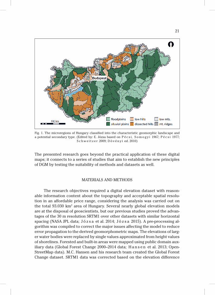
The largest units of the hierarchic landscape system of Hungary are the
macroregions i.e. Great Hungarian Plain (GHP), Little Hungarian Plain (LHP),
West Hungarian Borderland (WHB), Transdanubian Hills (TDH), Transdanubian
Range (TDR), North Hungarian Range (NHR), which are territories with natural
conditions significantly differing from their neighbouring regions and reflect the
conditions of the geomorphic regions as well (M é s z á r o s, S c h w e i t z e r eds.
2002). Based on the spatial arrangement and connection of the natural factors
there are 33 mezoregions and 230 microregions with a more homogenous land-
scape potential on the lower levels of the system (M a r o s i, S o m o g y i eds.
1990; D ö v é n y i ed. 2010). As the microregions are most commonly chosen to
be the base unit of analysis in researches related to earth sciences and the geo-
morphological and relief type maps were in some cases incomplete or incompat-
ible, we decided to classify the microregions based on their characteristic geo-
morphic landscape (Fig. 1). We could do so because in the delineation process
of these microregions the morpho-lithological elements, geostructural features
and orographical conditions provided the frame of the landscapes’ regionaliza-
tion (P é c s i 1984).
The main objective of the research was a geomorphological characterisa-
tion of the terrain in Hungary based on a public domain height dataset using
GIS algorithms. The landform map and the derived geomorphological landscape
map reveal objective information about the spatial arrangement and characteris-
tics of the topography in order to revise the traditional geomorphological maps.
21
The presented research goes beyond the practical application of these digital
maps; it connects to a series of studies that aim to establish the new principles
of DGM by testing the suitability of methods and datasets as well.
MATERIALS AND METHODS
The research objectives required a digital elevation dataset with reason-
able information content about the topography and acceptable spatial resolu-
tion in an affordable price range, considering the analysis was carried out on
the total 93.030 km2 area of Hungary. Several nearly global elevation models
are at the disposal of geoscientists, but our previous studies proved the advan-
tages of the 30 m resolution SRTM1 over other datasets with similar horizontal
spacing (NASA JPL data; J ó z s a et al. 2014; J ó z s a 2015). A pre-processing al-
gorithm was compiled to correct the major issues affecting the model to reduce
error propagation to the derived geomorphometric maps. The elevations of larg-
er water bodies were replaced by single values approximated from height values
of shorelines. Forested and built-in areas were mapped using public domain aux-
iliary data (Global Forest Change 2000–2014 data; H a n s e n et al. 2013; Open-
StreetMap data). M.C. Hansen and his research team created the Global Forest
Change dataset. SRTM1 data was corrected based on the elevation difference
Fig. 1. The microregions of Hungary classified into the characteristic geomorphic landscape and
a potential secondary type. (Edited by: E. Józsa based on P é c s i, S o m o g y i 1967; P é c s i 1977;
S c h w e i t z e r 2009; D ö v é n y i ed. 2010)
22
of cells located on the inner and outer border of these land cover units. Lastly,
an adaptive smoothing algorithm (S t e v e n s o n et al. 2010) was implemented
to reduce the effect of noise and remove the outliers.
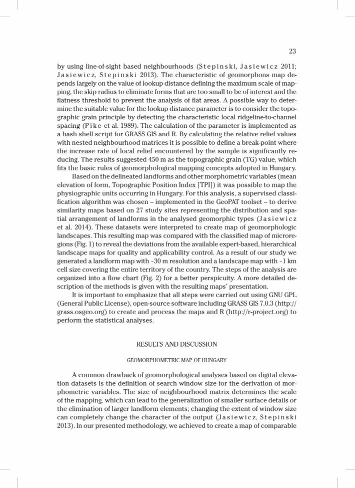
The methods of DEM-based geomorphometric mapping are constantly de-
veloping into the direction of multi-scale landform delineation and the classifica-
tion of landscapes. For our analysis, we chose the geomorphons approach, a ro-
bust cell-based method to identify landform elements at a broad range of scales
Fig. 2. Flowchart of the landform and geomorphological landscape mapping procedure.
(Edited by: E. Józsa)
23
by using line-of-sight based neighbourhoods (S t e p i n s k i, J a s i e w i c z 2011;
J a s i e w i c z, S t e p i n s k i 2013). The characteristic of geomorphons map de-
pends largely on the value of lookup distance defining the maximum scale of map-
ping, the skip radius to eliminate forms that are too small to be of interest and the
flatness threshold to prevent the analysis of flat areas. A possible way to deter-
mine the suitable value for the lookup distance parameter is to consider the topo-
graphic grain principle by detecting the characteristic local ridgeline-to-channel
spacing (P i k e et al. 1989). The calculation of the parameter is implemented as
a bash shell script for GRASS GIS and R. By calculating the relative relief values
with nested neighbourhood matrices it is possible to define a break-point where
the increase rate of local relief encountered by the sample is significantly re-
ducing. The results suggested 450 m as the topographic grain (TG) value, which
fits the basic rules of geomorphological mapping concepts adopted in Hungary.
Based on the delineated landforms and other morphometric variables (mean
elevation of form, Topographic Position Index [TPI]) it was possible to map the
physiographic units occurring in Hungary. For this analysis, a supervised classi-
fication algorithm was chosen – implemented in the GeoPAT toolset – to derive
similarity maps based on 27 study sites representing the distribution and spa-
tial arrangement of landforms in the analysed geomorphic types (J a s i e w i c z
et al. 2014). These datasets were interpreted to create map of geomorphologic
landscapes. This resulting map was compared with the classified map of microre-
gions (Fig. 1) to reveal the deviations from the available expert-based, hierarchical
landscape maps for quality and applicability control. As a result of our study we
generated a landform map with ~30 m resolution and a landscape map with ~1 km
cell size covering the entire territory of the country. The steps of the analysis are
organized into a flow chart (Fig. 2) for a better perspicuity. A more detailed de-
scription of the methods is given with the resulting maps’ presentation.
It is important to emphasize that all steps were carried out using GNU GPL
(General Public License), open-source software including GRASS GIS 7.0.3 (http://
grass.osgeo.org) to create and process the maps and R (http://r-project.org) to
perform the statistical analyses.
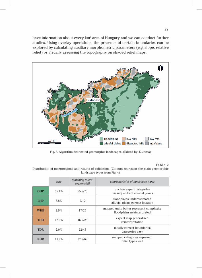
RESULTS AND DISCUSSION
GEOMORPHOMETRIC MAP OF HUNGARY
A common drawback of geomorphological analyses based on digital eleva-
tion datasets is the definition of search window size for the derivation of mor-
phometric variables. The size of neighbourhood matrix determines the scale
of the mapping, which can lead to the generalization of smaller surface details or
the elimination of larger landform elements; changing the extent of window size
can completely change the character of the output (J a s i e w i c z, S t e p i n s k i
2013). In our presented methodology, we achieved to create a map of comparable
24
landform units by using the Topographic Grain value as search parameter in the
geomorphons mapping approach.
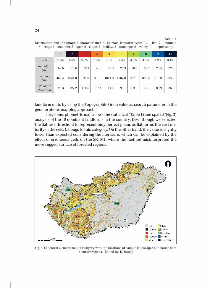
The geomorphometric map allows the statistical (Table 1) and spatial (Fig. 3)
analysis of the 10 dominant landforms in the country. Even though we selected
the flatness threshold to represent only perfect plains as flat forms the vast ma-
jority of the cells belongs to this category. On the other hand, the value is slightly
lower than expected considering the literature, which can be explained by the
effect of erroneous cells on the SRTM1, where the method misinterpreted the
more rugged surface of forested regions.
Table 1
Distribution and topographic characteristics of 10 main landform types. (1 – flat, 2 – summit,
3 – ridge, 4 – shoulder, 5 – spur, 6 – slope, 7 – hollow, 8 – footslope, 9 – valley, 10 – depression)
1 2 3 4 5 6 7 8 9 10
rate 52.3% 0.6% 5.0% 3.9% 6.1% 17.6% 4.5% 4.7% 4.9% 0.4%
min elev.
(m)69.6 73.6 72.3 71.0 32.3 29.9 28.9 69.7 23.5 22.6
max elev.
(m)462.4 1044.0 1031.8 831.0 1021.8 1007.8 997.6 819.4 919.0 885.5
standard
deviation25.3 127.2 110.6 37.4 111.4 93.1 103.5 35.1 88.9 86.6
Fig. 3. Landform element map of Hungary with the locations of sample landscapes and boundaries
of macroregions. (Edited by: E. Józsa)
25
The raster map holding the landform elements provides the opportunity
to visually analyse the characteristics of a given topography, but more impor-
tantly the dataset allows the automatic separation of landscapes by following
a predefined set of rules. To get a good representation about the varying topo-
graphic characteristics of the analysed geomorphic landscape types we select-
ed 4–5 sample sites per type scattered throughout the country (Figs. 3 and 4).
The landform elements of plains show a well distinguishable pattern, even
though the effect of surface objects and remaining errors of the SRTM1 are visi-
ble. Due to the small range of altitudes occurring in the country, the long-lasting
denudation and the relatively minor effects of neotectonics on the landscape
the landform pattern of the hilly and mountainous environments show a high
degree of similarity. The hills are made up of Tertiary molasse sediments and
the lower regions of the mountains are also covered by loess or sand layers,
Fig. 4. Landform elements of sample sites and description of analysed geomorphic landscape types.
[Colours correspond to the legend of Fig. 3] (Edited by: E. Józsa)
26
thus the valleys and ridges are frequently smooth with gentle slopes (C s i l l a g,
S e b e 2015). Characteristic N-S, NW-SE oriented valleys appear in the Trans-
danubian Hills, the western parts of the Great Hungarian Plain and the eastern
region of the West Hungarian Borderland. Even though the general wind direc-
tions in Transdanubia coincide with these wide, meridional valleys dissecting
the alluvial plains, it was proven that they have complex erosion-deflation origin
(S e b e 2011; P é c s i 1996).
To successfully discriminate geomorphic landscapes of hills and mountains
it was unavoidable to calculate auxiliary morphometric parameters and reclas-
sify the original map of landform elements. The TPI (We i s s 2001) was used to
separate flat regions of top surfaces or bottom of wide valleys. By calculating
the mean elevation of summits, it was possible to distinguish between peaks
of mountain ridges (above 400 m), outlier values on plains (below 100 m) and
top surfaces in hilly regions (between 100–400 m).
As an intermediate step, we averaged the similarity maps of the 3 main land-
scape types to visualise the spatial distribution of likelihood values (Fig. 5). The
hilly and mountainous regions are clearly distinguishing from the plains. In the
TDR and NHR it can be observed, that the group of cells possibly belonging to
mountains are surrounded by regions more similar to the hilly category. On the
southern part of Transdanubia, in case of the Mecsek Mountains and Tolna-Bara-
nya Hills it is more difficult to separate these types. The likelihood map of plains
hold unexpected cell values, but according to the authors it can be explained
by the principles of the mapping technique (J a s i e w i c z et al. 2014). Flat land-
scapes show relatively smaller values of similarity, which is particularly evident
on the south-eastern parts of Hungary, which can be considered as a perfect
plain between the Tisza, Körös and Maros rivers.
The resulting map (Fig. 6) was created by assigning every cell the category
of the highest likelihood value. Visually comparing the map to the maps available
in literature we can conclude that the information content hold by ~1 km cells
corresponds well to the traditional maps. Within the limits of DSM resolution,
the generated map gives a semi-automatic interpretation of the main landscape
types on a lower level of generalization than other published maps. The biggest
advantage of the result is that it is already available in GIS system, hence we
Fig. 5. Spatial distribution of likelihood values of main geomorphic landscape types. [A = similarity
map of plains; B = similarity map of hills; C = similarity maps of mountains] (Edited by: E. Józsa)
27
have information about every km2 area of Hungary and we can conduct further
studies. Using overlay operations, the presence of certain boundaries can be
explored by calculating auxiliary morphometric parameters (e.g. slope, relative
relief) or visually assessing the topography on shaded relief maps.
Ta b l e 2
Distribution of macroregions and results of validation. (Colours represent the main geomorphic
landscape types from Fig. 4)
ratematching micro-
regions/allcharacteristics of landscape types
GHP 55.1% 55.5/70unclear expert categories
missing units of alluvial plains
LHP 5.8% 9/12floodplains underestimated
alluvial plains correct location
WHB 7.9% 17/25mapped units better represent complexity
floodplains misinterpreted
TDH 12.3% 16.5/25expert map generalized
reinterpretation
TDR 7.0% 22/47mostly correct boundaries
categories vary
NHR 11.9% 37.5/68mapped categories represent
relief types well
Fig. 6. Algorithm-delineated geomorphic landscapes. (Edited by: E. Józsa)
28
QUALITY ASSESSMENT
After the visual comparison, we expected a strong similarity between the
maps, which was confirmed by the statistical analyses. The most evident way to
compare the reference map (Fig. 1) and the result of our geomorphic landscape
mapping algorithm (Fig. 6) was to calculate the proportion of the main landscape
categories. On the reference map 69.7% of the microregions belong to plains,
24.0% to hills and 6.3% to low mountains. In case of the raster dataset 70.9%
of the cells were categorized as plains, 22.2% as hills and 6.9% as low mountains.
A more complex part of the quality assessment was the fuzzy category
comparison on the basis of the microregions (Fig. 1). In every macroregion we
checked how many of the microregions were categorized correctly to the most
dominant geomorphic landscape type, which meant the category represented
by the majority of cells in the given area. The comparison was carried out in
a sense of fuzzy logic, because we gave half scores in cases when at least the
main landscape type was correctly identified. The best match was detected on
the Hungarian plains, while relatively low number of microregions was appropri-
ately categorized in the mountain ranges.
Analysing the spatial distribution of geomorphic landscape types and the
location and accuracy of unit boundaries we evaluated the results and the ref-
erence map as well. Most of the differences between the datasets were expect-
ed. Distinguishing floodplains and alluvial plains based on a landform map that
shows unreal features over wooded floodplains (e.g. Gemenc floodplain forest on
the right bank of the Danube’s southern course) even with the supervised clas-
sification technology. The topographic similarity of hilly and mountainous envi-
ronments was already expressed by the authors and the quality assessment also
proved the observations. On the other hand, we found that as a result of gen-
eralization the extent and spatial arrangement of the landscape types on the
reference map are not representing well the real topography in every region.
However, as our results were obtained using an elevation dataset containing er-
roneous height values, we can’t apply our results automatically without further
verification to modify the questionable areas on the traditional relief type or
geomorphic region maps.
CONCLUSIONS
The scientific results of the presented work are twofold: one aspect is that
we managed to create an objective and quantifiable map of landforms and geo-
morphic landscapes of Hungary, while on the other hand we successfully applied
the available methods and evaluated the applicability of the SRTM1 model for
geomorphological purposes. Revealing the potentials of using the topographic
grain value as a new approach to objectively select the search parameter for the
delineation of landform elements is our contribution to the methodology.
29
Even though the GIS-based approach is not producing geomorphological
maps in the traditional sense, where a multi-colour map contains information
about the topography, genesis and geology of the region, we consider our results
an important step towards the creation of flexible scale digital geomorphological
maps. The outputs of the quality assessment and the visual assessment carried
out by experienced geomorphologists confirm the applicability of the landform
and landscape maps as well. In the case of Hungary, we determined that in overall
the differences between the expert-based reference maps and the algorithm-based
geomorphic landscape map are minor, and their explanation lies in the fact that
the latter was created explicitly on the basis of elevation data and spatial pat-
tern of landforms, omitting auxiliary geological information. Additionally, we once
again want to highlight, that the error propagation from height dataset narrow the
range of further applications of the maps and that the results must be interpreted
with considering the horizontal and vertical resolution and accuracy of SRTM1.
We can confirm the advantages listed by the developers of the presented
methodology (J a s i e w i c z, S t e p i n s k i 2013; J a s i e w i c z et al. 2014). The
algorithm sets the framework for the generation of objective and comparable
maps – still allowing the user to tune the results for specific applications. We
would like to express that our approach to set the Topographic Grain as search
parameter enabled the production of a landform map fitting the various topog-
raphy of the country, while keeping the computational cost low and avoiding
trial-and-error method. The reclassification of the landform map based on the
auxiliary morphometric parameters also an improvement of our approach.
Despite of the errors related to the height dataset we conclude that the gen-
erated landform and landscape maps are useful to review expert-based geomor-
phological and relief type maps. Furthermore, the current results confirm that
the SRTM1 satellite-based DSM is a fairly good base dataset even for complex
geomorphometric analysis. However, we have to take into consideration that the
model is loaded with local outliers and erroneous values of surface objects and
vegetation, which are only reduced but not completely eliminated after pre-pro-
cessing. The SRTM1 dataset provides the possibility to the spatial extension
of the analysis, thus as a future research we consider to generate the landform
and landscape map of the total Carpathian Basin, as the physical geographical
units continue over our borders.
ACKNOWLEDGEMENTS
The authors would like to express their gratitude for the colleagues of the
Department of Physical and Environmental Geography for the professional ad-
vices on the study and the support of the Doctoral School of Earth Sciences, Uni-
versity of Pécs. Furthermore, we would like to thank the anonymous reviewers
for their valuable suggestions to improve the manuscript.
30
The present scientific contribution is dedicated to the 650th anniversary
of the foundation of the University of Pécs. This research was supported by the
Human Capacities Grant Management Office and the Hungarian Ministry of Hu-
man Capacities in the framework of the NTP-NFTÖ-16 project (E. Józsa).
1 University of Pécs, Faculty of Sciences
Doctoral School of Earth Sciences
Ifjúság str. 6., H–7624, Pécs, Hungary
2 University of Pécs, Faculty of Sciences
Institute of Geography
Department of Physical and Environmental Geography
Ifjúság str. 6., H–7624, Pécs, Hungary
REFERENCES
B i s h o p M.P., J a m e s L.A., S h r o d e r J.F. Jr., Wa l s h S.J., 2012. Geospatial technologies and digital
geomorphological mapping: Concepts, issues and research. Geomorphology 137, 5–26.
B u l l a B., 1962. Magyarország természeti tájai (Physical geographical landscapes of Hungary). Földra-
jzi Közlemények (Geographical Review) 10, 1, 1–16.
C s i l l a g G., S e b e K., 2015. Long-Term Geomorphological Evolution. [in:] D. Lóczy (ed.), Landscapes
and Landforms of Hungary. Springer International Publishing, Switzerland, 29–38.
D r ă g u L., B l a s c h k e T., 2006. Automated classification of landform elements using object-based
image analysis. Geomorphology 81, 330–344.
D r ă g u L., E i s a n k C., 2012. Automated object-based classification of topography from SRTM data.
Geomorphology 141–142, 21–33.
D ö v é n y i Z. ed., 2010. Magyarország kistájainak katasztere (Inventory of microregions in Hungary).
Magyar Tudományos Akadémia, Csillagászati és Földtudományi Kutatóintézet, Budapest.
E v a n s I.S., 2012. Geomorphometry and landform mapping: what is a landform? Geomorphology 137,
94–106.
Global Forest Change 2000-2014. http://earthenginepartners.appspot.com/science-2013-global-forest.
H a n s e n M.C., P o t a p o v P.V., M o o r e R., H a n c h e r M., T u r u b a n o v a S.A., Ty u k a v i n a A.,
T h a u D., S t e h m a n S.V., G o e t z S.J., L o v e l a n d T.R., K o m m a r e d d y A., E g o r o v A.,
C h i n i L., J u s t i c e C.O., To w n s h e n d J.R.G., 2013. High-Resolution Global Maps of 21st-Cen-
tury Forest Cover Change. Science 342 (15 November): 850–53. Data available on-line from:
http://earthenginepartners.appspot.com/science-2013-global-forest.
H e g e d ű s A., 2004. A domborzat fő formáinak vizsgálata digitalis domborzatmodell alapján (Ana-
lysing the main landforms using DEM). HUNDEM 2004 Conference, 11–12. November 2004, Mi-
skolc, 1–11.
J a s i e w i c z J., N e t z e l P., S t e p i n s k i T.F., 2014. Landscape similarity, retrieval, and machine map-
ping of physiographic units. Geomorphology 221, 104–112.
J a s i e w i c z J., S t e p i n s k i T.F., 2013. Geomorphons – a pattern recognition approach to classification
and mapping of landforms. Geomorphology 182, 147–156.
J ó z s a E., 2015. An evaluation of EU-DEM and SRTM1 in comparison with ASTER GDEM, SRTM3 and
reference DEMs – geomorphometric approaches. [in:] B. Balázs (ed.), Az elmélet és a gyakorlat
találkozása a térinformatikában VI. (Theory meets practice in GIS vol. VI.). Debreceni Egyetemi
Kiadó, Debrecen, 117–125.
31
J ó z s a E., F á b i á n Sz.Á., K o v á c s M., 2014. Evaluation of EU-DEM in comparison with ASTER GDEM,
SRTM and contour-based DEMs over the Eastern Mecsek Mountains. Hungarian Geographical
Bulletin 63 (4), 401–423.
L ó c z y D. 2015. Geomorphological Regions. [in:] D. Lóczy (ed.), Landscapes and Landforms of Hunga-
ry. Springer International Publishing, Switzerland, 39–46.
M a r o s i S., S o m o g y i S., eds., 1990. Magyarország kistájainak katasztere I– II. (An inventory
of microregions in Hungary vol. I–II). Magyar Tudományos Akadémia Földrajztudományi Ku-
tatóintézet, Budapest.
M é s z á r o s E., S c h w e i t z e r F., eds., 2002. Magyar tudománytár – Föld, víz, levegő (Hungarian
Science vol. 1. – Earth, water, air). Akadémiai Kiadó, Budapest, 125–129.
M i n á r J., E v a n s I.S., 2008. Elementary forms for land surface segmentation: the theoretical basis
of terrain analysis and geomorphological mapping. Geomorphology 95, 236–259.
NASA JPL 2013. NASA Shuttle Radar Topography Mission Global 1 arc second Version 3. 45°–48°N, 16°–
21°E. NASA LP DAAC, 10.12.2015. – https://doi.org/10.5067/MEaSUREs/SRTM/SRTMGL1.003
OpenStreetMap contributors 2015. Planet dump. [Data file from 08.01.2016. of database 160104.osm].
Retrieved from http://planet.openstreetmap.org
P é c s i M., 1977. Geomorphological map of the Carpathian and Balkan Regions (1:1,000,000). Studia
Geomorphologica Carpatho-Balcanica 11, 3–31.
P é c s i M., 1984. Magyarország domborzati formáinak minősítése (Assessment of landforms in Hunga-
ry). Földrajzi Közlemények (Geographical Review) 32, 2, 81–94.
P é c s i M., 1996. Geomorphological regions of Hungary. Budapest, 1996. Geographical Research Insti-
tute, Hungarian Academy of Sciences, Budapest.
P é c s i M., S o m o g y i S., 1967. Magyarország természeti földrajzi tájai és geomorfológiai körzetei
(Physical geographical landscapes and geomorphological regions of Hungary). Földrajzi Közle-
mények (Geographical Review) 15, 4, 285–304.
P i k e R.J., A c e v e d o W., C a r d D.H., 1989. Topographic grain automated from digital elevation mod-
els. Proceedings, Auto-Carto 9, ASPRS/ACSM Baltimore MD, 2–7 April 1989, 128–137.
P i k e R.J., E v a n s I.S., H e n g l T., 2009. Geomorphometry: a brief guide. [in:] T. Hengl, H.I. Reuter (eds.),
Geomorphometry – Concepts, Software, Applications. Developments in Soil Science, vol. 33,
Elsevier, Amsterdam, 3–30.
P r i n z Gy., 1936. Magyarország tájföldrajza (Geography of Hungarian landscapes). [in:] L. Bartucz, J.
Cholnoky, P. Teleki, Gy. Prinz (eds.), Magyar fold, Magyar faj I. (Hungarian area, Hungarian na-
tion vol. I.). Királyi Magyar Egyetemi Nyomda, Budapest, 295–298.
S c h w e i t z e r F. 2009. Relief and Landscapes. [in:] K. Kocsis, F. Schweitzer (eds.), Hungary in Maps.
Hungarian Academy of Sciences, Geographical Research Institute, Budapest, 38–44.
S e b e K., C s i l l a g G., R u s z k i c z a y -R ü d i g e r Z s., F o d o r L., T h a m ó-B o z s ó E, M ü l l e r P.,
B r a u c h e r R., 2011. Wind erosion under cold climate: A Pleistocene periglacial mega-yardang sys-
tem in Central Europe (Western Pannonian Basin, Hungary). Geomorphology 134 (1–3), 470–482.
S m i t h J., P a r o n P., G r i f f i t h s J.S. (eds.), 2011. Geomorphological Mapping – Methods and Appli-
cations. Elsevier Science.
S t e p i n s k i T.F., J a s i e w i c z J., 2011. Geomorphons – a new approach to classification of landforms.
[in:] T. Hengl, I.S. Evans, J.P. Wilson, M. Gould (eds.), Proceedings of Geomorphometry. Red-
lands, 109–12.
S t e v e n s o n J.A., S u n X., M i t c h e l l N.C., 2010. Despeckling SRTM and other topographic data with
a denoising algorithm. Geomorphology 114, 238–252.
Te l b i s z T., 2009. Digitális domborzatelemzési módszerek alkalmazása karsztos területek geomorfoló-
giai térképezésében (Using digital terrain analysis for the geomorphological mapping of karstic
areas). Geoinformatika és domborzatmodellezés 2009 (Geoinformatics and digital terrain mod-
elling 2009), 1–13.
v a n A s s e l e n S., S e i j m o n s b e r g e n A.C., 2006. Expert-driven semi-automated geomorphological
mapping for a mountainous area using a laser DTM. Geomorphology 78, 309–320.
We i s s A.D., 2001. Topographic Position and Landforms Analysis. Poster Presentation, ESRI USER
Conference, San Diego, California.