Page 1
HAL Id: hal-02537006https://hal.archives-ouvertes.fr/hal-02537006
Submitted on 10 Apr 2020
HAL is a multi-disciplinary open accessarchive for the deposit and dissemination of sci-entific research documents, whether they are pub-lished or not. The documents may come fromteaching and research institutions in France orabroad, or from public or private research centers.
L’archive ouverte pluridisciplinaire HAL, estdestinée au dépôt et à la diffusion de documentsscientifiques de niveau recherche, publiés ou non,émanant des établissements d’enseignement et derecherche français ou étrangers, des laboratoirespublics ou privés.
Mapping places for digital natives and other generationsBénédicte Bucher, Christophe Schlieder, Frédéric Cantat, Marinos Kavouras,
André Streilein, Marta Severo
To cite this version:Bénédicte Bucher, Christophe Schlieder, Frédéric Cantat, Marinos Kavouras, André Streilein, et al..Mapping places for digital natives and other generations. 2018. �hal-02537006�
Page 2
Workshop Report
European Spatial Data Research
November 2018
Mapping places for digital natives and other generations
Bénédicte Bucher, Christophe Schlieder, Frédéric Cantat, Marinos Kavouras, André Streilein, Marta Severo
Page 3
The present publication is the exclusive property of
European Spatial Data Research
All rights of translation and reproduction are reserved on behalf of EuroSDR.
Published by EuroSDR
Page 4
EUROPEAN SPATIAL DATA RESEARCH
PRESIDENT 2018 – 2020:
Paul Kane, Ireland
VICE-PRESIDENT 2017 – 2021:
Fabio Remondino, Italy
SECRETARY – GENERAL:
Joep Crompvoets, Belgium
DELEGATES BY MEMBER COUNTRY:
Austria: Michael Franzen, Norbert Pfeifer
Belgium: Eric Bayers, Jo Van Valckenborgh
Croatia: Ivan Landek, Željko Bačič
Cyprus: Andreas Sokratous, Georgia Papathoma, Dimitrios Skarlatos
Denmark: Tessa Anderson
Finland: Juha Hyyppä, Jurkka Tuokko
France: Bénédicte Bucher, Yannick Boucher
Germany: Lars Bernard, Norbert Haala
Ireland: Paul Kane, Audrey Martin
Norway: Jon Arne Trollvik, Ivar Maalen-Johansen
Poland: Piotr Woźniak, Krzysztof Bakuła
Slovenia: Dalibor Radovan, Tomaž Petek
Spain: Julián Delgado Hernández, Javier Barrado Gozalo,
Sweden: Tobias Lindholm, Heather Reese, Thomas Lithén
Switzerland: André Streilein-Hurni, Francois Golay
The Netherlands: Jantien Stoter, Martijn Rijsdijk
United Kingdom: Sally Cooper, Claire Ellul, Jon Mills
ASSOCIATE MEMBER:
ESRI: Nick Land
AIV: Jo Van Valckenborgh
Page 5
COMMISSION CHAIRPERSONS:
Data Acquisition: Jon Mills, United Kingdom
Modelling and Processing: Norbert Haala, Germany
Updating and Integration: Jon Arne Trollvik, Norway
Information Usage: Bénédicte Bucher, France
Business Models and Operation: Joep Crompvoets, Belgium
Knowledge Transfer: Markéta Potůčková, Czech Republic
OFFICE OF PUBLICATIONS:
Bundesamt für Eich- und Vermessungswesen
Publications Officer: Michael Franzen
Schiffamtsgasse 1-3
1020 Wien
Austria
Tel.: + 43 1 21110 825200
Fax: + 43 1 21110 82995202
CONTACT DETAILS:
Web: www.eurosdr.net
President: [email protected]
Secretary-General: [email protected]
Secretariat: [email protected]
EuroSDR Secretariat
Public Governance Institute
KU Leuven
Faculty of Social Sciences
Parkstraat 45 bus 3609
3000 Leuven
Belgium
Tel.: +32 16 37 98 10
The official publications of EuroSDR are peer-reviewed.
Page 6
4
Table of Contents
Bénédicte Bucher, Christophe Schlieder, Frédéric Cantat , Marinos Kavouras, André
Streilein, Marta Severo
“Mapping Places for Digital Natives and other Generations” – Workshop Report
Index of Figures ...................................................................................................................... 6
1 Experiences of NMA ........................................................................................................ 7
2 Perspectives brought from science ................................................................................. 10
2.1 Christoph Schlieder: Place models beyond territoriality ........................................ 10
2.2 Marinos Kavouras: The new generation of spatial thinking citizens ...................... 11
2.3 Marta Severo: Social media for mapping places: from VGI to the check-in .......... 13
3 Wrap up and perspectives ............................................................................................... 13
References.............................................................................................................................. 14
Page 7
5
MAPPING PLACES FOR DIGITAL NATIVES AND OTHER
GENERATIONS
With 3 figures
Bénédicte Bucher1,2
, Christophe Schlieder3, Frédéric Cantat
1 , Marinos
Kavouras4, André Streilein
5, Marta Severo
6
1 IGN-France
2 LASTIG-COGIT
University Paris Est
3 University of Bamberg,
4National Technical University of Athens
5 Swisstopo
6 DICEN
Universite Paris Nanterre
Page 8
6
Index of Figures
Figure 1: A pedagogic session using Edugeo platform from IGN: ‘discover the place where I
live’, ©IGN ............................................................................................................................... 8
Figure 2: Minecraft ‘à la carte’ is a successful service to download French territory for
Minecraft, © Cantat .................................................................................................................. 9
Figure 3: Augmented reality is a successful paradigm to browse map information, © Streilein
.................................................................................................................................................. 9
Page 9
7
INTRODUCTION
Digital technologies impact our tasks and concerns related to the earth we inhabit, to places.
They have also modified, across several generations, our capacities related to information
management. In this context, a working seminar was organized by EuroSDR to explore what
can be said, from national mapping agencies practices and from some literature, about the
expectations of the new generations, the digital natives and the next ones, regarding maps of
places: what maps do they need at all and how can these maps be produced.
For centuries, national mapping bodies have been missioned to define, produce and maintain,
at the best cost, a precious common good for societies: shared abstractions of physical
geography. Several abstractions are needed depending on users (human, machine) and on
usages (communication, inventory, analysis). These are typically topographic maps,
topographic databases, height models, gazetteers, land use land cover data, 3D models.
Maps are used for visual reasoning to have an awareness of a territory beyond their mere
perception, whereas databases are used to feed programs. This information support
individual tasks, e.g. discovering what does a neighbor look like, but also collective tasks, –
e.g. : to convince peers that there is no correlation between a urban tissue evolution and a
regulation, to make commitments to funders and electors about the improvement of green
space in a region, to participate to e-democracy debates related to a new building-. National
map makers do not simply measure and draw what they see, they make different choices
throughout a complex abstraction process to provide a representation homogeneous enough
to be tractable –to be used by machines or to feed visual reasoning- and expressive enough to
be faithful to the specificities of surveyed landscape. These languages differ across nations,
even within Europe, dure to difference in physical space but also in cultures (Kent
2008)(Kent 2009)(Robinson et al. 1995)(Bucher et al. 2010).
Users have to learn these languages, to read without too much effort a topographic map. For
a long time in many countries, most citizens got to learn to decode a national topographic
map from their national mapping agency during their outdoor leisure or during military duty
and hence to learn the national topographic language. This has changed for many reasons:
the usage of new technologies to fulfil tasks that required map reading some years ago, but
also what (Edsall 2007) refers to as “globalization and cartographic design”.
This working seminar gathered 9 participants coming from France, Switzerland, Greece and
Germany and with different backgrounds: practitioners at national mapping agencies or
scientists with different backgrounds (geomatics, digital humanities, information science).
The first part of this report exposes practical experiences of the French and Swiss national
mapping agencies with digital natives. The second part presents perspectives brought by
academics. The last part is a summary of discussions and a set of suggestions for future
work.
1 Experiences of NMA
In France, two phenomena have urged the national mapping agency, IGN, to adopt a
proactive approach towards new generations: the end of compulsory military service in
France (since 1997) and the advent of GAFA and Apps. Lately, IGN ordered a survey about
people usage of geographical information following their age and gender in France, between
2008 and 2017. It revealed that the most distinct trend in the younger generation was to use
mobile device for mobility -instead of paper map, and instead of desktop based consultation
Page 10
8
of web site-. Current strategy adopted by IGN to get visible from these generations is to
propose smart apps.
A proactive approach to teach new generations to read maps was a partnership with the
French ministry of education to provide geographical digital material for teachers. This
partnership has led to the design of Edugéo, https://www.edugeo.fr/, a geoplatform
integrated in the generic digital work environment of teachers, Eduthèque,
http://www.edutheque.fr/accueil.html. It is free for classroom usage. Edugéo provides
enhanced access to IGN data and maps as well as teaching material. Specific ressources are
‘Zones pédagogiques’ (pedagogic areas) which are areas of particular interest for teaching
map reading.
Figure 1: A pedagogic session using Edugeo platform from IGN: ‘discover the place where I
live’, ©IGN
Besides, in order to be more visible from the new generations, IGN develops specific tools -
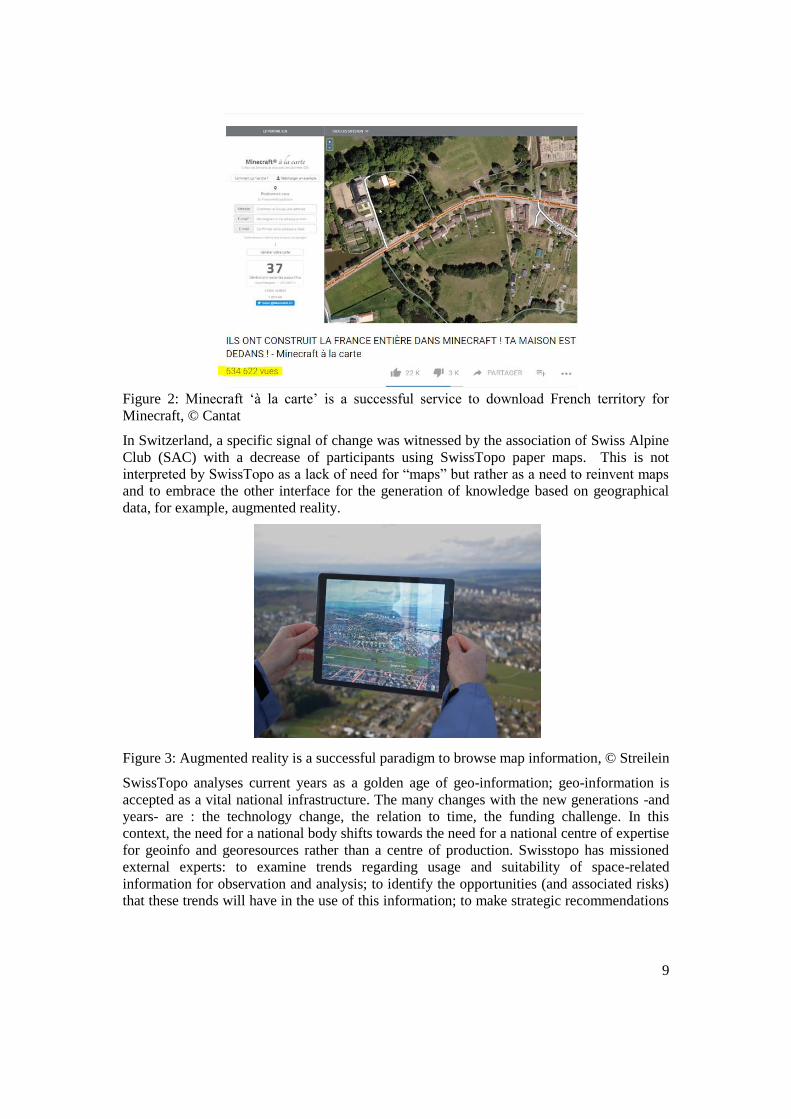
Minecraft data sets, https://minecraft.ign.fr/-, and organizes specific events for young people
-Escape game- and last has inaugurated more generally a new physical place, called
Georoom.
Page 11
9
Figure 2: Minecraft ‘à la carte’ is a successful service to download French territory for
Minecraft, © Cantat
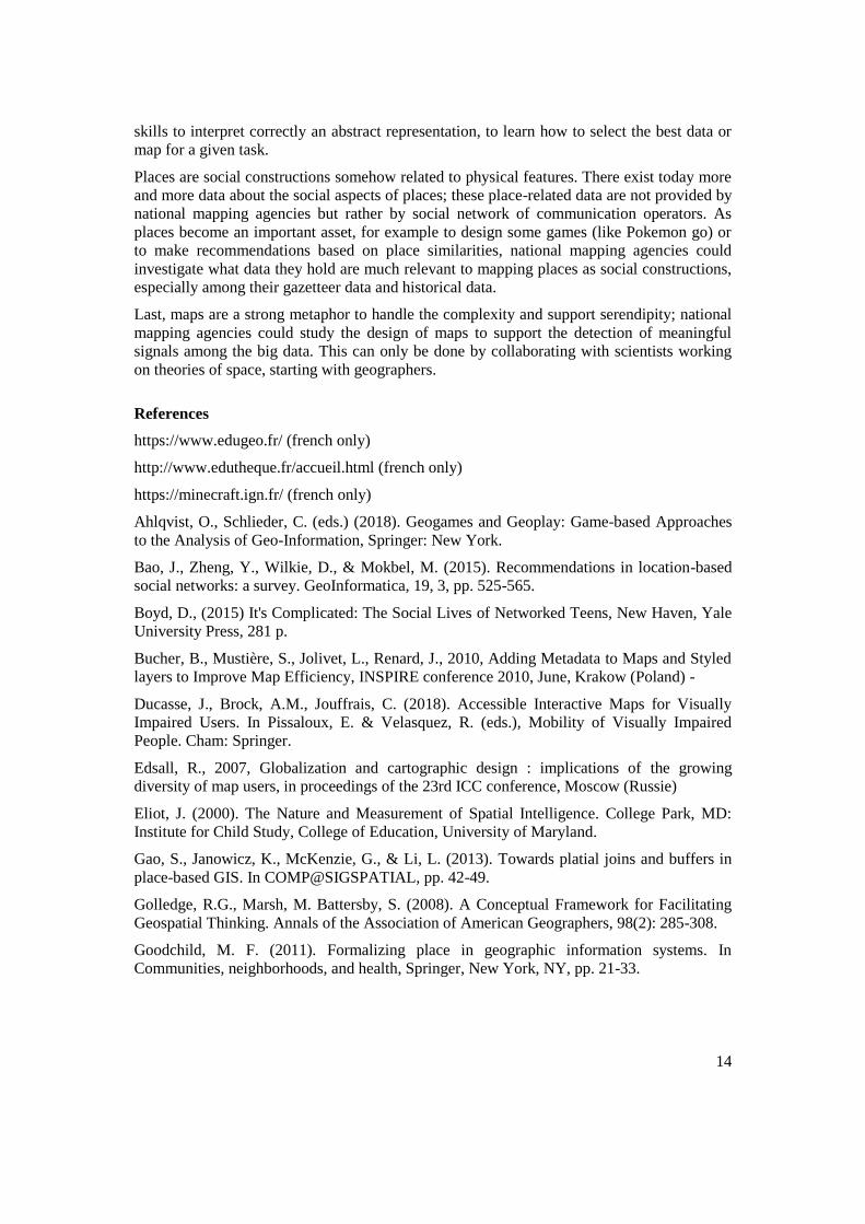
In Switzerland, a specific signal of change was witnessed by the association of Swiss Alpine
Club (SAC) with a decrease of participants using SwissTopo paper maps. This is not
interpreted by SwissTopo as a lack of need for “maps” but rather as a need to reinvent maps
and to embrace the other interface for the generation of knowledge based on geographical
data, for example, augmented reality.
Figure 3: Augmented reality is a successful paradigm to browse map information, © Streilein
SwissTopo analyses current years as a golden age of geo-information; geo-information is
accepted as a vital national infrastructure. The many changes with the new generations -and
years- are : the technology change, the relation to time, the funding challenge. In this
context, the need for a national body shifts towards the need for a national centre of expertise
for geoinfo and georesources rather than a centre of production. Swisstopo has missioned
external experts: to examine trends regarding usage and suitability of space-related
information for observation and analysis; to identify the opportunities (and associated risks)
that these trends will have in the use of this information; to make strategic recommendations
Page 12
10
regarding the impact of the above on the data, production methodologies, services and
resource capabilities on the organisation over the next 5-10 years.
The large amounts of digital data as well as the raise of machine learning are game changers
in surveying and map making. Next generations will more and more need ‘maps’ useful to
detect meaningful patterns in these data. Meaningfulness can only be estimated based on a
predefine knowledge and theory. Future maps could support the connection to these theories.
2 Perspectives brought from science
2.1 Christoph Schlieder: Place models beyond territoriality
Research on place-based GIS studies geodata services, which present and represent the
environment in forms that are close to the user's cognitive conceptualization of places. The
talk contrasted space-based with place-based information processing tasks and discussed
lessons learned from two application scenarios: geographic recommender systems for
tourists and educational location-based games. In both scenarios, the spatial
conceptualizations are epistemic in the sense that it matters not just, whether some place A is
part of some other place B, but also that the social actors believe this to be the case. Such
epistemic place models may help to get a better understanding of shared (or: non-territorial)
uses of place-based resources.
Results and applications of place research
While traditional GIS represent space mainly by reference to physical properties, research on
place-based or “palatial” GIS focuses on capturing the social construction of places. It
emphasizes, for instance, geo-referencing by toponyms over spatial reference systems
(Goodchild, 2011). Palatial GIS aims at supporting the qualitative methods of human
geography more than the type of quantitative analysis offered by current GIS technology
(Roche, 2015). The difference between the two perspectives is also one of data sources.
Researchers on palatial GIS often study data extracted from social media that may give more
weight to subjectivity and new clues for relevance. An example illustrating the contrast
between the spatial and palatial perspective is the buffering operation. While a spatial buffer
simply consists of a circular region around a reference point, a palatial buffer takes the
geographic conceptualization of the reference point and its surroundings into account to
determine, for instance, which cities are considered neighbours in texts published on web
sites from Santa Barbara, CA (Gao, Janowicz, McKenzie, Li, 2013).
The study of place has been approached by considering specific spatial activities, which
involve social interaction such as playing location-based games or recommending touristic
places. Research on location-based games shows that knowledge about the places where
players can play the game constitute a critical resource (Ahlqvist, Schlieder, 2018). Places of
game play are not abundant since they have to satisfy a number of constraints such as being
easy to reach by public transportation, permitting the access of players, and being
sufficiently spacious to accommodate players without disrupting the daily routines of non-
players. Part of the success of games such as Ingress or Pokémon GO is due to their effective
place design by crowdsourcing.
Research on recommender systems for touristic places finds that the popularity of places
varies considerably according to a power law (Schlieder, Matyas, 2009). A primary objective
of recommendation consists in providing information, which helps tourists to find places that
Page 13
11
although being less popular, are nevertheless of specific interest to them. Recommender
systems base their results on different methods for determining the similarity of spatial
choices (Bao et al., 2015). Data about spatial choices such as the personal preferences for
places are crucial for any recommendation system and constitute a valuable economic
resource.
Discussion on possible recommendations for NMA
In both application scenarios presented before, location-based games and tourist
recommender systems, information about places constitute a valuable resource.
As far as location-based games are concerned, it would be interesting to identify potential
places of game play from base data features. This does not necessarily mean to introduce a
new feature type “playable place”. However, it would definitively help game designers to
have information about whether or not an open space is accessible to the public. Obviously,
terrain models are important to location-based games as to other types of leisure activity. The
same holds for features, which help players to identify landmarks such as the height and the
colour of buildings.
Geographic recommender systems depend on data about individual spatial behaviour, which
is gathered mainly by the companies that offer mobile operating systems (Google, Apple) or
location-based services (e.g. Uber, Airbnb). It is difficult to see how NMA could become
providers of that kind of data. However, there are data of interest to recommender services,
which relate more closely to the expertise of NMA. An example are historical maps, another
example are gazetteers of colloquial place names.
Gamification and recommending may also be considered under a NMA user perspective.
Educational games, especially location-based ones that are played in the geographic
environment, can help to learn how to use maps. Likewise, recommended services could
guide non-expert users towards data matching their interest.
2.2 Marinos Kavouras: The new generation of spatial thinking citizens
What is common in tasks such as reading a map, finding your way in a shopping mall,
interpreting a diagram, and understanding the spatial distribution of a phenomenon or the
association of places and events? They are all tasks that rely on a mental skill called spatial
or geospatial thinking. Spatial thinking has lately been acknowledged as an important ability
both for sciences and everyday life. A 2006 report from the US National Research Council
"Learning to Think Spatially: GIS as a Support System in the K-12 Curriculum" underlined
that "without explicit attention to [spatial literacy], we cannot meet our responsibility for
equipping the next generation of students for life and work in the 21st century". Spatial
thinking is considered as a key ability for the STEM disciplines (Science, Technology,
Engineering, and Mathematics). Research results stress the rewarding effects of developing
geospatial skills in increasing the participation in STEM disciplines, lacking of which acts as
a barrier for students leading them to dropout. This presentation outlines the major aspects
and latest developments of spatial thinking in the digital era.
Results and applications of research on spatial thinking education
Inclusive education embraces the diversity of the world and recognizes that all children,
regardless of ability, deserve equal educational opportunities. It is also proving to be an
effective educational model which benefits all children. Spatial reasoning is well-suited to
the needs of inclusive education. It provides a good basis for open-ended problem-solving
Page 14
12
tasks and science inquiry activities. Thus, it can help maintain the interest of all students and
foster collaboration in a diverse class, with multiple benefits.
Spatial thinking is defined as the cognitive ability to visualize and interpret location,
position, distance, direction, relationships, movement, and change over space, in different
situations and at different scales (Sinton et al, 2013). It is essential in science. (Geo)spatial
thinking is related to, but wider in scope than spatial ability, the second being limited to the
table-top scale.
The competence of spatial thinking, usage and interpretation of maps or other spatial tools is
not self-evident for all. It is a dexterity which must be cultivated. Geospatial literacy can
vary according to age, background knowledge, education, cultural and ethnic background,
distinct living conditions and other factors. Special target groups may need appropriate
knowledge components to enhance their geospatial skills, which will help them overcome
susceptibility to poverty, social exclusion and dropout. Spatial skills can be improved
through training and the improvements in cognitive spatial ability are durable. Training can
bridge gender differences in geospatial literacy. It can also affect the choice of careers (e.g.
STEM disciplines), which has been linked to performance on spatial skills tests.
Project GEOTHNK-“Semantic Pathways for Building a Spatially-Thinking Society” has
aimed at developing an innovative, socially enabled learning platform for enhancing
geospatial thinking skills. The project addresses a variety of target groups (students, teachers,
science centre educators, adult learners), using an ICT-based approach and an open,
collaborative educational environment which allows for the interdisciplinary organization
and semantic linkage of knowledge. Users are supported in an inquiry-based learning
experience, in which geospatial concepts and ideas are taught in a way that emphasizes their
correlation and relevance. The project has been supported by the European Union through
the Lifelong Learning Programme (2013-2015).
Project VISTE (2016-2019), builds upon the experience of GEOTHNK, with the aim of
empowering the spatial thinking of primary and secondary school children with visual
impairment (VI). For students with disabilities, such as VI, spatial thinking is an imperative
skill for perceiving the world. The visually impaired face important challenges related to
orientation and mobility, with implications for their personal and professional life and for
their inclusion in society overall. ICT technologies and interactive maps have the potential to
provide a broad spectrum of the population with spatial knowledge, irrespective of age,
impairment, skill level and other factors. They can overcome the limitations of raised-line
paper maps with Braille text, which had traditionally been proposed for the visually
impaired.
VISTE project partners, representing different areas of expertise, are working together to
develop strategies, educational components and an ICT toolkit toward effective spatial
thinking of students with VI, facilitating inclusion. The project is co-funded by the European
Union through the Erasmus+ programme.
Discussion
The discussion on mapping places for digital natives should not be based on the assumption
that generations are discriminated as being digitally able or not. There are a variety of issues
and differentiations to consider, apart from age.
Page 15
13
Some issues of interest with regard to cartography and spatial thinking for digital natives,
could be the following:
• Digital natives need dynamic maps, whereas in the past, maps had traditionally been
static.
• Multimodal interfaces are the norm among digital natives. They are also highly
useful in inclusive education.
• With digital media, the God’s eye view traditionally used in cartography is being
replaced by the ego-cantered views of individuals communicating in space; the new
tools should be developed/ adjusted accordingly.
• Digital natives have a tendency to multitask; the design of application environments
may need to take this tendency into account.
• They tend to use space based on common sense rather than rigorous scientific
research – expert knowledge.
• Through gaming etc, they have been accustomed to cooperation – networking. This
may be of use in designing spatial applications which support co-operation.
• With the advent of crowd sourcing, what the majority think to be the case becomes
the dominant view: Così è (se vi pare) [It is so, (If you think so)].
• People, especially, children and teenagers, will do what it is “fun” to do. Gaming is
of particular interest in spatial thinking education.
• Following the trend, contests, recognition, “likes” may be considered in order to
enhance learners’ motivation.
• Personalization has been a growing trend in several aspects of life, including
mapping.
2.3 Marta Severo: Social media for mapping places: from VGI to the check-in
New technologies, and notably social media, have profoundly changed the relationship of
young people to maps. On the one hand, through applications such as Google Maps and
Waze, but also through recommendation platforms such as TripAdvisor or Foursquare, maps
become everyday tools that facilitate the orientation in the geographical space and the
identification of good addresses. On the other hand, Digital Natives are more conscious of
their location and of the link to places thanks to the success of the “check-in”, that is to say
the public declaration of the position on Facebook, Instagram or Twitter. New
communication platforms are proposing to young people new approaches to mapping. In this
digital era, social networks can be seen as ‘cool’ digital places. Social network relate to
physical geography in the sense that an important aspect of space is the affordances of social
network.
3 Wrap up and perspectives
As a summary, the raise of digital technologies in our societies leads to new challenges and
opportunities in the domain of mapping places for and with our society.
In education for instance, digital technologies are opportunities to design new pedagogic
material, to integrate game patterns to motivate the students -or the learner more generally-.
This opens important perspectives in inclusive education that is a challenge of our societies.
Video games like Minecraft are technologies that can be considered to design new pedagogic
materials. Digital technologies also present challenges for education: to teach the required
Page 16
14
skills to interpret correctly an abstract representation, to learn how to select the best data or
map for a given task.
Places are social constructions somehow related to physical features. There exist today more
and more data about the social aspects of places; these place-related data are not provided by
national mapping agencies but rather by social network of communication operators. As
places become an important asset, for example to design some games (like Pokemon go) or
to make recommendations based on place similarities, national mapping agencies could
investigate what data they hold are much relevant to mapping places as social constructions,
especially among their gazetteer data and historical data.
Last, maps are a strong metaphor to handle the complexity and support serendipity; national
mapping agencies could study the design of maps to support the detection of meaningful
signals among the big data. This can only be done by collaborating with scientists working
on theories of space, starting with geographers.
References
https://www.edugeo.fr/ (french only)
http://www.edutheque.fr/accueil.html (french only)
https://minecraft.ign.fr/ (french only)
Ahlqvist, O., Schlieder, C. (eds.) (2018). Geogames and Geoplay: Game-based Approaches
to the Analysis of Geo-Information, Springer: New York.
Bao, J., Zheng, Y., Wilkie, D., & Mokbel, M. (2015). Recommendations in location-based
social networks: a survey. GeoInformatica, 19, 3, pp. 525-565.
Boyd, D., (2015) It's Complicated: The Social Lives of Networked Teens, New Haven, Yale
University Press, 281 p.
Bucher, B., Mustière, S., Jolivet, L., Renard, J., 2010, Adding Metadata to Maps and Styled
layers to Improve Map Efficiency, INSPIRE conference 2010, June, Krakow (Poland) -
Ducasse, J., Brock, A.M., Jouffrais, C. (2018). Accessible Interactive Maps for Visually
Impaired Users. In Pissaloux, E. & Velasquez, R. (eds.), Mobility of Visually Impaired
People. Cham: Springer.
Edsall, R., 2007, Globalization and cartographic design : implications of the growing
diversity of map users, in proceedings of the 23rd ICC conference, Moscow (Russie)
Eliot, J. (2000). The Nature and Measurement of Spatial Intelligence. College Park, MD:
Institute for Child Study, College of Education, University of Maryland.
Gao, S., Janowicz, K., McKenzie, G., & Li, L. (2013). Towards platial joins and buffers in
place-based GIS. In COMP@SIGSPATIAL, pp. 42-49.
Golledge, R.G., Marsh, M. Battersby, S. (2008). A Conceptual Framework for Facilitating
Geospatial Thinking. Annals of the Association of American Geographers, 98(2): 285-308.
Goodchild, M. F. (2011). Formalizing place in geographic information systems. In
Communities, neighborhoods, and health, Springer, New York, NY, pp. 21-33.
Page 17
15
Kavouras, M., Kokla, M., Tomai, E., Darra, A., Pastra, K. (2016). GEOTHNK: A Semantic
Approach to Spatial Thinking. In Gartner, G., Jobst, M., Huang., H. (eds.), Progress in
Cartography: EuroCarto 2015. Berlin: Springer.
Kent, A.J. , 2008. Cartographic blandscapes and the new noise: Finding the good view in a
topographical mashup. The Bulletin of the Society of Cartographers. 42(1, 2): 29–37
Kent, A., J., 2009. Topographic Maps: Methodological Approaches for Analyzing
Cartographic Style, in Journal of Map & Geography Librairies, Vol 5, pp.131-156
National Research Council (2006). Learning to Think Spatially: GIS as a Support System in
the K-12 Curriculum. Washington, D.C.: The National Academies Press.
Robinson, A., Morrison, J., Muehrke, P., Kimmerling, A., Guptill, S., 1995, Elements of
Cartography, Wiley, New York
Roche, S. (2016). Geographic information science II: Less space, more places in smart cities.
Progress in Human Geography, 40(4), pp. 565-573.
Schlieder, C., Matyas (2009). Photographing a city: An analysis of place concepts based on
spatial choices. Spatial Cognition & Computation, 2009, 9, 3, pp. 212-228.
Sinton, D., Bendarz, S. Gershmehl, P., Kolvoord R., Uttal, D. (2013). The People’s Guide to
Spatial Thinking. Washington, DC: National Council for Geographic Education.