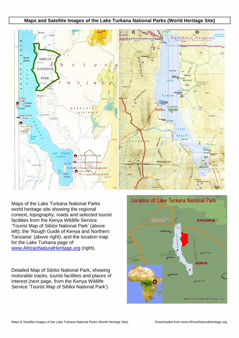
Maps & Satellite Images of the Lake Turkana National Parks (World Heritage Site) Downloaded from www.AfricanNaturalHeritage.org Maps and Satellite Images of the Lake Turkana National Parks (World Heritage Site) Maps of the Lake Turkana National Parks world heritage site showing the regional context, topography, roads and selected tourist facilities from the Kenya Wildlife Service ‘Tourist Map of Sibiloi National Park’ (above left); the ‘Rough Guide of Kenya and Northern Tanzania’ (above right); and the location map for the Lake Turkana page of www.AfricanNaturalHeritage.org (right). Detailed Map of Sibiloi National Park, showing motorable tracks, tourist facilities and places of interest (next page, from the Kenya Wildlife Service ‘Tourist Map of Sibiloi National Park’)
Transcript
Maps & Satellite Images of the Lake Turkana National Parks (World Heritage Site) Downloaded from www.AfricanNaturalHeritage.org
Maps and Satellite Images of the Lake Turkana National Parks (World Heritage Site)
Maps of the Lake Turkana National Parks world heritage site showing the regional context, topography, roads and selected tourist facilities from the Kenya Wildlife Service ‘Tourist Map of Sibiloi National Park’ (above left); the ‘Rough Guide of Kenya and Northern Tanzania’ (above right); and the location map for the Lake Turkana page of www.AfricanNaturalHeritage.org (right). Detailed Map of Sibiloi National Park, showing motorable tracks, tourist facilities and places of interest (next page, from the Kenya Wildlife Service ‘Tourist Map of Sibiloi National Park’)
Maps & Satellite Images of the Lake Turkana National Parks (World Heritage Site) Downloaded from www.AfricanNaturalHeritage.org
Maps & Satellite Images of the Lake Turkana National Parks (World Heritage Site) Downloaded from www.AfricanNaturalHeritage.org
Maps of the Lake Turkana region, showing the location of the principal threats to the integrity of the world heritage site, notably the oil exploration concessions awarded to Tullow Oil (top left); the ‘cascade’ of hydropower developments planned for the Omo River in Ethiopia (top right), and the extent of proposed irrigated agriculture in the lower Omo Valley (bottom left). If irrigation projects are implemented to their full extent as planned, the depth of Lake Turkana could be reduced by 40m, leaving two much smaller, highly saline lakes almost devoid of life (bottom right; see SWARA magazine article by Sean Avery, available at www.AfricanNaturalHeritage.org, for further information)
Maps & Satellite Images of the Lake Turkana National Parks (World Heritage Site) Downloaded from www.AfricanNaturalHeritage.org
Google Earth satellite image of the southern end of Lake Turkana, showing the location of South Island National Park
Satellite images of the Lake Turkana Basin (left) and detail for South Island National Park (right, Google Earth)
The central portion of Lake Turkana showing the location and context of Sibiloi and Central Island National Parks
Maps & Satellite Images of the Lake Turkana National Parks (World Heritage Site) Downloaded from www.AfricanNaturalHeritage.org
Google Earth satellite image of the northern end of South Island National Park showing its volcanic features
Google Earth satellite image of Central Island National Park showing its volcanic features, including the crater lakes that
serve as breeding and nursery areas for part of Lake Turkana’s substantial population of Nile crocodiles.
Detail of one of the crater lakes on central island, part of the Lake Turkana National Parks world heritage site
Maps & Satellite Images of the Lake Turkana National Parks (World Heritage Site) Downloaded from www.AfricanNaturalHeritage.org
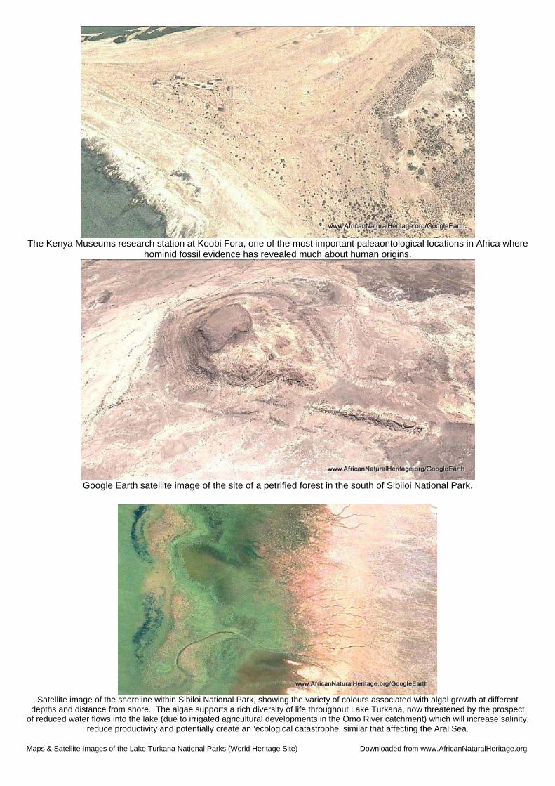
The Kenya Museums research station at Koobi Fora, one of the most important paleaontological locations in Africa where
hominid fossil evidence has revealed much about human origins.
Google Earth satellite image of the site of a petrified forest in the south of Sibiloi National Park.
Satellite image of the shoreline within Sibiloi National Park, showing the variety of colours associated with algal growth at different
depths and distance from shore. The algae supports a rich diversity of life throughout Lake Turkana, now threatened by the prospect of reduced water flows into the lake (due to irrigated agricultural developments in the Omo River catchment) which will increase salinity,
reduce productivity and potentially create an ‘ecological catastrophe’ similar that affecting the Aral Sea.
Maps & Satellite Images of the Lake Turkana National Parks (World Heritage Site) Downloaded from www.AfricanNaturalHeritage.org
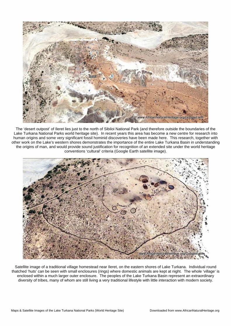
The ‘desert outpost’ of Ileret lies just to the north of Sibiloi National Park (and therefore outside the boundaries of the Lake Turkana National Parks world heritage site). In recent years this area has become a new centre for research into human origins and some very significant fossil hominid discoveries have been made here. This research, together with
other work on the Lake’s western shores demonstrates the importance of the entire Lake Turkana Basin in understanding the origins of man, and would provide sound justification for recognition of an extended site under the world heritage
Satellite image of a traditional village homestead near Ileret, on the eastern shores of Lake Turkana. Individual round thatched ‘huts’ can be seen with small enclosures (rings) where domestic animals are kept at night. The whole ‘village’ is
enclosed within a much larger outer enclosure. The peoples of the Lake Turkana Basin represent an extraordinary diversity of tribes, many of whom are still living a very traditional lifestyle with little interaction with modern society.
Maps & Satellite Images of the Lake Turkana National Parks (World Heritage Site) Downloaded from www.AfricanNaturalHeritage.org
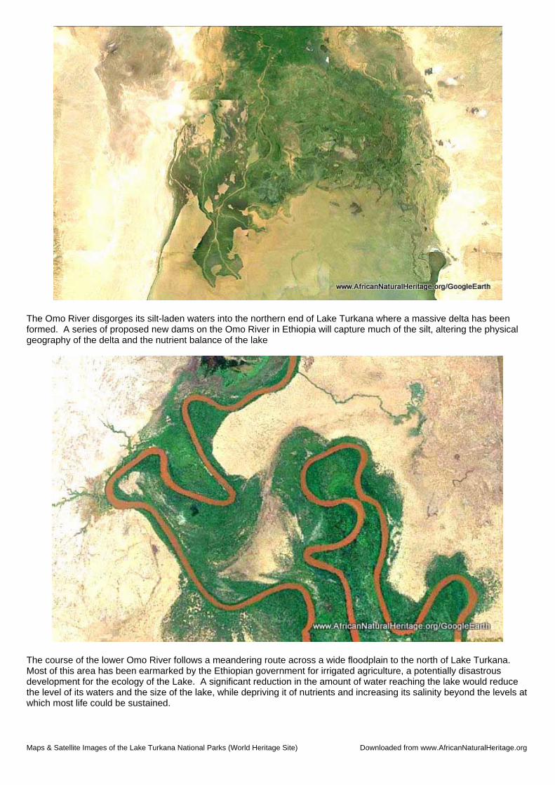
The Omo River disgorges its silt-laden waters into the northern end of Lake Turkana where a massive delta has been formed. A series of proposed new dams on the Omo River in Ethiopia will capture much of the silt, altering the physical geography of the delta and the nutrient balance of the lake
The course of the lower Omo River follows a meandering route across a wide floodplain to the north of Lake Turkana. Most of this area has been earmarked by the Ethiopian government for irrigated agriculture, a potentially disastrous development for the ecology of the Lake. A significant reduction in the amount of water reaching the lake would reduce the level of its waters and the size of the lake, while depriving it of nutrients and increasing its salinity beyond the levels at which most life could be sustained.
Maps & Satellite Images of the Lake Turkana National Parks (World Heritage Site) Downloaded from www.AfricanNaturalHeritage.org
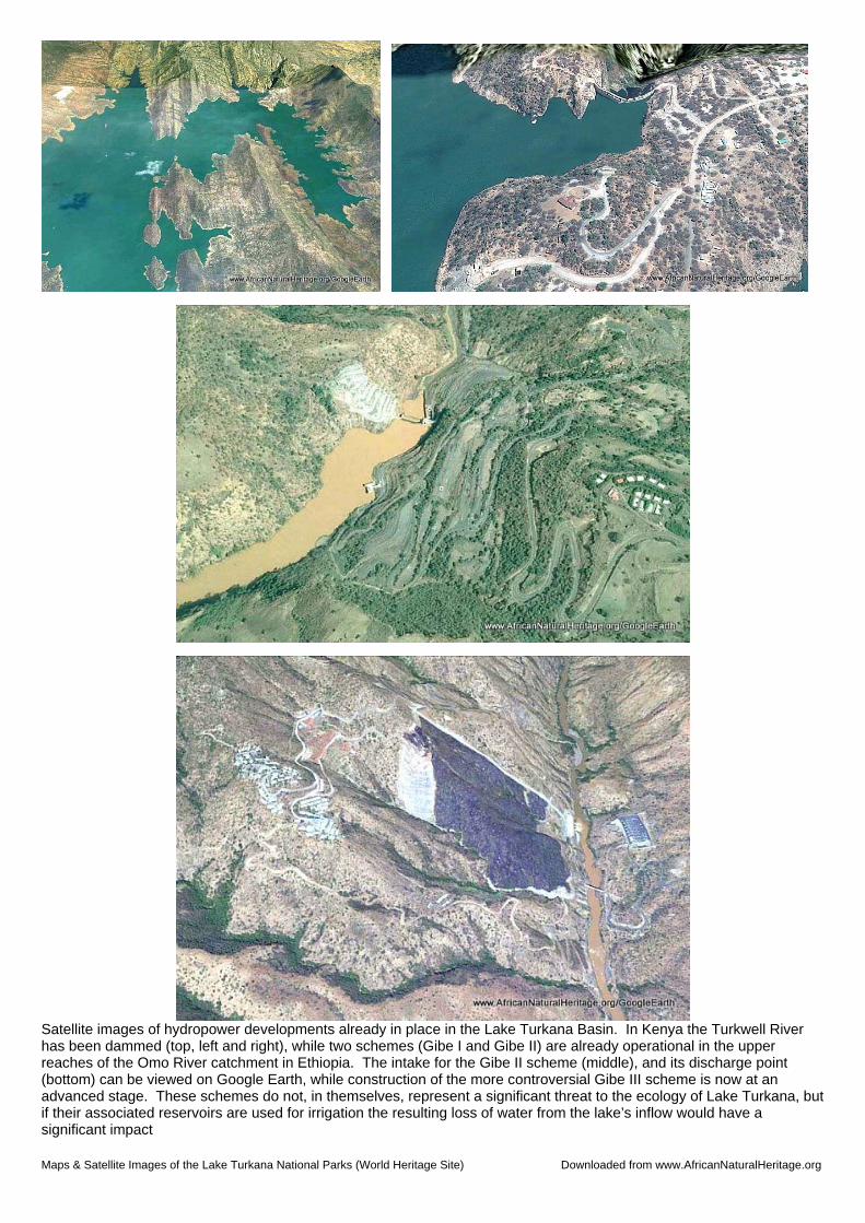
Satellite images of hydropower developments already in place in the Lake Turkana Basin. In Kenya the Turkwell River has been dammed (top, left and right), while two schemes (Gibe I and Gibe II) are already operational in the upper reaches of the Omo River catchment in Ethiopia. The intake for the Gibe II scheme (middle), and its discharge point (bottom) can be viewed on Google Earth, while construction of the more controversial Gibe III scheme is now at an advanced stage. These schemes do not, in themselves, represent a significant threat to the ecology of Lake Turkana, but if their associated reservoirs are used for irrigation the resulting loss of water from the lake’s inflow would have a significant impact
Maps & Satellite Images of the Lake Turkana National Parks (World Heritage Site) Downloaded from www.AfricanNaturalHeritage.org
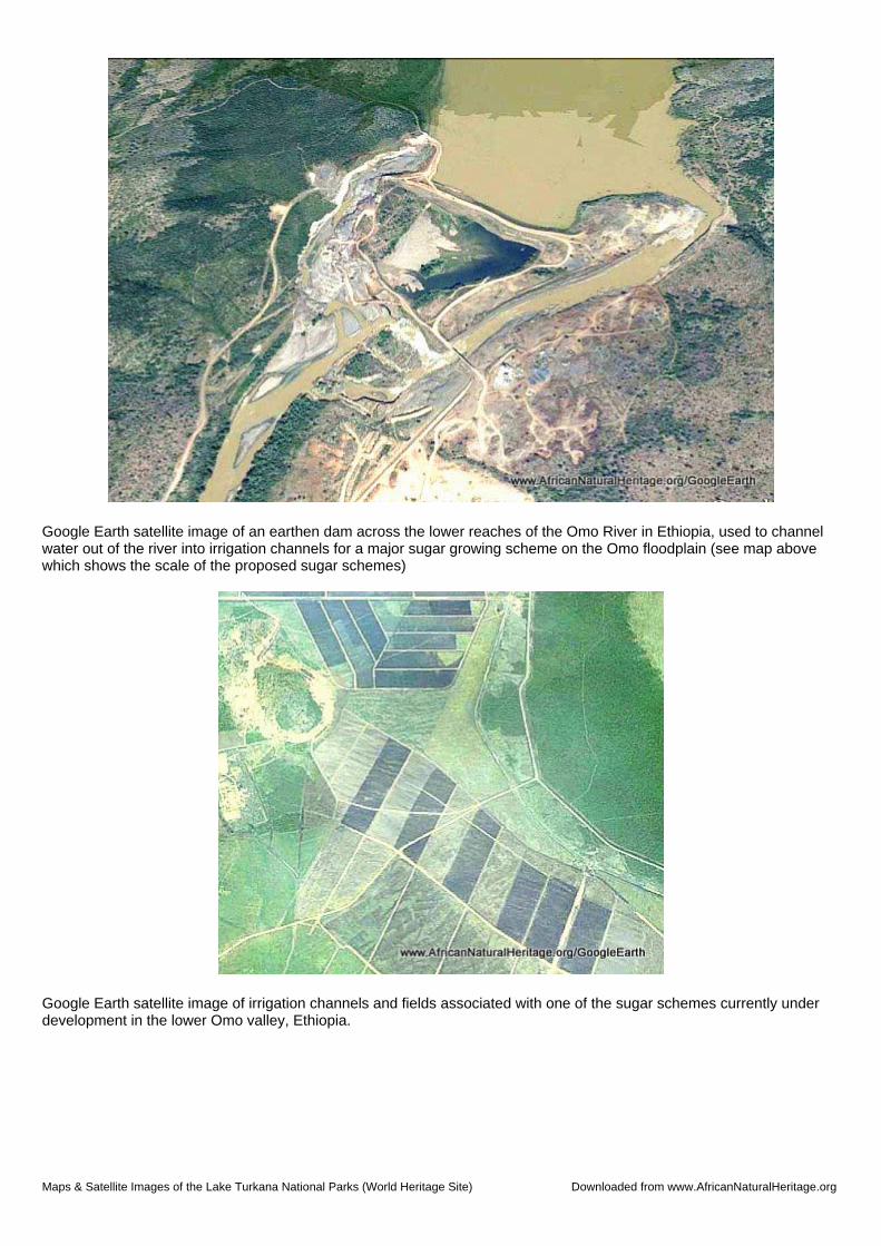
Google Earth satellite image of an earthen dam across the lower reaches of the Omo River in Ethiopia, used to channel water out of the river into irrigation channels for a major sugar growing scheme on the Omo floodplain (see map above which shows the scale of the proposed sugar schemes)
Google Earth satellite image of irrigation channels and fields associated with one of the sugar schemes currently under development in the lower Omo valley, Ethiopia.