+ All Categories
Home > Documents > Margarita (MWD) Communication Site

Margarita (MWD) Communication Site

Date post: 18-Mar-2022
Category:
Upload: others
View: 1 times
Download: 0 times
Share this document with a friend
6
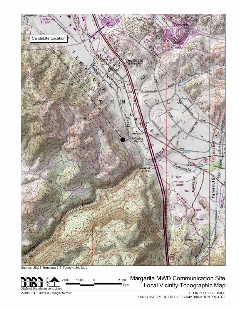
County of Riverside Public Safety Enterprise Communication Project Appendix A: Candidate Site Descriptions Margarita (MWD) Communication Site Michael Brandman Associates 1 H:\Client\2749\27490003\ADEIR_4-30-08\Appendices\App A Candidate Site Descriptions\Margarita (MWD).doc Margarita (MWD) Communication Site Overview The site is located on an east-facing slope overlooking Murrieta Creek and the Temecula Valley, and is located approximately 0.25 mile west of the Interstate 15 and State Route 79 interchange. Old Town Temecula lies approximately one mile north of the site. The proposed project would place a tower and equipment shelter at the site. Table 1: Margarita (MWD) Communication Site Surrounding Land Uses The site is located within the right-of-way of the Metropolitan Water District (MWD) underground pipeline that supplies water to the greater San Diego metropolitan area. The site is located on an east- facing slope overlooking the Temecula Valley. Upslope from the site are numerous estate-style homes on large lots. Downslope from the site, Murrieta Creek parallels Interstate 15. The State Route 79 interchange is situated within 0.25 mile of the project site. Between the site and the freeway, Front Street serves as a frontage road. The road contains numerous commercial facilities, as well as a concrete plant. North and south of the site, the east-facing slope continues, comprised largely of open space. Topography and Vegetation The site is located on an east-facing slope overlooking Murrieta Creek and the Temecula Valley. The MWD right-of-way upon which the site is located is highly disturbed, and essentially forms an access road that runs up the side of the slope. The vegetation outside of this disturbed area is comprised of a coastal sage scrub plant community, including California buckwheat, white sage, deerweed, California sagebrush, and sticky monkey flower. A gully immediately south of the site contains sparse occurrences of arroyo willow, mule fat, and tree tobacco. An oak woodland occurs upslope of the site, and many coast live oak trees are found to the southwest. Land Ownership and Applicable Habitat/Land Management Plan The site is on land owned and operated by the MWD and is subject to the WRMSHCP. The site is located within an Existing Core Area in the “Southwest” Area Plan, SU1-Murrieta Creek Sub-unit, and falls within Criteria Cell 7355. Additionally, the site is located within a fee area under the Latitude 1 Longitude 1 Elev 2 Address T/R/S 3 APN 4 USGS Quadrangle 33°28’46.7” 117°08’46.2” 1,070 No address assigned 8S, 3W, Sec. 13 (Projected) 922-210- 011 Temecula 1 – All coordinates utilize NAD83 datum 2 – All elevations in feet above mean sea level 3 – Township/Range/Section (San Bernardino Base Meridian) 4 – All Assessors Parcel Numbers are located in Riverside County, unless noted: OC = Orange County; SD = San Diego County; SB = San Bernardino County
Transcript

County of Riverside Public Safety Enterprise Communication ProjectAppendix A: Candidate Site Descriptions Margarita (MWD) Communication Site

Michael Brandman Associates 1H:\Client\2749\27490003\ADEIR_4-30-08\Appendices\App A Candidate Site Descriptions\Margarita (MWD).doc

Margarita (MWD) Communication Site

Overview

The site is located on an east-facing slope overlooking Murrieta Creek and the Temecula Valley, andis located approximately 0.25 mile west of the Interstate 15 and State Route 79 interchange. OldTown Temecula lies approximately one mile north of the site. The proposed project would place atower and equipment shelter at the site.

Table 1: Margarita (MWD) Communication Site

Surrounding Land Uses

The site is located within the right-of-way of the Metropolitan Water District (MWD) undergroundpipeline that supplies water to the greater San Diego metropolitan area. The site is located on an east-facing slope overlooking the Temecula Valley. Upslope from the site are numerous estate-stylehomes on large lots. Downslope from the site, Murrieta Creek parallels Interstate 15. The State Route79 interchange is situated within 0.25 mile of the project site. Between the site and the freeway, FrontStreet serves as a frontage road. The road contains numerous commercial facilities, as well as aconcrete plant. North and south of the site, the east-facing slope continues, comprised largely of openspace.

Topography and Vegetation

The site is located on an east-facing slope overlooking Murrieta Creek and the Temecula Valley. TheMWD right-of-way upon which the site is located is highly disturbed, and essentially forms an accessroad that runs up the side of the slope. The vegetation outside of this disturbed area is comprised of acoastal sage scrub plant community, including California buckwheat, white sage, deerweed,California sagebrush, and sticky monkey flower. A gully immediately south of the site containssparse occurrences of arroyo willow, mule fat, and tree tobacco. An oak woodland occurs upslope ofthe site, and many coast live oak trees are found to the southwest.

Land Ownership and Applicable Habitat/Land Management Plan

The site is on land owned and operated by the MWD and is subject to the WRMSHCP. The site islocated within an Existing Core Area in the “Southwest” Area Plan, SU1-Murrieta Creek Sub-unit,and falls within Criteria Cell 7355. Additionally, the site is located within a fee area under the

Latitude1 Longitude1 Elev2 Address T/R/S3 APN4 USGSQuadrangle

33°28’46.7” 117°08’46.2” 1,070 No address assigned 8S, 3W,Sec. 13

(Projected)

922-210-011

Temecula

1 – All coordinates utilize NAD83 datum2 – All elevations in feet above mean sea level3 – Township/Range/Section (San Bernardino Base Meridian)

4 – All Assessors Parcel Numbers are located inRiverside County, unless noted: OC = Orange County;SD = San Diego County; SB = San Bernardino County

County of Riverside Public Safety Enterprise Communication ProjectAppendix A: Candidate Site Descriptions Margarita (MWD) Communication Site

Michael Brandman Associates 2H:\Client\2749\27490003\ADEIR_4-30-08\Appendices\App A Candidate Site Descriptions\Margarita (MWD).doc

Western Riverside County SKRHCP and within Critical Habitat for coastal California gnatcatcher asdesignated by the USFWS.

Road Access

The MWD maintains an access road along their right-of-way, and this road can be used to access thesite.

Commercial Power Access

Commercial power is available from a pole line that runs approximately south of the site.

27490003 • 04/2008 | margarita.mxd

Margarita MWD Communication SiteLocal Vicinity Topographic MapNO

RTH

Michael Brandman Associates

Source: USGS Temecula 7.5' Topographic Map.

COUNTY OF RIVERSIDEPUBLIC SAFETY ENTERPRISE COMMUNICATION PROJECT

!!

2,000 0 2,0001,000Feet

Candidate Location

27490003 • 04/2008 | margarita_aerial.mxd

Margarita MWD Communication SiteLocal Vicinity Aerial MapNO

RTH

Michael Brandman Associates

Source: Riverside County NAIP, 2005.

COUNTY OF RIVERSIDEPUBLIC SAFETY ENTERPRISE COMMUNICATION PROJECT

500 0 500250Feet

LegendCandidate Location

Photograph 4: Overview of Margarita candidate location, facing north. Photograph 3: Overview of Margarita candidate location, facing east.

Photograph 2: View toward Margarita candidate location, facing south.

Photograph 1: Overview of Margarita candidate location, facing west.

Source: Michael Brandman Associates, 2008.

Margarita (MWD) Candidate Photographs 1 to 4 PSEC Project

Michael Brandman Associates 274900030 • 04/2008 | Margarita_Photo1.doc

Photograph 8: View from Margarita candidate location, facing northwest.

Photograph 7: View from Margarita candidate location, facing east.

Photograph 6: View from Margarita candidate location, facing southwest.

Photograph 5: View from Margarita candidate location, facing north.

Source: Michael Brandman Associates, 2008.

Margarita (MWD) Candidate Photographs 5 to 8 PSEC Project

Michael Brandman Associates 274900030 • 04/2008 | Margarita_Photo2.doc


Recommended