61
Marine Accident Analysis of Collisions and Groundings: How to learn from past incidents to avoid them in the future Webinar: International Union of Marine Insurance 10 April 2018
Marine Accident Analysis of Collisions and Groundings:
How to learn from past incidents to avoid them in the future
Webinar: International Union of Marine Insurance
10 April 2018

Marine Accident Analysis of Collisions and Groundings:
How to learn from past incidents to avoid them in the future
By Captain Paul Whyte MBE AFNI, Associate Master Mariner

Discussion Topics
• Situational Awareness
• Surveying the 3-D waterspace
• International Regulations for Preventing Collisions at Sea, 1972
• How Electronic Evidence Works
• Casualty Investigation and Accident Analysis
• Case Studies
• Conclusions.

Situational Awareness

“Navigation is not so much knowing where you are, but
knowing where you should not be”
“Collisions are usually avoided by awareness, anticipation,
application and action”
Situational Awareness: The Mystery

Surveying the 3-D waterspace

The Basics of Surveying

10m20m
50m
10m20m
50m
100m100m
The Basics of Surveying

• English Channel Chart
• Area K, NE lane Dover Straits TSS
• Today we consider quality
instead of the age of the survey
Paper Charts: Source Data Diagram

Electronic Charts: Category of Zones of Confidence

c
2-D Under Keel Clearance

c
2-D Under Keel Clearancec
Golden Gate
San Francisco Bay

c
2-D Under Keel Clearancec
Charleston
South Carolina
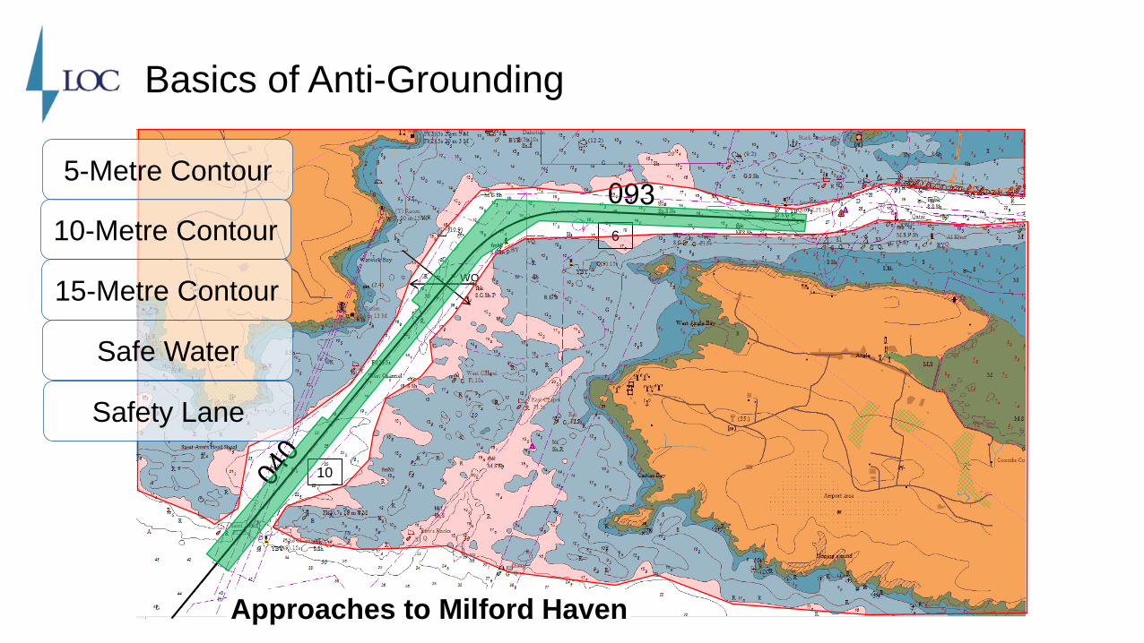
Basics of Anti-Grounding
10
6
WO
5-Metre Contour
10-Metre Contour
15-Metre Contour
Safe Water
Approaches to Milford Haven
Safety Lane

International Regulations to Prevent Collisions at Sea, 1972
(COLREGS)
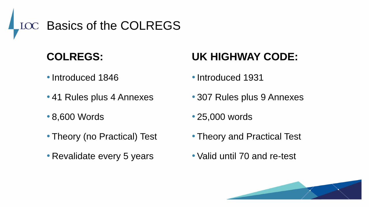
Basics of the COLREGS
COLREGS:
• Introduced 1846
• 41 Rules plus 4 Annexes
• 8,600 Words
• Theory (no Practical) Test
• Revalidate every 5 years
UK HIGHWAY CODE:
• Introduced 1931
• 307 Rules plus 9 Annexes
• 25,000 words
• Theory and Practical Test
• Valid until 70 and re-test

Basics of the COLREGS
•Awareness: maintain a proper lookout (R5)
•Anticipation: safe speed (R6) gives space and time to assess
•Application: know COLREGS and particularly risk of collision (R7)
•Action: take positive and early action to avoid a collision (R8).

When does a risk of collision exist? Zones of Interest
• Height of eye and radar range
• Vessel size
• Vessel speed and manoeuvrability
• Visibility
• Location
• Under keel clearance.

When does a risk of collision exist? Zones of Interest
• Height of eye and radar range
• Vessel size
• Vessel speed and manoeuvrability
• Visibility
• Location
• Under keel clearance.


Electronic Evidence

How Electronic Evidence Works: Modern Bridge

•Automatic Identification System (AIS)
•Electronic Chart Display and Information System (ECDIS)
•Voyage Data Recorder (VDR)
•Audio, Video and Still Images.
How it works: Sources of Electronic Evidence

How it works: Automatic Identification System (AIS)
Ship-to-Ship AIS
Ship-to-Shore AIS
Satellite AIS

• Vessels over 300 GT (Type A)
• Ship-to-ship situational awareness and manage controlled water space
• Public broadcast VHF transponder device and available open source
• Transmission frequency:
• Static: Every 6 minutes - Vessel details
• Dynamic: Dependant on speed and course - Time, position, course and speed
• Voyage Related: Every 6 minutes - Vessel draft, POB, haz cargo and where bound.
How it works: Automatic Identification System (AIS)

How it works: Automatic Identification System (AIS)
AIS Type A Reporting intervals of Dynamic Information
Manoeuvring Status Interval
Ships at anchor or moored and not faster than 3 knots 3 minutes
Ships at anchor or moored and faster than 3 knots 10 seconds
Ship 0-14 knots 10 seconds
Ship 0-14 knots and changing course 3⅓ seconds
Ship 14-23 knots 6 seconds
Ship 14-23 knots and changing course 2 seconds
Ship >23 knots 2 seconds
Ship >23 knots changing course 2 seconds

April
2018
How it works: ECDIS Roll-out and Principle Features

April
2018
• Electronic chart displaying ‘real-time’ position, course and speed
• Undertakes complex functions to improve ‘situational awareness’:
• Appraisal, planning, execution and monitoring
• Monitoring the safe conduct of the vessel.
• Time-saving route planning within pre-defined ‘safety corridor’
• Can ‘replay’ navigation over previous 12 hours
• Records entire voyage 4-hourly time marks.
How it works: ECDIS Roll-out and Principle Features

How it works: ECDIS [PlayStation Generation Y]
Dover Strait – West
Actually, a raster image that
looks like a paper chart
Life before ECDIS… the Paper Chart

How it works: ECDIS [PlayStation Generation Y]

How it works: Voyage Data Recorder (VDR)

How it works: Voyage Data Recorder (VDR)
• Passenger ships and vessels <3,000 GT
• VDR is a collection and storage device
• Continuous-loop recording (min 12 hours and 30 days from 01 Jul 2014)
• Records the command and control data of the vessel
• Long-term and float/fixed data storage.

How it works: VDR Replay Software

Casualty Investigation and Accident Analysis

Investigating Failures in Situational Awareness
•Groundings and collisions: failure of ‘situational awareness’
•Causation: forensic analysis of electronic evidence
•Validate: compare ‘contemporaneous’ evidence

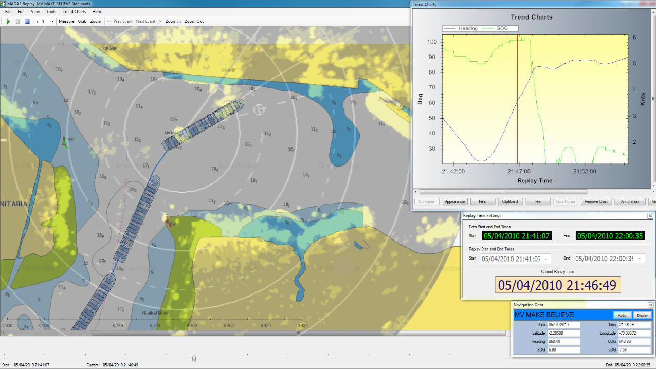
2-D MADAS (Marine Accident Data Analysis Suite)
• Developed by Avenca Ltd for UK MAIB and US NTSB.
• The software can:
• Display multiple tracks
• Extract and use AIS and/or VDR data
• Use audio tracks
• Display charts and overlays
• Display various media including radar overlay
• Display ship shapes.
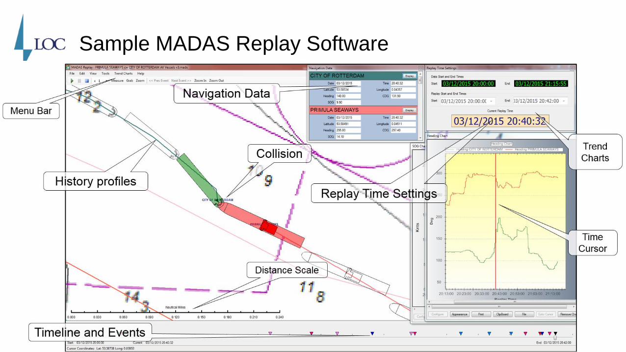
Sample MADAS Replay Software

MADAS Replay Software

3-D REMBRANDT (Real-time Manoeuvring, Berthing and Training)
• Developed by BMT and used by many shipowners, pilots and port authorities
• The software can model:
• Recreate environmental conditions
• Use raster and vector ENC charts to give bathymetric representation
• Visual topography with additional library or customer specified objects
• Large vessel database or tailored hull designs and propulsion configurations
• Imports same electronic data as MADAS.

REMBRANDT – Collision analysis
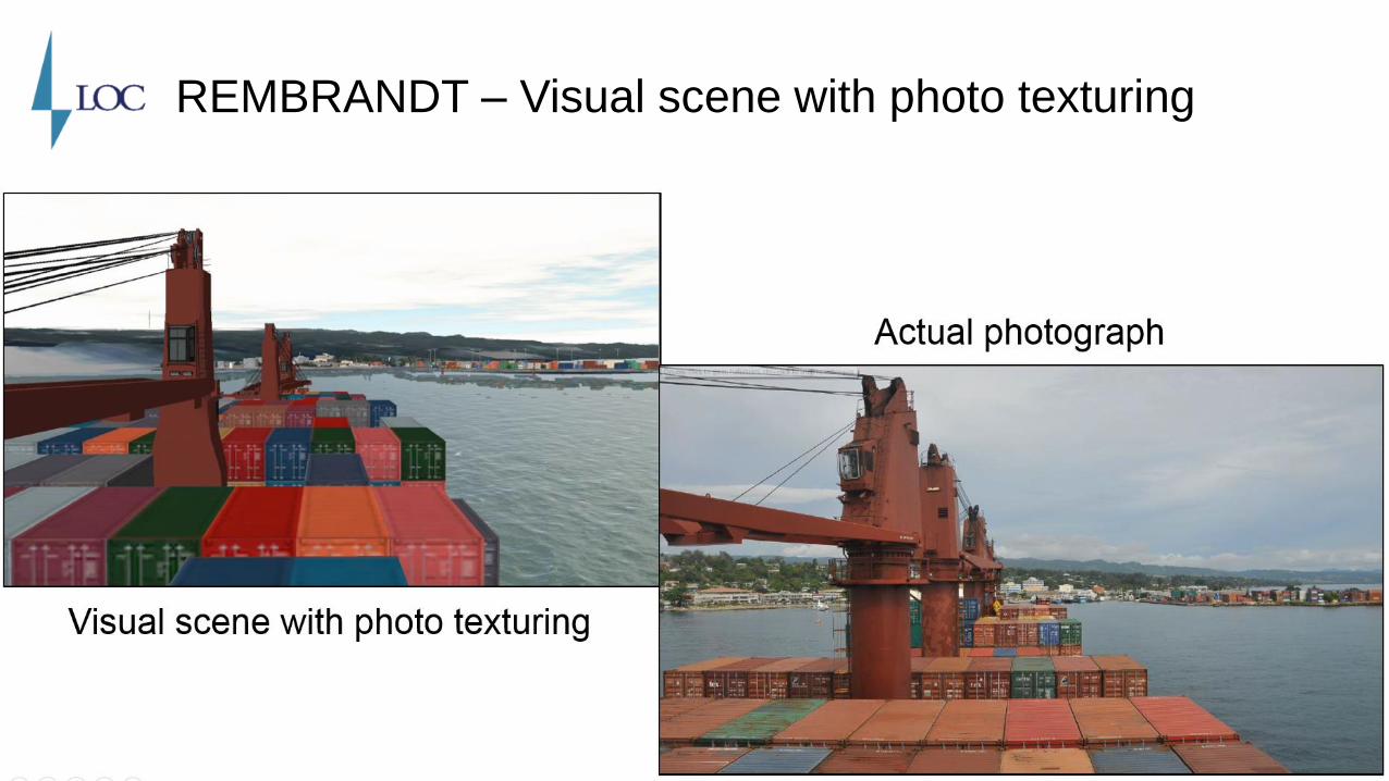
REMBRANDT – Visual scene with photo texturing

[Traditional] Casualty Investigation and Litigation
• Attend casualty, interview crew and take statements
• Collect contemporaneous [and digital] evidence
• Determine ‘angle of blow’ in collisions
• Determine ‘type and location of damage’ in groundings
• Disclose documentation [including digital evidence]
• Engage experts if no agreement
• Proceed to trial.
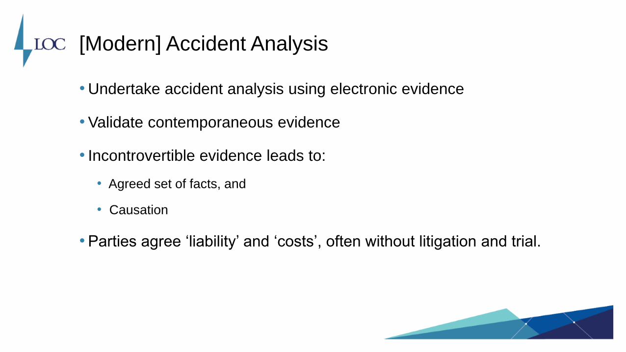
[Modern] Accident Analysis
• Undertake accident analysis using electronic evidence
• Validate contemporaneous evidence
• Incontrovertible evidence leads to:
• Agreed set of facts, and
• Causation
• Parties agree ‘liability’ and ‘costs’, often without litigation and trial.

Case Studies

Case 1: MV MAKE BELIEVE Allision with the Quayside
• 5th April 2010, Never Never Land
• Full VDR with radar overlay and audio
• Daylight in favourable conditions
• MV MAKE BELIEVE passes through narrow channel to approach berth
• No tugs in attendance.
(Screenshots i.e. not video)

MV MAKE BELIEVE Allision with the Quayside

MV MAKE BELIEVE Allision with the Quayside

MV MAKE BELIEVE Allision with the Quayside

MV MAKE BELIEVE Allision with the Quayside
MV MAKE BELIEVE Allision with the Quayside

Case 2: PRIMULA SEAWAYS c/w CITY OF ROTTERDAM
• Date 3rd December 2015, Humber Estuary, Hull, England
• Open-Source Terrestrial AIS, no VDR
• Dawn, poor visibility, and very high wind and sea
• CITY OF ROTTERDAM pilot embarked outbound
• PRIMULA SEAWAYS pilot exemption inbound.


Case 3: COLONEL MUSTARD c/w PROFESSOR PLUM
• April Fool’s Day 2016, Canal Interaction
• Full VDR both vessels
• Daylight good visibility and benign conditions
• PROFESSOR PLUM 5x the displacement of COLONEL MUSTARD
• PROFESSOR PLUM allowed overtake of COLONEL MUSTARD.


Case 4: BEEF WELLINGTON Fixed Object Damage
• 5th February 2017, South America
• Full VDR and shore-side CCTV
• Full darkness in calm conditions
• Berthing against strong river current
• No tugs in attendance.


Conclusions

Conclusions
•Specialist tools are needed to decipher electronic evidence
•Forensic analysis provides incontrovertible evidence
•Tools of the trade are 2-D analysis and 3-D visualisation
•The facts and causation can be quickly agreed
•Parties can quickly agree ‘liability’ and settle ‘costs’.

Marine Accident Analysis of Collisions and Groundings:
How to learn from past incidents to avoid them in the future
Webinar: International Union of Marine Insurance
10 April 2018

ONE PARTNER.
WORLDWIDE SUPPORT.


