Marine Fishery Development and User Rights Management in Jimo (China) Meng Su Ocean University of China, China Abstract In 2017, Jimo was established as a district in eastern Qingdao, a city located in the southeast of the Shandong Peninsula. In 2016, the city was ranked 9 th among the top 100 counties in China. The eastern part of the city borders the Yellow Sea, encompassing 2 517 km 2 of sea and 183 km of coastal line. The area is made up of seven natural bays, 28 islands of varying size, and 15 fishing port docks. Jimo benefits from abundant marine fisheries resources from its coast. The fisheries in this area have been operating since antiquity and today are mainly concentrated in the area of the Yellow Sea and Bohai. The economic output of the farming, forestry, animal husbandry and fisheries industries of Jimo was valued at RMB 11.5 billion in 2016, with fisheries accounting for a 33.5 percent of the total, or approximately RMB 3.85 billion. This case study explores the development and management of Jimo's marine fishery. First, it presents the current situation of marine fishery production and the mode of cooperation of the fishing village. It provides an overview of the formation and development of fishery management administration and measures in Jimo. Second, this study discusses the effects of the fishery management measures on fishery production and resources. Finally, it explores the challenges and shortcomings of Jimo’s current fishery management system and considers future approaches to fishery management based on user rights to achieve the restoration of the fishery. 1. INTRODUCTION At the end of 2017, Jimo became a district in eastern Qingdao, which is located in the southeast of the Shandong Peninsula in China (Figure 1). Prior to 2017, Jimo was a county-level city of Quingdao, which ranked 9 th among the top 100 counties in mainland China. The eastern part of the city borders the Yellow Sea, encompassing 2 517 km 2 of the sea and 183 km of coast. There are ten natural bays in the area, including Dingzi Bay, Aoshan Bay, and Kaolao Bay. In addition, the territory holds 28 large and small islands, with a total area of 5.04 km 2 , accounting for 34.8 percent of the total number of islands in Qingdao, and 1.8 percent of the total area. There are also 15 fishing ports including Lady island, which is a first-class fishing port and a second class opening port, with an area of 83.33 km 2 in an intertidal zone, and 15.33 km 2 in a rocky reef area [1] . In 2012, Jimo’s Aoshan Bay Street and Spring Street became the core sites for Qingdao’s Blue Silicon Valley, which is part of the Chinese marine economic development policy. Many projects were introduced including the construction of a National Deep-Sea Base, the Shandong University (Qingdao Campus), the Qingdao National Laboratory for Marine Science and Technology, and other projects. The 4.7 km Dingziwan Cross-Sea Bridge, which spans across the Dingzi Bay and connects the cities of Haiyang and Jimo, was recently completed as well. The coast in Jimo comprises abundant marine fisheries resources, which have attracted fishing operations in the area since antiquity. The economic profit from farming, forestry, animal husbandry, and fisheries industries located in and around Jimo was estimated at RMB 12.1 billion in 2017, and fisheries were estimated to account for 34.21 percent of the total, or approximately RMB 4.14 billion. The capacity of marine fishing was 62 000 tons, accounting for 43.97 percent of the total fishing in Qingdao.
Transcript
Marine Fishery Development and User Rights Management in Jimo (China)
Meng Su Ocean University of China, China
Abstract In 2017, Jimo was established as a district in eastern Qingdao, a city located in the southeast of the Shandong Peninsula. In 2016, the city was ranked 9th among the top 100 counties in China. The eastern part of the city borders the Yellow Sea, encompassing 2 517 km2 of sea and 183 km of coastal line. The area is made up of seven natural bays, 28 islands of varying size, and 15 fishing port docks. Jimo benefits from abundant marine fisheries resources from its coast. The fisheries in this area have been operating since antiquity and today are mainly concentrated in the area of the Yellow Sea and Bohai. The economic output of the farming, forestry, animal husbandry and fisheries industries of Jimo was valued at RMB 11.5 billion in 2016, with fisheries accounting for a 33.5 percent of the total, or approximately RMB 3.85 billion. This case study explores the development and management of Jimo's marine fishery. First, it presents the current situation of marine fishery production and the mode of cooperation of the fishing village. It provides an overview of the formation and development of fishery management administration and measures in Jimo. Second, this study discusses the effects of the fishery management measures on fishery production and resources. Finally, it explores the challenges and shortcomings of Jimo’s current fishery management system and considers future approaches to fishery management based on user rights to achieve the restoration of the fishery.
1. INTRODUCTION
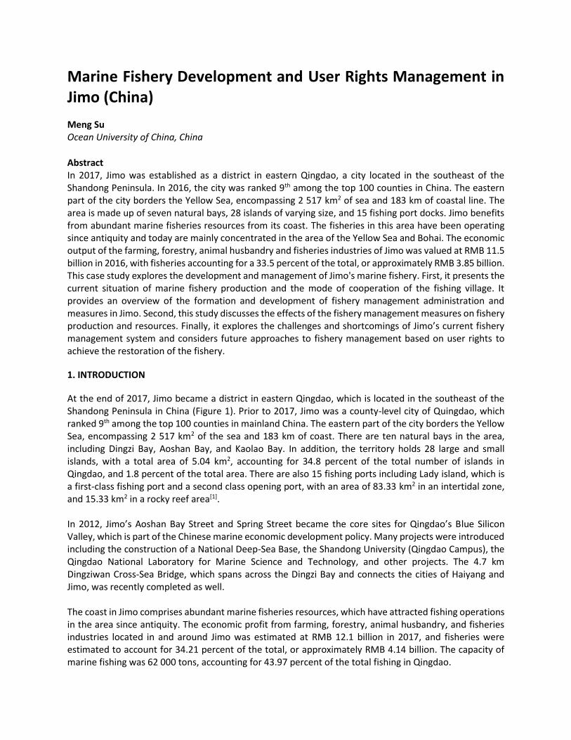
At the end of 2017, Jimo became a district in eastern Qingdao, which is located in the southeast of the Shandong Peninsula in China (Figure 1). Prior to 2017, Jimo was a county-level city of Quingdao, which ranked 9th among the top 100 counties in mainland China. The eastern part of the city borders the Yellow Sea, encompassing 2 517 km2 of the sea and 183 km of coast. There are ten natural bays in the area, including Dingzi Bay, Aoshan Bay, and Kaolao Bay. In addition, the territory holds 28 large and small islands, with a total area of 5.04 km2, accounting for 34.8 percent of the total number of islands in Qingdao, and 1.8 percent of the total area. There are also 15 fishing ports including Lady island, which is a first-class fishing port and a second class opening port, with an area of 83.33 km2 in an intertidal zone, and 15.33 km2 in a rocky reef area[1]. In 2012, Jimo’s Aoshan Bay Street and Spring Street became the core sites for Qingdao’s Blue Silicon Valley, which is part of the Chinese marine economic development policy. Many projects were introduced including the construction of a National Deep-Sea Base, the Shandong University (Qingdao Campus), the Qingdao National Laboratory for Marine Science and Technology, and other projects. The 4.7 km Dingziwan Cross-Sea Bridge, which spans across the Dingzi Bay and connects the cities of Haiyang and Jimo, was recently completed as well. The coast in Jimo comprises abundant marine fisheries resources, which have attracted fishing operations in the area since antiquity. The economic profit from farming, forestry, animal husbandry, and fisheries industries located in and around Jimo was estimated at RMB 12.1 billion in 2017, and fisheries were estimated to account for 34.21 percent of the total, or approximately RMB 4.14 billion. The capacity of marine fishing was 62 000 tons, accounting for 43.97 percent of the total fishing in Qingdao.
2
Jimo has an excellent geographical location and abundant fishery resources. It is an important production area for marine fishery in Qingdao. Through a field investigation in Jimo, we found that the fishing village has unique features in marine fishery production due to geographical and human differences, and the fisheries organization has accumulated rich experiences in marine fishery management. Based on these particularities, this study expounds an appropriate management system for the fishery in the Jimo area based on territorial user rights for fisheries and anticipates the future developments as well as possible obstacles for the management of this fishery.
Figure 1. The location of the Jimo District. Source: Arcgis.
1.1 Development of the marine fishery in Jimo
1.1.1 Overview of Jimo fishery village, fishing port, and fishery resources
The fishing period of small yellow fish, hairtail, Spanish mackerel, Chinese herring, mackerel, and wahoo in Jimo takes place from April to June, and the fishing period for jellyfish is from summer to winter. Since 1992, due to the depletion of resources, the burnt-end ark became the main fishing target. In 1993, there were approximately 100 perennial operating vessels, and fishing operations were carried out in the marine area around the Qianli Island. The rest of the vessels were mainly engaged in small bottom trawl production. The fishing area in Jimo is mainly offshore. Currently, there are four main offshore fishing grounds in Jimo. The southeastern fishery of Shidao is a crucial fishing ground; it is located at the intersection of the coastal stream of the south of the Chengshan Mountain and the warm current of the Yellow Sea in the north, which has led to the establishment of an excellent spawning and feeding ground for the cold-water fish and a wintering migration route of the bottom fish. Yanwei Fishing Ground is a migratory fishing ground where fish and shrimps enter and leave the Bohai Sea and the Yalu River during spring and autumn to lay eggs, feed bait and overwinter. They mainly produce carp, white croaker, prawns, and hawk claw shrimp, which mainly produces mackerel, white croaker, prawn and white-hair rough shrimp. The Haizhou Bay fishing ground is a spawning and bait field for different kinds of economically valuable fish and shrimp. Jimo's gill nets and bottom trawls often operate in this area. LVSI Fishing Ground is located in the brackish water of the North Jiangsu coast and the Yangtze River estuary freshwater low saltwater system, with the high saltwater system in the outer sea. It is rich in bait and is the working area of a large horsepower fishing boat in Jimo. There are 15 fishing ports in Jimo, including
Aoshan Port, Lady Island Port, Qigou Fishing Port, Qisan Fishing Port, Daguan Island, Xiaoguan Island Fishing Port, Tianheng Island Fishing Port, and Shandongtou Fishing Port. 1.1.2 Fishery population and community status in Jimo District The number of people working in the fisheries sector in Jimo went from 2 788 people in 1949 to 4 085 in 1953, 13 761 in 1987, and 39 875 in 2003, which accounted for 15 percent of the coastal population (Figure 2). There are five coastal towns engaged in fishery production, including Aoshanwei Town, Wenquan Town, Tianheng Town, Tianheng Island Provincial Tourism Resort, and Jinkou Town. The Aoshanwei Town, Tianheng Town, and Tianhengdao Provincial Tourism Resort are engaged in marine fishing, while the other two towns focus more on marine aquaculture. The Aoshanwei Town and Tianheng Town mainly have small fishing boats (less than 12 meters long). The resort is dominated by medium-sized fishing boats (about 23-24 meters long), which makes it the largest fishing village in Jimo. In 2017, Jimo had 92 coastal fishing villages and employed 23 296 marine fishery professionals (which represents a 7.60 percent drop compared to the previous year) and 2 090 females [1]. The fishermen are usually local villagers who come from a family tradition of fishermen. The wooden powered fishing boats are mainly small and medium-sized and are owned by the captain. Due to the high risk of operation, the difficult conditions, and the high labor intensity, there are practically no women working on the fishing boats. The captains also come from local villages and work full-time in fishing. The fishing period stretches from 100 to 120 days annually. Throughout the rest of the year, including off-season, they usually repair fishing vessels and fishing gear but do not engage in other employment. A small fishing boat employs 1-2 crew members, in addition to the captain, while a medium-sized fishing boat employs 8-9 crew members, all of which come from the local community. The annual net income of a medium-sized ship is about RMB 60-80 thousand, and for small boats, it is RMB 30-50 thousand, which represents the main source of fishermen's income. Because of the reduced fishery resources and high fuel costs, the majority of families have only one fishing vessel.
Figure 2. Fishery Labour of Jimo Marine Fishing from 1988 to 2017 (unit: person).
1.1.3 Catches of marine fishing in Jimo District In the early 1950s, the number of fishing vessels in Jimo increased annually and the fishing period grew from seasonal operations to part-time, rotational and perennial operations. In the late 1950s, owing to the reduction of marine resources, tools lagged behind, and catches were in an unstable condition; catches dropped to 3 038 tons in 1958. In the 1960s, various traditional catches were generally reduced
0
5000
10000
15000
20000
25000
30000
35000
40000
45000
19
88
19
89
19
90
19
91
19
92
19
93
19
94
19
95
19
96
19
97
19
98
19
99
20
00
20
01
20
02
20
03
20
04
20
05
20
06
20
07
20
08
20
09
20
10
20
11
20
12
20
13
20
14
20
15
20
16
20
17
Fishery Labor(person)
4
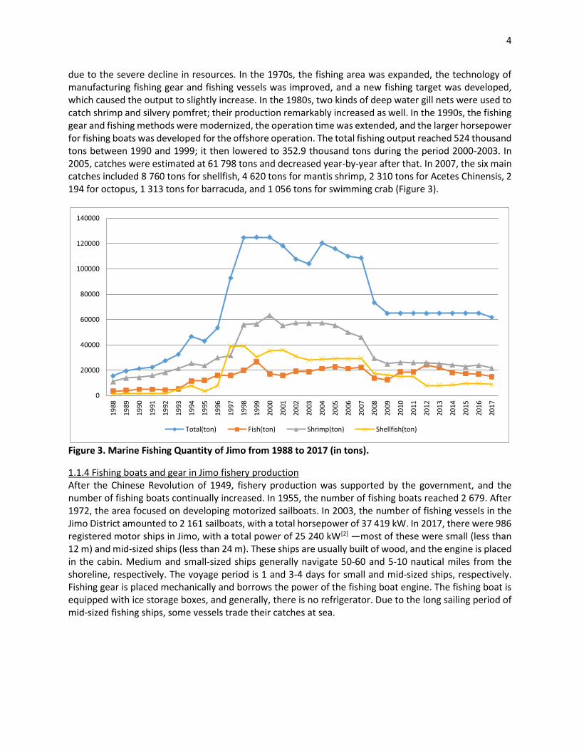
due to the severe decline in resources. In the 1970s, the fishing area was expanded, the technology of manufacturing fishing gear and fishing vessels was improved, and a new fishing target was developed, which caused the output to slightly increase. In the 1980s, two kinds of deep water gill nets were used to catch shrimp and silvery pomfret; their production remarkably increased as well. In the 1990s, the fishing gear and fishing methods were modernized, the operation time was extended, and the larger horsepower for fishing boats was developed for the offshore operation. The total fishing output reached 524 thousand tons between 1990 and 1999; it then lowered to 352.9 thousand tons during the period 2000-2003. In 2005, catches were estimated at 61 798 tons and decreased year-by-year after that. In 2007, the six main catches included 8 760 tons for shellfish, 4 620 tons for mantis shrimp, 2 310 tons for Acetes Chinensis, 2 194 for octopus, 1 313 tons for barracuda, and 1 056 tons for swimming crab (Figure 3).
Figure 3. Marine Fishing Quantity of Jimo from 1988 to 2017 (in tons).
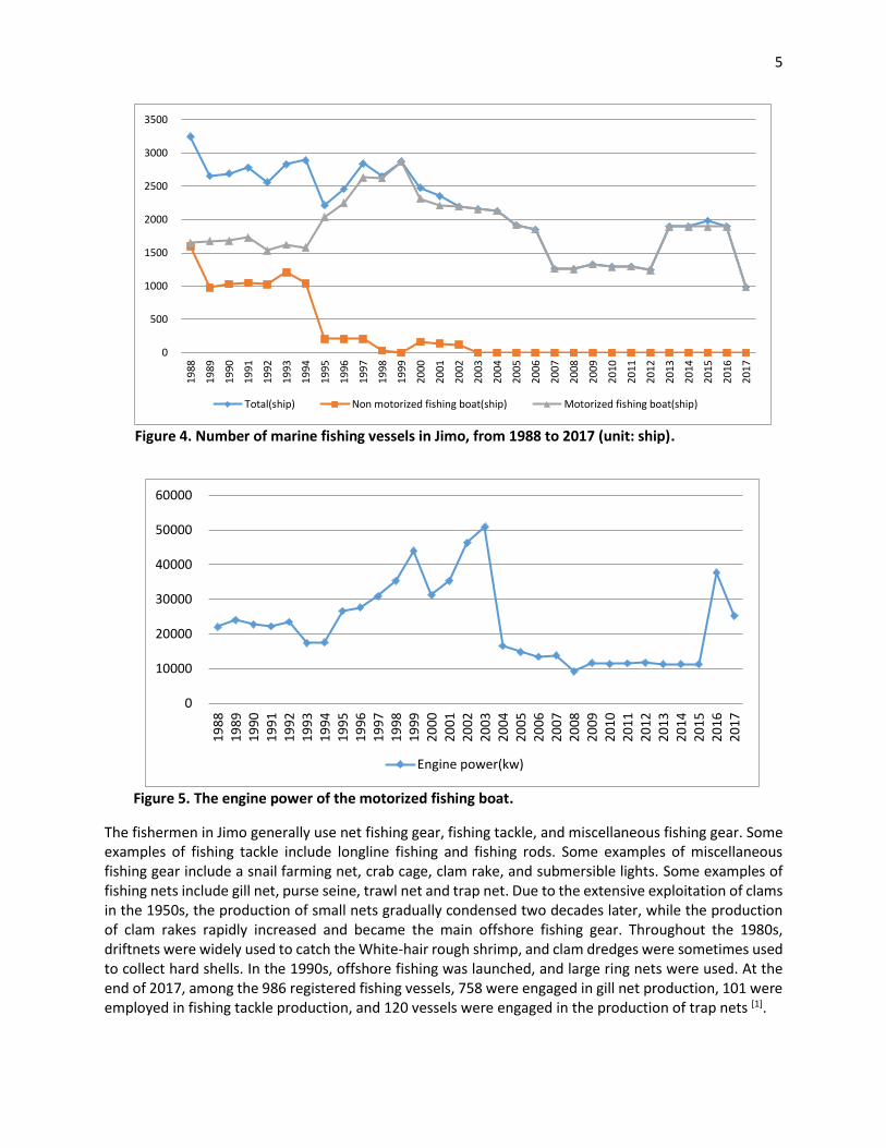
1.1.4 Fishing boats and gear in Jimo fishery production After the Chinese Revolution of 1949, fishery production was supported by the government, and the number of fishing boats continually increased. In 1955, the number of fishing boats reached 2 679. After 1972, the area focused on developing motorized sailboats. In 2003, the number of fishing vessels in the Jimo District amounted to 2 161 sailboats, with a total horsepower of 37 419 kW. In 2017, there were 986 registered motor ships in Jimo, with a total power of 25 240 kW[2] —most of these were small (less than 12 m) and mid-sized ships (less than 24 m). These ships are usually built of wood, and the engine is placed in the cabin. Medium and small-sized ships generally navigate 50-60 and 5-10 nautical miles from the shoreline, respectively. The voyage period is 1 and 3-4 days for small and mid-sized ships, respectively. Fishing gear is placed mechanically and borrows the power of the fishing boat engine. The fishing boat is equipped with ice storage boxes, and generally, there is no refrigerator. Due to the long sailing period of mid-sized fishing ships, some vessels trade their catches at sea.
0
20000
40000
60000
80000
100000
120000
140000
19
88
19
89
19
90
19
91
19
92
19
93
19
94
19
95
19
96
19
97
19
98
19
99
20
00
20
01
20
02
20
03
20
04
20
05
20
06
20
07
20
08
20
09
20
10
20
11
20
12
20
13
20
14
20
15
20
16
20
17
Total(ton) Fish(ton) Shrimp(ton) Shellfish(ton)
5
Figure 4. Number of marine fishing vessels in Jimo, from 1988 to 2017 (unit: ship).
Figure 5. The engine power of the motorized fishing boat.
The fishermen in Jimo generally use net fishing gear, fishing tackle, and miscellaneous fishing gear. Some examples of fishing tackle include longline fishing and fishing rods. Some examples of miscellaneous fishing gear include a snail farming net, crab cage, clam rake, and submersible lights. Some examples of fishing nets include gill net, purse seine, trawl net and trap net. Due to the extensive exploitation of clams in the 1950s, the production of small nets gradually condensed two decades later, while the production of clam rakes rapidly increased and became the main offshore fishing gear. Throughout the 1980s, driftnets were widely used to catch the White-hair rough shrimp, and clam dredges were sometimes used to collect hard shells. In the 1990s, offshore fishing was launched, and large ring nets were used. At the end of 2017, among the 986 registered fishing vessels, 758 were engaged in gill net production, 101 were employed in fishing tackle production, and 120 vessels were engaged in the production of trap nets [1].
0
500
1000
1500
2000
2500
3000
3500
19
88
19
89
19
90
19
91
19
92
19
93
19
94
19
95
19
96
19
97
19
98
19
99
20
00
20
01
20
02
20
03
20
04
20
05
20
06
20
07
20
08
20
09
20
10
20
11
20
12
20
13
20
14
20
15
20
16
20
17
Total(ship) Non motorized fishing boat(ship) Motorized fishing boat(ship)
0
10000
20000
30000
40000
50000
60000
19
88
19
89
19
90
19
91
19
92
19
93
19
94
19
95
19
96
19
97
19
98
19
99
20
00
20
01
20
02
20
03
20
04
20
05
20
06
20
07
20
08
20
09
20
10
20
11
20
12
20
13
20
14
20
15
20
16
20
17
Engine power(kw)
6
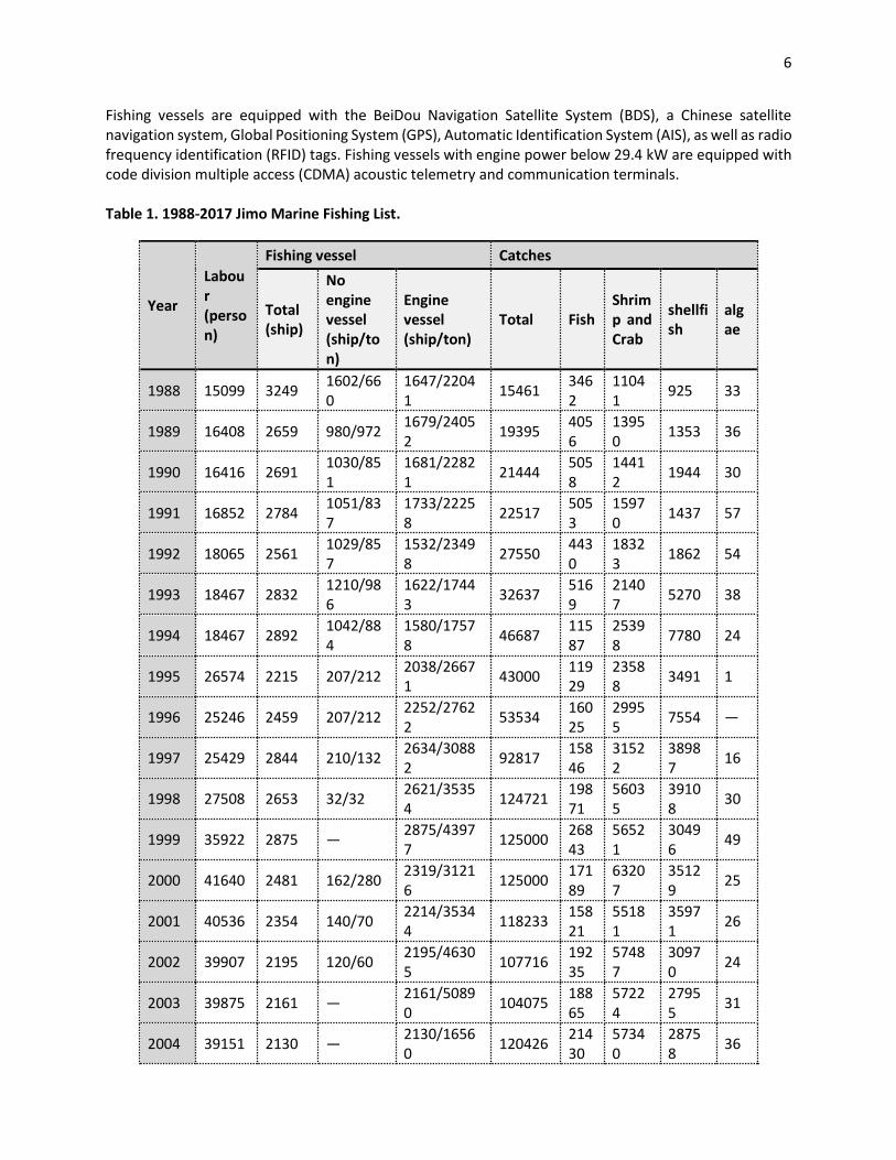
Fishing vessels are equipped with the BeiDou Navigation Satellite System (BDS), a Chinese satellite navigation system, Global Positioning System (GPS), Automatic Identification System (AIS), as well as radio frequency identification (RFID) tags. Fishing vessels with engine power below 29.4 kW are equipped with code division multiple access (CDMA) acoustic telemetry and communication terminals. Table 1. 1988-2017 Jimo Marine Fishing List.
Year
Labour (person)
Fishing vessel Catches
Total (ship)
No engine vessel (ship/ton)
Engine vessel (ship/ton)
Total Fish Shrimp and Crab
shellfish
algae
1988 15099 3249 1602/660
1647/22041
15461 3462
11041
925 33
1989 16408 2659 980/972 1679/24052
19395 4056
13950
1353 36
1990 16416 2691 1030/851
1681/22821
21444 5058
14412
1944 30
1991 16852 2784 1051/837
1733/22258
22517 5053
15970
1437 57
1992 18065 2561 1029/857
1532/23498
27550 4430
18323
1862 54
1993 18467 2832 1210/986
1622/17443
32637 5169
21407
5270 38
1994 18467 2892 1042/884
1580/17578
46687 11587
25398
7780 24
1995 26574 2215 207/212 2038/26671
43000 11929
23588
3491 1
1996 25246 2459 207/212 2252/27622
53534 16025
29955
7554 —
1997 25429 2844 210/132 2634/30882
92817 15846
31522
38987
16
1998 27508 2653 32/32 2621/35354
124721 19871
56035
39108
30
1999 35922 2875 — 2875/43977
125000 26843
56521
30496
49
2000 41640 2481 162/280 2319/31216
125000 17189
63207
35129
25
2001 40536 2354 140/70 2214/35344
118233 15821
55181
35971
26
2002 39907 2195 120/60 2195/46305
107716 19235
57487
30970
24
2003 39875 2161 — 2161/50890
104075 18865
57224
27955
31
2004 39151 2130 — 2130/16560
120426 21430
57340
28758
36
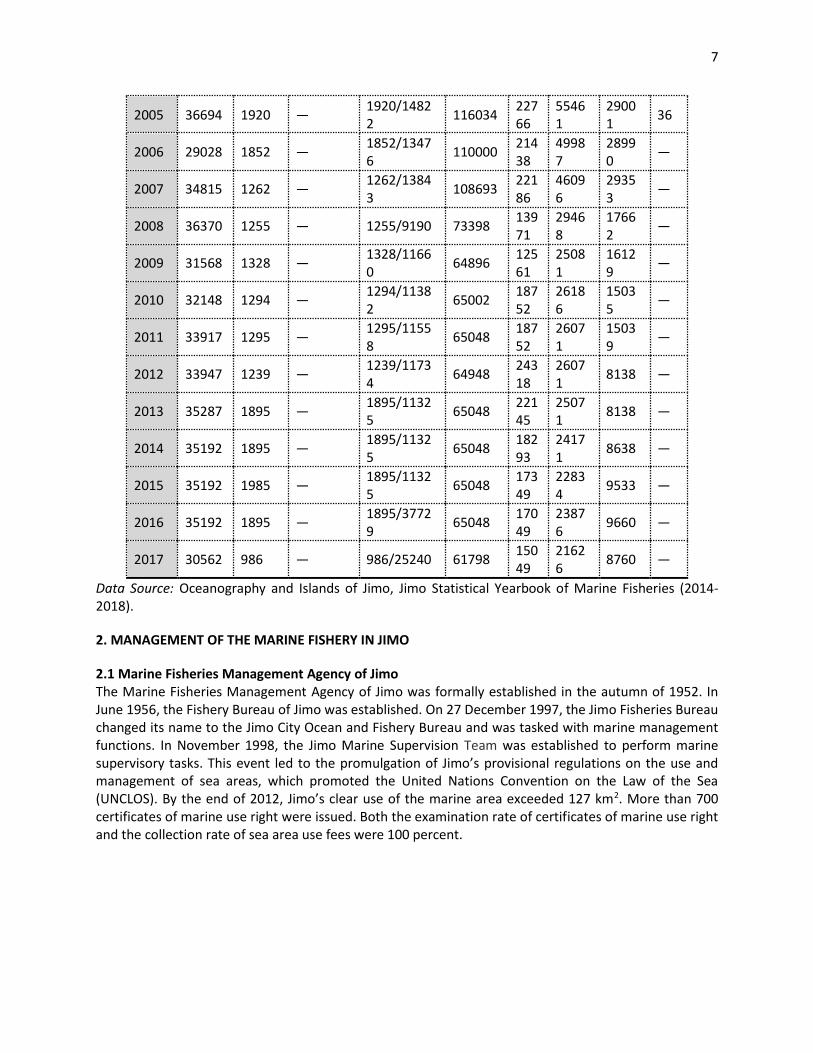
7
Data Source: Oceanography and Islands of Jimo, Jimo Statistical Yearbook of Marine Fisheries (2014-2018).
2. MANAGEMENT OF THE MARINE FISHERY IN JIMO
2.1 Marine Fisheries Management Agency of Jimo The Marine Fisheries Management Agency of Jimo was formally established in the autumn of 1952. In June 1956, the Fishery Bureau of Jimo was established. On 27 December 1997, the Jimo Fisheries Bureau changed its name to the Jimo City Ocean and Fishery Bureau and was tasked with marine management functions. In November 1998, the Jimo Marine Supervision Team was established to perform marine supervisory tasks. This event led to the promulgation of Jimo’s provisional regulations on the use and management of sea areas, which promoted the United Nations Convention on the Law of the Sea (UNCLOS). By the end of 2012, Jimo’s clear use of the marine area exceeded 127 km2. More than 700 certificates of marine use right were issued. Both the examination rate of certificates of marine use right and the collection rate of sea area use fees were 100 percent.
2005 36694 1920 — 1920/14822
116034 22766
55461
29001
36
2006 29028 1852 — 1852/13476
110000 21438
49987
28990
—
2007 34815 1262 — 1262/13843
108693 22186
46096
29353
—
2008 36370 1255 — 1255/9190 73398 13971
29468
17662
—
2009 31568 1328 — 1328/11660
64896 12561
25081
16129
—
2010 32148 1294 — 1294/11382
65002 18752
26186
15035
—
2011 33917 1295 — 1295/11558
65048 18752
26071
15039
—
2012 33947 1239 — 1239/11734
64948 24318
26071
8138 —
2013 35287 1895 — 1895/11325
65048 22145
25071
8138 —
2014 35192 1895 — 1895/11325
65048 18293
24171
8638 —
2015 35192 1985 — 1895/11325
65048 17349
22834
9533 —
2016 35192 1895 — 1895/37729
65048 17049
23876
9660 —
2017 30562 986 — 986/25240 61798 15049
21626
8760 —
8
Jimo Marine Inspection Team
Fishing Technology Station
Management Committee of the
Aquaculture Industrialization Base of
the National Marine Science Research Center
Fishery and Fishing port Supervision and Management Station
Oceanic and Fisheries Bureau of Jimo District
Jimo District Government
Oceanic and Fisheries Bureau of Qingdao
Aoshanwei Town
Wenquan Town Tianheng Town Tianheng Island Provincial
Tourism Resort
Jinkou Town
Figure 6. Administration relationship of the Jimo Oceanic and Fisheries Bureau.
2.2 Management of marine fishery user rights in Jimo
2.2.1 Fishery user rights management based on fishing license A fishing license must be approved by the Chinese government for fishermen to engage in fishing operations. China initiated the fishing licensing system in 2002. In 2007, the property law declared the rights of fishery farming and fishing rights as a usufructuary right, which is of great significance for protecting the legitimate rights and interests of marine fisheries[3]. The licensing system includes a fishing licence, a ship inspection certificate, and a ship registration certificate. The government promoted the "three certifications in one" reform, implemented the reform on fishery inlands by 2016, and carried out the reform research of "three certificates in one" in small-sized fishing vessels. A fishing license is divided into seven categories: marine fishing license, public sea fishing license, inland fishing license, special (chartered) fishing license, temporary fishing license, foreign fishing boat fishing license, and fishing auxiliary ship license. A license certifies, amongst other things, the type of operation, the territorial area, the time limit, the quantity and the specifications of fishing gear, and fishing species. The species and the area of fishing should be approved on the license. The license also specifies the engine power, length, tonnage, and the owner’s individual details of the fishing vessel. Within the territorial sea, fishing vessels must not operate at cross-border regions, and fishing gear other than those specified on the license cannot be used. Licenses cannot be sold, leased, or transferred to other individuals. The validity period of the marine fishing license and the inland fishing license is five years. The validity period of other types of fishing licenses is determined by actual needs. However, it does not exceed three years. A fishing license with over one-year validity is annually reviewed. Within the territorial sea, a license is generally issued by the fishery department of the local government, which is also responsible for the annual review. The age of the various types of fishing vessels is also regulated; fishing vessels that exceed the age limit are not validated. In addition to the use of licenses for fishing gear management, the management agency has also implemented a minimum mesh size system for the use of fishing gears and transitional fishing gears. In order to strengthen the management of fishing gear and protect marine fishery resources, with the help of scientific researchers and the practice of fishing production, the Ministry of Agriculture issued “the Notice on the Implementation of the Minimum Net Size System for Marine Fishing and transitional Fishing Gear” in December 2013, which regulated the use of fishing gear.
9
2.2.2 Fisherman's qualification certificate is a threshold for fishing “The Regulations on the Issuance of Marine Fisheries in the People's Republic of China” divides the fishery crew into professional crew members and ordinary crew members. The professional crew members are the drivers, engineers, electricians, and radio personnel. According to the specific parameters of the fishing vessel, such as the gross tonnage, engine power, and other indexes, the number of crew members and the corresponding competency certificates should be provided. “The Regulations of the People's Republic of China on the Examination and Issuance of Certificates for Professional Basic Training of Ordinary Seafarers on Fishery Vessels” declares that the ordinary crew should obtain the “Certificate of Professional Training for Fishermen's General Crew” required for work permission. According to the above-mentioned policies, the fishery management system has basically established itself around “fishing boats, fishing gear, and fishermen”, and formed the access threshold of fishery in the offshore area.
2.3 Other marine fishery management policies in the Jimo
2.3.1 A double-control system for fishing vessel Since 1987, China implemented a “double-control system” for marine fishing, which mainly controls the number of fishing vessels and their engine power, and proposed a "double-control" target during 1986-1990, 1991-1995, 1996-2000, and 2003-2010. In 2002, the Ministry of the People's Republic of China issued the “Interim Provisions on the Retirement of Fishery Vessels”. For the first time, the fishing vessels that reached the age of scrapping in China were compulsorily scrapped. The government supplied the subsidy to help fishermen change their jobs. Under the “double-control” policy, all fishing vessels were motor sailing vessels, in which 2 161 fishing vessels carried 16 580 tons, with a total power of 37 419 kW in 2003. In 2012, Jimo had 986 motor vessels, with a loading capacity of 7 768 tons, and total power of 25 240 kW. The number of vessels was reduced by nearly 50 percent. Both the total loading capacity and total power decreased. 2.3.2 Fishery oil price subsidy system The subsidy for the fishery oil price is an important policy that supports fisheries and increases profits. It is also the broadest policy supporting fisheries that the government has implemented since 2006. The Jimo district enjoys diesel subsidies for fishermen and fishing enterprises engaged in offshore fishing and breeding, and that use mobile fishing vessels. Since 2015, these subsidies were adjusted by taking into consideration factors such as the age of the ship and the ecological restoration. Domestic fishing boats are classified for oil subsidies according to the type and the size of the vessel. The scale of subsidies for large-scale and medium-sized fishing vessels has gradually decreased, and subsidies for small-scale fishing boats have remained the same. Subsidies can thus be considered a cost-sharing mechanism for fishermen. Old fishing vessels that reached the age limit were not subsidized in 2018. The double-bottom trawl, sailing net, and single-vessel surrounding net with a large fishing intensity, which have serious negative effects on resources, will not be subsidized in 2020. 2.3.3 Summer fishing moratorium system In order to protect fishery resources, the summer fishing moratorium system was implemented, and the fishing season was clearly defined. The fishing season, time, and grounds were clearly adjusted to the changes in Jimo’s ban on certain fishing periods and fishing areas. In 2017, the fishing period was changed from 1 June to 1 May and lasts until 1 September. The fishing season has effectively protected the reproduction and growth of most of the major economic species, improved the quality of catch, and increased the sales price thanks to the larger sizes of the fish. At the same time, the system reduces the fishing time and the production cost. According to the statistics, every 15 to 44 kW of fishing vessels can
save RMB 14 thousand, and 15 kW of fishing boats can save RMB 8 thousand. However, despite the risk of being severely punished, some small fishing vessels have been prone to illegal fishing during the moratorium period because of the high seafood prices. After the moratorium, increased competition weakened the conservation results of the moratorium season. Fishing inspectors remain at sea for 24 hours and conduct both circuit inspections and surprise inspections to curtail illegal fishing. Combining the fishing moratorium season management with the fuel subsidies would be helpful to incentivize fishermen to engage self-control and to refrain from illegal behavior. Working groups are stationed at important ports and fishing villages to block the entry of illegal fishing boats. This allows them to coordinate and keep abreast with the dynamics of fishing vessels. The Ocean and Fishery Bureau also conducts crew training courses in coastal towns and villages. They train 150 crew members and ordinary crew members in fishery safety production, laws and regulations, and relevant business skills. Those who do not participate in training courses or fail the training exams are not eligible to receive certificates and are not allowed to engage in fishing production. The summer fishing moratorium system also stipulates that special fishing can be carried out for special species of fish, such as prawns and jellyfish. In the sea area of Jimo, the period of 20 July to 30 July is the fishing season of jellyfish, and the period of 20 August to 30 August is the fishing season for prawns. Fishing vessels can legally operate according to the approved scope and fishing gear on the fishing licences. 2.3.4 The system of fishery resources proliferation and protection fee In the middle and late 1980s, China began to gradually implement the fishery resources proliferation and protection fee. In accordance with the “measures for the use of the collection and use of the protection fee for the proliferation of fishery resources”, all units and individuals who have captured natural growth and artificial proliferation of aquatic animals and plants in the sea area under our jurisdiction must pay the protection fee for the proliferation of fishery resources. The collection and use of fishery resources fees should be based on the principle of "Taking it from fishing, and using it for fishing." The charge of proliferation protection can be used as an economical means to limit fishing investment and to reduce the fishing intensity. It can be used as the cost of the release of fishery resources, and it can also support the law enforcement expenditure of local fisheries administration departments. In order to further reduce the burden of enterprises, especially small and micro enterprises, the State Council approved the suspension of the collection of fishery resources proliferation and protection fees from 2015. In 2018, Jimo’s fishery resources fund proliferation was 2.38 million yuan, of which the central capital paid 1.8 million yuan, and Qingdao municipal government paid 5.8 million yuan. This helped restock the Chinese shrimp to 86.11 million tails, Japanese shrimp to 68.08 million, three wart swimming crab to 8.337 million, flounder fish to 335 000 tails, a total of 162.862 million units. The released seed was purchased byways of bidding.
2.4 Fishery monitoring and controlling in Jimo The Fishery and Fishing port Supervision and Management Station is responsible for the monitoring and controlling of Jimo fisheries. The station is responsible for:
1) Promoting and implementing fishery laws and regulations, supervising and administrating fishing, fishing ports, and fishing vessels.
2) Implementing and supervising fishing license and the summer fishing moratorium. 3) Dealing with maritime accidents in fishing ports and maritime disputes. 4) Undertaking the registration, inspection, and issuance of various documents for fishing
vessels, organizing the rescue of fisheries, supervising and managing production safety. 5) Protecting aquatic wildlife and supervising and managing fishery reserves. 6) Contributing to the management of fishing vessel radio stations.
7) Guiding the energy-saving and emission reductions efforts of fishing vessels. Financial penalties are usually exerted for violations of regulations. The 14 kinds of illegal activities are reprimanded through deductions from the fishing oil price subsidy –six of which are deducted from annual oil price subsidies, and eight of which are deducted below 70 percent of oil price subsidies. Due to the high penalties and frequent patrols from 13 monitoring vessels, there are fewer violations than before, but the problem has not disappeared. While the catches are confiscated and dumped back into the sea, violating fishing boats are also temporarily detained. Each community has one fishery assistant who reports directly to the Jimo Fishery Supervision Station. The fishery supervision station allocates funds according to the size and quantity of the vessels managed by the assistant. The fishery assistant cooperates with the supervision station and is mainly responsible for:
1) Becoming familiar with the basic situation of fishing vessels and crews, maintaining communication between them, and ensuring positive dynamics between them.
2) Promoting laws and regulations, system measures and other related regulations on fishery safety production. Conveying the requirements and relevant information on safe productions to the fishing vessel owners and the captain in a timely manner.
3) Ensuring that fishing vessels are equipped with safety gear such as fire protection and life jackets, as well as safety terminal equipment such as communication and navigation devices. Overseeing that fishing vessels engage in mutual insurance and that crew members lacking a certificate of competency attend to this problem by undergoing their required training.
4) Communicating the weather warning information to fishing boats in due time and guiding vessels to take shelter from wind and other harsh weather.
5) Carrying out safety production inspections by relevant departments, conducting regular inspections of fishing port terminals, conducting timely investigations into hidden dangers, uncovering and correcting fishing violations.
6) Cooperating with entities organizing fishing vessel inspections, crew trainings, emergency rescues, and the management of the summer moratorium.
7) Ensuring a positive relationship with the daily inspection teams of the coastline. If any illegal use of the sea area, illegal reclamation, pool building and damage to the marine environment are discovered, the case shall be reported to the town street and the competent authorities in a timely manner.
The fishing station is also responsible for the safety inspection of fishing vessels during the fishing moratorium season. The medium and large fishing vessels must be repaired in the dock, and the small fishing boats should be checked onshore. The rescue and escape equipment of fishing vessels is the primary focus of the inspection. The inspection fee is free, and the cost of repair is borne by fishermen. After the moratorium season, fishing boats continue to undergo random inspections. In recent years, fishing vessels have had fewer accidents. The accidents that were recorded were mainly due to mechanical failures or where the crew fell into water because of bad weather (with the fishery administration station actively taking part in the rescue operations). The compensation is paid by the insurance. The owner or operator of the fishing vessel should have employer liability insurance for fishery mutual insurance for the employee. The total insurance amount is 2 000 yuan per year. Employers only need to pay 740 yuan per year for employees, and the rest is paid by the government. If the fishermen are injured and killed, the maximum compensation is 320 thousand for the fishery aid insurance. The captain can also choose commercial insurance to increase the compensation amount. Those who participate in fishery aid insurance can enjoy free crew training, life jacket equipment, liferaft
12
maintenance, low-interest shipowner finance and other fishing policies which are paid for by the government. In view of safety considerations, fishing vessels should be organized in the form of free cooperation of cooperatives or towns (streets) and villages. It is required that fishery vessels form teams when they go out at sea; at least three vessels from the same town or village must fish together. The fishery vessels in a team have the responsibility of mutual assistance.
3. CHALLENGES FACING THE MANAGEMENT OF MARINE FISHERIES IN JIMO
3.1 Illegal operations of other province fishermen across the sea territory In recent years, local and central governments in Shandong province have invested a large number of funds strengthening the conservation of fishery resources, which has enabled the recovery of many offshore fishery resources as well. The fishing period in Jimo saw the arrival of fishing boats from many provinces including, for instance, Hebei and Liaoning, seeking to compete with the local fishermen for the limited fishery resources. When it became evident that their fishing grounds had been occupied by foreign boats, the local fishermen attempted to squeeze out their competition, thereby causing various fishing disputes. Fishing vessels operating in the sea area of the coastal provinces must act in accordance to the fishing license. The “Measures for the Implementation of Fisheries Law of Shandong Province” stipulates that fishing vessels coming from other provinces and municipalities to engage in fishing in another jurisdiction must apply for a fishing license which must be approved by the fishery administrative department of the provincial department. It is common for fishing boats from Liaoning province to enter the Jimo fishing area illegally. The hull and horsepower of their fishing boats are much greater than the fishing boats from Jimo, which creates high competitive pressure for the locals. All foreign vessels entering the Jimo fishing area have more than 300 horsepower and can have up to 10-12 vessels operating in a single team. These teams have caused a great deal of difficulty for local fishing inspection operations. Furthermore, local fishermen have complained that the local fishery inspection equipment lags behind and that the province lacks an effective coordination mechanism which makes monitoring difficult and sometimes ineffective.
3.2 Land occupied by project development The ongoing developments in Jimo, such as the China Blue Silicon Valley, National Marine Science and Technology Laboratory, Deep-Sea Base, Shandong University (Qingdao Campus), Qingdao National Marine Science Research Center, Aquatic Seedling Industrialization Base, Qingdao Yangfan Shipbuilding, Tianhengdao Provincial Tourism Resort, and the Huaneng Wind Power Project, have meant that some fishing villages are facing land occupations, thus forcing some fishermen to change profession and decreasing the number of fishing villages altogether. Due to the shortage of fishery resources and the increase in oil prices, fishing costs have risen, thus creating high vulnerability for fishermen’s incomes, which, in some cases, have decreased. These land expropriations have given way to considerable compensations, housing resettlements and an overall better standard of living for fishermen. Thus, excluding some fishermen who are reluctant to leave, many fishermen do not take issue with these projects and, on the contrary, have taken this opportunity to retire. Due to their old age and lack of alternative skills, the majority of them have not engaged in other types of work.
3.3 The contradiction between fishery management policies In order to protect and restore fisheries resources, China implemented the fishing licence system in 2002, the control over horsepower and total tonnage in 1987, as well as other input controls. Similarly, China adopted the summer fishing moratorium system as well as artificial proliferation and release fees, which led to increased fishery monitoring and controlling. However, despite these efforts, the degradation of fishery resources did not improve, especially in the areas near the coast. In addition, as oil prices
13
increased, so too did fishery production costs, which put downward pressure on fishermen’s income. The phenomenon of "more fishing, more losses" motivates fishing vessels to stop at the harbor during favorable weather conditions of non-prohibited fishing periods. Thus, the production of fisheries has decreased and has left the future of fishermen uncertain. In order to ensure the normal operation of fishery production, the state has introduced a series of policies for fishing and fishery, such as the fishery oil price subsidy policy, the fishery resources proliferation and release fees exempting policy, the ship inspection fees exempting policy, and the fisherman' mutual insurance subsidy policy. These policies have reduced the production cost of fisheries and decreased the number of fishermen that were suspended from fishing. The implementation of the oil price subsidy policy has led to some contradictions between the different policies. For example, some old-age fishing vessels deferred scrapping in order to obtain oil price subsidies, directly affecting the double-control policy for fishing vessels and the target of reducing the fishing intensity policy. For this reason, the Ministry of Agriculture of the People's Republic of China refined the target of subsidies and subsidy standards in 2015. The subsidies for the livelihood of fishing vessels remained unchanged, while the standard of subsidy was lowered year-by-year.
1.Resources deterioration
2.oil prices rising 3.high costs and
less catches
4.income declining
5.the difficulty of living and production
6.oil price subsidy
Figure 7. The vicious cycle leading by the fisheries policies.
3.4 Management Recommendations At present, marine fisheries management in the Jimo area mainly consists of a fishing permit system, with a mid-summer fishing moratorium and a variety of fees for the protection of marine resources. With the goal of restoring the maturity and stability of the Jimo coastal ecosystem, the policy recommendations for achieving sustainable fisheries include:
1) Expanding the fishing permit system, implementing a ‘double control’ system for fishing vessels (regulating both the number of fishing vessels and their engine power), reducing fisheries fuel subsidies, and increasing subsidies for individuals who leave fishing to work in other industries, all of which can reduce the fishing intensity.
2) Expanding the mid-summer moratorium and reducing illegal fishing during the moratorium period by enforcing cooperation with the fishing quota system to avoid excessive competition immediately after the moratorium period, while increasing the effectiveness of monitoring and enforcement.
3) Cracking down on the exploitation of the abundant marine resources that can be found in the numerous gulfs along the 180 km Jimo coastline by fisherman looking to supplement their income during the moratorium.
14
4) Developing an offshore aquaculture industry to increase the supply of seafood and reduce fishing pressure on coastal resources.
5) Management agencies should strengthen fisheries enforcement and reduce cross-regional illegal fishing.
6) Increasing the protection and restoration of coastal fishery resources; this would ensure that the fishermen feel that they are getting value for the marine resources protection fee.
CONCLUSION
Marine fisheries management in the Jimo District has established entry thresholds for fishing vessels, fishing gear, and fishermen. A fishery user right management system based on fishing licenses is established as part of a fishery production input control. The license has restrictions in terms of fishing areas, fishing gear, fishing species, and time limits. Currently, the management of the Jimo District has not implemented the fishery resources, fishery resource assessment, and the fishing quota systems. Fisheries management on output control has not yet been carried out. In 2017, the Ministry of Agriculture of the People's Republic of China selected Shandong province and Zhejiang province as pilots for the implementation of quota fishing. The quota fishing system will be gradually implemented in the future. The majority of the fishermen in Jimo are local people, who have been engaged in fishery production for generations, inheriting fishery production skills from their ancestors. The fisheries and fishing villages improve the livelihoods of locals while reinforcing their cultural heritage. Qingdao also has a regional development plan for the protection of traditional fishing villages. For example, the Fengjiahe village in the Jimo District is planned to be a fishing village. Therefore there is no requirement for this fishing village to reduce the number of fishing ships and fishermen. However, most of the fishermen's offsprings lack the necessary skills and motivation to engage in fishing. Fishery production and fishing village culture are facing sustainability problems as well. In order to restore coastal fishery resources, the authorities have introduced policies to reduce the number of vessels with small horsepower. Better horsepower and improved hull material will lead to bigger and more powerful ships, thereby reducing the number fleets and encouraging offshore fishing. However, these powerful ships have also created new demand for offshore fishing technology, production safety, and cooperation among fishermen. Fisheries authorities require technical support to train the fishermen. But in order to better adapt to the rise in offshore fishing, the authorities have encouraged and supported the formation and development of various types of fishery cooperation organizations. With the continuous changes of fishery production, the marine fishery management in Jimo District will face more new challenges.
REFERENCES
[1] Jimo Historical Records Office. 2014. Marine and island records of Jimo [M]. Jimo Marine and Fishery Bureau. Jinan: The Yellow River Press. [2] Jimo marine and Fishery Bureau. Jimo Statistical Yearbook of Marine Fisheries, 2014-2018. [3] Jiang, X.Z, Liu, T.Y, and Su, C.W. (2014). China's marine economy and regional development. Marine Policy, 50: 227-237 [4] Su, M. (2015). Study of Coastal Small-Scale Fisheries Management Pattern Based on the Ecosystem Approach to Fisheries (PhD Dissertation). Ocean University of China. [5] Su, M. (2016) Preliminary analysis of the Jimo coastal ecosystem with the ecopath model. Journal of Ocean University of China, 15(6).
15
Managed Access: A Rights-Based Approach to Managing Small Scale Fisheries in Belize
1 Virginia Isabel Martinez, 2Adriel Casteñada, 3 Mauro Gongora, 4Beverly Wade and 5Nicanor Requena
1-4. Belize Fisheries Department, Princess Margaret Drive, P.O. Box 148, Belize City, Belize C.A. 5. Environmental Defense Fund, Punta Gorda Town, Belize, C.A. Abstract Belize’s commercial and subsistence fisheries are important for the livelihoods of approximately 2 800 fishermen, their families and coastal fishing communities. Belize’s Fisheries were considered an open access fishery up until 2011. The threat of resource depletion became clear when fishermen’s catches gradually declined. July of 2011 marked a turning point in the history of fisheries management in Belize, as the Belize Fisheries Department (BFD) in partnership with Toledo Institute for Development and Environment (TIDE), Wildlife Conservation Society (WCS) and Environmental Defense Fund (EDF) pioneered, at two of its marine reserves, the implementation of a rights-based approach to fisheries management known as Managed Access. The program was designed to empower traditional fishers by ensuring greater participation in the decision-making process which impacts their livelihood, and by improving the benefits to be derived from the fish stocks in terms of increased fish landings, reduction in fishing effort, larger size classes and increased prices and revenues. In addition, in the long term, there will be benefits accrued to the ecosystem, which will contribute to the maintenance of the overall health and sustainability of the Belize Barrier Reef System. Key to the success of this program are several components which include, but are not limited to: improvements in the licensing/registry system and process; a good monitoring and fishery-dependent catch data collection program; a dedicated presence of enforcement personnel and use of new enforcement technologies; and most importantly, the greater active involvement of fishers themselves in the program via fishing area based committees. All of which, coupled with an extensive social marketing campaign and consultation process, has yielded significant success and benefits for the resources as well as the stakeholders. Initially, Managed Access sought to complement Belize’s successful marine reserve network with a system of limited access that would allow access to fishing within the general use zone of the marine reserve only to its bonafide fishermen. Managed Access eventually metamorphosed, and five years after the implementation at the pilot sites, the positive results and consultation process triggered the expansion of the program beyond just the initial proposal to roll out to the marine reserve network. Thus, in June of 2016, Managed Access was rolled out to the entire territorial waters of Belize and it now secures tenure for fishermen to fish in two of eight designated fishing areas, called TURFs (Territorial User Rights for Fishing), with the additional option of Area 9 that is designated for deep-sea fishing. In the process of the national expansion of Managed Access, The Belize Fisheries Department Managed Access Task Force evolved into the Managed Access Working Group (MAWG), which now incorporates a broader array of stakeholders. The establishment of the MAWG was realized in order to have a better participatory intervention of both stakeholders and technical capacities that would better guide the expansion under an ecosystems based approach. Keywords: Rights-based management, Belize, Open access, Fisheries Management tool, Managed Access, TURF, small-scale fisheries
1. INTRODUCTION
1.1 Description of the fishery Belize is located between 15° 52' 9" and 18° 29' 55" N and 87° 28" y 89° 13' 67" W with a territory of
16
22 965 km2, including 688.94 km2 of islands and an Exclusive Economic Zone (EEZ) of 35 000 km2. Bordering to the north of Belize is Mexico with Guatemala to the west and south and facing the Caribbean Sea to the east (Figure 1). Belize is blessed with the second-longest barrier reef in the world that is approximately 269 km long, with a shallow lagoon between the coast and the barrier reef, which includes three offshore atolls with shallow inner lagoons. Inside the reef, the water is rarely deeper than a few metres, but beyond the offshore areas drop off, it plummets to between 1 000 to 4 000 feet depth. The combination of warm, shallow bays and lagoons, mangrove cayes, barrier reef and abyssal depths form ideal habitats for numerous species of marine life, including the spiny lobster, queen conch and several species of finfish making it one of the more productive fisheries in the region.
Figure 1. Country of Belize and Management Zones. Bordered by Mexico, Guatemala and the Caribbean Sea. Source: Adriel Enrique Castañeda 2009. Analysis Bioeconomico de la pesquería de Langosta, Panulirus argus, de Belice. Thesis de Maestría, El Colegio de La Frontera Sur.
The Belize Barrier Reef System is divided into three distinct reef zones: a) North Zone, with approximately 46 km of shallow reefs from “Rocky Point” to “Gallows Point” with very developed reef systems that are almost continuous and with canals at certain points; b) Central Zone, with almost 91 km of shallow reefs from “ Gallows Point” to “Gladden Spit” with the more developed and continuous reefs; c) Southern Zone, with 10km of shallow reefs from “Gladden Spit” to “Sapodilla Cayes” described by less continuous and developed reefs (Burke, 1982; Mcfield, 2001). Therefore, for management purposes, the coast of Belize is divided into three provinces (north, central and south) and these are subdivided into six fishing areas each with a mosaic of benthic habitats (see Figure 1). The commercial fishing industry of Belize is characterized as a small-scale artisanal fishery that focuses mainly on lobster (Panulirus argus), conch (Strombus gigas), and various species of finfish and other emerging fisheries such as sea cucumber, stone crab and sharks. The fishing fleet is composed of vessels of two types: wooden sailing sloops and skiffs. The sailing sloops, mainly with an auxiliary outboard engine
17
of 40 horsepower (hp), have a capacity of approximately eight canoes and ten divers and are equipped with an icebox to preserve catch. Their duration at sea varies between six to ten days depending on the amount of ice carried, the catch, weather conditions and food supply among others. On the other hand, the skiffs, which are 23-25 feet in length and have crews of one to four fishers, are made of fiberglass and use engines ranging from 15 to 115 hp. Their fishing trips mostly have a duration of one day but might last up to five days for fishers with fishing camps. Fishing for lobster and conch is done with free diving to depths between six to 20 meters. Commercial fishing with the use of SCUBA is prohibited by law. The Belize Fisheries Department has kept a registry since 1997 of the number of fishermen that engage in commercial fishing. Records indicate a steady rise in number from 1 359 fishers in 1997 to its peak of 2 829 fishers in 2015 (Figure 2). This rapid increase in the numbers of fishers was due to the open-access nature of the fishery, which had limited criteria for obtaining a license and engaging in fishing. However, the numbers of registered fishers have started to decline since the implementation of Managed Access in 2016 at the National level, which instituted measures to ensure that only bonafide fishers can obtain a license.
Figure 2. Number of registered fishers in Belize from 1997 to 2017. Source: Belize Fisheries Department. Open-access nature of the fishery has led to uncontrolled increase
The Managed Access Program, although expanded nationally in 2016, was initially piloted in July 2011 at Glover’s Reef Marine Reserve (GRMR) on Glover’s Reef Atoll and Port Honduras Marine Reserve (PHMR) in the southern seas off Punta Gorda Town. These two pilot sites that were identified in 2011 met the following criteria: 1) Site-specific management was in place. 2) Legislative framework existed to allow for a more restrictive form of management. 3) Fishery Dependent and Independent data existed.
18
1.2 Economic contribution and social implications of fishing activity “Fisheries, including aquaculture, provide a vital source of food, employment, recreation, trade and economic well-being for people throughout the world, both for present and future generations and should, therefore, be conducted in a responsible manner” (FAO, 1995). Small-scale fisheries contribute significantly to the nutrition, food security, sustainable livelihoods and poverty alleviation of many countries, especially developing ones yet remain poorly understood and valued (FAO, 2004). Oceans and seas cover about three-quarters of our earth’s surface and are hence of vital economic, ecological, political and social importance, providing a myriad of services to mankind. For instance, they provide essential and biodiverse habitat, are a valuable source of protein, minerals and fossil fuels among many others. Fisheries resources were thought to be limitless based on the vastness of the oceans, but this is no longer a common thought; fisheries have declined, and many have been described as being in a state of crisis (Pauly and Zeller, 2003; Pauly, 2009; Defeo and Castilla, 2005; Defeo, 2015; Clark, 2006). Unlike other renewable resources, fisheries resources present unique challenges (Berkes, 2003; García and Charles, 2007; 2008) that have kept many scientists working full time trying to resolve the issues of overfishing. Despite Garret Hardin (1968) describing the underlining culprit, open-access fisheries management still poses many challenges to modern science because traditional management does not address the underlying causes of overfishing – the lack of clearly defined access rights. Traditional command and control approaches to fisheries management have largely failed because they do not provide the incentives for a long term harvesting regime, but rather instill a race to fish leading to the collapse of many fisheries. Moreover, many countries have a de facto open-access system provided for by the constitution or by cultural tradition. Hence, fisheries management in developing countries poses an even greater challenge because of the social, environmental, economic, and political challenges (Ostrom, 2009) that these countries face, confounded even more so by the inherent complexities of the resources themselves (Dudley, 2003). Recent advances in fisheries management have identified that the use of rights-based fisheries could greatly improve management (Enriquez and Camargo, 2000) and ensure the social, economic and environmental outputs sought. In Belize, fisheries used to operate under an open-access regime in which the Government acted as the trustee for the public by managing fisheries in the interest of protecting the rights of future generations. The Government of Belize – The Belize Fisheries Department, and a coalition of NGOs and fisher organizations are now innovating methods of rights-based management appropriately designed and scaled for the unique needs of small-scale fisheries in the developing world. Fisheries are, in many cases, the sole source of income for families and a critical component of community and national economies. Belize’s commercial fisheries contribute to approximately 3.5 percent of the gross domestic product (GDP) and, with 15 000 Belizeans directly dependent on the fishing industry as a means of making a living, the need for a shift in the management regime became imminent. Belize’s National Fishery faced the threat of resource depletion as indicated by an increase in the number of fishers and a decline in their catches especially for the most lucrative species –Spiny Lobster (Panulirus argus) and Queen Conch (Strombus gigas). Hence, fisheries resources in Belize became increasingly faced with the predicament of too many people chasing too few fish. This decline occurred despite Belize’s extensive marine protection efforts – MPAs, spawning protections, destructive gear bans. This is because traditional control methods are not sufficient as long as there is a lack of clearly defined access rights, and no controls on landings (Costello, 2008). Thus, Managed Access, as an innovative initiative, seeks to revolutionize fisheries management in Belize by implementing a system of TURFs, combined with rigorous data collection and enforcement, the enhancement of the current licensing system, the empowerment of fishers so that they contribute to management decisions in their fishing areas and the establishment of an apprenticeship program for new entrants to the fishery. This, along with the new markets incentives, value-added and traceability systems, seeks to promote
19
sustainable fishing and thus ensure that the resource thrives and that the livelihoods of fishermen are secured.
Before Managed Access, fisheries and fishermen faced the perpetual pressure of increasing numbers of fishermen in a mature fishery. The challenge was that, under the current management framework, any Belizean over 18 years old is qualified to obtain a commercial fishing license upon making payment of a prescribed fee, which is very minimal. The requirements for obtaining a license were also minimal and thus easily met. This allowed for a drastic increase in the number of fishers, for example, from 2004 to 2008 the number of licensed fishermen increased from 1 731 to 2 267, representing a cumulative increase of 30 percent. The number of fishing vessels also increased from 621 to 643 during the same period showing an overall increase of over 8 percent. Despite the increase in fishing effort, however, catches increased by only 2.42 percent when compared to 2007. Lobster landings declined by 24 percent from 277 tons in 1999 to 211 tons in 2009. Another issue faced at the time was that fishers and stakeholders complained about illegal fishing and uncontrolled harvest by “nontraditional fishers” and trans-boundary fishers.
2. MANAGEMENT OF THE FISHERY AND RIGHTS-BASED APPROACH
2.1 Management of the fishery In order to address the issues caused by the then open-access nature of the fishery, the Managed Access process began in early 2008 with a scoping exercise. This was followed by the development of a framework and design for the pilot sites, which was introduced on 1 July 2011. The national expansion of Manage Access took effect on 13 June 2016. In this paper, we attempt to show the process followed by the Belize Fisheries Department, partner NGOs and fishermen organizations that led to the adoption of the national rights-based fishery management program, which is also a form of catch shares. This case study will allow participants to understand the process for developing a strong stewardship program that improves partnership amongst managers and stakeholders and promotes the fair, transparent and equitable distribution of fisheries resources backed up by a robust science program. An intensive consultation and education and outreach process was carried out by a Managed Access technical team for a year before implementation at the pilot sites, but this was limited to the stakeholder communities of the two marine reserves where implementation would occur. In the following three years, in preparation for the national expansion of the program, the same technical team embarked on an extensive consultation process with key stakeholders of the fishing industry to guide the development of the design framework for the national roll-out of Managed Access in Belize involving all licensed fishers. The work was done through a series of workshops, surveys, technical consultations, focus group sessions, community-wide meetings, one-on-one sessions, forums and participation in education & outreach activities in these communities. The consultations, surveys, and meetings were deployed in order to ensure that the policies developed and promulgated by the Department had the support of fishers and would be successfully implemented. These sessions had direct input from fishers on the key components of Managed Access including: eligibility for Managed Access license; area allocation; catch data collection and submission; compliance with Managed Access conditions; and the Managed Access Committees. More than 2 000 fishers were contacted, and all 15 major fishing communities were reached, plus outlying areas with smaller numbers of fishers. The Managed Access technical team employed highly participatory techniques, which ensured that fishers were able to provide their input to the process adequately. In addition to sessions with the general population of fishers, the technical team held a series of meetings with fishermen organizations such as the fishermen cooperatives, the fishermen associations and umbrella organizations such as the Belize Federation of Fishers, and the Belize Fishermen Cooperative Association. The technical team also received input from key staff members from the Belize Fisheries
20
Department, the marine reserve staff, and co-management organizations of marine protected areas. Fishers across Belize were familiar with Managed Access and expressed a general consensus that Managed Access would be beneficial to them as users of the marine resources. The feedback and consensus from the consultation process is reflected in the recommendations for the policies, design, and roll-out of Managed Access. This consultation process that was carried out was perhaps one of the most extensive to ever engage Belize’s fisher community.
As a result of the consultation and extensive social marketing campaign, stakeholder buy-in increased significantly leading to the national expansion of the program, to the point where all fishermen organizations expressed their formal support for the program via endorsement letters to the fisheries authorities. The positive results seen in the different components of the program also garnered the support of the fishing communities. In order to ensure the better tracking of licenses issued and that the process was legitimate, the licensing database system was upgraded and has been continuously worked on and improved since 2011. The licensing hardware and software infrastructure were updated to a system that can store information from all fishers, including coding according to the area of fishing and the incorporation of the legal history of each fisher as well as information of all fishing vessels. Said registry has been fundamental in the implementation of Managed Access as it has allowed Fisheries Authorities to have a better understanding of the users of the resource, to keep a record of them and subsequently to provide structure in the allocation of licenses. The licensing system also provides for new protocols for the issuance of licenses that involves more checks and balances and the reconciliation of data that is input by specific users. The fisherfolk and vessel licenses began to be printed on PVC cards instead of only being laminated, which ensured the integrity of the licenses. During the first four years of implementation, fishers at the pilot sites were asked to fill out a socio-economic survey when they renewed their license at the end of each calendar year. The data obtained from these surveys over those years helped to provide the Department with a clear understanding of the fishers’ perspective of the program. One of the results indicated by said surveys and also by enforcement records was the decrease of illegal fishing at the pilot sites by foreigners from neighboring countries. There was considerable flexibility in the issuance of licenses for GRMR and PHMR in 2011 and 2012, as fishers transitioned to the Managed Access system, with over 250 fishermen having access to each of these fishing areas. Now in 2016, five years after implementation at these pilot sites, the requirements and criteria have resulted in approximately 140 fisherfolk licenses issued for Glover’s Reef Marine Reserve and 130 fisherfolk licenses issued for Port Honduras Marine Reserve. This has ensured that the persons that obtain access to these areas are bonafide users of the area. The data collection component began on 15 June 2011 in order for it to coincide with the opening of the lobster season of that year. Fishermen were expected to provide reports of their catch as part of the criteria for renewal of their licenses. During the first years, there was a lot of leniency with said catch data requirements. Presently, under national roll-out, there is a 100 percent catch data submission by fishermen from the pilot sites and the Department is in the process of distributing catch logbooks and carrying out training sessions with fishermen from the other fishing areas for them to also be able to begin submitting their catch data. Over time, the catch data showed that fishermen reported higher catches and their willingness to submit said data to help inform management decisions also increased. The formation of area-based committees, called Managed Access Committees, was integral to the licensing process. Applications for Managed Access licenses were submitted to the Committees that were responsible for vetting them– the first time fishers were involved in decisions on who could fish by making recommendations to the Belize Fisheries Department. The Committees were and continue to be key in ensuring transparency in the licensing process. The Managed Access Committees are composed primarily
21
of elected affiliates (part of a fishermen organization) and independent fishermen from each stakeholder community. The elected members are tasked with making management recommendations for their respective area(s), vetting applications, representing fishermen from their community that are users of said area(s) and providing feedback to their fellow fishermen in their communities. These Committees also include co-management partners of the marine protected areas and representative(s) from the Belize Fisheries Department. Each committee is guided by a specific terms of reference. Infractions and violations declined significantly at the pilot sites since the implementation of Managed Access, whilst the intensive education and outreach efforts and increased stewardship encouraged an increase in compliance. The “race to fish” during the opening of the conch and lobster season was considerably less at these sites. Traditional fishers were content to see that “opportunistic” fishers were not present in their fishing areas, and they did not have to compete for fishing grounds and product. Generally, fishers were satisfied with the implementation of the Managed Access program. Fishers also began to cooperate more by reporting infractions via telephone calls to the fisheries authorities. Improvements in the use of enforcement technologies, such as the piloting of unmanned aerial vehicles (drones) and the future piloting of vessel monitoring systems (VMS) as a mechanism for surveillance and reporting, has yielded and is expected to further yield positive enforcement results. It is highly important to note that the road to national expansion was and continues to be a learning and adaptive process.
2.2 Rights-based approach: allocation and characteristics Managed Access deploys a set of policy interventions that are related and mutually dependent. As an integrated program, these elements will improve fisheries management, empower fishers, and employ the use of scientific and economic tools to ensure benefits accrue to livelihoods, social conditions, and biodiversity. To achieve these objectives, the National Expansion of Managed Access has a framework based on:
2.2.1 Zoning of TURFs and Boundaries
Managed Access establishes nine fishery management areas allocated to fishers through a process managed by the fishers themselves. Eight areas are the nearer-shore region and atolls, where the vast majority of fishing occurs. A ninth deeper-water area is also delineated for expansion and diversification into deeper slope fisheries that will add production and revenues for the industry, and alleviate pressure on the lobster and conch fisheries. The Minister and Fisheries Administrator are authorized to declare these areas in that they enable the stewardship of resources for the benefits of the Belizean people. The Fisheries Act, Chapter 210 of the Laws of Belize under section 13 (1) C. authorizes the Minister responsible for Fisheries to enact regulations “for prohibiting the taking of fish at such times and within such areas as may be defined in the regulations.” During the community consultations, the zoning was not a major area of contention largely because it requires minimum change for how fishers currently operate – it was developed based on their historic fishing patterns. According to research conducted in the development of Managed Access, a vast majority of fishers do not use more than two of the demarcated areas. The goal is not to exclude nor displace fishers from fishing in their current areas, but rather to stop the unsustainable growth in the number of fishers; and empower existing users to steward the resource, and make sure they are rewarded for their stewardship with better catches.
2.2.2 Characteristics of the Managed Access License
Fishers select their two main fishing areas during the annual licensing process in December and January. The fisherfolk license issued to fishers thus indicates the areas selected by the fishers. It is the mechanism through which both rights and responsibilities are established. Fishers are empowered by having Managed Access privileges to fish in the TURFs, and in turn, have a responsibility to steward the areas. Licenses are established through a rigorous process that verifies the legitimacy of the residency of the applicant.
22
Licensed fishers are also subject to background checks by officials of the Fisheries Department. In doing so, it greatly reduces the illegal expropriation of Belizean natural resources to neighboring countries and illegal trans-boundary use of Belize’s waters. Teams of Fisheries Department staff are available for every licensing period to assist fishers in filling out renewal application forms. The Fisheries Administrator has the ultimate authority to determine allocations of licenses, including considering any appeals from fishers on whether they meet the criteria. A provisional license is issued for fishers under appeal. Fishers who hold licenses are assured renewal unless they have committed infractions or are non-compliant with regulatory conditions of license. The Managed Access Committees for each TURF collaborate with the Fisheries Department on the renewal process.
2.2.3 Transferability of Licenses and New Entrants
Licenses are transferable to a next of kin or other recipient indicated by the fisher on the license application but must be taken to the Managed Access Committee of that respective TURF, which taking into account science-based assessments of the resource, and social considerations will pass on a final recommendation to the Fisheries Department. The Fisheries Department retains the final authority to approve transfers of licenses and new entrants. One of the components which will be phased in soon is that new entrants will be required to go through a fishers apprenticeship program in which new fishers are mentored by certified, experienced fishers and pass through a government-led fishing education program. This program will be established by and governed by the Belize Fisheries Department in collaboration with the Managed Access Committees, fisher associations, and other civil society organizations.
2.3.4 Data Collection
The Fisheries Department and its partners already conduct an extensive data collection process to assess the status of the fisheries. The Managed Access program adds to that with a system of logbooks in which fishers are required to record their catch per-trip. The value of this data is incredible. For fishers, it provides the information they can use to manage their fishing business. For managers, it is a key source of data to assess whether or not the fisheries are responding to the management measures. Most fishers do not have objections to submitting data but have expressed the continuous need for feedback regarding the results of the data that is analyzed. Based on this, the Department and Managed Access Working Group partner organizations conduct annual forums where these results are presented to the stakeholders of the different fishing areas. Currently, there are efforts by the MAWG partner organizations and the Fisheries Department to make the collection of data more efficient by using electronic systems that will also provide the basis for the implementation of traceability systems.
2.3.5 Governance and Monitoring
Managed Access uses two powerful elements for monitoring and enforcement – incentives for compliance and robust, modernized enforcement. Managed Access seeks to obtain voluntary compliance via stewardship and community participation in the management of the resources. As seen at the pilot sites, the number of infractions declines significantly once there is an allocation to fish in a specific area(s). Fishers become active participants in the protection of their resource. Simultaneously, there needs to be a strong and effective enforcement presence at sea to prevent, deter and reduce illegal fishing. Under Managed Access, fishers and managers work together to integrate a robust monitoring and enforcement regime established as part of its National Enforcement Strategy that includes:
a) A thorough training and capacity building program for rangers and other staff present on the water.
b) The color coding of fishing vessels. Certain parts of the vessels are being distinctly colored per fishing area so it is easy to identify whether the vessel is authorized to fish in the area.
23
c) The three-strike rule pioneered in the pilot sites has been continued with national roll-out. The three-strike rule provides provisions for the suspension or removal of license for repeated infractions, depending on the severity of the infractions.
d) A “crime stoppers” system is also applied to fisheries so that fishers may anonymously report violations to authorities. Fishers have demonstrated an eagerness to participate in enforcement, but they want the security that they will not be identified.
e) SMART patrol information, utilizing electronic tablets, is currently being used to better plan and coordinate patrols. Infractions are immediately uploaded to the licensing system to allow managers to have more readily accessible information regarding offenders.
f) Unmanned aerial vehicles (UAVs) have been piloted and strategically deployed in certain areas to assist with the surveillance at sea. This has yet to be used in other areas outside GRMR but is recommended as a valuable tool for efficient monitoring and enforcement.
g) Co-managers and marine reserve staff based at the ranger stations in the various marine reserves play a crucial role in monitoring the entire fishing areas.
2.3.6 Managed Access Committees
Managed Access Committees are a crucial part of enacting effective management of fisheries in a way that empowers fishers. The committees are primarily made up of representatives of fishing communities, selected by fishers; as well as from Fisheries Department officials and co-managers. The purpose of the committees is to empower fishers and to establish a platform through which fishers and managers can constructively collaborate. During the consultation process, fishers were very supportive of the establishment of the committees. There is one Managed Access committee per area, with the exception of Area 4 & Area 5 that merged together because the users are the same. Thus, there is a total of 7 Committees. The Managed Access Committee representatives serve for a two-year term and are eligible for reelection if that is the will of his/her fishing community. An alternate representative is also elected along with the main representative in order to ensure that there is always community representation at committee meetings in the event where the designated representative is unable to attend. These Committees meet on a quarterly basis, or as frequently as necessary. Managed Access fishers from the community have the right to remove and replace representatives that are not fulfilling their role, particularly in keeping open and timely communications with the fishers they represent and similarly ensuring that fishers are kept fully informed of the activities and functions of the Managed Access Committees.
2.3.7 Strengthening of Cooperatives and the Industry to Access Premium, Higher-Revenue Market
Opportunities
The national roll-out of Managed Access creates new economic opportunities for fishers. The most direct and obvious value is that over time, the biomass of fish will grow and fishers will have more product to sell. However, even more value can be derived from linking Belize’s sustainable fisheries to premium markets. This includes access to higher-value retailers in global markets, developing a domestic demand for sustainable products for tourists, specialized processed products, and preferential labelling. Therefore, in parallel with the national roll-out, the MAWG is implementing a market and finance strategy. The MAWG and other partners have conducted several studies to analyze this market opportunity. These include an analysis of local and global demand for Belizean seafood and a value-chain analysis for lobster and conch. As a result of these studies, several conclusions can be reached:
1. The transformation to sustainable fisheries can double the value of Belize’s fisheries industry through a range of market diversification opportunities and more productions.
2. Market reforms and supply chain reconfigurations can be leveraged to strengthen Belize’s system of cooperatives, including ending the cycle of debt.
24
3. Expanding and diversifying Belize’s fisheries to include deep-water stocks that will generate more revenue for the industry, as well as alleviate the pressure on traditionally targeted stocks in shallower waters.
2.3.8 Adaptive Management Framework
Since mid-2013, the Belize Fisheries Department convened a team of fisheries scientists to develop a science-based process for analyzing the status of fisheries and determining a total allowable catch (TAC). The Department is developing an adaptive management framework (AMF) that builds on existing data collection and analysis conducted by the Department. As a first step, the AMF is being used to develop a national assessment and fisheries management plan for lobster and conch. Over time, the AMF will be applied to each TURF to ensure that each Managed Access area is fished within sustainable limits. Belize is already collecting significant and valuable data to populate the adaptive management framework, and this data can be used to inform and compare indicators within this framework in lieu of conventional stock assessments and still result in valid science-based management decisions. The AMF empowers Belize’s fishery managers to make fishery management decisions based on science, even when data and capacity are limited.
2.3.9 Education & Outreach
All of the above-discussed components have been socialized to stakeholders. Most of the concepts resulted from recommendations made by fishers during the consultation process and all were adapted to meet the needs of Belize: of fishers, the resource and management authorities. On the road to national expansion, additional staff was hired to develop a social marketing and branding campaign to garner the support of the fishing communities. Numerous education and outreach efforts carried out by the Managed Access technical team, along with these campaigns, yielded positive results and allowed for a smooth transition from an open access system to a Managed Access system. There were many lessons learnt along the way, but perhaps the most important was that the management approach being adopted has to be flexible and adapted to the needs of the country, its fishery and its people.
3. CONTRIBUTION OF THE RIGHTS-BASED APPROACH TO ACHIEVING SUSTAINABILITY
3.1 Sustainable use of the resources The primary successes of the Managed Access program include:
A reduction in fishing effort;
Increased food security and territorial integrity;
Use of a special licensing system that is managed by the stakeholders via the Managed Access Committees with oversight from the Fisheries Department;
Sustained and increased catches of lobster, conch and finfish and an increased CPUE recorded for lobster and conch (although it is recognized that other factors could also have contributed to these increases);
Improved data collection with good estimates of total catch available for the pilot sites; this has enabled analyses to be initiated to determine the sustainable level of catches for lobster and conch and post-national expansion will enable the same to be done for all other fishing areas nationwide;
A decline in the number of infractions due to improved surveillance and enforcement efforts and increase compliance as well as a growing sense of stewardship by fishers; and
Overall strong support for the program by fishers.
25
3.2 Economic viability of the fishery This rights-based program has involved most of the elements necessary to foster sustainable fisheries, such as managing access, managing fishing effort, involving stakeholders in management, developing a culture of compliance, improving data collection and having effective monitoring and enforcement all of which strongly align with the small scale fisheries guidelines (FAO, 2015) and the Code of Conduct for responsible Fishing (FAO, 1995). There is currently a lot of ongoing work within the program and a lot more work to be done. One of the elements that is still in its developmental phases is the economic aspect, for example, market-based incentives are in the process of being developed to ensure better prices for the sustainable-fished products, thus providing direct and tangible benefits to the fishers. The Managed Access program is not intended to be a panacea for all fisheries problems, but we strongly believe that this management approach, which has been rolled out nationally in Belize, is an excellent example of the potential for developing a sustainable small-scale fisheries management model for the region.
3.3 Social Equality Trends in social organization, social behaviour and gender roles significantly influence fishery and other activities in small-scale fishing communities. In Belize, fishing has traditionally been and remains a male-dominated and family-oriented activity where the older males are the boat owners, and crew members and the male children are expected to follow in their elders’ footsteps once they become 18, which is one of the requirements for obtaining a fishing license. Women in these communities play no active role in the actual fishing activities; their primary role is managing all aspects of the household. This could be due to several factors such as the high degree of fisher mobility and short closed seasons that shorten the time the males spend at home; to even cultural factors where males are considered the breadwinners and females as housewives. This mainly occurs where fishing is the main source of livelihoods, and only a few alternative livelihoods options exist within the community. As such, this scenario is less evident in areas where alternative livelihood options are readily available allowing women to play a more prominent role in the community and income generation - this is normally observed in communities where tourism occurs. Furthermore, fishing is mostly artisanal, and the living conditions may become too adverse and inappropriate for females- living conditions on board the sailing boats, for example, are rustic (no bathrooms, extended hours of fishing at sea (average of 8 days), limited freshwater, etc.). Nonetheless, there are approximately 30 fisherwomen mostly in the southern part of Belize who engage in fishing for lobster, conch and finfish on a daily basis using skiffs. Administratively, both males and females have the same right to become fishers or participate in the process. Managed Access has supported the inclusion of women in the area based Managed Access Committees and in all other aspects of the program. In fact, both fisherwomen and fishers’ wives were actively involved in the consultation process. Managed Access will seek to further empower women’s groups and youth groups currently in existence within each fishing community as a basis for further expansion and development. As the main household managers, it is likely that future projects and grants will be more successful with the enhanced participation of women and youth in their implementation. As such, it is recognized that there are clear and diverse social-role expectations for women, men, children, adults and elderly along gender, age and class lines.
4. MAIN CHALLENGES AND WAY FORWARD
4.1 Challenges for the fishery Some of the challenges faced in the implementation process include:
Illegal fishing by fishers from neighboring countries pose significant challenges to the sustainability of the fishery resources;
Insufficient budgetary support does not allow for effective law enforcement;
Initial resistance from fishermen for implementation of Managed Access;
Skepticism from Fisher Organizations (Cooperatives & Associations);
26
Availability to meet and influence key decision makers;
Initial minimal participation of fishers;
Initial lack of organization and limited capacity of fishing communities;
Limited human and financial resources;
Limited legal framework for national expansion; and
Institutionalization of the management tool.
4.2 Improving fishery sustainability in the future The future sustainable use of fishery resources in Belize will highly depend on continued and greater political commitment from decision-makers and increased funding for data collection, as well as research and law enforcement activities from both government and external sources. The lack of effective fisheries law enforcement may discourage good fishers from continuing to respect fisheries regulations when they witness illegal fishing activities in “their” fishing areas, and law enforcement is minimal. In addition, increased institutional support to maintain fishers’ participation and ownership of the management tool is extremely important. Fishers need to be fully convinced that “their fishing areas” are secure and that those management decisions for these areas are based on sound science and not just hypothetical scenarios. For example, field research is badly needed to gather sufficient fish biomass data to support the establishment of appropriate fishing effort in each fishing area. In the absence of such information, management may not be necessarily justified in blocking additional fishing effort in a particular fishing area. Fishers’ participation in the fisheries management decision-making process needs to be further strengthened so that the Manage Access community committees truly represent the interests and wishes of fishers.
4.3 Lessons learned Involvement of fishers in decision making is key for the implementation of TURFS. The presence of a competent monitoring and control authority is essential for the success of rights-based systems, as it ensures that fishers know that their rights are being respected and that illegal fishing is not occurring. The implementation of closed areas for fishing does not necessarily affect fishing activities negatively, provided the decision on where to put the limits is discussed and agreed upon with all stakeholders.
REFERENCES
Berkes, F. 2003. Alternatives to Conventional Management: Lesson from small-scale fisheries. Environments, 31(1).
Belize Fisheries Department, 2010. Glovers Reef June to September Quarterly Report 2010. Belize Fisheries Department, 2011. Glovers Reef June to September Quarterly Report 2011. Burke, R.B. 1982. Reconnaissance study of the geomorphology and benthic communities of the outer
barrier reef platform, Belize. In K. Rutzler and I.G. Macintyre (eds.) The Atlantic barrier reef ecosystem at Carrie Bow Caye, Belize, 1: Structure and communities. Smithsonian contributions to the Marine Sciences 12.
Clark, C.W. 2006. Fisheries bioeconomics: why it is so widely misunderstood? Population Ecology, 48(2): 95–98.
Costello, C., Gaines, S.D., and Lynham, J. 2008. Can Catch Shares Prevent Fisheries Collapse? Science, 321(5896), 1678-1681. Dudley, R. G. 2003. A Basis for understanding fisheries management complexities. Presentation at the
21st International Conference of the System Dynamics Society, New York.
27
Defeo, O., and J.C. Castilla. 2005. More than one bag for the world fishery crisis and keys for co-management successes in selected artisanal Latin American shellfisheries. Reviews in Fish Biology and Fisheries, 15(3):265–283.
Defeo O. 2015. Enfoque Ecosistematico Pesquero: conceptos fundamentals y su aplicación en pesquerías de pequeña escala de America Latina. FAO Documneto técnico de pesca y aquacultura Roma. 72p.
Enríquez, R. and Camargo, B.G. 2000. Perspectives of rights-based fisheries management in Mexico. IIFET Proceedings.
FAO. 1995. Code of Conduct for Responsible Fisheries. Rome, Italy. FAO/RAP/FIPL. 2004. A research agenda for small-scale fisheries. FAO Regional Office for Asia and the
Pacific, Bangkok, Thailand. RAP PUBLICATION No. 2004/21 and FIPL/C 10009 (En). FAO. 2015. Voluntary Guidelines for Securing Sustainable Small-scale Fisheries in the context of Food
Security and Poverty Eradication. Rome. García, S. M., and Charles, A.T. 2007. Fishery Systems and Linkages: From Clockwork to Soft Watches.
ICES Journal of Marine Science, 64(4):580-587 . García, S.M., and Charles, A.T. 2008. Fishery Systems and Linkages: Implications for Science and
Governance. Ocean and Coastal Management, 51(7): 505-527. Hardin G. 1968. Tragedy of the Commons. Science, 162(3859): 1243-1248. McField, M. D. 2001. The Influence of Disturbances and Management on Coral Reef Community Structure
in Belize (PhD Dissertation). College of Marine Science, University of South Florida, 155 p. Ostrom, E. 2009. A general framework for analyzing sustainability of social-ecological systems. Science
325(5939): 419-422. Pauly, D. and Zeller, D. 2003. Part 1: Fisheries Trends - The Global Fisheries crisis as a rationale for
improving the FAO’s database of fisheries statistics. Fisheries Centre Research Reports, Vol. 11(6): 1-9.
Pauly, D. 2009. Beyond duplicity and ignorance in global fisheries. Scientia Marina, 73(2): 215-224.