Mars Trace Gas Mission Science Rationale & Concept Michael Smith (NASA/GSFC) Presentation to the NRC Decadal Survey Mars Panel 10 September 2009 Pre-decisional for planning and discussion purposes only
Transcript
Mars Trace Gas Mission Science Rationale & Concept
Michael Smith (NASA/GSFC)
Presentation to the NRC Decadal Survey Mars Panel
10 September 2009
Pre-decisional for planning and discussion purposes only
MEPAG Science Analysis Group Activities (2006-2007)• Science Analysis Group (SAG-1), chaired by C.B. Farmer
Strategic Mission to study atmospheric photochemistry and aeronomy, following up on Solar System Exploration Decadal Survey recommendation⇒MAVEN and TGE selected to compete for 2011 launch a s a Mars Aeronomy
Scout
• Science Analysis Group (SAG-2), chaired by W. CalvinDefined 3 mission concepts, one of which was a Trace Gas mission to follow up on
potential exchanges of methane between the atmosphere and subsurface, implying a dynamic Mars with the possibility of a biochemistry⇒NASA forms Science Definition Team for a Mars Scien ce Orbiter focused on
trace gas detection and mapping
2013 MSO Science Definition Team (SDT)• Telecons/meetings October–December 2007• Final written report January 2008⇒ Aeronomy Mars Scout (MAVEN or TGE) slipped to 2013 launch• Report to MEPAG February 2008⇒ MAVEN selected for launch in 2013
Background (1 of 2)
Pre-decisional for planning and discussion purposes only
• Focused on minimum payload required to follow up on reported methane discoveries, for possible low-cost NASA mission or joint ESA-NASA mission
• Telecon held February 17, 2009• Briefing to NASA MEP and to MATT-3
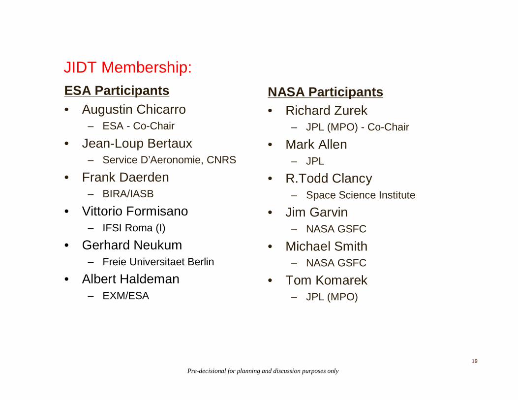
ESA-NASA discussions on Joint 2016 Mission (2009)Joint Instrument Definition Team (JIDT) studies Trace Gas instruments for
ExoMars orbiter/carrier; re-affirms need for both detection of broad suite of gases in atmosphere and mapping of key trace gases⇒ Earth-based observations confirm methane detection, report variability⇒ ExoMars slips to 2018 opportunityStudy of joint mission combining Trace Gas orbiter with technology drop-off
package is initiated (August, 2009)
Background (2 of 2)
Pre-decisional for planning and discussion purposes only
Agenda
• Science Rationale & Objectives for a Trace Gas Mission
• A Mission Concept (NASA only) to Achieve those Objectives
Pre-decisional for planning and discussion purposes only
5
What Science Questions are Raised by Methane Detection?
Current photochemical models cannot explain the presence of methane in the atmosphere of Mars and its reported rapid variations in space and time. Neither appearance nor disappearance can be explained, raising the following scientific questions:
• Is there ongoing subsurface activity?– Are there Surface/near-Surface Gas Reservoirs (particularly ice)? Where are they?
• What is the nature of gas origin: geochemical or biochemical?– Are other trace gases present? What are the isotopic ratios?
– Nature of the methane source requires measurements of a suite of trace gases in order to characterize potential biochemical and geochemical processes at work
• What processes control the lifetimes of atmospheric gases?
– Time scales of emplacement or activation and modification (seasonal, annual, episodic, longer term)
– Role of heterogeneous chemistry: reactions on surface or airborne dust and ice
– Atmospheric-surface exchange and atmospheric transport
⇒What is the inventory, transport, and photochemistr y of the Marsatmosphere? Note: It’s not just about methane!
Pre-decisional for planning and discussion purposes only
A Trace Gas Mission must provide:
• A comprehensive survey of both known gases (H2O, H2O2, CO, etc.), as well as to improve detection limits by an order of magnitude or more on gases not yet observed.
• A definitive statement about whether or not methane is still present in the atmosphere and characterize whatever variability it has. However, a detailed inventory of atmospheric gases and their isotopologues would be a major advance in our understanding of the recent history and climate of Mars whether or not methane is detected.
• Characterization of the roles that aerosols and temperature play in controlling atmospheric composition.
• All atmospheric fields required (temperature, density/pressure, wind, aerosol concentration) to enhance our ability to understand and to simulate for science and engineering the Mars atmosphere.
Pre-decisional for planning and discussion purposes only
Atmospheric CompositionAtmospheric evidence for present habitability
Key measurement objectives:Photochemistry (H2O2, O3, CO, H2O)Transport (CO, H2O)Isotopic Fractionation (isotopomers of H2O and CO2)Surface exchange (CH4 and H2O)Inventory (HO2, NO2, N2O, C2H2, C2H4, C2H6, H2CO, HCN, H2S,
OCS, SO2, HCl)
Measurement goals:Solar occultations to obtain sensitivity of 1–10 parts per trillionLimb-geometry mapping at sensitivity of 1–10 parts per billion with
latitude/longitude/altitude/local time coverage
⇒Would significantly improve knowledge of atmospheric composition and chemistry
⇒ Could lead to identification of source regions
Pre-decisional for planning and discussion purposes only
Atmospheric StateClimate processes responsible for seasonal / interannual change
Key measurement objectives:Wind velocityWater vapor and atmospheric temperature without influence of dustDiurnal coverage of all parametersVertical profiles of all parametersContinue climatology monitoring
Measurement goals:2-D wind velocity, temperature, aerosol optical depth, water vapor at
5 km vertical resolution over broad height rangediurnal coverage twice per martian season85% or better coverage along orbit
⇒ Extend record of climatology to characterize long-term trends⇒ Validate and significantly improve models of transport and state
Pre-decisional for planning and discussion purposes only
Surface Change ScienceRecent processes of surface-atmosphere interaction
Key measurement objectives:Geologic context of potential localized trace gas sourcesAeolian features (dust devil tracks, streaks, dust storm changes)Gullies, avalanches, dune motionsFormation of small impact craters over time
Measurement goals:1 meter resolution sufficient for these goals
⇒ Understanding active processes and the role of volatiles ⇒ Exchange of volatiles between high latitudes and atmosphere
Pre-decisional for planning and discussion purposes only
10
Detection:• Would require very high sensitivity to the following molecules and their isotopomers:
• Detection sensitivities of 1-10 parts per trillion
Characterization:• Spatial and Temporal Variability: Latitude-longitude coverage multiple times in a Mars
year to determine regional sources and seasonal variations (reported to be large, but still controversial with present understanding of Mars gas-phase photochemistry)
• Correlation of concentration observations with environmental parameters of temperature, dust and ice aerosols (potential sites for heterogeneous chemistry)
Localization:• Mapping of multiple tracers (e.g., aerosols, water vapor, CO, CH4) with different
photochemical lifetimes and correlations would help constrain model simulations and points to source/sink regions
• To achieve the spatial resolution required to localize sources might require tracing molecules at the ~1 part per billion concentration
• Inverse modeling to link observed concentration patterns to regional transformations (e.g., in dusty air) and to localized sources would require simulations using circulation models constrained by dust and temperature observations
Trace Gas Measurement Objectives
Pre-decisional for planning and discussion purposes only
Pre-decisional for planning and discussion purposes only
Sample “strawman” Payload (existence proof)
• Solar occultation spectrometer(s)Atmospheric composition (broad spectral range and high resolution)Mapping key species (narrower spectral range)
• Sub-millimeter spectrometerWind velocity through Doppler shiftWater vapor, temperatures, etc., without influence from dustMap key species
• Wide-angle camera (MARCI-like)Daily global view of surface and atmospheric dust and clouds
• Thermal-IR spectrometerDaily global observations of temperature, dust, ice, water vaporDirect comparison to previous climatology record
• High-resolution camera (as resources permit)*Imaging of possible local sources and active surface processes*Prime difference between TGM concept and earlier MSO
Pre-decisional for planning and discussion purposes only
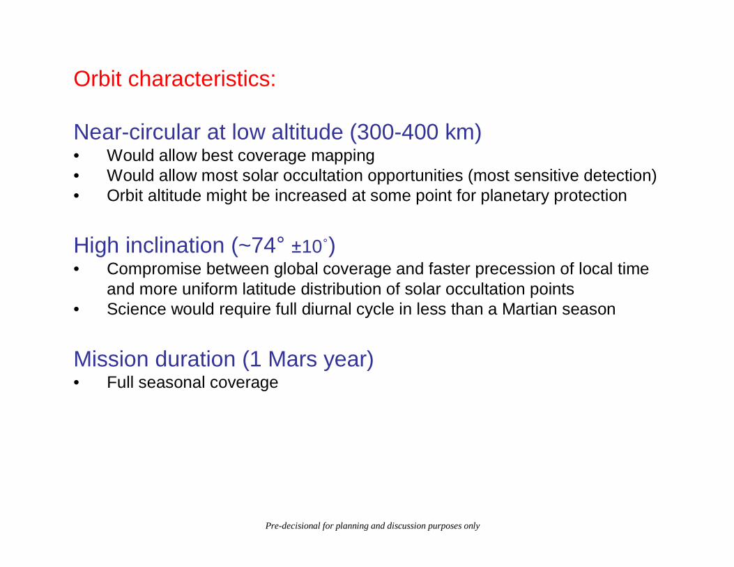
Orbit characteristics:
Near-circular at low altitude (300-400 km)• Would allow best coverage mapping• Would allow most solar occultation opportunities (most sensitive detection)• Orbit altitude might be increased at some point for planetary protection
High inclination (~74° ±10˚)• Compromise between global coverage and faster precession of local time
and more uniform latitude distribution of solar occultation points• Science would require full diurnal cycle in less than a Martian season
Mission duration (1 Mars year)• Full seasonal coverage
Pre-decisional for planning and discussion purposes only
Orbit tracks for one dayGood global mapping
Solar occultations for one yearGood latitude distribution
0 100 200 300 400 500 600 700
-80
-60
-40
-20
0
20
40
60
80
Time from Phase Start, day
Tan
ge
ntia
l La
titu
de
, de
g
Tangential Latitude at h = 0 km vs Time from Phase Start400 x 400 km, inc = 74 °, (not Sun-Sync)
1 Martian Year - Filtered Data
-150 -100 -50 0 50 100 150
-80
-60
-40
-20
0
20
40
60
80
Longitude, deg
Lat
itu
de,
deg
Latitude vs. Longitude400 x 400 km, inc = 74 °, 1 Earth Day
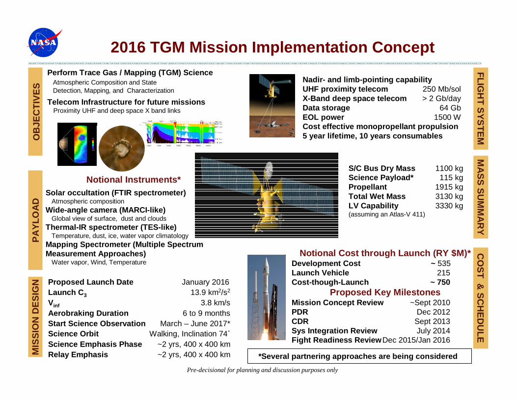
Nadir- and limb-pointing capability UHF proximity telecom 250 Mb/sol X-Band deep space telecom > 2 Gb/day Data storage 64 Gb EOL power 1500 W Cost effective monopropellant propulsion 5 year lifetime, 10 years consumables
FL
IGH
T S
YS
TE
MM
ISS
ION
DE
SIG
N Proposed Launch Date January 2016Launch C3 13.9 km2/s2
Vinf 3.8 km/sAerobraking Duration 6 to 9 monthsStart Science Observation March – June 2017*Science Orbit Walking, Inclination 74˚Science Emphasis Phase ~2 yrs, 400 x 400 kmRelay Emphasis ~2 yrs, 400 x 400 km
MA
SS
SU
MM
AR
YO
BJE
CT
IVE
S
Perform Trace Gas / Mapping (TGM) Science Atmospheric Composition and StateDetection, Mapping, and Characterization
Telecom Infrastructure for future missionsProximity UHF and deep space X band links
S/C Bus Dry Mass 1100 kg Science Payload* 115 kg Propellant 1915 kg Total Wet Mass 3130 kg LV Capability 3330 kg (assuming an Atlas-V 411)
Pre-decisional for planning and discussion purposes only
Proposed Key MilestonesMission Concept Review ~Sept 2010PDR Dec 2012CDR Sept 2013Sys Integration Review July 2014Fight Readiness ReviewDec 2015/Jan 2016
CO
ST
& S
CH
ED
UL
E
*Several partnering approaches are being considered
Summary:
• TGM would enable significant new science and provide key infrastructure elements
• TGM science objectives not covered by any other proposed mission (including MSR)
• 2016 is favored launch opportunity for TGM:� Would provide needed telecom support for other future missions� Would minimize gap in atmospheric monitoring� Possible synergy with proposed MAVEN extended mission
Pre-decisional for planning and discussion purposes only
Back-Up
Pre-decisional for planning and discussion purposes only
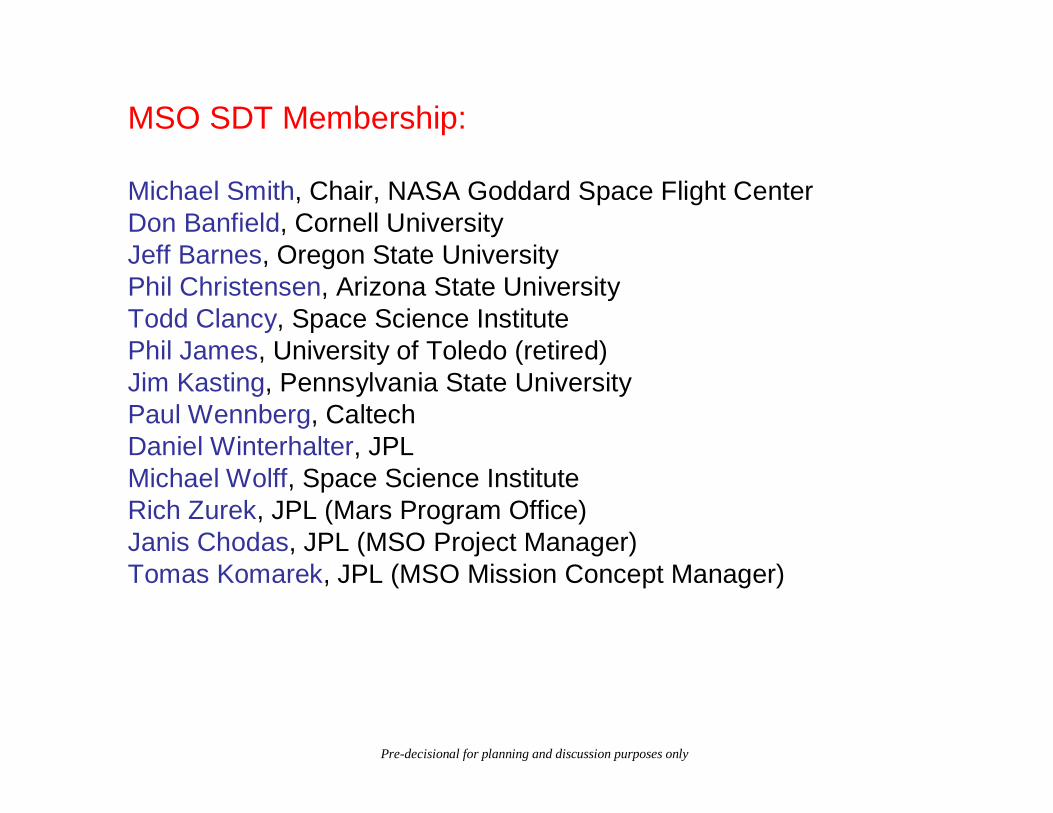
MSO SDT Membership:
Michael Smith, Chair, NASA Goddard Space Flight CenterDon Banfield, Cornell UniversityJeff Barnes, Oregon State UniversityPhil Christensen, Arizona State UniversityTodd Clancy, Space Science InstitutePhil James, University of Toledo (retired)Jim Kasting, Pennsylvania State UniversityPaul Wennberg, CaltechDaniel Winterhalter, JPLMichael Wolff, Space Science InstituteRich Zurek, JPL (Mars Program Office)Janis Chodas, JPL (MSO Project Manager)Tomas Komarek, JPL (MSO Mission Concept Manager)
Pre-decisional for planning and discussion purposes only


![A Feasible, Near-Term Approach to Human Stasis for Long ...Mars [2], and to far-term settlement-class missions to Mars [3]. 2 Background 2.1 Rationale and Goal designed for survival](https://static.documents.pub/doc/80x56/5f0881f67e708231d4225ae0/a-feasible-near-term-approach-to-human-stasis-for-long-mars-2-and-to-far-term.jpg)


