f'/1#35-34 MARYLAND HISTORICAL TRUST INVENTORY FORM FOR. STATE HISTORIC SITES SURVEY l[INAME HISTORIC AND/OR COMMON Boundary Stones ; '"DLOCATION STREET & NUMBER Western Ave., opposite Fessenden St. (Chevy Chase) to 16th St.,{Silver CITY.IOWN Cheyy Chase to Silver STATE Spring MaryJapd II CLASSIFICATION CATEGORY _DISTRICT -BUILOING(Sl _STRUCTURE }>WNERSHIP ll'PUBLIC _PRIVATE _BOTH - VICINITY OF ·, '.i STATUS -OCCUPIED -UNOCCUPIED -WORK IN PROGRESS SITE PUBLIC ACQUISITION _IN PROCESS ::LvEs: RESTRICTED _BEING CONSIDERED llJOWNER OF PROPERTY NAME Various STREET & NUMBER CITY.TOWN - YES: UNRESTRICTED _NQ _ VICINITY OF 0LOCATION OF LEGAL DESCRIPTION COURTHOUSE. CONGRESSIONAL DISTRICT Spring) COUNTY Montgomery PRESENT USE _AGRICULTURE _COMMERCIAL _MUSEUM _PARK -EDUCATIONAL _PRIVATE RESIQENCf _ENTERTAINMENT _RELIGIOUS _GOVERNMENT _INDUSTRIAL _MILITARY Telephone #: _SCJENTIFIC _TRANSPORTATION _OTHER: STATE , zip code Liber #: Folio #: REGISTRY OF DEEDS, ETC. Montgomery County Courthouse STREET & NUMBER CITY. TOWN Rockville STATE Maryland IJREPRESENTATION IN EXISTING SURVEYS TITLE DATE DEPOSITORY FOR SURVEY RECORDS CITY.TOWN _FEDERAL -STATE _COUNTY -LOCAL STATE
Transcript
f'/1#35-34
MARYLAND HISTORICAL TRUST
INVENTORY FORM FOR. STATE HISTORIC SITES SURVEY
l[INAME HISTORIC
AND/OR COMMON
D.C~/Md. Boundary Stones
; '"DLOCATION STREET & NUMBER
Western Ave., opposite Fessenden St. (Chevy Chase) to 16th St.,{Silver CITY.IOWN
Cheyy Chase to Silver STATE Spring
MaryJapd
II CLASSIFICATION
CATEGORY
_DISTRICT
-BUILOING(Sl
_STRUCTURE
}>WNERSHIP
ll'PUBLIC
_PRIVATE
_BOTH
- VICINITY OF
·,
'.i
STATUS
-OCCUPIED
-UNOCCUPIED
-WORK IN PROGRESS
SITE
~OBJECT PUBLIC ACQUISITION
_IN PROCESS
~CCESSIBLE
::LvEs: RESTRICTED
_BEING CONSIDERED
llJOWNER OF PROPERTY NAME
Various STREET & NUMBER
CITY.TOWN
- YES: UNRESTRICTED
_NQ
_ VICINITY OF
0LOCATION OF LEGAL DESCRIPTION COURTHOUSE.
CONGRESSIONAL DISTRICT Spring)
COUNTY
Montgomery
PRESENT USE
_AGRICULTURE
_COMMERCIAL
_MUSEUM
_PARK
-EDUCATIONAL _PRIVATE RESIQENCf
_ENTERTAINMENT _RELIGIOUS
_GOVERNMENT
_INDUSTRIAL
_MILITARY
Telephone #:
_SCJENTIFIC
_TRANSPORTATION
_OTHER:
STATE , zip code
Liber #: Folio #:
REGISTRY OF DEEDS, ETC. Montgomery County Courthouse STREET & NUMBER
CITY. TOWN
Rockville STATE
Maryland
IJREPRESENTATION IN EXISTING SURVEYS TITLE
DATE
DEPOSITORY FOR SURVEY RECORDS
CITY.TOWN
_FEDERAL -STATE _COUNTY -LOCAL
STATE
. fJ DESCRIPTION
CONDITION
-EXCELLENT _DETERIORATED
-GOOD _RUINS
_FAIR _UNEXPOSED
CHECK ONE
_UNALTERED
-ALTERED
LECK ONE
_ORIGINAL SITE
_MOVED DAT"'---~
DESCRIBE THE PRESENT AND ORIGINAL (IF KNOWN) PHYSICAL APPEARANCE
These are a series of 40 stone boundary markers erected to mark the D.C./Md. Line. Mqst are now encased in a steel protective cage. They are rough-hewn, rectangular-shaped stones with geographical inscriptions carved into them. The Mont._ Co. markers run along the dividing line from Western Bethesda to near the Prince George's Co. Line in Takoma Park.
CONTINUE ON SEPARATE SHEET IF NECESSARY
B SIGNIFICANCE
J?,.ERIOD AREAS OF SIGNIFICANCE -- CHECK AND JUSTIFY BELOW
These markers pre-date the Nation's Capital itself, as they were erected at the time of the Federal City survey in 1791-92. The survey and marking was conducted by Andrew Ellicott and Benjamin Banneker (a free Negro-who also completed L'Enfant's plans for the layout of Washington, D.C.)
CONTINUE ON SEPARATE SHEET IF NECESSARY
IJMAJOR BIBLIOGRAPHICAL REFERENCES Nye, Edwin Darby. "Revisiting Washington's Forty Boundary Stones, 1972", RECORDS OF THE COLUMBIA HIST. SOC.,. (1971-72).
CONTINUE ON SE~AR,ATE SHEET I~ NECESSARY
IIIJGEOGRAPHICALDATA ACREAGE OF NOMINATED PROPERTY--------
•• <
VERBAL BOUNDARY DESCRIPTION
LIST ALL STATES AND COUNTIES FOR PROPERTIES OVERLAPPING STATE OR COUNTY BOUNDARIES
STATE COUNTY
STATE COUNTY
D]FORM PREPARED BY NAME/TITLE
Michael F. Dwyer, Senior Park Historian ORGANIZATION
M-NCPPC STREET & NUMBER
8787 Georgia Ave. CITY OR TOWN
Silver Spring
DATE
6/10/74 TELEPHONE
589-1480 STATE
Maryland
The Maryland Historic Sites Inventory was officially created by an Act of the Maryland Legislature, to be found in the Annotated Code of Maryland, Article 41, Section 181 KA, 1974 Supplement.
The Survey and Inventory are being prepared for information and record purposes only and do not constitute any infringement of individual property rights.
RETURN TO: Maryland Historical Trust The Shaw House, 21 State Circle Annapolis, Maryland 21401 (301) 267-1438
Ps- uoa
I
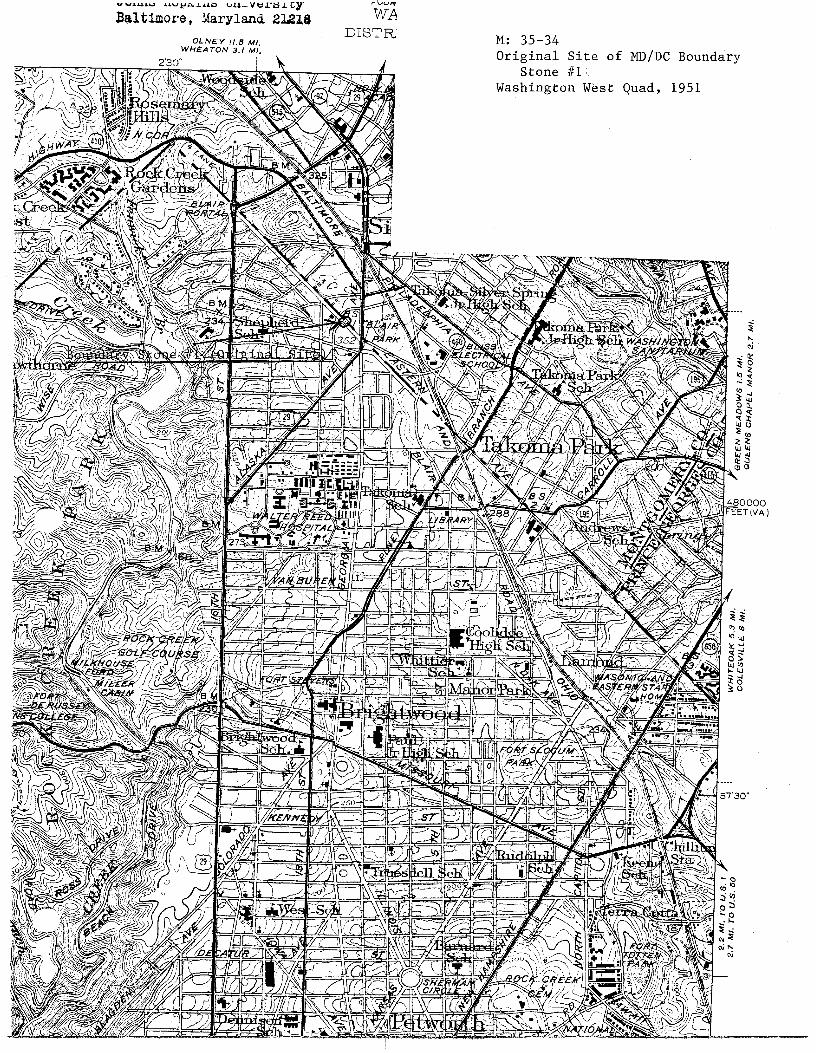
Federal Survey of 1791 M: 35-34 . Boundary Stones - DC and MD
The Federal Survey of 1791 of the newly designated Federal Capital Territory was commissioned by Secretary of State Thomas Jefferson in February 1791. The Survey, conducted by Major Andrew Ellicott with assistance from Benjamin Bannecker, was begun in February 1791 and completed in January 1793. When completed it represented the first official designation of the new F.ederal Capital and provided a basis for future city planning by Major Pierre Charles L' Enfant.
The original Federal Capital designation consisted of a forty mile square, encompassing land on both sides of the Potomac River in the States of Virginia and Maryland. Each side of the square was surveyed cuttin'g meridians at a 450 angle such that the square had north, east, south, and west corners, with northeast, southeast, southwest, and northwest sides. The south corner stone was laid first, at Jones' Point, Virginia, on February 12, 1791. From Jones' Point Ellicott laid out the ten-mile square in a clockwise direction. Lines were measured by means of a chain which was examined and corrected each day to ensure that the links had not opened and that there was no other change affecting accuracy. Sandstone markers were placed at every mile along each side, except where the miles terminated· in declivities or in water, in which case they were placed on the first firm ground and their true distances marked in miles and poles (see Figure 3). Each stone was inscribed with the words "Jurisdiction of the United States," "State of Maryland" or ~'State of Virginia," the year the stone was placed, and the conditions of the magnetic needle at that location (see Figure 3).
Andrew Ellicott was commissioned to complete the survey as one of the most well-known professional colonial surveyors. He possessed some of the finest surveying instruments in the United States at the time and had been involved in several important surveys, including location of Pennsylvania's western and northern boundaries and the first accurate measurement of the Niagara River (including the heights of the falls and the rapids). Subsequent to the Federal
Survey, Ellicott was involved with the determination of the boundary between lands of the United States and territories of France (1796 to 1800).
To assist in the survey, Ellicott enlisted Benjamin Bannecker to serve as his scientific assistant. Bannecker was perhaps the most famous Black man in colonial America, known as a scientist, inventor, and writer of one of the first series of almanacs printed in the United States. He was one of the first Black men to participate in public service to the new nation as a scientific assistant under the leadership of Major Pierre Charles L'Enfant.
Subsequent to completion of the ten-mile survey the team of Ellicott and Bannecker continued work on surveying locations of the Capitol, President's home, city parks, streets, and other public buildings in conjunction with work being performed by Major Pierre Charles L'Enfant. When L'Enfant resigned his position before the planned design of the Capital City was completed, Ellicott and Bannecker assumed responsibility for much of the remaining planning of the Capitol.
·~
~ I I I
' ~ I I I I I I
SOURCE:
I J M: 35- 34 Boundar y Stones - DC and MD
, • .j95
Figure 3:
LOCATION OF M!LE MARKERS
National Capital Planning Commission, "Boundary Markers of the Nation's Capital: A Proposal for their Preservation and Protection," U.S. Government Printing Office, Washington. O.C., Summer 1976.
£1..1..ICOTT CITY 2j FOUR CORNERS I M: 35-34 Stones #1, 2 , 9. MD/DC Boundary and
Stone, North Corner/MO County Stone, DC/PG County f #1
nd original site 01965 PR 1980 a t Quad, ' Washington Wes