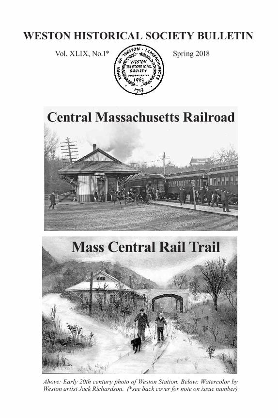
WESTON HISTORICAL SOCIETY BULLETIN Vol. XLIX, No.1* Spring 2018 Mass Central Rail Trail Above: Early 20th century photo of Weston Station. Below: Watercolor by Weston artist Jack Richardson. (*see back cover for note on issue number) Central Massachusetts Railroad
Transcript
WESTON HISTORICAL SOCIETY BULLETIN Vol. XLIX, No.1* Spring 2018
Mass Central Rail Trail
Above: Early 20th century photo of Weston Station. Below: Watercolor by Weston artist Jack Richardson. (*see back cover for note on issue number)
Central Massachusetts Railroad
Table of Contents
Introduction by Pamela W. Fox . . . . . . . . . . . . . . . . . . . . . . . . . . . . . . . . 3Timeline . . . . . . . . . . . . . . . . . . . . . . . . . . . . . . . . . . . . . . . . . . . . . . . . . . . 5Tales from the Central Mass.: Excerpts from the writings of Brenton H. Dickson III . . . . . . . . . . . . 7Weston Station by Pamela W. Fox . . . . . . . . . . . . . . . . . . . . . . . . . . . . . 131997: Weston Derails the Rail Trail by Pamela W. Fox . . . . . . . . . . . . 17Rail Trail Back on Track by Pamela W. Fox and Paul Penfield Jr. . . . . 27What’s Next? by Paul Penfield Jr. . . . . . . . . . . . . . . . . . . . . . . . . . . . . ..28
Field Guide to the Treasures of the Trail by Paul Penfield Jr., Phyllis Halpern, and R. Richard Conard
Paul Penfield Jr. (center, with hat), member of the Weston Rail Trail Advisory Com-mittee, leads a walk on the future rail trail on October 30, 2017. The walk was co-sponsored by the Weston Garden Club, which maintains the Forbes Conservation Land located immediately off the trail just east of Weston Station. (Photo by Pamela W. Fox)
3
IntroductionThe railroad that came to be known as the Central Massachusetts was chartered in 1868 at the peak of railroad fever. Every town wanted to be on a rail line. The Central Mass. has been described as “a railroad that should never have been built” and “an anachronism before the first spadeful of earth was turned.” (1)
The original officers had no practical experience either in building or operating railroads. As Col. Daniel S. Lamson wrote in his History of the Town of Weston: “they went to work blindly, and began their road ‘nowhere,’ and ended it in about the same place, as regards being within the reach of business.” (2)
One problem with the Central Massachusetts was that it was never more than 20 miles from two financially successful and well-established lines: the Fitchburg to the north and Boston & Albany to the south. The big markets were already well served. Wayland, a town of only 1,766 people in 1875, was the largest community not on some other railroad line. (3) Other problems included inadequate funding and costly engineering decisions. The struggles and bankruptcies of this ill-starred venture have been chronicled in detail in two books: The Central Mass., published by the Boston & Maine Historical Society, Inc., and The Mass. Central: Quabbin’s Phantom Railroad by J.R. Greene. (4)
The Central Mass. carried its last passenger in 1971 and its last freight load in 1980. Since that time, as weeds flourished along the abandoned rail bed, proposals
Promoters of the ill-fated Central Mass. Railroad hoped to reach west of New England, but they were lucky to make it to Northampton. (Railway & Locomotive Historical Society)
4
to restore rail service or turn the right-of-way into a rail trail have come and gone. Finally, a more stable era may be at hand. Weston and Wayland can expect to see 4.5 miles of the new Mass Central Rail Trail open this year.
This issue of The Weston Historical Society Bulletin is devoted to the Central Mass. Railroad and Mass Central Rail Trail. To understand what it was like to commute by train to Boston in the early 20th century, we have reprinted the colorful anec-dotes of Weston historian and masterful storyteller Brenton H. Dickson III. The defeat of the rail trail proposal at Weston Town Meeting in 1997 is addressed here, along with current plans.
The second half is devoted to the “Treasures of the Trail” — from Weston Station and the trestle bridge to cattle passes and “tell-tales.” Written largely by Rail Trail Advisory Committee member Paul Penfield Jr., a retired M.I.T. engineering pro-fessor, this detailed guide reflects not only his interest in history and understand-ing of how things work, but also his enthusiasm in conveying that knowledge to rail trail users now and in the future. The editor would also like to thank Paul’s co-authors, Weston Historical Commission co-chair Phyllis Halpern and railroad historian and Wayland Historical Commission member R. Richard “Rick” Conard for their help com piling the “Treasures of the Trail.”
Pamela W. Fox, Editor
(1) The Central Mass., published by the Boston & Maine Railroad Historical Soci-ety, Inc., 1975, expanded and reprinted 2008, vii; (2) Daniel S. Lamson, History of the Town of Weston, Massachusetts, 1630–1980 (1913), 146–147; (3) The Central Mass., op cit.; (4) The Central Mass. (see footnote 1) is available at Wayland Depot gift shop. The Mass. Central: Quabbin’s Phantom Railroad by J. R. Greene was printed by Athol Press, Athol, MA (1996).
This is the only known photo of a train with the name of the origi-nal company: “Massa-chusetts Central.” It was probably taken in the fall of 1881. Two years later, the line was reorganized and renamed the Central Massachusetts. (Hud-son Historical Society)
5
Timeline1868 Massachusetts legislature grants petition creating the Wayland & Sudbury Branch Railroad, to run from Mill Village in Sudbury to Stony Brook in Weston, on the Fitchburg line, a distance of 6.75 miles.
1869 Massachusetts legislature grants petition creating the Massachusetts Central Railroad, with the right to unite with the Wayland & Sudbury Branch to construct a railroad from Stony Brook to Northampton, about 98 miles.
1870 The fledgling railroad sells stock to raise funds. Because Weston had the Fitchburg Railroad, with four stops, and the Boston and Albany running through the south edge of town, Weston was less enthusiastic than Wayland and twice rejected resolutions to purchase stock from town funds.
1871 A contract is signed in April 1871 and construction begins.
1873 The original contractor is forced into bankruptcy All work ceases.
1878 Efforts begin to revive the railroad. A new bond issue is authorized.
1880 The Boston & Lowell Railroad agrees to lease and operate the rail line when completed, for a term of 25 years. Construction begins again.
October 1, 1881 The rail line opens for business from Boston to Hudson (28 miles). Weston Station is in place. Con struction continues 20 more miles to Jefferson, a hamlet in the town of Holden.
May 1883 Operations cease due to financial problems. No trains for 29 months.
November 1883 The Massachusetts Central Railroad is reorganized and renamed the Central Massachusetts.
September 28, 1885 Trains begin running again.
1886 – 87 The Central Mass. is leased to the Boston & Lowell. In turn, the B & L is leased to the Boston & Maine for 99 years. Since then, the Central Mass. has been an integral part of the Boston & Maine. Construction to the west is resumed and reaches Ware, then Northampton.
December 19, 1887 First train for Boston departs from Northampton.
1896 – 1903 Construction of the Wachusett Reservoir requires relocation of seven miles of Central Mass. track.
1907 – 1914 Peak of operations. Later, World War 1 also generates traffic.
1927 – 1930s Automobiles, trucks, and the Great Depression bring retrenchment.
6
1932 Last through passenger train travels from Boston to Northampton.
1938 Damage from Hurricane of 1938 physically severs the rail line at Coldbrook (near Barre), and the two ends are never rejoined.
1940s Train service revives during World War II, with four trains daily between Clinton and Boston and more serving a large ammunition depot in Stow and Maynard. Service decreases after the war.
Late 1950s – 1969 Service cutbacks reduce weekday number of round trips to two a day, then one. In 1968, passenger counts average 77 riders per day.
March 1970 Boston & Maine goes into bankruptcy.
1971 “Save the train” campaign in October and November is unsuccessful. Last passenger train runs on November 26, ending 90 years of passenger service.
1980 Last freight train.
1990s Plans develop for construction of a 25-mile “Wayside Rail Trail” from Belmont to Hudson (see pages 17 - 27).
December 8, 1997 Weston Town Meeting votes against entering into lease to build the rail trail through Weston (see pages 17 - 27).
December 30, 2010 Massachusetts Department of Conservation and Recreation (DCR) leases, from the Massachusetts Bay Transportation Authority (MBTA), 23 miles of the former Central Mass. rail corridor between Waltham and Berlin for the proposed rail trail.
January 10, 2014 DCR receives a waiver from the requirement to prepare an Environmental Impact Report, greatly simplifying permitting. 2016 MBTA agrees to let Eversource file for required conservation permits to build a gravel access road so its maintenance crews can safely access electrical transmission lines along the railroad right-of-way.
October 2016 Eversource files notices of intent to Wayland and Weston to construct a gravel access road.
January 2017 DCR joins Eversource in filing updated notices of intent that include the proposed multi-use rail trail.
April 2017 Wayland completes half-mile section of rail trail between the Wayland Station and Boston Post Road crossing.
October 11, 2017 Historic assets along the trail are marked for protection.
October 16, 2017 Construction of Eversource access road starts in Wayland with rail and tie removal, grading, and gravel spreading. Construction stops in December when the ground freezes. The work will resume in spring 2018.
7
Tales from the Central Mass. by Brenton H. Dickson III
Brenton H. Dickson III (1903 – 1988), a man of many talents, is perhaps best known for Once Upon a Pung (privately printed, 1963). This book of Weston history, told through amusing anecdotes in Dickson’s unique style, grew out of the town’s 250th anniversary celebration. In his “Special Acknowledgement,” Dickson writes: “A picture of an era can’t be drawn with facts alone; it must have appropriate anec-dotes to support it and to give it color.” In these excerpts from Once Upon a Pung and from a May 1980 article in The Weston Historical Society Bulletin, Dickson adds his special splashes of color to the history of the Central Mass.
The Fitchburg Railroad, which served Kendal Green, was an important line. Train after train rushed past the station with Pullmans and dining cars, some bound for Troy, New York, some for points in New Hampshire and Vermont, one or two for Montreal, and another for Chicago. As the commuter trains were part of an import-ant family, they couldn’t stoop to the informality of the Central Massachusetts branch, but maintained a certain air of dignity. Also, there was something forebod-ing about the long, straight stretches of double track. The line bore no resemblance to the curvaceous Central Massachusetts. (From Once Upon a Pung, 55–56) * * *
A “Save the Train” campaign in late 1971 attempted to increase rider-ship and keep commuter trains running. The effort was unsuccessful, and passenger service ended on November 26, 1971. (H. Bentley Crouch Collection)
8
Weston’s third railroad, the Central Massachusetts, in its early days was referred to as the “Boston to Nowhere.” It was my favorite and far and away the most informal of Weston’s three lines. Originally planned as a line connecting Boston with Northampton, it was beset with serious financial difficulties from the day it was born. Grading began in 1871 and after ten years of work and the expenditure of millions of dollars, less than fifty miles of track had been laid. After two more years, money problems became so acute that the bondholders foreclosed and service came to a stand-still. Over the next two years, trees grew in the neglected roadbed while erosion from melting snow and heavy rains played havoc with the grading.
Finally an agreement was made in 1885 with the Boston and Lowell to complete the line to Northampton. Service was first resumed to Hudson, and on September 28, 1885, my father made the following entry in his diary: “I went in on the 7:30 train from Cherry Brook. It was the first train on this railroad for more than two years. Mr. Merriam gave the conductor a watermelon and Jessie gave him some flowers.” Mr. Merriam owned a large farm at the junction of Merriam Street and Concord Road. Jessie was his daughter.
As far back as I can remember my father commuted on the Central Massachusetts daily. When I was first married I lived in Wayland and also used this line daily; then when I moved back to Weston I often walked down to Tower Hill Station from my house on Love Lane. As I walked I knew just where I had to be at certain times. I could hear the distant whistle of the train as it approached various grade crossings, and could gauge my position with each blowing.
It was a pleasant 18 minute walk in the early 1930s and mostly downhill. There was very little traffic on the Post Road and practically none on side roads — no
This timetable dates from 1881, before the railroad was reorganized and renamed. The building is the Boston & Lowell depot (Old North Station) on Causeway Street in Bos-ton. (H. Bentley Crouch Collection)
9
bumper to bumper stuff that characterizes the Post Road rush hours today. . . .
The Central Massachusetts was patronized by the same people day after day. If you forgot your ticket the conductor would let you bring it to him the following morning. The three morning trains left Weston at 7:03, 8:02 and 8:43 and were known respectively as the “Workers,” the “Clerkers,” and the “Shirkers.”
There were several unforgettable characters on the 8:02 o’clock train, one of them being my Uncle Ned Bennett, who commuted from Tower Hill. Once aboard the train he would walk from one seat to another to converse with his various friends. One morning the conductor was heard to remark: “I don’t charge Mr. Bennett any fare. He walks all the way to Boston.”
On holiday eves decorations appropriate to the season were attached to the cow-catcher — lilacs in the springtime, goldenrod in the autumn, a pumpkin on Hal-loween and evergreen boughs at Christmas.
The earliest conductor I can remember was Mr. Wheelock. He lived in Lancaster and had an incubator in his cellar where he raised chickens for us. On the appro-priate day he would bring the baby chicks in the baggage car and deliver them to us at Weston Station.
One of the unforgettable early station agents was Bert Giles, a short wirey man who always seemed to be in a hurry. I never remember seeing him walk leisurely; he was more like a jogger. This could well be accounted for by his moonlighting during off hours to make extra money to fulfill his life’s great ambition — a trip to the Ober-amegau [sic] Passion Play in Southern Austria. When he had finally saved enough money he went. (From The Weston Historical Society Bulletin, May, 1980, 4–5). * * *
Railroad organizers had trouble raising money. Even in Weston, where the railroad would directly benefit the town, voters twice rejected resolutions to purchase shares of stock with public funds. (Hudson Historical Society)
10
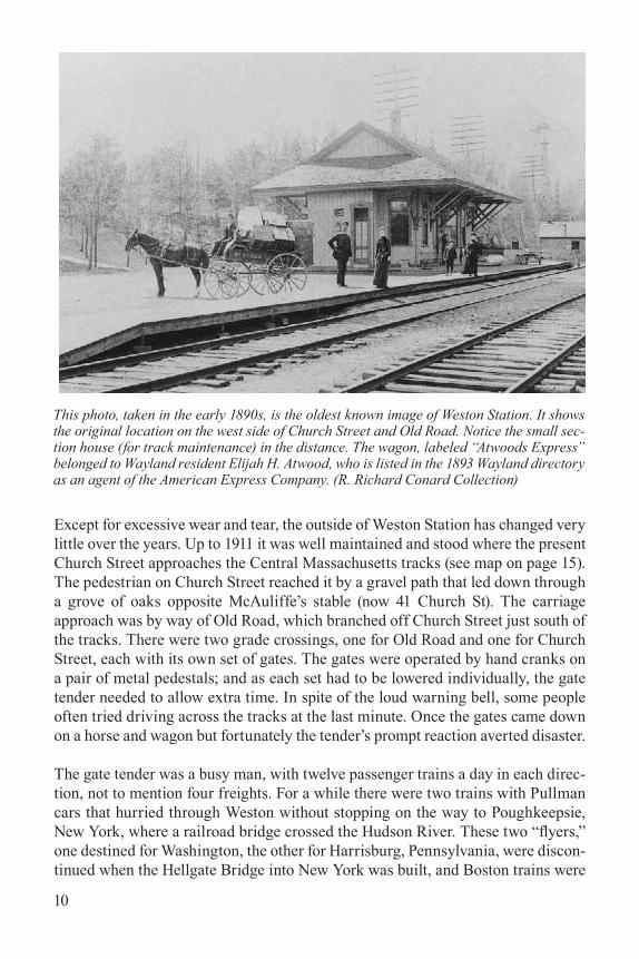
Except for excessive wear and tear, the outside of Weston Station has changed very little over the years. Up to 1911 it was well maintained and stood where the present Church Street approaches the Central Massachusetts tracks (see map on page 15).The pedestrian on Church Street reached it by a gravel path that led down through a grove of oaks opposite McAuliffe’s stable (now 41 Church St). The carriage approach was by way of Old Road, which branched off Church Street just south of the tracks. There were two grade crossings, one for Old Road and one for Church Street, each with its own set of gates. The gates were operated by hand cranks on a pair of metal pedestals; and as each set had to be lowered individually, the gate tender needed to allow extra time. In spite of the loud warning bell, some people often tried driving across the tracks at the last minute. Once the gates came down on a horse and wagon but fortunately the tender’s prompt reaction averted disaster.
The gate tender was a busy man, with twelve passenger trains a day in each direc-tion, not to mention four freights. For a while there were two trains with Pullman cars that hurried through Weston without stopping on the way to Poughkeepsie, New York, where a railroad bridge crossed the Hudson River. These two “flyers,” one destined for Washington, the other for Harrisburg, Pennsylvania, were discon-tinued when the Hellgate Bridge into New York was built, and Boston trains were
This photo, taken in the early 1890s, is the oldest known image of Weston Station. It shows the original location on the west side of Church Street and Old Road. Notice the small sec-tion house (for track maintenance) in the distance. The wagon, labeled “Atwoods Express” belonged to Wayland resident Elijah H. Atwood, who is listed in the 1893 Wayland directory as an agent of the American Express Company. (R. Richard Conard Collection)
11
routed more directly along the shoreline through Providence and New Haven.
The railroad siding at Weston was an important passing point on this single-track line. Dispatching was done by telegraph, and orders were taken down by the sta-tion agent to be handed to the engineer or conductor of an arriving train. At vaca-tion time the “Smith College Special” — a train of fifteen to twenty cars, came along the Central Massachusetts, stopping at any station where a pupil wanted to get off. The engineer could not always guess which car the pupil was in, so when-ever he overshot his mark, he’d agreeably back up to a point where the conductor considered it safe for the young lady to alight — a good way to run a railroad by winning friends and influencing people.
But this wasn’t the only train to overshoot its mark. Between Cambridge and Waltham, for a stretch of several miles, the Central Massachusetts and the Fitch-burg ran parallel to one another, and whenever there were two trains going in the same direction, it was customary for them to race. This was always a thrilling experience, with passengers and crew entering into the spirit of the event. A race was considered won when the brakeman, standing on the rear platform, lined up his position with the cowcatcher of the other train. On one occasion the race was neck and neck, and both trains roared through Belmont and Waverley a mile a minute. Beyond Waverley, the Fitchburg train began to lag somewhat and, as the two trains approached Clematis Brook, a scheduled stop for the Central Massa-chusetts, there was no lessening in speed. Our local Casey Jones must do or die! Victory was within his grasp. A quarter of a mile beyond Clematis Brook the Fitchburg train finally conceded and the victor stopped, backed up, and proudly discharged its passengers. . . .
For several years an outbound train arrived just ahead of the eight o’clock and trans-ferred its empty rear car to the inbound train at Weston to take care of the heavy traffic from Waltham and Belmont. Habitual card enthusiasts always boarded this particular car on its Weston arrival so that they might have a little extra time for their game. When the 8 o’clock train for Boston pulled into the station the out-bound train went up the track a few yards where the trainman threw the switch and uncoupled the back car. Then the engine would go into reverse for a puff or two and the car with its card players would coast down the track to be coupled onto the Boston-bound train.
There is a gentle but steady grade through Weston which is responsible for a story that can now be told, as none of those concerned are any longer in the employ of the Boston & Maine. One day the station attendant heard something coming down the track at a time when nothing was scheduled to pass. He looked out to see a lone freight car thundering by at 40 miles per hour. Apparently it had escaped from a train shunting cars onto Ogilvie’s siding beyond Cherry Brook.
A minute or so later, a locomotive came down the track and stopped at the station.
12
“Have you noticed a stray car?” the engineer asked.
“Yes,” replied the station attendant, “and boy was it traveling!”
Half a mile below Weston Station there is a low point in the tracks with an upgrade towards Waltham Highlands, and this is where the stray car came to rest. Having recovered it, the engineer stopped again at the station on his return trip.
“You didn’t see this car going down the track did you?” he asked.
“No, I didn’t see a thing,” said the attendant with a wink.
“Good!” said the engineer and he went away reassured. . . .
One of the more interesting Central Massachusetts passengers was “Prince,” a dog belonging to the station master. Although he spent much of the day lying on the plat-form, he occasionally would board a train for Waltham Highlands or Wayland, get off at the destination of his choice, and return to Weston on the next train. He knew the crews and the station agents and no doubt he was fed tidbits by all of them. . . .
Like Cutting’s store, Weston Station was a forum for discussing local events. Day after day the same commuters arrived for the same train, and any absences were noticed and had to be explained the next morning. Some commuters arrived in carriages, one or two, perhaps, in an automobile, and the rest on foot. The Central Avenue [now Boston Post Road] contingent cut through Mr. Horace Sears’ woods, where a well-maintained path saved them nearly half a mile of walking. This path was illuminated from dusk until the arrival of the midnight train. When the mid-night train passengers had had time to walk the length of the path, Mr. Sears’ butler turned off the lights, all of which illustrates the neighborhood spirit that prevailed. (From Once Upon a Pung, Chapter 11)
The job of agent/operator at train stations generally included sending telegrams; selling passenger tickets; keeping records of sales and cash; handling baggage, express, and mail; handling articles of freight; and receiv-ing and sending messages by telegraph, both railroad and Western Union (public) mes-sages. They maintained the station, stoked the coal stove in winter, and lowered cross-ing gates. This photo shows Weston Station agent Charles R. Cole and his dog Prince in 1909. (R. Richard Conard Collection)
13
Weston Station by Pamela W. Fox
Weston Station was in place by the grand opening of the Massachusetts Central Railroad on October 1, 1881. It is one of the last remaining original depots, the others being in Wayland, Waltham Highlands, Gilbertville, and Amherst. (1)
Stations were similar in style and have been described as “typical of the times and yet the architect . . . managed to instill in them certain characteristics which set them apart from other railroads and gave them a picturesque style on which it would have been difficult to improve.” (2) The architect has not been identified.
Architectural historians call this “Stick Style.” The station has the characteristic wide overhanging eaves, in this case a full six feet wide, to shelter passengers awaiting their train. Large decorative truss brackets support the eaves. For the exterior walls, the architect used board and batten, an economical and also decora-tive material with strong vertical lines. Originally, the boards and battens extended all the way to the ground, but in the mid-1940s, clapboard wainscoting was applied up to the bottom of the windows. (3) The diagonal boarding of the freight doors adds visual interest, as do the carvings in window and door lintels.
These elevations of Weston Station come from “Railroad Structures,” by Armitage, Plan Book No. 1, HO Scale, Plan Sheet R-6, published to help model train enthusiasts build reproduction depots and freighthouses. (Weston Historical Society)
14
Stations came in only two basic designs. The most important stations, includ-ing Weston, utilized a “gable on hip” roof, while subordinate stations had a con-ventional gable roof. Depots built after 1887 had a hip roof. The gable-hip types included some with built-in freighthouses, such as Weston, and others without this feature. Except for minor deviations in dimensions and ells, the depots had a “distinct commonality,” but modifications made each slightly different as well. The railroad had a policy of not putting similar stations next to each other on the line. (4)
Weston Station measures 18’ X 47.’ Inside was a ticket office, waiting area, tele-graph office in the center, and restrooms. Photos show the many telegraph wires extending along the tracks. In the late 19th and early 20th century, before tele-phones came into common use, residents would come to the station to send tele-graph messages.
Outside, on the trackside, a long wooden platform made it easier for passengers to step on and off the train cars. Commuters living north of the tracks could walk down the long steps from the Church Street overpass and get right onto the platform. The plat-form was replaced by asphalt in the mid-1940s. The freight platform needed to be higher to unload goods and materials from wagons.
Extending from the roof of the depot was the train order
semaphore signal, controlled from inside the telegraph bay through a system of levers and rods. The semaphore was high so the signal would be visible above the overpass.
In 1906, Weston voters passed a resolution to abolish the grade crossing on Church Street, a location that was particularly problematic because there were two cross-ings together, one at Old Road and the other at Church Street (see map, p.15). The 1908 Town Report includes the plan to relocate Church Street to the west and cross the tracks by way of a new concrete bridge. Old Road would be relocated to join Church Street just north of the tracks. The depot would be moved 215 feet to the east, while the freight spur track stayed in its original location. (5)
Plan of Weston Station from “Railroad Structures,” by Armitage, Plan Book No. 1, HO Scale, Plan Sheet R-6A. (Weston Historical Society)
15
This reinforced concrete bridge was constructed in 1911-12 to eliminate the grade crossing at Church Street. The station was relocated at that time. The smaller arch allowed wagons to pass between the relocated station and the freight spur track, which remained in its original location west of Church Street. The bridge on Concord Road was constructed at the same time. Petitions were made to eliminate grade crossings on the Fitchburg line but that work was never carried out. (Weston Historical Society postcard, c. 1912)
Detail from 1908 Atlas of Middlesex County showing the original location of Weston Sta-tion on the west side of Old Road (left fork) and Church Street. The two grade crossings each had gates that had to be lowered individually by hand.
16
In a March 1910 letter reporting on the status of the plan, Charles H. Fiske Jr. writes that the Boston & Maine Railroad initially opposed the concrete bridge and “wanted to have wooden bridges and stone abutments if any bridges were built at all.” Fiske added: “The [Railroad] Commission has decided in form of [sic] con-crete bridges, as we recommended, and insisted upon. The Town . . . is to pay 10% of the cost, the Railroad 65%, and the Commonwealth 25%.” (6) Work began in 1910, and the bridge was constructed in 1911-12 with a large arched opening for the train tracks and a smaller arch that allowed freight wagons to travel between the freight spur track and re-located station. The Concord Road bridge was con-structed at the same time, with both completed by the summer of 1912.
In the 1911 Town Report, Fiske gives a full history of the planning and construc-tion and concludes with this remark:
It is regrettable that the railroad does not see its way clear to building a new station at Weston. . . . The railroad promises to renovate the present station to some extent. It is hoped a new station more in keeping with its surroundings will be provided.” (7)
Footnotes
(1) The Central Mass., The Boston Maine Railroad Historical Society, 1975 and 2008, 87–90; (2) Ibid., 87; (3) “Railroad Structures,” by Armitage, Plan Book No. 1, HO Scale, Plan Sheet R-6A (Weston Historical Society); (4) The Central Mass., op. cit., 87–88; (5) Other possibilities are explored in the 1908 Town Report, 27–34, which includes a site plan; (6) 1909 Town Report, 24; (7) 1911 Town Report, 35–37.
Boston & Maine Engine 3235 on west-bound passenger train at Weston Station, c. 1950. Note the two men on the caboose at far left. (Photo by Wayne Brumbaugh, from Bos-ton & Maine Historical Society flickr website)
17
1997: Weston Derails the Rail Trail
by Pamela W. Fox
Two decades ago, efforts to create a “Wayside Rail Trail” were effectively aban-doned, in part because of Weston opposition.
This chapter of the Central Mass story began with the Intermodal Surface Trans-portation Efficiency Act (ISTEA) of 1991, which required transportation plans for all U.S. metropolitan areas, with bicycle-pedestrian components. A bicycle-pe-destrian steering committee was formed by the MetroWest Growth Management Committee, with one or more members from each community. The group, which included Weston representative Ken Hablow, met from 1992 through August 1996, providing local input to the “Metro West Bicycle Pedestrian Study,” published in 1997. (1)
This review of overall needs and opportunities in Weston and neighboring com-munities for non-motorized transportation alternatives led to the 1997 “Central Massachusetts Rail Trail Feasibility Study,” which concluded that a trail (later renamed the Wayside Rail Trail) was feasible. At the time, the right-of-way was owned by the Massachusetts Bay Transportation Authority (MBTA). (2)
This cartoon by Dave Granlund appeared in the December 7 issue of Middlesex News, one day before Weston Town Meet-ing voters rejected the proposed Way-side Rail Trail. At that time five of the seven communities on the trail had approved it. (John A. Fiske file)
18
The Wayside Rail Trail
The proposed Wayside Rail Trail was to extend 25 miles through seven towns, from Belmont through Waltham, Weston, Wayland, Sudbury, Hudson, and Berlin. (3) Of the 25 miles, 3.1 miles are in Weston. Design and construction costs, to be paid for with state and federal funds, were estimated at from $6 to $11 million dollars. (4) Municipalities would maintain and patrol the trail within town borders once it was built. (5)
In the late 1990s there were 885 rail trails in the US, 10 of which were in Massa-chusetts, including the Minuteman Bikeway from Arlington to Bedford, the Cape Cod Rail Trail, and the Norwottuck Rail Trail from Amherst to Northampton.
The Wayside Rail Trail Committee (WRTC), made up of citizens from all seven towns on the proposed route, was founded as a non-profit citizens’ group working to get the trail built. When completed, the organization promised to assist in main-taining and improving the trail and educating the public about its safe use and enjoy-ment. Weston representatives on the WRTC were Kate Detwiler and Ken Hablow.
Weston Studies the Rail Trail
In the spring of 1997, five of the seven towns (excepting Belmont and Weston) voted to join the trail, all by large margins. In Wayland, the vote was 150 for and 1 against, with little debate required in an otherwise contentious Town Meeting. (6)
At the May 1997 Town Meeting, Weston residents voted 228 to 121 to support a study of the trail. (7) A Rail Trail Task Force (RTTF) was appointed to do the study, co-chaired by Kate Detwiler, Weston Chair of the Wayside Rail Trail Committee and member of the Weston Planning Board, and Doug Gillespie, member of the Environ-mentally Concerned Outdoorsmen and Chair of the Weston Public Works Commit-tee. Joe Mullin, Chair of the Weston Board of Selectmen, was the BOS liaison.
Thirty-four people signed in at the first general meeting on June 16, 1997. The committee included representatives from various town boards, departments, and committees along with representatives designated by each abutting neighbor-hood: Carroll Circle, Church Street, Conant Road, Concord Road, and Gun Club Lane. Additional interested parties were welcomed as participants. According to the minutes, the committee determined from the onset that “voting on any RTTF general meeting issue will be open to all persons who have attended a majority of RTTF general meetings, with the same rule applying to subcommittee votes.” (8)
19
Nine subcommittees were formed: Parking and Traffic; Restrooms and Amenities (later consolidated with Traffic and Parking); Concerns of Abutters; Trail Surface and Environmental Issues; Town Center Impacts; Maintenance, Costs and Reve-nues; Public Safety Issues; Equestrian Issues; and Utilization/Statistical Data. The six-month schedule called for recommendations to be presented to the Board of Selectmen by November 19, 1997.
Disagreements were quickly apparent. An undated letter addressed “Dear Rail Trail Supporter” and signed by Weston residents David R. Conna and Mary Horne summarized the viewpoint of supporters involved in the process:
Originally it was envisioned that the task force would identify and address legitimate concerns related to the construction of the trail. To be sure, some important issues are being discussed and addressed. However, very early on in the process, it became clear that the task force was made up primarily of rail trail opponents who are more interested in using those issues, whether legitimate or not, to further their agenda of opposition to a trail. Unfortu-nately, objective evaluation of the data often does not occur. (9)
Trail Opponents Suggest Mitigation Measures
Two groups spearheading opposition were equestrians and abutters. Equestrians were concerned because they used the rail corridor to access trails in the Jericho Town Forest and Wayland and to reach the Dickson Riding Ring. The Equestrian Issues Subcommittee identified seven trail crossings along the right of way where
Kate Detwiler and Doug Gillespie co-chaired the Rail Trail Task Force, which stud-ied the impact of the proposed trail on Weston. (Detwiler photo from Weston Town Crier, May 29, 2003. Gillespie photo from 1998 Weston Town Report)
20
safe crossings would be essential.
The Equestrian Issues subcommittee agreed on a requirement that a parallel bridle path from behind Ogilvie’s to Wayland be constructed outside the rail corridor on land obtained by negotiating with abutters, with the goal of preserving exist-ing trail loops and allowing Weston riders to continue to access Wayland trails. Opponents objected that the proposed trail easements passed through wetlands and included areas not used by horseback riders, concluding “not only would this be expensive, it is in all likelihood not possible.” (10) At their August 24 meeting, the subcommittee decided by unanimous vote that their preferred option was not to have a rail trail at all but rather to leave the existing roadbed in place. (11)
The Concerns of Abutters subcommittee developed a survey that, according to rail trail supporters, did not objectively solicit opinions but rather focused on negative fears and concerns. The subcommittee proposed monetary concessions from the town as mitigation for potential real estate losses. Proponents described this con-dition as one that “the town was very unlikely to agree to.” (12)
Lead up to Special Town Meeting
A special Town Meeting was called for December 8, 1997. In November, the Rail Trail Task Force voted 27 to 15 not to support the trail. Among the areas of concern were public parking and traffic, restroom facilities, environmental impact of design and construction, impact on abutting town conservation land, public safety and concerns of abutters, impact on town center, and cost to the town. The RTTF pub-lished a “Final Report and Recommendations,” presented to the Board of Select-men on November 21, 1997. The summary explains the committee’s position:
Through six months of extensive research by many great citizens, the RTTF has developed a series of mitigation measures which help to reduce negative impacts of the trail. However, the RTTF has been unable to adequately miti-gate several serious impacts, thus making the trail unacceptable.
Included in the impacts which could not be mitigated are: financial impacts upon the town through direct cost increases for town services . . . which could exceed $162,000 annually; further financial impacts likely to result from sig-nificant tax abatements to abutting property owners, and legal fees defend-ing the town from court actions brought by abutters seeking recovery of lost property equity resulting from the town’s participation; decreases in “quality of life” issues resulting from the trail, and existing easements, in several neighborhoods . . . [10 neighborhoods cited]; and detrimental environmental
21
impacts . . . upon abutting conservation lands owned by the town.
Thus, it is the primary recommendation of the RTTF that Weston not partici-pate further. . . Since full mitigation is impossible, and the unmitigated areas are still substantial, it is not in Weston’s best interests to develop the rail corridor through the town. (13)
The report included secondary recommendations, in the event that Town Meeting voted to support the trail.
The RTTF voted not to include a report from the minority. Trail supporters obtained funding from the Board of Selectmen; and a group calling itself “Weston Resi-dents for the Wayside Rail Trail” prepared “The Rail Trail Alternative Report” (November 1997), a hefty document addressing concerns and including studies of trails across the county. The minority report argued that the positives outweighed the negatives, the trail would be a regional recreational asset, and that by voting “yes,” residents could keep better control over the process. They expressed con-cern that, if Weston voted “no,” the rail trail would end at Weston borders and bik-ers would continue though Weston streets. They maintained that the State could improve the rail bed without the town’s participation and that “non-development didn’t mean non-usage.” A “yes” vote, on the other hand, would lead to “an appro-priately ‘mitigated’ rail trail.”
The minority report proposed some 27 mitigation proposals, most of which con-curred with the RTTF Final Report. In the area of public safety, the report rec-ommended, among other things, regular police and volunteer patrols, fewer trail crossings, a separate bridle path, and curfew from dusk until dawn. Under public access and protecting abutters, they recommended bollards at grade crossings to prevent auto access, a trail leash law, trash receptacles maintained by a Friends group or Scouts, abutter representation on a permanent Rail Trail Committee, non-resident parking only at the eastern end of the trail or at the Transfer Station, and access on foot or bike from only three points: the parking lot, Church Street, and Concord Road (Gun Club Lane access to be determined by residents).
The week before the vote, a newspaper advertisement in the Town Crier, signed by 193 residents, emphasized the positive: that the trail would provide “ a healthy and beautiful recreational resource;” that careful mitigation measures would ensure the safety of trail users and privacy and security of abutters; and that the Conservation Commission would review impacts to ensure environmentally sound decisions.
The signatories promised to work for a partnership of public and private funding to offset expenses for the town. They vowed to respect the hard work of the Task Force and implement many of its recommended mitigation measures. (14)
22
An editorial “Vote yes for the rail trail” in the December 4 Town Crier argued that approving the project would give the selectmen and offi-cials the best chance to get compensation from the state for abutters and the town in general and give the town a measure of control over what happened in Weston. (15)
Opposition flyers circulated. One entitled “Will the rail/trail [sic] devalue our town?” argued that if the property value of abutting properties goes down, overall property tax col-lection would go down and everyone’s tax bur-den would go up, adding that Weston taxpay-ers were already stressed. They asserted: “The rail/trail plan is another unfunded program of the Commonwealth,” and “A complete range of services for recreation are already provided for the youth of Weston,” and “The funding for a rail trail program would be easy to come by: all we have to do is have soccer cut from the recreation budget.” They were skeptical of the proponents’ assertion that the total operat-ing cost for the 3.3-mile [sic] highway would be under $6,000 per year, arguing: “The town
needs to sign a covenant to that effect. If the selectmen refuse, why is that?” The flyer reprinted a newspaper article from November 6, 1997, in the Arlington Advo-cate: “Couple robbed on bike trail.” (16)
Another opposition flyer, entitled “If they build it, YOU WILL PAY!” cited the popularity of the Minuteman Bikeway and emphasized that “No one knows the real cost” and “If the trail were built today, Town Department Heads estimate the cost to be up to $162,000 per year. This is only the beginning.” The flyer contin-ued, stating that “Weston’s charm will be lost forever” as up to 2 million users per year passed through Weston, increasing traffic on local roads and congestion in the Town Center, and negatively impacting the 600+ acres of abutting conser-vation land. The rail corridor would introduce crime, particularly vandalism and graffiti. The flyer, which listed 108 trail opponents, ended with the admonition “Preserve your Quality of Life. Stop the Rail Trail.” (17)
This late 1990s brochure was printed to promote the proposed Wayside Rail Trail. (John A. Fiske file)
23
Town Meeting Votes “No”
The motion voted at Town Meeting authorized the Board of Selectmen to enter into a lease or license agreement with the State for an indefinite term for the establish-ment of a rail trail, with the stipulation that the agreement include a provision that there would be no public access to the Rail Trail at Church Street, Conant Road, or Concord Road and that the BOS consider a list of nine design and mitigation measures recommended in the Final Report of the RTTF and summarized below:
1. No parking lot shall be constructed within the Town of Weston other than at one of three locations: the proposed MBTA park and ride facility in the vicinity of Kendal Green, the Mass Broken Stone site, and a residents only parking lot for approximately 25 cars at the transfer station.
2. Handicapped accessible restrooms of sufficient size to accommodate all Trail users shall be constructed only at a parking location.
3. The BOS was directed to establish parking regulations, including a one-hour limit in the Town Center and no public parking, except for residents and guests, on a list of streets where trail users might want to park.
4. The BOS was directed to request an environmental impact report prior to design and construction.
5. The design and construction, including the trail surface, was to be subject to the approval of the Weston Conservation Commission.
6. Public safety measures in the RTTF final report were to be implemented, subject to revisions, in consultation with a Permanent Rail Trail Advisory Committee.
7. Impacts to abutters, including safety and privacy, were to be considered in the design.
8. Equestrian safety at trail crossings and the establishment of a parallel bridle path was to be considered by the BOS in negotiating the trail design.
9. The BOS was authorized to negotiate other mitigation measures, taking into consideration the Final Report of the RTTF and in consultation with the Permanent Rail Trail Advisory Committee. (18)
If the vote had been positive, a working group was to be formed to address concerns. If they could not be satisfactorily resolved, the Selectmen were directed to rescind the town’s participation. Proponents argued that a “Yes” vote was not an irrevoca-ble commitment to see the trail built in Weston, but that “Weston has everything to
24
gain in taking the prudent next step to establish the working group and indicating its conceptual, but not irrevocable support for the Wayside Rail Trail.” (19)
Speaking for the proponents, John A. Fiske, Hugo Uyterhoeven, William Wrean, and Kate Detwiler addressed parking, costs, and safety issues and outlined the benefits. They also stressed the detrimental effect of a negative vote.
Speaking for the opponents, Leigh Michl, Lee Fernandez, Beth Fishman, Larry Nickerson, Don Myers, and Doug Gillespie raised concerns about the potentially large numbers of trail users, increased traffic in the town center, parking problems, and potential impacts on conservation land. (20) Prior to the vote, Doug Gillespie assured residents: “A no vote won’t be doomsday:”
. . . We believe only a handful of (Wayside Rail Trail) users will continue through an undeveloped Weston trail. We have a perfect right to say no. Many other communities have said no to rail trails. We aren’t talking about building a wall around Weston. We’re not saying rail trails are bad. We’re saying let’s not build one here at the expense of our conservation land and the town’s character. (21)
More than 1,100 of the approximately 7,000 registered voters attended the Special Town Meeting. The final vote was 698 against and 410 in favor, or 64% to 36%.
Newspaper coverage after the vote
“Trail rejected” was the front-page headline in the November 11 issue of the Weston Town Crier & Tab, which reported: “Long-time residents and town officials char-acterized the trail debate here as one of the most open and contentious in the town’s history, often pitting those who favored a trail against those who opposed it.” (22) Post-meeting comments from key advocates on both sides included this relieved assessment from RTTF member and trail opponent Lee Fernandez:
Six months ago I never would have thought we had a chance at stopping this thing. I thought it was going to be close and we’re just all very relieved and happy right now. This was not about being for or against a bike path, it was about not wanting this particular project cutting through the middle of the town’s conservation land. (23)
Kate Detwiler, Task Force co-chair and trail advocate, expressed frustration:
I’m not surprised at the outcome in light of all the negative momentum com-ing from the work and report of the Task Force. Tonight Weston has shown
25
it is afraid of change. If there is any possibility of a negative, the people will vote no in spite of all the possible benefits. (24)
The Weston vote was the subject of extensive media coverage in newspapers and on the radio. Reflecting the national popularity of rail trails, critical news articles appeared in places as far away as Florida. In the winter issue of Mass Cyclist, Dr. Richard Williamson wrote: “The tone of many articles and columns was derisive of the NIMBY attitude of the richest town in one of the richest states.” (25) A Feb-ruary 1998 Boston Globe article by Derrick Z. Jackson excoriated Weston:
Coots [sic] are oblivious to their behavior and certainly to ironies, which must account for how the people of Weston, the wealthiest people in the state, have of late been observed hugging abandoned railroad beds with the des-perate grip of hobos. . . .
Weston’s angst about people, problems, and trash rings hollow when one con-siders the range of working class, middle class, and wealthy cities and deep-woods suburbs that either have trails or are planning them. . . .
The town of 11,000 now wants a wall against the outside world, at the same time you know its cyclists, bladers, and walkers will surely sneak shamelessly over the border to run and roll on either side of the new rail trail. (26)
Front page of the Weston Town Crier & Tab after the November 8 Special Town Meeting vote. (Photo l-r) Shauntee Carter, Polly Carter, Peter and Will Wedge. (John A. Fiske file)
26
The Bike Trail LanguishesRail trail proponents outside of Weston pondered the implications of the vote. In Mass Cyclist, Richard Williamson analyzed the situation this way:
The political background in Weston never boded well for Trail approval. Weston is the richest town (per capita income) in the state and a certain exclu-siveness might be anticipated. Many very expensive homes sit near the rail bed. The rail bed extends westward from distinctly more blue-collar Waltham. The town has a long history of supporting the objections of abutters to changes near their properties. (27)
The defeat of the rail trail in Weston led to questions about whether the project would proceed. An application for state funding noted: “Trail users interested in making the connections between Waltham and Wayland would be free to use the existing road network as per state law.” (28)
In 1998, Waltham, Wayland, Sudbury, Hudson, and Berlin representatives began negotiations with the MBTA to lease the rail bed. Talks stalled, and it was spec-ulated that the MBTA wanted to retain the option of reclaiming the rail corridor for trains. According to one account: ”The combination of foot dragging by the MBTA and Weston’s rejection deflated a lot of initial enthusiasm.” The multi-town Wayside Rail Trail Committee stopped meeting. (29)
In 1999, the Secretary of Transportation made an unexpected proposal that munic-ipalities pay for the design of the Wayside Trail, a major stumbling block given the high cost and tight town budgets. (30) The issue died. In the ensuing years, large parts of the rail bed were made passable for unofficial recreational use. In Weston, the rail trail was all but forgotten. Only the true believers hung on.
The author would like to thank rail trail proponent and RTTF committee member John A. Fiske, whose files include minutes, reports, newspaper articles, flyers, and other information, both for and against the proposed rail trail.
Footnotes
(1) “Metro West Bicycle - Pedestrian Study,” a report produced by the Central Transpor-tation Planning Staff for the Massachusetts Highway Department, October 17, 1997, by Cathy Buckley Lewis, https://archive.org/stream/metrowestbicycle00lewi/metrowestbicy-cle00lewi_djvu.txt; (2) “Central Massachusetts Rail Trail Feasibility Study” (CMRTFS) Central Transportation Planning Staff, supported by the Massachusetts Turnpike Author-ity; Cathy Buckley Lewis and James E. Kirk, authors, April 1997, https://archive.org/details/centralmassachus00lewi; (3) About 350 feet of the trail is in Stow, and Marlboro
27
is on the border in one area; (4) CMRTFS, viii, estimated design costs at $700,000 to $1 million and construction at $7 to $10 million. The brochure “The Wayside Rail Trail on the former Central Massachusetts Railroad” reported an estimated cost of $6 m.; (5) Wayside Rail Trail Committee brochure, undated, John A. Fiske file; (6) “The Wayside Rail Trail on the Central Mass. Rail Line: 1868–1998,” by Richard Williamson, 1997, with updates by Doug Mink, 1998 http://www.masspaths.org/dmink/bike/bikeways/wayside/waysid98.htm; (7) 1997 Town Report, 204-205; (8) Weston RTTF, Minutes of June 16, 1997, John A. Fiske file; (9) “Dear Rail Trail Supporter. Undated letter signed by David R. Conna and Mary Horne, in John A. Fiske file; (10) Ibid.; (11) Minutes of the August 24 subcommittee; (12) “Dear Rail Trail Supporter, op. cit.; (13) “Weston Rail Trail Task Force Final Report & Recommendations, Presented to the Board of Selectmen, Town of Weston, November 21, 1997, http://www.masspaths.org/dmink/bike/bikeways/wayside/westmaji.htm; (14) Wayland-Weston Town Crier & Tab, Dec 4, 1997; (15) Ibid.; (16) (17) Flyers in John A. Fiske file; (18) 1997 Town Report, 212-214; (19) Proponents’ typescript for Town Meeting presentation on December 8, 1997, 6, in John A. Fiske file; (20) 1997 Town Report, op. cit; (21)(22)(23)(24) “Trail rejected” by Shawn Regan, Weston Town Crier & Tab, December 11, 1997, 26; (25) “Weston Puts a Glitch in the Wayside Rail Trail” by Dick Williamson, Winter 1998 Mass Cyclist, http://www.masspaths.org/dmink/bike/bikeways/wayside/weston97.htm; (26) “Bike trail paranoia in Weston,” Boston Globe, Feb 4, 1998, by Derrick Z. Jackson; (27) “Weston Puts a Glitch,” op. cit.; (28) “The Wayside Rail Trail on the Central Mass. Rail Line: 1868–1998,” by Richard Williamson, 1997, with updates by Doug Mink, 1998, http://www.masspaths.org/dmink/bike/bikeways/wayside/waysid98.htm; (29) “The Wayside Rail Trail on the Central Mass. Rail Line,” by Dick Williamson, October 2, 2001, www.masspaths.org/dmink/bike/bikeways/waysid01.htm; (30) Ibid.
Rail Trail Back on Trackby Pamela W. Fox and Paul Penfield Jr.
For those who remember the heated debates at the December 1997 Town Meeting, when Weston voted not to support a rail trail, it seems oddly anticlimactic that the rail trail is coming to Weston without a vote for approval or even much dissent.
What’s changed since 1997? One hurdle was overcome in late 2010, when the Mas-sachusetts Department of Conservation and Recreation (DCR) executed a 99-year lease from the MBTA for 23 miles of railroad right-of-way, with the goal of grad-ually developing a multi-use trail along the entire 104-mile route.
A second hurdle, the cost, was partially solved by Eversource, which owns the power transmission lines erected in the railroad right of way in the 1950s. The deteriorated condition of the rail bed kept maintenance trucks from safely access-ing the power lines. In 2016, Eversource filed for the required conservation permits
28
to build a 14-foot-wide gravel access road in Weston and Wayland.
Then in January 2017, DCR announced that it would make an asphalt paved trail on top of the Eversource access road, thereby reducing the combined cost to Weston and Wayland by about $2,000,000.
But more important, the nation has seen many rail trails built, and they are gener-ally a success. People were less familiar with them 20 years ago, considering them a novelty. Today the public attitude is more positive, as more and more people have tried them and liked them.
What’s next? by Paul Penfield Jr.
Construction of the new rail trail began last fall in Wayland but stopped in Decem-ber when the ground froze. It will resume soon at the Wayland/Weston town line and proceed eastward. Here in a nutshell is what has already happened, as of Feb-ruary 2018, and what to expect later this year.
Mark: Volunteers from both Weston and Wayland spent a day last October mark-ing historical assets in both towns with orange tape. (Note the color of the tape.
By this time, permits had been obtained so there was no red tape left to contend with.) Fence: Orange snow fencing was placed around these assets to protect them.
Mow: The construction zone was mowed in Wayland and most of Weston. Since substantial trees, some with trunks over three inches in diameter, had grown along the rails, a powerful “flail mower”
Phyllis Halpern and Paul Penfield Jr. docu-mented the historic features of the rail trail in Weston and successfully advocated for their preservation.
29
was used. This has a chain wrapped around a spinning drum. The flailing chains cut everything they hit, leaving stubble about a foot high.
Control erosion: Silt fences were installed where needed, along with hay bales or wattles in most places. This has been done in Wayland and most of Weston.
Remove ties and rails: Next, the rails are diverted to the side so the ties can be picked up, taken to a staging area, and put on a pile. Then the rails are stacked there and before long everything gets taken away. The rails are short (33 feet) and light-weight (85 pounds per yard). Most end up being melted for their metal con-tent, though a few might be sold to repair short sidings somewhere. Remove scrap metal: Small pieces like spikes, tie plates, and joint bars (sometimes known as fish-plates) are gathered by large electromagnets to be sold as scrap metal. At today’s prices (16 cents per pound) it pays for the contractor to collect and sell them. Rails, ties, and scrap have already been removed in Wayland but not in Weston.
Grade: The next step is to grade the route by either adding fill or removing mate-rial so that the width needed for the rail trail, 16 feet, is available. Cap: The graded route then receives a thick layer of crushed stone. Some of Wayland is already at this stage.
Make it Safe: People will start using the trail as soon as they can. Safety hardware must be in place before paving is complete. This includes guard rails and bicycle fences 42 inches or higher alongside embankments. Make it Secure: Access con-trol and intersection hardware such as gates, fences, and bollards will keep auto-mobiles and trucks off the trail but permit access for fire trucks, ambulances, and maintenance vehicles.
Pave: The final step is to pave the gravel road with asphalt and paint a center stripe.
At Weston’s Town Meeting in November 2017, $73,000 was voted to design infra-structure, parking, landscaping, signage, privacy buffers, trespassing barriers, and other amenities. Money to implement some of these designs will be requested at the May 7, 2018 Town Meeting.
Several important issues are still under discussion. How will trail users get over the trestle bridge near the Waltham border? How will they get under Conant Road, where the rail bed has been blocked since 1988? But even with these obstacles still in place, the rail trail will be a reality. Construction is always weather-dependent, but this could happen before the fall. You can look forward to seeing the autumn foliage from new vantage points along a new trail.
THE WESTON HISTORICAL SOCIETY BULLETIN, Spring 2018, pp. 30-59.Extra copies of this checklist: http://westonhistory.org/checklist.pdf
32
Field Guide to the Treasures of the Trail
by Paul Penfield Jr., Phyllis Halpern, and R. Richard Conard
Paul Penfield is a member of the Weston Rail Trail Advisory Committee. Phyllis Halpern is co-chair of the Weston Historical Commission and an associate mem-ber of the Weston Rail Trail Advisory Committee. Rick Conard is a member of the Wayland Historical Commission.
Plans for the Mass Central Rail Trail in Weston and Wayland call for many historic items along the abandoned rail bed to be protected and left in place. This field guide will help you find these items, identify them, and learn about them. We hope you will agree they deserve to be called “Treasures of the Trail.”
This guide covers both Weston and the part of Wayland east of Russell’s Crossing at Route 20. The railroad is our primary focus; but we have included many items of historic, scenic, or recreational interest near the trail. Use the historic and recent photographs below to help with identification, but remember that present-day appearances may differ from old photographs. That’s part of the fun.
You may be tempted to just read the descriptions, but don’t stop there. You’ve got to see the items themselves. Use the checklist in the centerfold to keep track of what you have seen. Bring along family and friends — extra checklists can turn your outing into a scavenger hunt. Although we have listed the Treasures in east-to-west order, you can seek them out any way you want. If you use two cars to get to and from the trail, you only have to walk one way, not round trip. The entire
This 1896 trestle bridge is one of the Treasures of the Trail. There are only three of its type still standing in Massa-chusetts. (Photo by Jim Metcalf)
33
Construction is already underway. If you come upon active construction work, please stay away. Entering an active construction zone may be a danger to you and your companions and would disrupt the work.
Location, Location, Location
In this field guide, locations are given in three forms. Use whichever you like.
First, the mileage along the track from Boston, like 13.24. These values are found on old railroad valuation sheets, maps, lists, and other documents. Note that with only two digits after the decimal point, accuracy is limited to a hundredth of a mile (about 50 feet).
Second, the longitude in degrees west, like 71.2934˚W. Smartphones and other electronic devices with GPS apps can display this value. These values are given with only four digits after the decimal point, even though GPS accuracy under open sky is usually better than that. Because the route runs east to west, latitude values, in degrees north, won’t help you.
Third, and perhaps handiest for most people, the tower number. The towers that support the high-voltage lines along the right-of-way are numbered, from 187 in Waltham down to 91 in Sudbury. The numbers are found on yellow signs on most towers. The numbers shown below are the nearest tower, usually with a plus or minus sign like 163+ or 163–, telling which side of the tower the Treasure sits.
Happy Hiking!
length covered in this field guide is more than five miles, but here are some sug-gested shorter hikes:
Jones Road in Waltham to Church Street in Weston, 1.2 miles, 17 Treasures.
Church Street to Concord Road, both in Weston, 0.8 miles, 10 Treasures. (Segment not yet open. See Mile 13.59)
Concord Road to Jericho Forest trailhead, both in Weston, 0.5 miles, 8 Treasures.
Jericho Forest trailhead in Weston to Plain Road in Wayland, 1.0 miles, 12 Treasures.
Plain Road to Cochituate Road, both in Wayland, 1.2 miles, 13 Treasures.
Cochituate Road to Boston Post Road, both in Wayland, 0.5 miles, 8 Treasures.
34
WalthamMile 12.08, Longitude 71.2723˚W, Tower 180– Jones Road crossing
This is the Waltham road crossing nearest Weston. Enter from Route 117.
Borders between Massachusetts cities and towns are often marked by signs or historic granite posts. There is no such marker here. However, you can still find the boundary if you look at the ground and notice two storm sewer manhole cov-ers near Tower 176. Why would there be two so close together? Because Weston and Waltham each have their own systems. The boundary must be somewhere between those two manholes. If you are looking for something more historic than manhole covers, see the Weston/Wayland town line, Mile 15.30.
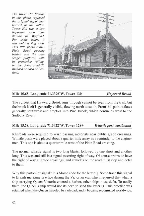
Mile 12.31, Longitude 71.2768˚W, Tower 175+ Tell- tale
Today railroad freight cars have air brakes, which are applied by the engineman through pneu-matic hoses connected when cars are assembled into a train. But
This cartoon appeared in Puck, November 17, 1909. In it, artist Udo J. Keppler depicts Presi-dent William H. Taft unknowingly in political danger. The caption reads: “The Unheeded Telltale: But there is still time to duck.” The dangling strings represent nine insurgent senators who broke with Taft’s policies. In 1909 most people had probably seen tell-tales, but the publisher included this note defining them: “A telltale is a bar to which strips of leather or rope are attached to warn brakemen on freight trains when they are approaching a bridge or a tunnel.” (Library of Congress)
35
before 1868, when the air brake was invented, every car had its own mechanical brake, applied separately. For boxcars this meant turning a large wheel mounted on top of the car. Brakemen had to climb to the top of a car and turn that wheel, and even jump a 30-inch gap to the next car while the train was in motion. This was especially dangerous when the train was at or approaching a place where the brakeman had inadequate headroom, for example, inside tunnels, under bridges, or, as here, within bridges with “ceilings.” If the train was moving toward such a place, the brakeman needed something to warn of the impending danger. That’s what tell-tales do. They were placed 100 feet from the dangerous obstacle.
This tell-tale has a single rail as a post, anchored in a concrete foundation, with a crossarm from which dangle pieces of wire. They are long enough to hit a brakeman standing in a roof walk, who would thereby be warned and would duck. Quickly.
Brakemen did not have high status in railroads. Not only was their job dangerous, but if they used too much force in applying a brake, causing the wheel to lock and develop a flat spot, they had to pay for a new wheel, which cost them about a month’s wages.
After air brakes were invented, it took a long time for earlier cars with mechanical brakes to be upgraded or taken out of service. Only after that process was complete could a rail line safely operate without tell-tales. Roof walks were mostly gone by the late 1960s. By then this railroad did not have much money, so deferred main-tenance was routine. Rather than remove the obsolete tell-tales, it was cheaper just
The trestle bridge and its associated tell-tale are both Treasures. This view, looking west, shows that the curve in the track extends through the narrow bridge. This unfortu-nate feature, a result of the original route layout in the 1870s, caused problems for railroad operations in later years. Banking the tracks to provide pas-senger comfort made some slow freight cars tip so much they were in danger of scraping the side of the bridge. (Photo by Valerie Mertz)
36
to leave them in place. When a group of railroad historians hiked this trail in 2016, they commented that standing tell-tales are rare and were delighted to see one.
Naturally a similar tell-tale was required on the other side of the bridge, for east-bound trains. There was one, but it was knocked over in a freight train derailment March 15, 1976. Three other bridges in Weston, at Church Street, Conant Road, and Concord Road, also required tell-tales. Some of their concrete foundations are still visible. Wayland had no need for tell-tales.
This trestle bridge carried the Central Massachusetts Railroad over the Fitchburg Division of the Boston and Maine Railroad, now the MBTA Fitchburg line. It is one of only three bridges of its type still standing in Massachusetts. From the bridge, look north along the Fitchburg line and you will see part of the parking lot for the Kendal Green Station at Church Street.
When the Massachusetts Central Railroad started operating in 1881 a bridge was needed at this place. That bridge was a type known as Warren Truss. In 1887 a poorly designed Truss bridge of another type in Boston failed, and shortly there-after the Massachusetts Board of Railroad Commissioners recommended that the Central Massachusetts Railroad upgrade all its Truss bridges. Likely in response, the original bridge was replaced in 1896 with this new Lattice Thru Truss bridge that is still standing. The granite foundation blocks from the original bridge were retained and still support the existing bridge.
The railroad tracks through this bridge are curved. Railroads generally bank tracks in a curve so that passengers are not thrown to the outside of the curve. This is known as superelevation. You can see this if you look carefully at the tracks on the bridge (see photo on page 35). The outer rail (on the north side) is higher than the inner rail. When the railroad had an extra wide load, the slow freight boxcars would tilt because of the superelevation and were in danger of scraping the side of the bridge. In these cases, a crew was sent out to shim the inside rail. This is an example of how a design decision (putting a curve where there had to be a bridge) resulted later in higher operating costs.
This historic bridge is not visible from the trail. Stony Brook, after passing under the bridge, can be seen to the south. The arched barrel-dressed voussoir bridge is 76-feet wide, with a clear span of 16 feet 9 inches.
37
Mile 12.61, Longitude 71.2815˚W, Tower 171+ Solar panel array
Solar panels sit atop the landfill near the town’s Transfer Station. Put into service on April 14, 2016, they generate about 40% of the electricity needed by Weston schools and other town-owned buildings.
Mile 12.66, Longitude 71.2824˚W, Tower 170+ Duck Pond vista
Duck Pond is one of Weston’s beloved conservation assets. Paths lead to the adjacent Sears Conservation Land. The attractive view from the trail is certainly a Treasure.
Mile 12.72, Longitude 71.2834˚W, Tower 170– Land’s Sake tree farm
Land’s Sake, a Weston nonprofit educational farming-oriented organization, has several fields where its members can cut evergreen trees for holiday decorations. Two are visible from the trail. Land’s Sake also operates a greenhouse and some bee hives near the trail just west of here. Its main farm is at 90 Wellesley Street.
Mile 12.77, Longitude 71.2845˚W, Tower 169+ Block signal foundation
The railroad had a single track all the way through Weston except for a passing siding at Weston Station (and three separate spur tracks for loading and unloading
freight, near Weston Station, Concord Road, and Warren Avenue). Eastbound and west-bound trains could get by each other if one was directed to the
No photographs of the Weston block signals are known. The sig-nal at the right in this photo is an identical one in Clinton. The Cen-tral Mass. book can be purchased at Wayland Station (Mile 16.77). It was a cooperative project with contributions from many peo-ple. Two often mentioned are the late H. Bentley Crouch of Weston and Richard Conard of Wayland, co-author of this field guide. (Photo by Donald S. Robinson)
38
passing siding while the other rolled by on the main track. Railroad people call this a “meet.” This was also how a passenger train could overtake a slower freight train; in railroad terminology, this is a “pass.”
The maneuver worked if visibility was good, because the engineman of a train scheduled to meet or pass another would be able to see which track was clear and act safely. However, at two places, here and in Clinton, visibility was not good. In Weston the railroad had reverse curves (two curves forming sort of an S shape) that blocked the view.
A wreck in Weston on April 12, 1904, caused multiple injuries. Two trains collided when one did not fully clear the passing siding and the other did not stop in time. After this event, two block signals were installed, one east of the passing siding and one west. These signals are long gone; but their concrete foundations can be seen, one of them here.
They were semaphore signals, activated automatically. A train in the block (the section of rail between signals) could be detected because it completed an electri-cal connection between the two rails. When there was no train in the block the sig-nals would display CLEAR. When a train was detected, headed in either direction, both signals would display STOP.
The special procedure for Weston was that if two trains were scheduled to meet or pass at Weston Station, the first one to arrive would see the CLEAR signal and proceed into the block and then stop. The second one to arrive would see the STOP signal. It was required to stop but could then proceed under “full control.” That made each train slow enough that it could stop if in danger of hitting the other.
The other end of this block is at Mile 13.67, almost a mile west, where there is another block signal foun-dation. The passing siding, removed many years ago, cannot be seen today.
This milemarker was carefully restored to its orig-inal appearance. The white and black areas are painted directly on the stone. It is in its original place along the Wachusett Greenway, in the town of Rutland. The milemarkers in Weston and Way-land can look like this if they are similarly restored. (Photo by Alan LePain)
39
Mile 12.82, Longitude 71.2853˚W, Tower 168+ Block signal electric pole
Block signals were run by electricity. Wires for both control and power were run on wooden poles just like today. In Weston all that remains of these wooden poles used for the block signals are a few short stumps, the biggest of which, here, is less than three feet tall.
At first glance this stump resembles an old tree stump, but look carefully and you will see that it has no roots showing at ground level and there are dark streaks on the outside near the ground. Then notice the stump is hollow. Wooden electric poles of all kinds (telegraph, telephone, power, radio, cable, fiber) are treated chemically to keep them from rotting. Early poles were coated with creosote, which is dark and diffuses an inch or two into the wood over time. After this pole was cut to its current height, the inner part, where the creosote did not reach, rotted away.
This granite monument is a milemarker. Central Mass enginemen did not have GPS devices, so a large visible stone like this one, with the mileage painted on it, was very useful. If you look carefully you will see that the bottom of the stone has a rougher surface than the two faces at the top. The stone originally was painted with a black stripe at the bottom of the smoother surfaces, and white above, with the letter B above the number 13 painted on the face seen by an eastbound train. That means 13 miles to Boston. On the other side was painted the letter N above the number 91, meaning 91 miles to Northampton, the western end of the line. For every milemarker the numbers on the two sides add up to 104, the overall length of the railroad line. There are two other milemarkers along the trail in Weston and two more in the eastern part of Wayland.
These milemarkers served passengers as well as crew. Probably this railroad’s most famous passenger was Calvin Coolidge, Governor of Massachusetts and later Presi-dent of the United States from 1923 to 1929. Coolidge, a lawyer, lived in Northamp-ton. After being elected Governor in 1918, he used the Central Massachusetts Rail-road to get between Northampton and his office in Boston. Surely he knew about and was informed by the milemarkers, probably including this very one.
The large square metal box is part of an underground pipeline that delivered fuel oil to Waltham from Fall River, some 50 miles away. The pipeline was completed about 1940 and remained in service about fifty years, including through the Sec-ond World War. There are six boxes like this along the rail trail, together with numerous white posts warning people not to dig there. Whether this pipeline is historic is debatable, but these valve boxes are definitely not the most beautiful Treasures on this trail.
40
Mile 13.02, Longitude 71.2892˚W, Tower 166– Forbes Conservation Land
This 2.5-acre pocket of town conservation land is located just off the rail trail. Looping paths lead visitors through upland red oak and pine forest and three wet-
land zones: swamp, marsh, and pond. Celeste Forbes, a founding member of the Weston Garden Club, developed the area as a wildflower garden and, with her husband Mac, donated it to the Town of Weston in 1985. Begin-ning in the early 1990s, Weston Garden Club cleared paths, installed maps, and built bridges, opening the property to the pub-lic in October 1992. In 2017, to commemorate the 25th anniver-sary, the garden club updated trail maps, replaced aged botanical markers, removed invasive spe-cies, extended boardwalks, and improved bridges. The Weston Forest and Trail Association and Town of Weston also help with maintenance.
The Sears Conservation Land, about 82 acres, is located south of the rail trail. Its extensive network of trails connects to the rail trail here. About 100 feet along this entrance path lies a borrow pit, which is a place where dirt and gravel have been removed for use as fill in road or railroad construction. In this case the material was used in the 1870s to create a berm to the east for the Massachusetts Central rail-bed. A borrow pit has a characteristic conical shape produced by removing material from the side of a hill and then letting the surrounding hillside collapse into the pit, where its soil can be collected easily. Tall trees have grown in this borrow pit; but its shape, with sides at the angle of repose, is still unmistakable.
Mile 13.22, Longitude 71.2916˚W, Tower 163+ Church Street vehicle access
Fire trucks, ambulances, police vehicles, maintenance trucks, and repair equip-ment can use this entrance to get on the rail trail. This may include very large
The Forbes Conservation Land invites you for a visit. Located directly on the rail trail yet with its own shaded habitat, it gives visitors a refreshing change of scenery. (Photo by Pamela W. Fox)
41
Eversource cherry-picker trucks to repair the high-voltage electric lines, should they get damaged. Other motorized vehicles are not allowed on the trail.
Mile 13.23, Longitude 71.2932˚W, Tower 163+ Tell-tale foundation
This concrete tell-tale foundation is close to the east side of the Weston Station. Exposed on the surface is a cross-section of the pole, which was made from an old rail. Tell-tales (see Mile 12.31) warn people on the top of boxcars about approach-ing dangers, in this case the Church Street bridge a hundred feet to the west. There were two railroad tracks here, one serving as a passing siding. Because this tell- tale had to extend over both tracks, it was strung between two poles. The other pole foundation, on the north side of the tracks, will be lost when the rail trail is built right over it.
Mile 13.24, Longitude 71.2934˚W, Tower 163 Weston Station (1881)
Weston Station originally sat about 200 feet west of its current position but was moved in 1911 when the Church Street bridge was built. For decades the station agent on duty was well known and liked by folks in town. The station closed on Feb-ruary 11, 1954. The building was later sold; but until the termination of passenger service in 1971, the new owner was required to keep it open so commuters could wait inside for their trains. The building is still private property, although it sits on state-owned land. See page 13 for an article about this remarkable building.
View of Weston Sta-tion in 1952 show-ing the gable-on-hip roof used for the important Central Mass. stations. Way-land Station has a similar roof, wide overhang, and large truss brackets. The photo also shows the main track and pass-ing siding. (R. Rich-ard Conard Collec-tion)
42
Mile 13.26, Longitude 71.2937˚W, Tower 163– Church Street stairway (1911)
This stairway extends from the Church Street sidewalk down to the passenger platform 22 feet below. It was one of several ways people could get to and from the trains. They could ride in carriages or automobiles. They could walk down the Church Street spur and pass by the station. Or they could follow trails through the nearby woods. In fact, in a spirit of neighborly good will, the owner of one prop-erty, Horace Sears, maintained a trail with that very purpose, for the benefit of his neighbors. It was even illuminated after dark.
The Church Street bridge has a very unusual shape. First, it has two arches. The larger one is wide enough for two railroad tracks and the smaller one for vehicle access to the freight spur track. Secondly, extending out from the east side it has a stairway resembling a buttress, connecting to the Church Street sidewalk. (Photo by Valerie Mertz).
Looking east at the Conant Road bridge in January 1988, five months prior to its demolition. The high elevation in the middle blocked motorists’ views of oncoming traffic. Wooden bridges are more suitable for roads without heavy truck traffic. The truck weight limit on this bridge was about four tons per axle. (Photo by R. Richard Conard)
43
The stairway has 38 steps, with a small landing in the middle. It was built between the two separate arches of the Church Street bridge. The stairway arch itself has an interesting design. One end is on the ground but the other is attached to the bridge at a higher elevation. This is called a “rampant” arch. This name comes from medieval heraldry. A symbol of strength and power was an animal, especially a lion, standing on its hind legs, ready to fight. That posture was known as rampant. The Scottish flag has a rampant lion. Today that word has two other meanings. The common one refers to anything running out of control, and hence dangerous. The other refers to an arch that is supported at different elevations on opposite sides.
Please do not go on the stairway. It needs repair. Some of the railings have broken apart, exposing sharp edges.
Mile 13.27, Longitude 71.2939˚W, Tower 163– Church Street bridge (1911)
This bridge was built in 1911 as part of a grade crossing elimination program that also included the Concord Road bridge (see Mile 14.01). Before 1911, there were actually two grade crossings here, just a hundred feet from each other. One was for Church Street and the other for Old Road. Both roads were relocated in 1911. Old Road had previously diverged from Church Street just south of the railroad (see map on page 15). Every time a train came by, two sets of safety gates had to be closed and then opened. These gates were operated manually.
The bridge has two separate arches. The wider arch on the north accommodated two tracks, the main track close to the station building, and the passing track just to its north. The smaller arch on the south is wide enough to accommodate a track but none was ever put there. Instead, this arch was used by a wagon that carried freight between the freight platform, on the west side of the station, and boxcars on a freight spur track west of the bridge.
The Massachusetts Central Railroad was ordered in September 1881 to build this bridge, thereby raising the elevation of Conant Road by about 19 feet. The road had no name at that time and was referred to as “the highway running nearly North from Weston Village near lands of Sumner Viles, Marshall Hews, William N. Gowell and Col. Daniel Lamson,” although the names were often misspelled. Subsequently it was called Forest Street and later Conant Road.
The original 1881 bridge was a timber frame trestle bridge. Fifty years later it required replacement, and in 1937 a similar bridge was built. Both made the eleva-tion of the road so high in the middle that motorists could not see traffic approach-ing from the other side.
In 1988, it was determined that the 1937 wooden bridge was not strong enough
44
to accommodate heavy trucks. Since trains were no longer running, there was no need for a bridge. It was simply demolished in place and the roadbed filled in. As a result the hump above the old tracks was removed and motorists found the visibil-ity better. To get across Conant Road, people on the informal trail next to the rails had to go up, over, and down.
The new rail trail is being built before there is any safe way to cross Conant Road. The trail will simply stop at a dead end on each side. If you encounter this blockage, please obey posted signs and do not attempt to climb up to reach the road. Not only is this dangerous, but it tends to destroy the embankments through erosion, and it goes across private property. Sorry. You will have to turn around and go back.
Mile 13.61, Longitude 71.3005˚W, Tower 157– Tell-tale foundation
This tell-tale (see Mile 12.31) was located 100 feet west of the Conant Road bridge to serve east-bound trails.
Mile 13.67, Longitude 71.3016˚W, Tower 156 Block signal foundation
There were two remote electric block signal posts, one on each side of the block of track that included the passing siding at Weston Station. This is the western one. See Mile 12.77 to learn why these block signals were unusual but necessary.
The Cherry Brook Station was never anything much more than a simple shelter. Over the years there were various versions of different sizes and shapes. Before 1911 it sheltered the safety gate operator as well as passengers. The flag is not in the stop position so the train may not stop to pick up this passenger. (Carlton Parker–Norton Clark Collection)
This is the middle one of three granite milemarkers in Weston (see Mile 12.97).
Mile 13.97, Longitude 71.3079˚W, Tower 151+ Cherry Brook Station site
The shallow depression in the land is where Cherry Brook Station once stood.After the railroad went bankrupt in 1883, it was more than two years before ser-vice restarted. The day it did, September 28, 1885, was a happy one for local com-muters. Herbert Merriam celebrated by giving the conductor a watermelon. His daughter Jessie gave him flowers.
During much of its lifetime, this station was a flag stop, meaning trains would stop to pick up passengers if the flag (a piece of metal atop a pole) was rotated properly. There was no agent after 1913, but trains continued to stop on demand. In 1980, the passenger shelter was abandoned along with the rest of the railroad assets. After years of neglect and vandalism, it was demolished in 1999.
Before the bridge was built in 1911, Concord Road crossed the railroad track next to the station. After the bridge was in place, the original road, both north and south of the railroad, was retained for access to abutting houses, modest parking, and pedestrian use. A gate here will allow emergency and maintenance vehicles to access the rail trail.
This bridge was built in 1911 as part of a grade crossing elimination project that also included the Church Street bridge (see Mile 13.27). The span was built wide enough to accommodate two tracks, because at that time there was thought of extending the railroad toward Springfield. The expected additional traffic would have justified double tracking. That did not happen, and there never was more than a single track here.
When this railroad was laid out in the 1870s, it passed through farmland in some places. Farmers needed to move their livestock across the tracks safely, so large culverts called cattle passes were provided. Five have survived to this day, four in Weston and one in Wayland.
46
There are two styles of cattle passes along this trail. Rail top cattle passes (this one, one more in Weston, and one in Wayland) had solid tops over which the rails ran. The side foundations, wing walls, and top were all made of reinforced concrete, which was not used before 1903. This cattle pass dates to 1921. Iron stringer cattle passes, the other style, are older. That style is described below at Mile 14.62.
The reinforced concrete in the tops of these rail top cattle passes is unusual in that instead of reinforcing rods, old sections of rail were used. That material was very strong and readily available. The rails were simply positioned next to each other all the way across the culvert, and concrete was poured onto and between them.
This cattle pass is typically dry and can be accessed for a close-up view of its con-struction. It is on land owned in 1908 by grandchildren of Isaac Fiske (1778–1861), a prominent community leader whose law office still stands on Boston Post Road.
The culvert that Cherry Brook runs through cannot be seen from the trail, but the brook itself is usually visible, flowing from south to north. This brook drains much of the nearby land and then enters into the Sunday Woods conservation area and thence into College Pond, part of a popular Weston recreation area. It then flows through what was the Cherry Brook Farm, run by prosperous gentleman farmer Herbert Merriam, the one who presented a watermelon to the conductor in 1885 (see Mile 13.97). The brook then crosses Merriam Street and Conant Road before joining Stony Brook, which eventually empties into the Stony Brook Reservoir.
These warehouses are on private property. The area near to them is used by a local landscaping company. The buildings have curved outer walls that align with a curved spur track running from the railroad. Note the high doors that match the height of boxcar doors. Freight for the local lumber yard was unloaded directly from boxcars into these buildings.
Mile 14.53, Longitude 71.3181˚W, Tower 144+ Jericho Town Forest trailhead
Weston is privileged to have an outstanding trail network on its conservation land. The trail that crosses from the trailhead just south of the rail trail is one of four that lead north into Weston’s largest conservation area, Jericho Town Forest. Within this area are the Dickson Riding Rings, a popular destination for horseback riders.
This area once had many farms, so there are stone walls, old farm roads, and three
47
cattle passes between here and Wayland. While this region has its own interesting history, it is most appreciated today for its well maintained trails. The Weston Forest and Trail Association publishes a town trail map that can be purchased at Weston Town Hall. Anyone exploring this Treasure of the Trail should have this map.
This cattle pass was made from reinforced concrete (see Mile 14.10). You can see right through it from the Jericho Town Forest trailhead, so it can be appreciated by people in wheelchairs. Unfortunately it is generally damp or wet inside, but similar cattle passes at Mile 14.10 and Mile 15.89 are not and so may be preferred by those who want to examine a rail top cattle pass more closely.
This cattle pass and another older one a hundred yards west (see Mile 14.62) are on land that was once the Flagg Farm, purchased by John Flagg in 1774. He built a tavern near what is now Boston Post Road that served travelers for 75 years, host-ing such notables as George Washington and John Quincy Adams. The land was purchased in 1870 by Harriet Emerson, wife of a prosperous Bostonian. Within a few years the Massachusetts Central Railroad started buying up land for its tracks, including a strip across the Flagg Farm. Presumably cattle passes were needed right from the start. Thirty years later, when Harriet’s son George Emerson owned the farm, the historic Flagg Tavern burned to the ground.
George was a colorful character, not at all admired in town. He lived in a rundown shack near the remains of the tavern, surrounded by rubbish and junk. One win-ter his horse died in his front yard, and he refused to move the body until spring. He raised and trained gamecocks and won first prize for his “Blue Breasted Pit Game cockerels and pullets” at a poultry show in Boston in 1913. His prize poultry undoubtedly participated in the illegal cockfights held in his barn and often raided by police.
This is one of two 1891 iron stringer cattle passes in Weston. The other is further west at Mile 14.81. This style differs from the rail top cattle passes at Mile 14.10. The iron stringer cattle passes had granite block side foundations and four iron stringers (otherwise known as I-beams) across them, parallel to the rails. Ties were placed directly on those stringers, and rails were run across the ties. This means the sky was visible from inside the passes. Sunlight illuminated the interiors, and passing trains were louder.
This cattle pass is on land that was once the Flagg Farm and later owned by the same
48
George Emerson described at Mile 14.54. Over the years adjacent wetlands have encroached, so the interior is overgrown and wet. Examination of this style cattle pass is easier at the other iron stringer cattle pass at Mile 14.81.
Mile 14.63, Longitude 71.3199˚W, Tower 142+ Gun Club Lane crossing
Gun Club Lane is a private way, created and maintained not by the state or town but by residents living on the road. In this case there are only two or three houses, all to the north. There is no access to Jericho Town Forest in that direction. Please respect the privacy of the residents. This grade crossing will provide trail access for emergency and maintenance vehicles.
This is one of two 1891 iron stringer cattle passes in Weston. The other is further east at Mile 14.62. This one was on a farm owned by Charles H. Fiske Jr., the great grandson of Isaac Fiske, whose grandsons owned the farm near Concord Road with the rail top cattle pass at Mile 14.10. Because it is usually dry, this cattle pass is easy to access and examine.
Maintenance of railroad tracks was normally organized in sections, each with its own crew. This section marker is at the boundary between sections 320 and 322.
This is the farthest west of the three granite milemarkers in Weston (see Mile 12.97). Even though it is at the bottom of the embankment, it could still be seen from trains.
Because they are so heavy, it was not easy for railroad workers to transport rails. The rails used by the Central Massachusetts Railroad were 33 feet long and weighed 85 pounds per yard. From that you can figure out how much a single rail weighs (hint: it is a bit less than half a ton).
Occasionally an existing rail needed to be replaced, so it was handy to have a sup-ply nearby. A rail rest is simply a place to keep a few rails available when needed. This rail rest consists of three reinforced concrete posts about 15 feet apart, each with a flat top surface big enough to accommodate three rails. Each surface had protruding steel retainers to keep the rails from sliding off. Originally, rail rests
49
were placed every mile or so along the track, but not many have survived. This is the only one in Weston; there is another in Wayland (see Mile 16.10).
If you find a rail here (or anywhere along the trail), you may be able to see what is called the rail brand. This is lettering on the web of the rail (its side) identifying it by the name, location, or abbreviation of the plant where it was made, the year and sometimes month of manufacture, and other information. This railroad used rails from many sources, including Bethlehem Steel, Krupp, Lackawanna, and others. A few rails have survived from the late 1800s, but most in Weston and Wayland are replacements from the early 1900s. One rail brand found at this location is “85A BSCO MARYLAND III 1919 85LBS ASCE” where BSCO means Beth-lehem Steel Company; the plant is their steel mill in Sparrows Point, Maryland; III means the month, March; 1919 is the year; 85LBS is the weight per yard; and ASCE stands for American Society of Civil Engineers, a professional society that, among other things, maintains technical standards.
At 174 feet above sea level, this was the highest point of the railroad in Weston and Wayland. After trains passed here in either direction, they started going downhill and could pick up speed. This point is a watershed divide, like the continental divide. Rain hitting the ground to the east flows into Cherry Brook and eventually to the Charles River. Rain landing to the west flows into Hayward Brook and even-tually to the Sudbury River, and thence to the Merrimack River.
Demonstrating the function of the iron stringer cattle pass at Mile 14.81 is Chloe Sullivan, with a calf belonging to Alex Anza, a member of the Weston Agricultural Commission. (Photo by Gloria Cole)
50
WaylandMile 15.30, Longitude 71.3331˚W, Tower 134 Town line bound, Weston/Wayland
The boundary between Weston and Wayland is not well marked on the railroad right-of-way. On Massachusetts highways such boundaries are usually noted with a sign saying that you are “Entering Wayland,” for example. But there is another, older type of marker consisting of a granite post that is often overlooked. In New England, boundary markers, also known as “bounds,” are found not only next to roads or paths but anywhere the boundary changes direction.
This custom came with the early settlers. Markers of some kind have been used in England and other countries for centuries to indicate boundaries between cities and towns, or even large estates. There was a practice of “beating the bounds” where villagers or land owners would “perambulate” (walk around the perimeter), once a year. They would check that the boundary markers were where expected, and would beat them with a stick as a way of reminding themselves where they were found. Some people say that in the case of estates, children were expected to perambulate with their elders, and “beating” referred to kids being hit by a stick at each marker by an adult or older sibling as a way of teaching the next generation where the estate boundaries were located.
As early as 1634 town officials in Massa-chusetts were required to perambulate annu-ally (although there was no expectation they would beat either the bounds or each other).At that time Weston was part of Watertown. Originally, boundary markers were often nat-ural features, like easily identified trees or even distances from nearby houses or far. Per-ambulation consisted of visiting each bound, not necessarily in order, in the company of officials from the town on the other side of the boundary. By 1692, at least two selectmen
This granite monument on the Wayland-Weston border must have been installed after 1835 because the initials are both “W.” Before 1835, Wayland was called East Sudbury. The carved town initials do not, at least in this case, indicate which town is where. (Photo by Jim Metcalf)
51
or their delegates were required to perambulate or else pay a fine of £5. In 1713, Weston was incorporated and presumably perambulation was required from the start. By 1785, it was required only every five years, and the fine for non-compli-ance was $20.00. In 1827, state law required more permanent bounds in the form of granite posts with the initials of the adjacent cities or towns carved in them, at every boundary corner and next to every road.
Today only two states, Massachusetts and New Hampshire, still mandate peram-bulation by municipal officials. Current Massachusetts law requires that every five years two selectmen, or others designated in writing, search for all the known bounds, report their findings to adjacent communities, paint the year on the mark-ers that are found, and repair or replace damaged, leaning, or missing markers. There is no penalty for failure to perambulate, but there is a penalty of $20.00 if needed repairs or replacements are not made.
At this point on the trail where Weston meets Wayland there is a granite post about four feet high on the north side of the trail, just outside the right-of-way. The required initials “W” and “W” are carved on the two sides, though they have worn down over the years and are hard to see.
This Wayland grade crossing, closest to the Weston town line, will provide trail access for emergency and maintenance vehicles.
Mile 15.53, Longitude 71.3375˚W, Tower 131+ Tower Hill Station site
A clear area used today for parking is the site of the Tower Hill Station, on the south side of the trail. The building, erected in 1881, burned about 1890. Its replacement was in operation through 1920. It was designed in the same general style as the nearby Weston and Wayland Stations, but without roof overhangs on the ends.
In the early 1950s the railroad built a simple wooden open-air shelter between the closed station and the tracks. About ten years later it tore down the station and then it was only another ten years before passenger service stopped completely. Finally the derelict shelter was demolished in 1996 after years of neglect and vandalism.
Mile 15.55, Longitude 71.3378˚W, Tower 131– Tower Hill Station platform
The Tower Hill Station served passengers but had no freight service. The passen-ger platform, on the south side of the tracks, had a wooden railing to keep passen-gers from falling down the embankment into wetlands while waiting for trains. Some of the original posts and railings can be seen today.
The culvert that Hayward Brook runs through cannot be seen from the trail, but the brook itself is generally visible, flowing north to south. From this point it flows generally southwest and empties into Pine Brook, which continues west to the Sudbury River.
Mile 15.78, Longitude 71.3422˚W, Tower 128+ Whistle post, eastbound
Railroads were required to warn passing motorists near public grade crossings. Whistle posts were placed about a quarter mile away as a reminder to the engine-men. This one is about a quarter mile west of the Plain Road crossing.
The normal whistle signal is two long blasts, followed by one short and another long. This was and still is a signal asserting right of way. Of course trains do have the right of way at grade crossings, and vehicles on the road must stop and defer to them.
Why this particular signal? It is Morse code for the letter Q. Some trace this signal to British maritime practice during the Victorian era, which required that when a ship carrying Queen Victoria entered a harbor, other ships must defer. To notify them, the Queen’s ship would use its horn to send the letter Q. This practice was retained when the Queen traveled by railroad, and it became recognized worldwide.
The Tower Hill Station in this photo replaced the original depot that burned in the 1890s. Tower Hill was a less important stop than Weston or Wayland. For some trains it was only a flag stop. This 1915 photo shows Plain Road passing behind and the pas-senger platform, with its protective railing, in the foreground.(R. Richard Conard Collec-tion).
This rail rest served the same purpose as the one in Weston, a mile to the east (see Mile 15.08). The middle post is leaning but it retains its original shape.
Mile 16.13, Longitude 71.3489˚W, Tower 124+ Whistle post, westbound
This whistle post (see Mile 15.78) was oriented to be visible to enginemen of trains headed west. It is located a quarter mile east of the Glen Road crossing.
The Mill Brook culvert cannot be seen from the trail, but the brook itself is visible, f lowing north to south. Upstream 750 feet is Mill Pond, site of a grist-mill for grinding corn, built in 1639 by Thomas Cakebread (yes, that really was his name).
The much smaller Tower Hill passenger shelter at left conveys the image of a much simpler operation. Indeed, it was taken in January 1969, only two years before the last passenger train stopped here. (Photo by R. Richard Conard)
54
Mills continued in this location, under a variety of names, for 250 years. Today Mill Pond is popular with ice skaters.
Mile 16.53, Longitude 71.3566˚W, Tower 118+ Ring post, westbound
When the engineman was approaching a public road, the ring post reminded him to ring a warning bell, used instead of a whistle when a quieter signal was preferred. This ring post is located about a quarter mile east of the Cochituate Road crossing.
This is the westernmost of three grade crossings in Wayland between the Weston town line and the Wayland Library. Extra caution is advised for trail users because motorists here have poor visibility.
Mile 16.63, Longitude 71.3585˚W, Tower 117+ Whistle post, eastbound
This whistle post (see Mile 15.78) is a quarter mile west of Glen Road. At some point it toppled and broke into a few pieces. The plan is to move it to a safe place to be repaired before being reset upright at its original location.
Mile 16.71, Longitude 71.3604˚W, Tower 115+ Freight house (1881)
Unlike many towns such as Weston, Wayland had separate buildings for railroad passengers and freight. The large freight house, now owned by the Town of Way-land, is the only freight house still standing on the entire Central Massachusetts line. It was recently restored and painted in authentic railroad colors. The sidetrack
The freight house doors are at the same level as boxcar doors. The stairs shown here are are of recent date. Orig-inally there was a long, wide loading platform at door height, located between the freight house and the boxcars on the adjacent sid-ing. It was big enough to hold a lot of freight shipments. (Photo by Paul Penfield Jr.)
55
next to the freight house has been preserved but not the loading platform. The high doors on the south side of the building match the height of boxcar doors.
This crossing is just south of where Concord Road (Route 126) diverges from Cochituate Road (Route 27). Wayland Library is nearby. Emergency and mainte-nance vehicles will be able to access the rail trail here.
The Wayland Historical Society Museum, located in the Grout-Heard House just south of the trail, welcomes visitors during open hours. The c. 1740 colonial house is thought to have been built by the grandson of John Grout, who ran the grist mill described at Mile 16.47 after Thomas Cakebread died.
Mile 16.77, Longitude 71.3618˚W, Tower 114+ Wayland Station (1881)
This passenger station was staffed from 1881 until 1949. It was bought by the Town of Wayland in 1970, just as passenger service was ending, and lovingly restored during the next ten years. Since February 1980 it has housed a nonprofit handicraft gift shop run by volunteers.
Wayland Station viewed from the southeast, about 1920. The building today looks very much the same. In the background at left is the 50,000-gallon water tank used to supply water to steam locomotives. Note the similarity in architecture with the Weston depot. (Wayland Historical Society)
56
Among its other wares, this shop sells the expanded second edition of The Cen-tral Mass., the definitive history book describing and depicting this now-defunct railroad. Its photographs, many of them taken by the late Ben Crouch of Weston, present all aspects of the hundred-year history of the railroad, both the good and the bad. You can see the dust jacket in the entry for Mile 12.77. This book itself is one of the Treasures of the Trail.
In 1887 commuter service between Wayland and Boston increased, and Wayland became the turn-around point for trains that did not go further west. Additional facilities were needed. Cars needed sidings to park on overnight or when not in use. Locomotives needed a convenient way to turn around for the trip back to Bos-ton. They also needed routine maintenance and water. Engine fires had to be kept burning overnight at a low level so the locomotives would be ready to go in the morning. About the only things missing seem to be a repair shop and a coal chute, both available in Boston.
Four parallel passing tracks were built, each with switches at both ends. Cars and locomotives could be moved from track to track as necessary. One of the switches has survived. Take a look at this Treasure of the Trail to see how track switches work.
This section of the rail trail was built in 2017 by the Town of Wayland. Part of the main line track and some of the other siding tracks were left in place to remind trail users of the hustle and bustle of a vibrant rail yard 130 years ago.
Mile 16.82, Longitude 71.3628˚W, Tower 113+ Water tank foundation (1887)
Fifty feet north of the trail lie brick and granite foundations from the 50,000-gal-lon water tank, 24 feet in diameter and 35 feet high. This tank was built in 1912 to replace an earlier one from 1887. Water for the tank was pumped from the nearby engine house. Steam locomotives needed lots to drink. Wayland became a “tank town,” as many thirsty locomotives stopped here to take on water. If by chance you are now thirsty, look below at Mile 17.17.
Mile 16.85, Longitude 71.3632˚W, Tower 113+ Engine house foundation (1887)
A three-stall wooden engine house was built in 1887 to maintain and repair loco-motives and shelter them overnight. Locomotives entered and left the stalls via the adjacent turntable. Because the stalls were accessed from different positions of the turntable, they were not parallel; and the building was shaped sort of like a slice
57
of pie without the point.
In 1918 Wayland stopped serving as an engine terminal. Trains that formerly ended their run here were rescheduled to travel further west. The engine house, no longer needed, was sold and later demolished, in 1936. Only the foundation remains.
When Wayland was serving as an engine terminal, a turntable was used to redirect locomotives either back to Boston or into one of the stalls of the adjacent engine house. The locomotive was driven onto rails mounted on a steel frame, which was then rotated, by human power, to point the locomotive in another direction.
Some time after 1918 the turntable was no longer needed, so the steel frame was removed and the pit filled in with dirt.
In 1951 the electric transmission towers along the railroad right-of-way were erected by Boston Edison (now Eversource). By chance Tower 113 ended up right on the rim of the turntable pit. In 2007, under supervision of the Wayland His-torical Commission, volunteers started excavating the pit in order to reveal its structure. When you look at the turntable pit, you have to pretend not to see Tower 113 or its concrete foundation and instead imagine that the granite foundation con-tinues completely around the pit.
This is one of two granite milemarkers in this part of Wayland (see Mile 12.97).
The turntable had two granite-block rings. The inner, lower ring had a circular rail, on which sat a large frame with flanged wheels. Every-thing was so well bal-anced that the frame , with a railroad car or locomotive on it, could be rotated by human power. (Photo by Paul Penfield Jr.)
58
Mile 17.17, Longitude 71.3695˚W, Tower 108+ Shopping center
Thirsty? Hungry? Need ice cream? You have come to the right place.
Between the 1950s and 1990s the Raytheon Equipment Division designed, built, and tested a variety of electronic systems here, including radar systems and phased-array antennas, both military and civilian. After Raytheon moved out, its building was torn down and the “Wayland New Town Center” shopping area was built. Like all shopping centers, this one has plenty of places to eat. You’ve done the exercise, you deserve the reward. Bon appétit!
Mile 17.23, Longitude 71.3703˚W, Tower 108– Boston Post Road crossing
This crossing is often called Russell’s Crossing because it is near Russell’s Garden Center. The railroad and road are nearly parallel at this point, and this presented safety problems. Motorists could not see trains overtaking them without turning their necks a great deal. Bicycle and motorcycle tires sometimes slipped on the smooth metal rails or got caught in the flange gap next to the rails. Sometimes the rails stuck out above the paving. Large potholes developed next to the rails.
A gaudy nine-inch-high steel barrier rises from under the ground to keep cars away from a train in July 1947. (Photo by Donald S. Robinson)
59
In September 1936, an unusual mechanical barrier was installed at this crossing. When a train approached, a traffic signal would turn red. What happened next was bizarre. A steel barrier the width of the road and nine inches high would rise out of the road in front of the cars. Motorists seeing it for the first time were often mystified. On September 27, the Boston Sunday Globe reported on the new device saying that, after it goes into use: “the competition will then be open among idiot drivers to see who’ll be first to have his life saved at the expense of his automobile.” It lasted about 15 years before being removed.
Later, someone created a large sign advising bikers to cross the tracks at a right angle. That sign was in place on a utility pole in 1979 when a newspaper ran a story on the dangerous crossing. A year later, the last freight train passed through Rus-sell’s Crossing.
* * *
We hope you have enjoyed this hike through history. We have come a few miles, but ahead of us the abandoned railroad right-of-way continues, crossing over the Sudbury River and Great Meadows National Wildlife Refuge, then through the woods in Sudbury and on to points west.
It was 1844 when Wayland’s own Lydia Maria Child wrote the Thanksgiving poem that starts “Over the river and through the wood, to Grandfather’s house we go...” In her time transportation was by horse-drawn sleigh, usually for short distances. Forty years later, her poem could have described the Mass Central Railroad, on its way to Northampton. Soon it might fit the continuation of this rail trail. Who knows how far that will take us and what new Treasures of the Trail we will find?
A citizen-created sign warned bikers in 1979 to cross the rails at a right angle. There were very few trains still running, but the rails themselves were a hazard. (Wayland Town Crier, May 31, 1979)
60
OFFICERS, WESTON HISTORICAL SOCIETY 2017-18President: Pamela W. Fox
Co-Vice Presidents: Tom Brome and Tom FriedlanderCo-Secretaries: Liz Hochberger and Robin Reisman
Co-Treasurers: David Cail and Pam RiffinMembership Chair: Tom Friedlander
Bulletin Editor: Pamela W. FoxWebmaster: Robin Reisman
BOARD OF DIRECTORSMark Curelop, Nina Danforth, Tony Davies, Rebekah Gardiner, Jeremy Hagger, Liz Hochberger, Emily Hutcheson, Susan Littlefield, Kitty Smith, Robin Strickman, Sya-mala Swaminathan, and Molly Varnau. Madeleine Mullin, Weston Public Library Liai-son. WHS, P.O. Box 343, Weston, MA 02493. [email protected]. ISSN 1083-9712.
Membership dues: Individual $35, Family $50, Sponsor $75, Supporting $100+, Life membership $500. Tax deductible contributions and bequests to the Endowment Fund are welcome. Opinions are not necessarily those of the editor or Weston Historical Society. Please visit our website: www.westonhistory.org.
* There was an error in the numbering of the Fall 2017 Bulletin. The correct des-ignation should have been Volume XLVIII, No. 2.
To join the Weston Historical Society or for copies of this Bulletin, please visit our website, www.westonhistory.org. Members receive two issues of the Bulletin each year and invitations to programs and special events. We depend on member support to carry out our mission: to collect, preserve, and share items related to Weston’s community heritage.
This ticket was good for free rides on the Massachusetts Cen-tral Railroad on Opening Day, Octo-ber 1, 1881. (Wayland Historical Society)