151
MASTER DRAINAGE PLAN -,: .;-::'·-·-:·:: - . 1998 PEREZ I FREESE • NICHOLS. L.L.c;:. ······ 32338,Mec::ou ili:i:·Mo::Aiteii.lexasieeol · 956/63 h4482 Fax 956/682-1545
MASTER DRAINAGE PLAN
-,: .;-::'·-·-:·:: - .
City~ofAiton~WTexas
1998
PEREZ I FREESE • NICHOLS. L.L.c;:. ······ 32338,Mec::ou ili:i:·Mo::Aiteii.lexasieeol ·
956/63 h4482 Fax 956/682-1545
Table of Contents
~
1.0 Introduction 1.1
1.1 Basic Philosophy 1.1 1.2 Statement of the Problem 1.4
Changes In Hydrology 1.5 Resource Conflicts 1.5 Surrounding Jurisdictions 1.6 Economics 1.6 Summation 1.7
2.0 Assessment of the Existing Storm Drainage System 2.1
2.1 Study Area 2.1 2.2 Contributing Drainage Area 2.1 2.3 Storm Runoff Computations 2.4 2.4 Rainfall Intensity 2.5 2.5 Rainfall Data 2.6 2.6 Precipatation Losses 2.6 2.7 Lag Time 2.7 2.8 Hydrograph Routing 2.7 2.9 Contributing Drainage Areas Computed Peak Flows 2.8
3.0 Methods of Stormwater Management 3.1
3.1 Legal Consideration 3.1
3.2 Structural Alternatives 3.1 Conveyance Oriented Approach 3.1 Storage Oriented Approach 3.5 Federal Programs 3.8 Texas Legislation Related to Floodwater Management 3.10 Home Rule Authority 3.10
3.3 Nonstructual Altemati.ves 3.11 Governmental Controls 3.11 Municipal Drainage Regulations 3.14

Table of Contents (continued)
4.0
5.0
Stormwater Management Costs
4.1 4.2 4.3 4.4 4.5 4.6
Administration Planning, Design, and Engineering Regulation and Enforcement Operation and Maintenance Capital Improvements Summation
Financing Options
5.1 5.2 5.3 5.4 5.5 5.6 5.7 5.8 5.9
5.10
5.11 5.12
Summary of Financing Options General Fund Drainage Utility Service Charges Interfund Loans to Drainage Utilities General Obligation Bonding Repaid by Property Taxes Revenue Bonding Repaid by Service Charge Revenues Utility Tax Revenues Tax Increment Financing State Funding
Community Development Block Grant Funds Texas Water Development Board Funding
Fees and Charges Plan Review and Inspection Fees On-site Detention/Retention System Inspection Fees Impact Fees Development Assessment Charges System Development Charges (SDCs) General Facilities Charges Latecomer's Fee
Special Assessments Criteria for Evaluating Financing Options
Perceived Equity and Public Acceptance Flexibility Capacity Cost of Implementation Compatibility
4.1
4.1 4.2 4.2 4.3 4.5 4.5
5.1
5.2 5.2 5.3 5.5 5.5 5.6 5.7 5.7 5.8 5.8 5.8 5.9 5.10 5.10 5.10 5.12 5.12 5.14 5.15 5.16 5.17 5.18 5.18 5.19 5.20 5.20
Table of Contents (continued)
6.0
7.0
8.0
Upkeep Requirements Balance Timing Geographical and Jurisdictional Considerations
5.14 Summation
Administrative and Managerial Considerations
6.1 6.2 6.3 6.4 6.5 6.6 6.7
Scope ofthe Stormwater Management Program Storm water Management Functions Options for Program Administration Evaluating Administrative Options Public or Private Maintenance of Drainage Facilities Drainage District vs Drainage Utility Summation
Suggested Drainage and Stormwater Management Policy
5.21 5.22 5.23 5.23 5.24
6.1
6.1 6.2 6.2 6.3 6.5 6.6 6.8
7.1
7.1 Purpose 7.1 7.2 Suggestion for Drainage and Stormwater Management Policies 7.1 7.3 Application of Drainage and Stormwater Management Policy 7.3 7.4 Regional Stormwater Management 7.3 7.5 Drainage System Classifications 7.4 7.6 Drainage and Stormwater Management Plans Submittals 7.4 7.7 Floodplain Development 7.6 7.8 Drainage Structure Aesthetics 7.6 7.9 Drainage Design Computations 7.7 7.10 Construction of Drainage and Stormwater Management Facilities 7.7 7.11 Maintenance of Drainage And Stormwater Management Facilities 7.8
Discussion of Improvement Alternatives
8.1 8.2 8.3
8.4 8.5
Planning Criteria Corrdination with Surrounding Jurisdictions Drainage and Storm water Management Plans
Hydrologic Design Considerations Hydraulic Design Considerations
Preliminary Estimate of Probable Construction Cost Preliminary Estimate of Probable Annual Operation and Maintenance Cost
8.1
8.1 8.4 8.6 8.7 8.7 8.8 8.9
Table of Contents (continued)
9.0 Recommended Master Plan Improvements
9.1 9.2 9.3 9.4
Discussion of the Economic Feasibility Discussion of Safety Considerations Discussion of Environmental Concerns Discussion of Aesthetics
10.0 Implementation Schedule
10.1 Immediately, or during the First Year 10.2 The 1- to 5-year Period 10.3 The 6- to 1 0-year Period 10.4 The 11- to 15-year Period 10.6 Improvements that can be Accommodated as
Development Proceeds
Appendix A- List of References
Appendix B- Estimates of Probable Construction Costs
Appendix C- Texas Water Development Board Review Comments for the City of Alton Flood Protection Planning Contract- Contract No. 96-483-158 on the Final Draft Report
Texas Water Development Board Review Comments for the City of Alton Flood Protection Planning Contract - Contract No. 96-483-158 on the Final Report
9.1
9.1 9.2 9.3 9.4
10.1
10.1 10.4 10.4 10.6 10.6

List of Tables
Table Title Page
2.1 Summary of Computed Peak Discharge 2.3 for Existing Conditions, 1 0-year, 24-hour Storm
2.2 Rainfall Intensity Equation Constants 2.5
2.3 Rainfall Intensity-Duration Frequency 2.6
3.1 Typical Channel Improvements 3.4
3.2 Comparison of Conveyance and Storage Features 3.9
4.1 Typical Maintenance Costs for Drainage Facilities 4.4
6.1 Criteria for Evaluating Administrative Approaches 6.4
6.2 Factors Affecting Decisions About Ownership of 6.6 Stormwater Facilities
8.1 Summary of Preliminary Estiumate of Probable 8.10 Construction Costs
List of Figures
Figure After Page
10.1 Immediate, or During the First Year, Project No. I 10.3
10.2 Immediate, or During the First Year, Project No.2 1().3
10.3 The 1- to 5-Year Period Project 10.4
10.4 The 6- to 10-Year Period Project 10.5
Plates A-1 through B-3 are included at the end ofthe report text
1.0 Introduction
1.1 Basic Philosophy
Master Drainage Plan City of Alton, Texas
Upstream areas of urbanizing watersheds contribute to downstream stormwater runoff
problems simply because of the cumulative effects. In many cases, land development in upstream
areas has occurred with little thought of the consequences to downstream areas.
Many entities oflocal government are autonomous units primarily concerned with land use
and storm water runoff within their own boundaries. There are exceptions where municipalities
receive water or sanitary sewer services from outside areas. Sometimes conflicts have arisen among
adjoining communities, particularly over land use issues and its effect on the management of
stormwater runoff.
The basic philosophy on the need for watershed management within urban areas has, over
the past several decades, changed dramatically. Nationwide experience with the effects of
inadequate past practices indicates that stormwater has not always been well managed. This
experience has led to a major redirection in the way many communities perceive urban drainage and
attempt to deal with it effectively.
The City of Alton recognized the importance of addressing stormwater management and
contracted with Perez/Freese and Nichols, L.L.C., in March 1996 to perform a Master Drainage
Study and prepare a master plan for the management of stormwater for the City of Alton and its
Alton Master Drainage Plan Perez!Freese and Nichols, L.L.C.
Section I, Page I
surrounding extraterritorial areas. The study is funded in part through the Texas Water Development
Board Flood Protection Planning Study, contract No. 96-483-158.
The basic scope of work is as follows:
Task I. Base Mapping: Qkjective: To develop a digital planimetric and topographic
base map from existing mapping available from TNRCC Information Section within the
study area at I" = 400' scale.
Task II. Drainage Policy and Criteria Development: Objective: To review current
drainage guidelines for the City of Alton and Hidalgo Drainage District No. 1 that will
facilitate and establish fundamental drainage policies for the City of Alton. Drainage
Criteria, Ordinances, and Drainage Design Procedures will be written and proposed to
support the drainage policies.
Task III. Existing Storm Sewer Assessment: Objective: To evaluate and determine the
capacity of the existing storm sewer systems, detention pounds, open channels, and storm
sewers within the Study Area.
Task IV. Master Plan Development: Objective: To develop a master drainage p I a n
that will implement adopted drainage policies and criteria. The Master Plan will
correctly identify drainage system deficiencies and to provide a document that will lead
to an orderly development of the City of Alton and its extraterritorial jurisdiction. The
plan will also provide a working document for developers and engineers, including
recommended drainage easement widths and methods for determining pipe, channel or
detention structure sizes.
Alton Master Drainage Plan Perez!Freese and Nichols, L.L.C.
Section I, Page 2
Stormwater is a difficult resource to manage primarily because drainage systems are
constantly in a state of flux. Even a natural drainage system is not static: streams meander, banks
erode, lakes are filled by sediment. Urbanization compounds this problem because it increases the
rate and quantity of runoff, and urban runoff is often polluted with chemicals and litter that is carried
into the rivers and lakes. It is important to keep in mind that all development increases the
stormwater runoff and contirbutes to the problems.
The combination of increased runoff, erosion and excess sediment, and pollution at times
threatens public safety and properties and in turn damages the habitat of plants and animals
dependent on the streams.
A generally accepted concept is that property within a city should contribute to the remedy
of the problem caused by increased stormwater runoff. Two important principles underlie this
storm water management concept:
• First, that all real property within a city will be benefited by the installation of an adequate
storm drainage system;
• Second, that the cost of installing an adequate drainage system should therefore be assessed
against the real property in a city.
These principles are not easy for property owners to understand at first glance, but they are
the keys to an effective stormwater management effort. A property owner may not have a problem
immediately on his property, but he contributes a proportionate share to problems downstream. A
unified and safe drainage system is the benefit of the basin as a whole. Each property individual
Alton Master Drainage Plan Perez/Freese and Nichols, L.L.C.
Section 1, Page 3

should contribute to the improvements necessary to solve the problem.
The problems that exist today will not go away, and the longer they are put off the more
costly they will become to solve. Through advance planning, there will be fewer facilities and they
will be larger and more strategically placed to minimize long-term maintenance costs, and they can
be multi-purpose in use (for open space and recreation as well as for drainage).
Recognition that storm water management includes much more than just flood control is
important. Keeping streets open to emergency vehicle traffic, maintaining ponds and open channels
so they do not become health and safety hazards, and promoting the use of drainage facilities for
recreational purposes all contribute to enhancing and maintaining the quality of life for the entire
community.
1.2 Statement of the Problem
The City of Alton (like many other cities) has reached a point of "problem convergence"
related to management of storm water runoff from the watershed. A number of factors and conditions
have come together to pose a major challenge to the City. The growth and development of the
community are manifested in a long-term, often subtle, and pervasive change in the City's drainage
systems. Symptoms of the changes are evident in drainage system failures, localized flooding and
escalating costs of control. Unfortunately, there is no single cause or simple cure for the problems
of storm water management.
What are the factors which combine to make urban stormwater management a major
challenge in Alton? They are a diverse group of problems, circumstances, and conditions. When
considered separately, they do not fully indicate the seriousness of the situation. The seriousness
Alton Master Drainage Plan Perez/Freese and Nichols, L.L.C.
Section 1, Page 4

is apparent, however, when they are considered together. The four most prominent factors in the
present problems are changes in hydrology, resource conflicts, surrounding jurisdictions, and
economics.
Changes in Hydrology: As the City has grown, impervious surfaces such as rooftops and
pavement have covered over soils which were relatively pervious. An increasing proportion of the
precipitation which previously filtered through the soil to the groundwater has been repelled.
Instead, it is diverted by roofs and parking lots to channels and culverts, and carried to receiving
streams in the hydraulically most efficient manner, i.e., as quickly as possible in the smallest facility
considered being adequate.
Although Alton has some natural and manmade storm water detention or retention facilities
on developed sites, these systems are not coordinated to mitigate major storms. The overall impact
of urban development will result in large increases in runoff from smaller, more
frequent storms which may not be effectively controlled by on-site detention systems designed for
more severe events. The change in hydrology is a basic condition which must be recognized.
Resource Conflicts: Urban levels of development are rarely achieved without conflicts in
the use of resources, especially when storm waters impede potential uses of the land. Unfortunately,
land development in the Lower Rio Grande Valley area has not typically been achieved by solving
the drainage problems. More often the symptoms (like flooding) have merely been moved to another
location.
Urban runoff is a unique product of development. The quantity and quality of stormwater
runoff in Alton may pose major problems for the community in general. As new growth occurs in
Alton Master Drainage Plan Perez!Freese and Nichols, L.L.C.
Section I, Page 5

the area, resolution of short-term resource conflicts related to drainage control should be made with
a better vision of long-term needs and impacts. The alternative consequence is that economic and
social costs will continue to mount in the form of repetitive stormwater management problems.
Surrounding Jurisdictions: Storm water runoff does not recognize established jurisdiction
lines and close coordination with the surrounding communities (McAllen, Mission, and Palmhurst)
is essential for a successful master plan. The concept of a storm water management in a watershed
is not new. A coordinated effort can assist with the management of land within a watershed to
enhance the well-being and quality oflife of municipalities within the watershed. Once a decision
is reached to consider a coordinated watershed program, public meetings can be convened to help
promote the need for comprehensive stormwater management planning and subsequent
implementation. Ultimately, a regional stormwater management entity may be needed, as it is
difficult for individual units oflocal government to act on a watershed basis outside of their borders.
Hence, a regional entity is frequently needed to implement a comprehensive storm water management
plan.
Economics: The problems cited above, which are primarily physical, are compounded by
economic factors which make solutions more difficult to achieve. Texas cities are in a period of a
serious revenue shortfall in which programs oflong-standing are being closely scrutinized, trimmed,
and sometimes eliminated. This overriding revenue shortfall problem further exaggerates what has
always been a major obstacle to effective storm water control: the lack of stable and adequate local
financing upon which long-range programs can be based.
Lurking behind the immediate economic problems of local governments is an even more
Alton Master Drainage Plan Perez/Freese and Nichols, L.L.C.
Section 1, Page 6
imposing potential problem. Existing physical improvements of all types in the United States, both
public and private, are collectively growing old and wearing out. Many will have to be rebuilt or
they will fall apart within our lifetimes.
Regardless of what level of government will be responsible for rebuilding public systems,
it will meet intense competition for limited capital resources to finance the reconstruction. Private
industry faces many similar reinvestment needs, and many other costs of government are also rapidly
rising.
The demand for fmancing to rebuild large public and private systems will likely keep the cost
of money, in terms of interest rates, high throughout the next two decades. Even if federal policies
change regarding growth of the money supply and interest rates decline somewhat, it is likely that
prices will inflate again. Inflation in the construction industry has historically been higher than
average price inflation, driving the costs of public capital improvement projects up rapidly. This
economic "Catch-22" may be the most serious of all the problems that Alton's drainage program
must face.
Summation: The previously discussed factors create potentially serious situations as each
drainage problem is compounded by the effect induced by changes in the other factors. This
situation indicates the need to consider a comprehensive, balanced, and consolidated stormwater
management program.
Alton Master Drainage Plan Perez!Freese and Nichols, L.L.C.
Section I, Page 7

2.0 Assessment of the Existing Storm Drainage System
2.1 Study Area
The limits of the study area are illustrated on Sheet A-1 through 3-B in Section 8 of this
report. The study area extends from FM 107 on the north to Three Mile North on the south and from
Sharyland Road on the east to Moore Field Road on the west. The current city limits of Alton and
the city limits and the extraterritorial jurisdiction boundaries of the adjacent cities are also shown.
Stormwater runoff does not recognize jurisdiction lines, and close coordination with the
surrounding communities is essential for a successful master plan. During the development of the
Master Plan efforts have been made to keep the Cities of McAllen, Mission, and Palmhurst, as well
as the Hidalgo County Drainage District No. 1, informed about the progress and preliminary results
of the study. Continued coordination is recommended as the plan is implemented.
2.2 Contributing Drainage Areas
The City of Alton is located in a relatively flat area of Hidalgo County that falls primarily
from west to east. The heavily developed area of Alton is currently along either side ofFM 676.
Scattered residential and commercial development exists throughout the remainder of the study area.
FM 676 follows a slight rise in the ground surface. The terrain north of the road falls generally to the
north and east. The portion ofthe study area south ofFM 676 falls generally to the east and south.
The extreme western section of the study area is separated from the remainder by the Main Canal
and the Hidalgo County Drainage District No. 1 ditch. Runoff from this western area has not been
included in the sizing of the proposed drainage control facilities east of these two structures
presented in this study since these two facilities should intercept runoff from this western region.
Alton Master Drainage Plan Perez/Freese and Nichols, L.L.C.
--------------------
Section 2, Page I

Storm nmoff does enter the study area from the area north of FM 107. This outside nmoff
has been considered in the planning of the proposed drainage control facilities. The drainage control
facilities within this northern portion of the study area should be sized to limit the rate of inflow into
the Hidalgo County Drainage District No. I ditch to the same flow rate as under existing conditions.
Making this assumption should eliminate any effects on the City of Alton from this area. To achieve
this condition, close coordination will be required with the appropriate governmental entities and
irrigation districts as this portion of Hidalgo County is developed.
The remainder, and major portion of the study area, is crossed by many manmade features
such as irrigation canals and laterals, drainage ditches and roads. There are also number of natural
and manmade depressions in the study area that currently store storm runoff. All of these features
were taken into consideration when the existing contributing drainage area boundaries, illustrated
on Plate I, were defined. The identification reference assigned to each contributing drainage area
is also included on the plate. The physical characteristics of each contributing drainage area as
determined from the available topographic maps are summarized in Table 2.1.
Alton Master Drainage Plan Perez!Freese and Nichols, L.L.C.
Section 2, Page 2
Table 2.1
Summary of Computed Peak Discharges for Existing Conditions 10-year. 24-hour Stonn
Area No Area (ac) r, Area
(ac)
Nl 194.51 194.51
N2 198.28 198.28
N3 396.18 396.18
N4 713.66 713.66
N5 257.43 257.43
N6 164.18 164.18
N7 97.06 97.06
N8 976.32 976.32
WI 237.97 237.97
NE1 244.25 244.25
NE2 365.83 365.83
E1 159.68 159.68
E2 129.76 129.76
E3 540.88 540.88
SE1 180.72 180.72
SE2 579.97 579.97
SE3 123.33 123.33
Alton Master Drainage Plan Perez/Freese and Nichols, L.L.C.
Channel
Slope (ftlft)
0.001324
0.000721
0.00105
0.00131
0.002367
0.001864
0.00039
0.00157
0.00244
0.00085
0.00254
0.00165
0.00069
0.00173
0.00237
0.00144
0.001365
Discharge
Flow Developed Undeveloped Length CN=69(cfs) CN=(cfs)
(ft)
4,012 96.93 50.72
4,464 71.70 37.40
8,114 111.40 61.42
9,064 209.42 112.14
4,850 142.78 75.47
4,549 86.45 45.50
3,021 35.14 18.32
5,938 404.98 214.19
4,102 148.93 78.35
4,697 90.79 48.81
4,416 222.04 115.93
2,479 116.89 61.42
2,033 76.44 40.51
6,407 222.91 117.92
3,932 114.42 60.09
6,556 215.18 115.60
4155 60.97 31.95
--------------------···----
Hidalgo County Drainage Dist
No.1
Urban Rural
(cfs) (cfs)
74 42
76 44
132 76
210 122
92 54
66 38
44 25.5
260 157
90 so
92 52
124 72
64 37.2
52.2 32.8
170 98
72 39
180 105
51 29.6
Section 2, Page 3
Continued Table 2.1
Discharge Hidalgo County Drainage Dist
No.I
IE Area Channel Flow
Developed Undeveloped Urban Rural Area No Area (ac) Length (ac) Slope (ft!ft)
(ft) CN=69 (cfs) CN=58 (cfs) (cfs) (cfs)
Sl 661.00 661.00 O.OOI795 7520 245.26 131.76 202 I I7
S2 128. I5 128.15 O.OOI978 2887 91.61 48.54 54 31.5
S3 427.07 427.07 0.001404 5577 176.26 93.37 140 80.5
S4 552. I 7 552. I 7 O.OOI586 8828 178.33 92.32 175 100
S5 279.37 279.37 0.002I26 49I5 147.27 77.53 100 58
S6 288.93 288.93 0.002919 3553 211.25 111.00 104 58.4
S7 362.62 362.62 0.004780 3538 321.73 198.97 122 70
2.3 Storm Runoff Computations
Based on the proposed City of Alton Drainage Design Manual, stormwater discharges
produced by watersheds 200 acres or larger shall be computed using a unit hydrograph method.
There are two acceptable unit hydro graph methods for drainage system design in the City of Alton:
Snyder's Unit Hydrograph Method and the Soil Conservation Service Unit Hydrograph Method.
Each contributing watershed was modeled using the SCS Synthetic Unit Hydrograph method as
contained in the Watershed Modeling (1) procedures in the Eagle Point computer software package.
Hydrologic elements were used to compute runoff hydrographs at selected design points. The
Alton Master Drainage Plan Perez!Freese and Nichols, L.L.C.
Section 2, Page 4
hydraulic models were used to determine storage-discharge relationships to route flood hydrographs
in the hydrologic models. By definition, a unit hydro graph is a plot of discharge versus time for a
storm producing one inch of rainfall over the entire drainage basin. The curvilinear shape was used
to compute the SCS unit hydro graph, and values were selected for the shape factor and the runoff
curve number. The unit hydrographs were computed using a standard shape factor of 484, a constant
undeveloped runoff curve number= 58, and a constant developed runoff curve number= 69. These
values are included in the Eagle Point Watershed Modeling Manual. Development of Runoff curve
numbers is discussed in the Soil Conservation Service, Section 4 Hydrology. (2).
2.4 Rainfall Intensity
The point rainfall intensities to be used in the design of all storm water drain facilities within
the Alton area are specified in Section 4 of the Drainage Design Manual. The constants to be used
in the rainfall intensity equation I = b/(t0 + d)" ( from the TexDOT Drainage Manual (3) are
summarized in Table 2.2 below. The to is the time of concentration in minutes required for the
runoff to flow from the most hydraulically remote point in the watershed to the facility being
designed.
2 Year 5 Year
e b d e b
.831 74 9.6 .19~ 80
Alton Master Drainage Plan Perez/Freese and Nichols, L.L.C.
• c - Table 2.2
Rainfall Intensity EQ.Yation Constants
10 Year 25 Year 50 Year 100 Year
d e b d e b d e b d e b d
92 m 87 92 771 91 9.2 . 749 .. 9.2 .749 IOl 9.6
Section 2, Page 5
2.5 Rainfall Data
Rainfall depths for storms are applied to the unit hydrograph to determine the resulting peak
stormwater discharges produced by those storms. Rainfall data for the 5-, I 0-, 25-, 50-, and I 00-year
frequency storms were derived from intensity-duration-frequency curves from the proposed
Drainage Design Manual. A listing of the rainfall intensities used in the hydrologic models is
presented in Table 2.3.
2.6 Precipitation Losses
Interception, depression storage and infiltration within each contributing drainage area are
combined and handled as precipitation losses in the hydrologic models. Initial and hourly rainfall
loss rates vary with storm frequency and soil type. Typically, storms with a lower return
interval (i.e., more frequent storms) will have higher initial and hourly loss rates. Clay soils typically
have lower loss rates than sandy soils due to the lower permeability of clay soils. The initial and
hourly loss rates used in this project included in the SCS curve number for the soil type.
[ 5 min]
[ 2 yr] 7.97
[ 5 yr] 9.7I
[ I 0 yr] Il.04
[ 25 yr] I2.67
[50 yr] 13.57
[I OOyr] I4.I6
Alton Master Drainage Pian Perez/Freese and Nichols, L.L.C.
Table 2.3
Rainfall Intensity-Duration Frequencv
[ 15min] [ 30 min] [ 60 min]
5.I7 3.48 2.18
6.35 4.33 2.76
7.29 5.0I 3.22
8.4 5.79 3.74
9.1 6.34 4.14
9.63 6.77 4.46
[ 6 hr] [24hr]
0.54 0.17
0.73 0.25
0.88 0.3
1.03 0.36
1.18 0.42
1.3 0.47
Section 2, Page 6
2.7 LagTime
The lag time is the time interval between the center of the rainfall duration and the peak
discharge. For the SCS unit hydrographs, the lag time is equal to 0.6 times the time of
concentration.
2.8 Hydrograph Routing
The Muskingum routing method, which is described in most standard hydrology and open
channel textbooks, was used to route runoffhydrographs between design points. Linsey Kohler and
Paulhus in Hydrology for Engineers ( 4) have expressed the storage in a reach of a stream as:
S = b/a [xl""n + (1 - x)OJ,
where a and n are constants from the mean stage-discharge relation for the reach, q=agn, and b and
m are constant in the mean stage-storage relation for the reach, S=bg"'. The constant x expresses the
relative importance of inflow and outflow in determining storage. For a simple reservoir, x = 0
(inflow has no effect). If inflow and outflow have an equal effect on stage, x would be 0.5. For most
streams, x is between 0 and 0.3, with a mean value near 0.2. A value of 0.25 was used in these
studies.
In the Muskingum method, rnln is assumed equal to I and b/a is assumed to be a constant k.
S=K(xl+(l-x)OJ
The constant K, known as the storage constant, is the ratio of storage to discharge and has
the dimension of time. It is approximately equal to the travel time through the reach and, in the
absence of better data, is sometimes estimated in this way. Sufficient historical data does not exist
Alton Master Drainage Plan Perez/Freese and Nichols, L.L.C.
Section 2, Page 7
for the Alton area to compute a K. The K value has been approximated by dividing the travel
distance by flow velocity of three feet per second.
2.9 Contributing Drainage Area Computed Peak Flows
The computed peak flows for existing conditions for the I 0-year frequency storm for both
undeveloped and developed watershed conditions are summarized in Table 2.1. The computed peak
flow values using the SCS Synthetic Unit Hydrograph method are compared to those obtained from
the Hidalgo County Drainage District No. 1 runoff curve for small tracts of farmland and grass land
and the runoff curve for city drainage. The computed values generally agree with those from the
Hidalgo County Drainage District No. 1. Where there is a difference, the SCS computed values are
larger and, therefore, more conservative for preliminary master drainage planning purposes.
Alton Master Drainage Plan Perez!Freese and Nichols, L.L.C.
Section 2, Page 8

3.0 Methods of Stormwater Management
3.1 Legal Considerations
The Flood Control and Insurance Act (Article 8280-13 of the Revised Civil Statutes of the
State of Texas) authorizes Texas cities to develop stormwater management controls. The act
provides for the development of a flood plain management program and the adoption and
enforcement of permanent land use and control measures to aid in the implementation of the
program.
The legal authority of the City to carry out a comprehensive program of stormwater
management, and legal procedures for implementation of various funding methods must be carefully
examined as the program strategy evolves. It is recommended that the City Attorney be consulted
to provide a legal opinion on integrating the storm water management program into the City process,
especially as it relates to control of private drainage systems and the timing of program elements in
light offmancing implementation steps.
3.2 Structural Alternatives
Structural applications to control floodwater from a watershed may be divided into two
fundamentally different approaches. The two approaches are:
• conveyance oriented approach
• storage oriented approach
Conveyance Oriented Approach: The conveyance concept, briefly stated, is the
transmission of a given quantity of water within the confined limits of conduit or channel banks to
minimize and/or eliminate damage and disruption through the area to be protected. This technique
Alton Master Drainage Plan Perez/Freese and Nichols. L.L.C.
Section 3, Page I

is the more traditional stormwater management approach, and the system components consist of
pipes, culverts, bridges, improved channels, and levees.
Conveyance describes the capacity of a conduit or channel section to transport storm water
runoff The transmission capability of an improved conduit or channel varies with numerous
factors such as the slope of the channel bed, channel width and depth, and smoothness of the channel
walls and bottom. It is also necessary to understand that channel improvements must be sized to
convey the selected storm frequency. The system that carries flooding for one storm will often be
inadequate to carry the runoff from a larger frequency storm within the conduit or channel banks
An improved channel can greatly increase the conveyance capability provided by a typical
natural channel. Depending upon conveyance needs, the improvements can include cleaning the
clogged natural channel of vegetative growth, channel straightening which eliminates meandering
and improves the slope, developing a new channel section to increase the flow area and maximize
smoothness, or a combination of one or more of these. Compared to a typical natural channel, an
improved straightened earth or grass lined channel having equal cross-sectional area can convey
approximately 40 percent more water, and a concrete lined channel can convey more than three times
the flow of a natural channel.
Because of the increased conveyance capability of the improved channel, stormwater can be
rapidly and efficiently removed from a given area. Since the improved channel _is more efficient in
conveying water, it provides the benefit of minimizing the required channel area. Increasing channel
efficiencies can also affect the overall watershed hydrology ( i.e., hydrograph timing to create a peak
on peak).
Alton Master Drainage Plan Perez!Freese and Nichols. L.L.C.
Section 3, Page 2
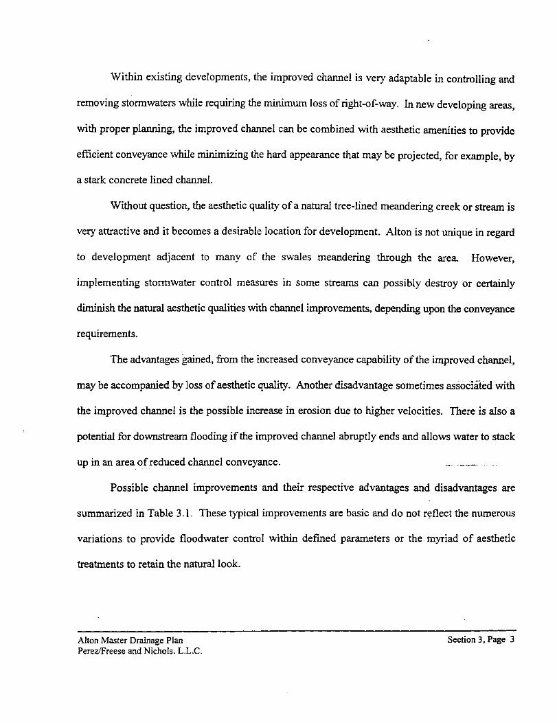
Within existing developments, the improved channel is very adaptable in controlling and
removing stormwaters while requiring the minimum loss of right-of-way. In new developing areas,
with proper planning, the improved channel can be combined with aesthetic amenities to provide
efficient conveyance while minimizing the hard appearance that may be projected, for example, by
a stark concrete lined channel.
Without question, the aesthetic quality of a natural tree-lined meandering creek or stream is
very attractive and it becomes a desirable location for development. Alton is not unique in regard
to development adjacent to many of the swales meandering through the area. However,
implementing stormwater control measures in some streams can possibly destroy or certainly
diminish the natural aesthetic qualities with channel improvements, depending upon the conveyance
requirements.
The advantages gained, from the increased conveyance capability of the improved channel,
may be accompanied by loss of aesthetic quality. Another disadvantage sometimes associated with
the improved channel is the possible increase in erosion due to higher velocities. There is also a
potential for downstream flooding if the improved channel abruptly ends and allows water to stack
up in an area of reduced channel conveyance.
Possible channel improvements and their respective advantages and disadvantages are
summarized in Table 3.1. These typical improvements are basic and do not r~flect the numerous
variations to provide floodwater control within defined parameters or the myriad of aesthetic
treatments to retain the natural look.
Alton Master Drainage Plan Perez/Freese and Nichols. L.L.C.
Section 3, Page 3
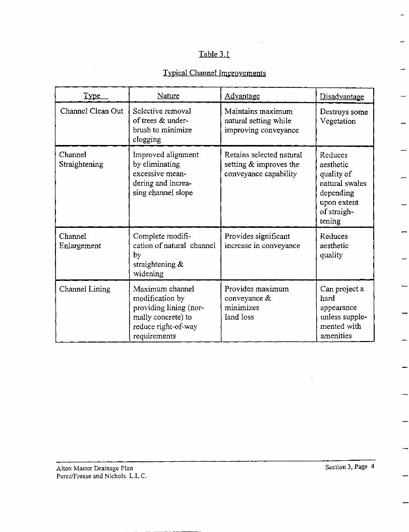
Table 3.1
Typical Channel Improvements
Type Nature
Channel Clean Out Selective removal of trees & under-brush to minimize clogging
Channel Improved alignment Straightening by eliminating
excessive mean-dering and increa-sing channel slope
Channel Complete modifi-Enlargement cation of natural channel
by straightening & widening
Channel Lining Maximum channel modification by providing lining (nor-mally concrete) to reduce right-of-way requirements
Alton Master Drainage Plan Perez/Freese and Nichols. L.L.C.
Advantage
Maintains maximum natural setting while improving conveyance
Retains selected natural setting & improves the conveyance capability
Provides significant increase in conveyance
Provides maximum conveyance & minimizes land loss
Disadvantage
Destroys some Vegetation
Reduces aesthetic quality of natural swales depending upon extent of straigh-tening
Reduces aesthetic quality
Can project a hard appearance unless supple-mented with amenities
Section 3, Page 4

Storage Oriented Approach: This method of storm water management provides for the
control by means of storing water and releasing it at a predetermined rate which can be adequately
conveyed by the downstream system. Traditionally, this method has been utilized on large streams
and river systems to control major flooding and is an important function of many of the large dams
existing on streams and rivers throughout Texas and the United States. In urban areas, detention is
being used to limit discharges from developed properties to that of the pre-developed conditions.
This is a requirement of Hidalgo County Drainage District No. I.
The general application of this methodology for watershed management on smaller areas has
seen increased use in recent years. Applications of this method are now employed to areas as small
as two acres and can even be applied to individual lots. The only requirement to affect this concept,
whether large or small, is provision of a storage area for stormwater collection. This
storage can be done on roof tops, parking areas, small ponds, or large areas requiring detailed
evaluation of the storage area and overflow spillway.
The storage concept may be divided into retention or detention facilities. The retention
storage method assumes the continual retainage of a given quantity of water that may be used for
aesthetic, recreational or domestic purposes. The retention system, however, has the capacity to
retain additional volumes of water for a short duration to reduce the maximum floodwater flow rate.
The stored stormwater is released downstream as rapidly as the receiving channe!s, creeks, or system
will allow, consistent with a storm water management program.
Alton Master Drainage Plan Perez!Freese and Nichols. L.L.C.
Section 3, Page 5
The detention storage method is similar to the retention system except no provision is made
for continuous storage of water. Rather, the stored floodwaters are completely released in a time
period consistent with a flow rate that will minimize or eliminate downstream flooding. Detention
storage has as its major function the control of stormwaters, yet this requirement may be utilized on
an infrequent basis. As a result, the detention storage area can very effectively provide multiple uses
for such functions as park areas, playgrounds, or athletic fields.
The primary function of the retention/detention concept is elimination or reduction of
downstream flooding by storing and controlling the released water. The prime advantage of this
concept is the use of smaller conveyance systems downstream. Depending upon the available
storage capacity, it may be possible for the natural creek or stream to convey the released waters and
not cause flooding. This approach not only can reduce the capital cost for larger downstream
facilities, but maximizes preservation of the aesthetic qualities of the natural stream area.
Multiple use of the storage area is also an advantage. New planning concepts generally
encourage open space, parks, and other recreation areas within a development. The
retention/detention areas are ideal locations for development of water-related aesthetic or recreational
facilities, or can be used for maintained green belts, parks, or athletic fields, depending upon the
storage area size.
An advantage associated with the retention/detention concept that ha_s recently received
considerable attention is the attenuation of stream pollutants. Inherent in the storage concept is rapid
reduction of water velocity which allows the precipitation of water-conveyed sediments and other
pollutants such as heavy metals, pesticides, and phosphorous, and thereby significantly reduces
Alton Master Drainage Plan Perez/Freese and Nichols. L.L.C.
Section 3, Page 6
downstream pollution. Because urban stormwater has been observed as a major contributor to
pollution of surface waters, the storage concept can be a very effective quality control facility. The
periodic disposal of collected pollutants is another factor that should be considered in the planning
of this type of facility.
Depending upon the upstream drainage area and the desired reduction of peak discharge, the
loss of developable land can become significant. For this reason the application of the storage
concept is generally restricted to new development that can incorporate the required storage area into
desirable open space, park, or recreational areas. In existing developments, the open space
requirements are generally prohibitive and the storage concept becomes difficult to apply.
The basic premise of the retention/detention concept is containment and storage of large
inflow rates and the gradual release of smaller outflow rates to the downstream area. Due to this
differential between inflow and outflow rates, extended period of time is needed to release the stored
volume of water. If the downstream conveyance system is inadequate and the peak flow reduction
provided by the retention/detention system is limited, it is possible to extend a reduced flood stage
problem over a longer period of time as opposed to the natural condition of higher stages of flooding
for a shorter period of time. It is important in selection and design of retention/detention facilities
to give adequate consideration to the downstream conveyance capabilities.
Construction of retention/detention facilities requires open land areas primarily in the upper
regions of a watershed. In the case of Alton, this is also true where a drainage course exits the study
area or where a drainage course enters the Hidalgo Drainage District No. 1 facilities. Desirable sites
will be those where existing depressions or abandoned caliche pits already exist, and the length of
Alton Master Drainage Plan Perez!Freese and Nichols. L.L.C.
Section 3, Page 7
dam construction will be minimal and sufficient capacity exists. Since the study area is relatively
flat, it may be necessary to excavate a storage area with a controlled overflow from the stream. The
stored water would later be released downstream through a conduit with a flap gates as the water
surface of the stream declines. Lack of property containing sufficient capacity within the watershed
management program area may make this concept only viable in select areas without excavation.
A comparison of the two structural methods of watershed management, conveyance systems
and retention/detention systems, is provided in Table 3.2. The conveyance and storage concepts are
the current state-of-the art structural methods for stormwater management control. Either approach
can be employed individually, but the best results will generally be achieved through a combination
of the two concepts. The integrated system of improvements should consider each drainage basin
as a whole to provide effective stormwater management control.
Federal Programs: Federal support for urban runoff control has been minimal, and limited
primarily to program planning and research. The Section 208 program under the 1972
Clean Water Act (Public Law 92-500) invested heavily in evaluations of water quality programs
resulting from urban runoff (3). The Soil Conservation Service (SCS) has historically gives
technical assistance to local governments to control soil loss and provide water resource management
in urban and rural areas. The types of controls the SCS has promoted reduce erosion/sediment, flow,
and flooding problems. These controls often have another benefit, stormwater pollution control (8).
The federal government has otherwise steered clear of urban runoff.
Alton Master Drainage Plan Perez/Freese and Nichols. L.L.C.
Section 3, Page 8
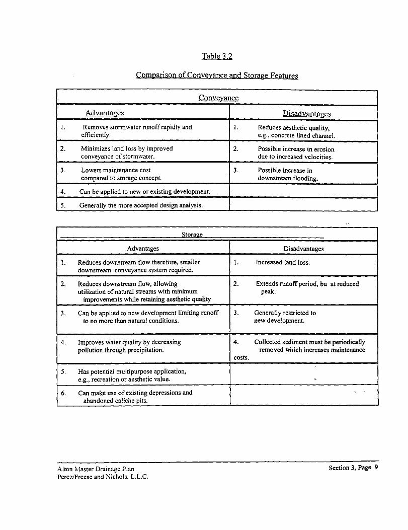
Table 3.2
Comparison of Conveyance and Storage Features
(;Qnveyan!;;e
Advantages
I. Removes stonnwater runoff rapidly and efficiently.
2. Minimizes land loss by improved conveyance of stonnwater.
3. Lowers maintenance cost compared to storage concept.
4. Can be applied to new or existing development.
5. Generally the more accepted design analysis.
Stora!!._e
Advantages
I. Reduces downstream flow therefore, smaller downstream conveyance system required.
2. Reduces downstream flow, allowing utilization of natural streams with minimum
improvements while retaining aesthetic quality
' Can be applied to new development limiting runoff .J.
to no more than natural conditions.
4. Improves water quality by decreasing pollution through precipitation.
5. Has potential multipurpose application, e.g., recreation or aesthetic value.
6. Can make use of existing depressions and abandoned caliche pits.
Alton Master Drainage Plan Perez/Freese and Nichols. L.L.C.
I.
2.
3.
I.
2.
3.
4.
costs.
Disadvantage:~
Reduces aesthetic quality, e.g., concrete lined channel.
Possible increase in erosion due to increased velocities.
Possible increase in downstream flooding.
Disadvantages
Increased land loss.
Extends runoff period, bu at reduced peal<.
Generally restricted to new development.
Collected sediment must be periodically removed which increases maintenance
-~
Section 3, Page 9
Texas Legislation Related to Floodwater Management: Municipal floodwater
management controls are authorized by Article 8280-13 ofthe Revised Civil Statutes of the State
of Texas, commonly known as the "Flood Control and Insurance Act." The primary purpose of this
Act is the "promotion of public interest by providing appropriate protection against the perils of
flood losses and encouraging sound land use by minimizing exposure of property to flood losses."
Subsection (5) of Section 5 provides for the development of a flood plain management program and
the adoption and enforcement of permanent land use and control measures to aid in the
implementation of the program.
Home Rule Authority: Any assessment of the legal considerations and requirements
involved in providing an appropriate stormwater management program should include both the
program functions and the financing options to properly balance the needs of the community with
the authority and resources available to the City. A home rule city has a good deal offlexiblilty in
organizing and financing municipal programs to meet the community's needs. The analysis of
finance options addresses several innovative financing methods many of which have not previously
been widely used. These include establishing drainage as a utility and using impact or capital
recovery fees.
The State of Texas has not specifically authorized cities to use the full range of possible
drainage financing methods. It is fortunate that a home rule city has some latituqe in using a variety
of financing concepts. Home rule cities look to state law for limitations upon their powers, not for
specific grants of power. Thus, home rule authority enables the City Council to enact funding
methods which respond to the City's drainage needs without specific authorization at the state level.
Alton Master Drainage Plan Perez!Freese and Nichols. L.L.C.
Section 3, Page 10
However, restrictive court definitions oflocal taxing powers in Texas could impose limits on a city's
flexibility.
From a practical standpoint, the program and financing strategy proposed for stormwater
management must reflect the needs and attitudes in the local community and must be attractive to
promote orderly growth. The options identified throughout this report have been developed in a
manner that is intended to be consistent with reasonable public policies. The public will better
understand drainage issues and the rationale underlying the strategies if the alternatives are clearly
in tune with City policies on economic development, neighborhood revitalization, and environmental
protection. Existing policies should not, however, foreclose opportunities to introduce new
financing concepts or adjust existing policies.
3.3 Nonstructual Alternatives
Governmental Controls: Local governmental or administrative controls are means of
providing control to sensitive areas such as the watershed and its flood plain. Such controls
significantly broaden the scope of watershed management beyond the normal structural controls.
Governmental controls take two forms: regulatory and non-regulatory.
Zoning and subdivision regulations are effective regulatory control tools in ~ormwater
management. New approaches to the control and management of land allow flexibility in the
operation of flood plain land use controls.
The detailed specifications commonly found in zoning ordinances are gener8.llfiriadequate
when applied uniformly over an entire flood plain zone. The natural functions of the flood plain vary
from site to site (1) due to local conditions, (2) how the site interacts with the surrounding natural
Alton Master Drainage Plan Perez/Freese and Nichols. L.L.C.
Section 3, Page II

features, (3) which conditions have a direct impact upon the site, and ( 4) whether the site is relatively
pristine or is in the process of adjusting to surrounding disturbances.
An approach, that of controlling the impact of uses, represents a shift from zoning control
of uses. Because of the shift in focus, this approach has caused some major changes in the operation
of flood plain land use controls. This change can be characterized by a movement away from
detailed specifications concerning construction techniques or site requirements and a movement
toward performance criteria for land use.
One of the most commonly used methods of establishing performance type controls is the
development of a series of policy guidelines that outline the community's expectations on the
function of the land. The ensuing regulations are individualized, with each case being judged on its
own merits as to how well it satisfies the policy guidelines. An alternate to this method is the use
of performance standards. Using this type method, the community sets a specific measurable level
at which the key functions of a development will meet these standards.
Subdivision control regulations are effective tools in watershed management. Unlike zoning
ordinances which apply only within the city limits, subdivision control in Texas extends to areas
within a city's extraterritorial jurisdiction (ETJ).
An effective method used in the establishment of a storm water management program is the
incorporation of runoff, erosion, water quality, and sedimentation controls into th~ City's subdivision
ordinance performance specifications and design standards. This system allows for uniform
application of a stormwater management program throughout the watershed, minimizing the
possibility of inter-ordinance conflicts.
Alton Master Drainage Plan Perez/Freese and Nichols. L.L.C.
Section 3, Page 12
Non-regulatory controls take several forms. Annexation of areas which could potentially
affect the flooding characteristics of the community is a viable method of increasing the
effectiveness of stormwater regulatory controls. As discussed in the previous section, the
subdivision ordinance and its platting requirements are essentially the only formal control the City
has in regulating development in the ETJ. By annexing land, the City can use additional regulatory
tools including the zoning ordinance, building code and the site plan review process.
Direct ownership through a fee simple purchase is one of the most effective means of
preserving flood plains as open space areas, parks, existing caliche pits, or nature reserves within the
City's corporate limits. Because of the direct expenditure of funds, there are fiscal limitations to this
approach. However, some grant and loan programs are available to local governments through
various public and private agencies for preservation and open space development within the City's
corporate limits.
Purchase and/or dedication of flood easements is another option available for the control of
flood hazard areas. This technique is usually implemented along drainageways requiring regular
maintenance and inspection so as to maximize accessibility.
The development of governmental policies that limit or discourage the extension of public
services (i.e., roads, utilities, parks, etc.) into a flood prone areas are effective tools in the promotion
of stormwater management. By not authorizing the extension of services_ to nonconforming
developments, the City in conjunction with private utility companies, can encourage flood conscious
design.
Alton Master Drainage Plan Perez!Freese and Nichols. L.L.C.
Section 3, Page 13
Municipal Drainage Regulations: The Alton's Zoning Ordinance, Subdivision
Regulations, and Building Code are the primary instruments used in the reduction of flood hazards
within the city and its extraterritorial jurisdiction.
Drainage regulations to be developed for Alton should be designed to provide a stable
foundation for a stormwater management program and provide effective measures for the prevention
of flood damage to development. The regulations should outline concise performance standards for
development outside of the flood hazard areas. Outlining at least a minimum level of performance
for runoff will mitigate the long-term impact of development throughout the watersheds.
Alton Master Drainage Plan PereziFreese and Nichols. L.L.C.
Section 3, Page 14

4.0 Stormwater Management Costs
Once the scope of storm water management activities has been defmed, it is necessary to
estimate the annual cost for programs to achieve the stated program goals. Estimating the total costs
(i.e., revenue requirements) of a comprehensive stormwater management program is the first step
in preparation of a fmancing plan. Costs for each specific function performed as part of the program
(e.g., capital improvements, operations and maintenance) must be estimated.
For initial studies, such as this one intended to present various management practices, order-
of-magnitude estimates are sufficient to obtain a concept of the total cost of such a program. For
implementation, more detailed analyses-- preferably in the context of a specific master storm water
development plan--are warranted.
Recently published literature provides a range of estimates of costs for stormwater
management. In most cities, basic annual watershed administration, engineering, and reactive
maintenance cost $30 to $50 per acre. Comprehensive management, including drainage master
plans, preventive maintenance, and major capital improvements will cost several thousand dollars
per acre.
This section presents representative data on the cost of each aspect of stormwater
management: administration; planning, design, and engineering; regulation and enforcement;
operations and maintenance; and capital improvements.
4.1 Administration
Administrative costs for watershed management are difficult to estimate. In situations where
Alton Master Drainage Plan Perez/Freese and Nichols, L.L.C.
Section 4, Page 1
no separate drainage division exists, estimating administrative costs from historical records will
involve, for example, determining the percentage of time devoted to storm water management by
various personnel in Public Work, Planning, Code Enforcement, and other departments.
In most cases, the assumption that administrative expenses will be a certain percentage of
total capital costs is a reasonable approach. The formation of a stormwater management utility will
significantly increase administrative costs, however, because of the costs of developing and
administering a billing system. Therefore, the percentage of total costs for administration most likely
will be higher under a utility approach.
4.2 Planning, Design, and Engineering
Costs for planning, design, and engineering may be determined separately or may be included
with other functions such as capital improvements, maintenance, and plan review (regulation). In
cities where separate engineering divisions exist, estimates of the costs can be prepared by totaling
the historical cost of personnel and adding an overhead percentage.
4.3 Regulation and Enforcement
Many jurisdictions charge fees based on actual cost of service for plan review, inspections,
and other regulatory services. Therefore, compared to other costs, the costs_ for regulation and
enforcement can be determined relatively easily and fairly accurately. However, to the extent these
costs are fmanced by fees, they should not be added to the estimate of cost for function that will be
financed by some other method.
Alton Master Drainage Plan Perez/Freese and Nichols, L.L.C.
Section 4, Page 2
4.4 Operation and Maintenance
The difficulties in estimating operations and maintenance (O&M) costs are similar to those
in estimating costs for administration. To determine stormwater management costs, most public
work's maintenance supervisors have to estimate the percentage of time that various people spend
on stormwater maintenance as opposed to maintenance of other infrastructure. This division is
difficult to do accurately.
Another approach is to estimate O&M costs as a percentage of total capital investment This
is relatively straightforward for recently built or proposed facilities; it is not as helpful for older
facilities that need substantial maintenance. For recently built or proposed facilities, 3% to 5% of
the base construction cost should be allocated for maintenance
A third approach, which presumes knowledge of the location and condition of all facilities,
is to assign unit costs for maintenance to each facility that will be maintained. This approach is
likely to be possible only in situations where inventories of facilities recently have been completed
or where master plans recently have been prepared. Table 4.1 shows representative costs for
mowing, debris removal, and other routine activities.
Alton Master Drainage Plan Perez/Freese and Nichols, L.L.C.
Section 4, Page 3
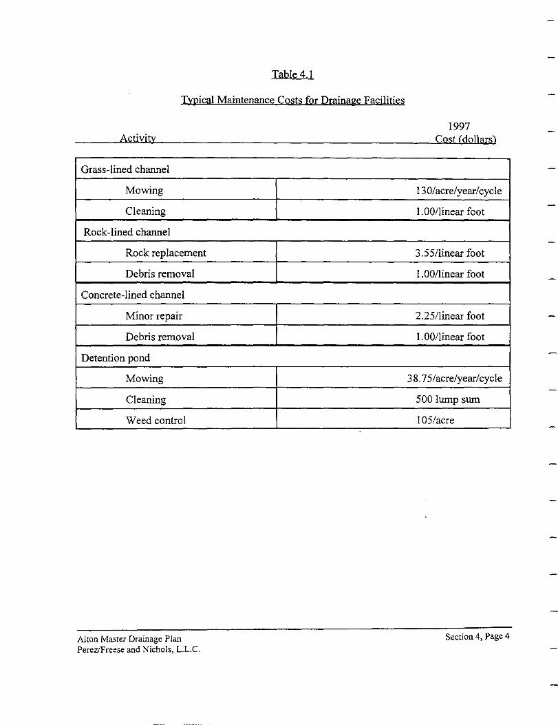
Table 4.1
Typical Maintenance Costs for Drainage Facilities
Activity
Grass-lined channel
Mowing
Cleaning
Rock-lined channel
Rock replacement
Debris removal
Concrete-lined channel
Minor repair
Debris removal
Detention pond
Mowing
Cleaning
Weed control
Alton Master Drainage Plan Perez!Freese and Nichols, L.L.C.
1997 Cost (dollars)
130/acre/year/cycle
1. 00/linear foot
3.55/linear foot
1.00/linear foot
2.25/linear foot
1.00/linear foot
3 8. 75/acre/year/cycle
500 lump sum
1 05/acre
Section 4, Page 4
4.5 Capital Improvements
Capital costs can be estimated for master drainage plans, capital improvement
budgets, or other similar sources. One method for estimating is the use of tabulations for previous
projects. These tabulations can be used as a guide, but no assurances can be drawn involving similar
applications, especially if the severity of the conditions varies between the applications.
A second method is the use of old master drainage plans, capital improvement budgets, and
engineering publications to supplement bid tabulations. However, these figures are only as accurate
as the quantity of materials estimated.
A third method is the use of published equations for estimating construction costs. These
equations may be useful in situations where a capital cost estimate of facilities is needed to estimate
maintenance costs, and no other method is available. For example, if an estimate of maintenance
costs is needed for an old facility for which no construction costs are available, these equations could
be used to estimate current construction costs, and then calculate maintenance costs from that
estimate. Also, these equations can be used for rough replacements costs of new facilities that have
failed. This method should be utilized only when the first and second estimating methods cannot
be used.
4.6 Summation
Establishing a concept for the storm water management program is a critical first step in the
preparation of a financing plan. Costs for each specific function performed as part of the program
must be analyzed with respect to the program concept to determine total costs for comprehensive
Alton Master Drainage Plan Pere:z/Freese and Nichols, L.L.C.
Section 4, Page 5
storm water management. Adequate funds for maintenance as well as capital improvements must
be available for an effective watershed management program.
The Watershed Management Program must generate sufficient funds to provide for maintenance of
existing and future stormwater structures, personnel costs, annual capital improvement projects and
administrative expenses.
Alton Master Drainage Plan Perez!Freese and Nkhols, L.L.C.
Section 4, Page 6

5.0 Financing Options
The lack of stable and adequate local fmancing is a major obstacle to implementation of
comprehensive, long-range stormwater management programs. Traditional municipal financing
methods have proven to be ill-suited to funding major improvements to drainage systems, their
maintenance and operation, and regulation of private sector activities which impact the systems.
This section addresses major recent changes in watershed management financing, and describes
some of the alternative and innovative approaches which can be considered. It briefly summarizes
a range of financing concepts and suggests criteria for evaluating various financing alternatives.
The range offmancing option concepts available to the City of Alton includes those which
are explicitly authorized by state legislation. those available under home rule authority, and methods
which might require legislative authorization at the state level. Each of the options identified in this
section has been used in one or more cities in the United States, though some have not been
implemented in Texas. Their use in Alton could be subjected to legal challenge and judicial
interpretation. Financing concepts used in other states cannot be assumed to be legal under Texas
law, and methods held to be invalid in other applications should not necessarily be considered
invalid for stormwater management.
Since both legislative and judicial actions may limit the application of the various methods
of drainage financing, this list of options will require legal review by the City Attorney's Office. No
legal evaluation was made during this analysis.
Alton Master Drainage Plan Perez!Freese and Nichols, L.L.C.
Section 5, Page 1
5.1 Summary of Financing Options
Traditionally, stormwater management has been financed using general fund revenues for
annual operating expenses and a mix of revenue sources for capital improvements. The level of
operational funding in most jurisdictions has only been sufficient to respond to the highest priority
needs, and has not allowed comprehensive programs to be developed.
The range offmancing option concepts presented herein is a contrast to the limited number
of funding sources that have been used for stormwater management in the past. The options should
be viewed as opportunities to broaden the base of support and balance financial participation in a
stormwater management program, while also localizing costs when it is more appropriate than
distributing them citywide
5.2 General Fund
The general fund of the City is the "base" of fmancing for municipal programs, with revenues
from a number of sources including property taxes, excise and sales taxes, business licenses and
taxes, utility taxes, and fees of several types. It supports wholly or partially those city functions
which do not have other sources of funding such as service charges.
The City administration and Board of Alderman have discretionary control of the general
fund through the budget process. Identified municipal responsibilities and political realities tend to
defme how most of these revenues are spent, however. It has historically been difficult for programs
which focus on long-term, capital intensive, public facilities construction and maintenance to
complete effectively in an annual municipal budget process.
Alton Master Drainage Plan Perez!Freese and Nichols, L.L.C.
Section 5, Page 2
There are few explicit limitations on the use of general fund revenues. They can be spent on
both operational and capital expenses, although most often they are used for annual operating costs.
Capital outlays· which are sometimes paid from the general fund include equipment and land
acquisition, but only rarely major construction.
General fund revenues are often relatively susceptible to economic conditions in the
community. Sales tax and excise tax receipts drop during a bad economic slump. Property values
may decline leading to reduced tax assessments. Property tax delinquencies tend to increase during
periods of recession and high interest rates. At the same time demand for many municipal services
(especially police and social services) increases.
Insofar as drainage is concerned, fmancing through the general fund tends to create an
imbalance of costs in comparison to contribution to drainage problems, benefit or services received.
The complexity of drainage problems makes it difficult to accurately define who pays a
disproportionate amount or receives more in benefit than they may be paying. It is clear, however,
that there is no measurable basis of equity inherent in general fund financing of stormwater
management.
5.3 Drainage Utility Service Charges
This fmancing method has been instituted in a number of cities and coun~ies (particularly in
the western U.S.) as an alternative to general fund financing for annual operating expenses. These
"user" charges are analogous to water and sanitary sewer service charges, but dedicated for
stormwater management. This approach requires that an enterprise fund utility be established for
Alton Master Drainage Plan Perez/Freese and Nichols, L.L.C.
Section 5, Page 3

stormwater management.
The drainage utility is an innovative concept, but one which fits uniquely well with the
program needs in most local stormwater management operations. The functions and costs for
effectively managing drainage are similar to those needed to provide water supply and sanitary sewer
programs. Since water and sewer have been financed through service charges for some time, it is
not swprising that drainage utilities and service charges have been implemented in the same basic
format.
The philosophy behind user charges for watershed management differs from those for water
and sewer service in several ways. Unlike water supply, a measurable commodity is not delivered
to the customer. The service provided is similar to sanitary sewers or solid waste disposal in that
something is carried away and disposed of (i.e., stormwater) but quantified measurement is difficult
and costly. The demand for the "service" is not comparable to the demand for water supply, since
most properties drain onto downhill neighbors fairly effectively without any public system. A
broader definition of benefit resulting from service is needed in the case of drainage than for other
utilities. Finally, drainage programs are more oriented to solving or mitigating problems than are
the other utility functions, which have focused on providing service to clients.
Unlike some of the other financing options, user charges can provide a true alternative to
general fund financing for drainage, rather than just a supplement to it. The o_ther options have a
limited clientele group and will not generate sufficient revenue to fund all the necessary functions.
User charges, on the other hand, spread the expense of the drainage program as broadly as possible
throughout a community, resulting in a relatively low cost for each property owner.
Alton Master Drainage Plan Perez!Freese and Nichols, L.L.C.
Section 5, Page 4
Revenues derived from service charges can be used to pay for administration, planning,
design, operations and maintenance, revenue bonds for new construction and replacement of old
systems, support services, regulatory functions, and virtually anything else required in a drainage
program. Rate structures are flexible mechanisms which enable a city to tailor the cost distribution
to fit the local program and be consistent with other local policies. Finally, drainage utility revenues
remain in the utility fund if not spent, rather than reverting for redistribution in the next year's
budget, an important factor in long-term program stability.
5.4 Interfund Loans to Drainage Utility
The legislative action establishing an enterprise utility necessarily precedes the imposition
of service charges and collection of revenues. An interfund loan from another municipal fund(s)
may be desirable for interim financing of stormwater management functions until revenues are
generated by the drainage utility. An interfund loan of this type is normally repaid from the utility
service charge revenues.
5.5 General Obligation Bonding Repaid by Property Taxes
Capital improvements are often too expensive to finance from operating revenues, especially
when an activity is funded from the general fund. General obligation bonding is a form of municipal
borrowing in which the full credit of the city is pledged to service the bond debt. These bonds
require voter approval, and usually involve an excess property tax levy. They have been used for
many purposes in the past, though use of them for utility projects has diminished with greater
Alton Master Drainage Plan Perez/Freese and Nichols, L.L.C.
Section 5, Page 5
acceptance of revenue bonds.
Because they are backed by the full credit of the local government, general obligation bonds
normally receive the most attractive (lowest) interest rates of any municipal borrowing instrument.
They can be issued with varying maturities and other provisions which may affect their marketability
and the interest rate they must pay.
5.6 Revenue Bonding Repaid by Service Charge Revenues
Enterprise funds, such as utilities, which have a source of fmancing separate from the general
fund can borrow money for capital improvements through bonds to be paid off with service charge
revenues. These bonds do not require a voted approval, but are usually subject to slightly higher
interest rates than general obligation bonds because the full credit of the city is not pledged.
Revenue bonds do not authorize an increase in taxes, nor do they usually authorize a specific
increase in utility service charges. If necessary to support the bonds, a rate increase is normally
enacted separately. It is possible to use service charge revenues from throughout a service area to
repay revenue bonds or to specify that only revenues from one area or even certain properties be used
for the bond payments. In most cases, it is best to place few limitations within the bond ordinance
which relate to revenue sources, while still being consistent with financing philosophies and local
policies. This provides the bondholders with some assurance of payment, and may result in a lower
interest rate.
Although typically the bonds are repaid from the regular service charge revenues,
municipalities may also establish system development charges, hook up fees, and other financing
Alton Master Drainage Plan Perez!Freese and Nichols, L.L.C.
Section 5, Page 6

methods and earmark those funds for repayment of the revenue bonds. This reduces the revenue
required from the standard service charge by the amount generated by the special fees and charges,
and ensures that developing properties help pay for the project.
5.7 Utility Tax Revenues
Utility taxes and franchise taxes are levied on utilities operating with a municipality,
including one or more of the following in most jurisdictions: telephone, electricity, natural gas,
water, sewer, solid waste, fuel oil, cable television, and drainage. In recent years, cities have used
utility tax revenues to construct various kinds of capital improvements, including drainage system
improvements. In general, communities have a high level of discretionary control of utility taxes and
their uses.
5.8 Tax Increment Financing
Tax increment financing can be used to provide funds for an infrastructure in areas where
development is desired but funding for public facilities are not otherwise available when needed.
In this approach, increases in tax revenues that are realized as a result of new development in a
specified area are earmarked for fmancing public improvements or services in that area.
Usually administered by a public agency, a district is defmed with a spec~fied "base line" tax
base of existing development. Improvements within the area are financed from the general fund or
from bonds, then repaid from increasing tax revenues generated by the new development. The new
development in effect pays its own way, using the community's normal tax program as the
Alton Master Drainage Plan Perez/Freese and Nichols, L.L.C.
Section 5, Page 7

mechanism for deriving revenues. The method does have the drawback of siphoning off all increases
in revenues, even revenues attributable to increased value of existing development in the area, until
the bonds are paid off.
5.9 State Funding
Community Development Block Grant Funds: These revenue sharing funds are intended
for use in neighborhoods which have been targeted for improvement based on social-economic and
physical condition criteria. The City has discretion in the use of the funds within broad guidelines.
In Texas, CDBG funds are administered by the Texas Department of Commerce.
With pressures to balance the federal budget, the future of federal development funding is
uncertain and the City should not depend on CDBG funds. In addition to the uncertainty surrounding
revenue sharing funds, the program itself has substantially more applicants that funds available.
Therefore, grants are generally awarded to those communities with highest priority needs, such as
substandard housing, inadequate water and sewer systems, and a significant percentage of
low/moderate income residents.
Texas Water Development Board Funding: The Texas Water Development Board
(TWDB) administers state funds for fmancing flood control projects. TWDB funds are disbursed
to eligible political entities, generally as loans. Using the state's excellent bond rating, TWDB sells
Texas Water Development Bonds which are general obligations of the state and purchases the bonds
of local political subdivisions.
Historically, use of the Texas Water Development Fund was reserved for "hardship" political
Alton Master Drainage Plan Perez/Freese and Nichols, L.L.C.
Section 5, Page 8

entities (political subdivisions unable to sell bonds in the open market or political subdivisions
unable to sell bonds at a reasonable interest rate). However, passage of House Bill2 by the 69th
Legislature and approval by voters in November 1985 expanded the program to allow TWDB to
make loans without a finding of hardship for the construction of a regional water treatment facility,
flood control project, and facilities designed for conversion from the use of ground water to surface
water.
TWDB may provide loans from flood control funds for the following flood-control related
projects: (1) construction of storm water retention basins, (2) enlargement of stream channels, (3)
modification or reconstruction of bridges, ( 4) the acquisition of floodplain land for use as a public
open space, (5) acquisition and removal of buildings located in a floodplain, (6) relocation of
residents of buildings removed from a floodplain, and (7) development of flood plain management
plans. To determine if a project is eligible for loan funds, several points are considered including the
needs and benefits of the project to the area to be served, the availability of revenue for repayment
of the loan, and whether the political subdivision can reasonably finance the project without State
assistance (hardship).
5.10 Fees and Charges
Cities have developed a variety of special administrative fees and charges to cover expenses
which are associated with permits and other services for individuals. In most cases an identifiable
"client" is assessed the fee or special charge, which is often earmarked to support a specific function.
Alton Master Drainage Plan Perez!Freese and Nichols, L.L.C.
Section 5, Page 9

Plan Review and Inspection Fees: The City has specific design and construction standards
which private drainage systems must meet. Development permits are issued only when the plans
meet these standards, requiring that the staff check that plans. Field inspections are necessary to
verify that the systems are installed as designed, since private drainage systems may have a direct
impact on the function of public systems. Some cities attempt to make plan review and inspection
financially self-sufficient through the fees, while others subsidized these functions partially out of
general fund revenues to encourage development. The net effect of this type of fee is to have
individuals with changes in land use bear some or all of the cost for improvement of public services
impacted by their projects.
On-site Detention/Retention System Inspection Fees: The private drainage systems which
are installed on private property are important components of the total drainage system. Public
systems are often designed and operated on the assumption that the private systems will function
properly. Experience has shown, however, that voluntary maintenance of private drainage systems
is very lax. Annual inspections of private on-site facilities can identify needed maintenance before
problems occur, but they are relatively expensive to carry out on a regular basis. These inspections
can be billed to the property owner as a service charge if a drainage utility is established. It may be
possible for the City to also levy such a charge without a utility, though an annual permit of some
type may be needed.
Impact Fees: Impact fees are charges or assessments against new development to fund the
cost of capital improvements or facility expansions necessitated by and attributable to the new
development. As of June 1987, Texas cities are expressly authorized to assess impact fees for
Alton Master Drainage Plan Perez/Freese and Nichols, L.L.C.
Section 5, Page I 0
drainage facilities provided that the fees are directly associated with actual impacts and earmarked
to ensure they are used to mitigate those effects. Further, the costs of over sizing facilities
constructed prior to adoption of an impact fee ordinance may be recouped through the fees.
Impact fees began as a response to the realization that construction and land development
may have significant impacts on a neighborhood or even an entire community. Rapid growth
fostered a concern not only for the environmental effects of growth, but the economic implications
as well. Increased urban runoff and pollution, congested highways, and larger water and sewer
facilities often translate into higher property taxes to upgrade municipal systems in response to
problems. Impact fees are perceived as a mechanism to make growth pay it's own way by
participating in the cost of new facilities at the front end of a project rather than indirectly through
long-term enhancement of the tax base and increased local employment.
While the recently enacted state legislation limits the use of the impact fee concept, the
statute validates a funding process that has already passed judicial scrutiny. The new law requires
that, prior to adoption of an ordinance establishing impact fees, a City must conduct several studies
to determine the real impact of new development on the infrastructure. These studies include land
use asswnptions, establishment of service areas, a capital improvements plan, and analyses relating
the costs of improvements to individual "service units." The statute also prescribes a definitive
adoption procedure and requirements for earmarking and accounting, refunds, _and assessment and
collection of the fees. Prohibitions on the use of fees include "repair, operation or maintenance of
existing or new capital improvements" and "administrative and operating costs" of the City.
Impact fees are sometimes confused with the other types of special fees and charges cited in
Alton Master Drainage Plan Perez!Freese and Nichols, L.L.C.
---------------·----···----
Section 5, Page I I
this report. Care should be taken to differentiate between impact fees, which are associated
specifically with the impact of a project, and the general needs for new facilities to serve the
community.
Development Assessment Charges: As an alternative to requiring each new development
to provide conveyance systems, on-site detention or retention to mitigate increases in peak runoff,
the City could institute this type of charge as an option available to developers in some drainage
basins. Detention capacity and conveyance systems would be satisfied by regional public facilities,
which the developers would be "buying into" through the development assessment charge instead
of building the on-site detention system. Such fees are then earmarked to pay for regional detention
facilities.
This approach will probably be enthusiastically welcomed in communities where developers
have experience with building their own on-site detention systems. Not only are the developers
relieved of the cost of design and responsibility of building the on-site facility, but they gain more
flexibility in the use of their property since an area need not be set aside for detention of storm water.
Assessment fees are particularly useful when more than one type of drainage system would
solve or mitigate a problem, but one approach would be privately fmanced while the other would be
paid for from public funds. In some cases, the cities would prefer to have the type of system that
would require public fmancing, yet do not want to forego the private investmen~ which is justified.
Assessment charges can offer the best of both options by allowing the most desirable system to be
built while still ensuring private financial involvement.
System Development Charges (SDCs): These charges have been used by municipal utilities
Alton Master Drainage Plan Perez!Freese and Nichols, L.L.C.
Section 5, Page 12
for a number of years as a method of financing improvements. They have been known by several
titles other than system development charges, e.g., utility expansion charges and extension and
improvement charges. System development charges differ from other similar charges, such as
general facility charges, in that they are associated with specific improvements are constructed as
a means of balancing fmancial participation.
Communities must frequently install suitable water, sewer, and drainage systems in
anticipation of growth. System development charges enable communities to meet the increasing
demands on systems which accompany growth pressures. The SDC resembles the latecomer fee for
developer extensions, which is explained below, in that the intent is to enable a community to
achieve excess capacity improvements in advance of growth. At the same time, place an equitable
portion of the cost on those properties which later develop and makes use of the extra capacity that
was built into the system.
When revenue bonds (supported by drainage utility service charges) are used to finance
drainage improvements, SDC's can ensure that all properties, adjacent to or within the watershed,
equitably participate in the financing of the capital improvements. Major drainage improvements
are normally sized with future development in mind and have a useful life at least two or three times
as long as the bond maturity. One purpose of the SDC's concept is to ensure that the properties
which develop after the bonds are sold also help to pay for the improvements, SDC's should be
consistent with that amount paid by developed properties when the improvements were constructed.
The SDC provides a rational financing method which responds to the sensitive issue of who
pays for over-sizing to accommodate future growth. Care must be taken, however not to place too
Alton Master Drainage Plan Perez/Freese and Nichols, L.L.C.
Section 5, Page 13
much confidence on future growth as a revenue source. If the growth slows or does not occur, the
existing developed properties might have to pay a larger service charge in the future to cover the
shortfall of SDC revenue. Unanticipated increases in service charges due to SDC shortfalls can
erode a utility's credibility with the public, and should be avoided through conservative projections.
General Facilities Charges: General facilities charges are similar to the SDC concept,
although they are more often used for overall improvement to a system, or for maintenance or
replacement than for specific capital improvements. This method of financing is most often used
when improvements which will benefit an entire service area are involved.
If a community has sufficient drainage utility service charge revenues that improvements
made to the drainage system can be paid for directly out of revenues rather than through bonding,
general facilities charges can be used to balance the financial participation. For example, if all
improvements to the drainage systems are oversized for future conditions but the developed
properties are not billed a service charge, the general facilities charge can be used to ensure that
developing properties "buy into" the prior capital investment in the system. This type of financing
works best when the newly developing properties must obtain a permit to hook up to the drainage
system, similar to the case of water and sewer.
The general facilities charge is probably most appropriate when a simplified rate structure
is used which lumps operating and capital expense into a uniform system of charges or an
"equivalent residential unit" approach. In such cases, the costs of all elements of the drainage
program are spread area-wide without a highly refined cost distribution formula.
The underlying philosophy of this approach is that the improvement serves everyone, or the
Alton Master Drainage Plan Perez/Freese and Nichols, L.L.C.
Section 5, Page 14

system is viewed as a fairly uniform whole rather than as a number of discrete parts. There is usually
no need to break down a general facilities charge into component parts, whereas a system
development charge is often associated specifically with revenue bonds for individual improvements,
which suggests that much closer accounting practices are justified.
Other terminology is used in different areas of the country for financing concepts quite
similar to general facilities charges. Water and sanitary sewer "hook up" fees are often intended to
help finance general improvements to the systems rather than simply cover the expenses related
directly to the hook up itself. Some cities include general facility charges in building permit fees,
or other municipal approvals associated with development. Regardless of what they are called,
general facilities charges for drainage provide an additional revenue source which may fill in gaps
in a utility rate structure. The gaps are often intentional and reflect the City's financing policies (e.g.,
undeveloped properties do not help fmance utility systems), or occur because of billing system
limitations.
Latecomer's Fees: These charges are especially useful in developing areas or where major
reconstruction or upgrading of a drainage system is needed, public funds are limited or not available,
and a private development is contingent on the improvement. Through a developer extension
agreement, the City can allow the developer to construct the improved and oversized drainage
facility in conjunction with the project.
Developer extensions are common for water and sewer systems in new developments, but
have not been widely used for drainage systems. The latecomer's fee is usually only used for over
sizing costs, for example in the case of sanitary sewer interceptors or to ensure fire flow capacity to
Alton Master Drainage Plan Perez!Freese and Nichols, L.L.C.
Section 5, Page 15

other properties. This charge method may be applied to drainage systems as well.
Regardless of what these various fees and charges may be called, they typically have
specified purposes, and are accounted for in a manner which allows the revenues to accumulate.
Fees and charges dedicated for specific purposes can be carried forward, and reserves can accumulate
if an enterprise utility fund is established for drainage which separates the revenues from the general
fund.
Revenue which is not spent for several years may also require special accounting
treatment in municipalities in some state. Usually, the money must be accounted for in the budget,
even if it is not intended to be spent during that year. For water, sewer, and solid waste, a utility
expansion fund is often the reserve account for these revenues in a municipal budget. Drainage
utilities can use the same accounting technique to make dedicated reserves less susceptible to
application to other needs, a protection which may be important in differentiating fees from taxes.
Utilities are allowed to retain surplus funds, both as a reserve to respond to emergencies and
as a natural function of long-term rate structures which are predicated on differing rates of change
in expenditures and revenues over time. This reduces the frequency at which the rate structure must
be changed, contributing to stability. Similar accounting practices allow revenue accounts for fees
and charges in a utility to accumulate. It is important to clearly identifY reserved funds in the annual
budget and to maintain a proper audit trail to ensure that an accurate pictpre is given of the
enterprise's balance sheet, including fee accounts.
5.11 Special Assessments
Alton Master Drainage Plan Perez/Freese and Nichols, L.L.C.
--------------------
Section 5, Page 16
Several methods of levying special assessments on benefited properties to pay for drainage
improvements have been used around the country. In most cases, the projects have a demonstrable
benefit to the properties included in the assessment area and the charges for each parcel are
consistent with the relative benefit to each property. In Texas, special assessment options include
drainage districts, which are special-purpose taxing districts with specific authority to deal with
stormwater management (1 0), and special improvement districts, which are areas of the city where
the majority of property owners have requested City Council to establish a district and collect
assessments to fund levels of service and programs in excess of the existing levels (11 ).
5.12 Criteria for Evaluating Financing Options
Whenever an effort is made to develop a new drainage program and/or a new financing
concept for a municipal function as complex as stormwater management, some basis must be
established for judging the appropriateness of the various options. A financing strategy must
provide a stable, adequate, and publicly acceptable source of funds which will support the entire
program as efficiently and equitably as possible. Transition, growth, and future program
requirements must be considered as well as immediate needs. Further, the fmancing strategy must
be consistent with the community's perceptions and resources.
Based on experiences in cities which have implemented stormwater management programs,
the following criteria were selected as qualitative measures of the financing options. It is unlikely
that any single financing method will be judged best under this wide range of considerations, but the
criteria should help identify the best mix of funding methods, and reconcile differences between
Alton Master Drainage Plan Perez/Freese and Nichols, L.L.C.
Section 5, Page 17

program and fmancing strategies. Some of the criteria may be viewed as more important than others.
The order does not imply a priority, although public acceptance based on perceived equity is
essential for political success of any new storm water financing proposal. No single criteria should
outweigh the others to the extent that an option is selected or rejected solely on one consideration.
Perceived Equity and Public Acceptance: Public acceptance of a financing strategy and
the mix of financing methods it incorporates is essential for a drainage program to be successful.
It must be recognized that some members of the community will not wish to pay anything, through
any financing method, to fund drainage control. In most cases, a larger segment of the population
will understand the need for an adequate stormwater management program, and the necessity of
paying for it. To these citizens the critical issue is usually equity. It is important to note that perfect
equity is probably not achievable either technically or economically, and that public opinion will be
based on "perceived equity" and an appearance of basic fairness in financing.
The key is to finance stormwater management in an understandable manner. This is the
strength of classifYing fmancing techniques according to purposes for which the technique typically
is used. It presents a logical association between what is done (functions) and how to pay for it
(financing). To achieve perceived equity and public acceptance this logic must be communicated
to the general public through various public information concepts.
Flexibility: A great deal of change could occur in stormwater managem~nt programs during
the next decade. More effective regulation and maintenance of systems could be required. Water
quality may become as important a concern in the overall management of the drainage systems as
flow control. A financing strategy should be responsive to the growth needs of the program and to
Alton Master Drainage Plan Perez/Freese and Nichols, L.L.C.
Section 5, Page 18
the physical complexities of the drainage basins. It must provide a flexible approach which can grow
incrementally with the program.
To gain this flexibility, a mix of financing methods is likely to be needed. Some methods
may require authorizing legislative action at the state level, and the local government may have to
substitute a second choice for funding some functions until such legislation is adopted. Care should
be taken during the interim not to foreclose options which require legislative authorization. It is also
possible that a financing strategy selected through this process will not fit the needs 10 or 20 years
in the future, in which case the most flexible system might be the easiest to adjust to meet changing
priorities.
Capacity: The financing methods should be carefully evaluated to determine if they can
generate sufficient revenue now and in the future to meet program needs. The public's willingness
to pay may have thresholds beyond which they will not support even the most equitable financing
system for watershed management.
Perceived equity is a factor in the public's willingness to pay. Their willingness may increase
with the strength of their perception of equity. However, emphasis on equity also carries with it a
potential problem if the financing capacity of the most logical and equitable funding method is
insufficient to accomplish the program.
Analysis of long-term financing capacity is important, and the equijy criteria must be
tempered with a degree of reasonableness. Inflation and other factors can render even the best
estimates unreliable, which would suggest that the greatest emphasis be placed on short-term
financing capacity (for not more than five to seven years).
Alton Master Drainage Plan Perez/Freese and Nichols, L.L.C.
Section 5, Page 19
Cost of Implementation: The bottom line to many of the criteria identified in this section
is cost. A perfectly equitable financing method might be desirable and achievable except for the cost
of development and maintenance. Compatibility with other programs and policies may be limited
in a financing strategy to avoid the expense of an excessively complicated mix of financing methods,
or to limit the complexity of needed rate structures.
The initial cost of implementation must be weighed against the financing capacity of the
options and the program needs. A financing method which costs more to implement may be worth
the added expense if the alternatives cannot generate sufficient revenue to fund the program.
Another consideration is the source of revenue against which the implementation costs would be
charged. One element of a financing strategy could be to delay the implementation of some
financing methods until a drainage utility is formally established, making the subsequent
implementation costs a utility expense rather than a general fund expense. The work might initially
have to be funded from an interfund loan from another fund, but could be repaid later from utility
revenues.
Finally, the cost of implementation must be weighed against the price of delay. Many
segments of a drainage system may be in need of remedial repair or even replacement to prevent
costly and dangerous failures. At least one year lead time is usually needed to prepare plans, designs,
and bid documents to correct major drainage problems. Timely implementation may prove less
costly in the long-run than the method with the lowest initial cost of implementation. Also, each
month that a utility service charge concept is not in place, it means that the revenue is foregone.
Compatibility: Whenever possible, the financing methods for stormwater management
Alton Master Drainage Plan Perez/Freese and Nichols, L.L.C.
Section 5, Page 20

should be compatible with existing policies, practices, and systems. This simplifies implementation
and acceptance among City staff, and minimizes costs. Special emphasis should be given to
ensuring compatibility between policies pertaining to the water and sewer utilities and those of a
drainage utility, if one is established.
In some cases, financing methods may necessitate substantial changes in existing practices
or systems. For example, use of drainage utility service charges might require that the utility billing
system be altered to incorporate the additional billing. An effort should also be made to anticipate
opportunities to improve existing systems during a changeover in the drainage program.
Development of a master billing file for a utility service charge could provide the mechanism for
assembling a parcel-based data system which would have spinoff benefits for land use planning,
economic development, and other mnnicipal programs. The incremental cost of generating
additional data for management information systems is minimized if it can be piggybacked with the
base file work being done for drainage or other related purposes. The City should also consider
compatibility with programs in neighboring jurisdictions and special-purpose agencies.
Upkeep Requirements: The financing methods may have differing needs in terms of
upkeep. Some require virtually no file or record maintenance, whereas others demand constant
updates. Fee systems can be set up in a variety of ways which imply different upkeep procedures.
Systems which minimize upkeep costs are desirable, but this must be weighed ag~nst both the equity
and flexibility considerations.
This criterion is especially important with regard to drainage utility service charges. The
upkeep requirements can be controlled through proper design of the data systems and processes that
Alton Master Drainagt: Plan Perez/Freese and Nichols, L.L.C.
Section 5, Page 21
are used in the rate structure and for billing. The best reference, for evaluating the upkeep costs of
drainage utility service charge financing options during the fmance strategy phase, is the experience
of the other cities which have implemented similar systems.
Balance: A fmancing strategy must be balanced in the terms of dependency placed on any
single method of funding, the fit with the drainage program, and the resources of various sectors of
the general public. A single source is likely to provide most of the money for annual operating
expenses, i.e., either the general fi.md or a utility service charge. An effort should be made, however,
to balance the dominant revenue source with complementary fi.mds for special elements of the
program. A municipality can control (to some degree) the balance the dominant revenue source with
complementary fi.mds for special elements of the program. A municipality can control (to some
degree) the balance of revenue sources to ensure that the financing capacity is hedged against
economic downturns and is responsive to economic improvements.
Drainage utility rate structures are relatively inelastic, and more stable than other utility rates
that are based on consumption (e.g., water and electricity). Most drainage rates are based on how
the use of property effects hydrology and/or water quality (with no charges assessed to unimproved
property). These rates do not change in response to the economy. Delinquencies tend to increase
during recessions, however, and a drainage utility is not totally immune from a revenue shortfall.
With so much emphasis placed on reconciling the financing strategx with the program
strategy, that aspect of balance is usually well-assured initially. Care must be taken that the balance
of the financing strategy remains consistent with the various stages in the development of the
program, especially in light of the capacity of various financing methods. If the cumulative
Alton Master Drainage Plan Perez!Freese and Nichols, L.L.C.
----------------------------
Section 5, Page 22
willingness to pay of the citizens in a neighborhood is fully tapped during the first
two years by application of a variety of fees and charges, another element of the financing strategy
might later be rejected. Also, no segment of the community should feel that the entire drainage
program is being carried solely on their backs.
Timing: This consideration is most important m terms of the time required for
implementation, and whether it fits with the desired timing of the program development process.
If possible, charges should be initiated during the rainy season, when residents' recognition of
drainage problems is highest. Some fmancing methods are highly dependent on timing for success.
For example, special assessment districts should be proposed when the problems are fresh in the
residents' minds and not during drought times.
Geographical and Jurisdictional Considerations: Unique geographical conditions should
be incorporated into the evaluation, especially when there are numerous drainage basins, as the case
in Alton. Over the long-term, demand for drainage services may be similar, but some areas might
require replacement of inadequate or failing systems years before others.
Possibly the most important jurisdictional consideration is the difference in service level and
design standards between neighboring local governments which share responsibility for drainage
basins. The financing options should be evaluated on their suitability for bridging technical
differences to support mutually desirable solutions to problems. The priorities which each local
jurisdiction place on achieving its standards should also be reconciled with the opportunities afforded
by financing options.
Alton Master Drainage Plan Perez!Freese and Nichols, L.L.C.
Section 5, Page 23
5.13 Summation
Experience has shown that implementation of numerous service charges, fees, and taxes
cause confusion and misunderstanding in payment and funding allocations. In addition to an
administrative fee charge for drainage plans review, a general drainage facilities charge, a base
charge for the entire City similar to a utility charge but based upon land use, should be considered
to supplement the existing fee structure. This charge would be designed to generate the additional
revenue needed for program operations and allow the burden for generating revenue to be distributed
equitably among all the citizens of Alton.
The City of Alton needs to review the fmancing options and adopt a combination that should
provide adequate funding for a storm water management program.
Alton Master Drainage Plan Perez!Freese and Nichols, L.L.C.
Section 5, Page 24
6.0 Administrative and Managerial Considerations
Effective stormwater management involves establishing goals, specifYing the scope and
defining the functions of the stormwater management program to achieve the goals, and delineating.
Responsibility for the functions or activities (i.e., organization) must be delineated. These aspects
of management are important for both legal and administrative reasons.
A comprehensive program of storm water management could be subjected to legal challenges.
To counter a challenge, officials must be able to show that the program was created as the result of
a careful master planning process and is based on rational, objective principles. City officials with
a good understanding of the scope of their program are in a better position to document costs
(revenue requirements), relate revenue sources to costs, and justify financing techniques.
6.1 Scope of the Stormwater Management Program
In Texas, state law authorizes municipal floodwater management. Within the constraints of
the state requirements, local governments may establish their own goals. Local jurisdictions are
allowed to determine who will have responsibility for administration of the programs.
The goals of the program can be quite broad. For example, the principal goal of the stormwater
program could be to identify the existing and future flooding, sedimentation, and water quality
problems within Alton and its extarterritorial jurisdiction and evaluate and implement appropriate
measures to eliminate, reduce, or prevent these problems. Other program goals could include:
• Integration of the planning, design, and construction of public and private (on-site)
stormwater management systems into a single watershed management plan.
Alton Master Drainage Plan Perez!Freese and Nichols, L.L.C.
----------- ---- ·-
Section 6, Page I

• Mitigation of the adverse impact of storm water flows within the studied watersheds.
• Coordination of City efforts through the stormwater management program to reduce
duplication of effort.
• Periodic review and revision to the watershed management program to assure continuity with
City policies, laws, regulations, and ordinances.
6.2 Stormwater Management Functions
Stormwater management typically involves these functions: administration; planning; design,
and engineering; operations and maintenance; regulation and enforcement; and capital
improvements. Water quality improvement and finance sometimes are included as separate
activities.
The types of functions which will make up the storm water program are a major consideration
in molding the fmancing strategy. Defining the functions or activities of the stormwater management
program allows the fmancing option to be evaluated in relation to various aspects of the long-range
program. For example, a mix of different financing methods is often found to best for
comprehensive programs that include planning, maintenance, construction and various other
activities.
6.3 Options for Program Administration
The decision on how to organize these functions within the City of Alton should be made
Alton Master Drainage Plan Perez/Freese and Nichols, L.L.C.
Section 6, Page 2
after careful consideration of the strength and weaknesses of alternative approaches. No two
communities resolve the organizational issues in exactly the same way. Stormwater management
may be performed by:
the Planning Department;
the Public Works Department;
a Department of Environmental Regulation;
a separate Drainage Utility controlled by the municipal government;
an independent Drainage District.
In some situations, responsibility for stormwater management is shared among departments.
For example, Public Works may have responsibility for design and engineering, capital
improvements, and operations and maintenance, with City Administrator or Finance responsible for
billing, and Planning or Community Development responsible for regulation and enforcement.
Decisions about the assignment of storm water functions to specific departments should be made only
after evaluation of the possible alternatives.
6.4 Evaluating Administrative Options
Evaluating the strengths and weaknesses of different administrative approaches to stormwater
management is a difficult task for which there are no precise guidelines. Evaluation criteria
necessarily will be qualitative; professional judgement will be the basis for most decisions.
Factors to be considered are presented in Table 6.1. The list is not inclusive. The most
important aspect of the evaluation is that the options should be evaluated systematically.
Alton Master Drainage Plan Perez!Freese and Nichols, L.L.C.
Section 6, Page 3

Table 6.1
Criteria for Evaluating Administrative Approaches
1. Department currently exists.
2. Department has sufficient, competent staff to administer and manage a program.
3. Department has ability to integrate water quantity and water quality concerns.
4. Department has experience dealing with public and development community.
5. Department has engineering capabilities.
6. Department has regulatory experience.
7. Department has experience in contracting with other entities.
8. Department has experience with implementation of fee schedules for services.
9. Department has experience in managing capital improvements and maintenance
programs.
10. Department has testing, sampling, and laboratory capabilities.
11. Department has experience in managing complex database such as a utility master
accounts file. Note: This list of criteria is not complete; others should be added and, if necessary, some
removed, depending on the needs of the City of Alton.
In situations involving reorganization of ongoing responsibilities, bureaucratic infighting may occur.
The possibility for this should be recognized, and all agency heads potentially affected should have
opportunities to collaborate and present recommendations before final decisions are made.
Alton Master Drainage Plan Perez/Freese and Nichols, L.L.C.
Section 6, Page 4

6.5 Public or Private Maintenance of Drainage Facilities
There are strong arguments in favor of private maintenance, especially from the perspective
of public works managers who have inadequate funding for existing maintenance activities. The
main one is that private maintenance limits the direct public costs of storm water management.
The American Public Works Association (APWA) suggests that maintenance activities are
best carried out by the entities with the "greatest interest in the specific benefits associated with each
maintenance operation" (2). With this approach, maintenance for aesthetic purposes would best be
done by residents or users of the area near the particular facility. Maintenance for reasons of safety
(e.g., to maintain the structural integrity of drainage facilities) is a public concern and should be
carried out by a public agency. Maintenance responsibility often would differ with the type of
facility.
APW A has identified factors to be considered in deciding whether drainage facilities are to
be privately or publicly owned (Table 6.2). Nevertheless, APW A concludes that:
"there appears to be a preference for and a trend towards public ownership.
Generally, unless basins are maintained by public agencies, long-term
Alton Master Drainage Plan Perez!Freese and Nichols, L.L.C.
Section 6, Page 5
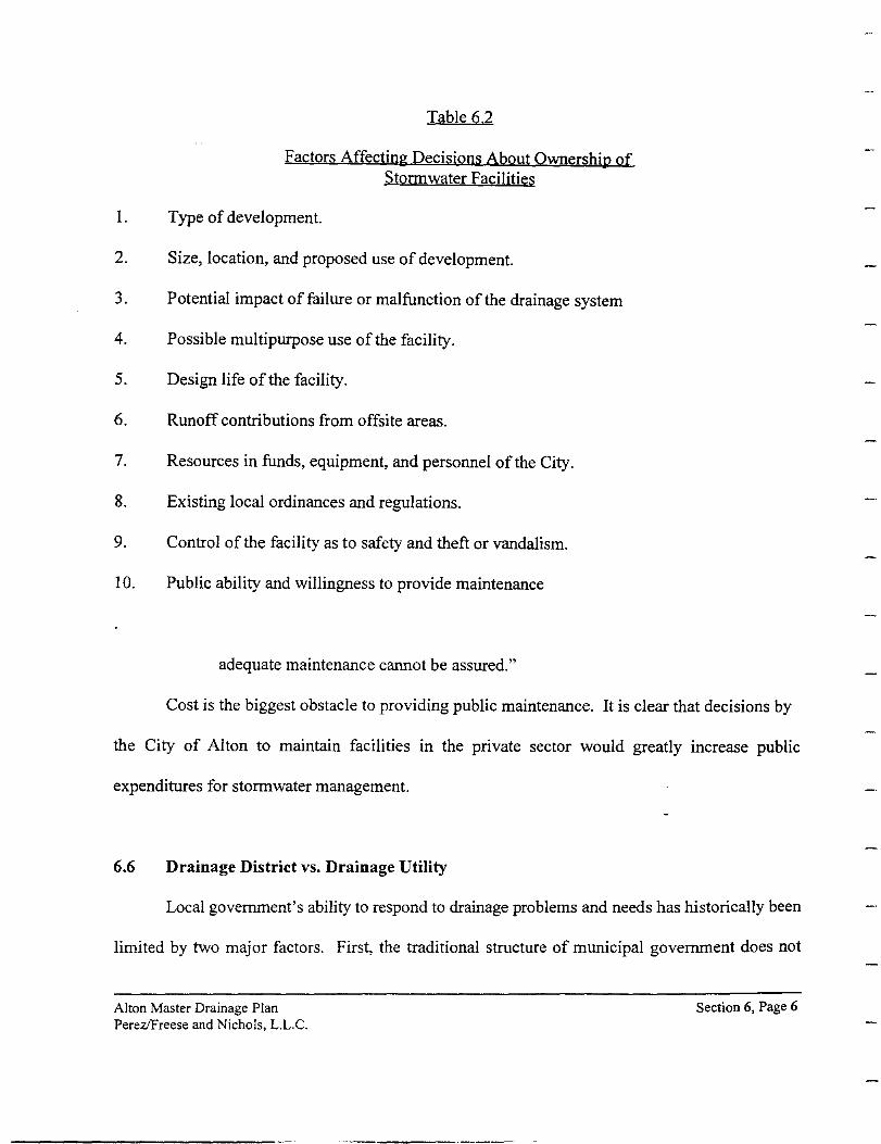
Table 6.2
Factors Affecting Decisions About Ownership of Storrnwater Facilities
I. Type of development.
2. Size, location, and proposed use of development.
3. Potential impact of failure or malfunction of the drainage system
4. Possible multipurpose use of the facility.
5. Design life of the facility.
6. Runoff contributions from offsite areas.
7. Resources in funds, equipment, and personnel of the City.
8. Existing local ordinances and regulations.
9. Control of the facility as to safety and theft or vandalism.
I 0. Public ability and willingness to provide maintenance
adequate maintenance cannot be assured."
Cost is the biggest obstacle to providing public maintenance. It is clear that decisions by
the City of Alton to maintain facilities in the private sector would greatly increase public
expenditures for storm water management.
6.6 Drainage District vs. Drainage Utility
Local government's ability to respond to drainage problems and needs has historically been
limited by two major factors. First, the traditional structure of municipal government does not
Alton Master Drainage Plan Perez/Freese and Nichols, L.L.C.
Section 6, Page 6
provide an organizational focus for drainage activities. The second obstacle has been the lack of
stable, adequate, and publicly acceptable financing methods.
Public work's strategies tried and proven in dealing with other municipal problems have not
always adapted well to drainage applications. Cities have had to seek or develop creative
new alternatives for meeting the stormwater challenge. Two such alternatives are described herein:
drainage districts and drainage utilities are as follows:
I. Drainage districts are special-purpose local government agencies authorized to deal with
watershed management. In Texas, they may levy valorem taxes and issue bonds; as of June 1987,
they are also authorized to impose capital recovery fees. These special-purpose governments lack
many of the essential general-purpose responsibilities of cities and counties which enable a
comprehensive approach to urban runoff management, such as land-use control and police powers.
Many special districts have been used successfully for drainage control in rural agricultural areas,
but their track record in urban communities, especially those undergoing rapid growth, has been
poor.
The creation of drainage districts as political subdivisions assures local control over water
resources. However, the state does exercise substantial control over most districts through approval
of plans for development projects and continuing supervision, primarily regarding fmancial matters,
by the Texas Natural Resources Conservation Commission.
2. A Storm Drainage Utility is a special-purpose organization within the City government
given the responsibility to provide for public needs in the area of storm water management. In the
same way that the Water and Wastewater and Electric Utilities are self-supporting, the Drainage
Alton Master Drainage Plan Perez!Freese and Nichols, L.L.C.
Section 6, Page 7
Utility charges fees for the operations and maintenance of facilities and for capital improvements.
Storm drainage utilities provide a variety of services including maintenance of detention
ponds, repair and cleaning of catch basins and storm sewers, as well as monitoring storm water
quality. The utility staff reviews new developments and subdivisions to ensure that they provide
adequate drainage facilities and share in the cost of basin improvements. These functions, along
with administration, budgeting, and answering questions from the public, are part of the operations
of a storm drainage utility.
6. 7 Summation
There are many options available to the City of Alton on how it can manage a storm water
management program. The City of Alton needs to review the administrative and managerial options
and establish an organizational system which by definition could oversee the stormwater
management program.
·~
Alton Master Drainage Plan Perezlfreese and Nichols, L.L.C.
Section 6, Page 8
7.0 Suggested Drainage and Storm water Management Policy
7.1 Purpose
A drainage and storm water management policy to establish the general framework of the
desired management program needs to be formally adopted by the City of Alton. The general
purpose of the proposed City of Alton's drainage and stormwater management policy would be
to protect and provide for the safety and welfare of the general public and to minimize and
mitigate flood damage to private and public property within the community, and to establish
methods of fiscal responsibility by developers. A suggested policy is summarized in the sections
below. The objective of this suggested policy is to identify an outline of the key elements that can
be used to establish a stormwater management policy for the City of Alton. The City of Alton
should thoroughly review this suggested policy and then adopt one that meets its specific needs.
7.2 Suggestions for a Drainage and Stonnwater Management Policies
It shall be the City of Alton's policy to:
• Incorporate natural floodways in areas of new development
• Establish management practices to be used for the drainage and control of
stormwater runoff and flood waters, where it can be shown the use of natural
floodways will not adequately protect life and property.
The order of preference for structural techniques is as follows:
a. Conveyance-oriented approaches
Alton Drainage Design Manual Perez/Freese & Nichols, L.L.C.
Section 7, Page 1
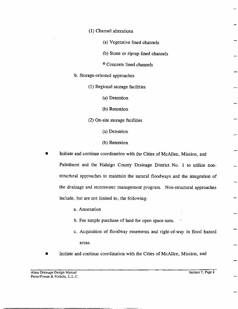
(1) Channel alterations
(a) Vegetative lined channels
(b) Stone or rip rap lined channels
cc Concrete lined channels
b. Storage-oriented approaches
(1) Regional storage facilities
(a) Detention
(b) Retention
(2) On-site storage facilities
(a) Detention
(b) Retention
• Initiate and continue coordination with the Cities of McAllen, Mission, and
Palmhurst and the Hidalgo County Drainage District No. 1 to utilize non-
structural approaches to maintain the natural floodways and the integration of
the drainage and stormwater management program. Non-structural approaches
include, but are not limited to, the following:
a. Annexation
b. Fee simple purchase of land for open space uses.
c. Acquisition of floodway easements and right-of-way in flood hazard
areas.
• Initiate and continue coordination with the Cities of McAllen, Mission, and
Alton Drainage Design Manual Perez/Freese & Nichols, L.L.C.
Section 7, Page 2

Palmhurst and the Hidalgo County Drainage District No. 1 on the use of
structural approaches to manage the drainage and stormwater management
improvements
7.3 Application of Drainage and Stormwater Management Policy
A City's policies for drainage and stormwater management govern the planning, design,
construction and operation of storm drainage facilities within the City's jurisdiction. A drainage
and stormwater management policy should based on the City of Alton's Code of Ordinances, the
Drainage Design Manual, and this Report. Each should be considered effective on the date of
acceptance by the Alton City Board of Alderman. The overall drainage and stormwater
management policy should apply to any drainage and stormwater management system
improvement not having plans released for construction as of the date of the City's approval of
this manual.
7.4 Regional Stormwater Management
To limit the impact of development and corresponding storm runoff within the Hidalgo
County Drainage District No. 1 's (HCDD No.1) Main Ditch(s) watershed(s) and to provide flood
control in that area, regional stormwater management must be implemented by the City of Alton
in a coordinated effort with the Hidalgo County Drainage District No.1 and the surrounding
communities. All inflows into the Hidalgo County System are limited in accordance with the rules
and regulations of the HCDD No.1 and all latest permit requirements for discharge into such
Alton Drainage Design Manual Perez/Freese & Nichols, L.L.C.
Section 7, Page 3
county ditches must be adhered to.
7.5 Drainage System Classifications
Major Drainage Systems: Major drainage facilities should include natural or improved
manmade channels, detention reservoirs (Natural or manmade), bridges or roadway culverts,
overflow swales and street rights-of-way. In certain instances, an enclosed storm drain pipe
system may be considered part of a major drainage facility if it drains a sump area. The design
storm, as defined by the 100-year frequency flood, must be contained within the right-of-way or
dedicated easement of all major drainage systems to provide for public safety and welfare.
Minor Drainage Systems: Minor drainage systems are intended to provide conveyance
for more frequent occurring flooding and usually consist of streets, storm drain inlets, pipes,
roadside ditches and driveway culverts. To enhance the quality of life and provide for public
safety, minor drainage systems are required to provide conveyance for the 10-year frequency flood
under fully developed watershed conditions.
7.6 Drainage and Storm water Management Plans Submittals
A review process should be established by the City of Alton to provide control of all
development activities related to drainage and stormwater runoff through natural or manmade
facilities. As part of the review process, a preliminary drainage plan containing a conceptual
layout of the proposed storm drainage system must be submitted as part of the preliminary platting
process.
Alton Drainage Design Manual Perez/Freese & Nichols, L.L.C.
Section 7, Page 4
When land development is proposed contrary to those assumptions used in the development
of the Master Plan, detailed analysis of the drainage and stormwater facilities for the development
will be provided by the developer's engineer to determine the need to compensate for the
additional runoff created above that for current conditions.
The developer requesting a change in land use should be required to compensate for the
additional runoff in excess of that calculated for the existing conditions. Measures to be taken by
the developer should be approved by the City Administrator or designated representative.
Measures used to compensate for the additional runoff should be one or a combination of the
following methods and procedures, in order of preference:
• Acquisition and dedication to the City of additional downstream flooding easements
to include areas not previously flooded.
• Storm runoff conveyance by use if streets, improved channels, culverts, and storm
sewers to convey the runoff to the main drainage system_s or existing stormwater
conveyance systems whose discharge points are in the location of the major
drainage systems.
• On-site flow attenuation by the use of time of concentration extensions, ditch
attenuation with culvert under sizing, balancing of runoff coefficients (C), or
methods based upon sound engineering principals and approved by the City
Administrator or designated representative.
• Storm water detention structures.
Alton Drainage Design Manual Perez/Freese & Nichols, L.L.C.
Section 7, Page 5
A final drainage plan must be submitted at the time of the final plat application. The final
drainage plan shall include the appropriate computation sheets as required in Section 2.8,
"Drainage Design Computations" of the City of Alton Drainage Design Manual.
7. 7 Floodplain Development
Development within and improvements to the 100-year floodplain should be consistent with
the improvements shown in this Manual and shall abide with all requirements of the Federal
Emergency Management Agency (FEMA) and the National Flood Insurance Program.
7.8 Drainage Structure Aesthetics
Hydraulic design in the urban environment requires an approach not encountered elsewhere
because appearance must be an integral part of the design. In an effort to maintain the natural
aesthetics of its existing floodplains, the City of Alton encourages preservation of the natural
floodplains and detention areas as greenbelt areas, and in some areas, the City may require the
floodplain be designated as a greenbelt area in addition to the developer providing drainage or
flowage easements. When utilized, the design of drop structures and other hydraulic structures
should blend with the natural surroundings as much as possible to maintain the aesthetics of the
natural occurring area.
Alton Drainage Design Manual Perez/Freese & Nichols, L.L.C.
Section 7, Page 6
7.9 Drainage Design Computations
Computations to support all drainage designs should be submitted to the City Administrator
or designated representative for review and approval as part of the final drainage plan and should
be in the form of standard computation sheets as contained in the City of Alton Drainage Design
Manual. Computer programs (other than spreadsheets) used to perform computations shall be
limited to those referenced in that manual. All computations submitted should be certified by an
engineer experienced in municipal stormwater drainage design and registered in the State of Texas
in accordance with the requirements set forth by the Texas State Board of Registration for
Professional Engineers and in accordance with the City of Alton Code of Ordinances. Stormwater
runoff computations should be based upon conditions representing ultimate watershed development
in accordance with the Code of Ordinances and the Alton Master Drainage Plan.
7.10 Construction of Drainage and Stormwater Management Facilities
Development activities associated with the construction of drainage facilities must minimize
erosion caused during construction. The protection of trees and vegetation should be maximized
during construction of development activities. Whenever possible, the replacement of trees
destroyed by storm water management procedures is encouraged.
Alton Drainage Design Manual Perez/Freese & Nichols, L.L.C.
Section 7, Page 7
7.11 Maintenance of Drainage and Stormwater Management Facilities
The hydraulic integrity of major and minor drainage systems dedicated to and accepted by
the City of Alton will be maintained by the City of Alton. The hydraulic integrity of drainage
systems retained by the owner with approval of the City and not dedicated to the City of Alton
should be maintained by the owner. That is, all vegetative growth and foreign debris should be
removed from the private drainage facility periodically to insure proper conveyance of storm
waters. The appearance of drainage ways and floodplains, excluding the area between the top of
each channel bank, and overflow swales should be maintained by the adjacent property owners.
All drainage and stormwater management facilities constructed, installed or provided by
the owner should, upon acceptance by the City, become the property of the City. The City should
be responsible for the operation and maintenance of the accepted facilities.
The City should maintain all accepted public drainage facilities located within City-owned
land, city right-of-ways, and City easements. The City may maintain other accepted public
drainage facilities located within or adjacent to the City. Such public facilities include, but are
not limited to, open drainage ways and piped drainage ways constructed expressly for use by the
general public and as part of the City drainage facilities; bridges; roadside drainage ditches and
gutters; flood control facilities, including detention and retention storage, dikes, overflow
channels, pump stations, etc., that have been designed and constructed expressly for use by the
general public.
Duly authorized inspectors of the City should have the right of entry on the land or
premises where property owners are required to maintain drainage and stormwater management
Alton Drainage Design Manual Perez/Freese & Nichols, L.L.C.
Section 7. Page 8
facilities, for the purpose of inspection of the maintenance required. The City Administrator's
office should inspect the premises of each such facility approved at least once per year. Where
a noncompliance is found, the City should request in writing that the property owner comply.
This notice should describe the measures required to be taken. If, within one month of the notice,
the maintenance required is not accomplished, the City shall either:
• Cause the necessary restoration to be accomplished and assess the property owner
for the City's actual cost, or
• Bring an action for a mandatory injunction to require the property owner to
accomplish the necessary maintenance.
Alton Drainage Design Manual Perez/Freese & Nichols, L.L.C.
Section 7, Page 9
8.0 Discussion of Improvement Alternatives
The improvements described in this master plan represent, for the most part, only those mitior
construction projects that will be required to manage the drainage and storm water runoff for the
assumed conditions in the future. The assumption is made that the more localized drainage
improvements will be incorporated in the development of subdivisions following the criteria set forth
in the proposed Drainage Design Manual and will discharge into these major construction projects.
Within the developed area of the community, preliminary plans are included to relieve known,
existing drainage problems. Interim solutions to correct these problems that are consistent with the
long range master plan are suggested.
The described improvements are well planned based on the available data, but they should
be considered as conceptional or preliminary. Although there is always interest in more detailed
information in specific locations, the scope of the study does not permit detailed planning. The
terrain in the study area is relatively flat and the only limited topographic information (five-foot
contours) represents the principal constraint on detailed planning. The opinions of probable
construction cost are realistic, but sufficiently conservative, and they are adequate for fmancial
planning and the development of a concept for an improvement program that can be reasonably
managed by the community.
8.1 Planning Criteria
The applicable design criteria for an open channel in the proposed Drainage Design Manual
states that all improved channels shall be designed to carry the 1 0-year, based on the ultimate
Alton Master Drainage Plan Perez/Freese and Nichols, L.L.C.
Section 8, Page I
watershed development, and shall have one foot of freeboard. The proposed Drainage Design
Manual also states that the design shall assure that no flooding of buildings or other improvements
will occur for the 1 00-year frequency peak flow. Drainage easements are required on all channels
of sufficient width to contain the 1 00-year frequency peak flow. Improvements to channels and
creeks, to include culverts and bridges, are to be designed for the 25-year frequency storm.
Since the terrain in the study area is relatively flat and there are no clearly defined creeks, the
preliminary plans for major improvements have been sized to handle the 1 00-year frequency storm
within the constructed channel with one-foot of freeboard. Although this approach is conservative,
it is selected to meet the intent of the requirement that the design shall assure that no flooding of
buildings or other improvements will occur for the 1 00-year frequency flow peak.
The improved grassed lined channels have been shaped with a minimum bottom width of 10
feet, three to one side slopes, and a minimum depth of four feet ( three feet of flow depth and one
foot of freeboard). The relatively flat side slopes of the shape are intended to provide a drainage
path that is easily maintained with mowers. With additional planning for connecting routes and
landscaping of the overbank easement, these major drainage improvements have the potential of
being connected into a beneficial linear park system within the community.
Coordinating with and satisfying the criteria of the Hidalgo County Drainage District No. 1
is another key in the planning of the major improvements. The Hidalgo County Drainage
District No. 1 facilities are sized to handle slightly less than a ten-year frequency storm
(approximately a 9.5-year storm) under existing conditions. As urbanization of the drainage areas
continue with its associated increase in the rate and quality of runoff, the rate of discharge for the
Alton Master Drainage Plan Perez!Freese and Nichols, L.L.C.
Section 8, Page 2
ten-year frequency storm to the Hidalgo County Drainage District No. 1 ditches must be kept at the
same rate as existing conditions. To achieve this requirement, stormwater has to be stored in the
study area and to be released at a slower rate. This detention of drainage and storm water runoff can
be achieved by a number of smaller detention ponds in the watershed or by a larger detention pond
at the lower end of the watershed. In the Master Plan development, larger detention ponds at the
lower end of the watershed have been assumed. These detention storage facilities would likely be
planned, designed, constructed, and maintained by the City of Alton in conjunction with the major
drainage channels improvements.
The Texas Natural Resource Conservation Commission regulations governing detention
facilities have been reviewed for their applicability to the proposed detention facilities. The TNRCC
typically requires any dam designed to impound floodwater that is six feet or greater in height to be
permitted. Although some of the detention facilities proposed in this Master Plan will be higher
than six feet, no permitting will be required as long as there is no permanent storage of water within
the detention facilities. Therefore, since the proposed detention facilities are not planned to
permanently store water, no TNRCC permits should be required. However, should the fmal design
of a detention pond incorporate permanently ponded water to enhance the aesthetic quality of the
detention facility (i.e., such as in a park), an application must be made to the TNRCC for a permit.
Channel improvement projects often fall under the jurisdiction of the Corps of Engineers 404
permit program. In most cases, the work will most likely fall under one of two nationwide permits:
(1) Nationwide 26, and (2) Nationwide 3.
The Nationwide 26 permit is required for fill (improvements) within channel areas below the
Alton Master Drainage Plan Perez/Freese and Nichols, L.L.C.
Section 8, Page 3

headwaters of the waters of the United States. The point, at which a stream is below the headwaters,
approaches a contributing drainage area on the order of25 square miles. The permit allows up to
ten acres below the normal high water mark upstream of the headwaters to be filled (modified). The
normal high water mark is usually observed as the distinct point at which vegetation along the stream
ends. If the improvements below the high water mark are less than one acre, no formal notification
to the Corps is necessary.
The other permit that may cover a portion of the channel is the Nationwide 3 Permit. Under
this permit, repairs are authorized for maintenance of existing channels. This permit could cover the
connections to the existing Hidalgo County Drainage District No.1 ditches. Under this permit,
repairs are authorized for the maintenance of existing channels.
8.2 Coordination with Surrounding Jurisdictions
The limit of the area over which the City of Alton has direct control is only a portion of the
study area. The future limits of the City of Alton extend to Four Mile Road on the south, to
Sharyland Road on the east, to Five Mile Road on the north, and to Moore Field Road on the west.
The City ofPalmhurst lies to the south, McAllen borders the city on the east and north, and Mission
lies to the west. Fairly specific conceptual or preliminary improvements are defmed within the limits
of the City of Alton jurisdiction. Since improvements outside the limits of the C_ity of Alton will be
the responsibility of other jurisdictions, they have been developed in a more
general manner to illustrate how the drainage and storm water runoff can be managed in the entire
Alton Master Drainage Plan Perez!Freese and Nichols, L.L.C.
Section 8, Page 4

study area.
Four Mile Road acts as an effective drainage boundary between the Cities of Alton and
Palmhurst. The Master Plan assumes that the detail planning drainage and stormwater management
facilities for the area south of Four Mile Road will be the responsibility of the City of Palmhurst.
A general concept of how this area can be served is illustrated.
The City of McAllen currently has planning underway for the area to the east of Alton.
Facilities within the City of Alton of have been planned to limit the discharge from the ultimate 10-
year frequency storm to the same level as from the existing I 0-year frequency storm. The improved
channels within the City of Alton are sized to handle the l 00-year frequency storm within the
channel. This approach needs to be coordinated with the City of McAllen to avoid a lack of
congruency at the boundary between the two cities.
A narrow strip of McAllen exists between Six Mile Road and the Hidalgo County Drainage
District No. I ditch to the north of the City of Alton. Since the discharge into this ditch of the I 0-
year frequency storm is to be limited to that from existing conditions, detention storage will be
required in the northern portion of the City of Alton. To avoid the need for multiple smaller
detention facilities, this area would appear to be an excellent candidate regional detention facilities
that could be shared by the two communities. This approach has been utilized in the planning the
drainage and stonnwater improvements for this area base on the assumption thaJ an agreement can
be reached.
On the west side of Alton, the Main Canal and the Hidalgo County Drainage District No. I
Alton Master Drainage Plan Perez/Freese and Nichols, L.L.C.
Section 8, Page 5

ditch stretches across the city between Inspiration Road and Los Ebanos Road. Drainage and
stormwater nmoff in the area to the west of this boundary can be collected in an improved channel
and detained in ponds to meet the criteria of the Hidalgo County Drainage District No. I criteria.
This concept has been incorporated in the specific master planning for the City of Alton; however,
this area is also a potential candidate for coordination with the City of Mission.
8.3 Drainage and Stormwater Management Plans
Appendix A contains the drainage maps showing proposed drainage and stormwater
management facilities. The existing facilities are shown on a separate map that has been furnished
to the city. Generally, the maps of the proposed facilities provide the following information:
• Drainage areas contributing to the stormwater collection points and channels are
identified by area designation
• Drainage channels are improved earth (grass-lined) channels and "Concrete Lined"
for concrete lined channels. The bottom width, depth of the channel, channel slope
and the I 00-year frequency discharge are also provided.
• It is assumed that the proposed improved grass-lined channels have a roughness
coefficient 0.027.
• Proposed culverts and inverted siphons are identified by size and_ number of barrels,
and the I 00-year frequency discharge is provided. It is assumed that all of the
proposed culvert improvements are either reinforced concrete pipe or reinforced
concrete box sections.
Alton Master Drainage Plan Perez!Freese and Nichols, L.L.C.
Section 8, Page 6
Hydrologic Design Considerations: The hydrologic considerations used in the
determination of the design discharges are based on the criteria and methodologies as defmed in the
City of Alton proposed Drainage Design Manual, which is assumed to be adopted as part of the
Subdivision and Land Development Regulations. Additional constraints are utilized in the
evaluation of drainage areas due to the uncertainty of future drainage boundary locations.
Drainage area boundaries generally follow natural drainage divides. In cases where existing
or future major roadways and existing and future irrigation canals interrupt the natural flow path, the
drainage area boundary follows the roadway or irrigation canal: that is, flow is assumed to cross a
major roadway or irrigation canal only at a location where closed pipe systems or drainage channels
would likely cross the roadway or canal.
Hydraulic Design Considerations: The procedures for determining the required storm drain
pipe and channel designs are outlined in the City of Alton proposed Drainage Design Manual.
Additional constraints were imposed due to the unpredictability of future development (particularly
street layouts) which allow flexibility for future storm drain designs in these areas. More
specifically, hydraulic design considerations used to determine the required storm drain systems were
based on the items listed below:
Open Channel Systems
• Proposed drainage channels generally follow the natural flow paths.
• Open channels were based on the 1 00-year frequency flow capacity. The depths for
improved (grass-lined) channels were based on the 1 00-year frequency depth plus
one foot.
Alton Master Drainage Plan Perez!Freese and Nichols, L.L.C.
Section 8, Page 7

• Culverts and inverted siphons in channels that cross major roadways and irrigation
canals were designed to convey the I 00-year frequency discharge from the upstream
drainage area.
• Grass-lined drainage channels are unlined, earthen trapezoidal channels with a
minimum bottom width of ten feet, sideslopes of 3: I and a corresponding roughness
coefficient equal to 0.027.
• The maximum allowable design flow velocity was 6 feet per second for grass-lined
channels.
8.4 Preliminary Estimate of Probable Construction Cost
Summarized in Table 8.I are the preliminary estimates of probable construction cost for the
major elements in the Master Drainage Plan for the ultimate conditions within the detailed study
area. The total preliminary estimate of the probable construction cost for these major elements is
$ 40,I77,300. Preliminary estimate of the probable construction cost for the improvements shown
on Shart 3A and 3B have not been developed because they are within the City ofPalmhurst and are
not the responsibility of the City of Alton. The details on the development of these preliminary
estimates of probable construction costs are included in Appendix B.
In addition to these major elements, local storm drainage projects will b~ required to convey
the storm runoff to these major elements. In developing areas, these local conveyance systems are
assumed to be incorporated in the planning and design of developments. The construction cost for
these local conveyance systems will be included in the cost of the development.
Alton Master Drainage Plan Perez/Freese and Nichols, L.L.C.
Section 8, Page 8
Local stormwater conveyance systems will also be required in some currently developed
areas of the City of Alton. The specific detailed planning of these improvement projects is beyond
the scope of this study. Specific detailed planning requires field surveying and/or more detailed
topographic maps which were not included as a part of this study. To account for the cost of these
local stormwater conveyance systems which will likely be borne either totally, or in part, by the
citizens of Alton, an allowance of$ 6,800 per currently developed acre has been included in the
preliminary estimates of probable construction cost. For the estimated currently developed acreage,
this adds $ 4,500,000 to the construction cost. Including this estimate for the local stormwater
conveyance systems in the currently developed area, increases the total preliminary estimated
probable construction cost to$ 44,677,300. A portion of this cost could be shared with adjacent
cities if regional facilities were developed.
8.5 Preliminary Estimate of Probable Annual Operation and Maintenance Cost
Initially, the City of Alton can use existing city personnel to man and operate the watershed
and storm drainage management program. However, once the program has been fully established,
funding should be available to provide for personnel, administrative, and maintenance needs.
Depending on the rate at which development takes place, minimum staffing requirements would be
clerk/typist at$ 34,300 and a staff engineer at$ 88,000, or a total of $12:poo. This amount
includes allowances for salary burden and office space and supplies.
It is assumed that the maintenance of the drainage facilities would be handled through out-
sourced contracts. Using the information presented in Section 4.4, on page 4.3, for recently
Alton Master Drainage Plan Perez/Freese and Nichols, L.L.C.
Section 8, Page 9

Table 8.1
Summary of Preliminary Estimate of Probable Construction Costs
Project
South Central Area
South Central Drainage Ditch
Improvements to Five Mile and Bryan Road Detention
Subtotal
Southeast Area
Southeast Drainage Ditch
Sharyland and Four Mile Detention
Subtotal
Northeast Area
East Drainage Ditch
Northeast Drainage Ditch
Glasscock and Six Mile Detention
Subtotal
North Central Area
North Central Drainage Ditch
Bryan and Six Mile Detention
Mayberry and Six Mile Detention
Subtotal
Alton Master Drainage Plan Perez!Freese and Nichols, L.L.C.
Preliminarv Estimate of
Probable Construction Costs
$ 4,406,200
$ 6.641.700
$ 11,047,900
$ 2,735,700
$ 3.190.000
$ 5,925,700
$ 1,683,900
$ 756,300
$ 5.340.100
$ 7,780,300
$ 1,184,200
$ 1,111,500
$ J ,438,5QO
$ 3,734,200
Section 8, Page I 0
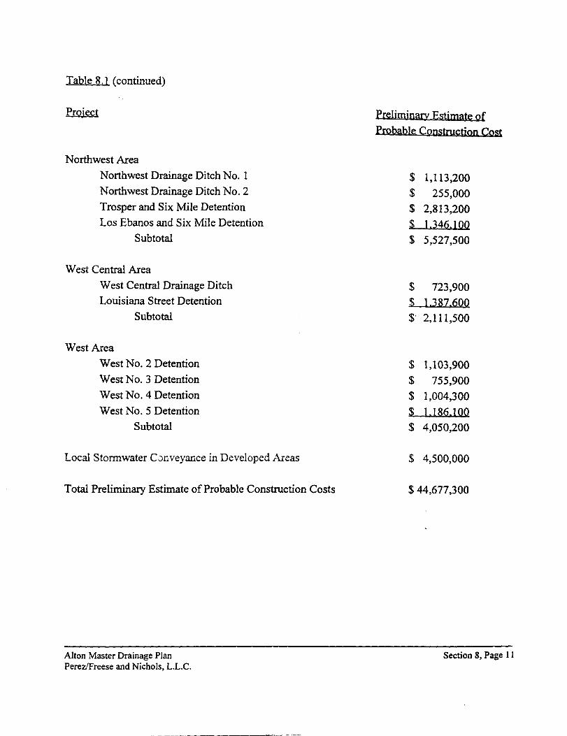
Table 8.1 (continued)
Project
Northwest Area
Northwest Drainage Ditch No. 1
Northwest Drainage Ditch No. 2
Trosper and Six Mile Detention
Los Ebanos and Six Mile Detention
Subtotal
West Central Area
West Central Drainage Ditch
Louisiana Street Detention
Subtotal
West Area
West No.2 Detention
West No.3 Detention
West No.4 Detention
West No.5 Detention
Subtotal
Local Stormwater CJnveyance in Developed Areas
Total Preliminary Estimate of Probable Construction Costs
Alton Master Drainage Plan Perez/Freese and Nichols, L.L.C.
Preliminary Estimate of
Probable Construction Cost
$ 1,113,200 $ 255,000 $ 2,813,200
$ 1.34!2.1QQ $ 5,527,500
$ 723,900
$ U87,6QQ
$ 2,111,500
$ 1 '1 03,900 $ 755,900 $ 1,004,300
$ l.l8!2.1QQ $ 4,050,200
$ 4,500,000
$ 44,677,300
Section 8, Page 11

constructed or proposed facilities, the maintenance cost can be estimated as 3 to 5 % of the base
construction cost. If average conditions are assumed and full development has occurred, the
estimated annual maintenance cost would be $ I, 787, I 00 in I 997 dollars. This amount will increase
with inflation and as facilities age. Experience in the operation and maintenance of the initial
facilities should provide excellent guidance in the establishment of annual operating budgets.
Alton Master Drainage Plan Perez!Freese and Nichols, L.L.C.
Section 8, Page 12

9.0 Recommended Master Plan Improvements
The drainage and stormwater management facilities as illustrated on Sheets A-1 through B-3
are recommended as the Master Plan improvements for the City of Alton. These improvements are
planned to meet the ultimate development conditions within the extraterritorial jurisdiction of the
City of Alton. They have received initial coordination with the surrounding communities and
Hidalgo County, but this effort should be pursued on a continuous basis as the detailed plans are
developed for these improvements.
9.1 Discussion of the Economic Feasibility
The preliminary estimate of the probable total construction cost, in the amount of
$ 44,677,300, is certainly a significant sum of money. For the City of Alton to consider
the expenditure of such an amount at this time is challenging. What has to be kept in mind is that
the development of the drainage and stormwater management system will occur over several years
as the community develops.
The test for the reasonableness of the plan at this point in time is whether the total estimated
construction cost per person, when the community is totally developed, is realistic. Within the
boundaries of the extraterritorial jurisdiction of the City of Alton, there are approximately 5,640
acres. If there is an average of four housing units per acre and an average of four persons per
housing unit, then unit costs can be developed. For the approximately 5,640 acres, the unit cost in
1997 dollars would be approximately$ 2,000 per dwelling unit, or$ 500 per person.
Although these are significant amounts, they are certainly within the range of reasonableness.
Alton Master Drainage Plan Perez/Freese and Nichols, L.L.C.
Section 9, Page I

Planning now to make these investments in the implementation of the drainage and stormwater
master plan over the next two to three decades will result in a higher quality of life for all the citizens
of the City of Alton.
9.2 Discussion of Safety Considerations
Safety always has to be considered in the planning and design of public works projects. This
fact is particularly true with water related projects. Most people find water in a tranquil state, such
as a lake or pond, to be pleasant and relaxing. Water in a turbulent state, can be very stimulating and
exciting. This can be particularly true for young children who have not developed an appreciation
for the danger.
To partially address safety issues the preliminary plans have been developed to the maximum
extent possible with wide shallow drainage ditches. The side slopes of the ditches are planned with
three feet of width for one foot of rise. This relatively flat side slope approach should allow someone
who is caught in the stormwater to exit more easily. Also, regular maintenance of the grass lined
drainage ditches will be critically important to maintain their functionality. Mowing of the side
slopes, as well as the ditch bottom, will be more comfortably and safely accomplished with the flatter
side slopes.
The box culverts at road crossings and the inverted siphons at the irrigation canal crossing
may require some special considerations in their planning and design. These can be particularly
dangerous locations during higher stormflow rates. Warning signs and protective fencing may be
required in some locations. If the drainage ditch is particularly deep, safely devises can be installed
Alton Master Drainage Plan Perez/Freese and Nichols, L.L.C.
Section 9, Page 2

upstream to aid an individual caught in the stormwater to pull themselves out.
9.3 Discussion of Environmental Concerns
Environmental concerns are part of the City of Alton. The Board of Aldermen recently took
the necessary steps to enhance habitat for birds within the city. The actual construction of the
proposed drainage and stormwater management facilities may have some negative impact on the
environment. Some of the proposed facilities are located along natural drainage paths where native
vegetation exist. This locations are also likely the homes of the native habitat and potential wetlands
may also occur.
Detail evaluation of the environmental impact of the proposed improvements is beyond
the scope of this study. Based on available mapping and aerial photographs, alignments were
selected that avoided developed areas to the maximum extent possible and to take advantage of the
natural terrain. Consideration of the environmental impacts would logically be included in the detail
planning and design of each improvement.
Although the construction of the proposed improvements will have a negative impact on the
environment during the construction, following the completion an opportunity exists to restore and
perhaps enhance the environment. The planned right-of-ways for the proposed drainage ditches are
adequate for the construction and maintenance of the facilities. In most locatio~ along the right-of-
way, it should be possible to include landscaping on the overbank that would not interfere with the
functionality of the ditch and the maintenance of the facility.
Alton Master Drainage Plan Perez/Freese and Nichols, L.L.C.
Section 9, Page 3

9.4 Discussion of Aesthetics
A frequent initial negative reaction to planning and construction of drainage and stormwater
management projects occurs in almost every project. This condition is particularly true where
concrete lined channels are required in developed areas due to limited space. The proposed grassed
lined drainage ditches can, with proper planning, become a positive benefit to the community and
improve the overall aesthetics of the City of Alton.
SH 107 is and will continue to be major North-south transportation artery through the heart
of Alton. Many of the proposed drainage ditches cross or are planned near SH 107. With care full
planning, the overbank space along the drainage ditches can be used for walking, hike and bike trails
that would connect residential neighborhoods with this transportation linl<. Even those drainage
facilities not directly adjacent to SH 107 could be utilized as walkways, and hike-bike trails. With
some fairly short connecting segments, all the potential walkways and hike-bike trails along the
drainage ditches could be joined to create an extensive network through all segments of the city.
Coupling this effort with the proposed environmental landscaping concepts discussed above could
result in an exceptional amenity for all sections of the city.
An additional opportunity to increase the aesthetics of the community is the use of the
detention basins' bottom areas as athletic fields. The right-of-way area around the detention basins
could be landscaped and used as neighborhood park space along with the grassed play area in the
bottom of the basin. Funding to plan and construct these types of projects could be available though
the TexDOT ISTEA Program and the Texas Parks and Wildlife.
Alton Master Drainage Plan Perez/Freese and Nichols, L.L.C.
Section 9, Page 4
10.0 Implementation Schedule
The following proposed implementation schedule is based on an understanding of the
storm water drainage pattern developed during the preparation of the report. The current growth
pattern of the City of Alton was also considered during the development ofthis implementation
schedule. The proposed schedule should be reviewed at regular intervals, but certainly at least every
five years.
10.1 Immediately, or during the First Year
Using the general framework outlined in Section 7 and the information contained in this
Master Drainage Plan and the Drainage Design Manual, the City of Alton needs to establish and
formally adopt a drainage and storm water management policy.
Stormwater runoff does not recognize established jurisdiction lines and close coordination
with the surrounding communities ( McAllen, Mission, and Palmhurst) is essential for a successful
stormwater management program. The role that the City of Alton should play in proactively seeking
to establish a regional stormwater management program should be thoroughly considered. Such a
stormwater management plan can be implemented through a consortium of local governments and
Hidalgo County. A steering committee can be established to make recommendations to the
respective political bodies within the watershed. However, not being a legislative body, the
watershed management group's recommendations may be ignored or given a low priority for action
by the individual units of government.
A procedure is needed for pulling watershed communities together through a common theme.
Alton Master Drainage Plan Perez/Freese and Nichols, L.L.C.
Section 10, Page 1

Some sequential steps might included:
1. Organize a series of public meetings to explore the problems and opportunities
that need to be addressed.
2. Identify the resources that can be used to assist with watershed planning and
implementation.
3. Formulate watershed management alternatives.
4. Select a publicly acceptable watershed management alternative.
5. Implement the watershed management alternative.
There are many options available to the City of Alton on how it can manage a stormwater
management program. The City of Alton needs to review the administrative and managerial options
outlined in Section 6 and establish a plan for an organizational system to oversee the storm water
management program.
Historically, stormwater management has been financed using general fund revenues for
annual operating expenses and a mix of revenue sources for capital improvements. The City of Alton
needs to review the financing options outlined in Section 5 and adopt a combination that should
provide adequate funding for a storm water management program.
Two sections of the City of Alton's exterritorial jurisdictional area were identified that should
receive immediate attention during the first year. The recommended activities for the first year for
these first two areas are to perform a detail study, field surveying, the preparation of preliminary
construction plans, and a detailed estimate of the probable construction cost.
The first area is located northwest of the intersection of Five Mile Road North and Glasscock
Alton Master Drainage Plan Perez/Freese and Nichols, L.L.C.
Section I 0, Page 2
Road. The general limits of this area are illustrated on Figure I O.I. The streets in this area are
Alexandria Street, Bonnie Street, and two unnamed streets in the eastern portion. In the western
portion of the area, the existing streets are Jo Beth Lane, Linda Lane, and K & K. Localized flooding
is known to exist in all or part of this area.
The second area is located west of Stewart Road and south of Six Mile Road. The general
limits of this area are illustrated on Figure I 0.2. The streets in this area include Palm Drive, Mission
Drive, Lomita Drive, and two unnamed streets. Much of this area is located in a
natural low area, or basin, and is potentially subject to severe drainage problems.
Both of these areas need to be studied in greater detail to include field surveying and the
preparation of preliminary plans. This effort should include the preparation of a detailed opinion of
the probable construction cost. Based on this preliminary design effort, the City of Alton can make
specific plans on funding and on how and when to proceed with the preparation of final plans,
bidding, and the construction phase of the project.
Both of these areas will require the installation of local stormwater conveyance facilities.
To be consistent with the Master Plan, these local storm water conveyance facilities for the first area
should take the flow north to the proposed East Drainage Ditch. It is not economically feasible to
consider constructing the entire East Drainage Ditch at this time. An approach would be to construct
the portion of the East Drainage Ditch north of this area to create a stormwater_storage sump. The
size and shape should be consistent with proposed East Drainage Ditch and its length would be
dependent on the frequency of the storm to be stored. This approach would require the use of a
permanent or protable pump station to empty the sump. The use of portable sump pumps would
likely be the most economical approach since they could be used at other locations.
Alton Master Drainage Plan Perez/Freese and Nichols, L.L.C.
Section 10, Page 3

IMMEDIATE, OR DURING THE FIRST YEAR PROJECT No. 1
BW=IO' NATURAL TW=34'
SUMP
~~~~~~~~~o~=~r0~6§c§fs~~-ol~~~~ EAST DRAINAGE DITCH
0
0
ALTON LIMITS
BW=IO' TW=34' 0=89cfs
BW=IO' TW=34' 0=69cfs - .
I fw (IJ
0 --,
>:: u 0
K 8 K u ll UNNAMED ST. ~
0
~ NA~URAL
LLI ---~~~----~~(J) ___ ··~;~ SUMP
UNNAMED ST. « n:: 0 z
Nz f-•. -~~:-ro-B--;sO_NN,.-IE-,-S0T.",----;::url!~~" _l.---~ - ;v aT U R A -
0
<l: X w _j
<l:
ALEXANDRIA ST.
MILE 5 NORTH RD.
0 000
SCALE T • 400"
FIGURE 10.1

0
NATURAL · SUMP
IMMEDIATE, OR DURING THE FIRST YEAR PROJECT No. 2
MILE 6 NORTH RO
150
T U R A L 0 R~l N p A T H N A -
KANTUNIL DR.
JUAREZ DR.
PALM DR
LA POINTE
AL TOr--J CITY LIMITS ,
0
SCALE r - 400'
FIGURE 10.2

In the second area to be consistent with the Master Plan, the local stormwater conveyance
facilities should be designed to deliver the stormwater to the Northeast Drainage Ditch which, as
proposed, would pass through this second area. The size and shape should be consistent with the
proposed Northeast Drainage Ditch and its length would be dependent on the frequency of the storm
to be stored. The use of portable sump pumps would likely be the most economical approach since
they could be used at other locations.
10.2 The 1- to 5-year Period
The two projects evaluated during the first year should be funded and constructed during this
period. The exact schedule will be a function of the length of time required for the design process
and the process adopted to identify and arrange for the construction funding.
A third project that should be undertaken during this period is the detail study, planning,
right-of way acquisition, and preliminary design of the West Central Drainage Ditch and the
Louisiana Street Detention Basin. The general location and extent of this project are illustrated on
Figure 10.3. Due to the general slope of the terrain, much of the stormwater runoff from this area
west of the developed area of Alton would naturally pass through the city. As this western area
develops and the runoff increases, drainage through the developed area of the City will increase. The
second concern with this improvement is the need to identify a specific routing for the West Central
Drainage Ditch through the partially developed section of Alton between Louisiana Street and
Delaware Street.
10.3 The 6- to 10-year Period
Alton Master Drainage Plan Perez/Freese and Nichols, L.L.C.
Section 10, Page 4
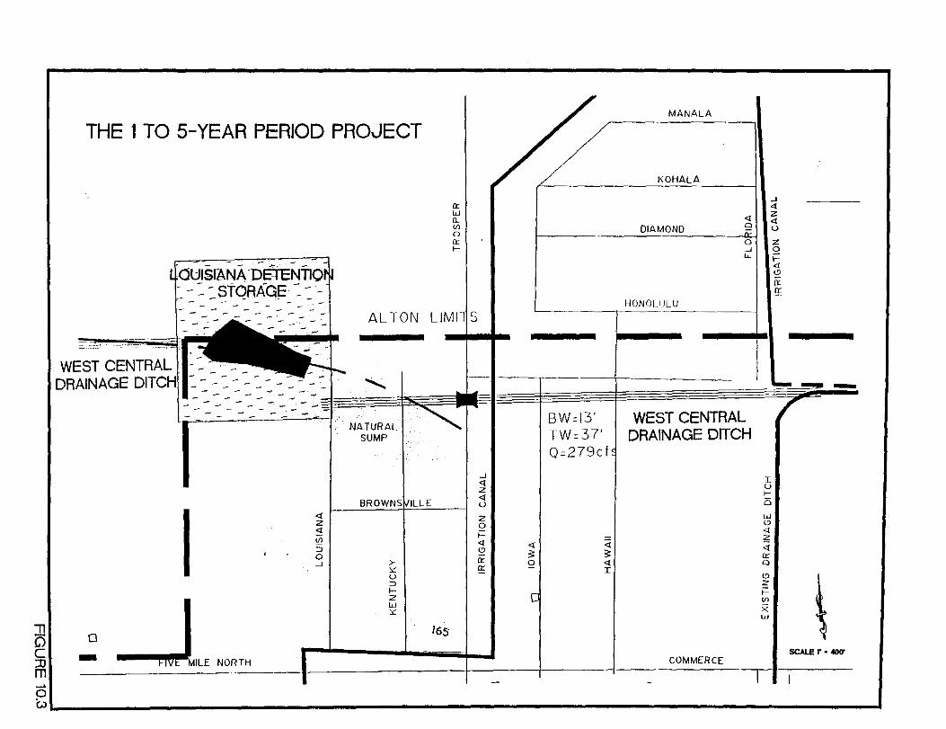
, C) c ::0 m __. 0
THE 1 TO 5-YEAR PERIOD PROJECT
I -0
_J,OLE '0"'"
<I z <I Ul
::> 0 --' >-:.::
u ::> 1--2 ~I :.::
165
0::
I I w 0.. Ul 0 0:: 1--
BW=i3' TW=37' 0=279cf
z 0 t= <I <I <I <!) :;;: :;;: 0:: 2 <I ~ I
MANALA
KOHALA
.J <!
<I z <!
DIAMOND 9 u
0 z _j 0 u. i==
<! <!)
0: If -HONOLULU
I WEST CENTRAL DRAINAGE DITCH
I I u 1--i5 tu <!)
<! z <! £r 0
~I \ X uJ
- SCALE I" - -100' COMMERCE
WL---------------------------------------------------------------------------------------~
The principal project during this period should be the funding and construction of the West
Central Drainage Ditch and the Louisiana Detention Basin. The exact schedule will be a function
of the length oftime require for the design process and the process adopted to identify and arrange
for the construction funding.
A second major project scheduled for this period should be the detailed study, planning,
right-of-way acquisition and preliminary design of the Five Mile and Bryan Road Detention Basin
as illustrated on Figure 10.4. The location of this drainage improvement in the heart of the City of
Alton offers an opportunity for the consideration of a multi-use facility. A municipal park could
serve the citizens well in this location. If the concept of a number of walk, hike and bike trails
throughout the city is pursued, a park in this location of the city could easily serve as junction point
for many of the trails. When Alton reaches full development, it will likely have a population of
between 75,000 and 90,000. As this level of population is reached, other concepts that could be
incorporated in this detention basin would be an amphitheater with seats on one of the sloping sides,
or a challenging nine-hole, and perhaps an eighteen-hole, golf course.
Related projects that should be included in this detail study, planning, right-of-way
acquisition, and a preliminary design phase are:
• The need for an overflow ditch from the existing Mayberry Road Detention Basin
• The need for an additional overflow pipe or ditch from the existing detention basin between
Ave de Mexico and Linares and north of Campeche
• The culverts for the South Central Drainage Ditch under Five Mile Road.
• The stormwater pump station and discharge pipeline to the Hidalgo Drainage District No.
1 drainage ditch north of Six Mile Road.
Alton Master Drainage Plan Perez!Freese and Nichols, L.L.C.
Section I 0, Page 5
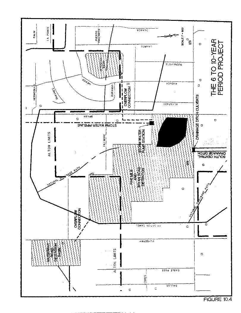
" I 0 J "1:)"vx-:o <0 '" . ....
:;,-~ .._ z
~ 0
0
a.
~ 0
< ~
S3CJ'i.'\jll
<f)
1-
~ ....J
2: 0 1-....J <(
/
S":l170
\. c c
FIGURE 10.4

10.4 The 11- to 15-year Period
The project elements associated with the Five Mile Road and Bryan Road Detention Basin
evaluated during the previous period should be funded and constructed during this period. The
exact schedule will be a function of the length of time required for the design process and the process
adopted to identify and arrange for the funding.
10.5 Improvements that can be Accommodated as Development Proceeds
The remainder of the drainage and stormwater improvements identified on Sheets 1-A
through 3-B should be studied and planned as development proceeds. The City of Alton needs to
consider and adopt a policy on methods that development will be required to follow to fund, or assist
in the funding of, these improvements. These policies need to be reasonably consistent with those
of the surrounding communities.
Alton Master Drainage Plan Perez/Freese and Nichols, L.L.C.
Section 10, Page 6

r-•
ll I (~II:Y ·f Al1.>on
M a·c; c .... ,~·t· e .. ·::\ r,, ~~.,')red.~~.-·~ .... -.: .. ' 1.r·. ·"at ........ ~,.~ e-.. - PI· a·.-. n . .. ' ' '\,-) . ' -"'"'" t ' ,. C,l, 11 I '""" ,,., . "'~"'·
;!II!'! )I'll: ;1 1 1'1!!11 j!:l!lllllll ALTONS ETJ BOUNDARY
CITY LltviiTS
-- S TUOY liM I fS
CANALS
- - - - - - - - UNDERGROUND IRR. PIPE
EXIS mJG DITCHES
W 1\ TER SHFD C.L
WATER SHFD
PROPOSED DRAI~I~GE DlfCH
"" 130X CUI'/EI<TS
• I~IVER fED SIPIW~IS
PROPOSED BASic!
EXISTING 13.'"SI~I
USGS ci_OOI) .'0~11':
~1997
2
)
t~
f-----
--1 ll - - +-------_
- ~ - =·H~=
B -I-
f--
a- fl-lr _I - w ~nR-f---------J
~c rHL~~ I J I'';", -" I_~ -- - -
h - 1--=F=- ~ I - ~
IL ~~-- -- - , +- ~~-r-=--=~~ If -- -
l l l~'h r~' ~ IJj
I·i Ji~~
c 0
Q_ ~
~ <ll r 0'
' 0 6 c ~ .2 :su ~ L
u 2 m 0
::;:
z =:;;== £ ., 0 g .; jj ••• ~ - I 8 !ii~!· ~ ,!lfll' ~ 1!~ i i ~ 'i! .l;
§ "~ ~: lj ~~ ~ ~ 'II ;;J. :t ...... , , n
I -~" ' ,,
:~I j!lll;
,lrJ
I
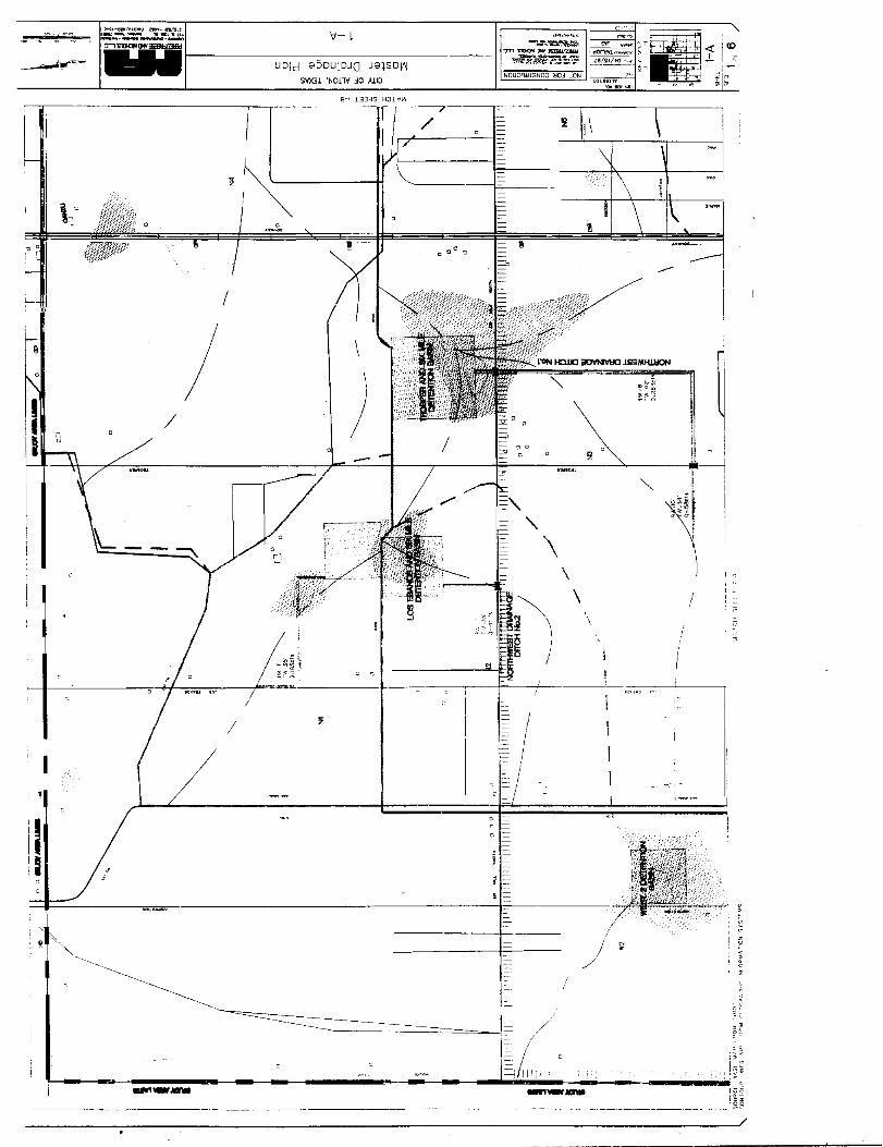
:~ It !II :II I ~
-·-tft/Qwo>J ~ln/Oit
=--:-~~~·~ v ~mat!M~ -,: .. ~
... r-------------U--D-Id---8~5-D_U_I_D_JQ---J-8-)S--D-~--------------I
70
--~~'~ S'fX3l 'NOlTV .:IO )JJO NOllOn~.lSNOO ~O.:i lON
g-• LDHS HOl \1'~
\ \
\
. - ------- ·-------------------~----'--
-=====~:=~i;~.~~·~~~~·--;"~;:.,~.~~"~,,~o~~"----------------------~8~-~l--·-------------------r;============;======~-;;;====;-----,
' ,, !.: iJ.rlr------------;:-----------------j --------.,t=- UCfd 8DDUIDJQ J<'llSDfAj
SV>Gl 't..Ol"W .:!0 )JJ8
!!
/ I
'
I
I
I • [_
--...:-~~~~ .,.,.,~OINJ5Dl~
~~·~~':~
I i 11111111 i i 111[111 "119 I ~ II I rri:r'n'i ! II II ! i II
I I '
I I
I
~J. 7 'f'
\
------~=-
'Slr-1'-l r,·:·-
-· ~-
I I
I 1
1 I
I
I ,, if I
r
I
~ .-
------,-----,--------------------
/
! I
il
i I
I~
/ , __
-------1
/ r _--- __ .--_--__ ---_ -_-___ /-•---•l-0/ .. _-_\ ,/
------
\ \: ,,
,._1' - I
I I
--------~
I ------ ___ I_
/
/
_,
t- I
\ I ~
-- ___ ) ___ ·-~--
/
/ \ '\
-- .
=-::_1
/
r __ __.-/ I
e ...........
-----11 ----<!I
I
I
!I
i
I
I"
------~~~=------~-~------~-----+----~~---==-__L~ __
-~-;,-:-, .; "L--i
L_ L

I I
I_
\ / t
'
(
/
-T-""~~..,~ l"ll"S"'OQ~Q'I¥~Zl<L>d
~B::t~-:}:~~:~~
NOU.Ont~lSNO:J ~0.> lON
APPENDIX A
List of References

REFERENCES
(l) Eagle Point, Watershed Modeling. Third Edition, August 1994.
(2) Soil Conservation Service, U.S. Department of Agricultural, SCS National Engineering Handbook Section 4 Hydrology. August 1972.
(3) State Department of Highways and Public Transportation, State of Texas, Bridge Division. Hydraulic Manual. Third Edition, December 1985, p.2-14 and Table 6.
(4) Linsley, Ray K. Jr, Kohler, Max A., and Paulhaus, Joseph L.H., Hydrology for Engineers. p.228, McGraw-Hill Book Company, 1958.
(5) Cyre, Hector J., "Stormwater Management Financing," paper presented to the International Public Works Congress, American Public Works Association, 1982.
(6) Cyre, Hector J., "Developing a Stormwater Management Utility," APWA Reporter, March 1987.
(7) Maryland Department of the Environment, Sediment and Stormwater Division: A Planning Guide to Stormwater Management Utilities, draft, Annapolis, 1987.
(8) Texas Department of Community Affairs, City and County Assistance: Texas Communi tv Development Program, Austin, 1987.
(9) Texas Advisory Commission on Intergovernmental Relations: Handbook of Governments in Texas, Austin, 1984.
(1 0) Harman, Douglas and Diveley, Ann Long, "Fort Worth Improvement District: A First in Texas," Texas Town and City, September 1987.
APPENDIXB
Estimates of Probable Construction Cost
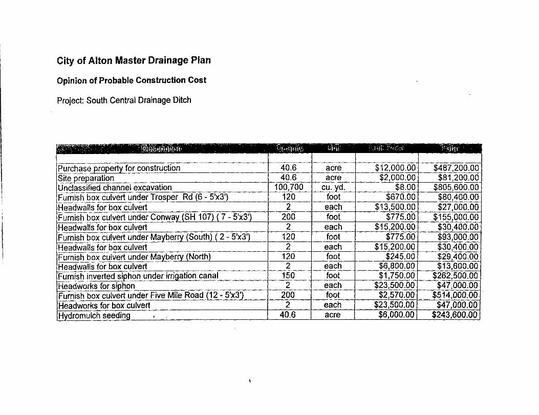
City of Alton Master Drainage Plan
Opinion of Probable Construction Cost
Project: South Central Drainage Ditch
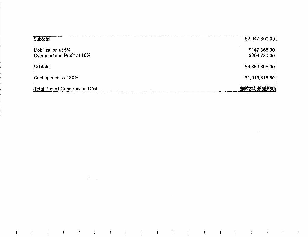
btotal
Mobilization at 5% Overhead and Profit at 1 0%
at 30%
Construction Cost
.00
$147,365,00 $294,730.00
$3,389,395.00
$1,016,818.50
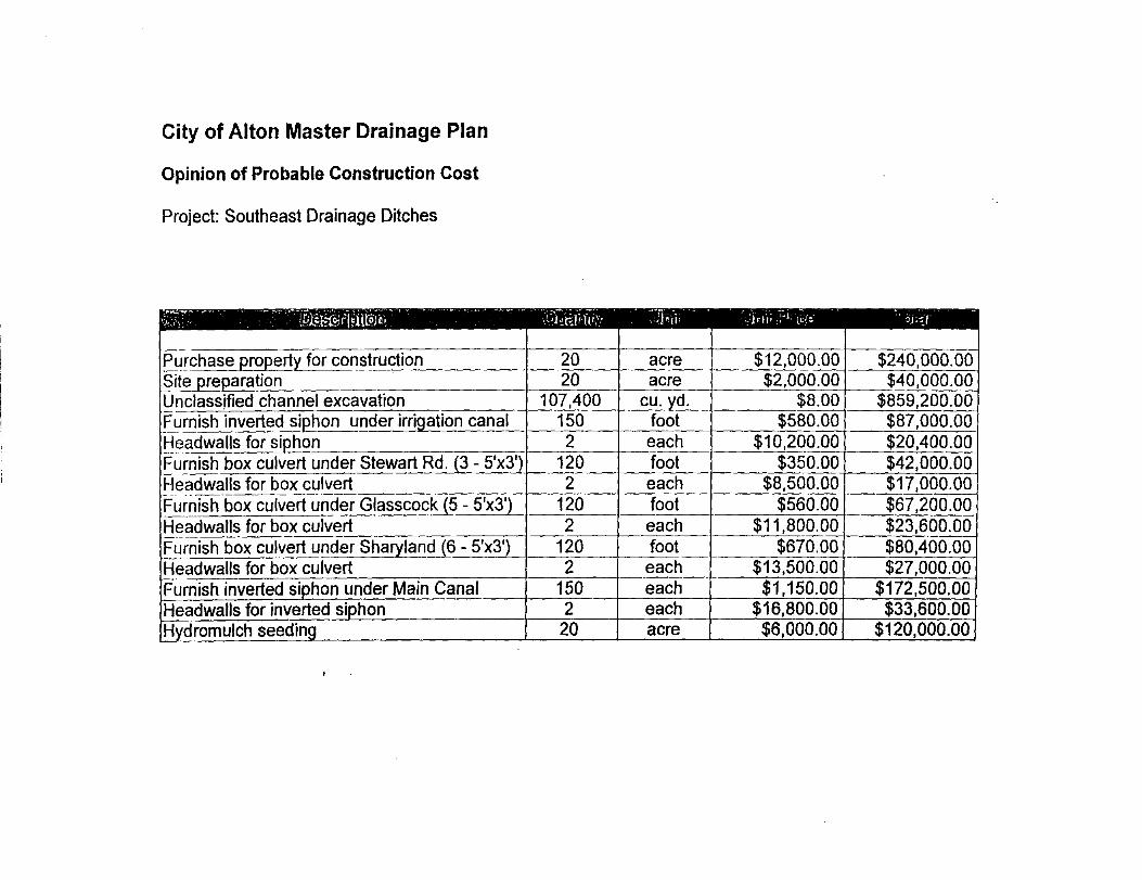
City of Alton Master Drainage Plan
Opinion of Probable Construction Cost
Project: Southeast Drainage Ditches

Project: Southeast Drainage Ditches- (continued)
Subtotal
Mobilization at 5% Overhead and Profit at 1 0%
Subtotal
Contingencies at 30%
PrniP.r.t Construction Cost
,829,900.00
$91,495.00 $182,990.00
$2,104,385.00
$631,315.50
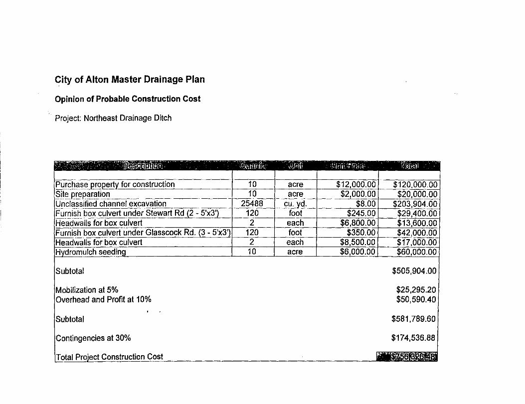
City of Alton Master Drainage Plan
Opinion of Probable Construction Cost
Project: Northeast Drainage Ditch
Subtotal
Mobilization at 5% Overhead and Profit at 10%
Subtotal
Contingencies at 30%
Construction Cost
$505,904.00
$25,295.20 $50,590.40
$581,789.60
$174,536.88

City of Alton Master Drainage Plan
Opinion of Probable Construction Cost
Project: East Drainage Ditches
Mobilization at 5% Overhead and Profit at 1 0%
Prni<>l't Construction Cost
$1 '126,376.00
$56,318.80 $112,637.60
$1,295,332.40
$388,599.72
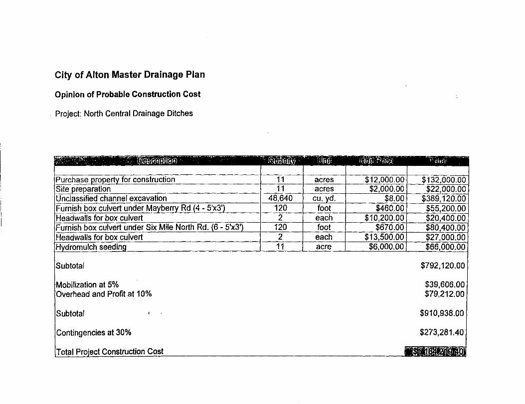
City of Alton Master Drainage Plan
Opinion of Probable Construction Cost
. Project: North Central Drainage Ditches
Mobilization at 5% Overhead and Profit at 10%
Jr.nntinnencies at 30%
1-'rnrl'!r.t Construction Cost
$792,120.00
$39,606.00 $79,212.00
$910,938.00
$273,281.40
-~''I< "1" ~f.V.f'';"!>li07.1'ii'11 ·~\l.l-l~!~1t~! \:1 1~L

City of Alton Master Drainage Plan
Opinion of Probable Construction Cost
. Project: Northwest Drainage Ditch No 1
Subtotal
Mobilization at 5% Overhead and Profit at 1 0%
Subtotal
'1'\ntlnnencies at 30%
Construction Cost r
$744,640.00
$37,232.00 $74,464.00
$856,336.00
$256,900.80
II$JE1nl.®mtl

City of Alton Master Drainage Plan
Opinion of Probable Construction Cost
Project: Northwest Drainage Ditch No. 2
Subtotal
Contingencies at 30%
1-'rnu~r.t Construction Cost
$170,600.00
$8,530.00 $17,060.00
$196,190.00
$58,857.00

City of Alton Master Drainage Plan
Opinion of Probable Construction Cost
Project: West Central Drainage Ditch
Mobilization at 5% Overhead and Profit at 1 0%
Subtotal
Contingencies at 30%
Drniol"t Construction Cost
$484,240.00
$24,212.00 $48,424.00
$556,876.00
$167,062.80

City of Alton Master Drainage Plan
Opinion of Probable Construction Cost
Detention Basin: Louisiana Street
Subtotal
Mobilization at 5% Overhead and Profit at 10%
Subtotal
Contingencies at 30%
Construction Cost
$928,192.00
$46,409.60 $92,819.20
$1,067,420.80
$320,226.24
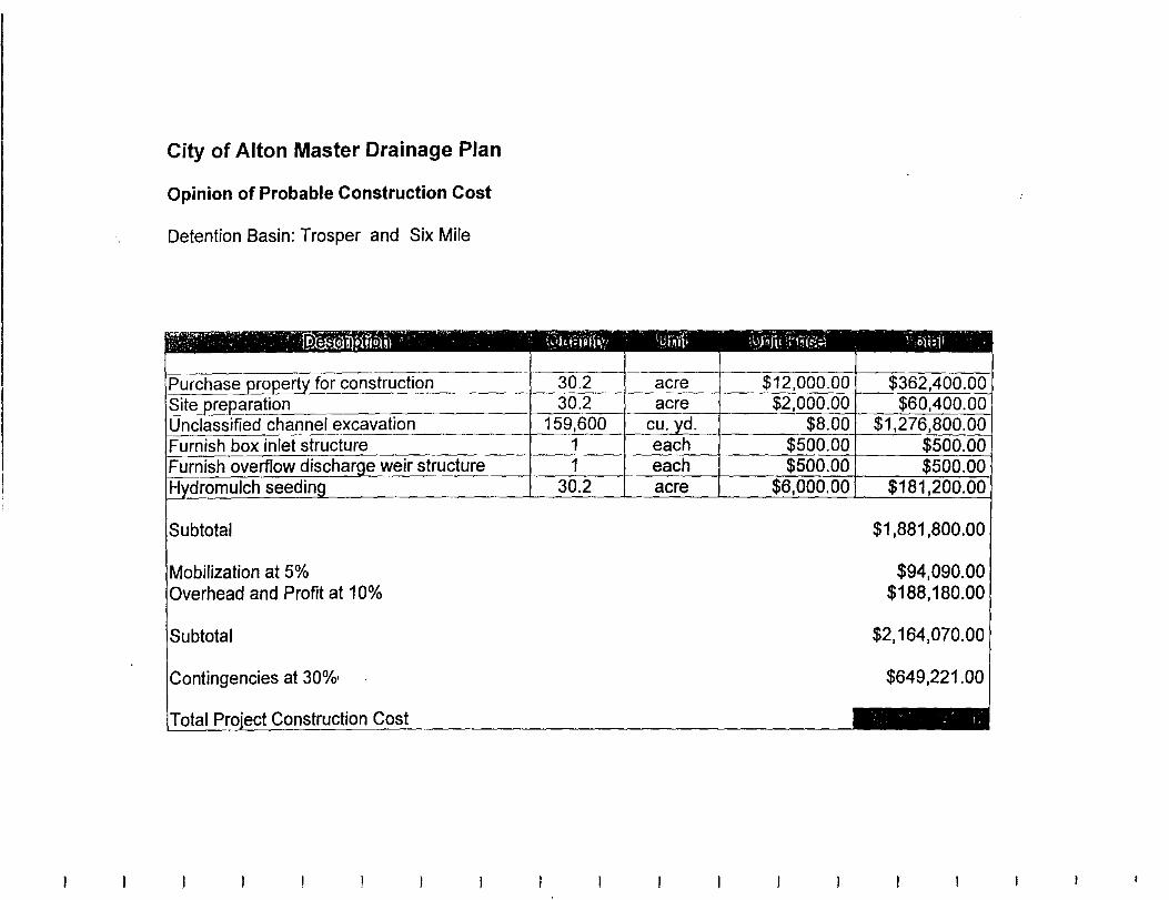
City of Alton Master Drainage Plan
Opinion of Probable Construction Cost
Detention Basin: Trosper and Six Mile
Subtotal
Mobilization at 5% Overhead and Profit at 1 0%
Subtotal
Prni"'r-t Construction Cost
$1,881,800.00
$94,090.00 $188,180.00
$2,164,070.00
$649,221.00

City of Alton Master Drainage Plan
Opinion of Probable Construction Cost
Detention Basin: Mayberry and Six Mile
!Mobilization at 5% )ll<>rhA~n and Profit at 10%
Prni~>rt Construction Cost
$962,200.00
$48,110.00 $96,220.00
$1,106,530.00
$331,959.00

City of Alton Master Drainage Plan
Opinion of Probable Construction Cost
Detention Basin: Bryan and Six Mile
Subtotal
Mobilization at 5% ead and Profit at 1 0%
Construction Cost
$743,500.00
$37,175.00 $74,350.00
$855,025.00
$256,507.50
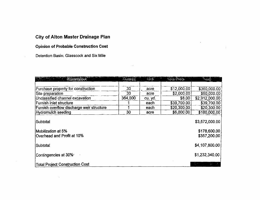
City of Alton Master Drainage Plan
Opinion of Probable Construction Cost
Detention Basin: Glasscock and Six Mile
!Mobilization at 5% '"~"rhP~rl and Profit at 10%
1-'rniP.r.t Construction Cost
$3,572,000.00
$178,600.00 $357,200.00
$4,107,800.00
$1,232,340.00
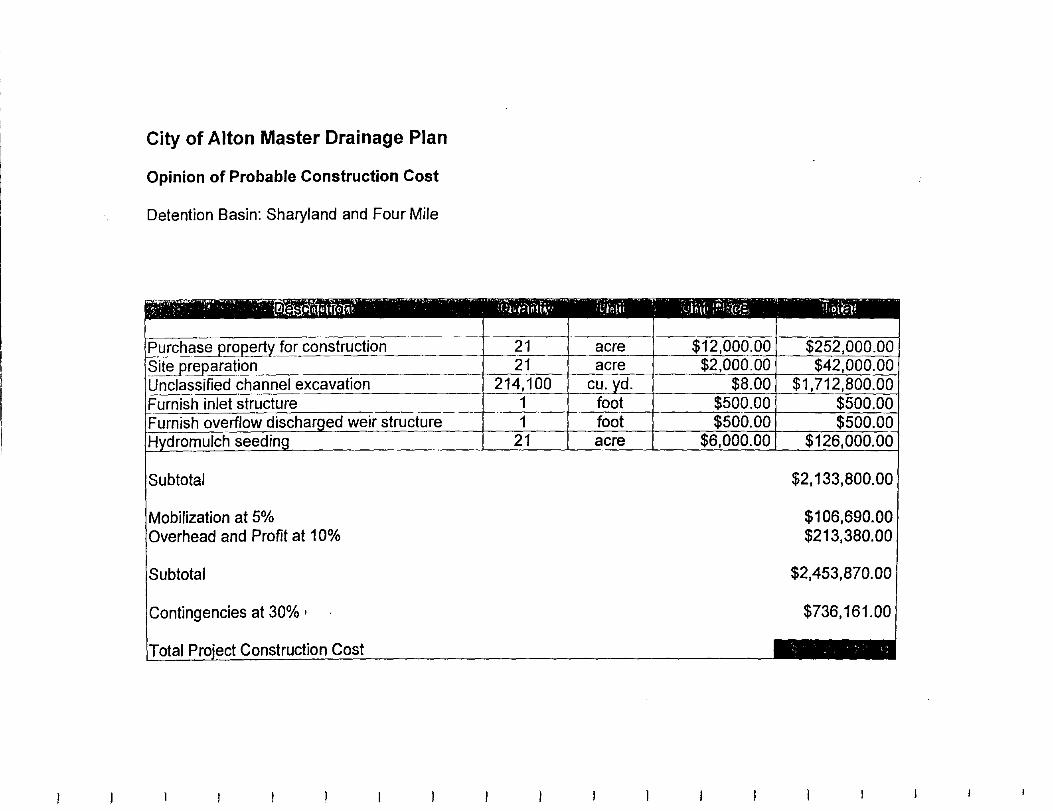
City of Alton Master Drainage Plan
Opinion of Probable Construction Cost
Detention Basin: Sharyland and Four Mile
Subtotal
Mobilization at 5% 111~rh~::~ri and Profit at 1 0%
Construction Cost
$2,133,800.00
$106,690.00 $213,380.00
$2,453,870.00
$736,161.00

City of Alton Master Drainage Plan
Opinion of Probable Construction Cost
Detention Basin: Los Ebanos and Six Mile
Subtotal
Mobilization at 5% Overhead and Profit at 10%
Subtotal
Contingencies at 30%·
Total Proiect Construction Cost
$900,400.00
$45,020.00 $90,040.00
$1,035,460.00
$310,638.00
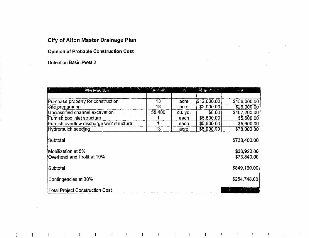
City of Alton Master Drainage Plan
Opinion of Probable Construction Cost
Detention Basin:West 2
Contingencies at 30%
Total Proiect Construction Cost
$738,400.00
$36,920.00 $73,840.00
$849,160.00
$254,748.00
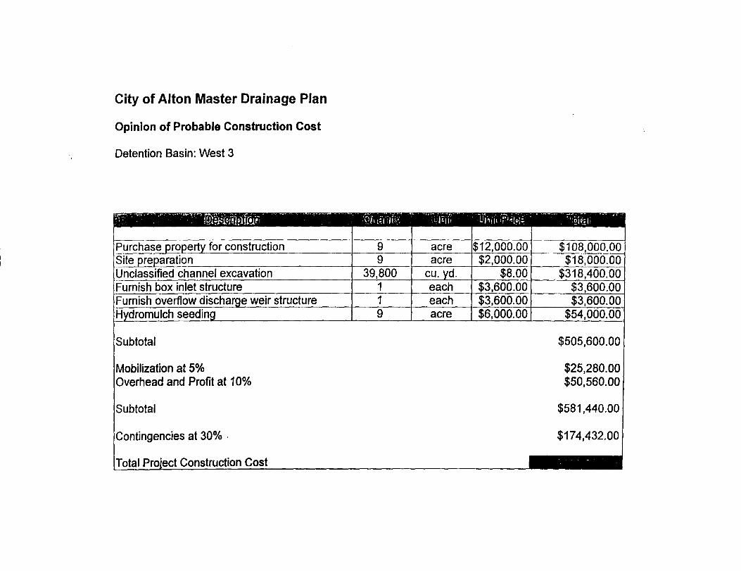
City of Alton Master Drainage Plan
Opinion of Probable Construction Cost
Detention Basin: West 3
Mobilization at 5% Overhead and Profit at 10%
Subtotal
Contingencies at 30% .
Cost
$505,600.00
$25,280.00 $50,560.00
$581,440.00
$174,432.00

City of Alton Master Drainage Plan
Opinion of Probable Construction Cost
Detention Basin:West 4
Subtotal
Mobilization at 5% rhead and Profit at 10%
Subtotal
Contingencies at 30% ·
Total Proiect Construction Cost
$671,800.00
$33,590.00 $67,180.00
$772,570.00
$231,771.00
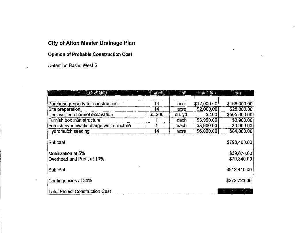
City of Alton Master Drainage Plan
Opinion of Probable Construction Cost
Detention Basin: West 5
Subtotal
Mobilization at 5% Overhead and Profit at 1 0%
Subtotal
Contingencies at 30%
Total Proiect Construction Cost
$793,400.00
$39,670.00 $79,340.00
$912,410.00
$273,723.00
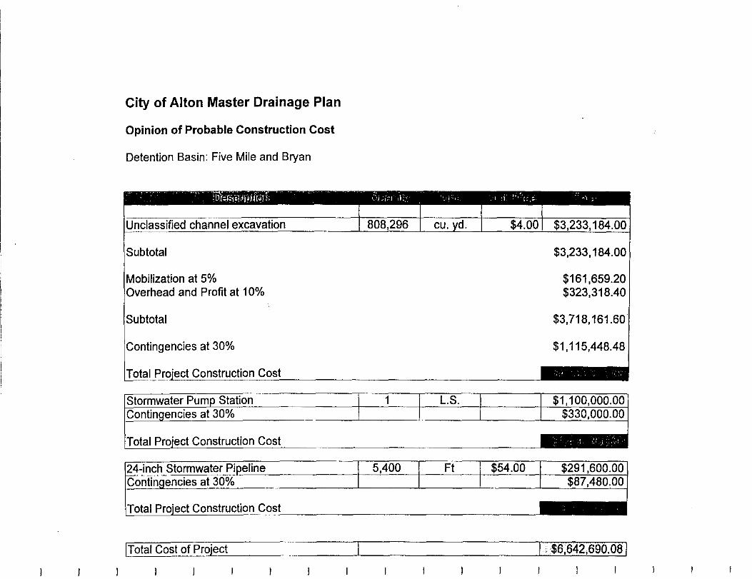
City of Alton Master Drainage Plan
Opinion of Probable Construction Cost
Detention Basin: Five Mile and Bryan
'nntinn<>ncies at 30%
Prni<>f't Construction Cost
Construction Cost
Total Proiect Construction Cost
$3,233,184.00
$161,659.20 $323,318.40
$3,718,161.60
$1,115,448.48
!Total Cost of Project r-- I $6,642,690.08/
APPENDIXC
Texas Water Development Board Review Comments for the City of Alton Flood Protection Planning Contract- Contract
No. 96-483-158 on the Final Draft Report

F'HOIIE 110. Jun. 24 1'3'37 11: 23At1 F'2
TEXAS WATER DEVELOPMENT BOARD
Willi.un 8. Madden. Chairm,:n Charle' W. ]enn<>30 ,\f.m:brr L;·non"<•od Sanders, Memb"
June 9, 1997
Mr. Salvador Vela Mayor, City of Alton P. 0. Drawer 9004 Alton, Texas 78572
Craig D. l'cderscn F.x~C'II.tit.•t Adminif:r.:tl'(lr
JUN 1 S 1991 N oe Fcrnande:, Vi<·.-Cimimutn Elaine M. Barron, M.D., 1"/'~'b"
Chari<>S I. Geren, l>frmbrr
Re: Review Comments for Draft Report Submitted by the City of Alton, TWDB Contract No. 96-483-158
Dear Mr. Vela:
Staff members of the Texas Water Development Board have completed a review of the dr.aft ·. report under 1'WD8 Contract No. 96-483-1-58. As stated in the above referenced contrac(the City will consider incorporating comments from the EXECUTIVE ADMINISTRATOR shown in Attachment 1 and other com mentors on the draft final report into a final report. The. City must include a copy of the EXECUTIVE ADMINISTRATOR's comments in the final report. ··
The Board looks forward to receiving one (1) unbound camera-ready original and nine (9) bound double-sided copies of the Fmal Report on this planning project. Please contact Mr. Alfredo Rodriguez, the Board's Contract Manager, at (512) 463-7987, if you have any questions about the Board's comments. ·
Sincerely,
o wles ~.,.,...eputy Executive Administrator
-for Planning
cc:. Alfredo RodrigtJez, TWDB
Our.~i.tsion
!!:Jxn.·iJ<'kadcJ·Jhip in r/.1~ ~·omava&irJil Jtmf ttJprJmihl~ rkl'cWpm(tU •if'""''·.ra fr::Jr,:uz:ci j?il il;~ bttJcflt •if'thr ,.-,·~.l-.,.&llJ·, ct:mu)mJ. um .. ' t::rltJJ'tvTime11l11[1'"atU.
1'.0. Box 1.3231 • 1700 ~- Congrcs~Avcnuc • Atmin, Tcx"' i!l;"ll-3231 Telephone (51.!) 46.3-7847 • TdefJ., (512) 475-2053 • l-300- REL-\.Y TX (for the hearing impaired)
URL Address: lmp://www.twdb.>tate.rx.w • E-~:til Address: info@rwdb.>rate.tx.ll> $ Prinr.d on Recyd,d P•p•r @
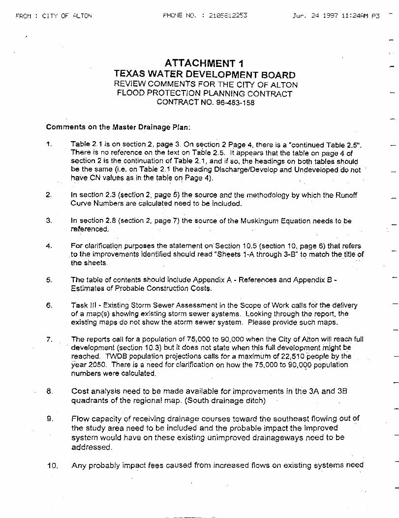
FROM CITY OF ALTON PHONE I'JCI. 2105812253 Jun. 24 19'37 11:24HM P3
ATTACHMENT 1 TEXAS WATER DEVELOPMENT BOARD REVIEW COMMENTS FOR THE CITY OF ALTON FLOOD PROTECTION PLANNING CONTRACT
CONTRACT NO. 96-483-158
Comments on the Master Drainage Plan:
1. Table 2. 1 is on section 2, page 3. On section 2 Page 4, there is a "continued Table 2.5". There is no reference on the text on Table 2.5. It appears that the table on page 4 of section 2 is the continuation of Table 2. 1 , and if so, the headings on both tables should be the same (i.e. on Table 2. 1 the heading Discharge/Develop and Undeveloped do not have CN values as in the table on Page 4).
. ' . .
2. In section 2.3 (section 2, page 5) the source and the methodology by which the Runoff Curve Numbers are calculated need to be included.
3. In section 2.8 (section 2. page 7) the source of the Muskingum Equation needs to be referenced.
4. For clarification purposes the statement on Section 10.5 {section 10, page 6) that refers to the improvements identified should read "Sheets 1-A through 3-8" to match the title of the sheets.
5. The table of contents should include Appendix A - References and Appendix 8 -Estimates of Probable Construction Costs.
6. Task Ill - Existing Storm Sewer Assessment in the Scope of Work calls for the delivery of a map(s) showing existing storm sewer systems. Looking through the report, the existing maps do not show the storm sewer system. Please provide such maps.
7. The reports call for a population of 75,000 to 90,000 when the City of Alton will reach full . development (section 1 0.3) but it does not state when this full development might be .
reached. 1WDB population projections calls for a maximum of 22,510 people by the year 2050. There is a need for clarification on how the 75,000 to 90,000 population numbers were calculated. -
8. Cost analysis need to be made available for improvements in the 3A and 38 quadrants of the regional map. (South drainage ditch)
9. Flow capacity of receiving drainage courses toward the southeast flowing out of the study area need to be included and the probable impact the improved system would have on these existing unimproved drainageways need to be addressed.
10. Any probably impact fees caused from increased flows on existing systems need
PHOHE 1~0. J,.;n. 24 1997 11: 24AM P4
to be addressed, especially to the southeast and out of the study area.
11. In the Scope of Work, flow and holding capacity evaluations need to be included in the report, particularly when in Table 2.1 Developed Discharges exceed Hidalgo County DO #1 flow capacities.
12. In the Scope of Work, the evaluation of the system's outlet points into the Hidalgo county Drainage District's system need to be included in the report, particularly when in Table 2,1 Developed Discharges exceed the DO's flow capacities.
13. An analysis of the 100-year storm event comparisons need tobe included in the ~0~ ..
14. Identifiable non-structural alternatives need to be included in the report.
15. In the Scope of Work, evaluation of alternatives on economic feasibility, safety considerations, environmental concerns and aesthetics need to be included in the report.·
16. Onsite detention should have been one non-structural alternative evaluated.
Comments on the Drainage Design Manual:
1. The definition of Swales on Appendix B needs to be included.
2. Computation Sheet 5-1 needs to be included.
3. On Table 5-5 the meaning of R-20, R-12.5. CBD, PO, HCO, etc, need to be included.
4. Computation Sheet 7-2 has 23 columns, there is an explanation for columns 1 through 14, but the explanations for .columns 15 through 22 are missing and need to be · included. All other Computation sheets within the manual are fully explained. . . . ' ' .,
5. Appendices D, E, and F, missing from the manual need to be included.

-- , ... Jun. 24 1'3'37 11: 25Rt1 P5
ATTACHMENT 2 TEXAS NATURAL RESOURCE CONSERVATION COMMISSION
REVIEW COMMENTS FOR CITY OF ALTON FLOOD PROTECTION PLANNING CONTRACT
CONTRACT NO. 96-483-158
1. An Application for Approval of Reclamation Project need not be filed with the Texas Natural Resource Conservation Commission for the referenced proposal. It was determined from our review that the prop9sed project, since it is in the City of Alton, needs to be permitted by the City. The City of Alton by virtue of its · participation in the National Flood Insurance Program, and in accordance with Section 16.236 {d) (3&4) of the Texas Water Code, has approval authority for the project. If the City has not already done so, they should insure that the proposed construction is documented and permitted in accordance with their Flood Hazard Prevention Ordinance. This documentation should also be submitted by the City to the Federal Emergency Management Agency to obtain a Letter of Map Revision (LOMR) of Alton's F~ood Insurance Rate Map.
2. The technical content of the referenced report is based on acceptable hydrological and hydraulic methods and is complete. Therefore, the merits of the proposed project can be evaluated from the report.
Responses to Texas Water Development Board Comments
on Final Draft Report
Comments on the Master Drainage Plan:
I. Concur
2. Concur
3. Concur
4. - Concur
5. Concur
6. The map of the existing storm sewer systems as required in Task III- Existing Storm Sewer Assessment in the Scope of Work has been developed and furnished as a separate document. A large scale map of the developed area of the city is required to show the existing storm sewer system.
7. The full development population range was developed by assuming five to six dwelling units per acre and four persons dwelling unit.
8. The improvements in the 3A and 3B quadrants are within the City ofPalmhurst. Their cost will not be the responsibility of the City of Alton.
9. The evaluation of the flow capacity of the receiving drainage courses toward the southeast is not inc! uded in the Scope of Work. Coordination meetings were held with the City of McAllen so that they would be informed about the proposed plans.
10. Not included in the Scope of Work.
11. Numerous attempts were made to coordinate with Hidalgo County Drainage District No. I. The capacity of their existing system is approximately a 10-year frequency storm. Hidalgo County Drainage District No. 1 currently has consultants evaluating improvements to its system. A meeting was held with the District's consultant to make them aware of the City
of Alton Master Drainage Plan.
12. See response to number 11.
13. The drainage system was evaluated in the study and presented in the report.
14. Non-structural alternatives are discussed in Section 3.
15. Discussions on economic feasability, safety considerations, environmental concerns and aesthetics are included in Section 9.
16. A future detailed land use plan does not exist for the City of Alton. The level of detail possible in establishing the runoff characteristics of the contributing watersheds can only be on an average basis. The proposed approach to watershed management is to permit the land developer to evaluate and proposed alternatives, including on-site detention, that achieve the prescribed level in the most economical matter.
Comments on the Drainage Design Manual
1. Concur
2. Concur
3. Concur
4. Explanations for columns 15 through 22 are included on Section 7, Page 6.
5. Appendices D, E, and F have been included in the manual.
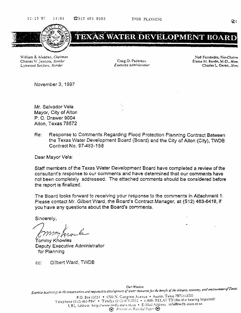
11-13'97 1-1:0-1 '0'.312 46:3 939.1 TIIDB PU:i:\I:\G
- .: . _":... . - ' . · . . _- . - .- ,TEXA:S.~WAT-ER))EVELOPMENT BOARD . . . - . . . . _ -------=--~
William B. Madden. Chairman Charl.:s W.Jenncss, ,lf,-mb,·r L ynwcad Sanders . .lh-r.~r
November 3, 1997
Mr. Salvador Vela Mayor, City of Alton P. 0. Drawer 9004 Alton, Texas 78572
Craig D. Pedersen E.:ue~t~.:t :\dminis~·rator
No~ F ernhdez, Vice-CI:airm Elaine M. Barr6n, M.D., ,1f,m1
Charles L. Geren,.!{(.-,,
Re: Response to Corr.ments Regarding Flood Protection Planning Contract Between the Texas Water Development Board (Board) and the City of Alton (City), TWOS Contract No. 97-483-158
Dear Mayor Vela:
Staff members of the Texas Water Development Board have completed a review of the consultant's response to our comments and have determined that our comments have not been completely addressed. The attached comments should be considered before the report is finalized.
The Board looks forward to receiving your response to the comments in Attachment 1. Please contact Mr. Gilbert Ward, the Beard's Ccntiact Manager, at (512) 463-6418, if you have any questions about the Board's comments.
Sincerely,
·1 L- 7 ,..-, ~ ..,~ £. . . n Y.- · ;.t·t-u?:---&-Tommy Knowles Deputy Executive Administrator
for Planning
cc: Gilbert Ward, TvVDB

U:O~ '0'512 ~63 9593 TIID!3 PU\\ I.\G
ATTACHMENT 1 TEXAS WATER DEVELOPMENT BOARD
RESPONSE COMMENTS FOR THE CITY OF ALTON FLOOD PROTECTION PLANNING CONTRACT
CONTRACT NO. 97-483-158
1. Your response to lVVDB comment #1 is not complete. Table 2.1 is continued from page 3 to page 4, but the headings on the columns are not the same. Also, it shculd be clear by locking at the table (by column headings) that the table compares calculated discharge's from SCS methodology to calculated discharges by HCDD#1 (which methods were used by HCDD#1 ?).
2. On page 4, portion of Table 2.1, what does the 02 after Drainage District No. 1 in column heading mean?
3. Response to TVVDB comment #2 -the source and methodology for Runoff Curve No. discussion was added, but the reference was not added to the List of References in Appendix A.
4. Your response to lVVDB comment #3 was not what we desired. It appears that nearly all of Section 2.8 is taken from "Hydrology for Engineers" by Linsley, Kohler and Paulus (2nd ed, copyright date 1975, Section 9-8, page 300). The text should be denoted as a quotation and prop<:!rly cited. other..vise it cculd be construed as plagiarism.
5. Please include the formula \Nhich introduces the cor.stant Kin the storage equation.
6. Eagle Point software, Watershed Modeling Manual needs to be included in the List of References.
7. TxOOT Drainage Manual needs to be incluced in the List of References.
8. It is assumed that the last sentence of Section 2.3 is citing that the Curve Number Values used by Eagle Point came originally from a SCS document, Section 4-Hydrology. Tf:is is not clear and net properly citec (and not in the List of References).
9. Respor1se to IWDB comment #6 - the map provided of Existing Drainage Facilities has no legend.
10. Response to lVVDB comment #13- as defir.ed in the Scope of Work for Task Ill, Subtask 6, develop analysis of the 1 00-year storm event and compare to FEMA !r"Jsurance Rate Maps. Your response states that the 100-year st·:xm event was evaluated, but the ev:J.it.:ation or a comparison to FEMP.. maps cannot be located in the reoort. Please note wr,ere in t!-.a re::JO::·rt this is performed. . .
14Joc.

Responses to Texas Water Development Board on Final Report
Comments on the Master Drainage Plan:
I. Concur.
2. Concur.
3. Modified as requested.
4. Modified as requested.
5. Modified as requested.
6. Modified as requested.
7. Modified as requested.
8. Modified as requested.
9. The map will be modified as requested.
I 0. The drainage system concept proposed in the study was sized to accommodate the I 00-year frequency storm. The FEMA FIRM Flood Insurance Rate Map for the unincorporated area of Hidalgo County around the City of Alton only contains Zone A designated areas in the form of depressed areas in the ground surface. The FEMA explanation of Zone A is "Areas of 1 00-year flood; base flood elevation and flood hazard factors not determined." In the consultants opinion, a detailed comparison in the report of the proposed drainage-ditch system to the FEMA approximate 1 00-year flooded areas would not add to the understanding and value of the Master Plan. Many of these depressed areas were incorporated into the drainage ditch routes and the detention storage areas.
11. New comment from TWDB. Section 3 has been reorganized as requested by the TWDB.
12. New comment from TWDB. Section 3 has been reorganized as requested by the TWDB.


