The following is a brief overview of the La Alma/Lincoln Park neighborhood context. The brief narrative and accompanying diagram is gleaned from the Lincoln Park Neighborhood Assessment -June 2006, on-site observations and resident interviews.
The La Alma/Lincoln Park Neighborhood is a distinctive and vibrant mixed use community. Lincoln Park is one of Denver’s oldest neighborhoods, characterized by a diversity of housing types, many of historical significance.
The neighborhood is landlocked by major transportation routes. It is bounded by Colfax Avenue to the north; 6th Avenue to the south; Speer Boulevard along the east edge; and contained to the west by the railroad tracks and Burnham Yard.
The neighborhood is in close proximity to the Central Business District and the Auraria Higher Education Center located to the north. The 10th and Osage RTD station is an important asset and benefit to the neighborhood. Lincoln Park also benefits from a number of parks, open space and recreational facilities. These include the Sunken Gardens, Lincoln Park, (a major park which is larger in area than the Denver Civic Center Park) and the La Alma Recreation Center located at the south end of the Park.
In addition, there are a number of open spaces that are associated with schools in the neighborhood. The Cherry Creek and Platte River bike paths also provide recreational opportunities.
Other public facilities include Byers Library,
Colorado Charter High School, west of Lincoln Park
La Alma Recreation Center, Lincoln Park
10th and Osage Light Rail Station
Santa Fe Drive
LINCOLNPARK
SUNKEN GARDENS
PARK
COLFAX AVENUE
WEST 13TH AVENUE
WEST 11TH AVENUE
WEST 9TH AVENUE
MA
RIP
OSA
ST.
OSA
GE
ST.
LIPA
N S
T.
KA
LAM
ATH
ST.
SAN
TA F
E D
RIV
E
WEST 8TH AVENUE
MULTI-FAMILY RESIDENTIAL
PRIMARILY SF AND DUPLEX RESIDENTIAL
RETAIL
COMMERCIAL LOW DENSITY
ACADEMIC
OPEN SPACE OR PARK
INDUSTRIAL/WAREHOUSE
2SOUTH LINCOLN REDEVELOPMENT MASTERPLANDates and sub head info here
West High School, Greenlee Elementary School, Colorado Charter High School and Denver Health Medical Center and Hospital. Additionally, there are a number of cultural facilities in the area such as the Denver Civic Theater and Museo de las Americas.
Denver Inner City Parish (DICP), on Mariposa Street across from Lincoln Park, is a community service provider for low-income residents, and has been providing basic human and educational needs since 1961. DICP also runs La Academia, a private, non-profit school grades six to twelve, as well as an Adult Night School program in their facility on Galapago Street.
The Santa Fe Drive Arts District is a major contributor to the dynamic character of the neighborhood. The district is a city wide/regional visitor draw. It is a commercial/retail corridor comprised of many art galleries, restaurants, retail stores, cultural events and nightlife.
Kalamath Street and Santa Fe Drive, a one-way couplet, is the major north/south traffic corridor through the neighborhood. Mariposa Street is a wide north/ south corridor within the neighborhood. Coflax, 13th, 8th and 6th Avenues are the major east/west corridors. Although walking distances within the neighborhood are not great, the perception is that distances are far, due to the fact that many of the aforementioned streets are wide, carry high volumes of traffic at higher speeds than neighborhood streets, and not very safe to cross.
Existing Land Use
SITE: South Lincoln Homes (DHA)
10th and Osage Street Station
Lincoln Park
Sunken Gardens
West High School
Speer Blvd
Auraria High Ed. Center
Colorado Convention Center
Kal
amat
h St
reet
Sant
a Fe
Driv
e
Colfax Ave
13th Ave
10th Ave
8th Ave
6th Ave
DENVERHOUSINGAUTHORITYT H E B U S I N E S S O F H O U S I N G .
III.3SOUTH LINCOLN REDEVELOPMENT MASTER PLANJanuary 2010 Final Master Plan Report
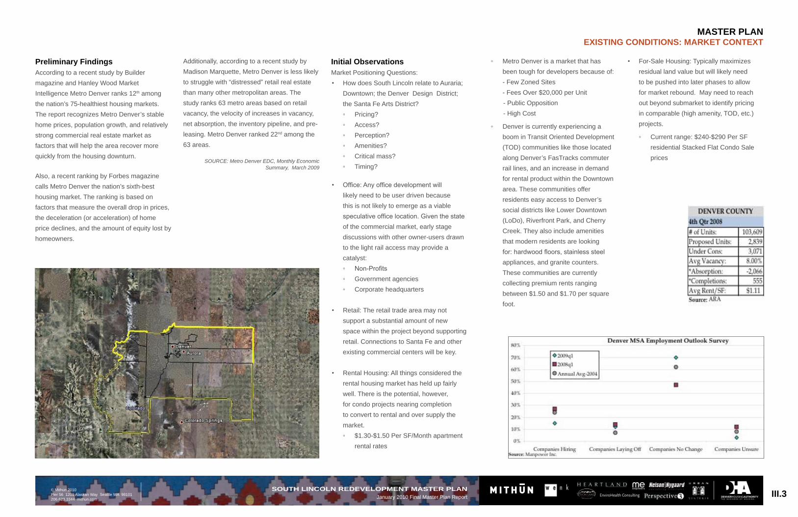
Preliminary FindingsAccording to a recent study by Builder magazine and Hanley Wood Market Intelligence Metro Denver ranks 12th among the nation’s 75-healthiest housing markets. The report recognizes Metro Denver’s stable home prices, population growth, and relatively strong commercial real estate market as factors that will help the area recover more quickly from the housing downturn.
Also, a recent ranking by Forbes magazine calls Metro Denver the nation’s sixth-best housing market. The ranking is based on factors that measure the overall drop in prices, the deceleration (or acceleration) of home price declines, and the amount of equity lost by homeowners.
Initial ObservationsMarket Positioning Questions:
How does South Lincoln relate to Auraria; • Downtown; the Denver Design District; the Santa Fe Arts District?
Office: Any office development will • likely need to be user driven because this is not likely to emerge as a viable speculative office location. Given the state of the commercial market, early stage discussions with other owner-users drawn to the light rail access may provide a catalyst:
Retail: The retail trade area may not • support a substantial amount of new space within the project beyond supporting retail. Connections to Santa Fe and other existing commercial centers will be key.
Rental Housing: All things considered the • rental housing market has held up fairly well. There is the potential, however, for condo projects nearing completion to convert to rental and over supply the market.
$1.30-$1.50 Per SF/Month apartment ◦rental rates
La Alma Recreation Center, Lincoln Park
10th and Osage Light Rail Station
Santa Fe Drive
Additionally, according to a recent study by Madison Marquette, Metro Denver is less likely to struggle with “distressed” retail real estate than many other metropolitan areas. The study ranks 63 metro areas based on retail vacancy, the velocity of increases in vacancy, net absorption, the inventory pipeline, and pre-leasing. Metro Denver ranked 22nd among the 63 areas.
SOURCE: Metro Denver EDC, Monthly Economic Summary, March 2009
Metro Denver is a market that has ◦been tough for developers because of: - Few Zoned Sites - Fees Over $20,000 per Unit- Public Opposition - High Cost
Denver is currently experiencing a ◦boom in Transit Oriented Development (TOD) communities like those located along Denver’s FasTracks commuter rail lines, and an increase in demand for rental product within the Downtown area. These communities offer residents easy access to Denver’s social districts like Lower Downtown (LoDo), Riverfront Park, and Cherry Creek. They also include amenities that modern residents are looking for: hardwood floors, stainless steel appliances, and granite counters. These communities are currently collecting premium rents ranging between $1.50 and $1.70 per square foot.
For-Sale Housing: Typically maximizes • residual land value but will likely need to be pushed into later phases to allow for market rebound. May need to reach out beyond submarket to identify pricing in comparable (high amenity, TOD, etc.) projects.
Current ◦ range: $240-$290 Per SF residential Stacked Flat Condo Sale prices
DENVERHOUSINGAUTHORITYT H E B U S I N E S S O F H O U S I N G .
EnviroHealth ConsultingIII.4SOUTH LINCOLN REDEVELOPMENT MASTER PLANJanuary 2010 Final Master Plan Report
1000 block of Navajo Street, looking north to the La Alma Recreation center
The Denver Housing Authority’s South Lincoln Park Homes neighborhood provides affordable housing for low- to moderate-wage earners. The development, built in 1954, is comprised of 39 two story brick buildings. The 15.1 acre property includes 270 affordable units (254 occupied), translating to 17 dwelling units per acre. The photos to the right show the character and style of the residents.
As part of the preparation of the South Lincoln Redevelopment Master Plan, the design team analyzed the wet utilities located at the South Lincoln Homes neighborhood and noticed that the site contains obsolescence of major systems at the existing conditions.
Based on the current regulations from Denver Wastewater’s “Storm Drainage Design and Technical Criteria Manual,” the storm sewer is to be able to convey the 5-year storm with minimum disruption to the urban environment and also required to implement Best Management Practices (BMPs) to control the water quality of storm-generated runoff. At the current conditions, neither of these requirements are met.
There is currently no implementation of any water quality BMPs, and the public storm sewer system is undersized and cannot convey the 5-year storm without causing flooding issues. Currently, the RTD station located at 10th and Osage is prone to flooding due to the inadequate storm sewers at this location. Outreach conversations with residents yielded consistent concern about this problem.
With the proposed South Lincoln Redevelopment, we will be able to provide both water quality practices and onsite detention that allows for a gradual release into the storm system. This will allow for the existing storm system to be utilized without continually having the 5-year storm flood the site. This will also allow for the current concerns with the RTD station flooding to be alleviated.
The current sanitary sewer design meets regulations from Denver Wastewater’s “Sanitary Design and Technical Criteria Manual;” however, the current layout of the sanitary sewer poses some issues with maintenance. Some of the blocks in the South Lincoln Redevelopment do not have alleys running through them, thus creating a sanitary sewer that runs between housing units and having manholes that aren’t easily accessible to maintenance vehicles.
The South Lincoln Homes neighborhood further meets the definition of physical distress, in regard to wet utilities. The increased density of the redevelopment will require upgrades to major utilities which include potable water, storm sewer and sanitary sewer.
The Master Plan advocates and outlines the improvements to be made, thus alleviating all the issues and concerns mentioned above.
MASTER PLANExISTING CONDITIONS: ExISTING UTILITIES AT SOUTH LINCOLN HOMES
DENVERHOUSINGAUTHORITYT H E B U S I N E S S O F H O U S I N G .
III.5SOUTH LINCOLN REDEVELOPMENT MASTER PLANJanuary 2010 Final Master Plan Report
A Neighborhood on the MoveIn order to achieve the goals of this Master Plan, the transportation network serving the South Lincoln Homes and the surrounding La Alma/Lincoln Park neighborhood must be reconceived and redesigned. Meeting the mobility needs of existing residents and accommodating travel by future residents will require that emphasis is placed on:
Reducing vehicle speeds; a. Improving pedestrian safety b. (especially at crossings);Enhancing neighborhood-serving c. transit service; Making it easier for residents of all d. ages and abilities to get around by bike.
This section summarizes recommended improvements to the transportation system serving the South Lincoln Homes redevelopment site and surrounding neighborhood. These proposals are intended to accommodate all modes, including private automobiles, transit buses, bicycles, and pedestrians as well as service vehicles, snow plows, and emergency response vehicles. Proposed improvements have the potential to not only provide benefits to existing South Lincoln Homes residents (including better public health outcomes, reduced risk of pedestrian and bicycle collisions, and enhanced economic opportunity through expanded mobility choices), but to also provide benefits to residents of the surrounding neighborhood.
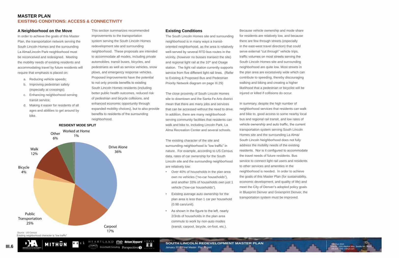
Source: US CensusExisting neighborhood character is “low traffic”
Drive Alone36%
Bicycle4%
Walk12%
Other6%
Worked at Home1%
Resident Mode Split
Carpool17%
Public Transportation
25%
4%
RESIDENT MODE SPLIT
Existing ConditionsThe South Lincoln Homes site and surrounding neighborhood is in many ways a transit-oriented neighborhood, as the area is relatively well-served by several RTD bus routes in the vicinity, (however no busses transect the site) and regional light rail at the 10th and Osage station. The light rail station currently supports service from five different light rail lines. (Refer to Existing & Proposed Bus and Pedestrian Priority Network diagram on page III.29)
The close proximity of South Lincoln Homes site to downtown and the Santa Fe Arts district mean that there are many jobs and services that can be accessed without the need to drive. In addition, there are many neighborhood-serving community facilities that residents can walk and bike to, including Lincoln Park, La Alma Recreation Center and several schools.
The existing character of the site and surrounding neighborhood is “low traffic” in nature. For example, according to US Census data, rates of car ownership for the South Lincoln site and the surrounding neighborhood are relatively low:
Over 40% of households in the plan area • own no vehicles (“no-car households”), and another 33% of households own just 1 vehicle (“low-car households”).
Existing average auto ownership for the • plan area is less than 1 car per household (0.98 cars/unit).
As shown in the figure to the left, nearly • 2/3rds of households in the plan area commute to work by non-auto modes (transit, carpool, bicycle, on-foot, etc.).
Because vehicle ownership and mode share for residents are relatively low, and because there are few through streets (especially in the east-west travel direction) that could serve external “cut through” vehicle trips, traffic volumes on most streets serving the South Lincoln Homes site and surrounding neighborhood are quite low. Most streets in the plan area are excessively wide which can contribute to speeding, thereby discouraging walking and biking and creating a higher likelihood that a pedestrian or bicyclist will be injured or killed if collisions do occur.
In summary, despite the high number of neighborhood services that residents can walk and bike to, good access to some nearby local bus and regional rail transit, and low rates of vehicle ownership and auto traffic, the current transportation system serving South Lincoln Homes site and the surrounding La Alma/South Lincoln Neighborhood does not fully address the mobility needs of the existing residents. Nor is it configured to accommodate the travel needs of future residents. Bus service to connect light rail users and residents to other services and amenities in the neighborhood is needed. In order to achieve the goals of this Master Plan (for sustainability, economic development, and quality of life) and meet the City of Denver’s adopted policy goals in Blueprint Denver and Greenprint Denver, the transportation system must be improved.
DENVERHOUSINGAUTHORITYT H E B U S I N E S S O F H O U S I N G .
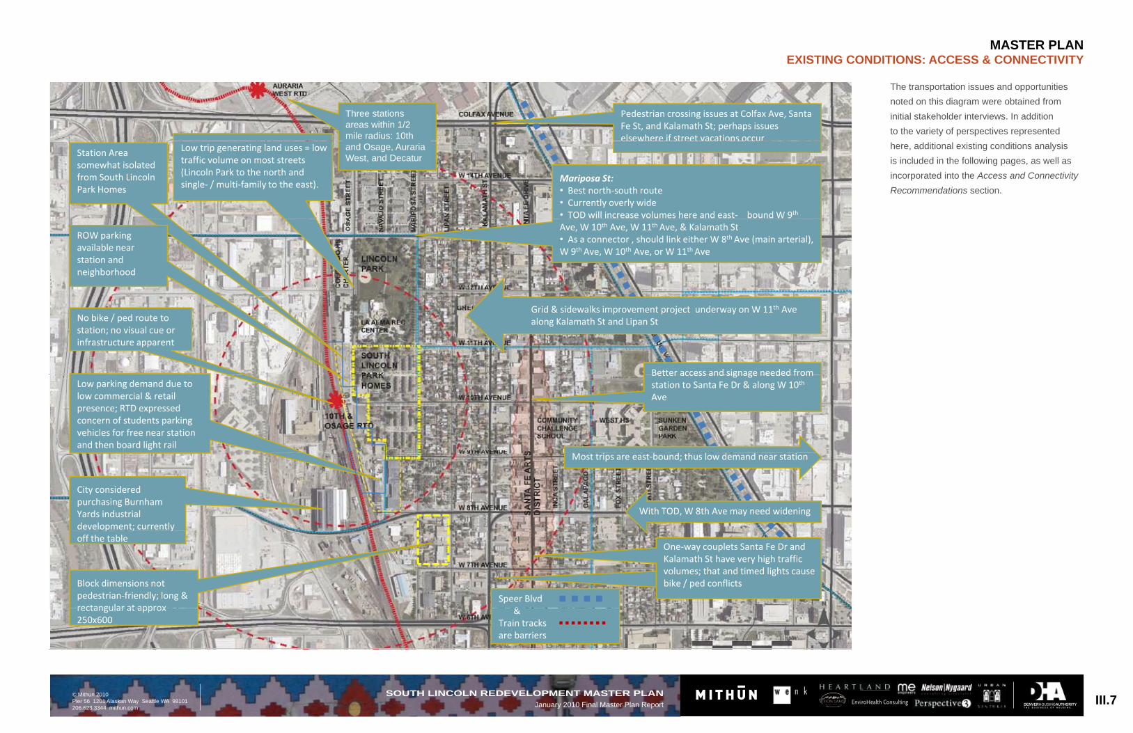
The transportation issues and opportunities noted on this diagram were obtained from initial stakeholder interviews. In addition to the variety of perspectives represented here, additional existing conditions analysis is included in the following pages, as well as incorporated into the Access and Connectivity Recommendations section.
III.7SOUTH LINCOLN REDEVELOPMENT MASTER PLANJanuary 2010 Final Master Plan Report
Pedestrian crossing issues at Colfax Ave, SantaFe St, and Kalamath St; perhaps issueselsewhere if street vacations occur
Three station areaswithin ½ mileradius: South
Station Areasomewhat isolatedfrom South LincolnPark Homes
Mariposa St:• Best north south route• Currently overly wide• TOD will increase volumes here and east boundW 9th
Low trip generating land uses = lowtraffic volume on most streets(Lincoln Park to the north andsingle / multi family to the east).
elsewhere if street vacations occurLincoln, AurariaWest, and Decatur
ROW parkingavailable nearstation andneighborhood
Ave, W 10th Ave, W 11th Ave, & Kalamath St• As a connector , should link either W 8th Ave (main arterial),W 9th Ave, W 10th Ave, or W 11th Ave
•
Better access and signage needed from
No bike / ped route tostation; no visual cue orinfrastructure apparent
Grid & sidewalks improvement project underway on W 11th Avealong Kalamath St and Lipan St
Low parking demand due tolow commercial & retailpresence; RTD expressedconcern of students parkingvehicles for free near stationand then board light rail
Better access and signage needed fromstation to Santa Fe Dr & along W 10th
Ave
With TOD, W 8th Ave may need widening
Most trips are east bound; thus low demand near station
City consideredpurchasing BurnhamYards industrialdevelopment; currentlyp ; yoff the table
Block dimensions notpedestrian friendly; long &rectangular at approx
One way couplets Santa Fe Dr andKalamath St have very high trafficvolumes; that and timed lights causebike / ped conflicts
Three stations areas within 1/2 mile radius: 10th and Osage, Auraria West, and Decatur
DENVERHOUSINGAUTHORITYT H E B U S I N E S S O F H O U S I N G .
EnviroHealth Consulting
Incorporating Health into the Planning ProcessAs part of the planning process, a public health consultant was engaged to work with the design team. A Health Impact Assessment (HIA) was conducted as part of the existing conditions analysis. The South Lincoln HIA is an expansive analysis which includes not only the South Lincoln Homes, but the broader South Lincoln neighborhood. This HIA was conducted concurrently with the Master Plan design, in approximately four months. Since the HIA is focused on an assessment of current conditions and future potential impacts from the redevelopment, the evidence-based research and recommendations are centered on potential changes to the built environment and less on policy considerations.
The goals of the HIA are to: Identify potential impacts the • redevelopment may have on health and wellbeing of the South Lincoln neighborhood;
Suggest ways to improve overall health • through evidence based health data and to assess potential human health risks; and
Provide specific recommendations for the • South Lincoln neighborhood through the redevelopment process.
The Healthy Development Measurement Tool (HDMT) checklist was used as the framework for this Health Impact Assessment. The HDMT was developed by the San Francisco Department of Public Health, and is a comprehensive evaluation metric to consider health needs in urban development plans and projects. HDMT represents a specific methodology, generated and validated to
use for multiple types of HIAs. The HDMT is organized into six categories of objectives, which include: Environmental Stewardship, Safe and Sustainable Transportation, Social Cohesion, Public Infrastructure (amenities and services), Adequate and Healthy Housing, and Healthy Economy. Through the HIA, broad health objectives were identified for South Lincoln Homes, and include the following (along with selected existing health data for adults only). The full HIA document, including existing conditions and recommendations, can be found in the Appendix.
Broad Health ObjectivesIncrease physical activity: Overweight/• obesity high among residents (55%)Improve pedestrian & bike opportunities • and safety: Very few residents exercise enough (28% exercise aerobically 3 or more times a week)
Increase opportunity for healthy eating: • Very few eat recommended daily allowances for fruits, vegetables and other fiber (only 13% have 5 or more servings of high fiber food)
Better access to health care: High • percentage of residents have above normal blood pressure; 41% are not Denver Health patients and 30% don’t have a medical home
Reduce crime and fear of crime: About • 50% of residents agree the community has shootings and violence; only 51% feel safe about being alone at night in neighborhood
Some• social cohesion: Some neighbors feel neighbors are willing to help if needed, and feel the neighborhood is close knit but 48% strongly or somewhat disagree that the neighborhood is good place to
AURARIA/ LINCOLN PARK DEMOGRAPHICS
Indicator 2000 Data
2007 Data
Total Population 6,554 6,315
Total Births* 149 93
% Births Non-Latino White*
11.41% 23.66%
% Births African-American*
6.71% 11.83%
% Births Latino* 77.18% 60.22%
% Birth Asian/Pacific Islander*
0% 4.30%
FAMILIES AND HOUSEHOLDS
Indi
cato
r
Aur
aria
- Li
ncol
n Pa
rk
Den
ver
Dat
a Ye
ar
Persons per House-hold
2.51 2.24 2006
%Children Living with Single Parents
52.1% 28.0% 2000
% Births to Unwed Mothers*
53.8% 33.2% 2007
raise children and 66% do not attend neighborhood association meetings
Improve• traffic safety: 65% do not have any type of motor vehicle; 54% take bus
Key Demographics of Auraria/ Lincoln Park NeighborhoodThe following data is from a larger area than the South Lincoln Homes site. The data is collected regularly by the Piton Foundation for the Auraria/ Lincoln Park area and can be used for comparison in future.
Labor and EmploymentOver half of the community (55%) have service type jobs, compared to Denver (36%) (2002
data).
Key Socioeconomic Data for Lincoln Park SchoolsSchools in this area continue to struggle to serve the needs of the children. For example,
The graduation rate is about 12%.•
About• 95% of students receive free and reduced lunches compared to greater Denver at 65%.
In • 7th grade, the majority of students are unsatisfactory or only partially proficient in math and reading at K-8 level.
POVERTY AND INCOME
IndicatorAuraria-Lincoln
ParkDenver Data Year
Average Household Income $38,480 $55,129 2000
% Persons in poverty 37.73% 14.29% 2000
% Children (under 18) in Poverty 51.04% 20.82% 2000
% Families in Poverty 37.05% 10.63% 2000
% Single Mothers with Children in Poverty 63.99% 32.58% 2000
% Households with Income less than 100% of Denver's Median Income
65.40% 49.90% 2000
% Asian and Pacific Islanders in Poverty 21.03% 16.83% 2000
Data source for demographic information above: The Piton Foundation
The Auraria - Lincoln Park neighborhood used for the Piton Foundation data. This area incorporates two census tracts, and is approximately 1240 acres. The South Lincoln Homes site, just over 1% of the neighborhood area at 15 acres, is central to this neighborhood.
South Lincoln Homes
III.8SOUTH LINCOLN REDEVELOPMENT MASTER PLANJanuary 2010 Final Master Plan Report
Conceptual Option A: 10th Avenue Promenade Conceptual Option B: Navajo Park Street Conceptual Option C: Green Street
Conceptual OptionsAs a result of input from the Steering Committee, the Housing Authority, and based on project goals and program, the design team created three conceptual options, A, B & C for redevelopment of South Lincoln homes. These options were presented to the community and residents at various public presentations and meetings. All options included the following core elements:
Street calming strategies along Mariposa • Street;Master Plan designed for a phased, • “checkerboard” sequence of construction, minimizing relocation and displacement; The first phases of new construction may include City of Denver parcels west of South Lincoln Homes;New Open Spaces and Parks to • compliment Lincoln Park
Draft Preferred Plan Final Preferred Plan
services, improve transportation access, and provide economic and job opportunities. The primary comments, along with others, will be addressed by DHA through community and supportive services and incorporated into the physical plan. Common themes and interest expressed to be part of the plan included: 10th Avenue as a key neighborhood ‘main street’ for pedestrians, bikes, and vehicles; provide a variety of open space and flexible community gathering spots, amenities for all ages, and improved safety and security.
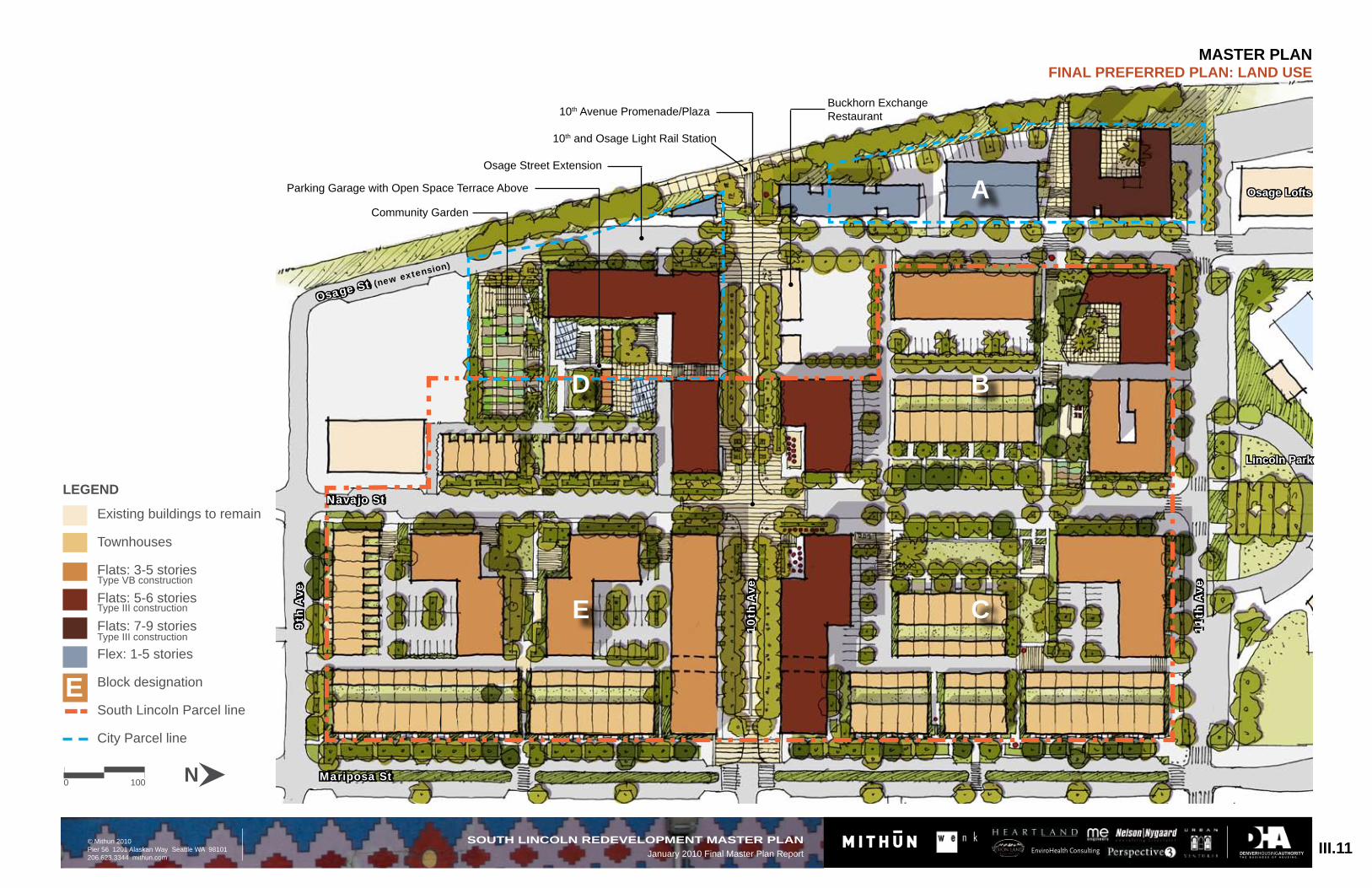
Final Preferred PlanThe Final Preferred Plan is focused around 10th Avenue, where the non-residential uses will make it an active street. It creates a promenade for a direct view to the light rail station, with art and sculpture to help with wayfinding. A public plaza provides flexible space for neighbors and visitors to gather, and
Transition in building scale to surrounding • residential and industrial areas;Enriched pedestrian experience along 10• th Avenue to Santa Fe Drive: safer, more interesting streetscape;Additional residents to enhance • environmental performance of the neighborhood;Mature landscape through retention of • healthy existing trees;Good Neighbor Streets: many eyes on the • street make safe, walkable environments.
Draft Preferred PlanThe Draft Preferred Plan incorporated the comments received from residents and stakeholders since the previous meeting. The comments the team heard most for the project vision included: provide site amenities, create a safe and secure place, replace existing units, provide neighborhood/community
could be closed to traffic for special occasions or festivals.
Family-friendly townhomes and lower buildings along Mariposa Street provide a transition to the historic neighborhood to the east. Open spaces have been designed to be publicly visible. Homes face the open spaces promoting passive surveillance and security.
The design also promotes safety by lining streets and sidewalks with front doors and stoops allowing for added ‘eyes on the street’. The emphasis is on ‘green streets’ with new tree plantings and comfortable sidewalk widths to encourage walking, making it easier to meet neighbors and provide better access to community amenities. Designated bike routes are delineated providing access to Cherry Creek and the Platte River trails.
III.9SOUTH LINCOLN REDEVELOPMENT MASTER PLANJanuary 2010 Final Master Plan Report
DENVERHOUSINGAUTHORITYT H E B U S I N E S S O F H O U S I N G .
EnviroHealth Consulting
The South Lincoln Homes Redevelopment Master Plan seeks to revitalize this community by enabling residents the opportunity to enjoy the unique advantages of a holistic, transit-oriented development realized through the core attributes established during the design process: a highly green mixed-use community, focused on a healthy lifestyle, increased non-auto mobility, an integration of the resource conservation and management systems, and a diverse mix of new and existing residents. The redevelopment Master Plan proposed new residential units in a mix of townhouses and multifamily flats (available for a mix of income levels). In addition to replacing the project based affordable housing and adding new housing, a mix of retail, commercial and community services locations are provided at the ground floor to encourage and promote activity along the streets. Likewise, the Master Plan weaves in outdoor amenities, including a new plaza and promenade, and a variety of open spaces, to enrich the neighborhood.
The design process began with our relationships with the residents and the community through an integrated outreach process that was open, thorough and goals oriented. Public input was critical to the success of the plan so residents, the neighborhood and local businesses and organizations had multiple opportunities to participate and comment on the redevelopment process and design. A Steering Committee was established of key leaders from each of these groups along with representatives from the City. This committee met several times throughout the process and helped direct
VI application. These goals were reviewed with the Steering Committee as one of the first tasks, and shared with the public at the first community meeting. These statements, and their development, were posted at each meeting to ground the discussion in the goals mutually agreed upon.
A health impact assessment was conducted to set a baseline for the residents and the community, to make recommendations to the design team. Using the needs assessment survey, administered by the DHA, and other health data available along with interviews with residents and health officials, the design team identified the key health concerns for the community. The research showed that the main health related issues are a need to increase physical activity; improve pedestrian, bike and traffic safety; improve access to health care; reduce crime and the fear of crime; and improve social cohesion.
The overall concept of the Master Plan creates pedestrian zones throughout the community that focus density within a mixed use environment, integrate natural and built features, provide a variety of passive and active open spaces, celebrate culture and community art and organize transportation and water management systems. The emphasis is on ‘green streets’ with new tree plantings along with tree preservation and comfortable sidewalk widths to encourage walking, making it easier to meet neighbors and provide better access to community amenities. Designated bike routes are delineated, providing access the Cherry Creek trail and the Platte River trails.
the design team toward a plan that met their various constituents’ needs. Open community meetings we held in conjunction with the Steering Committee meetings. At these events, the residents and the community were invited to learn about the progress of the plan and to provide feedback on all aspects of the design.
Along with the traditional outreach efforts, the design team conducted a Cultural AuditTM to gain insight into the DNA of the area. This process reaches out to residents and the community through one-on-one intercept interviews and scheduled interviews with local leaders and interested individuals. Those who could not participate in the community meetings, due to work schedule, or lack of interest in the public process, were given this opportunity to share their ideas and concerns.
Feedback, comments and concerns were documented and posted at the project office, located on the South Lincoln property, and on the DHA website. CulturalAuditTM feedback was gathered and assembled in an audio-visual piece shared with the community at the first public meeting.
After reviewing the work already completed for the Station Area Plan and the Neighborhood Plan, the design team assembled existing key focus areas and goals generated by the community as a starting point for the South Lincoln Redevelopment goals. The Denver Housing Authority supplemented these goals further with specific areas of concern for the development and the potential HOPE
The redevelopment is focused around 10th Avenue, where the non-residential uses combined with urban live/work units create an active street. The 10th Avenue promenade, lined with art and sculpture, intersects with Navajo Street to become the heart of the community and provides a clear connection from the light rail station to the Santa Fe Arts District. A public plaza provides flexible space for neighbors and visitors to gather, and could be closed to traffic for special community events or farmer’s markets.
The character of neighborhood streets weaves together the redevelopment with the surrounding community. Mixed use buildings along Osage Street provide space for community service centers, office, retail and high density residential uses. The extension of Osage Street to 9th Avenue reinforces pedestrian and bike circulation around the transit station, creating an active public realm. Navajo Street is predominantly lined with lower scale family homes and generous open spaces. Landscaped parks provide places for gathering and outdoor activity along with storm water management features such as raingardens. Family-friendly townhomes and lower scale buildings along Mariposa Street provide a transition to the historic neighborhood to the east. Open spaces have been designed to be publicly visible. Homes face the open spaces, promoting passive surveillance and security. The design promotes safety by lining streets and sidewalks with front doors and stoops. Along 11th Avenue, higher density residential buildings face existing Lincoln Park and the La Alma
Recreation Center and promote a more active use of the park itself. These buildings provide more “eyes on the street” adjacent to the park creating a safer environment.
Each area within the redevelopment functions as part of an integrated storm water system for the entire site. Contemporary storm water strategies provide site-wide storage, as opposed to individual parcel storage of storm water, as well as an onsite infiltration network. These recommended measures will require modification of existing standards but the benefits include a reduction of the overall impacts on the city water system, reduced maintenance and better long term performance. On site infiltration provides passive site irrigation and reduces the demand of potable water as well as the total storage needs for the site.
District level energy strategies incorporate resource conservation programs and on site renewable energy generation. High performance building envelopes, Energy Star building standards and high efficiency heating and cooling systems will reduce consumption by 40%, benefitting the residents, DHA and HUD. An onsite, two megawatt photovoltaic system will offset up to 80% of the projected energy needs of the final community.
MASTER PLANFINAL PREFERRED PLAN: VISION NARRATIVE
III.10SOUTH LINCOLN REDEVELOPMENT MASTER PLANJanuary 2010 Final Master Plan Report
MASTER PLANFINAL PREFERRED PLAN: RESIDENTIAL PROGRAM - “ON-SITE”
* does not include off-site Project-Based Affordable Housing Units.
The Master Plan includes a variety of open spaces throughout the redevelopment. This diagram indicates spaces which are intended as permanent open space easements to provide mid-block pathways for pedestrians as well as accommodating recreation and stormwater functions.
D1
D3 D2
E6
E1
E2
E4
E3
B4B3
B5 B1
B2
C4 C5
C1
C2C3
E5
D4
A1A2A3
DENVERHOUSINGAUTHORITYT H E B U S I N E S S O F H O U S I N G .
Use Goals & CharacterActivity should be visible from the • sidewalk; provide spaces for interaction like the plaza or outdoor seating
Spaces should be flexible to promote • community interaction and active participation
24• -hour spaces
Community• gathering spots: indoor and outdoor spaces. Sidewalks and streets can be people places too
Uses• should respond to the needs of current residents and new residents
Take• advantage of location near RTD, Lincoln Park, La Alma Recreation Center, and Santa Fe Arts District
Incorporate• art and education on history of neighborhood
LEGEND
C1
Non-residential use at ground floor
Parcel Number
A1A2A3
B1
B4
C4
D2
D1
III.15SOUTH LINCOLN REDEVELOPMENT MASTER PLANJanuary 2010 Final Master Plan Report
MASTER PLANFINAL PREFERRED PLAN: NON-RESIDENTIAL & COMMUNITY SERVICES
NON-RESIDENTIAL USES
Parcel Phase Community Service Potential uses Retail/
Commercial Potential Uses
A1 I 18,000 sf Senior center, shared computer lab, potential branch library kiosk/
resource center
n/a n/a
A2 VIII TBD TBD Office space
A3 VIII TBD Shared meeting rooms and computer lab (4K), potential
branch library/resource center
TBD
B1 IV 7,550 sf Community center, workforce training center (5K), Satellite
human services (1.5K)
n/a n/a
B4 II 2,000 sf Ombudsman (1.5K) and/or Relocation services
4,000 sf Coffee shop (1.5K), Laundromat (1.5K)
C4 III n/a n/a 13,500 sf Live/work storefronts, retail
D1 VI n/a n/a 7,200 sf Urban market/grocery
D2 II n/a n/a 7,200 sf Restaurant
DENVERHOUSINGAUTHORITYT H E B U S I N E S S O F H O U S I N G .
EnviroHealth Consulting
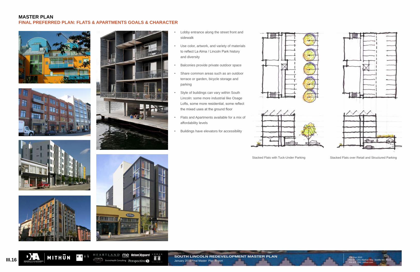
Stacked Flats with Tuck-Under Parking Stacked Flats over Retail and Structured Parking
Lobby entrance along the street front and • sidewalk
Use color, artwork, and variety of materials • to reflect La Alma / Lincoln Park history and diversity
Balconies• provide private outdoor space
Share• common areas such as an outdoor terrace or garden, bicycle storage and parking
Style• of buildings can vary within South Lincoln: some more industrial like Osage Lofts, some more residential, some reflect the mixed uses at the ground floor
Flats• and Apartments available for a mix of affordability levels
Buildings• have elevators for accessibility
III.16SOUTH LINCOLN REDEVELOPMENT MASTER PLANJanuary 2010 Final Master Plan Report
MASTER PLANFINAL PREFERRED PLAN: FLATS & APARTMENTS GOALS & CHARACTER
DENVERHOUSINGAUTHORITYT H E B U S I N E S S O F H O U S I N G .
Townhome with Tuck-Under GarageTownhome with Detached Garage/Carriage House
Entrance along the street front and • sidewalkPrivate planter or small garden in front• Express individual character with color, • materials and styleStoops, balconies and terraces provide • private outdoor space and interaction with neighborsTownhouses available for a mix of • affordability levelsWindows from inside the townhouse have • views to the street and to the backyard for security (“eyes on the street”)
III.17SOUTH LINCOLN REDEVELOPMENT MASTER PLANJanuary 2010 Final Master Plan Report
The redevelopment, which nearly triples the number of households on site, is focused on delivering exceptional environmental performance, enhancing the physical and social health of the community, and providing art and educational opportunities, including:
High performance Buildings and Neighborhood
Goal of LEED for Neighborhood • Development (LEED-ND), LEED for New Construction (LEED-NC), and Enterprise Green Communities Criteria
High performance buildings including: • Energy Star appliances, LED and florescent lighting, advanced controls, tankless water heaters, low flow plumbing fixtures, highly efficient HVAC systems, and solar water heating. Goal of 40% reduction in energy consumption.
As• the Master Plan is implemented, DHA established sustainability targets using LEED-ND, LEED-NC, Green Communities preferably above silver rating, for each component (buildings and systems) of the South Lincoln Redevelopment will be implemented.
Energy, Solar, and Heat Island Strategies
Reduction of Urban Heat Island Effect • and reduction of electrical and mechanical cooling system requirements is supported by minimizing pavement as well as an aggressive tree preservation strategy. Retaining exiting trees, while presenting site layout and underground utility placement challenges, has multiple
benefits. Designing the neighborhood with open spaces that include and celebrate existing trees establishes a strong sense of place, as well as avoids the water-intensive and risk-prone strategies of reliance on new tree plantings alone. Additional new tree plantings are also anticipated in the plan.
The plan balances development program • requirements with a set of strategies to take advantage of solar access. These include orienting the majority of new buildings for daylighting and passive winter solar gain. In addition, the distribution of lower and higher structures across the site is intended to provide solar access throughout.
At the rooftop level, the Master Plan • anticipates placement of photovoltaic arrays to meet 80% of the site’s anticipated electrical demand. This will have substantial reduction effects on GHG emissions from off-site coal-fired electric generation that would otherwise serve the site’s electrical needs.
Photovoltaic System with 2 mega-watts • of production to significantly lower energy consumption
PV arrays will be mounted on the roof ◦tops to achieve a maximum roof fill of 75% to achieve up to 80% of the building’s electrical load. The total site quantity of PV cells ~10,000 near 2MVA. The panels will be installed as the buildings are constructed per phase.
Geothermal system with district distribution • to lower operating costs by 50%
Each building footprint can have ◦geothermal wells drilled to support much of the building load. The open space within the site is an ideal location for wells to be installed. The plan is to also install the wells as the buildings are constructed per phase.
Stormwater Management that Lowers Impact on System by 80%
Develop a neighborhood storm water • system, based on the boundaries of the existing sewershed, that allows storage and treatment of storm water generated upstream of the site in existing street rights-of-way (in lieu of treatment and storage of water generated within the project boundaries). Water quality capture volume, and detention requirements for the site under current city standards, would be accommodated. This strategy allows greater densities on site (a primary goal of Blueprint Denver for TOD sites), and higher utilization of project open spaces to serve the needs of the existing and new residents. In addition, a higher level of detention and water quality treatment may eliminate flooding problems in the vicinity of the 10th and Osage Light Rail station.
The plan recommendations would • require variances to allow flow reduction techniques to be credited toward required storm water detention and treatment volumes. An allowance of 30% reduction in the water quality capture volume requirement for areas of the project site that incorporate bioswales, green roofs, porous pavement, and related flow reduction techniques is required.
The plan recommends that Stormwater • Facilities for Water Quality and Detention be permitted in the existing Rights of Way (via long-term permit). Incorporate storm water quality facilities and detention within existing street rights-of-way along the west side of Mariposa Street between 11th and 9th Avenues; on both sides of Navajo Street between 11th and 10th Avenues, and both sides of Osage Street between 11th and 10th Avenues. Proposed detention does not negatively impact vehicular level of service or on-street parking (refer to Infrastructure: Stormwater Strategy).
DENVERHOUSINGAUTHORITYT H E B U S I N E S S O F H O U S I N G .
EnviroHealth Consulting
Denver’s community-wide GHG emissions projections with and without recommended actions (Source and Image Credit: Denver Climate Action Plan)
Key Findings
Denver’s Community-wide Greenhouse Gas Emissions Trends: Denver’s annual greenhouse gas emissions increased 24 percent between 1990 and 2005, from 11.8 million mtCO2e to 14.6 million mtCO2e.
Denver’s Per Capita Greenhouse Gas Emissions Trends: Denver’s population also increased by 24 percent from 1990 to 2005, resulting in annual per capita greenhouse gas emissions of 25.3 mtCO2e in both 1990 and 2005. Therefore there has been no statistically signifi cant change in annual per capita greenhouse gas emissions between 1990 and 2005. *
25.3 mtCO2e represents the number of tons of CO2 gas that would fi ll up 25 30-foot diameter balloons. If we took the carbon alone, it would be 6.9 tons of pure carbon. This is equal to a cube of coal 8.7 feet on a side (assuming we used the same kind of coal we burn in the majority of our power plants: subbituminous coal from Wyoming which is ~65 percent carbon).
Denver’s Goals for Year 2012: Denver’s greenhouse gas emissions trends and goals are shown in Figure 2-3. Based on the target of a 10 percent per capita reduction relative to the 1990 baseline, Denver’s per capita greenhouse gas goal for 2012 is 22.7 mtCO2e per person. To achieve this goal, Denver will have to reduce its community greenhouse gas emissions by 1.8 million mtCO2e from expected 2012 business-as-usual levels.
Denver’s Goal for the Year 2020: As seen in Figure 2-3, Denver’s 2020 goal is to get below 1990 greenhouse gas emissions levels. This will require community-wide mitigation of 4.4 million mtCO2e from expected 2020 business-as-usual projections.
The 2012 goal will mitigate 1.8 million mtCO2e annually, equivalent to eliminating the need for one coal-fi red power plant. The 2020 goal will mitigate 4.4 million mtCO2e annually, equivalent to removing two coal-fi red power plants.
Figure 2-3Denver’s community-wide greenhouse gas emissions projections with and without recommended actions.
Emissions are shown as metric tons of CO2 equivalents. Business-as-usual scenario incorporates population growth with assumed steady per capita emissions of 25 mtCO2e.
20
15
11.8
10
1990 1995 2000 2005 2010 2015 2020
16.2
2 CoalPowerPlants[550MW]
2020 Goal
Business-as-UsualForecast
13.7
2007 Action Year
14.6
Greenprint 2012 Goal
1 Coal Plant
1990 Greenhouse Gas Emissions Level
Tota
l Den
ver
Gre
enho
use
Gas
Em
issi
ons
(mill
ion
mtC
O2e
)
13
* The average individual’s annual greenhouse gas production is 15 mtCO2e; commercial, industrial, and government activities that support the individual contribute the balance of about 10 mtCO2e (see page 16).
III.20SOUTH LINCOLN REDEVELOPMENT MASTER PLANJanuary 2010 Final Master Plan Report
Greenhouse Gas (GHG) EmissionsThe existing conditions on the site, • including energy used on site, utilities and transportation, result in a total of 3656 metric tons of CO2 equivalent (mtCO2e) emissions annually, or approximately 14 mtCO2e per household or 4.37 mtCO2e per person (254 hh or 837 people). Despite Natural Gas supplying 80% of the energy demand, only 25% of the emissions are attributed to Natural Gas. This can be seen by the breakdown of the electrical supply fuel mix – over 57% is supplied by burning coal. The current residents at South Lincoln have a very low VMT profile, which is reflected in the emissions.
Inventory Results
Summary results from Denver’s greenhouse gas inventory for 2005 and contributions from various sectors are shown in Figure 2-1. Figure 2-2 shows the greenhouse gas emissions by
fuel type.
Figure 2-1Greenhouse gas emissions summary by sector for Denver in 2005
2005 total greenhouse gas emissions = 14.6 million metric tons CO2e
Figure 2-22005 greenhouse gas emissions summary by source type for Denver.
Emissions are shown as metric tons of CO2 equivalent, along with percent of overall inventory and include all emissions from the processing of transportation fuel: extraction, refi ning, transportation and engine combustion of fuel.
Denver GHG survey by sector, 2005 (Source and Image Credit: Denver GHG Inventory Report 2007)
Inventory Results
Summary results from Denver’s greenhouse gas inventory for 2005 and contributions from various sectors are shown in Figure 2-1. Figure 2-2 shows the greenhouse gas emissions by
fuel type.
Figure 2-1Greenhouse gas emissions summary by sector for Denver in 2005
2005 total greenhouse gas emissions = 14.6 million metric tons CO2e
Figure 2-22005 greenhouse gas emissions summary by source type for Denver.
Emissions are shown as metric tons of CO2 equivalent, along with percent of overall inventory and include all emissions from the processing of transportation fuel: extraction, refi ning, transportation and engine combustion of fuel.
Summary results from Denver’s greenhouse gas inventory for 2005 and contributions from various sectors are shown in Figure 2-1. Figure 2-2 shows the greenhouse gas emissions by
fuel type.
Figure 2-1Greenhouse gas emissions summary by sector for Denver in 2005
2005 total greenhouse gas emissions = 14.6 million metric tons CO2e
Figure 2-22005 greenhouse gas emissions summary by source type for Denver.
Emissions are shown as metric tons of CO2 equivalent, along with percent of overall inventory and include all emissions from the processing of transportation fuel: extraction, refi ning, transportation and engine combustion of fuel.
**GHG methodology: GHG emissions calculations for the South Lincoln site included building energy use (residential and commercial) and transportation for the residents. The Denver GHG Inventory Report includes building energy use (residential and commercial or industrial), transportation (including surface and airline transport), and materials (food, water, fuel, and concrete production and waste disposal). Citywide, materials account for 18% of GHG emissions. Because of the differing methodologies, the Citywide numbers cannot be used in a direct comparison; rather, they are provided for reference only.
The proposed redevelopment Master • Plan results in a total of 14,144 mtCO2e emissions annually, including a reduction of 2564 mtCO2e by PV energy production. This equates to approximately 18 mtCO2e annually per household or 5.82 mtCO2e per person (761 proposed hh or 2360 people). The absolute increase in household emissions reflects air conditioning energy demands (existing units are not air conditioned), as well as projected VMT increases often related to increased household incomes. The Citywide goal established by the Denver Climate Action Plan for 2012 is a 10% reduction**.
DENVERHOUSINGAUTHORITYT H E B U S I N E S S O F H O U S I N G .
III.21SOUTH LINCOLN REDEVELOPMENT MASTER PLANJanuary 2010 Final Master Plan Report
Healthy Development Measurement Tool • (HDMT) to address a healthy community. DHA has partnered with the Colorado Health Foundation’s Healthy Living Program to create a unique redevelopment striving to improve health through increased access to fresh foods and to recreation. HDMT recommendations include meeting benchmarks, many of which reference LEED-ND, SSI and Green communities credits:
LEED ◦ -ND NPD Credit 7: for transit stops, install specific shelters and racks, identify future stops, and provide information and schedules;
LEED-ND SLL Credit: incorporate bike ◦racks/storage;
SSI Credit 4: in design of open ◦space, promote social interaction and educational, after school and other related opportunities for youth (consider partnering with other agencies for these opportunities);
Green Communities Criteria ◦Mandatory Credits *Section 7): healthy living environment.
Outdoor activities that support an active • lifestyle:
1- ◦ mile walking loop around the community for exercise;
Enhanced bicycle network connecting ◦to the Cherry Creek and Platte River trails and bicycle storage;
Open spaces designed for active ◦participation of all age groups and private yards for families.
Nearly half-acre community garden • available in partnership with Denver Urban Gardens (DUG), including community space for storage, gardening and healthy food classes.
Celebrate• our diverse community: The new neighborhood has been specifically designed to promote community interaction, provide opportunities for groups to participate in activities, and promote hands-on experiences, community learning, and historical education.
Community• Art: The cultural identity of the community will be communicated through opportunities for new, emerging, and established artists, and with the incorporation of artwork on the 10th Avenue promenade and in the neighborhood open spaces.
Community-wide recycling program: in • conjunction with the redevelopment, DHA should work with the city to provide community recycling and composting.
Pedestrian-focused Community with Street Design Focused on a Walkable Site and Traffic Calming. Street design consistent with National Best Practices to improve pedestrian safety, including the following strategies:
All streets within the proposed South • Lincoln Redevelopment: Corner bulb-outs with pedestrian-friendly curb radii (tighter than PW’s current 25’ minimum);
The• Mariposa Street Corridor between Colfax and 6th Avenues has been identified as the highest priority pedestrian safety area: Allow traffic calming measures which may modify the existing right-of-way from 9th Avenue to 13th Avenue, including a planted center median, shared vehicle and bike lanes (sharrows), and on-street parking. Safety measures will be designed such that existing vehicular traffic patterns/ levels of service are not negatively impacted;
At • the intersections of Osage and Mariposa Streets, 10th and 11th Avenues: vertical traffic calming devices (e.g. raised crosswalks or intersections, speed tables, or speed humps [not bumps]);
On • the north side of 11th Avenue between Osage and Mariposa Streets: back-in angled parking adjacent to Lincoln Park;
At • mid-blocks of Mariposa, Navajo and Osage Streets between 9th and 11th Avenues: vertical traffic calming (e.g. raised mid-block crosswalks/speed tables) to increase pedestrian safety at mid-block crossings;
Other adjacent residential streets may • be traffic calmed as needed to enhance pedestrian safety;
The existing pedestrian quality was • assessed by conducting a Pedestrian Environmental Quality Index Survey. See http://www.sfphes.org/HIA_Tools_PEQI.htm for more information. Design recommendations include specific traffic calming measures to address pedestrian issues as identified by this analysis, particularly intersection safety. See Appendix for further information.
Multi-modal “Transit Village” at the 10th and Osage RTD Station
Targeted goals:Demand management programs to • maintain rates of auto ownership rates for South Lincoln at 50% less than 2010 auto ownership rates for the surrounding neighborhood
Maintain auto mode share for South • Lincoln at 50% less than 2010 auto mode share for the surrounding neighborhood
Increase• non-auto mode share [e.g. walk, bike, transit, carpool, taxi, work at home] for South Lincoln to 200% of the 2010 non-auto mode share for the surrounding neighborhood
Parking strategies:The site can meet the parking needs of the • concept program through development of flexible, phased parking facilities concurrent with build-out.
Reduce• parking demand through unbundled parking for residential parking and priced parking for commercial/ visitor parking.
Reduce• parking footprint through parking efficiencies such as shared parking, tandem parking, etc.
Consider• eliminating parking minimums and establishing parking maximums to limited personal car ownership, thus preserving existing transportation character of the neighborhood and low land use for parking.
Allow developers to meet parking demand • off-site using nearby underutilized parking facilities.
Additional strategies:Consider bike sharing program and bike • safety training.
Consider carsharing program with • subsidized memberships for low-income carless households (similar to San Francisco Bay Area MTC’s “Lift” program).
Work with local transit (RTD) to consider:• Routing new or existing fixed-route ◦service to provide direct access to the 10th and Osage light rail station via 9th and 11th Avenues and neighborhood services/amenities.
Coordinating existing or new private- ◦sector shuttles to supplement fixed-route service (e.g., shared stops, marketing).
Expanding RTD’s Eco-Pass to provide ◦deeply subsidized transit passes for low-income households.
DENVERHOUSINGAUTHORITYT H E B U S I N E S S O F H O U S I N G .
EnviroHealth Consulting
The 10th Avenue Promenade will be a primary focus of the South Lincoln Redevelopment Master Plan. 10th Avenue will function as the project’s “Main Street”-- a place of daily activity and gatherings, complete with café’s, plazas, art, and people. The site plan arranges commercial and non-residential uses to occupy the ground floors along 10th Avenue, with residential flats above. The Promenade terminates at the RTD Light Rail Station. A plaza with art and sculptures will welcome passengers to the La Alma/Lincoln Park Neighborhood. Long-Range planning for the neighborhood envisions extending the 10th Avenue Promenade beyond Mariposa Street to the east to make important physical and cultural connections between the light rail station and the Santa Fe Corridor and Arts District.
The site plan is organized so that proposed apartments and townhomes are fronted on active streets and public spaces. This promotes a greater sense of community, while at the same time, provides passive surveillance and security—“eyes on the street”. The site plan places an emphasis on pedestrian-friendly “green streets” to encourage walking, promote healthier living, and making it easier to meet neighbors and access community amenities.
The South Lincoln Redevelopment and neighborhood benefit greatly from such a close proximity to resources such as Lincoln Park and the La Alma Recreation Center, that provides the community with activities and programs such as swimming, basketball, and softball. The site plan aims to augment the social and recreation
facilities of the neighborhood by a) creating improved pedestrian and bicycle connections to existing parks and community centers, and b) providing new smaller parks and community gathering spaces throughout the site. The site plan includes neighborhood parks and community gathering spaces in each of the five blocks within the project area. Vegetable gardens, small parks with picnic pavilions, cooking areas, and children’s play areas provide safe, communal gathering areas within the community.
The site plan is comprised of eight distinct open space types described below. Uses, activities, and character of each are further described and illustrated on the following pages.
1. Neighborhood Park/ Community GatheringThe Neighborhood Park and Community Gathering spaces are modestly sized “pocket parks” within each of the five blocks. These areas will be safe gathering spaces separated from street traffic. Each of the parks is unique, providing varied activities and scaled appropriately to relate to the immediately adjacent buildings.
2. Semi-Private CourtyardsThe site plan creates a series of smaller courtyards between buildings, at the intersection of alleys and streets, and near apartment and building entrances. These courtyards will provide smaller spaces to gather with family, friends, and neighbors. Small courtyards will be designed so that there are open views both into and out of the courtyard to promote the feeling of safety
and community. There is one semi-private courtyard located over a parking structure that will be accessed from the second or third floors of adjacent buildings. These areas may not be readily accessible to the general public, but will be accessible for residents by key access cards, or similar means.
3. Private Entry Courts and BackyardsGround floor units of flats and townhomes will provide opportunities for small private spaces for residents. Entry courtyards will face the street and provide a place for residents to personalize their space with flowers, small vegetable gardens, or a place to sit. These areas will be secured with an open rail fence, or raised above the sidewalk, adding to street life of the neighborhood. Townhome units will have fenced backyards between the unit and garage.
4. Natural AreasNatural areas will provide a physical buffer along the western edge of the project between the rail tracks and the community. This area will perform a role in managing stormwater for the project and will be a place for native landscapes and habitat creation. The natural areas can be a place for outdoor learning, furthering the sustainable and educational goals desired by the community.
5. Event PlazasThe event plazas are located along the 10th Avenue Promenade and can host larger events, as well as provide an active place for daily activity. The event plazas are flexible spaces that can host concerts or art exhibits.
For larger events, such as a street fair, the 10th Avenue Promenade can be closed to vehicle traffic. Event spaces include café seating areas and the RTD Station Plaza.
6. Commercial StreetscapeThe commercial streetscape along 10th Avenue will be rich with daily activity and provide physical connections from the light rail station into the community, the Park, the Santa Fe Arts District, schools, and other destinations within the neighborhood.
7. Residential Streets Residential streets will provide generous sidewalks to promote a walkable neighborhood. Entry stoops and entry courts at residential units will produce a safe, neighborhood-friendly environment and opportunities for community interaction. Residential streets will maintain existing street trees where possible and new trees
will be planted in bulb-out planters. The right-of-way will accommodate stormwater infiltration gardens, between the sidewalks and curb. For more detailed information on streets and stormwater refer to other sections of this document.
8. AlleysAlleys will provide vehicle access to garages and parking areas within the development. Alleys will also be utilized for services, trash collection and emergency access. In addition alleys will provide a primary means of pedestrian access to various courtyards and parks within the development, and will be designed with a high level of amenity in order to serve as “secondary pedestrian networks” through the site while still accommodating service functions. Alleys will need to be continuous, open and in plain view limiting places for vagrant activity.
III.22SOUTH LINCOLN REDEVELOPMENT MASTER PLANJanuary 2010 Final Master Plan Report
Remaining 1/2 Mile of walking loop throughLincoln Park
KEYNeighborhood ParkSemi-Private CourtyardPrivate Courts / BackyardNatural AreaEvent PlazaCommercial StreetscapeResidential StreetsAlleys and Surface ParkingPossible Location for Public ArtDHA PropertyCity Property
Potential 1 Mile Walking Loop
MASTER PLANOPEN SPACE PLAN & CHARACTER
DENVERHOUSINGAUTHORITYT H E B U S I N E S S O F H O U S I N G .
16’ Paved Drive Lane
30’Alley
PlantingBuffer
Surface and Garage Parking
EVENT PLAZAS
- A flexible space for outdoor activities and events, such as concerts, art exhibits, and street fairs- Sidewalk cafe seating- The RTD Station Plaza with park benches, seatwalls, and areas to wait for the light rail- Places for street vendors and street performers- Art, sculpture, and fountains- Information kiosks
SEMI-PRIVATE COURTYARDS
- Small, public spaces with park benches and tables to gather with family, neighbors, and friends- Separated from street traffic- Flower beds and small fountains- Paved courtyards to provide small games and activities such as jumping rope, hopscotch, and sidewalk chalk.- Flower and vegetable gardens for the Senior Housing Courtyard- Courtyards located on parking structures to be accessed
from adjacent buildings
COMMERCIAL STREETSCAPE
- Provides a connection from RTD station to neighborhood.- Accommodates cars, buses, and bikes (where all modes can’t
be served equally well on the same street, some streets will be designed to prioritize certain modes to reduce traffic conflicts).
- Provides on-street parking for retail/ non-residential uses- Benches and spaces to gather- Spaces for street vendors and street performers.- Flexible streets that can be closed for events and markets- Large street trees and planters- Street lighting- Art and sculpture
PRIVATE ENTRY COURTS/ BACKYARDS
- Small private entry gardens for growing flowers and vegetables- Small courtyards to sit outside and meet with neighbors- Front stoops at residential units- Private backyards will provide opportunities for
preserving, and planting large trees within the community
RESIDENTIAL STREETS
- Minimum 6’ wide sidewalks- Entry stoops and entry courtyards at residential units- Seats, benches, and seatwalls to provide places to meet, sit, and relax- Large trees will be preserved in the R.O.W., and new trees will be planted- Appropriate street lighting for safety- Existing street trees to be preserved where possible, and new street trees to be planted- Mid-block bulb outs for pedestrian crossings and other appropriate for traffic calming
treatments to reduce vehicle speeds.
NATURAL AREAS
- Dense tree groves to provide visual and physical separation from the rail tracks- Native plants and natural habitats- Stormwater Management and infiltration areas - A learning landscape and place for discovery
ALLEYS
- Provide vehicular access to residential units and garages- A pedestrian network throughout the development- Access for emergency and vehicle services
NEIGHBORHOOD PARK/ COMMUNITY GATHERING
- A safe gathering space for smaller groups separated from street traffic- Shade pavilions- BBQ grills and outdoor cooking- Small, children’s play areas which can be fenced and separated from street traffic.- Seating, benches, tables, and activity tables (such as chess tables)- A community vegetable garden where residents of the community can have private plots Denver Urban Gardens can partner with DHA to provide design, operations, and maintenance needs- Flower garden plots that can be planted and managed by local residents.- Sculpture and art walls for murals.- Small lawn spaces for picnics, informal play, and leisure
III.23SOUTH LINCOLN REDEVELOPMENT MASTER PLANJanuary 2010 Final Master Plan Report
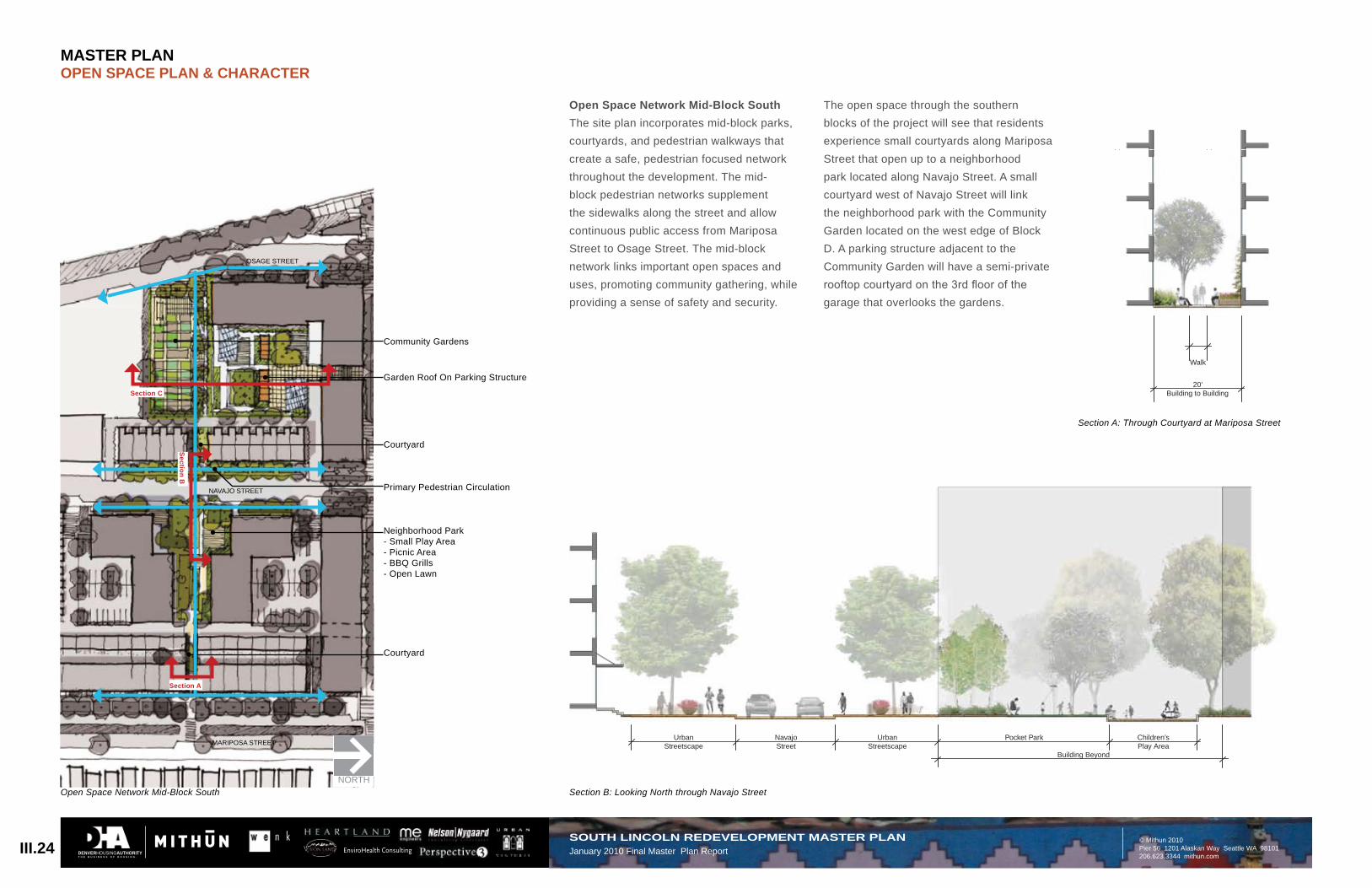
Open Space Network Mid-Block SouthThe site plan incorporates mid-block parks, courtyards, and pedestrian walkways that create a safe, pedestrian focused network throughout the development. The mid-block pedestrian networks supplement the sidewalks along the street and allow continuous public access from Mariposa Street to Osage Street. The mid-block network links important open spaces and uses, promoting community gathering, while providing a sense of safety and security.
Section A: Through Courtyard at Mariposa Street
Community Gardens
Garden Roof On Parking Structure
Courtyard
Neighborhood Park- Small Play Area- Picnic Area- BBQ Grills- Open Lawn
Courtyard
Primary Pedestrian Circulation
Open Space Network Mid-Block South Section B: Looking North through Navajo Street
MARIPOSA STREET
NAVAJO STREET
OSAGE STREET
Section C
Section A
Section B
NORTH
The open space through the southern blocks of the project will see that residents experience small courtyards along Mariposa Street that open up to a neighborhood park located along Navajo Street. A small courtyard west of Navajo Street will link the neighborhood park with the Community Garden located on the west edge of Block D. A parking structure adjacent to the Community Garden will have a semi-private rooftop courtyard on the 3rd floor of the garage that overlooks the gardens.
MASTER PLANOPEN SPACE PLAN & CHARACTER
DENVERHOUSINGAUTHORITYT H E B U S I N E S S O F H O U S I N G .
20’ Alley
Parking Structure withRoof Gardens Above
Community Garden Walk
III.25SOUTH LINCOLN REDEVELOPMENT MASTER PLANJanuary 2010 Final Master Plan Report
Neighborhood (Block) Park- Park Lawn- Large Trees- Seating Areas
Semi-Private Courtyards
Alley Access
Primary Pedestrian Circulation
MARIPOSA STREET
NAVAJO STREET
OSAGE STREET
NORTH
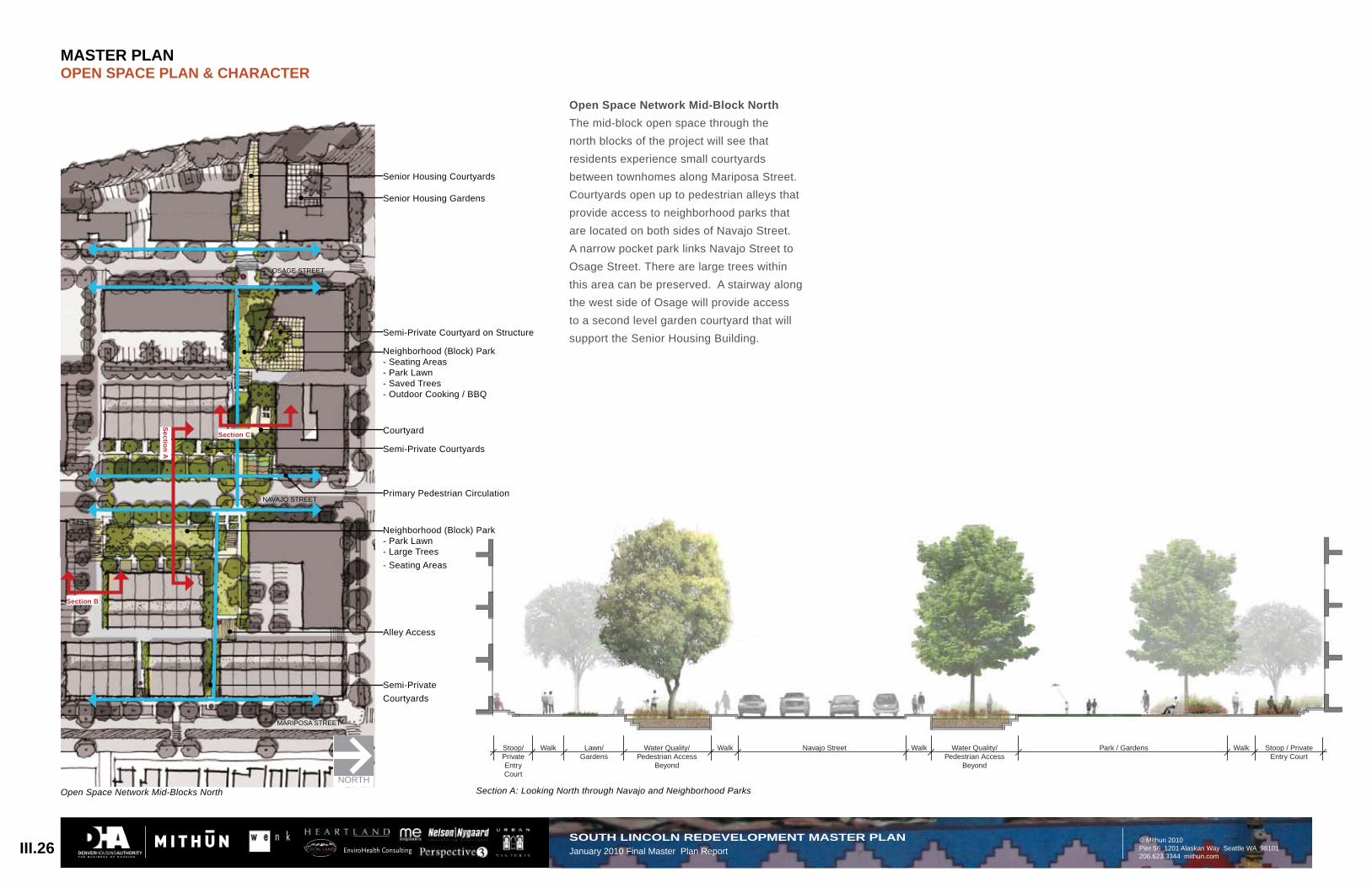
Open Space Network Mid-Block NorthThe mid-block open space through the north blocks of the project will see that residents experience small courtyards between townhomes along Mariposa Street. Courtyards open up to pedestrian alleys that provide access to neighborhood parks that are located on both sides of Navajo Street. A narrow pocket park links Navajo Street to Osage Street. There are large trees within this area can be preserved. A stairway along the west side of Osage will provide access to a second level garden courtyard that will support the Senior Housing Building.
Section C
Section B
Section A
Section A: Looking North through Navajo and Neighborhood Parks
MASTER PLANOPEN SPACE PLAN & CHARACTER
DENVERHOUSINGAUTHORITYT H E B U S I N E S S O F H O U S I N G .
16’ Paved Drive Lane
30’Alley
PlantingBuffer
Surface and Garage ParkingPlantingBuffer
PlantingBuffer
Walk Gardens/Play Area
Flexible Park Space
Picnic Pavillion
III.27SOUTH LINCOLN REDEVELOPMENT MASTER PLANJanuary 2010 Final Master Plan Report
Section B: Looking West through Parking and Alley Section C: Looking West through Courtyard
MASTER PLANOPEN SPACE PLAN & CHARACTER
DENVERHOUSINGAUTHORITYT H E B U S I N E S S O F H O U S I N G .
EnviroHealth Consulting
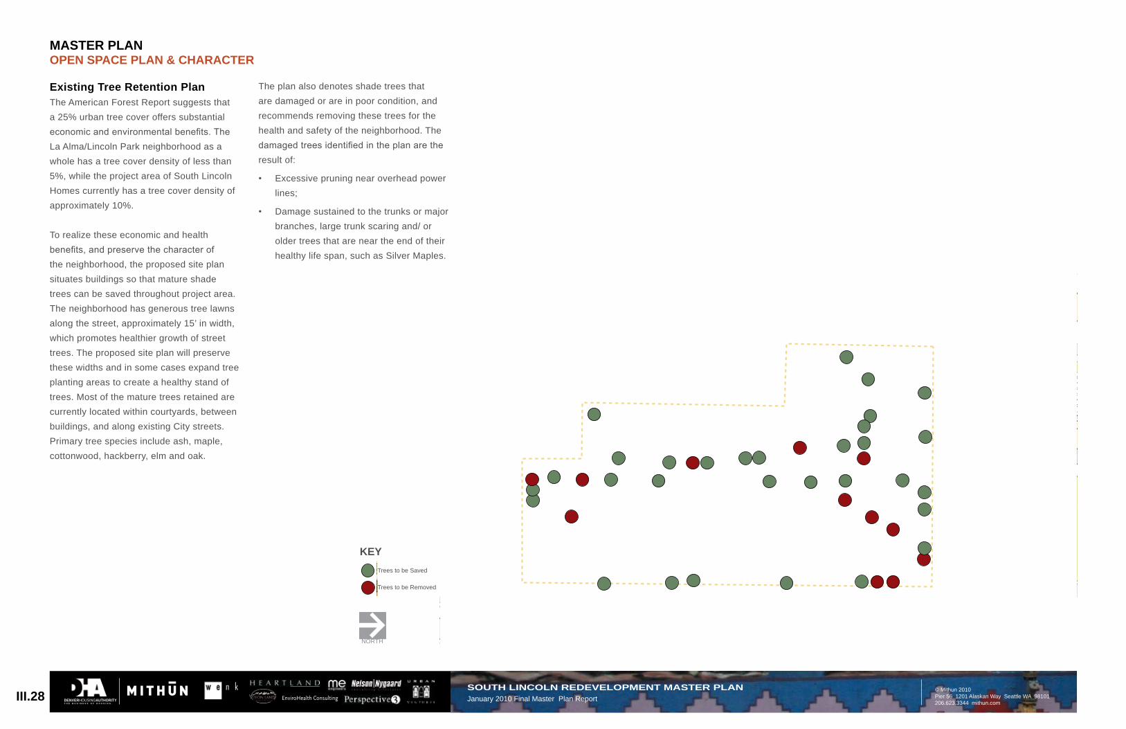
KEYTrees to be Saved
Trees to be Removed
Existing Tree Retention PlanThe American Forest Report suggests that a 25% urban tree cover offers substantial economic and environmental benefits. The La Alma/Lincoln Park neighborhood as a whole has a tree cover density of less than 5%, while the project area of South Lincoln Homes currently has a tree cover density of approximately 10%.
To realize these economic and health benefits, and preserve the character of the neighborhood, the proposed site plan situates buildings so that mature shade trees can be saved throughout project area. The neighborhood has generous tree lawns along the street, approximately 15’ in width, which promotes healthier growth of street trees. The proposed site plan will preserve these widths and in some cases expand tree planting areas to create a healthy stand of trees. Most of the mature trees retained are currently located within courtyards, between buildings, and along existing City streets. Primary tree species include ash, maple, cottonwood, hackberry, elm and oak.
The plan also denotes shade trees that are damaged or are in poor condition, and recommends removing these trees for the health and safety of the neighborhood. The damaged trees identified in the plan are the result of:
Excessive pruning near overhead power • lines;
Damage sustained to the trunks or major • branches, large trunk scaring and/ or older trees that are near the end of their healthy life span, such as Silver Maples.
KEYTrees to be Saved
Trees to be Removed
NORTH
III.28SOUTH LINCOLN REDEVELOPMENT MASTER PLANJanuary 2010 Final Master Plan Report