MASTER THESIS UNIVERSITY OF TWENTE MASTER OF ENVIRONMENTAL AND ENERGY MANAGEMENT ACADEMIC YEAR 2015/2016 The importance of Integrated Coastal Zone Management in coastal cities: The case study of Cancun, Mexico. 12 September 2016 Carlos Basurto Cisneros Supervisors: Dr. Kris Lulofs Dr. Vera Vikolainen
Transcript
MASTER THESIS
UNIVERSITY OF TWENTE
MASTER OF ENVIRONMENTAL AND ENERGY MANAGEMENT
ACADEMIC YEAR 2015/2016
The importance of Integrated Coastal Zone Management in coastal cities: The case study of Cancun, Mexico.
12 September 2016
Carlos Basurto Cisneros
Supervisors:
Dr. Kris Lulofs Dr. Vera Vikolainen
2
ABSTRACT
Urban development can come with negative impacts, even if it aims at improving people´s quality of life. These impacts are not thought of in a beginning, because first the tendency is to focus upon the economic benefits. Even though if these mentioned impacts are not seen in the first year, sooner or later, they become apparent, affecting the people that now reside in the new urban areas. This is what happened in the coastal zone of Cancun. In the first period after it was developed it represented a luxurious and exotic destination, nowadays it faces a severe coastal zone erosion problem. This problem is especially visible with regard to beach-erosion. The increase of tourism has gradually led to the building of additional new hotels along the coast of Cancun mainly in the coastal island where all the hotels are found. These hotels have been built in places were beach dunes or mangroves used to be, leaving them vulnerable to coastal erosion. In addition, this area is extremely vulnerable to hurricanes. Gilbert and Wilma, two of the most devastating hurricanes in this area, uncovered the vulnerability of the coast to extreme whether events, and by this, the absence of effective coastal management became obvious. Some other factors such as wave movement also increase the vulnerability that these coasts have towards beach erosion. Mexico issued some laws to manage the coastal resources while aiming as well at economic revenues as sustainable use of these resources. However, these laws contain ambiguous definitions of what the problem is, allowing the responsible governmental enforcers, to apply the laws in a way that suits their interests better or best. Even if the balance between economic revenues and integrity of natural systems becomes unbalanced. The fact that Mexico is a federal country also creates problems while applying and implementing coastal management laws. This is caused because political affiliation conflicts commonly arise in the country, at national, state and municipal level even though if the rest of the involved stakeholders may reach agreements to solve a coastal problem. ICZM is in this perspective an interesting concept whose main goal is to exploit in a sustainable way the resources found in the coast. It requires certain guidelines to be followed for its proper implementation. Mexican laws and policies can be adjusted in order to follow these guidelines and hence, improve the coastal erosion problem that the country faces. A total of 13 national laws and 4 state and municipal policies were analysed for this project before a conclusion was reached, however, more laws involving the coast should be analysed in order to obtain a more complete assessment on what the problem is now regarding this laws, and how it can be properly managed.
3
TABLE OF CONTENTS ABSTRACT .................................................................................................................................................... 2
LIST OF ACRONYMS .................................................................................................................................. 5
LIST OF IMAGES ................................................................................................................................... 7
LIST OF TABLES ......................................................................................................................................... 7
2.3 THE MEXICAN STATE OF QUINTANA ROO, TOURISM AND ITS NEGATIVE IMPACTS ................................................................................................................................................ 17
2.3.1 Self destruct theory of tourism 20
2.3.2 Cancun 21
CHAPTER 3. RESEARCH DESIGN ...................................................................................................... 23
3.1 RESEARCH FRAMEWORK ..................................................................................................... 23
3.2 RESEARCH QUESTION ............................................................................................................ 25
ANP Areas Naturales Protegidas Natural Protected Areas CONAGUA Comisión Nacional del Agua National Commission of Water ECE Estuarine and Coastal Ecosystem FONATUR Fondo Nacional para el Turismo National Fund for Tourism GAT Governance Assessment Tool GDP Gross Domestic Product ICZM Integrated Coastal Zone Management LGEEPA Ley General de Equilibrio Ecológico y Protección Ambiental
General Law of the Ecological Balance and Environmental Protection
MACR Mesoamerican Coral Reef NGO Non Governmental Organization OET Ordenamiento Ecológico Territorial Ecological Zoning Plan SEDESOL Secretaría para el Desarrollo Social Secretary for Social Development SEMARNAP Secretaría del Medio Ambiente y Recursos Naturales Secretary of Environment and Natural Resources SECTUR Secretaría de Turismo Secretary of Tourism ZOFEMAT Zona Federal Marítima Territorial Maritime Territorial Federal Zone
7
LIST OF IMAGES
Page Figure 1. SCUBA diving activities at coral reefs 12 Figure 2. Wave energy reduction as a service of coastal protection provided by coral reefs 12 11 Figure 3. Ecosystem services provided by mangroves 13 Figure 4. Simple hierarchy of direction-setting statements used for coastal planning and management 15 14 Figure 5. Location of Quintana Roo in Mexico 18 Figure 6. Total Tourism in Quintana Roo 19 Figure 7. Distribution of mangrove areas (green areas) in the Quintana Roo coast 19 19 Figure 8. Cancun Hotel Zone 21 Figure 9. Cancun urban contrasts 22 Figure 10. Erosion on Cancun beaches 22 Figure 11. A schematic presentation of research framework 24 Figure 12. Beach profile 30 Figure 13. Location of Cancun-Nizuc Coastal Barrier 35 Figure 14. Trajectories and forces of different hurricanes: Gilbert, Allen, Mitch and Roxanne and Trajectories and paths of the most recent hurricanes in the area: Ivan and Wilma 36 Figure 15. Punta Cancun in 1967 before the resort development and in 2005 39 Figure 16. Map of the four regions of Cancun that showed different morph dynamic responses to hurricane Wilma’s Effects 40 Figure 17. Population of Cancun from 1970 to 2010. 41 Figure 18. Beach erosion seen in one of Cancun’s beaches 42 Figure 19. Ideal structure of an ICZM programme 46
LIST OF TABLES
Table 1. International Tourists per Country in 2013 17 Table 2. Sources of the Research Perspective 24 Table 3. Data required for the Research and Accessing Method 26 Table 4. Main Evaluative Questions of Governance Assessment Tool 27 Table 5. Data and Method of Data Analysis 28 Table 6. Strongest hurricanes that have hit the Mexican coasts since 1970 40
CHAPTER 1. INTRODUCTION
1.1 BACKGROUND
Mexico has an approximate surface of 2 million km2 making it the 14th biggest country in the world. It has a population of 118 million inhabitants making the 10th most populated country in the world. Is the 14th economy and has a yearly GDP per capita of 10,123 US Dollars. (SECTUR, 2016).
The strategic position of Mexico and the wide range of natural and cultural
resources it has make it a really attractive country for national and international tourists. It is the second most visited country in America after the US and it is one of the 15 most visited countries in the world. The main amount of international visitors that Mexico has comes from the US. 36.5% of American tourists that go abroad on holidays choose Mexico as its main destination. (PWC Mexico, 2014). Tourism is of big importance for the Mexican economy. It represents 8.7% of the GDP. Regarding employment it represents 5.9% of the country´s total percentage on this matter. By 2013, the average amount of money tourists spend in Mexico is about 817.7 US Dollars per capita. In addition, about 3 million of inhabitants work in the Mexican tourism sector and 10 million depend directly on the income that is generated by tourism. (PWC Mexico, 2014). This is about 10% of the entire Mexican population. Due to this, the government has established aggressive campaigns to attract tourism at a national and international scale. Mexico’s strategic geographic location surrounded by the Pacific Ocean, the Gulf of California, the Gulf of Mexico and the Caribbean Sea provides Mexico with over 450 beaches. Most of them are really attractive to tourists for various reasons: tropical weather, great nightlife and innumerable cultural and natural attractions. (Visit Mexico , 2016). This has caused the increase on tourism demand to these destinations. In order to cope with the demand, tourism industry needs to develop strategies to be able to receive as much tourists as possible. Unfortunately, plans to expand the offer are not well developed. As a consequence, the natural areas surrounding the beaches end up being affected.
Quintana Roo, the state where Cancun is situated, is the most visited Mexican state by international and national tourists. It provides 38.9% of all the income generated in Mexico by tourism. Cancun’s airport has become the 2nd most important in Mexico, receiving yearly about 8 million passengers. (SECTUR, 2013).
In 2015, 15.7 million tourists arrived to the Mexican Caribbean; 700,000 more than in 2014. According to the SEDETUR (Secretary for the Development of Tourism), within the state there are about 905 hotels and 86,321 rooms. (SECTUR, 2013).
9
Despite all the economic benefits that tourism brings to the state (about 75% of the state’s GDP), there is an uneasy relationship between the jobs generated and the income that this activity brings, and the negative consequences it brings with it. The lack of an environmental strategy to manage coastal zones to properly manage the urban growth of the region has caused a big impact in the Quintana Roo nature areas. These nature areas are crucial for tourism as well as eco-tourism is one of the main attractions of the region. (Bezaury-Creel , 2005).
Currently in the state there are about 27 protected areas that comprise about 1,642,232 ha (about 20% of the state’s surface). Mangrove areas are one of the most common nature areas in the state. The state has about 129,921 ha of mangrove; Mangroves cover 88.2% of the Quintana Roo´s coast (CONABIO, 2009). They are crucial for wildlife and, storm protection and prevention of coastal erosion of the region. However, due to urban development purposes up to 55% of the state’s mangrove surface has been lost in the northern part of Quintana Roo (from 3,429 ha to 1,569 ha) in the past 40 years. (Aguila Arreola, 2016). One of the main attractions for tourists that go to this area is therefore facing a big problem due to lack of proper coastal management programmes to prevent coastal erosion. Mexican beaches in the Caribbean are eroding at a really fast pace. Authorities are facing a challenge to preserve the conditions of these beaches, losing them will cause a big impact on the country´s and state’s GDP, and on the people who depend on tourism activities in this area.
1.2 PROBLEM STATEMENT
Coastal erosion is a problem caused by natural processes. However, irresponsible man-made actions can aggravate this problem. The construction of hotels where coastal dunes existed as well as the removal of the vegetation found on the beaches is two important factors that can accelerate coastal erosion. Cancun is located in a geographical region that is extremely vulnerable to hurricanes. Two of them (Gilbert in 1998 and Wilma in 2005) exposed the lack of coastal planning in this city. The decision to build touristic resorts on a beach dune area located in a narrow peninsula, and these powerful storms that hit the region, aggravated the coastal erosion problem. A considerable amount of sand was lost, as a consequence, the length of Cancun´s beaches reduced; rock layers along these beaches also were exposed. (Guido Aldana, Ramírez Camperos, Godínez Orta, Cruz León, & Juárez León,
2009). Several beach restoration projects have been carried out, mainly projects where sand is taken from the bottom of the ocean and then deposited on the coast. These projects have not been completely effective. New storms and new constructions of resorts or condos on the beaches have caused their constant erosion. In addition, these sand replenishment projects have started to affect the Mesoamerican Coastal Reef or MACR (the 2nd biggest coral reef in the world).
10
Some legal structure for the proper management of the coasts exist, but factors such as: weak state institutions, really limited budget for enforcing these actions, government lack of interest on coastal issues, lack of experience or trained personnel in environmental management and the increasingly problem of corruption Mexico faces do not allow that these actions are properly enforced. (Murray, 2007).
1.3 RESEARCH OBJECTIVE
The research objective of this study is to describe in detail the coastal erosion problem that Cancun faces. What produces it, which are the impacts of it in Cancun and what actions are being taken to tackle this problem. In addition, the concept of Integrated Coastal Zone Management will be analysed. An evaluation of current Mexican laws and instruments aimed at Coastal Management will be made against ICZM guidelines. From this, a recommendation to increase Coastal Management that may help improve in reducing coastal erosion can be made to the authorities responsible to develop such plans.
11
CHAPTER 2. LITERATURE REVIEW
2.1 ESTUARINE AND COASTAL ECOSYSTEMS One of the most threatened ecosystems worldwide is Estuarine and coastal ecosystems (ECEs). They have been increasingly deteriorating due to human activities; 35% of mangroves and 30% of coral reefs have been lost or degraded. (Barbier, Hacker, Kennedy, Koch, Stier, & Silliman, 2011). The loss of biodiversity, ecosystem functions and coastal vegetation has led to biological invasions, decrease in water quality, and coastal protection from flooding and storm events. (Koch , 2009). They provide a wide variety of ecosystem services to nature and humans. The Millennium Ecosystem Assessment defines an ecosystem service as “benefits people obtain from ecosystems”. Ecosystem services provided by ECEs are a nice incentive to protect these ecosystems, however, there is a significant problem when these need to be valued. Tangible ecosystem services like raw materials, food, or those related to tourism can be easily valued because the economic benefits can easily be seen. Nevertheless, the value of some cannot be easily estimated. Ecosystem services such as coastal protection, erosion control, cycle of nutrients, purification of water and carbon sequestration directly improve human wellbeing, but since very few are not marketed, it is really difficult to put a tangible value on them and as a consequence appropriate actions to protect ECEs are not taken.
2.1.1 Coral Reefs Coral reefs are complex habitats formed in shallow coastal waters in the tropics. They can be formed near shore and extend for hundreds of kilometres in shallow offshore environments (Connell, Hughes T, & Wallace, 1997). Coral reefs provide a wide range of ecosystem services to humans, these include: raw materials, coastal protection, and maintenance of fisheries, nutrient cycling, tourism, recreation, education and research. One of the most important ecosystem services coral reefs provide is coastal protection or the buffering of shorelines from severe weather and therefore they protect coastal human populations, property and economic services. This is made by attenuating or dissipating waves and by facilitating beach and shoreline retention. In addition, these actions help the development of other coastal ecosystems such as mangroves and sea grass beds, both give additional services of coastal protection to humans. (Barbier, Hacker, Kennedy, Koch, Stier, & Silliman, 2011) Coral reefs are really valuable for tourism and recreational activities they support. Many resorts depend on the sceneries these ecosystems provide in order to attract tourists. Recreational activities such as SCUBA diving, snorkelling, island tours, and sport fishing provide a big revenue for tourism companies and for individuals
12
whose main income depend on tourism activities. It is estimated that revenues from Coral Reef tourism in Pulau Payar Marine Park in Malaysia are estimated at $390,000 US Dollars per year (Yeo, 2002). In Philippines, coral reef diving at the Bohol Marine Triangle earns revenue in the range of $10500-45540 US Dollars per year. (Samonte-Tan, Tabara, & Caballes, 2007). Despite all benefits coral reefs provide, these ecosystems are currently facing a really important menace. Pressure provided by humans by activities such as overfishing, inappropriate fishing, mining, eutrophication, pollutions, coastal development, dredging and biological invasion have put coral reefs under the threat of disappearing in several areas of the world. (Barbier, Hacker, Kennedy, Koch, Stier, & Silliman, 2011). Global warming is an important threat as well. Reefs are delicate ecosystems; they need the ocean water to be at specific conditions in order for them to keep normally providing ecosystem services. A slight increase in the ocean’s temperature can lead to coral bleaching, disease and acidification, leading to reef destruction. (Hoegh-Guldberg, 2007). Even though it is hard to estimate the total costs that coral reefs provide and an accurate possible economic impact in the case of its destruction, events such as the 1998 Indian Ocean coral bleaching event estimated economic impacts in the range between $706 million and $8.2 billion US Dollars. This figure was calculated from the economic damages from lost fisheries production, tourism and recreation, coastal protection and other ecosystems services that were provided in this area. (Wilkinson, Linden, Cesar, Hodgson, Rubens, & Strong, 1999)
Figure 1. SCUBA diving activities at coral reefs Figure 2. Wave energy reduction as a service of coastal Source: Visit Mexico protection provided by coral reefs.
Source. The Pew Charitable Trusts
2.1.2 Mangroves Mangroves are coastal forests that inhabit saline tidal areas along sheltered bays, estuaries and inlets in the tropics and subtropics throughout the world. Mangroves provide a number of highly valued ecosystem services such as: raw materials and food, coastal protection, water purification, sediment retention, erosion
13
control, maintenance of fisheries, carbon sequestration, tourism, recreation, education and research. In some cultures the use of mangrove resources is tightly related to the local culture, heritage of people and traditional knowledge. (Walters , et al., 2008). One of the most important ecosystem services that mangroves provide is to serve as natural “coastal storm barriers” to periodic wind and wave or storm surge events, such as tropical storms, typhoons, and tsunamis. (Barbier, Hacker, Kennedy, Koch, Stier, & Silliman, 2011). In addition, mangroves have the ability to retain soil in their root structures and stabilize sediment, thus, helping to reduce shoreline erosion and deterioration. (Sathirathai & Barbier, 2001). Many causes contribute to mangrove deforestation; the activities that cause the bigger impact are aquaculture expansion in coastal areas, urban development and tourism, namely land use change to build hotel resorts and parks. In Mexico, one of the countries with the biggest amount of mangroves, it is estimated that 2.5% of the mangrove area is lost per year. Although it is really hard to estimate the total economic value that these ecosystems provide, certain studies estimate that the annual benefit they provide worldwide is about $1,600 million US Dollars. (Calderón, Aburto, & Ezcurra, 2009).
Figure 3. Ecosystem services provided by mangroves.
Source. Suha Sanwar
2.1.3 Sand beaches and dunes Due to their unique position between ocean and land, coastal beaches and dunes have provided important ecosystem services such as raw materials, erosion control, water purification, maintenance of wildlife, carbon sequestration, tourism, recreation, education and research. (Carter, 1990).
14
Coastal protection is without a doubt the most important service this ecosystem provides against storms, tsunamis and sea level rise. Dunes can vary in height and width, and as a consequence in their ability to attenuate waves, depending on the presence of vegetation and sand supply from the beach. (Barbier, Hacker, Kennedy, Koch, Stier, & Silliman, 2011). Beaches and dunes provide sediment stabilization and soil retention. This controls coastal erosion and protects recreational beaches and properties located near the coast. Recreational activities such as boating, fishing, swimming, walking and sunbathing are one of the many recreational opportunities that beaches and dunes provide. In the USA 85% of total tourism comes from beach visits. (Houston , 2008). These ecosystems are of bigger importance to several countries located between the tropics. A big majority of the tourism they receive is related to beach purposes; In addition, these countries are really vulnerable to storms, therefore a good maintenance of these ecosystems is vital.
2.2 COASTAL MANAGEMENT Coastal management can broadly be defined as “the management activities at the coast, encompassing the management of everything and everyone on the coast within some form of united system or approach”. (Kay & Alder, 1999). It includes the protection, conservation, rehabilitation, management and ecologically sustainable development of the coastal zone. (Commonwealth of Australia, 1995).
Coastal management is concerned with the application of techniques that attempt to clearly focus the efforts of governments, private industry and the broader community onto coastal areas. These techniques centre on ways to bring together disparate planning and management techniques on the coast, to form holistic and flexible coastal management systems. In order to achieve this, a sense of integration needs to be adapted to all management activities; the purpose of this is to allow multisectoral development to progress with the least unintended setbacks. (Scura,
1994). Fundamental to the success to coastal management programmes is the use of
statements that clearly enunciate the purpose, directions and expected outcomes of the programme. Well-planned coastal management programmes consider such statements so that stakeholders know exactly what are the goals needed to be reached. (Kay & Alder, 1999). The choice of these statements depends on the coastal issues that are being considered, political imperatives and management scale. In order to describe clearly the philosophy behind the direction of a coastal programme, the use of a hierarchy of direction-setting statements is recommended.
15
Figure 4. Simple hierarchy of direction-setting statements used for coastal planning and
management. Source. (Kay & Alder, 1999)
At the top of the hierarchy there is a statement describing the overall direction or purpose that will guide the subsequent actions. In the next level, the statements that describe exactly what the coastal programme tries to achieve are explained. One critical issue of these statements when they are being formulated is the degree to which they are measurable, or specific as to time. At the lowest level of the hierarchy the action statements are described. These explain the overall directions that were set in the higher hierarchy levels into tangible activities, designed to meet goals, objectives, targets or outcomes that will achieve the proposed mission, vision or overall goal. It is important to mention, that there is no universal set of guiding statements. Coastal programmes around the world use different combinations of these statements according to the necessary actions needed to be taken. Kenchington and Crawford state that whatever approach is taken, an effective coastal management programme has the following characteristics: (Kenchington & Crawford, 1993)
Dynamic goal or vision of the coastal zone for the next 25 or 30 years. National objectives that guide the development of regional and local objectives
and plans A strategy, commitment and resources to meet the objectives. Legally based authority, precedence and accountability for achievement of
objectives. Monitoring and review processes
16
Political, administrative and stakeholder commitment to implement the strategy
2.2.1 Coastal management issues Coastal management initiatives are usually a response to a demand to resolve problems such as conflicting use of coastal resources, urbanization, access, pollution and environmental degradation. Problems can be related as well to lack of coordination between those who are responsible for taking decisions on the allocation of coastal resources. Some issues may be more critical in some parts of the world than others; nevertheless, understanding them is of great importance to plan an effective approach to coastal management.
2.2.1.1 Population growth This is the main driver to most coastal problems. Cities on the coast are often associated with major ports that facilitate sea transport of goods, and hence, attracting major industries. Economic growth on coastal cities provides employment and investment opportunities, acting as a magnet to people who are willing to improve their lifestyle and its economic status. Another main attraction of coasts is the need of people to go to these areas whether it’s for holidays or for retirement. Coastal lifestyle is suitable to satisfy this. In response, urban areas need to be developed or expanded to meet the necessities of new residents for housing, sanitation and transport. (Ehler, 1995).
2.2.1.2 Resource exploitation Coastal ecosystem provide a wide arrange of resources that most of the time are exploited at a really fast rate, not allowing for these resources to be renewed. Coastal renewable resources are primarily exploited in the fishery sector by commercial, subsistence and recreational fishers and the aquaculture industry. Coastal forestry focuses on the exploitation of mangrove forests. Oil and gas are exploited in many countries in coastal areas. The building of facilities to exploit these resources and the risk of blowouts or spills related to this is of major concern for coastal management activities. Coral reefs can also be exploited to obtain resources needed for building and road construction. (Kay & Alder, 1999).
2.2.1.3 Tourism and recreation Many developing countries see tourism as a potential source of income. Many do not have the proper knowledge to plan for a sustainable and well-managed industry. Most of the issues related to tourism, fall on two categories: environmental and social. Environmental issues include the impact of building tourist facilities that
17
alter the landscape, disturb natural areas and are important sources of pollution (such as sewage disposal) if they are not managed correctly. Social issues may include the displacement of indigenous communities, restricted access to coastal resources for local people and possible lifestyle changes for the community. (Kay & Alder, 1999).
2.2.1.4 Conservation reserves and protection of biodiversity Certain areas need to be preserved in order to maintain the biodiversity of flora and fauna that a certain country may have. Coastal areas are habitats for a different number of species some of which are endemic to specific regions of the world, and keeping them in undisturbed areas is crucial. The level of protection of natural coastal systems versus the level of human development and use of those systems is an on-going debate in any coastal management project. Most of the times, coastal developments require having special reserve zones that serve as buffers zones for physical processes, provide opportunities for recreation for local residents and serve as conservation areas for flora and fauna.
2.2.1.5 Coastal hazards and climate change The coast is a dynamic environment subject to natural forces that have the capacity to threaten public safety and damage property. Coastal cities are vulnerable to storms, hurricanes, cyclones and tsunamis. Since many of these events are difficult to predict, a proper management against these issues is something that is complicated. Climate change is somewhat a similar case, there are predictions on how certain factors may behave, but there is an uncertainty on how things will happen once a real problem appears. Most of actions aimed to tackle this are aimed towards reinforcement of the coasts that help reduce the impact of these issues since it seems like the most appropriate thing to do in order to protect coastal cities.
2.3 THE MEXICAN STATE OF QUINTANA ROO, TOURISM AND ITS NEGATIVE IMPACTS As mentioned before, the location of Mexico and the diversity of its beaches make it an ideal vacation spot, for national and international tourists alike, earning Mexico a spot as one of the 15th most visited countries in the world. (SECTUR, 2013)
International Tourists per Country 2013
Ranking
Country Arrivals (millions)
1 France 83.0 2 United States 67.0 3 China 57.7 4 Spain 57.7 5 Italy 46.4
18
6 Turkey 35.7 7 Germany 30.4 8 United Kingdom 29.3 9 Russia 25.7
10 Malaysia 25.0 11 Austria 24.2 12 Hong Kong (China) 23.8 13 Mexico 23.4 14 Ukraine 23.0 15 Thailand 22.4
World 1035.0 Table 1. International Tourists per Country in 2013
Source: World Tourist Barometer. Statistical Annex 2013
Due to its location in the Caribbean Sea, Quintana Roo is the Mexican state most visited by international and national tourists. It provides 1/3 of all the income generated in Mexico by tourism. Its main airport, Cancun’s airport has become the 2nd most important in Mexico, receiving yearly about 8 million passengers. (SECTUR, 2013). On 2015, 15.7 million tourists arrived to the Mexican Caribbean.
This state has about 860 km of coastline where different scenic features can be
found; from bays, inlets, mangroves, lagoons, sand dunes, beautiful white sand beaches and the Mesoamerican Caribbean Reef (MACR), the second largest coral reef in the world. This reef starts in Cancun and extends all the way to the Bay Islands in Honduras. (Sinai Padilla, 2015).
Figure 5. Location of Quintana Roo in Mexico.
Source. (Sinai Padilla, 2015)
The states tourism distribute mainly in five places: Cancun, Cozumel, Chetumal, Isla Mujeres and the Mayan Riviera. Within the state there are about 905 hotels and 86,321 rooms. (SECTUR, 2013). 43% of which belong to Cancun, the most important city in the state and one of the most famous beach destinations worldwide.
19
Figure 6. Total Tourism in Quintana Roo
Source: SEDETUR 2013
Urban growth caused by tourism has caused an impact on the state´s natural ecosystems, especially on mangrove populations. Due to its tropical climate and geographical location, mangrove forests are one of the most important ecosystems in the state. Mangrove forests that provide protection against storms, and coastal erosion cover 88.2% of the state´s coast. These forests are a crucial habitat for several endemic species of flora and fauna that inhabit in this region. (CONABIO, 2009). It is estimated that 55% of the mangrove population in the north of the state has disappeared in favour of urban development actions aimed specifically to serve tourism purposes.
Figure 7. Distribution of mangrove areas (green areas) in the Quintana Roo coast
Despite the economical success that tourism provides to the state, it has caused a big negative impact in many aspects. Zarate Lomeli lists the main sources of pollution and environmental impact in the coastal zone of Quintana Roo (Zarate Lomeli, Saavedra Vazquez, & Rojas Galaviz, 1999). They include: conversion of soils to agricultural, grazing or touristic areas, degradation of vegetation and ecosystems for the construction of infrastructure whether is urban or touristic; pollution of water, air, soil and biota due to solid, liquid and gaseous residue, fresh water consumption.
2.3.1 Self destruct theory of tourism
In the mid-eighties, several researchers came with a concept called ”self-destruct theory of tourism” This theory, states that tourism develops and declines in cyclical fashion in four phases: (Wiese, 2001) Phase I
A remote and exotic spot offers peaceful rest and relaxation for the rich, who do not want to be in contact with local residents. Phase II
Tourism promotion attracts middle-class people who come as much for the rest and relaxation, in order to taste the rich lifestyle. More tourist facilities and hotels are built in order to cope with the demand. This transforms the original objective of the place of « escape paradise » to a series of urban developments that cause consequences such as:
• Local residents become employees of hotels or work in tourism related activities. • The rich tourists go somewhere else that is more exclusive. • Due to the growth in tourist population, the interaction between tourists and local
people becomes inevitable, leading most of the times to social conflicts. • Increased tourist accommodation capacity leads prices to go down. Supply is bigger
than the demand, causing a reduction of the quality on the product that is being offered.
Phase III
In order to fill its capacity, resorts lower its prices even more, attracting persons of lower standards of social behaviour that have less economic power. A socio-environmental degradation of the area is caused due to mass tourism. Phase IV
The place becomes totally unattractive to all people due to the weight of social friction and solid waste, all tourists go away, leaving behind a significant amount of unoccupied tourism facilities, littered beaches and countryside and a local population that cannot will not be able return to its old way of life.
21
2.3.2 Cancun
Before it became the important touristic destination it is now, Cancun Island (where all main hotels are) was a barrier island; it is 17 km long and 100-400 m wide. It faced the Caribbean Sea and enclosed a shallow lagoon and it was a really important nesting site for different types of animals. There were several openings to the mangrove-lined lagoon in which there was a variety of marine life.
In the 70´s, bankers and government designed a plan to create a tax base for the newly created state of Quintana Roo (1973), it was decided to create a lavish vacation spot for wealthy people, an exclusive place where people with significant economic resources could have the ultimate beach experience. First, farmers were brought in from other states to set up the agricultural infrastructure on land to the west of the lagoon. However, poor soils resulted in these farmers becoming subsistence farmers, in the end the majority of food ended up coming up from different parts of the country.
Quarries were developed and causeways constructed in order to link the island to the mainland and thus, restricting the flow of fresh water into the lagoon. Sections of the lagoon were filled in order to build golf courses and amusement parks. Sewage treatment and waste disposal became a huge problem; eventually the exhausted quarries were used as rubbish dumps, polluting the groundwater supplies. Marinas were built on the lagoon; because of this smell and appearance change became major issues in the lagoon as well. (Wiese, 2001)
Figure 8. Cancun Hotel Zone.
Source. (Sinai Padilla, 2015).
22
Figure 9 Cancun urban contrasts22
Source. (Ambrosie 2015) Since the development of the hotel zone in Cancun, the average width of Cancun beaches have reduced significantly due to natural and anthropomorphic causes. From 70.95 metres in 1970, to an average width of 16.26 metres in 1999. Cancun has lost 60% of its beaches in the past 40 years due to erosion, an estimated 160,000 m3 of sand per year.
Figure 10. Erosion on Cancun beaches Source: golpepolitico.com
23
CHAPTER 3. RESEARCH DESIGN
3.1 RESEARCH FRAMEWORK
According to Verschuren and Doorewaard, Research Framework is a schematic presentation of the research objective. It includes step-by-step activities to achieve research objective. Research framework consists of seven steps as seen as follow: (Verschuren & Doorewaard, 2010) Step 1. Characterizing briefly the objective of the research project. This research has three main objectives. First, is to describe in detail the
coastal erosion problem that Cancun faces. What are the causes and the possible economic and social impacts this problem may cause in the city. The second objective is to analyse the concept of Integrated Coastal Zone Management (ICZM) and how it can be effectively adapted in Cancun. The third objective of this project is to analyse Mexican laws and instruments aimed at coastal management, an analysis of these will be made as well. A recommendation to the authorities responsible of coastal management of this area will be made.
Step 2. Determining the research object.
The research object in this research is the coast of Cancun, Mexico´s most popular beach destination worldwide. More specifically “The Hotel Zone” the 6 km long area limited by the Caribbean Sea to the east and the Nichupte Lagoon to the west.
Step 3. Establishing the nature of research perspective.
This research perspective of this project will be a practice-oriented research. A combination of a problem-analysing research and an evaluation research will be made. First a problem-analysing research is necessary to look for all the possible causes that create the coastal erosion at the beaches on Cancun have in order to understand the problem clearly. Once the problem is clearly defined, an evaluation of Mexican policies criteria can be made, where strong and weak points of Mexican law that is aimed at coastal management will appear.
Step 4. Determining the sources of the research perspective.
The research uses scientific literatures to develop a conceptual model. Theories to be used in this research are:
24
Key concepts Theories and documentation
Integrated Coastal Zone Management Theory on Coastal Erosion
Theory on Coastal Management Policies
Governance Assessment Tool
Preliminary Research
Table 2. Sources of the Research Perspective
Step 5: Making a schematic presentation of the research framework
The research framework is described through the following flow charts:
a) b) c) d)
Figure 11. A schematic presentation of research framework
Step 6: Formulating the research framework in the form of arguments which are elaborated
a) An analysis on theories of importance for an appropriate Coastal Management, the governance assessment tool as well as preliminary research on main problems that the area of study is facing.
b) By means of which relevant topics for effective coastal management will be identified.
c) A confrontation of the result of the analysis leads to
d) A recommendation for authorities responsible to design and implement coastal management policies.
Step 7. Checking whether the model requires any change
25
There is no indication that any change is required.
3.2 RESEARCH QUESTION
1 How do Mexican practices compare against ICZM guidelines? Are they adequate to tackle coastal erosion? What do Mexican practices lack?
1.1 Why is coastal erosion a major issue in Cancun´s beaches? 1.1.1 What are the main causes of erosion of Cancun’s beaches? 1.1.2 What are the main impacts that coastal erosion causes on
Cancun? 1.2 What is the main approach of Integrated Coastal Zone Management? 1.3 Which are the current Mexican practices that are aimed towards
Coastal Management?
3.3 DEFINING CONCEPTS For the purpose of the research, the following key concepts are defined. Coastal Management. Management activities at the coast, encompassing the management of everything and everyone on the coast within some form of united system or approach Integrated Coastal Zone Management. Is a process for the management of the coast using an integrated approach, regarding all aspects of the coastal zone, including geographical and political boundaries, in an attempt to achieve sustainability. Coastal erosion. Is the wearing away of land and the removal of beach or dune sediments by wave action, tidal currents, wave currents, drainage or high winds.
3.4 LIMITATIONS The problem that was analysed is a specific one and belongs to a specific area of study, therefore it was necessary to collect and understand all the necessary and relevant information about the area, the problem and its possible causes in order to understand the fully the scale of the problem. One of the main limitations that appeared on this research was that due to the location of the area of study, it was only possible to use existing literature and data gathered by others. The short time needed to do this research project was also a big limitation since no major interviews with any governmental agency were possible to be scheduled in large fact because they did not answer the numerous email and calls sent to them. Only one NGO called Amigos de Sian Ka’an provided answers to certain aspects of the topics talked about in this research project.
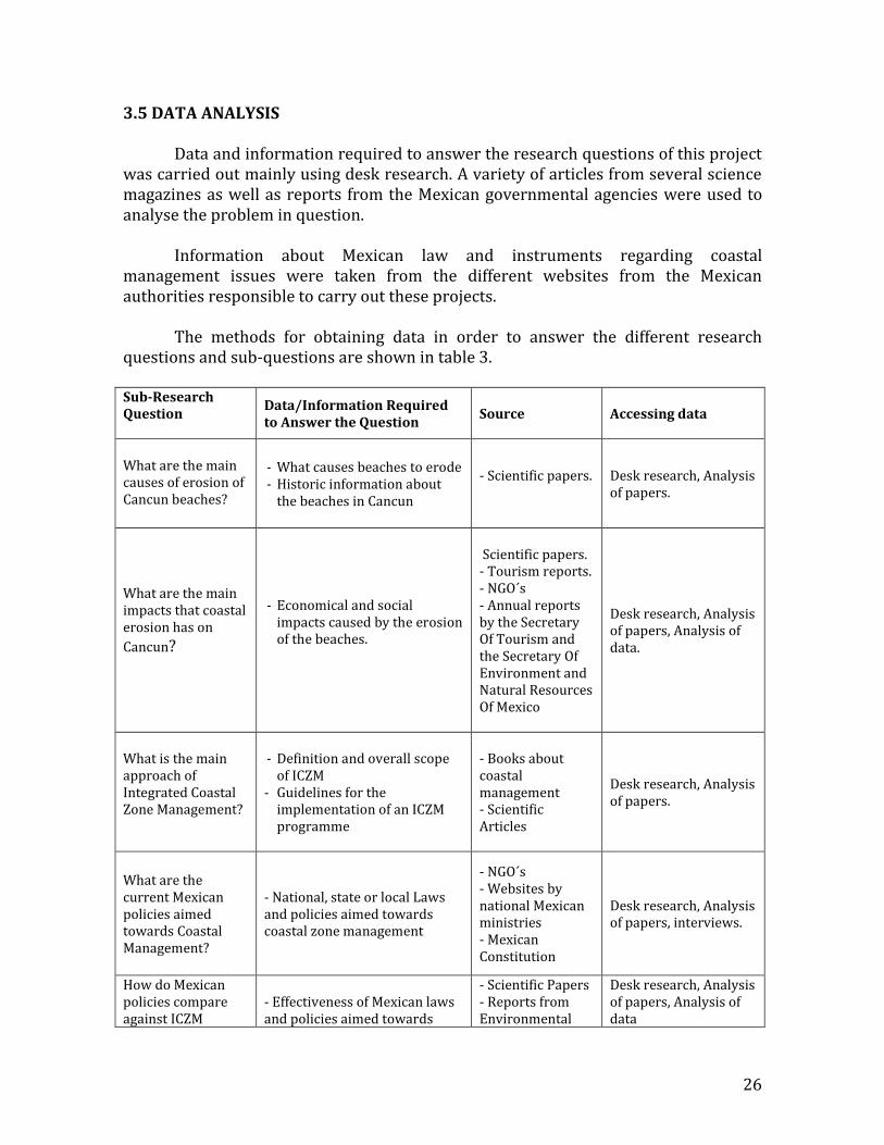
3.5 DATA ANALYSIS Data and information required to answer the research questions of this project was carried out mainly using desk research. A variety of articles from several science magazines as well as reports from the Mexican governmental agencies were used to analyse the problem in question.
Information about Mexican law and instruments regarding coastal management issues were taken from the different websites from the Mexican authorities responsible to carry out these projects.
The methods for obtaining data in order to answer the different research
questions and sub-questions are shown in table 3.
Sub-Research Question
Data/Information Required to Answer the Question
Source Accessing data
What are the main causes of erosion of Cancun beaches?
- What causes beaches to erode - Historic information about
the beaches in Cancun
- Scientific papers.
Desk research, Analysis of papers.
What are the main impacts that coastal erosion has on
Cancun?
- Economical and social impacts caused by the erosion of the beaches.
Scientific papers. - Tourism reports. - NGO´s - Annual reports by the Secretary Of Tourism and the Secretary Of Environment and Natural Resources Of Mexico
Desk research, Analysis of papers, Analysis of data.
What is the main approach of Integrated Coastal Zone Management?
- Definition and overall scope of ICZM
- Guidelines for the implementation of an ICZM programme
- Books about coastal management - Scientific Articles
Desk research, Analysis of papers.
What are the current Mexican policies aimed towards Coastal Management?
- National, state or local Laws and policies aimed towards coastal zone management
- NGO´s - Websites by national Mexican ministries - Mexican Constitution
Desk research, Analysis of papers, interviews.
How do Mexican policies compare against ICZM
- Effectiveness of Mexican laws and policies aimed towards
- Scientific Papers - Reports from Environmental
Desk research, Analysis of papers, Analysis of data
27
guidelines? What do Mexican policies lack?
coastal management agencies of other countries.
Table 3. Data required for the Research and Accessing Method
In order to enhance the robustness of the analysis of the practices, the Government Assessment Tool (GAT) will be used as well. This tool consists of a series of questions (see table 4) regarding five dimensions of governance (levels and scales, actors and networks, perception of the problem and goal ambitions, strategies and instruments, resources and organizations of implementation) and four quality criteria, (extent, coherence, flexibility, intensity) (Bressers et al. 2013) that in this case, will help to give a diagnosis of the coastal management system from a governance perspective. The GAT has shown important strengths in the analysis of water governance context in Mexico (Casiano & De Boer 2015; Casiano & Bressers 2015, Casiano et al. 2016).
28
Table 4. Main evaluative questions of governance assessment tool
Source. (Bressers et al 2015)
3.6 ANALYTICAL FRAMEWORK
3.6.1 Method of Data Analysis This research was mainly qualitative research within a sequential strategy. Collection and analysis of large amounts of data were used to carry out the project. Table 5 shows the methods of analysis used for this research project.
Table 5. Data and Method of Data Analysis
Data/Information Required to answer the question Method of Analysis
History of Cancun Beaches Qualitative: Analysing the status of Cancun beaches after the city´s development until now.
Causes of Beach Erosion Qualitative: Analysing what is causing erosion on Cancun´s beaches.
Economical and Social Impacts caused by Erosion Qualitative: Analysing which possible economical and social impacts coastal erosion brings to Cancun
ICZM (overall scope and criteria/guidelines for its implementation)
Qualitative: Analysing the concept of ICZM and how can it be applied to Cancun
National, state and local policies aimed at Coastal Management
Qualitative: Analysing the amount of Mexican policies that are aimed towards coastal management
29
3.7 RESEARCH PLANNING
3.7.1 Activity Plan
This research was carried out from the beginning of month of March 2016 until the month of August 2016.
CHAPTER 4. COASTAL EROSION
Coastal erosion is defined as “the wearing away of land and the removal of
beach or dune sediments by wave action, tidal currents, wave currents, drainage or high winds”. It is a global and major problem on coastal cities around the world. Such erosion is classified as a coastal hazard and is of main importance in local and national coastal management agendas. (Isla & Iribarne, 2009)
Rates of erosion on a certain location can vary due to a numerous amount of
factors. Beaches can be eroded as a part of a process in which sediment of a specific area is lost and transported to another area. Tsunamis, earthquakes or meteorites cause extreme cases of erosion; these are of great magnitude, however the frequency in which they can be presented is extremely low. In less extreme conditions, erosion rate can vary considerably with time; particularly, the lower limit of the shore known as “shore rise”1. Beach erosion starts mainly in the shore rise, which is affected by currents and waves. As a result from the same erosion in nearby or further area, the sediment that is removed from this part is transported and deposited somewhere else and vice versa. (Carranza-Edwards, 2010)
Figure 12. Beach profile
Source: coastalchange.ucsd.edu
Coastal erosion is caused by natural and anthropogenic causes. However, the
coastal erosion crisis is human-induced in one sense, human-made actions increase considerably the rate in which the beaches erode. If no humans lived in the coast, coastal erosion would not be the big problem that is now; this can be said because as explained above even if coastal erosion is a natural process, sediment that disappears in one area is transported to another and vice versa. Because of this transport of sediment, sand in beaches is regenerated naturally. In addition, coastal ecosystems
1 The transition between the continental shelf and the beach, marked by the increase in slope leading from the gently sloping shelf up to the beach proper. It extends from the closure depth to the breakpoint-bar.
such as mangroves, beach sand dunes and coral reefs help to catch sediment, reducing erosion rate of beaches even more.
Erosion on a particular beach can be caused by several causes at once; however, one cause often dominates more than the other. The main causes that cause beach erosion are the following:
4.1 CAUSES OF COASTAL EROSION
4.1.1 Reduction in Sediment Supply from Eroding Cliffs
A common cause for beach erosion is the reduction of supply of gravel and sand from the erosion of nearby cliffs. The particles derived from this erosion tend to be deposited in the surroundings of these cliffs where wave strength is not that strong. Along the years this process will form sandy beaches along the coastline. Cliff stabilisation in order to halt the erosion of it is usually made by building hard structures in the form of a solid wall or a boulder rampart along the base of the cliff. This is made to prevent wave attack. Inserting drains or introducing vegetation will also reduce sediment that is supplied from the cliff to the beaches by runoff, seepage and slumping. Avoiding altogether the replenishment of the beaches (Bird & Lewis 2015).
4.1.2 Reduction of Fluvial Sediment Supply to the Coast In this case, beach erosion occurs when beaches that are regularly supplied with sediment that is being carried down to the coast by the rivers, stop receiving this sediment as a result of reduced runoff. This can be caused by several factors. Diminished river flow during droughts, normally results in beach erosion. The beaches that are supplied by these rivers are restored during wet years when the fluvial sediment supply is revived. A common cause of reduction of sediment fluvial supply is the construction of dams on the upper deltas of the river in order to store it. The increase human need to get a fresh source or water or to produce electricity is the main drive to build these dams; sediments that used to arrive to the sea, are held in the water reservoir, not allowing the beaches to regenerate (Bird & Lewis 2015). .
4.1.3 Reduction of Sediment Supply from the Sea Floor During the Late Quaternary (Pleistocene and Holocene) marine transgression, sand was swept from the sea floor to the shore by wave action. Rising sea level across the continental shelf caused that waves collected sediment and carried it towards the shore. Continuing shoreward drift from shoals extended the beaches, often parallel dunes and beach ridges were formed. After some time, the sea floor acquires a
32
concave profile; wave action is no longer able to move transport sediment from the sea floor to the shore. If there is no other action that compensates sediment supply, beaches become vulnerable to wave energy and winds, and thus, beaches erode. Sediment supply from the sea floor can also be obtained in cases where shells or other particles derived from sea floor organisms found in this area become calcareous sand and gravel that drift shoreward and that are added to the beaches. Ecological changes such as the growth of sea grasses or other vegetation that impedes the transport of sediment to the coast or shell fauna destruction are factors that develop beach erosion.
4.1.4 Reduction of Sand Supply from Inland Dunes Several beaches are supplied with sand that is being blown from nearby dunes. Beaches will start to erode when the sand supply runs out, if the dune surface is sealed by built structures or if the dunes become stabilised either by natural spread of vegetation or by the planting of shrubs or grasses. Intense urbanization in coastal cities such as building roads, tall buildings and sea wall to protect them lead to a process where there is less amount of sediment exchange between the beach and the dunes; leaving the beaches vulnerable to storms and ultimately leading to the reduction of the beach width.
4.1.5 Submergence and Increased Wave Attack Deepening of near shore waters allow big waves to withdraw sand and gravel from the beach and carrying it towards the sea floor and thus, eroding the beaches. The deepening occurs mainly during storms caused mainly by cyclones or hurricanes when strong winds raise sea level along the coast. Waves whose size is bigger than normal break on the shore, eroding the beaches in which they break. Current coastal submergence caused in some cases by the extraction of groundwater on coastal zones, actual rise of sea level due to global warming, by or a combination of sea and land movement that results in the sea level standing higher than the land cause a long term deepening of the sea floor. Formation of bigger waves is more common in certain regions, as a consequence, beach erosion and re-shaping of the nearshore2 beach profile is caused by the constant impact of the waves in the shore. Sediment is carried from the beach towards the sea floor, thus, eroding the beaches. Disappearance of nearshore seagrass meadow and removal of shoals and reefs by natural causes or by dredging, increase the incidence of beach erosion caused by waves; they provide coastal defence against waves by reducing its energy. A coast
2 The zone between the most landward and seaward extent of storm driven changes in the beach profile
33
without these mechanisms of defence will become vulnerable to waves and a subsequent erosion of its beaches (Bird & Lewis 2015).
4.1.6 Interception of Longshore Drift by Breakwaters The purpose of building breakwaters is to stabilise river mouths or lagoon entrances in order to increase navigation, or to create harbours for boats. Beach sediment that comes within the beach or from other regions is transported along the shore by wind or other causes. Breakwaters retain the supply of these sediments by retaining them and thus causing beach erosion, which sometimes it may prove irreversible (El-Asmar & White, 2002). The increase on tourism, commercial activities and the increase in population on coastal cities leads to the building of hard structures in order to protect buildings built along the coast or to allow the navigation within the ports. When the construction of these structures is not well planned it can lead to severe erosion as it was in the case at Chennai, where the seaport underwent massive expansion works. The lack of planning of breakwaters led to the disappearance of nearly 400 ha of beach (Ramana Murthy, Mani , & Subramanian , 2008).
4.1.7 Beach Weathering, Including Attrition of Beach Sediment Beaches need to receive constant sediment supply as the result of weathering reduces the size of beach particles and hence the volume of the beach., the beach profile and with this larger waves are allowed to attack the beach and lead to the erosion of it. Weathering can be either chemical or physical. Chemical weathering involves the decay and removal of ferromagnesian minerals and the dissolving of carbonate beach sand grains or limestone gravels in rainwater or sea spray. Physical weathering occurs due to the beach agitation caused by wave action leading to a gradual attrition of the particles that form the sediment. Sand without the proper physical or chemical properties can become very fine, making it easier for currents of air to blow it into the backshore or towards the sea (Bird & Lewis, 2015).
4.1.8 Removal of Beach Sediment by Runoff During rainy seasons, beach erosion can result from runoff, in particular where water flows down a cliff or a steer slope carrying beach sediments towards the sea. The effects are stronger on sandy beaches than on gravel beaches where water percolates faster. Wet sandy beaches erode more rapidly than dry ones. Wet sand erodes like soft sandstone, whereas dry sand is not easily disturbed by waves. The larger the beach water table is, the faster the beach will erode. (Grant, 1984)
34
Urbanization and construction of roads increase runoff. Water runs off quickly on these surfaces not allowing water to percolate into the subsoil. Several coastal cities where urbanization has increased gradually, present severe erosion problems due to runoff, especially on places where buildings and roads have been built too close to the sea.
4.1.9 Extraction of Sand and Shingle from the Beach Sand on the beaches is extracted for building roads and buildings. The extraction of sand from the coast gives as a consequence the lowering of the beach profile; with this beaches become vulnerable to wave attacks causing erosion on the beaches in which the sand is extracted. On calcareous beaches, the extraction of shell sand and gravel used for agricultural purposes is made; beach profile is lowered and beach erosion is presented. Erosion is a common problem on seaside resorts where the beaches are intensively used. Tourists remove sand unintentionally or take shells and pebbles as souvenirs. The sand is adhered to their skin, towels, clothes and shoes, although the loss is small, it accumulates gradually, and since the people do not bring the sand back, sediment is lost and erosion is developed (Bird & Lewis, 2015).
CHAPTER 5. WHY IS COASTAL EROSION A MAJOR ISSUE IN CANCUN?
The area of study for this project is the Cancun-Nizuc coastal barrier. A 17 km
long barrier island that is located in the Northeaster part of the Yucatan peninsula on the Mexican Caribbean in the state of Quintana Roo, Mexico.
Figure 13. Location of Cancun-Nizuc Coastal Barrier. Source. Silva et al 2006
Before the development of all the area as explained in section 2.3.2 in this paper, this area was a pristine and uninhabited barrier island with a width of about 100-400 m and a north to south orientation. It enclosed the Nichupte lagoon and the Bojorquez lagoon (two shallow lagoons of 3-4 m average depth), 17 km of white sand uninterrupted beaches were found with occasionally smaller inlets that served for the purpose of maintaining the balance between the sea and the lagoon. This area is vulnerable to hurricane activity making its coasts prone to changes due to this climatic issue. A total of 46 tropical systems (storms and hurricanes) have affected Cancun since 1970. Gilbert in 1988 and Wilma 2005 have been the most destructive ones so far (Comisión Nacional del Agua, 2012). Apart from the effects of storms and hurricanes, the morphology of the coast is affected by its lack of sand sediment. The entirety of the Yucatan Peninsula is limestone, gently dipping towards the East. There are no rivers that flow on its surface in part because the limestone bedrock is fractured and filled with underground caverns. As a consequence, water drains into cracks and sinkholes and it flows under the ground and directly to the sea. (Silva , Govaere, Salles, Bautista, & Diaz, 2002). There is no sediment transport to the coast caused by river flow. Because of this and
36
other factors that will be later explained in detail, this coast can be considered as sediment-starved coast.
Figure 14. TOP: Trajectories and forces of different hurricanes: Gilbert, Allen, Mitch and Roxane
BOTTOM: Trajectories and paths of the most recent hurricanes in the area: Ivan (left) and Wilma (right). Source. CONAGUA
5.1 CAUSES OF COASTAL EROSION IN CANCUN
This paper will mainly focus on the main causes that helped the erosion problem in the region to become severe such as the development of the Cancun’s touristic project. Due to its geographical position, Cancun Island is an area prone to natural erosion, because of this and due to time constraints it is complicated to develop in detail all the factors that contribute the beaches in Cancun to erode.
Cancun’s beaches have been eroding gradually due to natural processes
throughout several years’ way before the development of the city started. As Feliz & Silva explain, the island of Cancun has a tendency to erosion due to storms and tropical hurricanes; however, the system had a capacity up to a certain way to recover itself and to maintain a certain balance (Feliz & Silva , 2007). The lack of coral reefs in front of this barrier island increases the erosion problematic in the area. The MACR begins in the southern part of the island; it does not work as a constant provider of sediment that will help to regenerate the beaches.
37
It does however, provides coastal protection against storms or hurricanes that constantly hit the coast. The rocky headlands of the island (Punta Nizuc and Punta Cancun) do not allow the constant transport of sediment between the Island and the rest of the Peninsula. The amount that enters the system is minimum compared to the one that leaves it. (Guido, Ramírez, Godínez, Cruz, & Juarez, 2009).
Different studies where wave movement pattern is studied have shown that waves normally arrive from the East and East Southwest, wave movement do not change during the year with the exception of summer, when waves arrive from the East-Northeast direction. Under those circumstances it is easy to infer that the currents will carry sediment towards the north, nevertheless there is no big evidence that sand is deposited at Punta Cancun, on the contrary, sand loss predominates in this area. Conditions of the area do not allow the sand to stay within the system (Silva,
Ruiz, Mariño, Posada, Mendoza, & Escalante, 2012); however, its topographic characteristics made the barrier island prone to natural breaching. This benefited greatly in different ways, the water in the lagoon could be renewed and also this provided relieving of the storm surge pressure by equilibrating the sea level inside and outside the lagoon reducing greatly the coastal erosion potential. (Silva, Mariño,
Enriquez, E, Escalante, & Ruiz, 2006) The development of Cancun as a touristic destination was the main factor that triggered the severe coastal erosion problem. The plans and projects that opened new frontiers to tourism transformed the original characteristics of the island. Originally, medium subperennifolia jungle, mangroves and diverse wetlands covered the island. The area of about 32680 ha as well as the numerous amount of sand dunes found along the beach gave an ecological balance to the island (Perez & Carrascal , 2000). Figure 9 of this paper provides a clear view on how the island was originally. Around 990 ha of jungle and 370 ha of mangrove were removed in order to start the first stages of the project that involved the construction of the International Airport as well as the first hotels along 13 km of the island. In order to provide an even more attractive experience for tourists where they could be as close to the beach as possible, hotels where built right next to the coast on top of beach dunes. The success of the project due to the attractiveness of the beaches caused a big amount of tourist to go to Cancun, thus, increasing the demand for available rooms. Despite being present, beach erosion was never a concern for authorities or people. That until in 1988 hurricane Gilbert, a category 5 hurricane and the most devastating of its time hit the coast. With winds up to 295 km/h (The University of
Rhode Island, 2015) the beach erosion caused by the hurricane was severe. Water storm surge rose up to 6 m and average height of waves was 12 m. Water rushed over dunes, hotels and beach ridges. About 15-20 m of beach were lost in some parts of the beach; in addition, the slope of the beach was changed. Sand retreated to the base of the hotels or to the dunes that were remaining. (Perry, McDonald, & Peterson R, 1989). Due to the severe loss of sand; calcareous beach rock was uncovered in certain areas
38
of the beach and finally the MACR was severely damaged as well, reducing the protection it provided against the attack of waves. (Dixon, 1991) During the aftermath of the recovery of Hurricane Gilbert, the Mexican Government undertook a restructure of foreign investment laws in order to attract foreign capital that could help restore Cancun as fast as possible. This opening fostered a process of land privatization and a radical reorganization of the hotel zone. FONATUR sold large parts of land to real estate investors and tourism multinational organizations. This established the “all-inclusive resort” concept to the region. (Córdoba, Baptista, & Domínguez, 2014)
Because of the factors mentioned above, the project expanded its scope in 1990; new buildings where built along the remaining extension of the beach up to what is known as Punta Nizuc. With this, around 10% of the remaining jungle was removed to continue with this ambitious project. As it was done before, hotels were built on sand dunes on the remaining area of the beach. Studies made by Carrascal and Pérez in 2000 determined that by the end of 1990 (once the maritime-nautical megaproject envisioned by FONATUR started), approximately 21.10% of the jungle surface and 7.20% of the mangroves were dismounted in order to favour the construction of hotels, golf courses, roads and urban growth in general. About 30% of the vegetation on this area was eradicated for urban and touristic purposes. As explained in section 2, one of the many ecosystem services these ecosystems provide is shoreline protection and sediment retention; this allows to the coast to maintain a certain ecological balance, allowing its beaches to recover itself gradually when they are altered by natural purposes. (Perez & Carrascal , 2000)
Once the hotels were built, the beach dunes along the coast were made rigid.
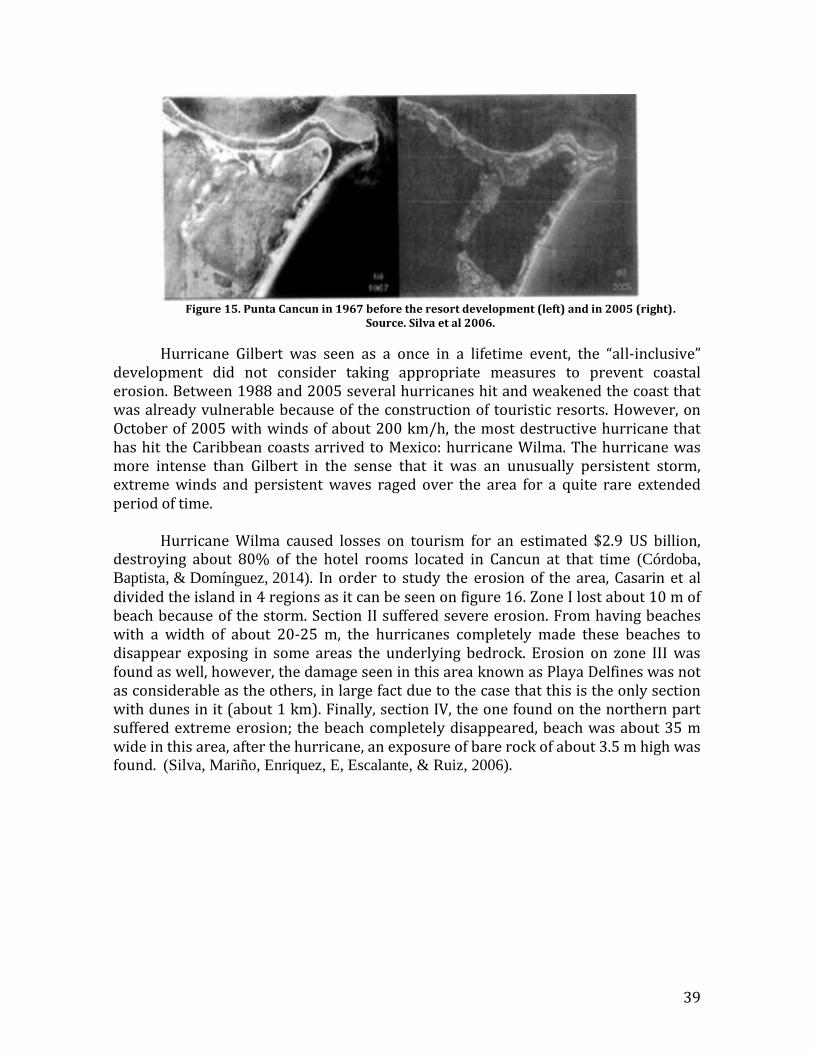
The breaching mentioned above could no longer occur; the water inside the lagoons was not renewed in a sufficient way causing severe eutrophication in them. Moreover, storm surge pressure increased in the area causing a chronic beach erosion problem. Figure 15 shows the beach width in the area that surround Punta Cancun (northern part) before the big touristic development took place when breaching was possible, and it shows the same area in 2005 once the big touristic “all-inclusive” development was in its later stages. As it can be seen, making the beach dunes rigid and thus, not allowing breaching to occur promotes beach erosion in a considerable way.
39
Figure 15. Punta Cancun in 1967 before the resort development (left) and in 2005 (right).
Source. Silva et al 2006.
Hurricane Gilbert was seen as a once in a lifetime event, the “all-inclusive” development did not consider taking appropriate measures to prevent coastal erosion. Between 1988 and 2005 several hurricanes hit and weakened the coast that was already vulnerable because of the construction of touristic resorts. However, on October of 2005 with winds of about 200 km/h, the most destructive hurricane that has hit the Caribbean coasts arrived to Mexico: hurricane Wilma. The hurricane was more intense than Gilbert in the sense that it was an unusually persistent storm, extreme winds and persistent waves raged over the area for a quite rare extended period of time.
Hurricane Wilma caused losses on tourism for an estimated $2.9 US billion,
destroying about 80% of the hotel rooms located in Cancun at that time (Córdoba,
Baptista, & Domínguez, 2014). In order to study the erosion of the area, Casarin et al divided the island in 4 regions as it can be seen on figure 16. Zone I lost about 10 m of beach because of the storm. Section II suffered severe erosion. From having beaches with a width of about 20-25 m, the hurricanes completely made these beaches to disappear exposing in some areas the underlying bedrock. Erosion on zone III was found as well, however, the damage seen in this area known as Playa Delfines was not as considerable as the others, in large fact due to the case that this is the only section with dunes in it (about 1 km). Finally, section IV, the one found on the northern part suffered extreme erosion; the beach completely disappeared, beach was about 35 m wide in this area, after the hurricane, an exposure of bare rock of about 3.5 m high was found. (Silva, Mariño, Enriquez, E, Escalante, & Ruiz, 2006).
40
Figure 16. Map of the four regions of Cancun that showed Different morph dynamic responses to hurricane Wilma’s Effects. Source. (Silva, Mariño, Enriquez, E, Escalante, & Ruiz, 2006).
Hurricanes have been an important trigger to accelerate erosion in the area.
From 1970, at least 7 hurricanes have hit the coast, weakening it and making its beaches prone to erode. Nonetheless, tourism as it was explained has been the main factor of the fast pace of erosion seen in the area. Currently Cancun has about 30 000 hotel rooms and a steady growing number of high-rise condominiums (SEDETUR,
2014). Prior to the development, beaches were able to recover themselves up to a certain point due to the presence of sand dunes and other factors such as the vegetation and the natural breaching that existed in the area. The result of human activities such as the construction of hotels on top of dunes, affect natural regeneration processes; the sand from the backshore deposits on the foreshore, causing that the erosion process to accelerate.
Hurricane Year Highest Winds Average Wave Height Allen (category 5) August 1980 305 km/h 8.6 m Gilbert (category 5) September 1988 295 km/h 12.7 m Roxanne (category 3) October 1995 185 km/h 10.5 m Isidore (category 3) September 2002 205 km/h 10.5 m Ivan (category 5) September 2004 270 km/h 7.6 m Emily (category 5) July 2005 260 km/h 12.3 m Wilma (category 5) October 2005 295 km/h 12.9 m
Table 6. Strongest hurricanes that have hit the Mexican coasts since 1970
5.2 IMPACTS OF COASTAL EROSION IN CANCUN It is no surprise that the industry that has caused the erosion problem to
aggravate is the one that will receive the biggest impacts due to coastal erosion. As of
41
2015 the Cancun and Puerto Morelos Hotel Association reported that about 4 million tourists arrived to Cancun on that year (3.892,214 to be more precise) and they left around $4,200 US million dollars in income. (SEDETUR, 2014). This is almost 50% of the tourism income that Mexico as a nation received during that year.
Cancun is a city that would have not existed if not for its beaches. Tourism is
the main source of subsistence to a big part of inhabitants in the city who work as hotel staff, merchants that sell souvenirs, owners of restaurants, bars or suppliers of food or other goods that hotels need. The big tourism development project made the city really attractive for people that lived in the surrounding areas. They saw Cancun as an opportunity for economic development (Vargas, Castillo, & Viesca, 2013). Because of the factors mentioned above, Cancun’s population has grown incredibly fast since it was established almost from nothing. In 1983 the population was about 80,000, by 2015 according to the National institute of Statistics and Geography, the population of Cancun is 743,626. (Vargas, Castillo, & Viesca, 2013).
Figure 17. Population of Cancun from 1970 to 2010.
Source: INEGI
Even though the numbers may appear that Cancun is in a healthy state due to the amount of visitors it receives and the income it gets, the attractiveness of Cancun with a significant amount of international visitors is fading. These tourists willing to go to the Caribbean are now seeking more sophisticated and under populated destination; spring breakers (once an important percentage of the international visitors and one of the main income sources of the city) have moved to more attractive destinations like Cuba. (Vargas, Castillo, & Viesca, 2013). Due to the damage that the beaches have suffered, investment has been deviated to other destinations such as Bahamas, Punta Cana and the Dominican Republic. The World Tourism Organization diagnoses that Caribbean destinations will consolidate in the following years; however, Cancun has a high chance of being left out according to them as tourists have begun to feel disappointed in which the status of Cancun beaches is. They do not find the pristine, long, white beaches that are promised by travel companies once they arrive to the destination. (Phillips & Jones, 2006).
42
Besides of the economic impact the city resents due to a decrease in tourism, Cancun receives a significant economic impact as well in the matter of beach restoration. Following the destruction that hurricane Wilma caused. The first attempt to restore Mexican beaches by pumping considerable amounts of sand from the sea floor cost approximately $19 million US dollars. In 2009, a more ambitious project to increase the width of the beaches cost about $70 million US dollars. (Geo-Mexico,
2010). There is not transparent information by the cost of the constant restoration projects that the state and national government are carrying out. But as experts of the National Polytechnic Institute state “there is no alternative but to artificially compensate for the sand that is being lost”. This means that the bill for restoring the beaches will only grow with time. (Tegel, 2013) One of the main impacts felt and one that does not attract too much attention is the social impact of this problem with the local community. As erosion progress and beaches become smaller, big hotels or owners of condominiums facing the coast act at a faster pace to privatize big portions of the remaining beaches or to block public entrances to them. People that live in the city cannot enjoy them and as Campos et al mention, “locals feel that they have been stripped and segregated from development and from the best opportunities. They believe that people that come from outside is benefited as they pay with US dollars” (Campos, 2008). It is said that Mexican people do feel like foreigners in numerous touristic destination in their country by suffering discrimination from the touristic service operators, this in large part as the majority are not able to pay hefty amounts of money like their counterparts the international visitors who pay in US dollars. People get used to this provoking emotions who vary between irritability, fatigue and depression; decreasing progressively the quality of life of the local people that is not able to enjoy what they feel its theirs. (Garcia, 2010). The only two beaches in the whole 17 km beach strip that conforms Cancun island are: Playa Delfines and Playa Langosta (Dolphin Beach and Lobster Beach). It is not a surprise that as explained before, these two beaches are the ones that presents lowest rates of erosion since no hotels are built in them. (Vargas, Castillo, & Viesca, 2013)
Figure 18. Beach erosion seen in one of Cancun’s beaches Source.Coastalcare.org
43
CHAPTER 6. INTEGRATED COASTAL ZONE MANAGEMENT
6.1 PRINCIPLES OF INTEGRATED COASTAL ZONE MANAGEMENT The information gathered for this section is based mainly on two documents
that were provided by the person interviewed of Amigos de Sian Ka’an. He mentioned that they would be able to provide enough necessary information to develop this chapter. While ICZM is a concept known worldwide that has been applied for some years in some parts of the world, there is currently not much available and there is no detailed information unless contact with experts in the matter is established. Because of this and also due to time constraints to develop this project, the information in this section will be based mainly on two documents published by Post & Lundin (1996) and another one that explains the ICZM process published by UNEP (2012). Information gathered from other sources will be properly quoted and mentioned in the reference section.
ICZM has been explained by experts of the Food and Agriculture Organization
of the UN as follows: “ICZM provides the opportunity to allow policy orientation and development of management strategies to address the issue of resource use conflicts and to control the impacts of human intervention on the environment. It provides institutional and legal framework, focuses on environmental planning and management, coordinates various concerned agencies to work together towards a common objective. Sectorial planning and management, is still [essential but should operate within the general framework of ICZM. Maintaining species habitats, natural resource base and management of development processes are part of ICZM programme”. (FAO, 2016)
This definition encompasses the three main objectives in which ICZM focuses:
strengthening sectorial management (mainly done by legislation, training, staffing), preserving and protecting the biological diversity and productivity of coastal ecosystems (done mainly by preventing pollution, habitat destruction and overexploitation) and finally promoting a sustainable use of coastal resources.
For an ICZM programme to be successful it is of great importance that the
policy and goal setting aspects be as accessible and open as possible to all the involved stakeholders and people interested in this process. Allowing detailed discussions and questions with the support of clear and understandable documentation will ultimately lead to the proper selection of goals and policies that are going to be the central objectives of the programme in question. It is relevant to add that these ICZM preparation programme of establishing goals and policies should not be rigid in the sense that unanticipated events can always occur: new coastal resources can be discovered, urgent problems may suddenly emerge, new uses of the coast may be proposed. Due to this, new goals and policies can be set by the group that oversees the
44
development of the programme as a measure to deal with such unexpected events as they occur.
Another important principle of ICZM is the need to build understanding and a
strong political alliance among all the concerned sectors on coastal communities. The appliance of strong regulatory measures such as the “polluter pays” principle, the limiting of exploitation of certain resources or the application of user fees to name a few, will require convincing justification. Public education programs are needed in order to reduce the resistance of groups that may feel affected by the appliance of these regulatory measures.
In addition, the formulation of an ICZM plan must be made on a reasonably
short period. This is crucial to take advantage of the energy and momentum generated in the early stages of the planning as stakeholders and government agencies can lose all the interest if the formulation of the plan takes to long to develop.
Coastal nations need to develop an ICZM structure that suits specifically to that
nation. It needs to fit to its institutional and governmental arrangements, to the nature of its coasts, the economic conditions and not less important, to the cultures and traditions of the country in which is applied.
Post and Lundin describe specific characteristics that make ICZM an effective
management framework (Post & Lundin, 1996):
ICZM seeks to manage the coastal zone as a unit whose future must be managed and planned as a whole; using an ecosystem approach where possible. It addresses coastal waters and shore lands together, as a unified program. Lowlands, intertidal areas, coastal shore lands, open waters and lagoons will be part of an indivisible and interactive unit.
It is an analytical process that advises governments on priorities, trade-offs, problems and solutions.
It is a dynamic and continuous process of administering the use, development
and protection of the coastal zone and the resources it contains. This is achieved through democratically agreed objectives.
It recognizes the interconnection between the coastal systems and its uses by
employing a multidisciplinary, holistic systems perspective.
It keeps a balance between protection of coastal resources and ecosystems and the development of coast-dependent economies; prioritizing the use of the coastal resources while taking in account the need of minimizing the impact to the environment as much as possible.
45
It works within established geographical boundaries established by the local governing bodies. All coastal resources are usually included within these boundaries.
It seeks the input of all the involved stakeholders as policies for an equitable
use and allocation of coastal resources will be made by the structure that is in charge of the decision-making and that oversight the whole process. This is made to avoid or solve all the possible conflicts that may appear during the process.
Within ICZM, iterative solutions are needed to solve complex issues whether
they are economic, social, legal, regulatory or environmental ones.
It raises the awareness on the government and community alike about the significance of sustainable development and the importance of environmental protection.
These characteristics make ICZM an ideal framework to tackle coastal
management problems. If planned and steered correctly, an ICZM programme can:
Minimize costly delays in the implementation of a project Minimize the damage made to marine environment and its resources. Minimize economic losses (caused by resource depletion, access
limitations, etc.) to the various users that benefit from coastal resources. Make an efficient use of the infrastructure, information and available
technology to marine development sectors. (FAO, 2016).
Ideally, an ICZM programme structured as shown on figure 19, will have significant chances to be successful.
46
Figure 19. Ideal structure of an ICZM programme
Source. UNEP
6.2 GUIDELINES FOR DEVELOPMENT OF ICZM PROGRAMMES Given to human nature, reacting to problems instead of trying to prevent them is one of the defects that are most commonly seen actually throughout the world. Typically, a major event or crisis raises awareness of a problem to government and stakeholders alike. Precipitate measures to solve the problem are often taken due to the lack of previous planning and management efforts to tackle problems when it first appear, despite these being more traceable and its solutions less expensive at an earlier stage. Even though the content of each ICZM programme cannot be the same for many different reasons (characteristics of the region are not the same, different laws and policies, different economic interests, involved stakeholders, etc.), certain guidelines are to be followed if the programme is going to be steered in the correct direction. This will ultimately lead to the development of an effective strategy that will help to address the issue for which this programme was planned in the first place.
47
6.2.1 Triggering the Need for ICZM There are different factors that may trigger the need for an ICZM programme:
Serious problems of resource depletion on coasts. Increase of pollution of the ocean and coastal environment. Severe damage or disappearance of coastal ecosystems. Conflicts of interest between all the interested stakeholders in the area. Increase economic opportunities related with new forms of development or
better use of resources in the coastal zone.
Local government officials and local stakeholders tend to be the first ones that recognize common issues on coastal areas such as coastal source depletion or environmental problems. They can be the first ones as well to prepare to solve the problem and start the ICZM process before the involvement of the national government.
6.2.2 Who Gives the Go-Ahead? Usually in all governments, a formal approval is needed in order to initiate a new programme, especially those who require allocating significant responsibilities to institutions or those who require important amounts of money to properly develop a programme. Generally in order to apply for this approval, a “decision document” is drafted in which the needs for a new programme are explained. This document must explain what it is intended to be accomplished, how the programme will be developed and by whom, and how much money and time will be required.
During this stage, there is not the intention and purpose to perform a detailed analysis of the area or to uncover the complex interrelationships between issues. Since this is a document intended only to apply for government’s approval, it is only necessary to map the range of nature and human forces, the sectorial policies that currently exist, and their interrelationships. It serves as a trigger to initiate the process providing a focus for discussion between the stakeholders. One of the most important aspects of this stage is that this document should be drafted by local and national government agencies that will be involved in the development of the process and at a later stage in the ICZM programme itself. It should serve as a tool to engage stakeholders by using non-technical language, having a good design and appropriate visualised media. Stakeholders that have an interest in this area should be participants from this process as well. A joint cooperation between everyone involved should guarantee up to a certain point that all interests from everyone would be taken into account.
48
6.2.3 Who Does That? Roles and Responsibilities in the Coastal Zone In a successful ICZM programme, important roles must exist for all the involved stakeholders. One of the main keys for success to a programme is the complete involvement of everyone and the demonstration that the ICZM programme is in the long-term interest of as many people as possible.
According to Mr. Tamayo from Amigos de Sian Ka’an, each involved stakeholder brings a key contribution to the ICZM programme during the planning and the development of it. The stakeholders that should be involved and its roles and responsibilities will be mentioned in the following paragraphs: The Coordinating Committee This coordinating committee oversees the implementation and operation of the ICZM programme, providing general management and support responsibilities. One of the main activities it does is to:
Reduce tension and rivalry between the involved stakeholders by promoting the collaboration between all of them
Monitors and evaluates the progress that has been made in the ICZM projects and programmes
Implements actions that come as a result from these evaluations. Provides support activities in the topics of: budget coordination, political
accountability, environmental impact assessments, human resources development, transnational issues, establishment of zoning schemes and implementation of management actions.
This committee can be established from different ways: from the creation of a
special coordinating commission, by allowing a national planning agency or ministries to perform these activities or by formal establishment of an interministerial council. It must be carefully chosen in large fact because they will be one of the responsible to steer the ICZM programme in the proper direction.
Ideally, it must be a multidisciplinary group formed by experts on coastal management, environmental management, resource economics, ecology and regional planning. Other experts that may not form the initial group may be borrowed from governmental agencies if needed, such as: specialists in coastal erosion, fisheries, environmental lawyers or engineers. Having experts that cover all the aspects that about to be established in the ICZM programme guarantees the majority of the times that the whole ICZM process will be overseen and steered in the most appropriate way.
49
National, State and Local Government They provide crucial support if an ICZM is going to be successful. It usually provides an important part of the funding needed for these projects to be launched. In most cases, certain individual departments of the national government provide important coastal and environmental information stored in its databases. Moreover, all or the majority of the existing management and regulatory authorities are controlled by the national government.
In countries that are federally organized, if a particular coastal zone of one state is affected, the activities mentioned before such as funding and management activities will fall on the hands of the state government. Local governments are often the ones who are closest to the problem, the ecological and economic health as well as the productivity of the coastal zones is of big concern to them. Many coastal cities depend solely on coastal resources; therefore they must have fully commitment and involvement in the ICZM process. Line Agencies and Ministries They are essential participants in the ICZM process. Specialized agencies and ministries generally possess the best data and expertise in particular fields such as control of coastal erosion, management of offshore gas and oil operations, and fisheries management among others. Research Institutions Good and reliable data and information is necessary if an ICZM programme is going to be successful. In the case where governmental agencies and ministries are not able to provide it, research institutions or universities can usually assist in this task. They are capable of collecting and analysing the data necessary that is related to environmental degradation, coastal resources, new economic development opportunities, etc. Coastal Stakeholders In this category, groups or individuals whose economic survival depend on the health and productivity of the coastal resources or who put a high value on the touristic, aesthetic and recreational value of the coast. The main drive and momentum usually comes from this group, as they may feel they are the most affected due to the destruction or depletion of the coastal resources. They must try to create a “will” on government policymakers in order to make the establishment of an ICZM programme an important part in their agendas.
50
General Public Some involved stakeholders consider general public as a sector that should not be involved in ICZM programmes. Even though, they may have a point in the sense that coastal activities may not have a direct social or economic impact on general public, they are in fact of great importance. A well-educated general public supporting the changes established in the ICZM programme can serve as a counter-balance to put pressure and serve as opposition to actions that may favour stakeholders with a bigger economic power. This pressure at times proves crucial to reversing or modifying decisions that were taking in the earlier stages of the planning.
6.2.4 Formulation of the Plan The first considerable effort on establishing an ICZM programme is the plan’s formulation. It should be a logical output that clearly explains the preceding stages of the ICZM process. To simply put it, it is an integrated set of integrated and desired outcomes (the what) along with an action plan to achieve them (the how). The Mediterranean ICZM protocol in its article 18 states that plans “shall specify the orientations of the national strategy and implement it in an appropriate territorial level, determining where appropriate, the carrying capacities and conditions for the allocation and use of the respective marine and land parts of coastal zones” (UNEP, 2008). In order to formulate an appropriate plan, certain actions are needed to be done, such as: Creation of Plan Formulation Team To the biggest possible extent, members that belong to key government agencies that have crucial roles regarding coastal resources and coastal zones shall compose the plan’s formulation team. All key agencies whether they are local or national should be represented. A governmental figure representing a higher policy level (the president’s or prime minister’s office, the national planning office, to name a few) should direct this team. This team should assess and address issues such as enforcement mechanisms, technical competence, access to funds and legal authority. Assembly of Necessary Data and Information Good and reliable information regarding the economic, social, physical, economic and governmental aspects of the coastal region where the ICZM programme will be applied is needed. Some information may already be available in existing national environmental action plans, development plans and other sources of information; this can be provided by government agencies, universities and other research institutions, and in some cases international organizations. In the cases
51
where data of importance for the ICZM programme is lacking, new initiatives to collect primary date should be made. Information from different areas is required for the formulation of the ICZM plan, it is not mandatory that this information is in hand before the analysis and assessment work begins, some information and data gaps can be filled in the following stages of the programme. Data of the following types is needed:
Coastal resource base: regarding existing coastal resources and its use, present status of the coastal resources and potential for present and future use.
Social Organization in the Coastal Zone: Regarding the existence of indigenous people and their traditions related to coastal systems, the existence of human settlements and its economic basis and social issues.
Existing Environment and Resource-Related Programmes: It involves all programmes related to environmental regulations, fisheries management, protected areas, beach/erosion management, pollution control and other existing programmes that may be applied in the coast that is being studied.
Institutional, Legal, and Financial Capacity: All the relevant institutions that are involved in the area (national, regional, local), as well as existing capacity efforts including the ones that are being funded by external sources.
Determination of the Management Area: The coastal zone tat will be managed must be determined. This chosen area should include all the resources of interest and the activities that may cause an impact on the resources of the coastal area.
Role of the Nongovernmental Sector: Governments with limited power in regions where private sector has bigger influence and resources than them, can create incentives to promote long term planning and sustainability in the area. This assure that the private sector will have long term benefits and it will allow the government to use its resources in the enforcement of the rules and the new management regimes that will be formulated.
Assessment of New Economic Development Possibilities in the Coastal Zone: By doing appropriate market studies in the region, economic development possibilities can be assessed. The impacts and risks of the proposed development projects on the coastal and marine environments need to be studied as well.
6.2.5 Programme Implementation There are many cases where some parts of the ICZM programme start functioning earlier than others. Usually in order to obtain the necessary executive and legislative approvals may take a considerable amount of time. With the implementation of such programmes major legislative initiatives are not always required. There are certain countries in which an administrative rule or decree is enough for all the parts of the programme to be implemented. Data base development
52
and inventory can be done in advance in order to gain more time since this activity does not require a legislation to be done. Once the formal governmental approvals and the required legislations are in place, the ICZM is formally established and the implementation begins. Certain countries opt for a creation of a coastal agency into which all activities related to the ocean and the coast are placed. The possibilities to enhance the ICZM implementation can be done if:
Improvements with high visibility can be fulfilled at earlier stages of the program.
If the overall goals of the programme and sub goals found on different elements of the programme are clearly articulated and they are expressed in measurable terms.
The policies that the programme will follow are clear and not spelled out in an ambiguous form.
All the institutions mentioned in the programme have clear and specific roles and will be able to hold accountable.
There are enough financial and human resources for the correct implementation of the programme.
The general public has been clearly informed on what the ICZM programme tries to achieve in order to support the overall effort.
There are adequate resources to perform activities such as monitoring, evaluation, and enforcement.
6.2.6 Monitoring, Evaluation and Enforcement Results of an ICZM must be continually monitored and evaluated in order to improve in aspects in which this programme may not be properly working as expected. Therefore, it is of big relevance that goals of the programme are clear and be able to be measured as much as possible; if this is not made, the assessment of these goals will be made in a deficient way, as a result, the possibility to measure if the programme is working correctly will not be possible. A monitoring procedure should include activities such as:
Identification of expected performance Measurement of the actual performance of the programme Establishment of performance variances (shortcomings or excesses) A procedure to communicate variances that exceed pre-established limits to
the management authorities.
Enforcement of rules and regulations is one of the most difficulty tasks that governments have. The main objective is to have general rules that the society accepts and therefore are able to be enforced. A well-informed society and most importantly a
53
good credibility of government programmes is crucial for this to be done. Nonetheless, if parties are benefiting economically for breaking the rules that were established, strong and objective enforcement will be required from the government. The success of an ICZM programme lies when everyone involved do their own part within the limits of the rules and regulations that were established.
In the end the success or the failure of an ICZM programme will depend on its
ability to catalyse change. That is the most important thing about it, not the specific process, the strategy or the plan, but whether or not the programme results in positive actions.
54
CHAPTER 7. MEXICAN LAWS AND INSTRUMENTS AIMED AT COASTAL
MANAGEMENT
To acquire information needed for to answer this chapter, different national governmental organizations such as SEMARNAT, SECTUR, FONATUR, CONAGUA and state and local ones that are in charge for management of the coast were contacted. No answer was offered for most of them. SEMARNAT referred to information found on their website. Moreover, websites from the state ministries of the coasts from the state of Quintana Roo and the city of Cancun were in constant maintenance. Documents published in the Official Federal Diary regarding coast management, Ecological and Marine Planning Programmes from the State of Quintana Roo and the articles cited in the Mexican Constitution were the main sources of information. The work of (Segovia et al 2007) was also used for this section. In Mexico, the main reference for the maritime-coastal legislations is found within the Mexican Constitution; here, the concepts of maritime and terrestrial national property are defined and the sovereignty and jurisdiction of them are established as well. It is important to mention in this chapter that the legislation regarding coasts in Mexico is done in a sectorial way; tin order to explain it better, the land part is managed by laws such as the General Law of National Goods, the General Law of Ecological Balance and Environmental Protection to name a few, The maritime part is managed by laws such as the Sea Law, the Fishery Law, etc. There are several laws and instruments used by Mexican government actors that relate to the use, conservation and protection of coastal zones located on Mexican territory. Due to time constraints, an analysis of some of the most significant laws and instruments will be made in the following paragraphs. The main criteria for selecting the following laws and instruments for its consequent analysis, was their considerable focus on coastal management matters. The ones that were chosen were selected mainly because they were the ones that were considered more crucial to tackle the coastal erosion problem that affects Cancun’s beaches. Detailed information of all laws is deemed impossible because of the short period of time that is given to do this research. In order to obtain a general scope of Mexican legislation that is aimed at coastal management, a general overview made by Segovia et al for the SEMARNAT (2007) was used as a basis for the selection of laws. The current versions of this legislation were the one used for the analysis.
7.1 POLITICAL CONSTITUTION OF THE UNITED MEXICAN STATES Article 4:
The main idea of this article is that every person has a right to an appropriate environment for its health and development. An environment that allows the development and well-being of people depends of the existence, preservation,
55
restoration, and rational and sustainable use of the natural resources that the country has. Article 25: In this article it is stated that Mexican state is obligated to include the environmental variable to the national planning strategy. This article establishes that economic development should not be made at the expense of the deterioration of the natural resources that the country has, on the contrary, there must be a balance between the productive activities and its rational use. Article 27: Natural resources subject to appropriation (susceptible to be private property) are subject to the regulation dictated by public interest. A concession is required for the exploitation and use of the resources, establishing that concessions will be given according to terms and conditions that Mexican laws establish. This article mentions as well the capacity of the government to dictate measures to preserve and restore the ecological balance. Article 73:
This article mentions that the use and exploitation of natural resources is regulated and limited by what is established in the respective federal laws approved by the legislators of the Mexican congress. Article 115: This is an important article regarding local management as it establishes the rules for the municipal organization, its faculties and the rules in which they will be subject. Municipalities can:
Formulate, approve and administrate the zoning and urban development municipal plans.
Give licenses and permits for building construction. Participate in the creation and administration of ecological reserve zones and
in the application and elaboration of programmes regarding this matter.
7.2 MEXICAN NATIONAL LAWS AND REGULATIONS
7.2.1 General Law of the Ecological Balance and Environmental Protection (LGEEPA) This law is the responsible to regulate the preservation of restoration of the ecological balance, as well as the biodiversity and environment protection in the national territory and in the zones in which the country extorts its jurisdiction, coastal and marine zones included.
56
The LGEEPA distribute environmental responsibilities between the federation, states and municipalities. Within them, it is responsibility of the federation to formulate and conduct environmental policy at a national scale. Likewise, it will apply instruments of environmental policy and regulate the actions of preservation and restoration of ecological balance and environmental protection that are made en zones where there is federal jurisdiction. Regulation of the sustainable use, protection and preservation of national waters, biodiversity, fauna and other resources are part of this law as well. The law gives a concept of biodiversity that delimits the ambit in which the SEMARNAT will work. It establishes the principles for which the federation has competences in matter of sea and coast environmental policy as well as the ability to regulate the exploitation of the marine biodiversity in order to regulate its sustainable use. The LGEEPA establishes instruments of environmental policy that regulate ecological order, the evaluation of the environmental impact, economical instruments, environmental regulation of human settlements, environmental official Mexican norms, auto regulation and environmental audits.
7.2.2 General Law of National Assets This law contains dispositions that refer to the marine environment. Establishes within the classification of national heritage the assets of public domain of the Federation, the assets of common use such as the territorial sea (12 nautical miles), the interior marine waters, the maritime beaches (portions of land covered and uncovered by the tide) and the maritime-terrestrial federal zone or ZOFEMAT3 (20 m). SEMARNAT is responsible to delimitate the ZOFEMAT; promote the sustainable use of this zone and the land reclaimed from the sea. SEMARNAT in coordination with other ministries that have jurisdiction in the zone shall establish the applicable norms and policies, considering the urban development plans and programmes as well as the ecological order.
7.2.3 General Law for Sustainable Forest Development and its regulation This law protects coastal forest vegetation. Its exploitation is subject to an authorization by the competent ministry. When the exploitation of these resources is made in an area bigger than 20 ha, the presentation of an EIA will be required, this will be integrated to the intermediate or advanced forest management programme depending on the hectares to be exploited.
3 The Maritime-Terrestrial Federal Zone is the 20 meters wide strip of firm, walk able and land adjacent to the beach
57
Applicable to coastal issues, this law mentions what is related to the change of use of forest soil. Even though the Mexican Norm NOM-059-ECOL-2001 protects the four types of mangrove found in the country (as mentioned before Cancun is in a region where mangrove exists) because they are consider in danger of disappearing, this norm does not regulate the total or partial removal of the vegetation in the area in order to use the land for other purposes; this law regulates this issue under the following terms: The change of use on the forest soil will require authorization by the SEMARNAT, which may authorize it based in the technical opinion of the State Forest Council as long as it is proved that biodiversity will not be compromised, erosion of soil will not be caused, the water quality will not be deteriorated and that the proposed use of the soil will be more productive on the long term. These studies will be made at the same time and not in an isolated way. The authorizations that will be emitted must meet what it is established in the corresponding ecological planning programmes, the official Mexican norms and the applicable legal dispositions.
7.2.4 General Law for Wildlife This law empower SEMARNAP to install refugee areas to protect aquatic species found in waters of national jurisdiction, ZOFEMAT and floodplains with the purpose to conserve, using appropriate management measures, the species found in the designated zone. In addition, the law regulates the conservation of wildlife outside their natural habitat, the liberation of animals to the natural habitat, exploitation of them with survival purposes and sport hunting The exploitation of forest resources and species whose total living habitat is water are excluded from this law, with the exception that these species are threatened or in danger of extinction.
7.2.5 General Law of Human Settlements Its main objective is the panning and regulation of the territorial order of human settlements and the urban development of the population centres, through plans and programmes of urban development at federal, state and municipal level; empowering local authorities to approve, execute, control and evaluate these plans. Such plans and programmes must abide to the general criteria of ecological regulation of human settlements established by the LGEEPA and tin the official Mexican norms related to ecological topics.
58
7.2.6 Law for Sustainable Rural Development It focuses in promoting the integral improvement of the well-being and economic activities outside the nucleus considered as urban, assuring the permanent conservation of natural resources, biodiversity, and environmental services of that territory. National government must foment the investment in infrastructure to make this possible.
7.2.7 Federal Law of Tourism The Secretary of Tourism together with the Secretary of Social Development and in coordination with federal and municipal governments are in charge to formulate the corresponding declaratory of zones of priority touristic development, according to the local urban development plans and the declaratory of use of touristic land; in order to create or expand the priority touristic development centres, as well as the creation of centres dedicated for social tourism. The Secretary can designate priority touristic development zones to those areas that due to its natural, historic or cultural characteristics can constitute a touristic attraction.
7.2.8 Regulations for Nautical Tourism Establish the obligation to operators, owners and users of small crafts used for leisure or sports activities to adopt the appropriate measures to avoid intentionally or unintentionally the contamination of Mexican waters. In order to provide tourism services to third parties, owners of these crafts must have the corresponding permit and the authorization of the competent authority in order to be able to use the beach zone and the routes that have as a destination parks, protected marine areas or ecological reserves
7.2.9 Federal Penal Code In the matter of coastal areas, the code establishes the following: A penalty of one to nine years of prison and the equivalent of 300 to 3000 days of penalty fee will be imposed to those who illicitly:
I. Capture, damage or kill any specimen of turtle or aquatic mammal or recollects in any way its products or sub products.
II. Capture, transport or damage specimens of aquatic species designated as threatened.
III. Perform hunting, fishing or capture activities of any fauna specimen in a restricted area.
59
IV. Introduce or extract illicitly species of wild flora or fauna that are considered as endemic, threatened, in danger of extinction or that subject to any special protection regulated by any treaty in which Mexico is part of.
A penalty of two to ten years of prison and the equivalent of 300 to 3000 days of penalty fee will be imposed to those who illicitly:
I. Damage, dry up or fill wetlands, mangroves, lagoons or swamps. II. Damage coral reefs.
III. Introduce or release in to the wild, any specimen of exotic flora or fauna that disturbs the ecosystem, or that difficult, alter or affect the native or migratory species in its natural cycles of reproduction and migration.
IV. Cause a fire in a forest, jungle, natural vegetation or forest territories that damage natural elements, flora, fauna, ecosystems or the environment.
An additional penalty from up to three years of prison and up to 1000 extra days of
penalty fees will be applied, when the mentioned activities are done in a natural protected area or when they are made with commercial purposes. Monitoring activities of this penal code are carried out by the Mexican Federal Prosecutor’s Office for Environmental Protection (PROFEPA). As stated in its website, its main function is to “increase the levels of compliance of the environmental normativity in order to contribute to the sustainable development of the country; in addition they receive and investigate the complaints and when they consider necessary, delegate the actions for enforcement to authorities such as SEMARNAT or the higher court (PROFEPA 2016).
Article 170 of the LGEEPA indicates that in case of a severe ecological damage to
the natural resources of the country, PROFEPA will have the faculties to:
1. Temporary, partially or totally close the works or activities carried out in one area
2. As a precautionary measure, impound all the elements that generate risk 3. Perform actions to neutralize the negative effects
7.2.10 Organic Law of the Federal Public Administration The main scope of this law is basically to define the powers that correspond to each entity of the Federal Public Administration. The responsibilities regarding coastal matters of all Secretaries Of State are established in this law.
7.2.11 Law of Public Works This law has the objective to regulate all the actions related to the planning, programming, budget, hiring, expense, execution and control of all public works, as well as the services related to them. It is considered as public works all the activities whose purpose is to build, install, enlarge, adequate, remodel, restore, conserve,
60
maintain, modify and demolish properties. Additionally, it considers as public works the following concepts:
Works related with the exploration, localization and perforation that have as an objective the exploitation and development of the oil and gas resources that can be found in the subsoil and the marine platform.
Installation of artificial islands and platforms used directly or indirectly in the exploitation of natural resources.
Moreover, this law establishes that all entities are obliged to consider the
effects to the environment that the execution of these public works may cause. They must support these activities with EIA as mentioned in the LGEEPA. The projects must include the necessary measures that will help to preserve or restore in an equivalent way the environmental conditions in the case these were deteriorated. SEMARNAT and other responsible entities will need to act to assure this.
7.2.12 Law of Foreign Investment The law´s main objective is to establish the rules needed to canalize foreign investment towards the country and with this make it to contribute to national development. Regarding coastal zones, foreign investment in Mexico is of great importance. Big touristic development projects in the Mexican Caribbean and Gulf of California are funded in its majority by foreign capital. One of the main points of this law is the concept of Restricted Zone; this is the portion of land of 100 km along the borders and the portion of 50 along the beach. This law refers to Article 27 of the Mexican Constitution where it states that foreigners cannot have property rights along this portion of land. The Foreign Affairs Secretary and the National Commission of Foreign Investments will oversee everything that is related to this matter.
7.2.13 Expropriation Law Establishes all the cases in which the expropriation of a land can occur. Related to coastal matters, expropriation, temporary, partial or total occupation of the land will occur in cases such as:
Have something to do with to enlargement and sanitation of the populations and ports.
Any work related to providing services of collective benefit. Defence, conservation, development or exploitation of natural elements. Other cases previewed by special laws.
61
It details as well the process of expropriation or temporary occupation of the land, it gives the affected party the right to put an administrative resource to revoke this process, although it specifies that in the case that one of these expropriation measures is taken to avoid the destruction of natural resources, these measures will go through no matter if an administrative resource was put or not.
7.2.14 National Development Plan This plan is elaborated every six years and it contains all the national objectives, strategies and priorities of integral and sustainable development of the country, as well as all the previsions of the resources needed to achieve these objectives. It determines all the instruments and all the ministries that will be responsible for its execution, establishes the policy guidelines of global, sectorial and regional character; the mentioned previsions are related to the set of economic and social activities, taking always in count the environmental variables that are related with them. This development plan also will govern all the programmes generated in the national democratic planning system.
7.3 STATE AND MUNICIPAL LEGISLATION Regarding oceans and coasts, states and municipalities in Mexico have powers as well in the following matters: exploitation and use of water, health aspects related with the environment, conservation, protection, restoration, use, management, cultivation and production of forest resources, territorial order of human settlements; use and exploitation of national goods; conservation and use of wild life, preservation and restoration of the ecological balance. State and municipal responsibilities in coast management and legislation is limited to the following aspects: urban development plans, authorization for use of land, territorial orders, use and contamination of water, management and custody of the ZOFEMAT.
7.3.1 Urban Development Plans Can be made either by state or municipal government, it is basically a diagnosis of the situation of the human settlements: its causes and consequences, the distribution pattern of the population and the economic activities, the structure of the urban and rural systems, strategy, policies, actions and norms of human settlement order and the urban development of the population centres, the guidelines for sustainable development of the country’s regions in function to its natural resources, of its productive activities and environmental conditions. Some of these plans include as well relative provisions to the territorial reserves, drinking water, sewage, transport, housing, natural environment and urban equipment..
62
One of the reasons for which these plans are established is to improve the quality of life of the rural and urban population through the sustainable socioeconomic development of the country, harmonize the interrelation between cities and the countryside and an equal distribution of the benefits, preserve and improve the environment in human settlements. Regarding the creation and application of these plans, the powers are distributed in the following way:
State government, is in charge of the formulation, approval and management of the state programme of urban development. It also oversees its fulfilment.
Municipal government is in charge of formulating, approve and manage the municipal programmes of urban development and population centres, as well as to evaluate and oversee its fulfilment according to the local legislation.
Social and private sector, can participate in the formulation, modification, evaluation and overseeing of the programmes of urban development. State legislation establishes the forms and procedures of participation.
7.3.2 Authorization of use of land Municipal authorities have the faculty to authorize the use or change of land use; it can be for living, industrial, touristic, conservation purposes, etc. Even though for the ZOFEMAT the municipality is not responsible to give licenses for use of this land, municipalities can give licenses for use of neighbouring estates to this land. State and municipal authorities must check that there is congruence between the use of soil of the adjacent estate and the ZOFEMAT.
7.3.3 Ecological Zoning Plan OET is an environmental policy instrument used to regulate and induce the use of land and productive activities, in order to achieve a balance between the development and conservation of national patrimony. The objectives of the OET are:
I. Regionalization of the territory in base with its physical, biotic and socioeconomic attributes, as well as the diagnostic of the environmental conditions and the used technologies by the inhabitants of the region in question to exploit the natural resources contained in their territory.
II. Regulate and induce the use of land in order to protect the environment and
preserve, restore and take advantage in a sustainable way of the natural resources, fundamentally in the realization of productive activities and in the localization of human settlements.
63
III. Establish the ecological regulation criteria for the planning of human
settlements, in order to be considered in the corresponding urban development programmes.
OET is the basic instrument in Mexican environmental policy. It allows a
process of strategic ecological planning through four phases:
I. Characterization: in this phase the territory characteristics are determined in its natural, productive and social components (what is there, how much, where is it)
II. Diagnosis: in this stage, the productive processes in the territory are identified, the forms of appropriation of it by the society and the environment deterioration processes that lead to the particular problematic n the region (how is it and possible causes)
III. Prognostic: its goal is to make modelled scenarios according to the generated information, establishing trends from detected processes; a contextual scenario that places the region in the national and international socioeconomic framework; and a strategic scenario in base with management guidelines to stop or revert the deterioration processes.
IV. Proposal: at this point the OET is made. It is constructed from an objective that results from the analysis of the possible scenarios that were modelled in the previous stage. The general strategy and guidelines for environmental policy is proposed in this stage, as well as the use of the land and particular ecological criteria that is applicable to the units of environmental management.
The importance of the OET is that it pursues the responsibility in the use of
resources, as well as the impulse in the changes of pattern of production and consume. The National environmental policy recognizes that the OET has to generate consensus between the different social actors from a region, with the purpose that the environmental policies foment an effective conciliation of interests. This instrument must be based with the best scientific information and the best available techniques.
OET’s shall generate consensus between the different social actors of one
region, this will allow environmental policies to foment an effective conciliation of interests. An OET is a participative, adaptive and interdisciplinary instrument that must be based in the best available scientific and technical information. (Segovia et al 2007).
OET’s work in a close relationship with other instruments such as EIA, Urban
Development Plans and Natural Protected Areas. OET’s provide orientation and certainty to the EIA by establishing environmental policies, uses of land and management criteria of the Environmental Management Units. These are homogeneous territorial units that share ecologic, administrative and productive characteristics. This allows EIA’s to support the evaluation of productive projects and to issue adequate prevention measures
64
Article 20 of the LGEEPA indicates the relation that exists between OET’S and
Urban Development Plans. Regional and National OET’s shall provide a diagnostic of the location and environmental situation of the existing human settlements, as well as the guidelines and ecologic strategies for the location of them. A local OET has the objective of regulating (outside the population centres), the land uses with the purpose of protecting the environment and preserve, restore and exploit in a sustainable way the natural resources of the area. This will also allow maintaining the quality of the environmental services of habitats and ecosystems related with ANP, but that are not included within its legal boundaries, establishing biological corridors that support the populations of regional flora and fauna
7.3.4 Natural Protected Areas They are considered the conservation instrument by excellence. This instrument is considered in the LGEEPA and pretends to protect the original environments that have not been altered in a significant way by human activities and because of its characteristics or its value must be preserved or restored. The objectives of this tool are the following:
I. Preserve the representative natural environments of the regions II. Preserve the genetic diversity
III. Assure the sustainable use
The ANP can be federal or local. SEMARNAT is in charge of them at a federal level and the state’s environmental secretary is in charge at a local level, according to its characteristics, within ANP’s it can be found: Biosphere Reserves, National Parks, Sanctuaries and Protection Areas of Natural Resources and Flora and Fauna. For the management of coastal zones, mixed ANP’s are used.
In these areas activities related with the preservation, research, repopulation,
recreation and ecological education of aquatic ecosystems and its elements will only be used, as well as activities related with the exploitation of the natural resources. All these will be made according to what is stated in the LGEEPA and other laws that apply.
In order to reinforce an ANP management, the LGEEPA establishes a necessity a
“Handling Programme”. This programme will have the function to become a planning tool that will include management measures on a long, medium and long term. These measures must be specific to the area in question.
Each ANP has a specific set of regulations, in which the following main points are
described:
65
- The use of natural resources in natural protected areas can only be made if it benefits the people that live in that region and that follow the sustainable development schemes.
- The use of these resources must be made for:
I. Auto use of these resources or II. Agricultural, cattle, forest, fishing, aquaculture or mining
activities that help with the development of the area and that meet the establish conservation criteria.
- The touristic and recreational use can be made within these areas, if it complies with the established terms of the “Handling Programme”, making sure that the defined conservation criteria are followed.
In the regulations of ANP’s it is established the right to charge a daily fee per
person as a right to use, enjoy or take advantage of the natural resources. This right is an effort to generate resources for a better management of these areas. Nonetheless as Segovia et al state, these fees do not reflect the real costs of the environmental impact caused by these activities.
66
CONCLUSIONS
Cancun’s case is a complex one, its geographical location in combination with soft laws and instruments have not allowed a proper coastal management of this region, which has caused the coastal erosion problem that it is currently facing. With the help of the GAT and the ICZM guidelines explained in detail in chapter 6, an adequate assessment of the governance context and the conditions in which decision-making takes place was attempted. In the matter of levels and scales extent and coherence are the two quality criteria that are most easily recognisable. In the matter of extent, this governance dimension can be deemed as adequate if we talk only about the involvedness of different levels of authorities that Mexican laws and instruments try to accomplish. National ministries such as SEMARNAT or SECTUR must be involved in the process of designation of coastal zones for the development of different projects (conservation, urban development, etc.) while PROFEPA and SEMARNAT need to monitor the execution of the plans and assure that initial plans are followed properly. State and local ministries are involved in the matter of assuring that these projects follow their development plans while also assigning the areas that will be most suitable for these projects to be made. However, in the aspect of coherence problems are often seen when decisions are going to be taken (Segovia et al. 2007). Proper implementation of instruments such as OET’s and ANP’s is a problem because working together between levels is often a case that is not common in Mexico as a country. Different party affiliations and the conflict of interest between the decision-makers hinder greatly the implementation of these instruments. When a plan encompasses situations in which entities and political actors governing at municipality-municipality, municipality-state or federal government-state-municipality level belong to different political affiliations, negotiations and agreements are often hindered between them due to the belief that the proposals are made to satisfy their party´s interests. It is important to mention that in Mexico often private and other involved stakeholders reach agreements, but when it is time for the decision-makers to approve these actions, agreements and actions are not reached.
Related to this, the lack of an appropriate coordination mechanism hampers the implementation of an ICZM plan, as mentioned in chapter 6, a coordination mechanism is of vital importance in order to steer the programme in a proper direction while trying to reconcile at the same time the differences between all the involved stakeholders which will allow the implementation of a feasible coastal management plan. Currently, there is no ministry in charge of coastal issues and also there is no law that aims for the creation of one. In terms of actors and networks in coastal management, some issues do not allow that laws and instruments work appropriately. It can be considered that with
67
the exception of general public and local NGO’s (that according to Mr. Tamayo in the majority of the times are not even taken into account when designing a plan), all relevant stakeholders are involved. The coherence of the interactions of actors and networks can vary according to the influence that they might have. Naturally, interactions between private sector and certain ministries or local governments are strong when there is a strong interest in developing the urban areas as Córdoba et al. (2014) specify. However, most often the interactions that exist between the local community and the higher orders are not strong enough, since they do not take part in the economic or social interests that the private sector or governments may have in the area. The different levels of governance that exist in the country where each one has different responsibilities in coastal matters do not allow the coherence quality of governance to be strong enough. In Mexico most issues relating to coastal management are primarily handled in a hierarchy of federal government-state government-municipalities. This hierarchy does not favour the participation of states and most importantly municipalities in the decision taking and in the processes of coastal management; on the contrary, it leaves them with a large amount of problems that derive from human activities in the marine-coastal zone (Lagunas & Ortega 2015). If we add the issue of different political parties governing at the same time at different scales (federal, state, municipal), then the level of trust that exists decreases even more. It is important however to notice that the level of intensity in this governance dimension where different actors create pressure to promote behavioural change has increased slightly. Different civil movements have been created and have used social media to promote awareness on the population about the soft laws and policies that exist in the country towards coastal management. This has created enough support that in some cases these new actors have been able to stop development works that affect the coastal ecosystem in the region of Cancun and other regions in Mexico. The most recent case of this in Cancun was related to the destruction of the Manglar Tajamar, where 20ha of mangrove (that as explained in section 2, provide innumerable ecosystem services, preventing beach erosion among them) were destroyed. Strong pressure from general public around the country and from newly formed NGO’s such as “Salvemos Manglar Tajamar” (Lets save Manglar Tajamar) have led to the “development activities” destined for this area being indefinitely suspended (Varillas 2016). This paper considers that the bigger issues from the governance perspective are the problem perspectives and goal ambitions. The extent of the problem cannot be taken into account in Mexican legislation or instruments primarily because they are based on the information found in the Mexican Constitution. The lack of a proper definition of what a coastal zone is and the lack of concepts such as environment, sustainable development, etc., do not allow for proper creation of laws or instruments that will have an integral vision for the coastal zone and its management. The biggest example is the LGEEPA, as explained before it is of great importance because it establishes environmental policy instruments that will be used for coastal management issues (OET’s, ANP’s, environmental auditory, official Mexican norms,
68
etc.), but the lack of this integral vision does not allow them to be effective for problems such as coastal erosion. An effective implementation of ICZM programme according to the ICZM guidelines requires that these perspectives, goals and problems are properly defined (in this case beach erosion or appropriate coastal management in Cancun), because of what was explained before, an effective plan has not been formulated or executed. Usually projects that favour economic benefits are given more priority than the ones aimed at coastal restoration or coastal management in general There is not much coherence in this governance dimension as well, the lack of definition of what a coastal zone is allows different actors that have different goals to interpret these laws however they seem more fit. This causes goals aimed at solving coastal issues, such as erosion, to overlap with goals aimed towards urban development and tourism (Murray, 2007). The most obvious case that confirms this is the rapid growth of buildings aimed at tourism that occurred after hurricanes Gilbert and Wilma hit Cancun’s coasts, touristic projects where put above the projects that were aimed towards proper coastal management (Córdova et al., 2014). There is certain flexibility in the sense that laws and instruments allow goals aimed to improve coastal management and hence help diminish beach erosion to be reassessed; nonetheless, not enough evidence was found whether this was done or not. In this research it is considered that the limited area of the ZOFEMAT, (the limited zone that governments can manage as explained in chapter 7 of this paper) does not allow an integral management of the coast and thus help tackling the coastal erosion problem as well. The area is too small to manage in order to implement measures or plans that will help establish an effective ICZM programme. Since the area outside the ZOFEMAT can be privately owned, extra stakeholder conflicts will arise if the owner of this land does not agree with the future plans that may be developed in order to establish an ICZM on this region. The main instruments on which this research focuses are OETs and ANPs since they are considered to be the closest instruments that the country has that are aimed toward coastal management, however they seem to have different problems due to the way they are written that do not allow for a proper coastal management programme. One problem that can be found in both instruments is that they lacks a clear methodological line that on the one hand is flexible enough to consider the complexities of the Mexican territory and on the other hand has enough rigidity to adapt to the characteristics of each region. In the case of OETs, this is reflected in the necessity to have “technical manuals and computer software needed for the formulation and execution of the respective OET plans”. A manual is not the most appropriate option to make this instrument efficient, since each territory and region of the country have different characteristics. This problem is tackled by designing reference terms that contain general guidelines to plan an OET and a series of methodological guides that include the specifications for the different levels and stages of the OET. Another problem that was found is that the majority of times, not all the productive activities are taken into account on a plan, several of them can be
69
found to include all the productive activities related to a coastal region, hence, there is no integral approach to the management plan; one of the main guidelines needed to implement an ICZM programme. Other types of instruments are included in the policy strategies such as EIA, urban development plans and authorizations for land use, among others Mexican official norms. Each one specifies who is responsible for monitoring and enforcing them so it can be assessed that the extent of this governance dimension is quite robust, at least on paper. The flexibility of its implementation can be considered as well quite extensive since usually some of these instruments need to be combined in order to implement a certain development or conservation project. It is important to mention that one problem that hinders the work of these instruments is that states usually copy its environmental legislations from the federal ones. The particularities of each region and state are not taken into account in the federal one. As a consequence, often there is no correlation between what the legislation says and the viability of its implementation on the coast. In terms of responsibilities of different actors that are found in Mexican law, certain inconsistencies can be seen in practically all qualities of governance, as Segovia et al. (2007) mention in their work, “There are contrapositions in the assigned activities that the different ministries of the Federal Public Administration need to do and that are related to the same topic. In occasions they are only activities that are not well specified, however, sometimes the activities assigned to ministries are contradictory, this provokes not only frictions between different sectors but also they become obstacles for the correct implementation of laws and instruments” (p.111). This may obstruct correct implementation of these instruments. For example, in the case of an OET, the Secretary for Social Development (SEDESOL) is responsible to provide the land necessities destined for urban development; water availability must be taken into account when this is made. Since SEMARNAT determines water availability, it will give them the opportunity to influence in the country’s OET. In addition they can intervene because they are responsible to prevent environmental impact caused by the exploitation of natural resources caused by human activities aimed at development. Municipal governments are responsible as well for the allocation of land to develop projects, nonetheless they must respect the decisions made by SEDESOL and SEMARNAT. ANP’s often suffer from similar problems, this often leads to competence struggles between organizations, because they will also need to mitigate with the rest of the involved stakeholders who may be able to have different interests.
The institutions that are in charge of executing these instruments do not have the capacity to modify or extend them, as well as to verify that these instruments are applied properly. Lack of financial resources needed to implement instruments such as OET and ANP is a considerable limitation. An OET study costs around €25,000 to €50,000 (SEMARNAT 2016), The lack of funds in occasions is solved by dividing expenses with other sectors or with the involved states and municipalities if this
70
applies. But in the case when not too many actors are involved the costs of these plans seems too far to reach. (Segovia et al. 2007)
Mexican laws and instruments as how they are now, do not allow a proper implementation of an effective ICZM programme according to the ICZM guidelines that will help to solve the coastal erosion problem that Cancun is facing. The lack of an adequate coordination mechanism and a coastal ministry do not allow a proper coordination between all the involved stakeholders in the region of Cancun. Additionally not all the relevant stakeholders needed for a proper formulation of a plan are included when coastal management instruments are planned. As Cordoba et al. (2014) explain, the opinions of important stakeholders such as local population are not usually taken into account when major development problems that impact the coast are planned. However the major problem found that hampers effective coastal management of the region and hence tackling the coastal erosion problem is the lack of a proper definition in Mexican laws of what the coast is. The lack of concepts such as environment and sustainable development do not allow the analysed laws and instruments to be robust enough and therefore contain information on how to enforce actions that will help to exploit the resources found on Mexican coasts in a sustainable way. This also does not allow PROFEPA to properly impose sanctions on people responsible for causing ecological damages to the coast since the legal voids in these laws allow each actor involved to use them however they seem appropriate. Fortunately, a better education of national and local population regarding coastal problems and bigger involvement of universities and NGO’s has helped to raise awareness of the problem that Cancun faces and has helped to stop development plans (As mentioned before, “Malecon Tajamar” project for example) until better coastal management plans are planned.
71
RECOMMENDATIONS
Based on what was found during this project some recommendations are enlisted below:
- Funds aimed toward environmental management must be increased (by incrementing public funds towards the conservation of a programme: e.g. extra tax charged to tourists that visit ANP, destination of more funds from the governmental budget; or by private funding). The implementation of an ICZM programme becomes difficult when proper funds are not destined to it.
- The mechanisms of social participation regarding the decision-making and
data gathering must be enhanced. Local citizens must be allowed to have a say when coastal planning measures are being taken. As mentioned before public participation is of great importance for the proper implementation of an ICZM programme.
- A law for coastal management that integrates all policies and instruments in
favour of coastal management shall be implemented. This requires the modification of policies, norms and articles in the Constitution. The concept of ICZM and the correct definition of sustainable management and a coastal zone must be added to the different laws and policies that are aimed at coastal matters. This prevents legal voids and lack of assigned responsibilities when the time of enforcing actions comes. The application of the law is vital for a programme to succeed. According to the website of the Mexican Senate, (Senado de la República, 2016) on March 11th of 2015 a law called “General Law for the Integral and Sustainable Management of the Mexican Coasts” was proposed and is currently being debated in the Senate, there was no information found on the website about the actual content of the law, however if its content is sufficient enough, a better management of the activities performed on Mexican coasts could be made, and thus, tackle appropriately the coastal erosion issue found on many Mexican beaches.
- Finally, in relation with the last point, a ministry whose only purpose is the
management of the coast must be created. This ministry can serve as a coordinating agency when an ICZM programme is established, enforce the laws and policies aimed at coasts or it assist in their creation. This to avoid the persistent problem that Mexico faces of having too many ministries with different interests, trying to enforce at the same time, policies and laws aimed at the management of Mexico’s coastal resources.
72
REFERENCES
Ambrosie, L. (2015). Myths of tourism institutionalization and Cancun. Annals of tourism research, 65-83. Aguila Arreola, C. (February 1st, 2016). Norte de Quintana Roo perdió 55% de superficie de manglar en 40 años (North of Quintana Roo has lost 55% of mangrove surface in the past 40 years. La Jornada , pág. 26. Barbier, E., Hacker, S., Kennedy, C., Koch, E., Stier, A., & Silliman, B. (2011). The value of estuarine and coastal ecosystem services. Ecological monographs , 169-193. Bezaury-Creel , J. (2005). Protected areas and coastal ocean management in Mexico. Ocean & Coastal Management , 1016-1046. Bird, E., Lewis N. (2015). Beach Nourishment. Springer briefs in Earth Sciences. Springer Brezers, H., de Boer C., Lordkipanidze, M., Özerol, G., Vinke-De Kruijf, J., Furusho, C., Lajeunesse, I., Larrue, C., Ramos, M., Kampa, E., Stein, U., Tröltzsch, j., Vidaurre, R., Browne, A. (2013). Water Governance Assessment Tool. DROP Project. Calderón, C., Aburto, O., & Ezcurra, E. (2009). El valor de lo smanglares (The value of mangroves). CONABIO , 1-6. Campos, B. (2008). La actividad turística internacional y su repercusiín en la población de Quintana Roo . Descentralización y manejo ambiental. Gobernanza costera en México. Carranza-Edwards, A. (2010). Causas y Consecuencias de la Erosión de Playas. Impactos del Cambio Climático sobre la Zona Costera . Carter, R. (1990). Coastal environments: an introduction to the physical, ecological and cultural systems of coastlines. London: Academic Press. Casiano, C., Vikolainen, V. & Bressers, H. (2016) Water governance decentralisation and river basin management reforms in hierarchical systems: do they work for water treatment plants policy in Mexico's Tlaxcala Atoyac sub-basin?, Water, 8, 5, 210 Casiano, C. & de Boer, C. (2015). Symbolic implementation: Governance assessment of the water treatment plant policy in the Puebla’s Alto Atoyac sub-basin. International Journal of Water Governance, 4, 1-22. Casiano, C. & Bressers, H. (2015). Changes without changes: The Puebla’s Alto Atoyac sub-basin case in Mexico. Water Governance, 1, 12-16.
73
Comisión Nacional del Agua. (2012). Análisis de as temporadas de Huracanes 2009, 2010 y 2011 en México. México D.F: SEMARNAT. Commonwealth of Australia. (1995). Living on the coast: The Commonwealth Coastal Policy. Canberra: Australian Government Printing Service. CONABIO. (2009). Manglares de México: Extensión y distribución. (Mexican Mangroves: Extension and distribution). CONABIO. Connell, J., Hughes T, & Wallace, T. (1997). A -year study of coral abundance, recruitment, and disturbance at several scales in space and time. Ecological Monographs , 461-488. Córdoba, M., Baptista, I., & Domínguez, F. (2014). Enclosures within enclosures and hurricane reconstruction in Cancún, México. City & Society , 96-119. Dixon, C. (1991). Yucatan after the wind: Human and Environmental Impact of Hurricane Gilbert in the Central and Eastern Yucatan Peninsula. GeoJournal , 337-345. FAO. (2016). Integrated Management of Coastal Zones. Accesed on July 14th, from FAO Corporate Document Repository: http://www.fao.org/docrep/003/T0708E/T0708E02.htm Ehler, C. (1995). Integrated coastal ocean space management: challenges for the next decade. En In Coastal Ocean Space Utilization III (págs. 175-188). London: Spon Press. El-Asmar, H., & White, K. (2002). Changes in coastal sediment transport processes due to construction of new Damietta Harbour, nile Delta, Egypt. Coastal Engineering , 127-138. Feliz, A., & Silva , R. (2007). Análisis de la dinámica geomorfológica de la zona hotelera de Cancún como contribución al desarrollo de un plan de manejo costero. Mexico DF: UNAM. Garcia, E. (2010). Estudio para la detección del síndrome depresivo en el servidor turístico en establecimientos de alimentos y bebidas en Cancún, Quintana Roo. Centro de Estudios Turísticos. Geo-Mexico. (2010). Beach erosion in the tourist resort of Cancun, Mexico. Accesed on July 14th, 2016, from Geo-Mexico, the geography and dynamics of modern Mexico: http://geo-mexico.com/?p=3107 Grant, U. (1984). Influence of the water table on beach aggradation and degradation. Journal of Marine Res , 655-660.
74
Guido Aldana, P., Ramírez Camperos, A., Godínez Orta, L., Cruz León, S., & Juárez León, A. (2009). Study of coastal erosion in Cancun and the Mayan Riviera, Mexico. Avances en Recursos Hidraúlicos , 41-55. Guido, P., Ramírez, P., Godínez, L., Cruz, S., & Juarez, A. (2009). Estudio de la erosión costera en Cancún y la Riviera Maya, México. Avances en Recursos Hidráulicos , 41-56. Hoegh-Guldberg, O. (2007). Coral reefs under rapid climate change and ocean acidification. Science , 1737-1742. Houston , J. (2008). The economic value of beaches: a 2008 update. Shore and Beach , 22-26. Isla, F., & Iribarne, O. (2009). Coastal Zones and Estuaries. Oxford: EOLSS Publishers / UNESCO. Kay, R., & Alder, J. (1999). Coastal Planning and Management. London: Spon Press. Kenchington , R., & Crawford, D. (1993). On the meaning of integration of coastal zone management. Ocean and Coastal Managemetn , 109-127. Koch , E. (2009). Non-linearity in ecosystem services: temporal and spatial variability in coastal protection. Frontiers in Ecology and the Environment , 29-37. Lagunas, M., & Ortega, A. (2015). Manejo costero en Mexico. Costas y mares mexicanos, uso, manejo y gestión marino-costero Murray, G. (2007). Constructing Paradise: The impacts of big tourism in the mexican coastal zone. Coastal Management , 339-355. Perez, G., & Carrascal , E. (2000). El desarrollo turístico en Cancún, Quintana Roo y sus consecuencias sobre la cubierta vegetal. Investigaciones Geográficas , 145-166. Perry, D., McDonald, J., & Peterson R. (1989). The strange life of Hurricane Gilbert, September 11-19, 1988. . Sothern building Jan/Feb , 16-25. Phillips, M., & Jones, A. (2006). Erosion and tourism infraestructure in the coastal zone: Problems, consequences and management. Tourism management , 517-524. Post, J., & Lundin, C. (1996). Guidelines for Integrated Coastal Zone Management. Environmental Sustainable Development Studies and Monograph Series . PROFEPA. (2016). Acerca de PROFEPA. Accessed on August 20th 2016 from: http://www.profepa.gob.mx/innovaportal/v/412/1/mx/inicio.html
75
PWC Mexico. (2014). Doing Business in Mexico. Ramana Murthy, M., Mani , J., & Subramanian , B. (2008). Evolution and performance of beach fill at Ennore Seaport, southwest coast of India. Journal of Coast Res , 232-243. Samonte-Tan, G., Tabara, E., & Caballes, C. (2007). Rconomic valuation of coastal anad marine resources: Bohol Marine Triangle, Phillipines. Coastal Management , 319-338. Sathirathai, S., & Barbier, E. (2001). Valuing mangrove conservation, Southern THailand. Contemporary Economic Policy , 109-122. Scura. (1994). Typological Framework and Strategy Elements for Integrated Coastal Fisheries Management. Rome: Food and Agriculture Organization of the united Nations. SECTUR. (2013). Agenda de Competitividad 2013-2018 de los destinos turísticos de México: Riviera Maya, Quintana Roo. (Competitivity Agenda 2013-2018 of the touristic destinations of Mexico: Mayan Riviera, Quintana Roo. SECTUR. SECTUR. (2016). Secretaría de Turismo. Accesed on May 3rd, 2016, from http://www.gob.mx/sectur/ SEDETUR. (2014). Accesed on June 25th, 2016, from Turismo en Cancún: http://sedetur.qroo.gob.mx/estadisticas/estadisticas.php Senado de la República (2016). Proyecto Iniciativa para la Ley General para la Gestión Integral y Sustentable de las Costas Mexicanas. Accessed on August 25th 2016 from http://www.senado.gob.mx/comisiones/medio_ambiente/docs/iniciativas/INIC74-EXP4556.pdf SEMARNAT. (2016). Ordenamientos Ecológicos. Accessed on August 2nd, 2016, from http://www.semarnat.gob.mx/temas/ordenamiento-ecologico Segovia, S., Brachet, G., Ibañez, M., Quiñones, L. (2007). Océanos y Costas. Análisis del marco jurídico e instrumentos de política ambiental en México. SEMARNAT Silva , R., Govaere, G., Salles, P., Bautista, G., & Diaz, G. (2002). Oceanographic vulnerability to hurricanes on the Mexican coast. Procedings of 28th international Conference on Coastal Engineering , 39-51. Silva, R., Mariño, J., Enriquez, G., E, M., Escalante, E., & Ruiz, F. (2006). Monitoring shoreline changes at Cancun beach, Mexico: effects of hurricane Wilma. Coastal Engineering , 3491-3503.
76
Silva, R., Ruiz, G., Mariño, I., Posada, G., Mendoza, E., & Escalante, E. (2012). Manmade vulnerability of the Cancun beach system: The case of hurricane Wilma. Clean Soil, Air and Water , 911-919. Sinai Padilla, N. (2015). The environmental effects of tourism in Cancun, Mexico. International Journal of Environmental Sciences , 282-294. Tegel, S. (2013). A fortune made of sand: How climate change is destroying Cancun. Accesed on July 15th, 2016, from Saratogian Nation-World: http://www.saratogian.com/general-news/20131111/a-fortune-made-of-sand-how-climate-change-is-destroying-cancun/1 The University of Rhode Island. (2015). Hurricanes: science and society. Accesed on July 10th, 2016, from http://www.hurricanescience.org/history/storms/1980s/gilbert/ UNEP. (2008). Protocol on Integrated Coastal Zone Management in the Mediterranean. Accesed on July 22nd, 2016, from http://www.unep.org/NairobiConvention/docs/ICZM_Protocol_Mediterranean_eng.pdf UNEP. (2012). The ICZM process, a roadmap towards coastal sustainability. Priority Actions Programme. Walters , B., Ronnback, P., Kovacs, J., Crona , B., Hussain, A., Badola, R., y otros. (2008). Ethnobiology, socio-economics and management of mangrove forests: a review. Aquatic Botany , 220-236. Wiese, P. (2001). Environmental Impact Of Urban and Industrial Development. Accesed on May 15th, 2016, from UNESCO: www.unesco.org/csi/wise/cancun1.htm Wilkinson, C., Linden, O., Cesar, H., Hodgson, G., Rubens, J., & Strong, A. (1999). Ecologic and socioeconomic impacts of 1998 coral mortality in the Indian Ocean: an ENSO impact and a warning of future change? Ambio , 188-196. Yeo, B. (2002). Valuing a marine park in Malaysia. En Valuing the environment in developing countries: case studies (págs. 311-326). Varillas, A. (2016). Construction works at "Malecon Tajamar" are provisionally stopped. El Universal. Accessed on September 29th, 2016 from: http://www.eluniversal.com.mx/articulo/english/2016/01/20/construction-works-malecon-tajamar-are-provisionally-stopped
77
Vargas, E., Castillo, M., & Viesca, F. (2013). Ending a touristic destination in foru decades: Cancun's creation, peak and agony. International journal of humanities and social science , 16-26. Verschuren, P., & Doorewaard, H. (2010). Designing a research project. The Hague: Eleven International Publishing. Visit Mexico . (2016). Visit Mexico. Accesed on May 20th from: http://www.visitmexico.com/es/sol-playa-tranquilidad Zarate Lomeli, T., Saavedra Vazquez, J., & Rojas Galaviz, A. (1999). Terms of reference towards an integrated management policy in the coastal zone of the Gulf of Mexico and the Caribbean. Ocean & Coastal Management , 345-368.