24
MasterPlan - Jan 2015
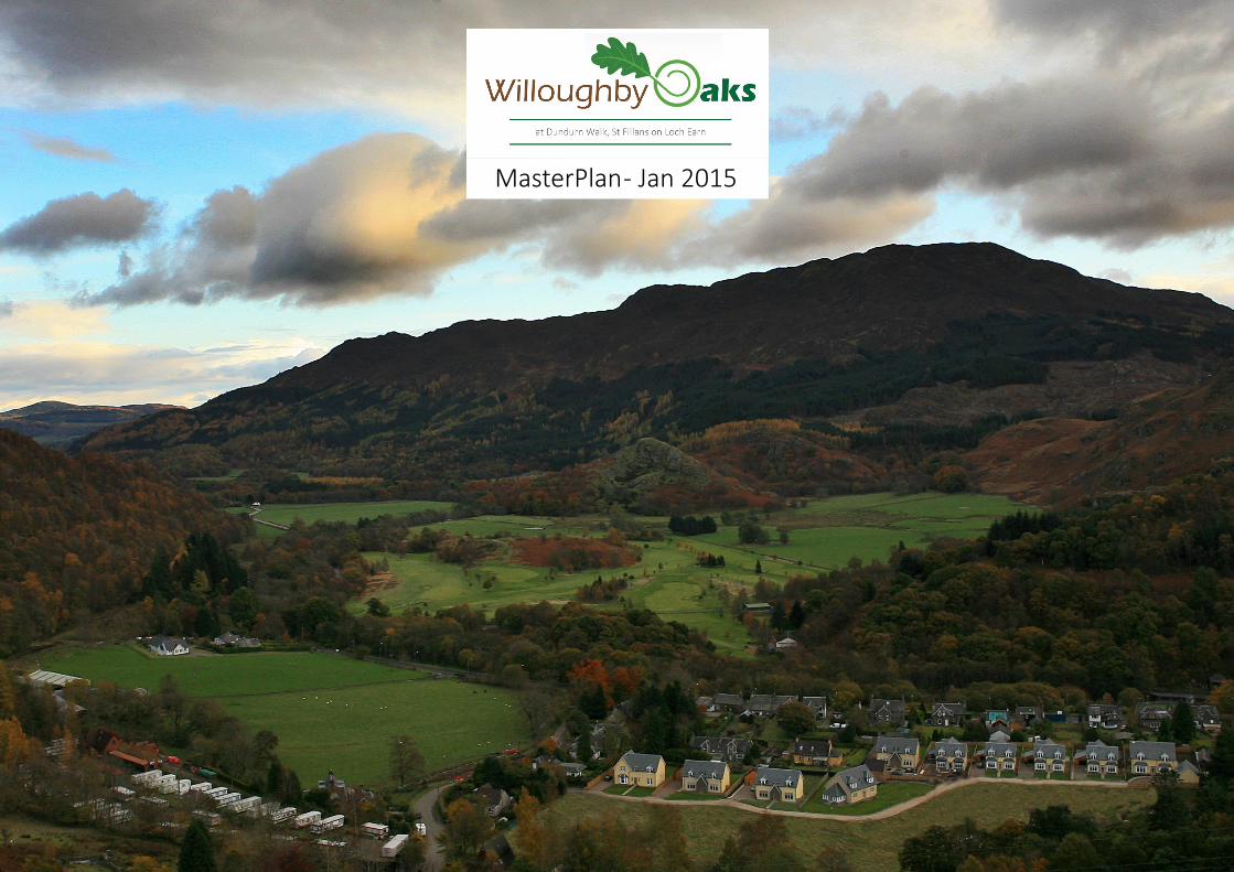
MasterPlan - Jan 2015

Contents
Introduction 3
SiteDescription 4
DesignStatement 5
MasterPlansBuildings 6Spaces 7Movement 8Combined 9
DetailedDesignDesign Brief & Materials 10Layout, Density & Mix 12Access & Connectivity 13Open Space & Landscaping 14Affordable Housing 15SUDS & Flooding 16Phasing & Aspirational Timeline 17
ComputerGeneratedSketches 18
ConsultationsConsultations 21Representations 22
Designing StreetsNational Roads Development GuidePAN 83 MasterPlanningSt Fillans Conservation AppraisalSPG - Affordable HousingCurrent Planning Application
please note these links open in a new window.

Introduction
ProjectSummary
ProjectNameWilloughby Oaks
DesignerBlack & Williams
ProjectTypeResidential development on edge of a Conservation Village within a National Park
LocationDundurn Walk, St Fillans, PH6 2NA
ClientWRFU Ltd (trading as Abhaile Homes)
PlanningAuthorityLoch Lomond & Trossachs National Park
MasterPlanAuthorMarcus SalterBlack & Williams - Jan 2015
Black & Williams has lodged a detailed planning application (2014/0237/DET) on behalf of Abhaile Homes for four detached houses to the North of Dundurn Walk, St Fillans.
In considering that application, the Planning Authority has requested the applicant address all the issues affecting a larger development of which these four properties are the starting point; hence the production of this document.
It is envisaged that this MasterPlan shall provide the Planning Authority with the necessary information to determine the current application and form the bedrock to another planning application for the entiriety of the site (identified in blue below).
Current application 2014/0237/DETwhole site .
3

St
Fillans
Allt a'
The
LB
Hotel
Struie Burn
Phuirt Bhig
FB
4
1
5
Limekiln
Little Port
Drummond
FBs
Earn View
Caravan Site
TCB
Tank
Field
Hall
Jetty
(um)Path
Tennis
Track
99.3m
99.0m
97.7m
98.6m
99.7m
Pump
Court
House
Paris
h
Shelter
Rose
Telephone
Shingle
Chur
ch
Playing
(disused)
Lake
Slipway
The Four
11
Exchange
Dund
urn
Holly
Neish
Path
(um
)
Seasons Hotel
Lochiel
Weirside
Birran
Cottage
Rosehill
Kirk
lea
Achray
The Firs
16
10
18
Plumtree
Ardchoille
Port Mor
Robi
nhill
Cardean
An Cala
West Hom
eThe W
hite
Bronwen
Ston
egat
eHill View
Brae
head
Maryfield
Charlotte
Longreach
Coachouse
Craig - Ard
Bracklyn
Altnabeag
Ardsheean
Inverearn
Dunollan
Earngrove
Oakbank
Cairndhu
Schoolhouse
Boltachan
Corranour
Glenalbyn
Shoemakers
Wellandura
Lochearnsid
e
Tighnacraig
Cherrybrae
Ratherenn
Old Church
Inerachray
Ardchattan
The Haven
Heatherlea
Dunbarney
Craigdarroch
Glengoynan
The
Coac
hous
e
MAN
SE L
ANE
Cra
igen
Hou
se
Deaitch Cottage
Achray Cottage
DUNDURN WALK
Tigh-Na-Mar
Corry Bruaiche
The Coach House
SHO
EMAK
ER'S
LAN
E
Glentarken Park
Earnbank
Oakbank
Path
Caravan Site
Hotel
Craigdarroch
Path (um)
Cot
tage
House
Glenalbyn
Cottage
TheDismantled Railway
1
Cottage
Cottage
Lay-by
4
A 85
LB
The
99.3m
Shingle
House
Cottage 1
House
FBs
Path
Cottage
The
Cottage
Cottage
Willoughby Oaks extends to 1.661 ha (4.105 acres) of unused former agricultural land that is zoned for housing development within the National Park Local Plan (H27) at the Eastern Edge of the village outwith the Conservation Area.
It has been subject to various successful Outline Planning Applications and other Detailed Planning Applications that were subsequently withdrawn during the slowdown in the Property Market.
The land sits to the North of the completed development of large luxury homes, known as Dundurn Walk and occupies a site to the West of Station Road sheltered from the busy A85 by the completed houses and traditional houses on the Road frontage to the South.
The site is undulating in nature, generally sloping up to the steep hills to the North and gradually down to a level field in the Western part of the site.
It is bordered by a public right of way to the North Boundary which forms a Core Path (upgraded as part of the proposals) and Mature Woodland to the North West, which is within the Woodland Management Plan.
In recent history the site can cause substantial water run-off onto Dundurn Walk during heavy downpours given its higher aspect and existing ground conditions.
Station Road
Dundurn Walk
Neish Island
Loch Earn
Village Shop
Willoughby Oaks
Core Path
Old Railway
A 85
Site Description
4
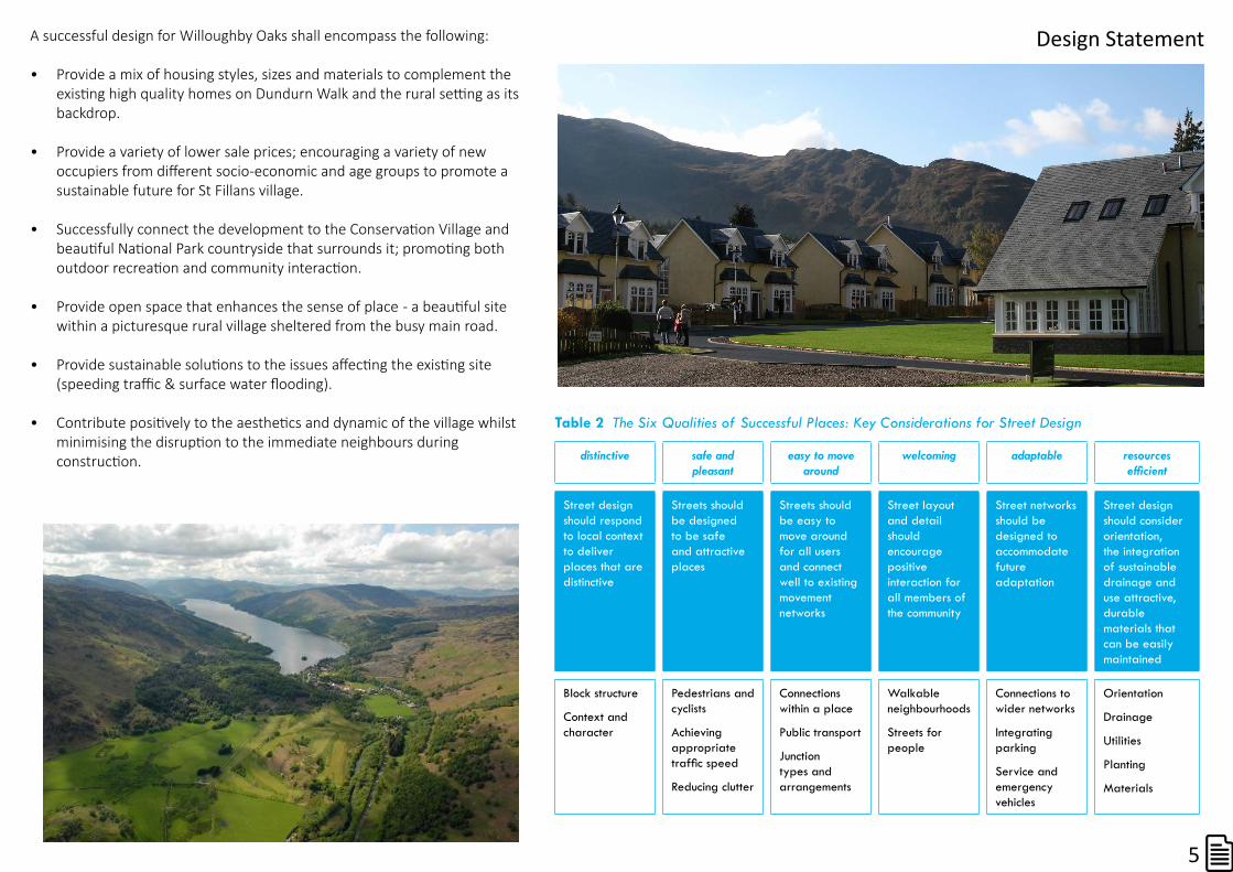
A successful design for Willoughby Oaks shall encompass the following:
• Provide a mix of housing styles, sizes and materials to complement the existing high quality homes on Dundurn Walk and the rural setting as its backdrop.
• Provide a variety of lower sale prices; encouraging a variety of new occupiers from different socio-economic and age groups to promote a sustainable future for St Fillans village.
• Successfully connect the development to the Conservation Village and beautiful National Park countryside that surrounds it; promoting both outdoor recreation and community interaction.
• Provide open space that enhances the sense of place - a beautiful site within a picturesque rural village sheltered from the busy main road.
• Provide sustainable solutions to the issues affecting the existing site (speeding traffic & surface water flooding).
• Contribute positively to the aesthetics and dynamic of the village whilst minimising the disruption to the immediate neighbours during construction.
Design Statement
Table 2 The Six Qualities of Successful Places: Key Considerations for Street Design
distinctive safe and pleasant
easy to move around
welcoming adaptable resources
Street design should respond to local context to deliver places that are distinctive
Streets should be designed to be safe and attractive places
Streets should be easy to move around for all users and connect well to existing movement networks
Street layout and detail should encourage positive interaction for all members of the community
Street networks should be designed to accommodate future adaptation
Street design should consider orientation, the integration of sustainable drainage and use attractive, durable materials that can be easily maintained
Block structure
Context and character
Pedestrians and cyclists
Achieving appropriate
Reducing clutter
Connections within a place
Public transport
Junction types and arrangements
Walkable neighbourhoods
Streets for people
Connections to wider networks
Integrating parking
Service and emergency vehicles
Orientation
Drainage
Utilities
Planting
Materials
5
1
19
20
21
22
23
25
27
29
24
26
28
30
31 - 36
Station Road
4
11
Sunset
18
West Hom
e
Hill View
Ardchattan
1
Dundurn Walk
2
3
4
12
17
1314
1516
37
38
41
3940
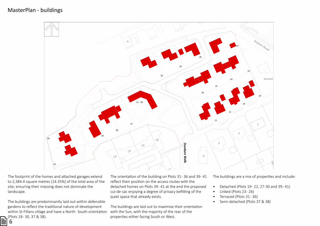
The footprint of the homes and attached garages extend to 2,384.4 square metres (14.35%) of the total area of the site; ensuring their massing does not dominate the landscape.
The buildings are predominantly laid out within defensible gardens to reflect the traditional nature of development within St Fillans village and have a North - South orientation (Plots 18 - 30, 37 & 38).
The orientation of the building on Plots 31 - 36 and 39 - 41 reflect their position on the access routes with the detached homes on Plots 39 - 41 at the end the proposed cul-de-sac enjoying a degree of privacy befitting of the quiet space that already exists.
The buildings are laid out to maximise their orientation with the Sun, with the majority of the rear of the properties either facing South or West.
The buildings are a mix of properties and include:
• Detached (Plots 19 - 22, 27-30 and 39 - 41)• Linked (Plots 23 - 26)• Terraced (Plots 31 - 36)• Semi-detached (Plots 37 & 38)
MasterPlan - buildings
6

1
19
20
21
22
23
25
27
29
24
26
28
30
31 - 36
Station Road
4
11
Sunset
18
West Hom
e
Hill View
Ardchattan
Corry Bruaiche
Dundurn Walk
2
3
4
12
17
1314
1516
37
38
41
3940
The open space within the development is split into two distinct categories and forms the majority of the land use, covering almost 70% of the development land, reflecting the sites situation on the rural edge of the village.
• Open Space 3,455.07 square metres (20.8%)• Private Gardens 8,056.84 square metres (48.51%)• Total Land Use 11,511.91 square metres (69.31%)
The Open Space at the heart of the site joins the existing built houses and the proposed homes enabling villagers and Dundurn Walk residents to relax and enjoy the stunning views on all sides.
There are plans for new tree planting to the East of the new road as it moves Northwards; with a large feature tree sited adjacent to the proposed Y junction.
The Open Space to the Northern boundary of the site accommodates the upgraded Core Path and continues down into a green corridor in the SW corner of the site with DDA compliant paths.
There are plans for a wildflower meadow to the North West (adjacent to the hammerhead) underneath the canopy of the existing trees in that corner; reducing the impact of the new built environment on the mature trees.
Adopted Open Spaceprivate gardens
MasterPlan - spaces
7

1
19
20
21
22
23
25
27
29
24
26
28
30
Station Road
4
11
Sunset
18
West Hom
e
Hill View
Ardchattan
Corry Bruaiche
Dundurn Walk
2
3
4
12
17
1314
1516
37
38
41
3940
The main access route is an adopted tarred Shared Access with 2m grass verges that recognises the priority of the pedestrian users and the emergence of Designing Streets policy.
The layout of the Shared Access has been designed to be aesthetically attractive, reduce forward visibility and displace vehicle traffic around low radius bends; forcing it to slow down.
The introduction of a loop road is in accordance with Designing Streets and the request of Perth & Kinross Council. It will mitigate the impact of the new development on the existing entrance to Dundurn Walk.
The S bend in the NE corner is designed to slow traffic down that enters and leaves the development as speeding delivery vans is a recognised problem affecting the existing Shared Access at Dundurn Walk.
There are private access roads off the shared access constructed from differing materials (gravel aggregate in grids enabling disabled access and promotion surfaced water drainage) offsetting the impact of the tar.
The layout has been designed to promote safe, attractive access throughout the new development; promoting interconnectivity with the village and countryside.
MasterPlan - movement
8

1
19
20
21
22
23
25
27
29
24
26
28
30
31 - 36
Station Road
4
11
Sunset
18
West Hom
e
Hill View
Ardchattan
1
Dundurn Walk
2
3
4
12
17
1314
1516
37
38
41
3940
1
19
20
21
22
23
25
27
29
24
26
28
30
31 - 36
Station Road
4
11
Sunset
18
West Hom
e
Hill View
Ardchattan
1
Dundurn Walk
2
3
4
12
17
1314
1516
37
38
41
3940
1
19
20
21
22
23
25
27
29
24
26
28
30
Station Road
4
11
Sunset
18
West Hom
e
Hill View
Ardchattan
1
Dundurn Walk
2
3
4
12
17
1314
1516
37
38
41
3940
The proposed site extends to 1.661 ha . 4.105 acres . 16,610 m2 and comprises:• Private garden 8,057m2 (48.50%)• Open Space 3,455m2 (20.80%)• Shared Access 2,714m2 (16.35%)• Building Footprints 2,384m2 (14.35%)
Significant care has been to taken to ensure the built environment recognises its setting on the rural edge of the village.
The proposed layout reflects the importance of open space, the need to provide a mix of dwellings whilst respecting buyer’s desires for defensible space and promotes outdoor recreation and community interaction through multiple access routes available to all users within the proposed development, existing development and village as a whole.
The following pages will now describe the proposals in greater detail.
MasterPlan - combined
9

In order to meet the objectives stated within the Design Statement and deliver a mix of housing styles attractive to a wider buying public the previous Design Brief for the proposed homes requires a little updating.
That design brief requires roof pitches with a minimum of 40 degrees, timber windows with a vertical emphasis and solid mullions, slate roofs and wet dash render.
The new proposals do not intend a stark contrast between the new homes and the existing development/village but they do suggest a different use of material combinations in clusters of the new homes, encouraging a mix of material finishes.
A mix of materials will provide much needed variety. contributing positively to a sense of place and avoiding a development of bland uniformity that besets many new housing ‘schemes’.
One of the significant changes to the design brief forced upon the developer is the replacement of timber windows with UPVC windows within the specification of new homes. New energy requirements within the Building Regulations make it increasingly diffi-cult to source timber windows that can meet the increasing energy standards whilst new home owners are put off by the maintenance requirements of timber windows.
Care has been taken in choosing a UPVC window profile that mimics the aesthetics of timber windows, whilst retaining timber doors and cladding to retain character.
1
19
20
21
22
23
25
27
29
24
26
28
30
31 - 36
Station Road
4
5
11
Sunset
18
West Hom
e
Hill View Schoolhouse
Ardchattan
Corry Bruaiche
1
Dundurn Walk
2
3
4
6
7
8
12
17
1314
1516 Station Road
37
38
41
3940
Cluster1
Cluster3
Cluster2
Cluster4
Cluster5
Design Brief
10
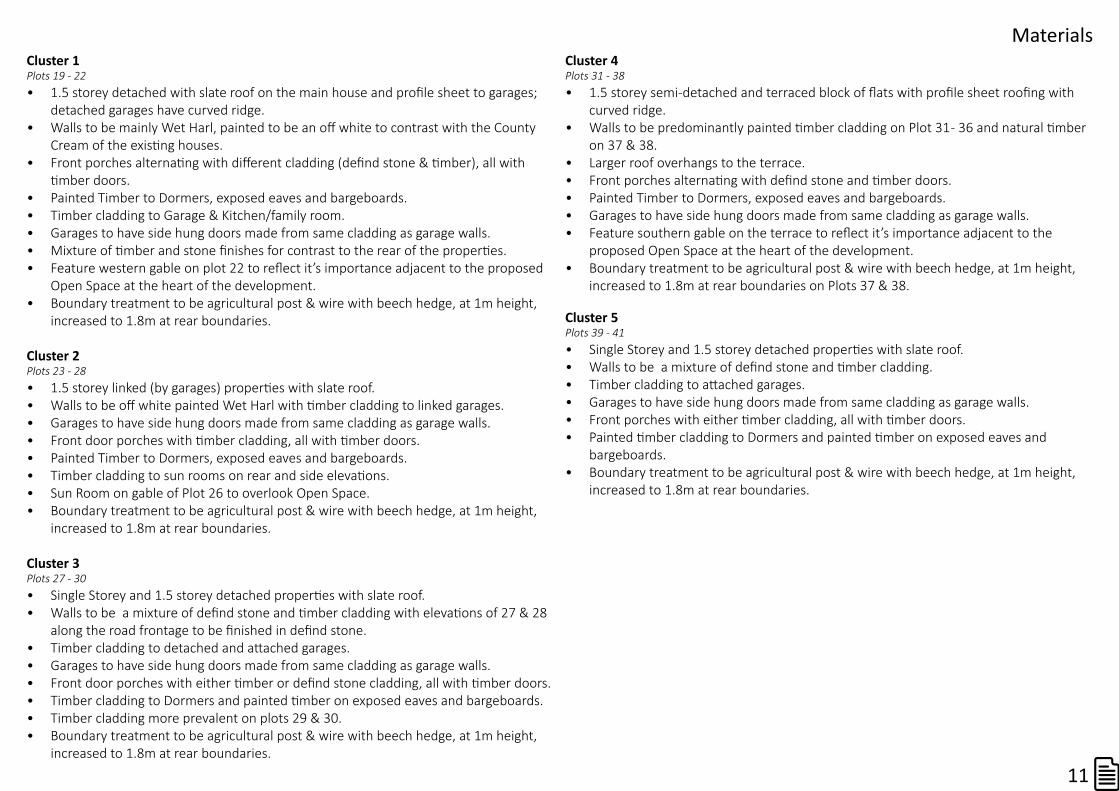
Cluster1Plots 19 - 22 • 1.5 storey detached with slate roof on the main house and profile sheet to garages;
detached garages have curved ridge.• Walls to be mainly Wet Harl, painted to be an off white to contrast with the County
Cream of the existing houses. • Front porches alternating with different cladding (defind stone & timber), all with
timber doors.• Painted Timber to Dormers, exposed eaves and bargeboards.• Timber cladding to Garage & Kitchen/family room.• Garages to have side hung doors made from same cladding as garage walls.• Mixture of timber and stone finishes for contrast to the rear of the properties.• Feature western gable on plot 22 to reflect it’s importance adjacent to the proposed
Open Space at the heart of the development.• Boundary treatment to be agricultural post & wire with beech hedge, at 1m height,
increased to 1.8m at rear boundaries.
Cluster2Plots 23 - 28• 1.5 storey linked (by garages) properties with slate roof.• Walls to be off white painted Wet Harl with timber cladding to linked garages.• Garages to have side hung doors made from same cladding as garage walls.• Front door porches with timber cladding, all with timber doors.• Painted Timber to Dormers, exposed eaves and bargeboards. • Timber cladding to sun rooms on rear and side elevations.• Sun Room on gable of Plot 26 to overlook Open Space.• Boundary treatment to be agricultural post & wire with beech hedge, at 1m height,
increased to 1.8m at rear boundaries.
Cluster3Plots 27 - 30• Single Storey and 1.5 storey detached properties with slate roof.• Walls to be a mixture of defind stone and timber cladding with elevations of 27 & 28
along the road frontage to be finished in defind stone.• Timber cladding to detached and attached garages.• Garages to have side hung doors made from same cladding as garage walls.• Front door porches with either timber or defind stone cladding, all with timber doors.• Timber cladding to Dormers and painted timber on exposed eaves and bargeboards. • Timber cladding more prevalent on plots 29 & 30.• Boundary treatment to be agricultural post & wire with beech hedge, at 1m height,
increased to 1.8m at rear boundaries.
Cluster4Plots 31 - 38• 1.5 storey semi-detached and terraced block of flats with profile sheet roofing with
curved ridge.• Walls to be predominantly painted timber cladding on Plot 31 - 36 and natural timber
on 37 & 38.• Larger roof overhangs to the terrace.• Front porches alternating with defind stone and timber doors.• Painted Timber to Dormers, exposed eaves and bargeboards.• Garages to have side hung doors made from same cladding as garage walls.• Feature southern gable on the terrace to reflect it’s importance adjacent to the
proposed Open Space at the heart of the development.• Boundary treatment to be agricultural post & wire with beech hedge, at 1m height,
increased to 1.8m at rear boundaries on Plots 37 & 38.
Cluster5Plots 39 - 41• Single Storey and 1.5 storey detached properties with slate roof.• Walls to be a mixture of defind stone and timber cladding.• Timber cladding to attached garages.• Garages to have side hung doors made from same cladding as garage walls.• Front porches with either timber cladding, all with timber doors.• Painted timber cladding to Dormers and painted timber on exposed eaves and
bargeboards. • Boundary treatment to be agricultural post & wire with beech hedge, at 1m height,
increased to 1.8m at rear boundaries.
Materials
11

A greater mix of housing types is encouraged by the planning authority and help bring in a wide range of home occupiers, helping deliver a sustainable future for St Fillans.
The developer has attempted to consider this in their plans whilst delivering
detached properties that are preferred by home buyers and smaller properties that would appeal to a wider buying public.
The largest element of the housing mix is still detached homes within defensible gardens; however, they account for less than half of the units and the proposals include a wide range of smaller house types than those previously built on site.
• Detached1Storey - 2 units (8.7%)Plots 27 & 39
• Detached1.5Storey- 9 units (39.1%)Plots 19 - 22, 28 - 30 & 40 - 41
• Linked1.5Storey - 4 units (17.4%)Plots 23 - 26
• Semi1.5Storey - 2 units (8.7%)Plots 37 & 38
• Terraced1.5Storey - 6 units (26.1% Plots 31 - 36
1
19
20
21
22
23
25
27
29
24
26
28
30
31 - 36
Station Road
4
11
Sunset
18
West Hom
e
Hill View
Ardchattan
1
Dundurn Walk
2
3
4
12
17
1314
1516
37
38
41
3940
1
19
20
21
22
23
25
27
29
24
26
28
30
31 - 36
Station Road
4
11
Sunset
18
West Hom
e
Hill View
Ardchattan
1
Dundurn Walk
2
3
4
12
17
1314
1516
37
38
41
3940
1
19
20
21
22
23
25
27
29
24
26
28
30
Station Road
4
11
Sunset
18
West Hom
e
Hill View
Ardchattan
1
Dundurn Walk
2
3
4
12
17
1314
1516
37
38
41
3940
The proposed site extends to 1.661 ha (4.105 acres) and comprises of:• Private garden 8,057m2 (48.50%)• Open Space 3,455m2 (20.80%)• Shared Access 2,714m2 (16.35%)• Building Footprints 2,384m2 (14.35%)
The proposals are for 23 units (including 6 flats) equating to: • 13.85 units per hectare.• 5.6 units per acre.
The building’s combined footprint have the following ratios:• footprint to development site - 1:6.97• footprint to plots - 1:4.38
Whilst many observers focus on the number of units within a development, unit numbers alone are not an accurate measurement of density within a development.
It is apparent from the analysis above that the proposed density of building within the development is relatively low, accounting for only 14.35% of the land use.
The amount of land set aside as Open Space open to use of the public is high at 37.15%; and significantly greater than on the previous development. That figure includes 20.80% of designated Open Space.
The proposed land use results in a medium density in a layout that compliments the situation of the development and its surrounding and vistas.
Housing Mix
Layout & Density
12
1
19
20
21
22
23
25
27
29
24
26
28
30
Station Road
4
5
11
Sunset
18
West Hom
e
Hill View Schoolhouse
Ardchattan
Corry Bruaiche
1
Dundurn Walk
2
3
4
6
7
8
12
17
1314
1516 Station Road
37
38
41
3940
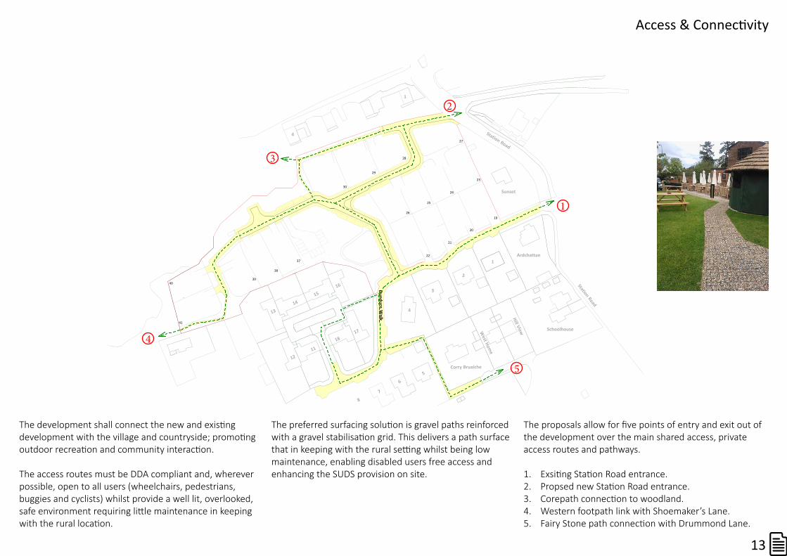
The development shall connect the new and existing development with the village and countryside; promoting outdoor recreation and community interaction.
The access routes must be DDA compliant and, wherever possible, open to all users (wheelchairs, pedestrians, buggies and cyclists) whilst provide a well lit, overlooked, safe environment requiring little maintenance in keeping with the rural location.
The preferred surfacing solution is gravel paths reinforced with a gravel stabilisation grid. This delivers a path surface that in keeping with the rural setting whilst being low maintenance, enabling disabled users free access and enhancing the SUDS provision on site.
The proposals allow for five points of entry and exit out of the development over the main shared access, private access routes and pathways.
1. Exsiting Station Road entrance.2. Propsed new Station Road entrance.3. Corepath connection to woodland.4. Western footpath link with Shoemaker’s Lane.5. Fairy Stone path connection with Drummond Lane.
1
3
2
4
5
Access & Connectivity
13

1
19
20
21
22
23
25
27
29
24
26
28
30
31 - 36
Station Road
4
11
Sunset
18
West Hom
e
Hill View
Ardchattan
Corry Bruaiche
Dundurn Walk
2
3
4
12
17
1314
1516
37
38
41
3940
As the character of the streetscape of St Fillans is basic, we do not propose to introduce highly designed surfaces, street furniture, lighting or signage.
Mature trees are an important element of the landscape and make a positive contribution to its special character; our plans incorporate the protection and maintenance of the mature established trees to the NW of the site (5) and significant tree planting in all the open spaces.
A landscape plan shall accompany the detailed planning application for the rest of the site but it is hoped that the St Fillans Community will consider adopting and taking ownership of the designated open space once it has been established.
Perth & Kinross Council have a procedure for adopting the open space, should the Community choose not to.
The community shall be consulted in regards to the final design and specification of planting and design of the open spaces; however, the proposals envisage:1. Parkland Open Space with feature tree planting to the
West of plots 22 & 26.2. Core path upgrading.3. Wildflower meadow.4. Tree lined avenue.5. Presevation of existing mature trees.
1
3
2
4
5
The Detailed Planning applciation for plots 23 - 41 will include an updated Woodland Management Plan for the established woodland to the North West of the site (5).
Landscaping & Open Space
14

1
19
20
21
22
23
25
27
29
24
26
28
30
31 - 36
Station Road
4
5
11
Sunset
18
West Hom
e
Hill View Schoolhouse
Ardchattan
Corry Bruaiche
1
Dundurn W
alk
2
3
4
6
7
8
12
17
1314
1516 Station Road
37
38
41
3940
There is a requirement for the developer to provide an element of Affordable Housing on site amounting to 25% of the proposed housing units.
Perth & Kinross Council are the provider of Affordable Housing within St Fillans and they have established that there is no demand for affordable housing within St Fillans. Additionally, there is no government subsidy available for onsite provision.
Accordingly, PKC have recommended the developer pay a Commuted Sum of £19,000 per affordable housing unit for the provision of affordable housing offsite within Perth & Kinross.
Under these proposals the commuted sum equates to (0.25*23) * £19,000 = £109,250.
The Planning Authority, the National Park, have requested the developer consider providing the Affordable Housing onsite without a government subsidy.
The developer’s agent has met with Rural Stirling Housing Association in their role as a Rural Housing Enabler for advice and guidance. RSHA consider carrying out a Housing Needs Survey to establish the demand for affordable housing as the way to move forwards.
The developer has concerns that this will unnecessarily prolong matters and deliver inconclusive results.
It is clear from the National Park’s Supplementary Planning Guidance that there are two options open to the Developer for the provision of affordable housing onsite without any government subsidy:
1. Homes for Mid-Market Rent.2. Unsubsidised Shared Equity.
These proposals consider the provision of unsubsidised Shared equity on 6 flats on plots 31 - 36.
The maximum price the owner can pay for his part in the equity of the property will not exceed 3.5 times the median income level within the relevant Perth & Kinross.
The median income for Perth & Kinross is £27,598. Therefore the maximum price the owner can pay for their 70% equity share is £27,598 * 3.5 = £96,593.
It has yet to be established what shall constitute an eligible purchaser, how long the developer shall be required to hold the 30% equity stake for and what happens in the event there is no demand for the proposed flatted units from eligible buyers.
Further discussion is required, but the developer remains open to the idea of provision of affordable housing in the form of six 2bed flats on plots 31 - 36 site as a result of the encouragement from the planning authority to do so.
Affordable Housing
15

1
19
20
21
22
23
25
27
29
24
26
28
30
31 - 36
Station Road
4
5
11
Sunset
18
West Hom
e
Hill View Schoolhouse
Ardchattan
Corry Bruaiche
1
Dundurn Walk
2
3
4
6
7
8
12
17
1314
1516 Station Road
37
38
41
3940
The site is not at risk of flooding from either the River Earn or Struie Burn, but pluvial flooding remains a significant issue on site; so finished floor levels will be significantly higher than ground levels to reduce the impact of onsite pluvial flooding.
Ground conditions on site are such that underneath a capping layer, there is free draining subsoil. Previous development that captured the surface water and diverted
it into the subsoil has proven very successful and reduced the instances of pluvial flooding.
Each dwelling shall have its own engineer designed soakaway. The Shared Access will have an engineer designed soakaway (5) to divert surface water into the free draining subsoil.
With the surface water from the roofs and road being
diverted into free draining subsoil, the amount of surface water runoff within the development shall be reduced by over 30%.
In addition we plan to design a surface water collection system (1 - 4) to collect surface water and divert in into the underground communal soakaway manhole rings (5) which shall be adopted by the Perth & Kinross roads department.
1
3
2
4
5
Flooding & SUDS
16

1
19
20
21
22
23
25
27
29
24
26
28
30
31 - 36
Station Road
4
5
11
Sunset
18
West Hom
e
Hill View Schoolhouse
Ardchattan
Corry Bruaiche
1
Dundurn Walk
2
3
4
6
7
8
12
17
1314
1516 Station Road
37
38
41
3940
Aspirational Timeline & Phasing
Cluster1
Cluster3
Cluster2
Cluster4
Cluster5
Jan - March April - Jun Jul - Sep Oct - Dec Jan - March April - Jun Jul - Sep Oct - Dec Jan - March April - Jun Jul - Sep Oct - Dec Jan - March April - Jun Jul - Sep Oct - Dec
Shared Access & Open Space
Cluster 2
Cluster 4
Cluster 5
Pumping Station & SUDS
2015 2016 2017 2018
Cluster 1
Cluster 3
17

Computer Generated Sketches
existing homes
open space
plot 22
current application
future homes
18
Birds-eyeviewfromtheEastlookingNorthWest.
The four properties forming part of the existing planning application are shown in the centre, with the existing houses to the left of the sketch and future housing to the rear.
Please note, these sketches are indicative only and do not reflect the levels of the site. An accurate CGI will
accompany the Detailed Planning Application.
Birds-eyeviewfromtheWestlookingNorthEast.
The large Open Space in the heart of the development is in the centre of the sketch, with trees planted to the East of the Shared Access. The feature gable of plot 22 overlooking the Open Space is visible.
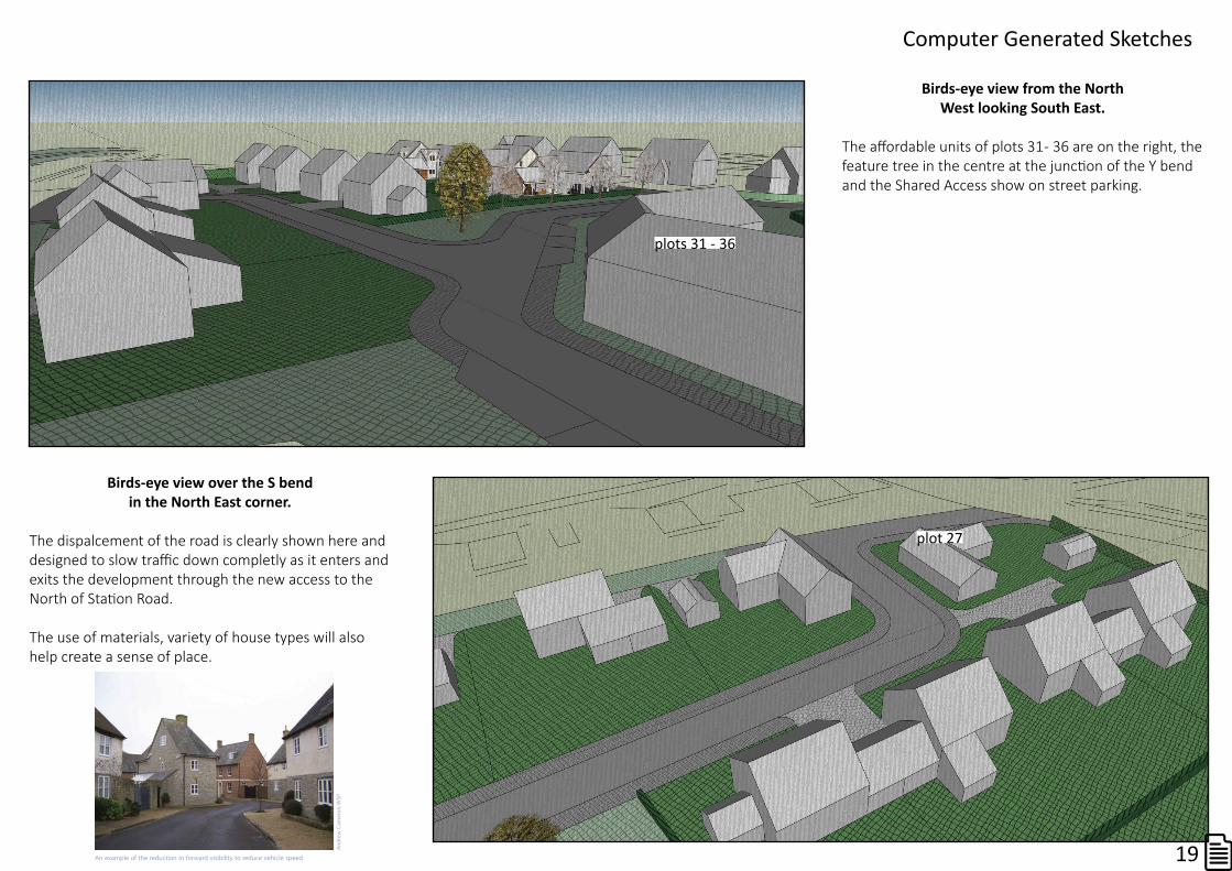
Birds-eyeviewfromtheNorthWestlookingSouthEast.
The affordable units of plots 31 - 36 are on the right, the feature tree in the centre at the junction of the Y bend and the Shared Access show on street parking.
plots 31 - 36
plot 27
Computer Generated Sketches
19
Birds-eyeviewovertheSbendintheNorthEastcorner.
The dispalcement of the road is clearly shown here and designed to slow traffic down completly as it enters and exits the development through the new access to the North of Station Road.
The use of materials, variety of house types will also help create a sense of place.
visibility in conjunction with other methods to control tra�c speeds.
An example of the reduction in forward visibility to reduce vehicle speed
And
rew
Cameron
WSP

ConsultationsTo date the only statutory consultees to re-spond to the planning application are:
PerthEnvironmentalHealth- no objection. No perceived loss of amenity to nearby dwelling houses.
Perth&KinrossFlooding - initially suggested the development was at medium to high risk and a Flood Risk Assessment was required. Subsequently removed the requirement for a Flood Risk Assessment once they had been made aware of SEPAs consultation and previous Flood Risk Assessments for the site. Guidance is now - ‘If you can demonstrate that the ffl is slightly higher than existing ground level then that would be sufficient for me to not object to planning on the grounds of flood risk’.
SEPA - no objection and clarity given regarding erroneous flood map.
StFillansCommunityCouncil - representation not received yet as extension granted to enable developer to carry out further consultation and present the DRAFT MasterPlan.
The Community Council representation must reflect the views of the whole community and it is hoped this is respected despite three members of the Community Council registering personal representations.
It is clear, through our own consultations, that the majority of villagers are agnostic to the development but all are concerned that site specific issues are addressed and the development contributes positively to the village.
During the determination of the current application, it was clear that many of the site wide issues needed to be addressed.
At the request of the National Park the developer has held further consultation meetings with the following bodies, before finalising our proposals.• Perth & Kinross Open Spaces• Perth & Kinross Transportation• Perth & Kinross Flooding• Local Councillor Rhon Brock• St Fillans Village• Rural Stirling Housing Association.
The attendance of the St Fillans public meeting was not well attended but two of those who made representations did attend and it was encouraging to have a positive discourse.
The feedback from the public meeting was generally positive with people acknowledging development would happen but the following issues needed to be addressed:
1. Detail the known and aspirational timeframe for the development.
2. Detail the timeframe for delivery of the surface water drainage elements and sewerage pumping station.
3. Confirm a connecting road through to Shoemaker’s lane is not proposed.
4. Confirm that there shall be a mix of external finishes that contrast and compliment the existing development, avoiding the development becoming a ‘yellow boil’ at the edge of the village.
It is hoped all this points have been addressed within this MasterPlan
20
Representations
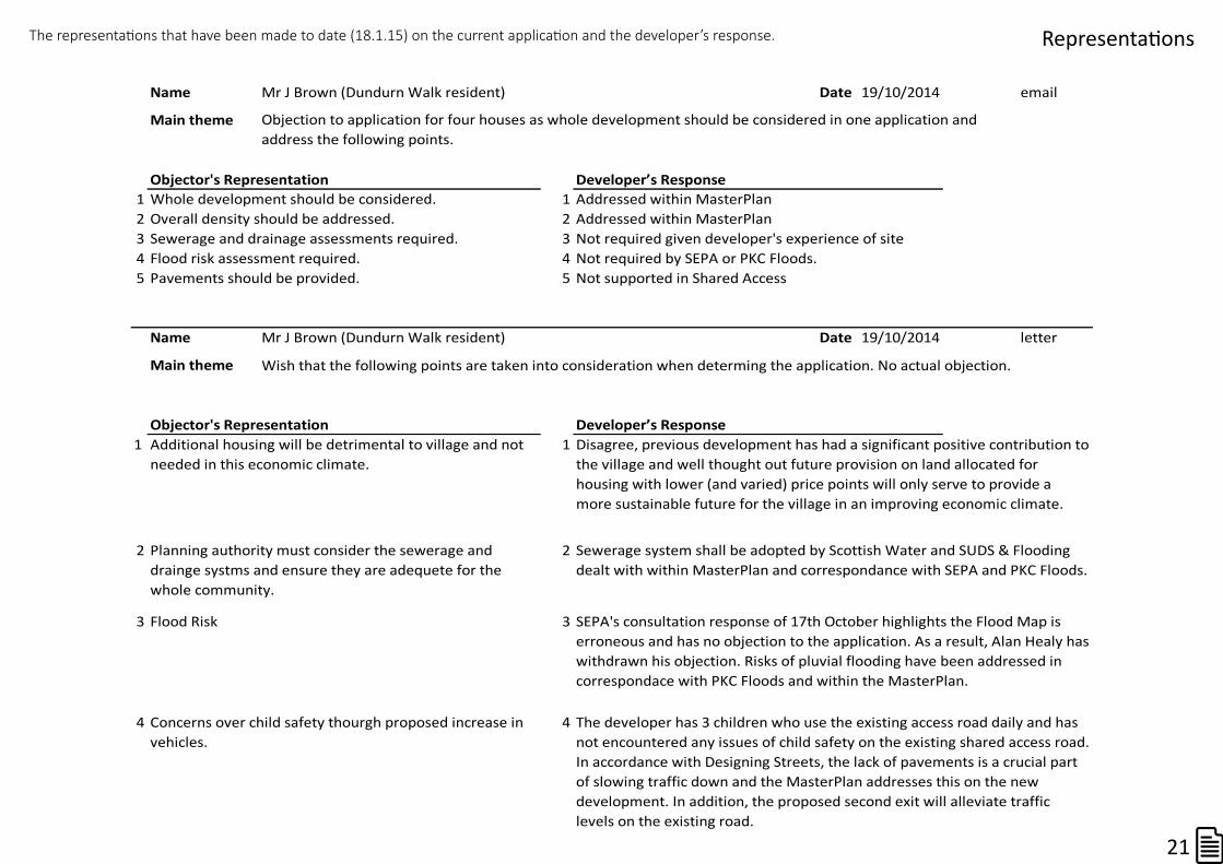
Name Mr J Brown (Dundurn Walk resident) Date 19/10/2014 email
Main theme
Objector's Representation Developer’s Response1 Whole development should be considered. 1 Addressed within MasterPlan2 Overall density should be addressed. 2 Addressed within MasterPlan3 Sewerage and drainage assessments required. 3 Not required given developer's experience of site4 Flood risk assessment required. 4 Not required by SEPA or PKC Floods.5 Pavements should be provided. 5 Not supported in Shared Access
Name Mr J Brown (Dundurn Walk resident) Date 19/10/2014 letter
Main theme
Objector's Representation Developer’s Response1 1
2 2
3 Flood Risk 3
4 4Concerns over child safety thourgh proposed increase in vehicles.
The developer has 3 children who use the existing access road daily and has not encountered any issues of child safety on the existing shared access road. In accordance with Designing Streets, the lack of pavements is a crucial part of slowing traffic down and the MasterPlan addresses this on the new development. In addition, the proposed second exit will alleviate traffic levels on the existing road.
SEPA's consultation response of 17th October highlights the Flood Map is erroneous and has no objection to the application. As a result, Alan Healy has withdrawn his objection. Risks of pluvial flooding have been addressed in correspondace with PKC Floods and within the MasterPlan.
Objection to application for four houses as whole development should be considered in one application and address the following points.
Wish that the following points are taken into consideration when determing the application. No actual objection.
Disagree, previous development has had a significant positive contribution to the village and well thought out future provision on land allocated for housing with lower (and varied) price points will only serve to provide a more sustainable future for the village in an improving economic climate.
Additional housing will be detrimental to village and not needed in this economic climate.
Planning authority must consider the sewerage and drainge systms and ensure they are adequete for the whole community.
Sewerage system shall be adopted by Scottish Water and SUDS & Flooding dealt with within MasterPlan and correspondance with SEPA and PKC Floods.
The representations that have been made to date (18.1.15) on the current application and the developer’s response.
21
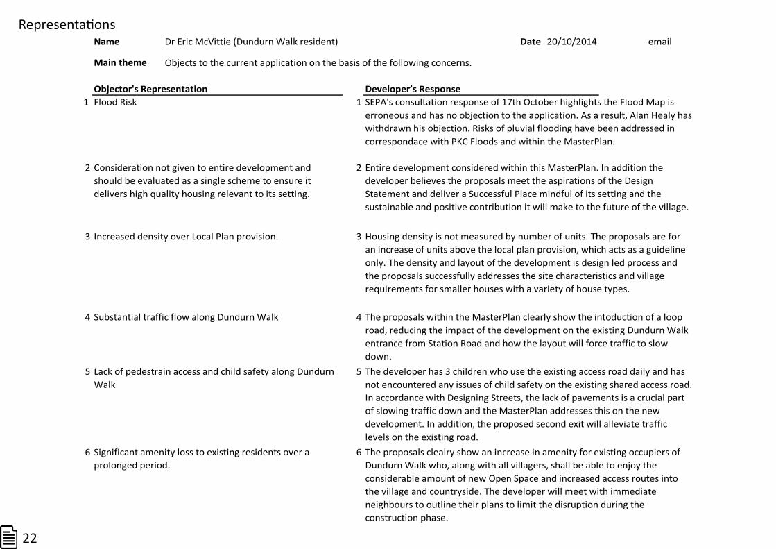
RepresentationsName Dr Eric McVittie (Dundurn Walk resident) Date 20/10/2014 email
Main theme
Objector's Representation Developer’s Response1 1
2 2
3 3
4 4
5 5
6 6
Lack of pedestrain access and child safety along Dundurn Walk
The developer has 3 children who use the existing access road daily and has not encountered any issues of child safety on the existing shared access road. In accordance with Designing Streets, the lack of pavements is a crucial part of slowing traffic down and the MasterPlan addresses this on the new development. In addition, the proposed second exit will alleviate traffic levels on the existing road.
Objects to the current application on the basis of the following concerns.
SEPA's consultation response of 17th October highlights the Flood Map is erroneous and has no objection to the application. As a result, Alan Healy has withdrawn his objection. Risks of pluvial flooding have been addressed in correspondace with PKC Floods and within the MasterPlan.
Consideration not given to entire development and should be evaluated as a single scheme to ensure it delivers high quality housing relevant to its setting.
Entire development considered within this MasterPlan. In addition the developer believes the proposals meet the aspirations of the Design Statement and deliver a Successful Place mindful of its setting and the sustainable and positive contribution it will make to the future of the village.
Substantial traffic flow along Dundurn Walk The proposals within the MasterPlan clearly show the intoduction of a loop road, reducing the impact of the development on the existing Dundurn Walk entrance from Station Road and how the layout will force traffic to slow down.
Flood Risk
Increased density over Local Plan provision. Housing density is not measured by number of units. The proposals are for an increase of units above the local plan provision, which acts as a guideline only. The density and layout of the development is design led process and the proposals successfully addresses the site characteristics and village requirements for smaller houses with a variety of house types.
Significant amenity loss to existing residents over a prolonged period.
The proposals clealry show an increase in amenity for existing occupiers of Dundurn Walk who, along with all villagers, shall be able to enjoy the considerable amount of new Open Space and increased access routes into the village and countryside. The developer will meet with immediate neighbours to outline their plans to limit the disruption during the construction phase.
22

RepresentationsName Dr & Mrs Forrester (Dundurn Walk residents) Date 20/10/2014 letter
Main theme
Objector's Representation Developer’s Response1 1
2 2
3 3
4 4
No objection in principle but following issues should be addressed.
Consideration not given to entire development and should be evaluated as a single scheme.
Entire development considered within this MasterPlan.
Flood Risk SEPA's consultation response of 17th October highlights the Flood Map is erroneous and has no objection to the application. As a result, Alan Healy has withdrawn his objection. Risks of pluvial flooding have been addressed in correspondace with PKC Floods and within the MasterPlan.
Ensure drainage infrastructure is fit for purpose for entire development.
Sewerage system shall be adopted by Scottish Water and SUDS & Flooding dealt with within MasterPlan and correspondance with SEPA and PKC Floods.
Concerns over child safety thourgh proposed increase in vehicles.
The developer has 3 children who use the existing access road daily and has not encountered any issues of child safety on the existing shared access road. In accordance with Designing Streets, the lack of pavements is a crucial part of slowing traffic down and the MasterPlan addresses this on the new development. In addition, the proposed second exit will alleviate traffic levels on the existing road.
23

Name Mr Paul Aitken (Dundurn Walk residents) Date 21/10/2014 email
Main theme
Objector's Representation Developer’s Response1 1
2 2
3 3
4 4
5 56 6
Raises the following concerns.
Lack of information regarding roads & footways Not required for application for initial 4 houses but MasterPlan highlights the proposals for the Shared Access for the whole development.
No proposals for overall scheme provided MasterPlan addresses this.Applicants do not have a good reputation for quality of work and attendance to client's concerns.
This point is irrelevant to planning concerns.
Concerns over child safety thourgh lack of pavement provision.
The developer has 3 children who use the existing access road daily and has not encountered any issues of child safety on the existing shared access road. In accordance with Designing Streets, the lack of pavements is a crucial part of slowing traffic down and the MasterPlan addresses this on the new development. In addition, the proposed second exit will alleviate traffic levels on the existing road.
No drainage proposals submitted. Sewerage system shall be adopted by Scottish Water and SUDS & Flooding dealt with within MasterPlan and correspondance with SEPA and PKC Floods.
Existing development flooding and remedial work required.
Issues of pluvial flooding addressd within the MasterPlan. The proposals within the MasterPlan are based on developer's experience of helping to successfully design and implement the remedial work described by Mr Aitken.
Representations
24


