County of Simcoe – Materials Management Facility Part 2 – Long List Evaluation County of Simcoe Solid Waste Management Department 1110 Highway 26 Midhurst, Ontario L0L 1X0 County of Simcoe 184 Front Street East, Suite 302 Toronto Ontario M5A 4N3 086822 | Report No 5 | July 2015
Transcript
County of Simcoe – Materials Management FacilityPart 2 – Long List EvaluationCounty of SimcoeSolid Waste Management Department1110 Highway 26Midhurst, OntarioL0L 1X0 County of Simcoe 184 Front Street East, Suite 302 Toronto Ontario M5A 4N3086822 | Report No 5 | July 23 2015
GHD | County of Simcoe – Materials Management Facility – Part 2 – Long List Evaluation | 086822 (5) | i
Executive Summary
The County of Simcoe's (County) Solid Waste Management Strategy (Strategy) was approved by Council in 2010, and provides the framework for the County's waste disposal options and diversion programs. Regarding the transfer of materials, the Strategy recommended assessing long-term transfer requirements based on the status of contracts for collection, processing of organics and recycling and waste export.
New contracts began for curbside collection, transfer of recycling, and waste export in 2013. Currently, the County transfers approximately 25,000 tonnes per year of curbside garbage for processing, 10,000 tonnes per year of source-separated organics, and over 25,000 tonnes per year of recycling (paper fibres and containers).
With detailed information on transfer costs, a financial analysis for a County transfer facility was presented to County Council in August 2014. It outlined the contracted costs for transfer, the estimated capital costs for the building, and the potential for funding from the Continuous Improvement Fund (CIF). The financial analysis determined that a County MMF could save approximately $13 million over the next 20 years compared to the current system. Further to this, in August 2014, County Council endorsed work by GHD Limited (GHD) [formerly Conestoga-Rovers & Associates (CRA)], to determine the optimal site for a County transfer facility (Study). To more accurately reflect the nature of this Study, the term transfer facility was replaced with Materials Management Facility (MMF).
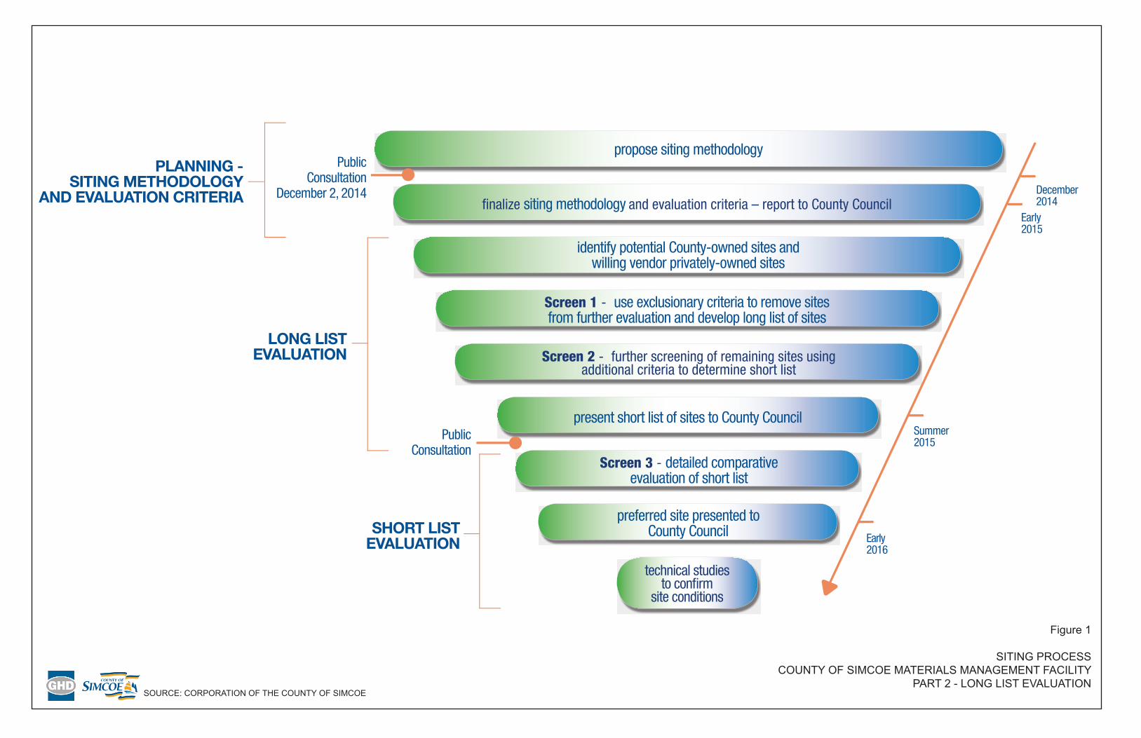
The siting process was initiated by GHD in November 2014. In order to facilitate the identification of a preferred location for the MMF, it was proposed that the siting process occur in three major stages:
Part 1 – Planning – Siting Methodology and Evaluation Criteria
Part 2 – Long List Evaluation
Part 3 – Short List Evaluation
Each of the above parts represents a separate, stand-alone report that will be submitted to Council for direction prior to proceeding with the next stage.
Following stakeholder consultation through a Community Engagement Committee (CEC) and Public Open Houses, the Part 1 Report, Planning – Siting Methodology and Evaluation Criteria, was submitted for Council approval on February 26, 2015. An overview of the report was also presented to Council by GHD on the same day. On March 10, 2015, County Council endorsed the siting methodology and evaluation criteria for the MMF, allowing work to proceed on Part 2, the Long List Evaluation. The main objective of this report is to present the findings of Part 2 – Long List Evaluation, including:
• The determination of a complete list of candidate sites including both County-owned sites and privately-owned sites.
• A review of the evaluation criteria including their definitions, data sources, and exemptions.
• The application of Screen 1 criteria to the list of candidate sites to generate a long list of sites.
GHD | County of Simcoe – Materials Management Facility – Part 2 – Long List Evaluation | 086822 (5) | ii
• The application of Screen 2 criteria to the long list of sites to generate a short list of sites.
• A description of how stakeholder feedback was addressed and incorporated into the project.
• A discussion of the next steps in the siting process, including presentation of the results to County Council, meeting with the Community Engagement Committee, and the public consultation plan in regards to the short-listed sites.
A comprehensive list of candidate sites was developed from two main sources: County-owned sites (such as open and closed landfills and County forest tracts) and privately-owned sites from willing vendors, sought through a search of the Multiple Listing Service (MLS) of the Canadian Real Estate Association (CREA) and a formal Request for Expressions of Interest (RFEI) process.
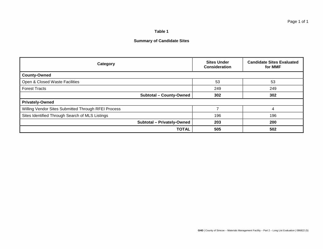
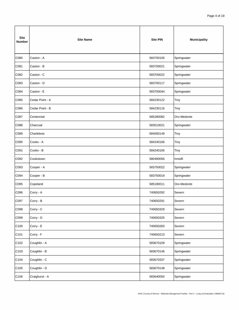
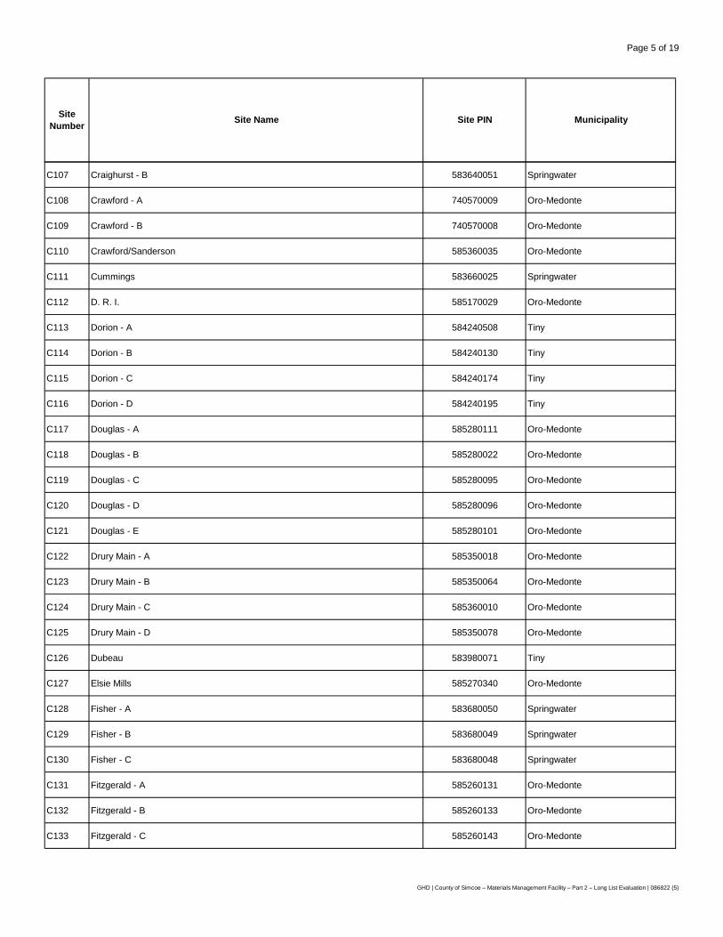
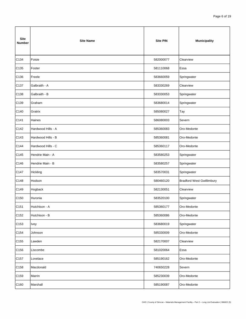
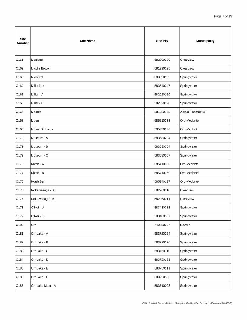
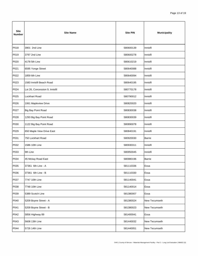
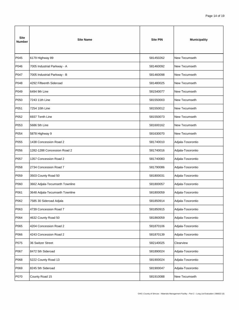
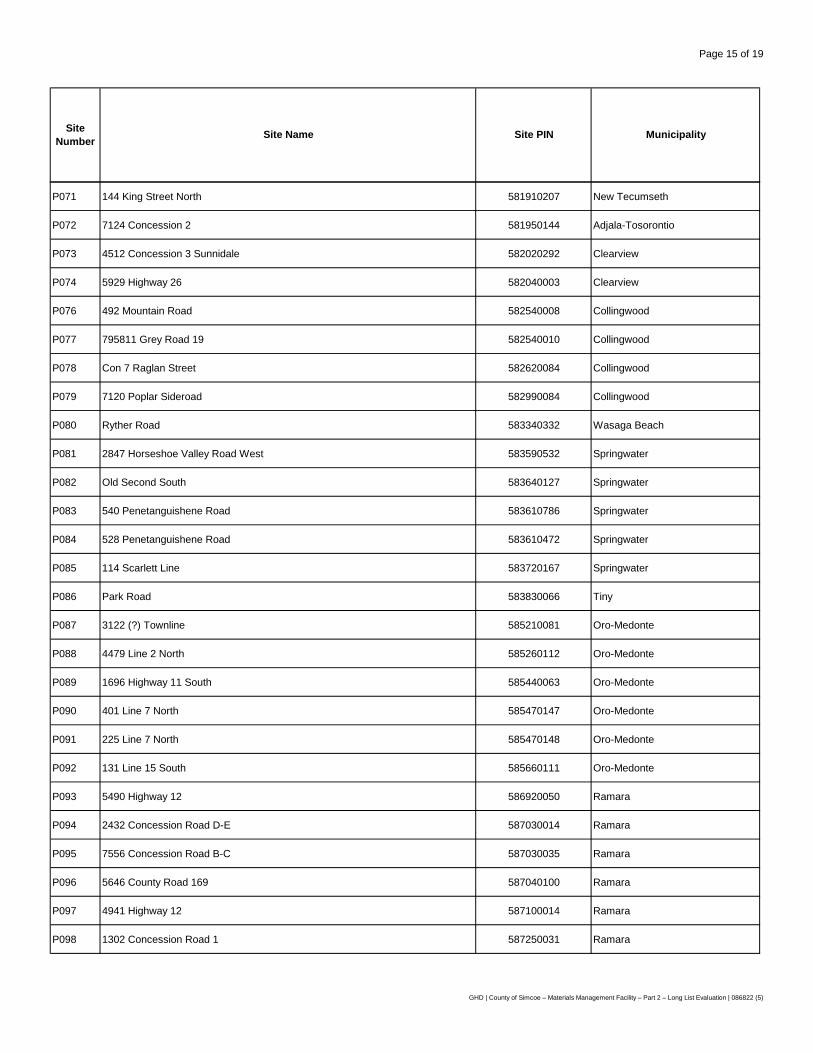
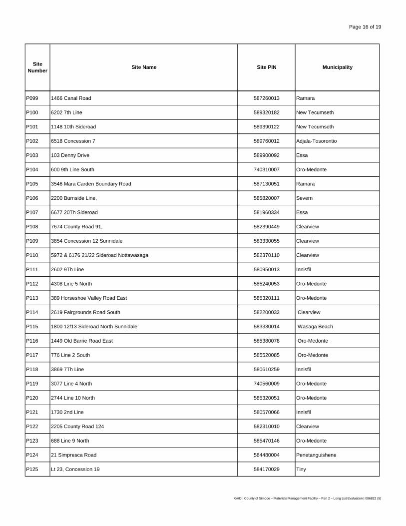
A total of 505 sites were identified for consideration. All of the County-owned sites under consideration were evaluated, whereas only 4 of the willing vendor sites submitted through the RFEI process met the requirements for the MMF. As a result, the final list of candidate sites evaluated for the MMF includes 302 County-owned sites, and 200 privately-owned sites, for a total of 502. This list of sites was then evaluated against the Screen 1 criteria.
Screen 1 consists of a number of exclusionary criteria, which a given site must satisfy in order to be carried forward for further evaluation. The exclusionary criteria are based largely on the technical requirements of an MMF facility that meet the program needs set out by the County, and provide a minimum threshold that a site must meet in order to be considered. A total of 23 sites were carried forward to the long list evaluation in Screen 2.
Screen 2 builds on the exclusionary criteria and focuses on key criteria that can be used to differentiate the long list of sites, including additional avoidance criteria (i.e., from sensitive receptors due to odour, noise, etc.) and site suitability criteria. Each criterion was assigned either a favourable, neutral, or unfavourable rating for each site. A site that received more favourable ratings (i.e., greater number of advantages) was considered to be preferred over another site which received fewer favourable ratings.
Five of the 23 long-listed MMF sites assessed through the application of Screen 2 criteria comprise the short list of sites. The five short-listed sites are:
• Site C164/C107 – County-Owned – Millenium/Craighurst Forest Tracts.
• Site C136 – County-Owned – Freele Forest Tract.
• Site C223 – County-Owned – Sandford Forest Tract.
• Site C270 – County-Owned – Unnamed Forest Tract.
• Site P083/P084 – Privately-Owned – 540/528 Penetanguishene Road.
These short-listed sites will be carried forward for further detailed comparative evaluation as part of Screen 3 (Part 3). The comparative evaluation will consider the potential effects, control measures (i.e., avoidance, mitigation, compensation and/or enhancement measures), and the net effects for all of the established criteria and indicators. The sites will then be compared against one another and ranked, and the preferred site will be identified based on the appropriate balance of strengths (advantages) and weaknesses (disadvantages) and how well the site satisfies the goals and objectives of the project.
GHD | County of Simcoe – Materials Management Facility – Part 2 – Long List Evaluation | 086822 (5) | iii
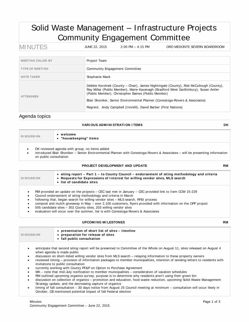
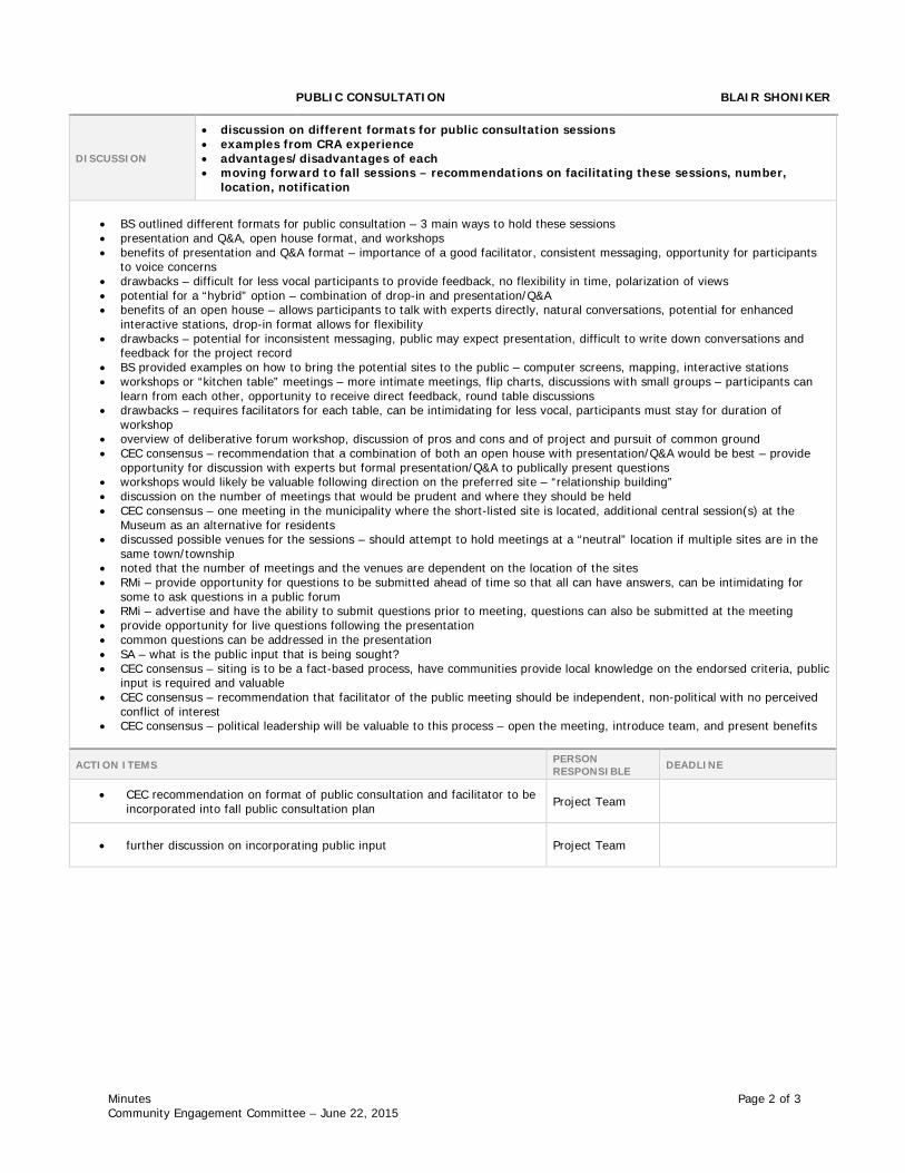
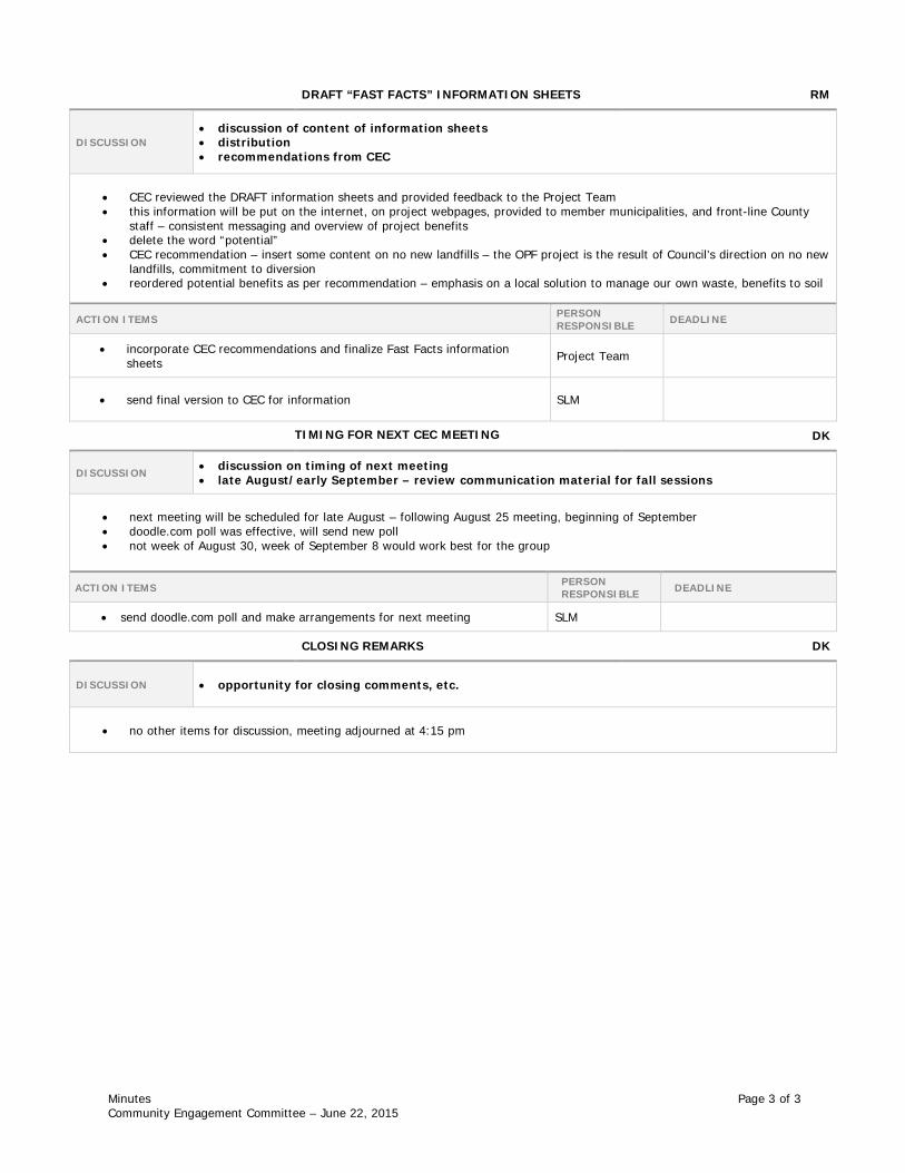
The Community Engagement Committee (CEC) met on June 22, 2015 to discuss general project updates with members, as well as the potential format(s) for the future public consultation sessions. Members of the CEC were in agreement that the future public consultation sessions to be held in the fall should be carried out with a presentation and a facilitated question and answer session, and that the sessions should be held in multiple locations within proximity to the short-listed sites. The fall public consultation period will present the results of the Screen 1 and Screen 2 analyses to the public and other stakeholders. A further description of the short-listed sites that will be carried forward for Screen 3 and the comparative evaluation will also be presented. A CEC meeting has been planned for early September, to allow members to review communication material in advance of the public information sessions.
This report, Part 2, has documented the sites generated for evaluation, the establishment of a long list of potential sites, the screening of the long list of sites and the generation of a short list of sites. The next report, Part 3, will present the comparative evaluation results (utilizing Screen 3 evaluation criteria), effectively ranking the short-listed sites in order of preference and recommending a preferred site to County Council. It is anticipated that the preferred site for the MMF will be presented to County Council in early 2016.
GHD | County of Simcoe – Materials Management Facility – Part 2 – Long List Evaluation | 086822 (5) | iv
4.3 Public Consultation .......................................................................................................... 19
4.4 County Council Approval ................................................................................................. 20
4.5 Next Steps ....................................................................................................................... 20
GHD | County of Simcoe – Materials Management Facility – Part 2 – Long List Evaluation | 086822 (5) | v
Figure Index Figure 1 Siting Process
Figure 2 Search Area
Figure 3 Candidate Sites
Figure 4 Screen 1 – Evaluation Criteria
Figure 5 Screen 2 – Evaluation Criteria
Figure 6 Long-Listed Sites
Figure 7 Short-Listed Sites
Figure 8 Site C164/C107 – County-Owned Millenium/Craighurst Forest Tracts
Figure 9 Site C136 – County-Owned Freele Forest Tract
Figure 10 Site C223 – County-Owned Sandford Forest Tract
Figure 11 Site C270 – County-Owned Unnamed Forest Tract
Figure 12 Site P083/P084 – Privately-Owned 540/528 Penetanguishene Road
Table Index Table 1 Summary of Candidate Sites
Table 2 Screen 1 Criteria, Rationale, and Data Sources
Table 3 Screen 2 Criteria, Rationale, and Data Sources
Table 4 Summary of Screen 1 Evaluation
Table 5 Screen 2 Evaluation
Table 6 Summary of Screen 2 Evaluation
Table 7 Summary of Short-Listed Sites
Appendices Appendix A Glossary of Terms
Appendix B List of Candidate Sites
Appendix C Minutes of CEC Meeting
GHD | County of Simcoe – Materials Management Facility – Part 2 – Long List Evaluation | 086822 (5) | 1
1. Introduction
The County of Simcoe's (County) Solid Waste Management Strategy (Strategy) was approved by Council in 2010, providing the framework for both short-term and long-term waste disposal options and diversion programs for the next 20 years. With respect to the transfer of waste, the Strategy outlined transfer options based on the County's existing system and identified new operations that may be required to support future processing and/or disposal elements of the waste management system. Long term transfer requirements were uncertain at the time of the Strategy's development since the procurement of new collection and recycling processing contracts were forthcoming and Council direction on waste export was unclear.
Work continued on assessing long-term transfer requirements as new contracts began for curbside collection, transfer of recycling, and waste export in 2013. Currently, the County transfers approximately 25,000 tonnes per year of curbside garbage for processing, 10,000 tonnes per year of source-separated organics, and over 25,000 tonnes per year of recycling (paper fibres and containers).
With detailed information on transfer costs, a financial analysis for a County transfer facility was presented to County Council in August 20141. It outlined the contracted costs for transfer, the estimated capital costs for the building, and the potential for funding from the Continuous Improvement Fund (CIF). The financial analysis determined that a County MMF could save approximately $13 million over the next 20 years compared to the current system.
In March of 2014, the County issued Request for Proposals (RFP) No. 2014-021 for consulting services to support the siting of another waste management infrastructure project, an Organics Processing Facility (OPF), and the procurement of a contractor to design and construct the facility. The assignment was awarded to GHD Limited (GHD) [formerly Conestoga-Rovers & Associates (CRA)] in May 2014, and the scope of this work was subsequently expanded in November 2014 to include the siting of a County transfer facility (Study). To more accurately reflect the nature of this Study, the transfer facility will be referred to as a Materials Management Facility (MMF).
The development of the MMF is expected to take approximately five years, with procurement and construction of the facility anticipated in 2019, per a timeline discussed within this report. The initial planning and siting tasks are set to occur in 2015, providing opportunities for Council to review and direct Staff in regards to the process, and allowing for input from stakeholders and the general public.
1.1 Background
The siting process for the MMF was initiated by GHD in November 2014 immediately following the award of the assignment by the County. In order to facilitate the identification of a preferred location for the MMF, it was proposed that the siting process occur in three major stages:
1. Part 1 – Planning – Siting Methodology and Evaluation Criteria – Define the search area, identify a comprehensive list of candidate sites and develop a siting methodology along with a series of criteria to screen and evaluate potential sites.
1 County of Simcoe Staff Report, Item Number CCW 14-253, Transfer Facility Assessment
GHD | County of Simcoe – Materials Management Facility – Part 2 – Long List Evaluation | 086822 (5) | 2
2. Part 2 – Long List Evaluation – Apply an initial set of screening criteria to the list of candidate sites to arrive at a long list of sites. Apply additional screening criteria to the long list to generate a short list of sites.
3. Part 3 – Short List Evaluation – Comparative evaluation of short-listed sites. Assess the potential effects, mitigation measures and net effects of developing a MMF at each site, and perform a comparative ranking to arrive at a preferred location.
The overall Siting Report will be divided into the same three components, with each part submitted to County Council for direction as a separate, stand-alone report prior to proceeding with the next stage evaluation.
Following consultation with the Community Engagement Committee (CEC) and public open houses, the Part 1 Report, Planning – Siting Methodology and Evaluation Criteria, was submitted for Council approval on February 26, 20152. An overview of the report was also presented to Council by GHD on the same day3. On March 10, 2015, County Council endorsed the siting methodology and evaluation criteria for the MMF, allowing work to proceed on Part 2, the Long List Evaluation.
An overview of the siting process and anticipated timeline is presented in Figure 1.
1.2 Goals & Objectives
The ultimate goal of the siting process is to follow a practical siting methodology that applies a series of evaluation criteria to a list of potential sites in order to identify a preferred location for the development of the MMF. To this end, the siting process should:
• Follow a clearly defined methodology.
• Meet all applicable regulations and standards.
• Be consistent with best practices.
• Consider relevant evaluation criteria.
• Provide opportunities for stakeholder input.
With the siting methodology and evaluation criteria established in Part 1, the main objective of this report is to present the findings of Part 2 – Long List Evaluation, including:
• The determination of a complete list of candidate sites including both County-owned sites and privately-owned sites.
• A review of the evaluation criteria including their definitions, data sources, and exemptions.
• The application of Screen 1 criteria to the list of candidate sites to generate a long list of sites.
• The application of Screen 2 criteria to the long list of sites to generate a short list of sites.
• A description of how stakeholder feedback was addressed and incorporated into the project.
2 County of Simcoe Staff Report, Item Number CCW 15-078 – Materials Management Facility – Siting Methodology
and Evaluation Criteria http://docs.simcoe.ca/ws_cos/groups/public/%40pub-cos-sta-com/documents/web_content/rsc466448.docx
GHD | County of Simcoe – Materials Management Facility – Part 2 – Long List Evaluation | 086822 (5) | 3
• A discussion of the next steps in the siting process, including presentation of the results to County Council, meeting with the Community Engagement Committee, and the public consultation plan in regards to the short-listed sites.
For ease of reference, a glossary of terms used throughout this report has been included as Appendix A.
GHD | County of Simcoe – Materials Management Facility – Part 2 – Long List Evaluation | 086822 (5) | 4
2. Methodology
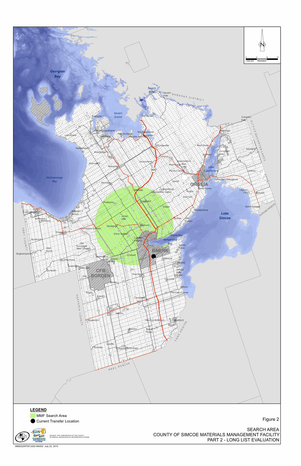
2.1 Search Area
The first step in the siting process was to define the search area within which the MMF will be located. One of the key functions of a transfer facility is to act as consolidation point: collection vehicles from throughout the County will transport materials to the MMF so that they can be consolidated and loaded into larger transfer trailers and hauled to their end destination(s). As such, these facilities are highly dependent on transportation networks. Siting a transfer facility close to where the materials originate (often referred to as the 'waste centroid' or the "centre of waste generation") can significantly reduce costs related to hauling. Using a waste centroid approach to define the search area will serve to optimize the facility location.
The search area for the MMF was defined using the waste centroid approach described below.
• All data required for mapping was sourced from the County's Graphical Information Systems (GIS) Department, and manipulated using ArcGIS.
• Population was used as a proxy for waste generation, which is typically based on a per capita rate.
• The entire County was subdivided into a series of 'parcels' based on municipal boundaries.
• A single waste generation node was created within each parcel, weighted in terms of size and location based on population density.
• The waste centroid was determined by combining the individual waste generation nodes into a single point, again weighted in terms of size and location based on population density.
• A radius of 15 kilometres (km) was used to expand the singular waste centroid point into a two dimensional area. A radius of 15 km was chosen based on a variety of reasons, including:
- Transportation efficiencies – maximizing the search area to include a reasonable list of candidate sites, while minimizing the distance from the centroid as transportation costs increase with distance.
- The radius encompasses a relatively large area within which a sufficient number of County-owned and privately-owned sites can be identified.
- The area encompasses major transportation routes, including both north-south and east-west corridors.
- The area encompasses properties with consistent zoning (e.g., industrial) for a MMF.
- The private transfer facility (i.e., Progressive Waste Solutions in Barrie) currently used by the County is located within the 15 km radius. This is used as an indicator only, in that a privately-owned facility would also consider similar siting factors such as minimizing haul distances.
• The outer boundary was adjusted to exclude lands within the City of Barrie.
It should be noted that the waste centroid calculations include data from the separated cities of Barrie and Orillia. In June 20114, County staff submitted an application to the CIF to secure funding
4 County of Simcoe Staff Report, Item Number CS 11-103, Recyclables Transfer Facilities Funding Application
GHD | County of Simcoe – Materials Management Facility – Part 2 – Long List Evaluation | 086822 (5) | 5
for the construction of a MMF. Considering best practices, CIF noted that funding would be contingent on the potential for the facility to be jointly utilized by other local municipal jurisdictions on a cost recovery basis.
A map outlining the extents of the search area is presented in Figure 2.
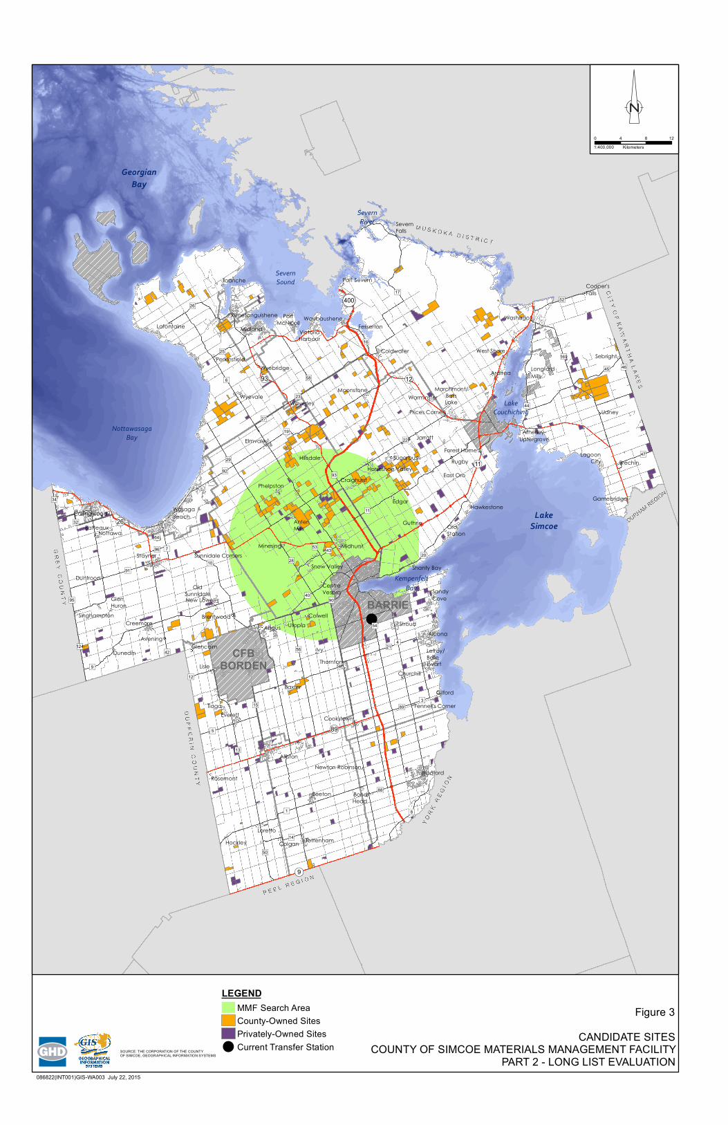
2.2 Candidate Sites
A comprehensive list of candidate sites was developed from sites located within the defined search area. Most parcels of land in Ontario are assigned a unique Property Identification Number (PIN), which is associated with information such as: legal ownership, geographic location (municipal street address and/or lot and concession numbers), size, and boundaries. Some properties are comprised of multiple PINs; however, for this evaluation each PIN was considered to be an individual, with certain exemptions noted in Section 2.3.2.
PINs are maintained through the Province of Ontario Land Registration Information System (POLARIS) and associated mapping database, which is managed by Teranet Enterprises Inc., under an agreement with the Ontario Ministry of Natural Resources (MNR) – Land Information Ontario, and the Municipal Property Assessment Corporation (MPAC). Some municipalities (including the County) also maintain their own internal databases using GIS based on similar data.
As was outlined in Part 1, the list of candidate sites was compiled from two main sources: County-owned sites and privately-owned sites from willing vendors that may be suitable to host the MMF. Including both sources in the site search ensures a broad approach that increases the likelihood that an ideal site can be identified.
2.2.1 County-Owned Sites
A list of County-owned sites for consideration was provided by the County, based on an inventory of existing sites from the Solid Waste Management and Forestry Departments. PINs for each site were also provided and verified by the County's Procurement, Fleet and Property (PF&P) Department.
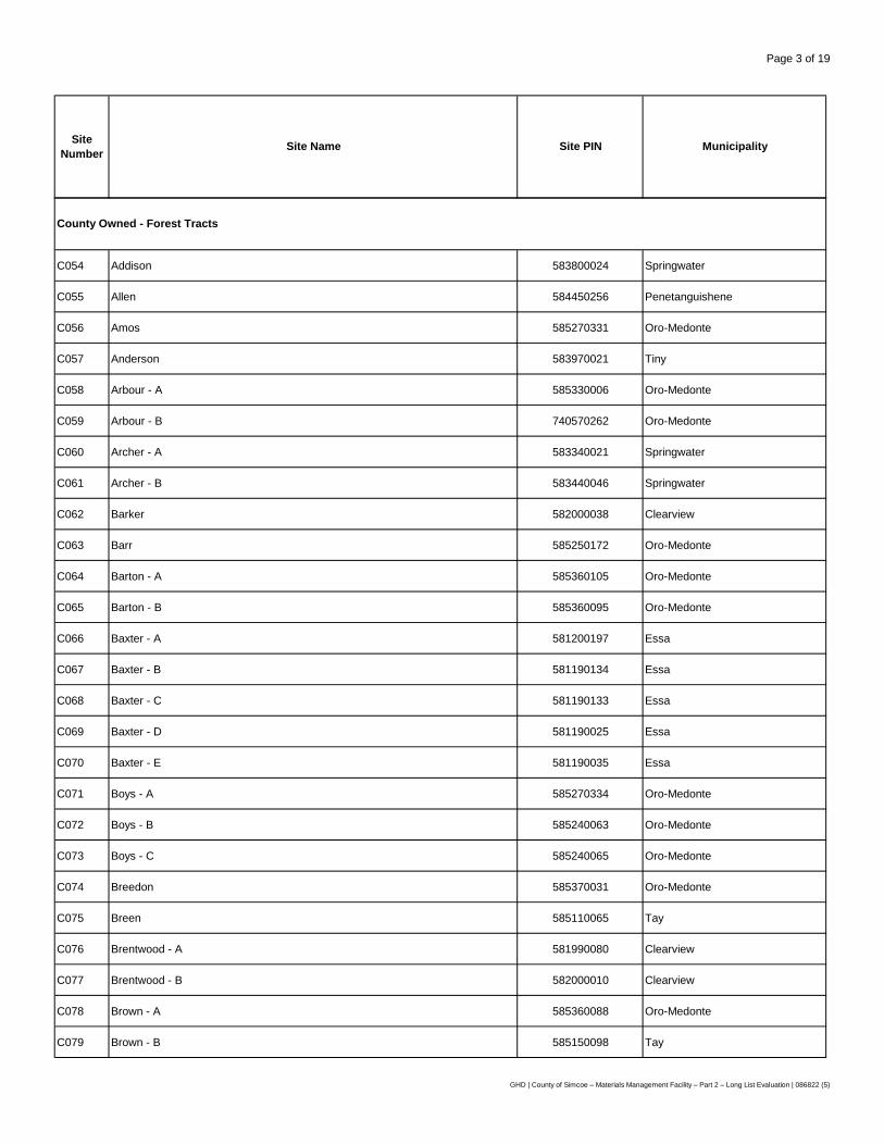
The complete list of County-owned sites comprised both open and closed waste facilities (i.e., landfill sites and transfer stations), as well as County forest tracts.
2.2.2 Privately-Owned Sites
A list of privately-owned sites for consideration in siting the MMF was developed by the County's PF&P Department from two sources: willing vendor sites identified through a Request for Expressions of Interest (RFEI) process, and through a search of the Multiple Listing Service (MLS) of the Canadian Real Estate Association (CREA).
RFEI Process
Land owners in the County that were interested in selling their property for the MMF were invited to submit a Letter of Interest through a RFEI. RFEI documents were posted on April 22, 2015 on the project webpage and on the County's online procurement site, biddingo.com5. Advertisements were also placed in newspapers County-wide on April 30, May 7, and May 14, and information was
5 County of Simcoe Request for Expression of Interest 2015-051, Properties for Proposed Materials Management
GHD | County of Simcoe – Materials Management Facility – Part 2 – Long List Evaluation | 086822 (5) | 6
provided in the May 2015 "Managing Your Waste" newsletter sent to all County residents. The project contact list was notified of this opportunity directly.
The RFEI outlined minimum technical requirements such as site size and other key considerations such as the avoidance of sensitive environmental features. The RFEI also identified various submission requirements including the name(s) of the registered owner(s) and a full legal description of the site. The RFEI process was open for a period of one month, with interested parties required to submit a letter of interest by May 22, 2015.
MLS Search
Additional privately-owned sites were identified through a search of the CREA's MLS database. To assist the County's PF&P Department, the County retained a registered broker from CBRE Limited's Land Services Group via a Request for Pre-Qualification (RFPQ) for provision of real estate brokerage services. The MLS search of available properties included both residential and commercial listings that met the same minimum technical requirements as outlined for the RFEI process.
2.2.3 Final List of Candidate Sites
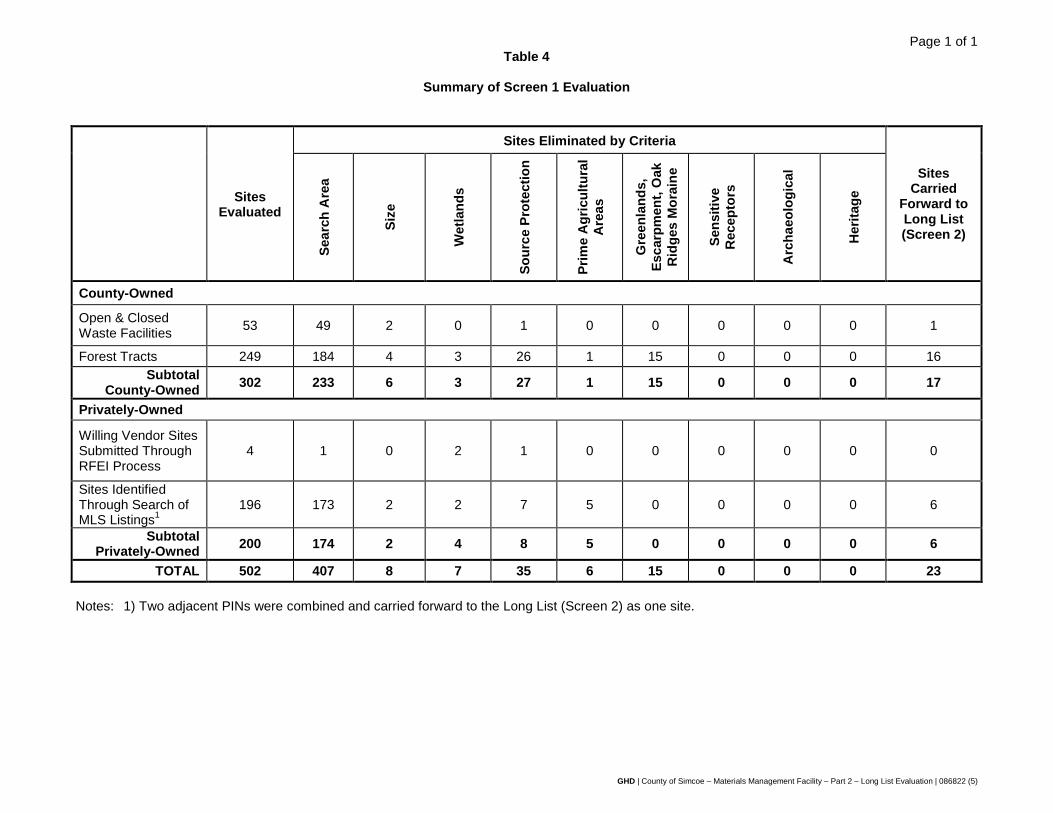
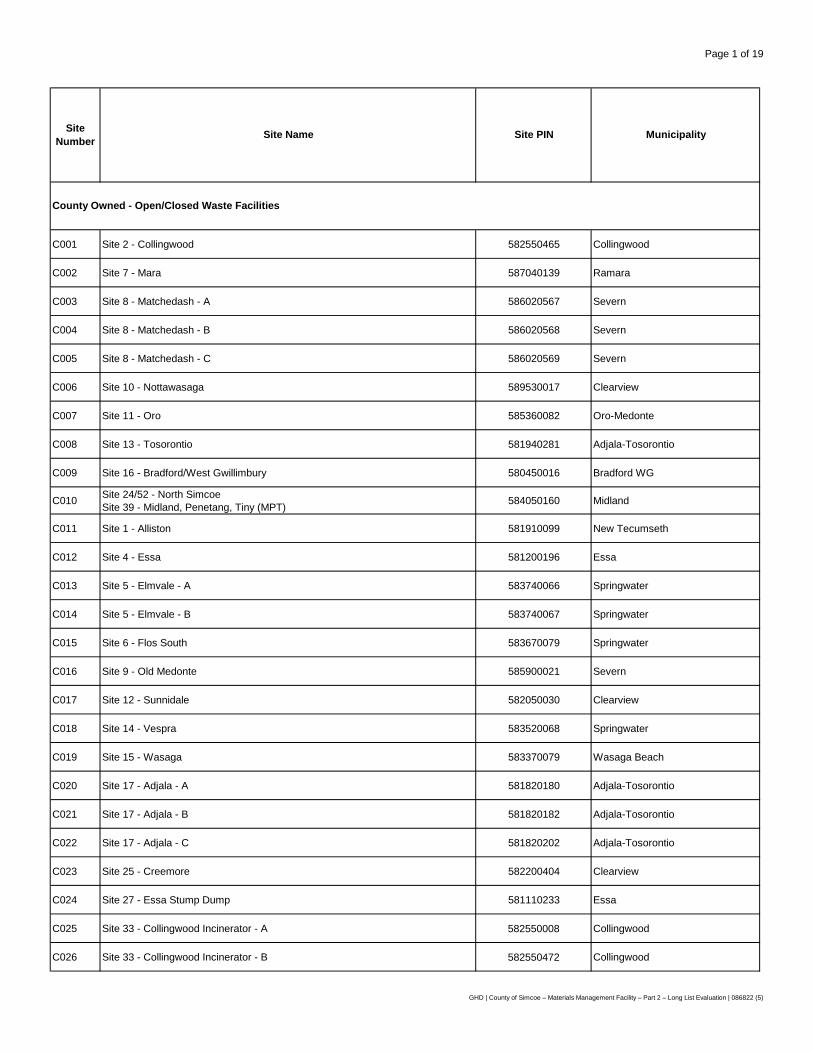
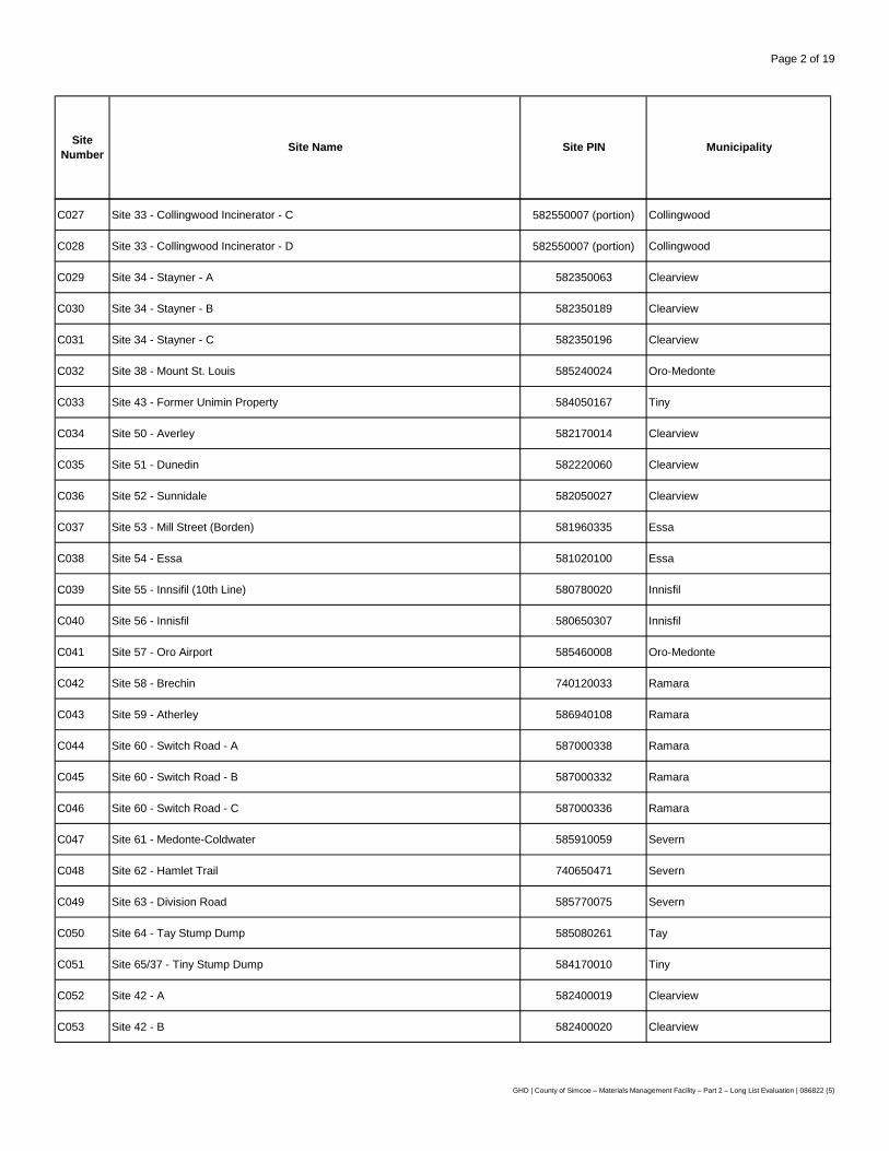
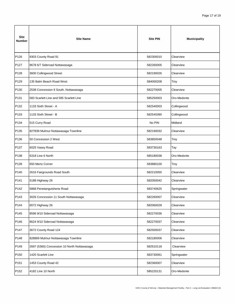
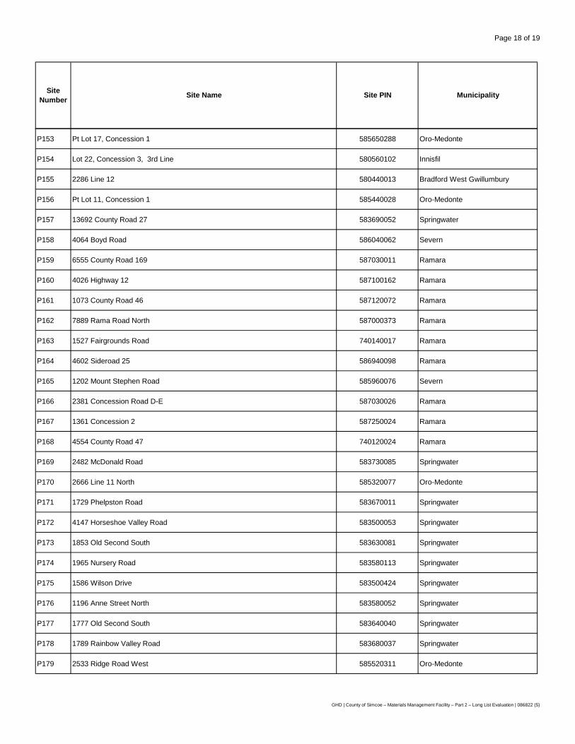
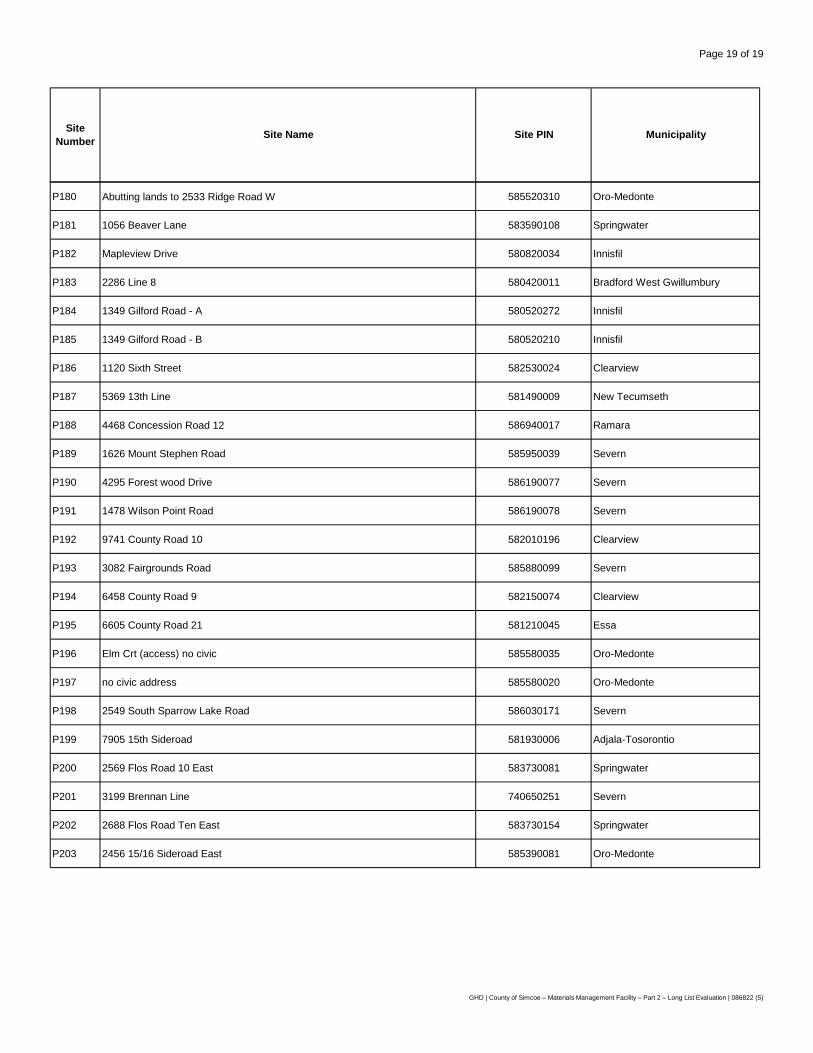
Based on the search details outlined above, a total of 505 sites were identified for consideration in siting the MMF. Table 1 provides a breakdown of the number of sites in each category.
All of the County-owned sites under consideration were evaluated, whereas only 4 of the willing vendor sites submitted through the RFEI process met the requirements for the MMF: one site was submitted only under the OPF project, while two of the sites did not meet the terms outlined within the RFEI. As a result, the final list of candidate sites evaluated for the MMF includes 302 County- owned sites, and 200 privately-owned sites, for a total of 502.
A map showing the locations of all candidate sites is provided as Figure 3. In addition, a complete listing of the sites has been provided in Appendix B. Each site was assigned a unique identification number for ease of reference in further evaluations and reports. County-owned sites were assigned the prefix 'C' (e.g., C019) while privately-owned sites were assigned the prefix 'P' (e.g., P152).
Further information on the list of candidate sites and an update on the siting process were outlined in a Staff report presented to the Committee of the Whole on June 23, 20156.
2.3 Evaluation Criteria
Part 1 of this undertaking established the evaluation criteria, which was vetted by the public and approved by County Council. A number of complimentary methodologies that utilize criteria as part of their evaluation process were also reviewed during Part 1. For example, while the proposed undertaking is not subject to the Ontario Environmental Assessment Act (OEAA), evaluation criteria
utilized for projects under the OEAA were reviewed and added, where appropriate. As the OEAA contains a broad definition of the "environment", we believe it is appropriate for use on the MMF project. The OEAA suggests criteria that would fall under the natural, social, economic, cultural, and built (technical) environments and as such, lends itself to the proposed undertaking. Further, a
6 County of Simcoe Staff Report, Item Number CCW 15-229 – Solid Waste Management Infrastructure Projects –
Siting Process Update http://docs.simcoe.ca/ws_cos/idcplg?IdcService=GET_FILE&RevisionSelectionMethod=LatestReleased&dDocName=rsc481496
GHD | County of Simcoe – Materials Management Facility – Part 2 – Long List Evaluation | 086822 (5) | 7
review of previous siting projects that GHD was involved in was also conducted to determine which criteria were utilized for siting similar facilities. In addition, GHD considered the evaluation criteria presented in various technical guidance documents applicable to the proposed undertaking (i.e., guidelines for siting/establishing waste transfer stations from other provinces including Nova Scotia7 and Newfoundland & Labrador8, and Waste Transfer Stations: A Manual for Decision-Making from the United States Environmental Protection Agency).
Based on the above, best practices from previous experience siting waste management facilities, and input from stakeholders (i.e., members of the public), a comprehensive list of evaluation criteria was developed during Part 1. This list was subsequently approved by County Council. Each criterion was grouped into a common component (similar to those described above under the OEAA), and assigned a series of indicators that were utilized in the evaluation. It should be noted that the components selected mirror those from the OEAA and as such, reflects each aspect of the broadly defined "environment" under this provincial legislation. One further component, "legal", was added to ensure that specific criteria that might not be captured under an "environmental" component were included that may influence the selection of a particular site (i.e., land acquisition risk and liability).
Part 1 established the evaluation criteria in a series of 3 separate screens. This report, Part 2, utilized the evaluation criteria listed under Screens 1 and 2 and applied these criteria/indicators to the list of candidate sites and the long list of sites, respectively, ultimately arriving at a short list of sites. These sites will be subject to further evaluation under Screen 3 (Part 3). Sites that satisfy the evaluation criteria at each screen are deemed to be the most feasible, and will be carried forward for further evaluation in the subsequent stage.
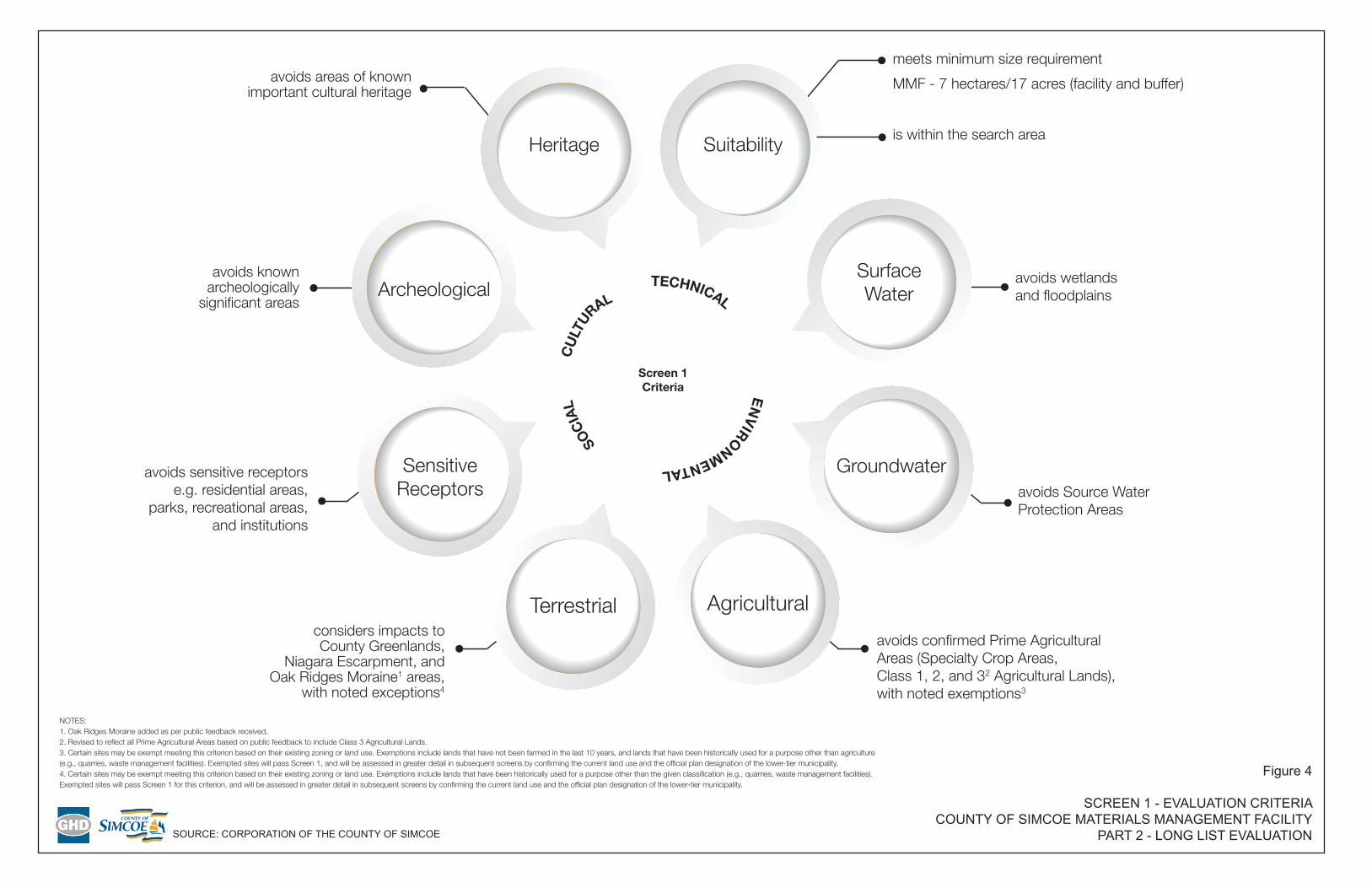
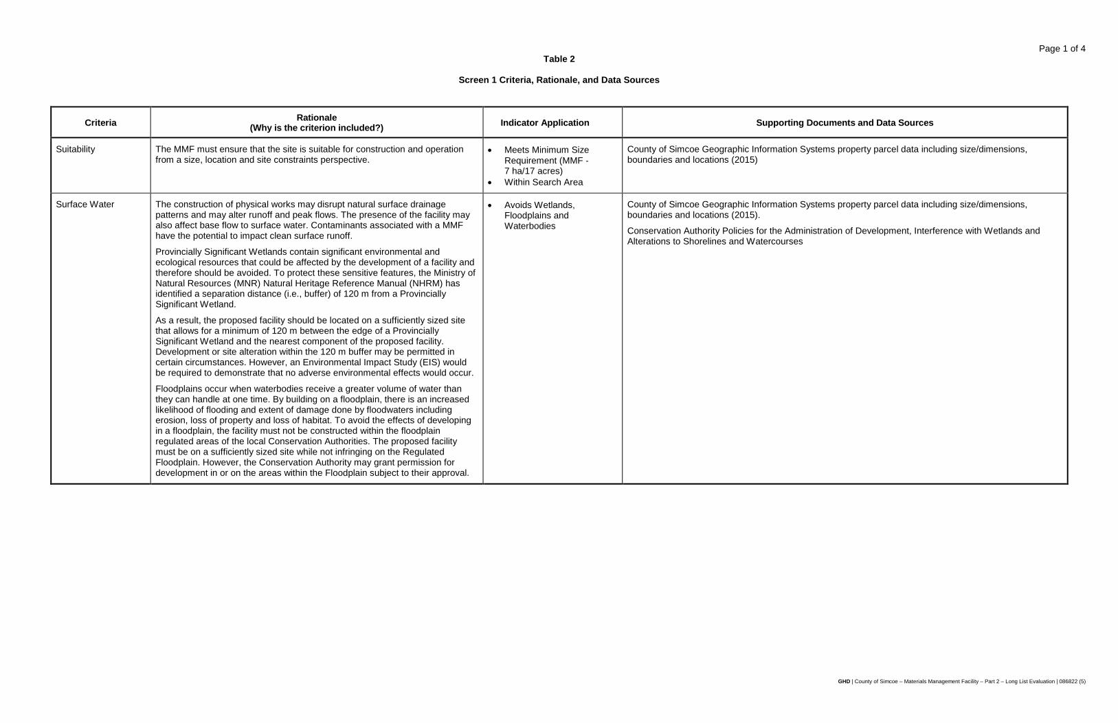
From a process perspective, Screen 1 (Figure 4) consisted of a number of exclusionary criteria which reduced the large number of sites down to a manageable long list for further evaluation. These criteria were considered "must pass", which a given site must satisfy in order to be carried forward for further evaluation. The exclusionary criteria are based largely on the technical requirements of a MMF facility that meet the program needs set out by the County and provide a minimum threshold in order for a site to be considered. The final list of exclusionary criteria, Screen 1, was developed by GHD with input from the County, as well as the public. Further information on the evaluation results and a summary table showing the sites that met all of the exclusionary criteria, and therefore were carried forward to the long list of sites, is provided in Section 3 of this report.
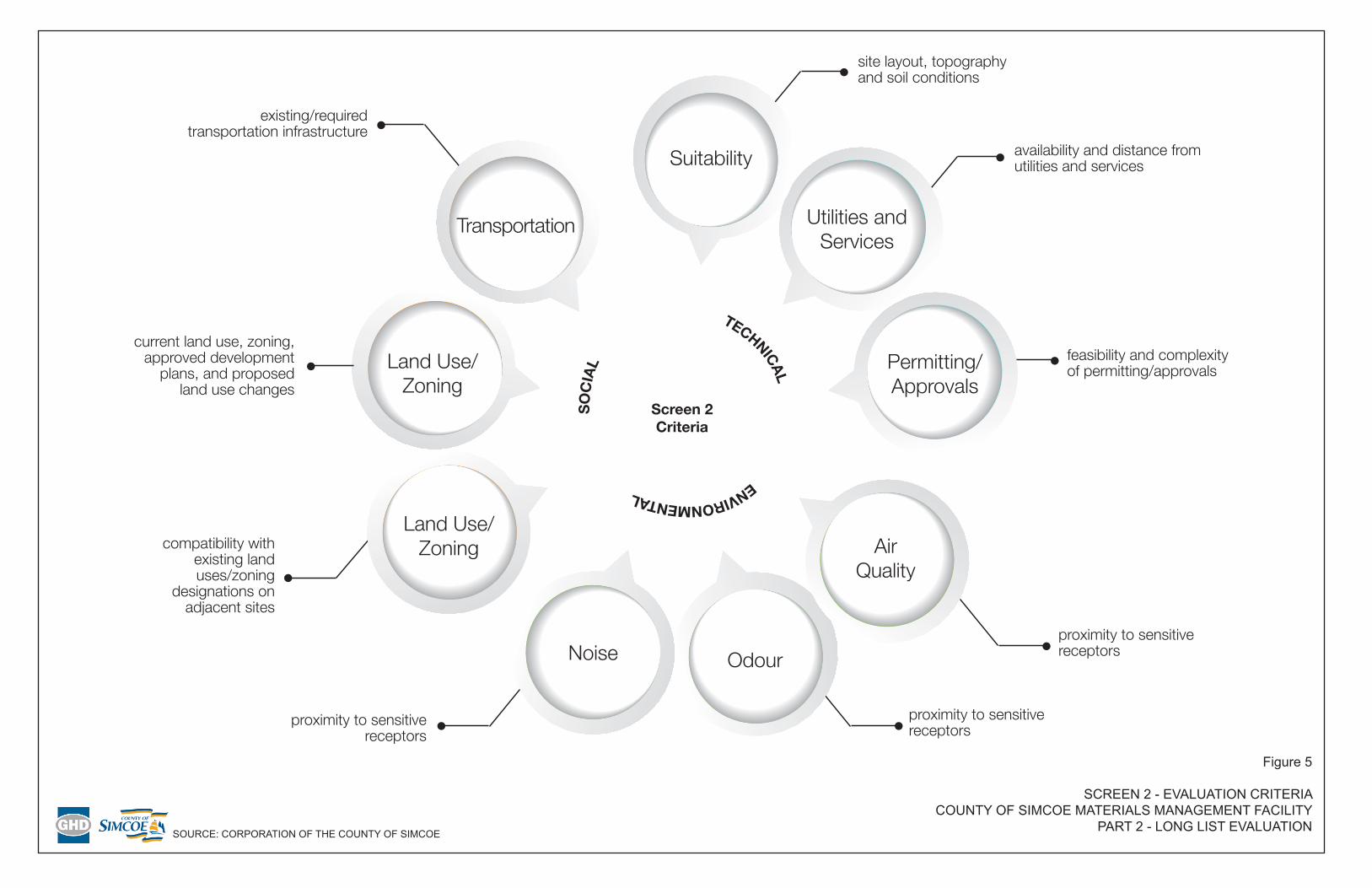
Screen 2 (Figure 5) builds on the exclusionary criteria and focuses on key criteria that can be used to differentiate the sites, including additional avoidance criteria (i.e., from sensitive receptors due to odour, noise, etc.) and site suitability criteria. This ensures that only the best candidate sites are carried forward to the short list for comparative evaluation. Screen 2 criteria were applied to the long list of sites and added an additional level of rigor to those criteria and indicators utilized during Screen 1. For example, separation distances to sensitive receptors (as defined in Appendix A) were reviewed at a high-level to determine which sites should be removed given their location relative to a sensitive receptor. Further information on the evaluation results and a summary table showing the short-listed sites is provided in Section 3 of this report. The short-listed sites will be carried forward for further detailed comparative evaluation as part of Screen 3 (Part 3).
7 Guidelines for the Siting and Operation of Waste Transfer Stations, Nova Scotia Environment and Labour, 2006 8 Environmental Standards for Municipal Solid Waste Transfer Stations / Local Waste Management Facilities,
Government of Newfoundland and Labrador, 2010
GHD | County of Simcoe – Materials Management Facility – Part 2 – Long List Evaluation | 086822 (5) | 8
It should be noted that the approved criteria listed under Screen 1 were modified based on input received from the public at the second public information session. Through input from the public, the following criteria were modified (with the change underlined and italicized):
• Environmental – Agriculture: Prime Agricultural Areas (Specialty Crop Areas, Class 1, 2 and 3 Agricultural Lands).
• Environmental – Terrestrial: Oak Ridges Moraine Land Use.
Further clarification was also provided on these criteria in terms of exemptions during the Screen 1 evaluation. While these criteria are guided by the intent of the given land use designation, there are certain exemptions that need to be considered. These exemptions include sites that fall within the given land use area (e.g., Oak Ridges Moraine Land Use), but where the existing zoning is consistent with the proposed facility (e.g., waste disposal facilities, quarries). Sites that are exempt passed Screen 1, and were assessed in greater detail in subsequent screens by confirming the current land use and the Official Plan designation of the lower-tier municipality. Further details on exemptions and how they were applied during the evaluation process are described in Section 2.3.2 of this report.
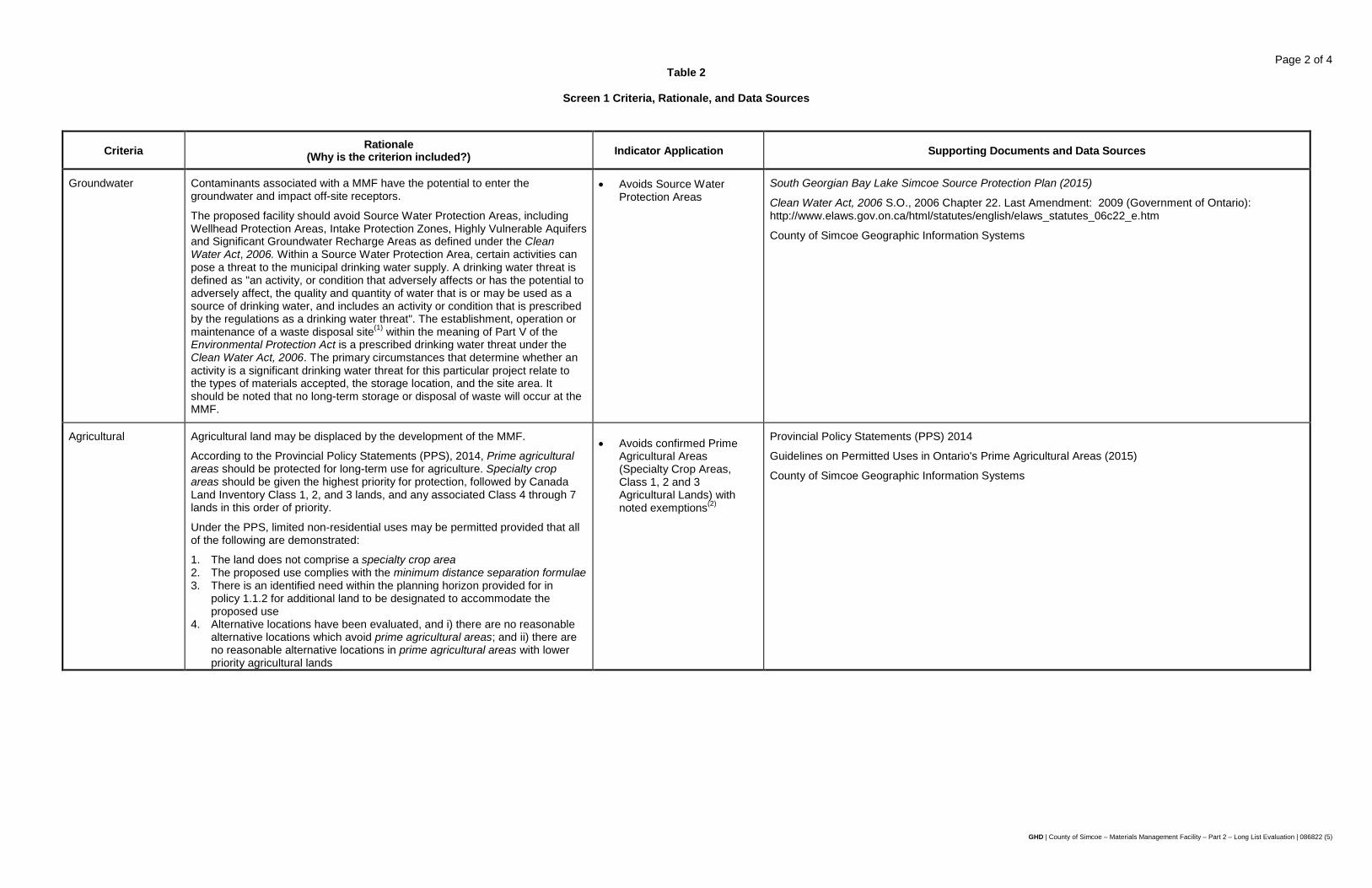
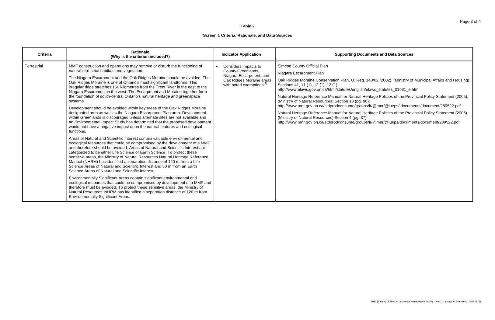
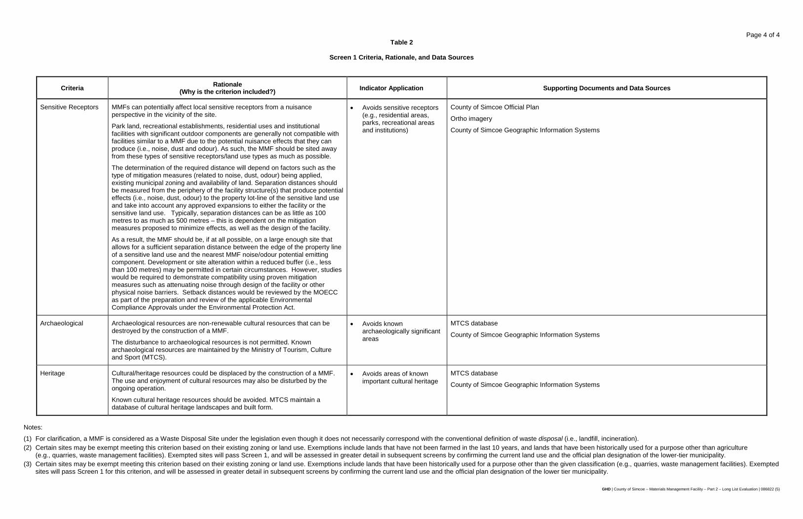
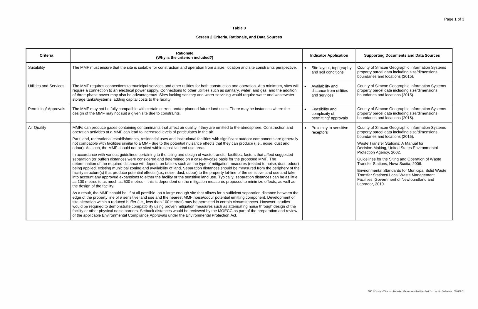
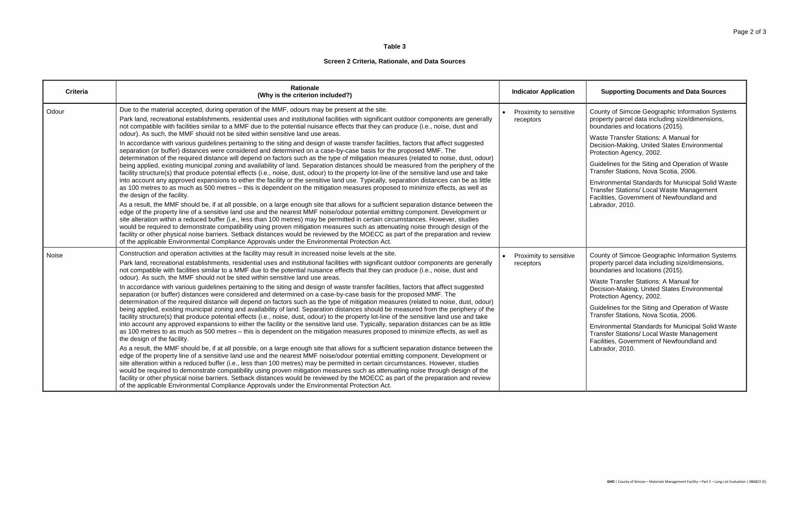
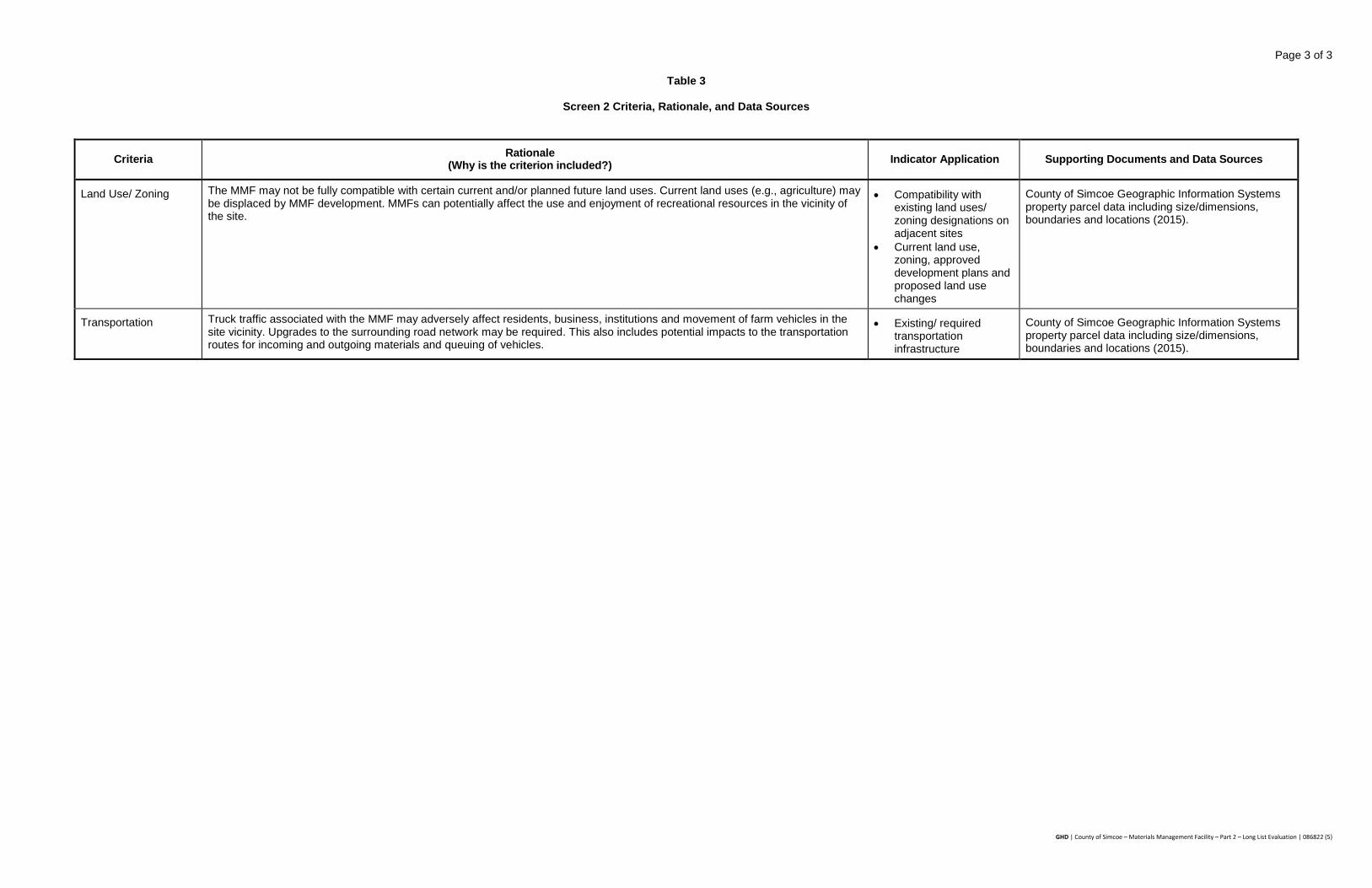
Tables 2 and 3 provide a description of the Screen 1 and 2 criteria/indicators, respectively, the rationale (i.e., why is the criterion included), as well as the data sources utilized.
2.3.1 Existing Conditions Mapping
Prior to applying the Screen 1 criteria to the list of candidate sites, available information on existing conditions and spatial data were collected and reviewed from a variety of sources. For the purposes of this report, the information collected was focused on the criteria and indicators included as part of Screen 1 and 2. The most current Geographic Information Systems (GIS) data from the County of Simcoe, Lake Simcoe Region Conservation Authority, Nottawasaga Conservation Authority, and the lower tier municipalities were obtained, including:
• Property parcel information including size/dimensions, boundaries, and locations.
• Transportation network.
• Waterbodies/watercourses.
• Location of existing Provincially Significant Wetlands (PSW).
• Environmentally Significant Areas (ESA).
• Location/extent of Areas of Natural and Scientific Interest (ANSI).
• Presence of significant wooded areas.
• County Greenlands.
• Oak Ridges Moraine.
• Regulated floodplains.
• Source Water Protection Areas, including: Wellhead Protection Areas, Intake Protection Zones, Vulnerable Aquifers, and Significant Groundwater Recharge Areas.
• Draft/approved development.
GHD | County of Simcoe – Materials Management Facility – Part 2 – Long List Evaluation | 086822 (5) | 9
In addition, existing guidance documents and regulatory requirements information was obtained, including:
• County of Simcoe Official Plan.
• Official Plans of lower-tier municipalities.
• Greenbelt Protection Plan.
• Provincial Policy Statement.
• Ministry of Natural Resources Natural Heritage Reference Manual.
• Oak Ridges Moraine Conservation Plan.
• Ontario Clean Water Act.
The available existing conditions information collected was incorporated into a GIS database and model to assist in the generation of potential sites for consideration under Screen 1 and Screen 2.
2.3.2 Exemptions
There were certain exemptions that were considered during the application of the evaluation criteria. Sites that were exempt from meeting a given criteria passed Screen 1, and were assessed in greater detail in Screen 2 as discussed below.
Agricultural
Although the Provincial Policy Statements (PPS), 2014, state that Prime Agricultural Areas should be protected for long term use for agriculture (which includes Specialty Crop Areas, followed by Class 1, 2 and 3 lands, in that order of importance), some sites affected by this criteria were carried forward through Screen 1 for further analysis. Screen 1 relies heavily on secondary source information, which in this particular case includes mapping from Canada Lands Inventory (CLI), which the County of Simcoe utilizes for their Official Plan mapping. The CLI mapping is a significant database of information, but does not necessarily reflect land use changes over the years. Further, the CLI mapping itself is based largely on secondary sources. Therefore, to be prudent, certain sites were carried forward to the long list of sites to ensure that the sites could be assessed further in subsequent screens to confirm the agricultural use(s) on-site. For example, some exemptions included lands that have not been farmed in the last 10 years, or lands that have been historically used for a purpose other than agriculture (e.g., quarries, waste management facilities). Therefore, some exempted sites passed Screen 1, and were assessed in greater detail in Screen 2 by confirming the current land use and the Official Plan designation of the lower-tier municipality.
Terrestrial and Surface Water
Within the Terrestrial criterion, there were a number of potential exemptions that should be noted. First, certain sites were exempt from meeting this Screen 1 criterion based on their existing zoning or land use. Exemptions included lands that have been historically used for a purpose other than the given classification (e.g., quarries, waste management facilities), but have been re-designated through a re-zoning or an Official Plan review. In addition, there were a number of sites that had a portion with a feature requiring a setback. However, a reduction to that setback may be permissible depending on the legislation. For example, the Ministry of Natural Resources Natural Heritage Reference Manual (NHRM) has identified a separation distance of 120 m from a Life Science Area of Natural and Scientific Interest (ANSI); however, development within the 120 m buffer may be
GHD | County of Simcoe – Materials Management Facility – Part 2 – Long List Evaluation | 086822 (5) | 10
permitted in certain circumstances, provided that an Environmental Impact Study (EIS) is completed and demonstrates that no adverse environmental effects would occur. The preparation of an EIS to reduce setbacks is common to the following Terrestrial and Surface Water constraints:
• Provincially Significant Wetlands (PSW)
• Environmentally Significant Areas (ESA)
• ANSIs
• Floodplains/Hazard Lands
Given that a number of the potential sites that are County-owned are forest tracts, or "Greenlands" under the County's Official Plan, an exemption was reviewed for this type of site. County-owned Greenlands sites that met the rest of the Screen 1 criteria were carried forward to Screen 2 in order to confirm the current land use and the Official Plan designation of the lower-tier municipality. Further, the County's Official Plan does allow for developments to re-designate lands in the Greenlands designation if an EIS is prepared and demonstrates:
i) That the subject lands do not contain natural features, or if they do, that the proposed development or site alteration will have no negative impacts on those natural features or their ecological functions or to natural features or their ecological functions on adjacent lands.
ii) That the lands are not required as a connection or ecological function to the natural heritage systems.
Therefore, some exempted sites passed Screen 1, and were assessed in greater detail in Screen 2 by confirming the current land use and the Official Plan designation of the lower-tier municipality.
Source Protection
In 2006, the provincial government made a commitment to the citizens of Ontario by passing the Clean Water Act, which aims to protect municipal drinking water in the province with a multi-barrier approach, starting with Source Protection. Within the County, the South Georgian Bay Lake Simcoe Source Protection Committee has prepared a Source Protection Plan, which outlines drinking water vulnerability as well as policy to address the potential threats to Source Water.
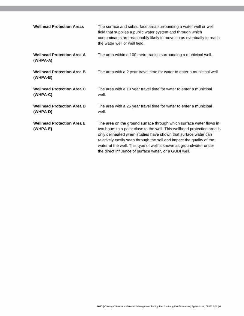
1. Wellhead Protection Areas (WHPA) – Wellhead protection areas are areas on the land around a municipal well, the size of which is determined by how quickly water travels underground to the well, measured in years. The WHPA ranges from WHPA-A to WHPA-D, which represents a travel time between 0-25 years.
2. Intake Protection Zones (IPZ) – Intake protection zones are the area on the water and land surrounding a municipal surface water intake. The size of each zone is determined by how quickly water flows to the intake, in hours.
3. Highly Vulnerable Aquifers (HVA) – An aquifer is an area underground that is highly saturated with water, enough so to be drawn for human use. A highly vulnerable aquifer is one that is particularly susceptible to contamination because of either its location near the ground's surface or because of the type of materials found in the ground around it (for instance, clay versus sand versus fractured rock).
GHD | County of Simcoe – Materials Management Facility – Part 2 – Long List Evaluation | 086822 (5) | 11
4. Significant Groundwater Recharge Areas (SGRA) – These are areas on the landscape that are characterized by porous soils, such as sand or gravel that allow the water to seep readily into the ground and flow to an aquifer. A recharge area is considered significant when it helps maintain the water level in an aquifer that supplies a community with drinking water.
As part of the Source Protection Plan, the County is in the process of adopting the following policy:
The following future uses and activities are prohibited in accordance with Section 57 and Section 59 of the Clean Water Act, where they are or would be a significant threat to drinking water as determined by a Risk Management Official, or another professional duly qualified through the Clean Water Act:
1. Any waste disposal sites, including transfer sites, within the meaning of Part V of the Environmental Protection Act (excluding storage of wastes described in clauses (p), (q), (r), (s), (t), or (u) of the definition of hazardous waste (O. Reg. 347) and storage of hazardous or liquid industrial waste).
Therefore, if a Waste Disposal Site is determined to be a significant threat to drinking water (i.e., within a WHPA), then the proposed use would be prohibited in that particular location. For clarification, a MMF is considered as a Waste Disposal Site under the legislation even though it does not necessarily correspond with the conventional definition of waste disposal (i.e., landfill, incineration), and there is no long-term storage or processing of waste. The definition of a Waste Disposal Site under Part V of the Environmental Protection Act means:
a) Any land upon, into, in or through which, or building or structure in which, waste is deposited, disposed of, handled, stored, transferred, treated or processed.
b) Any operation carried out or machinery or equipment used in connection with the depositing, disposal, handling, storage, transfer, treatment or processing referred to in clause (a).
It should be noted that potential sites with a WHPA, IPZ or HVA constraint were removed from consideration for the MMF. With respect to the SGRA designation, the County's mapping delineates three separate areas – low, medium and high vulnerability SGRA. Sites that had a medium and high vulnerability SGRA were removed at Screen 1, while sites that had a low vulnerability SGRA were carried forward for further evaluation. The rationale behind this is as follows:
1) A MMF is categorized as a municipal Waste Disposal Site and would fall under a Drinking Water Threat that involves the establishment, operation or maintenance of a Waste Disposal Site.
2) In reviewing the Clean Water Act, Table 1 identifies a number of Drinking Water Threats with respect to the establishment, operation or maintenance of a Waste Disposal Site within the meaning of Part V of the Environmental Protection Act. However, all of the references to "Municipal Waste", only equate a threat to "land disposal" as defined in Section 1 of Regulation 347. "Land Disposal" means, with respect to a waste, the deposit or disposal of the waste upon, into, in or through land, including:
a) The deposit of the waste at a dump.
b) The landfilling of the waste.
c) The discharge of the waste into a geological formation by means of a well.
d) The landfarming of the waste, in the case of a petroleum refining waste.
GHD | County of Simcoe – Materials Management Facility – Part 2 – Long List Evaluation | 086822 (5) | 12
3) It is clear that based on the definition above that the proposed MMF does not involve land disposal, but the Source Protection Policies contained within the South Georgian Bay Lake Simcoe Source Protection Plan would still be under consideration.
4) The Source Protection Policies for waste disposal sites apply to sites that are a 'Significant Threat', with a vulnerability score of 8 to 10.
5) The sites within the SGRA have a vulnerability score of 6, which is a threat level of "low" (i.e., not a 'Significant Threat') and therefore the policies prohibiting a waste facility would not apply.
It is for these reasons that sites with a low vulnerability SGRA were carried forward. It should be noted that further analysis and confirmation will be undertaken at Screen 3 with respect to Threats and Risk Levels under the Source Protection Plan. Further consultation with respect to Source Protection will take place with key stakeholders as the site selection and evaluation process continues. Stakeholders include Source Protection Authority and Committee representatives, Conservation Authorities, local municipalities and First Nations.
Size
Several properties, especially larger County forest tracts, were comprised of multiple sites (i.e., PINs). With respect to site size, individual sites were assessed in conjunction with adjacent sites if they could be combined to meet the minimum size requirement of 7 ha. For example, adjacent sites with respective areas of 5 ha and 3 ha would not meet the minimum size requirement if assessed individually; however, since the total area of both sites exceeds the minimum size requirement, these sites would be combined and carried forward as a single site. In cases where it was not advantageous to combine adjacent sites to meet the minimum size requirement (e.g., adjacent sites with respective areas of 1 ha and 43 ha, or adjacent sites with respective areas of 31 ha and 84 ha), then these sites were evaluated on an individual basis.
GHD | County of Simcoe – Materials Management Facility – Part 2 – Long List Evaluation | 086822 (5) | 13
3. Evaluation & Results
3.1 Screen 1 Evaluation
In order to assess the candidate sites against the Screen 1 criteria, GIS layers (as identified in Section 2.3.1) were compiled and mapped in conjunction with the site locations and boundaries as defined by their PINs. Each site was assessed in detail to determine which criteria, if any, would exclude it from being considered for the long list of sites. To assist in the analysis, ortho-imagery from Google Earth was also used to gain a better understanding of the local site conditions and the regional context.
If a site was affected by multiple criteria, it was eliminated based on the criterion that had the most significant impact or would be the most difficult to overcome when considering the development of the MMF (e.g., constructing the facility in a wetland, or a wellhead protection area).
An ideal site carried forward in the evaluation process was one that was completely clear of potential conflicts with Screen 1 criteria. However, it should be noted that most sites contained at least some areas that were affected by Screen 1 criteria. In these cases, the sites passed Screen 1 if the remaining area of the site with no potential conflicts was large enough to meet the minimum size requirement of 7 ha. This analysis was only required in a fraction of the sites, as most were affected by at least one criteria, or the remaining area of the site free from conflicts was too small.
Final assessment considered the exemptions noted in Section 2.3.2. If the potential conflicts could be rationalized in a way that would still allow for the development of the MMF, then the site was carried forward to Screen 2 for further evaluation. This did not necessarily signify that the criteria in question would not ultimately rule the site out, but merely that it should be exposed to further scrutiny during subsequent analyses.
Results of the Screen 1 evaluation are summarized in Table 4, detailing how many sites were eliminated under each criterion. As outlined, a total of 23 sites were carried forward to the long list evaluation in Screen 2.
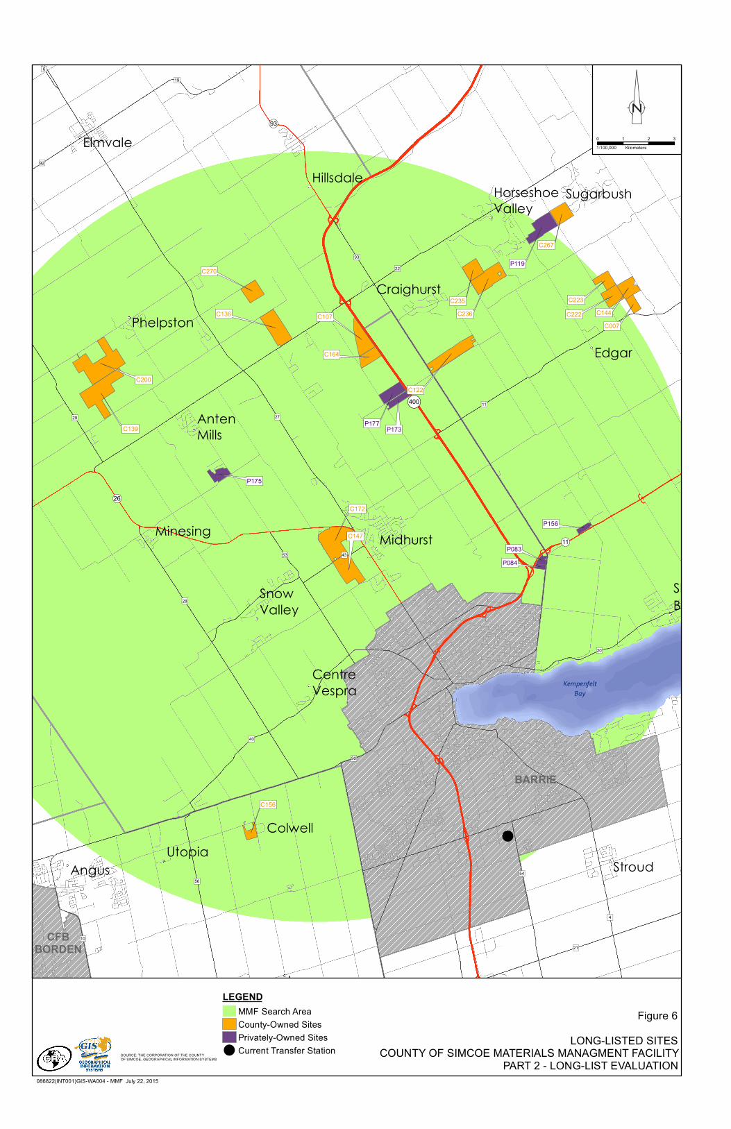
A map showing the locations of all of the long-listed sites is provided as Figure 6.
3.2 Screen 2 Evaluation
The previously-developed GIS database and model were updated to include additional existing conditions information to reflect Screen 2 criteria and indicators. Further to this, cursory visual inspections were carried out on May 15, 2015 at several long-listed sites to augment the secondary source data presented in Screen 1. The following information was updated in the GIS database when reviewing the long list of sites:
• Topography and soil conditions.
• Utilities and services.
• Location(s) of sensitive receptors (to determine distance from a potential site).
• Land uses of lower-tier municipalities (Official Plan and Zoning).
• Transportation networks.
GHD | County of Simcoe – Materials Management Facility – Part 2 – Long List Evaluation | 086822 (5) | 14
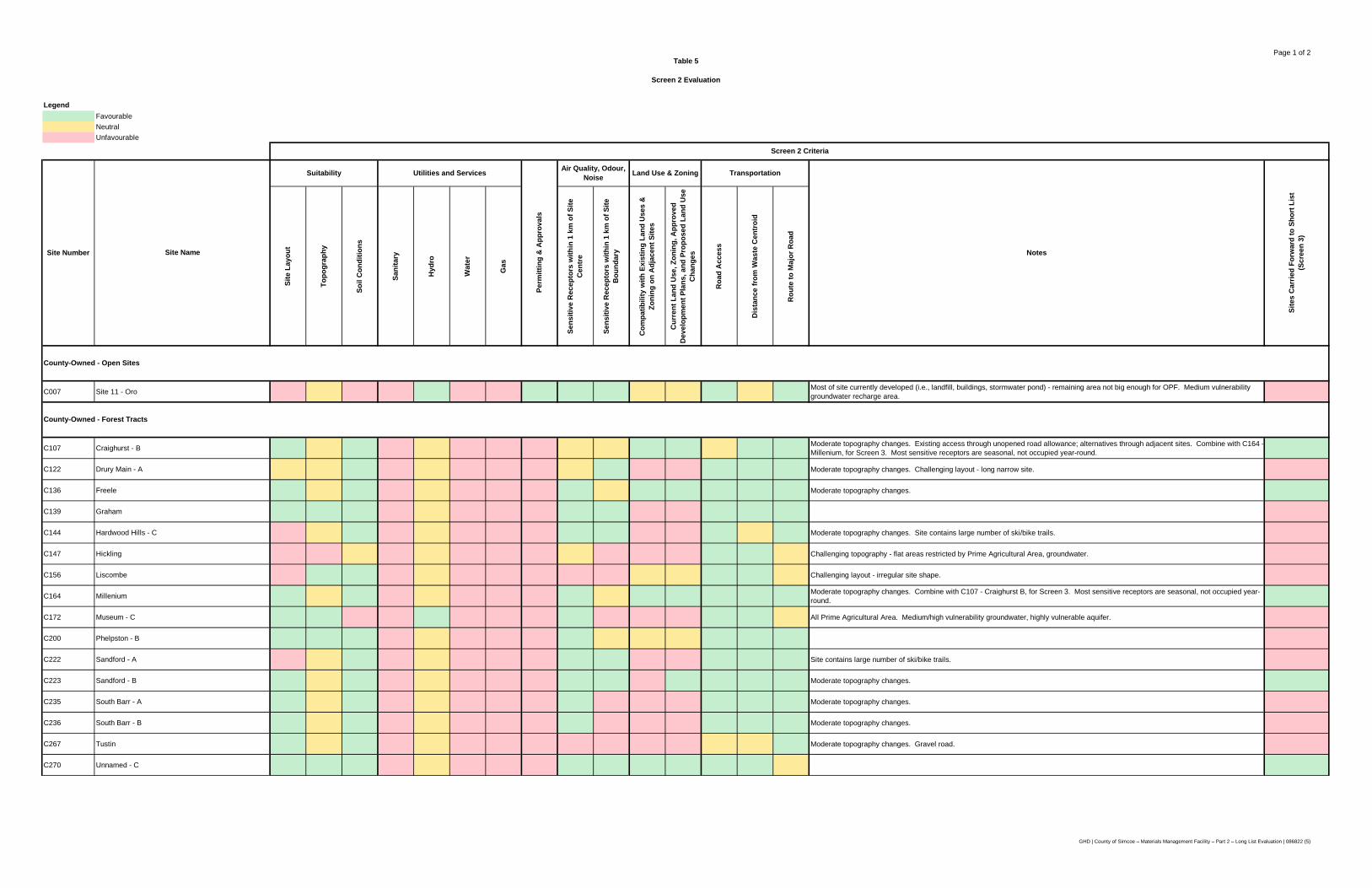
The Screen 2 criteria were applied to each of the long list of 23 potential MMF sites via the updated GIS model. As the Screen 2 criteria build on the exclusionary criteria in Screen 1, a critical review of each site was undertaken in relation to these criteria. Each criterion was assigned either a favourable, neutral or unfavourable rating for each site. Accordingly, a potential MMF site with a greater number of favourable ratings had more advantages than an alternative MMF site with more unfavourable ratings. As such, a site that received more favourable ratings (i.e., greater number of advantages) was considered to be preferred over another site which received fewer favourable ratings.
Details of the Screen 2 evaluation for each long-listed site are presented in Table 5. Overall results of the evaluation are summarized in Table 6, and are discussed below with respect to each component.
Technical
Screen 2 criteria/indicators within the technical component are as follows:
• Suitability – site layout, topography and soil conditions
- Sites with an irregular shape or existing infrastructure may limit layout configurations.
- Sites that are relatively flat may reduce design and construction requirements.
- Sites with poor soil conditions (e.g., high moisture content, low bearing capacity) may increase design considerations.
• Utilities and Services – availability and distance from utilities and services
- At a minimum, sites will require a connection to an electrical power supply. Connections to other utilities such as sanitary, water, and gas, and the addition of three-phase power may also be advantageous. Sites lacking sanitary and water servicing would require water and wastewater storage tanks/systems, adding capital costs to the facility
• Permitting/Approvals – feasibility and complexity of permitting/approvals
- In terms of the required permits and approvals (i.e., Environmental Compliance Approval (ECA), Official Plan Amendment, Zoning By-Law Amendment, Site Plan Approval), the facility may not be fully compatible with certain current and/or planned future land uses. For example, the Official Plan and/or Zoning By-Law may identify abutting or adjacent properties to a potential OPF site that are designated as future residential, future recreational or other type of "Sensitive Receptor" (as defined in Appendix A)
Considering these factors from a holistic perspective, a site is preferred when it is comparatively more suitable than the other sites for construction and operation of a MMF because it typically has a combination of relatively larger site size and suitable area, is located within existing connections or close proximity to utilities and services, and any additional permitting/approvals may be readily obtained for the proposed development.
Environmental
Screen 2 criteria/indicators within the environmental component are as follows:
• Air Quality – proximity to sensitive receptors.
• Odour – proximity to sensitive receptors.
GHD | County of Simcoe – Materials Management Facility – Part 2 – Long List Evaluation | 086822 (5) | 15
• Noise – proximity to sensitive receptors.
From an Air Quality, Odour and Noise perspective, the MMF should be located on a site that maximizes the separation distance to sensitive receptors (as outlined in Appendix A) and limits the number of sensitive receptors in proximity to the MMF site.
Park land, recreational establishments, residential uses and institutional facilities with significant outdoor components are generally not compatible with facilities similar to a MMF due to the potential nuisance effects that they can produce (i.e., noise, dust and odour). As such, the MMF should not be sited within close proximity to sensitive land use areas. The MMF should be situated on a sufficiently sized site that allows for an appropriate buffer between the property line of a sensitive receptor and the nearest MMF air quality/odour/noise potential emitting component.
Guideline D-49 specifies restrictions and controls on land use that the MOECC wishes to see implemented in the vicinity of landfills and dumps, and serves as a reasonable indicator of potential considerations for other types of waste facilities such as a MMF. Guideline D-4 notes that the MOECC considers the most significant contaminant discharges and visual problems to be normally within 500 metres of the perimeter of a landfill fill area. Accordingly, the MOECC recommends that this distance be used as a study area for land use proposals.
Given that the layout and design of the MMF have not been defined at this point in the Study, a conservative approach was utilized to determine the proximity of sensitive receptors relative to potential sites. Distances to sensitive receptors were evaluated as follows:
• 1 kilometre from the centre of the site.
• 1 kilometre from the boundary of the site.
The approximate number of sensitive receptors within these distances was determined for each site by using ortho-imagery and counting visible features such as buildings, campgrounds, and parks. Sites that had the fewest sensitive receptors within these distances have the greatest potential to maximize buffer distances between the property line of a sensitive receptor and the MMF. Noting how conservative these distances are, especially in relation to a MMF, the estimates were further refined for each short-listed site to consider the number of sensitive receptors within 500 metres of the site boundary.
It should be noted that this analysis is solely based on proximity to and the number of sensitive receptors and does not include mitigation measures through design of a facility, other than locating the MMF on a large enough property to incorporate greater buffer distances on the potential site itself. The Screen 3 evaluation will consider the placement of the MMF on each site relative to sensitive receptors, factors such as the predominant wind direction, and mitigation measures such as screening berms.
Social
Screen 2 criteria/indicators within the social component are as follows:
• Land Use/Zoning – Current land use, zoning, approved development plans and proposed land use changes.
9 MOECC Guideline D-4 – Land Use On or Near Landfills and Dumps
The proposed MMF should be located on a site that is compatible with current and planned future land uses/designations (i.e., avoids future planned developments, schools, institutions, residential areas, recreational areas, etc.) as much as possible as outlined in the County's Official Plan, as well as the appropriate Official Plans of the lower tier municipalities.
Land uses on adjacent sites that are compatible with the proposed MMF include Rural, Agricultural, and Industrial designations, which offer compatibility from the perspective of minimal sensitive receptors/uses as well as increased buffer distances. Adjacent lands that are designated as rural residential, residential, private and public recreational and employment were deemed to be incompatible with a proposed MMF.
In terms of current land uses on a given site, only one of the long-listed sites currently have a land use designation that is appropriate for a proposed MMF – Site 11 – Oro. All of the other sites would require an amendment to the appropriate land use instruments to allow for a MMF.
Current land uses of long-listed sites not compatible with the MMF included the Oro Moraine, which includes Core, Corridor and Enhancement/Re-vegetation designations. These types of land uses are restrictive in terms of an appropriate use and/or the ability to re-designate/rezone for an MMF. In addition to the Oro Moraine, other non-compatible land uses included Environmental Protection Zones and uses such as Employment lands. Consequently, construction and operation of the proposed MMF on sites that would displace the intended future land use for adjacent lands were considered to be less preferred than other sites.
3.3 Short-Listed Sites
Five of the 23 long-listed MMF sites assessed through the application of Screen 2 criteria comprise the short list of sites. The five short-listed sites are:
• Site C164/C107 – County-Owned – Millenium/Craighurst Forest Tracts.
• Site C136 – County-Owned – Freele Forest Tract.
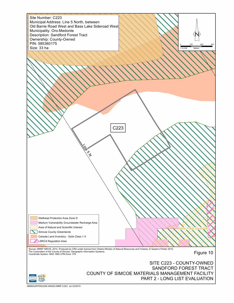
• Site C223 – County-Owned – Sandford Forest Tract.
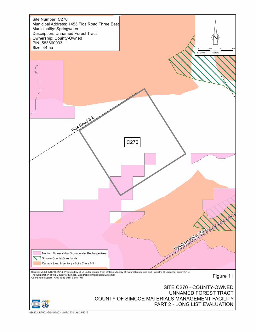
• Site C270 – County-Owned – Unnamed Forest Tract.
• Site P083/P084 – Privately-Owned – 540/528 Penetanguishene Road.
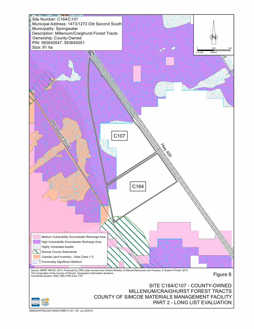
Additional details of these sites are summarized in Table 7. A map showing the locations of these sites is provided as Figure 7. Individual maps of each of the short-listed sites are provided as Figures 8 to 12.
These five sites are considered preferred over the other potential MMF sites as they had a comparatively higher number of favourable ratings (advantages), making them the most suitable sites for accommodating the proposed MMF. Specific details on these sites are provided below.
Site C164/C107 – County-Owned – Millenium/Craighurst Forest Tracts (Figure 8)
• Favourable/Neutral ratings in five of the seven Screen 2 criteria.
• Combined 91 ha in size.
GHD | County of Simcoe – Materials Management Facility – Part 2 – Long List Evaluation | 086822 (5) | 17
• Appropriate topography and soil conditions.
• Close proximity to utilities and services.
• Approximately 7 sensitive receptors within 500 metres of the site boundary.
• Adjacent to Rural, Agricultural and Open Space uses.
• Based on the surrounding land uses, the permitting and approvals are feasible.
• Approximately 7 km from the waste centroid, with direct road access and a favourable route to a major road.
• Lack of utilities and services on-site.
• Current designation and land use will require amendments to the land use instruments.
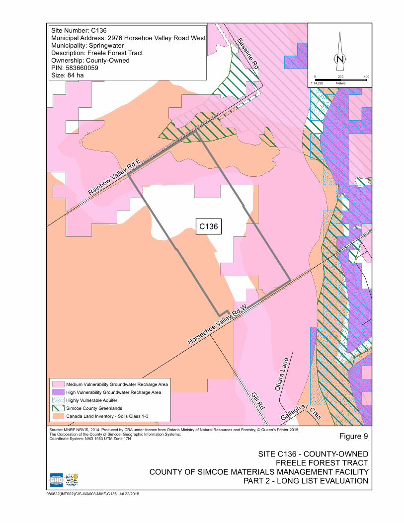
Site C136 – County-Owned – Freele Forest Tract (Figure 9)
• Favourable/Neutral ratings in five of the seven Screen 2 criteria.
• 84 ha in size.
• Appropriate topography and soil conditions.
• Approximately 8 sensitive receptors within 500 metres of the site boundary.
• Adjacent to Hazard lands, Rural, Agricultural uses.
• Based on the surrounding land uses, the permitting and approvals are feasible, although some setback requirements will be reviewed based on the on-site hazard lands.
• Approximately 8 km from the waste centroid, with direct road access and a favourable route to a major road.
• Lack of utilities and services on-site.
• Current designation and land use will require amendments to the land use instruments.
Site C223 – County-Owned – Sandford Forest Tract (Figure 10)
• Favourable/Neutral ratings in four of the seven Screen 2 criteria.
• 33 ha in size.
• Appropriate topography and soil conditions.
• Approximately 12 sensitive receptors within 500 metres of the site boundary.
• Adjacent to the Oro Moraine Core Area and Rehabilitation designation, an ANSI as well as Rural and Agricultural land uses.
• Based on the surrounding land uses, the permitting and approvals are feasible, although some setback requirements will be reviewed based on the on-site Oro Moraine Core Area.
• Approximately 14 km from the waste centroid, with direct road access and a favourable route to a major road.
• Lack of utilities and services on-site.
• Current designation and land use will require amendments to the land use instruments.
GHD | County of Simcoe – Materials Management Facility – Part 2 – Long List Evaluation | 086822 (5) | 18
Site C270 – County-Owned – Unnamed Forest Tract (Figure 11)
• Favourable/Neutral ratings in five of the seven Screen 2 criteria.
• 44 ha in size.
• Appropriate topography and soil conditions.
• Approximately 4 sensitive receptors within 500 metres of the site boundary.
• Adjacent to Natural Heritage, Rural and Agricultural land uses.
• Based on the surrounding land uses, the permitting and approvals are feasible.
• Approximately 10 km from the waste centroid, with direct road access and a favourable route to a major road.
• Lack of utilities and services on-site.
• Current designation and land use will require amendments to the land use instruments.
Site P083/P084 – Privately-Owned – 540/528 Penetanguishene Road (Figure 12)
• Favourable/Neutral ratings in five of the seven Screen 2 criteria.
• Combined 17 ha in size.
• Appropriate topography and soil conditions.
• Approximately 14 sensitive receptors within 500 metres of the site boundary.
• Adjacent to Hazard lands, Rural and Agricultural land uses.
• Based on the surrounding land uses, the permitting and approvals are feasible.
• Approximately 9 km from the waste centroid, with direct road access and a favourable route to a major road.
• Lack of utilities and services on-site.
• Current designation and land use will require amendments to the land use instruments.
GHD | County of Simcoe – Materials Management Facility – Part 2 – Long List Evaluation | 086822 (5) | 19
4. Public and Stakeholder Consultation
4.1 Community Engagement Committee
The Community Engagement Committee (CEC) met on June 22, 2015 to discuss general project updates with members, as well as the potential format(s) for the future public consultation sessions. Members of the CEC were in agreement that the future public consultation sessions to be held in the fall should be carried out with a presentation and a facilitated question and answer session, and
that the sessions should be held in multiple locations within proximity to the short-listed sites. Minutes of the CEC meeting are included in Appendix C.
A CEC meeting has been planned for early September, to allow members to review communication material for the planned public information sessions.
4.2 Private Sites Consultation
One privately-owned site has been carried forward to the short list. Privately-owned sites create unique challenges for a number of reasons, including:
Real estate markets are fluid and there is no guarantee that current sites will be available for purchase at the conclusion of this Study.
Additional costs will be incurred for land acquisition that may not have been budgeted.
The legal due�diligence of the purchase may add complexity and impact the project schedule.
Some information may be more difficult to obtain for private sites, hindering their evaluation.
Given the above challenges, it is recommended that the County initiate advance discussions with the property owner to secure the site prior to proceeding with further evaluation and public
consultation.
4.3 Public Consultation
Following direction from County Council during Part 1, GHD completed the work outlined in Part 2, which included screening all potential candidate sites to a long list of sites and subsequently further
evaluation and screening of the long list of sites to arrive at a short list of sites. A public consultation period is planned for the fall to present the results of the Screen 1 and Screen 2 analyses to the public and other stakeholders. A further description of the short-listed sites that will be carried
forward for Screen 3 and the comparative evaluation will also be presented. As recommended by the CEC, the format is expected to be a combination of a drop-in style open house, with a presentation followed by a facilitated question and answer session. This consultation round will be
held within proximity to the short-listed sites, with as many as 5 separate consultation events taking place to ensure each community receives direct information from the Project Team.
These consultation sessions allow the Project Team to engage directly with members of the public, specifically with respect to the Screen 1 and Screen 2 evaluation results. At the same time, these
sessions also allow the public to provide their input, thoughts and perspectives to the Project Team, creating an open, two-way dialogue. For example, the Project Team will present their evaluation results from the long list of sites to the short list, which is based on a number of Council endorsed
evaluation criteria. Members of the public will have the opportunity to provide site specific information from a historical and local perspective that may be important to include in the overall
GHD | County of Simcoe – Materials Management Facility – Part 2 – Long List Evaluation | 086822 (5) | 20
analysis and evaluation. This feedback from the public will be documented and included in Report 3 (Short List Evaluation).
In addition to providing input at the public meeting, the Project Team will also solicit feedback on the Screen 1 and 2 evaluation results through the project website, as well as comment sheets that will be available at the open houses. All of the comments submitted will be reviewed, documented and a response will be provided to the commenter. This feedback will also be documented and included in Part 3 (Short List Evaluation).
4.4 County Council Approval
Prior to moving forward with the comparative evaluation of the short-listed sites, County Council approval will be sought. The presentation of short-listed sites to Council is expected to take place in summer 2015 following the evaluation of both County-owned and privately-owned sites. In addition, we anticipate discussion on the forthcoming comparative evaluation process for the short-listed sites.
4.5 Next Steps
The overall Siting Report, which includes, methodology, screening, evaluation and selection, will be made up of three separate, but complimentary parts, as follows:
Part 1 – Planning – Siting Methodology and Evaluation Criteria
Part 2 – Long List Evaluation
Part 3 – Short List Evaluation
This report, Part 2, has documented the sites generated for evaluation, the establishment of a long list of potential sites, the screening of the long list of sites and the generation of a short list of sites. The results of the public consultation/feedback for the information presented in this report will be summarized in the Part 3 Report.
In addition, the Part 3 Report will also present the short-listed comparative evaluation results (utilizing Screen 3 evaluation criteria), effectively ranking the short-listed sites in order of preference and recommending a preferred site to County Council. It is anticipated that the preferred site will be presented in Report 3 to County Council in early 2016.
propose siting methodology
finalize siting methodology and evaluation criteria – report to County Council
identify potential County-owned sites and willing vendor privately-owned sites
Screen 1 - use exclusionary criteria to remove sites from further evaluation and develop long list of sites
Screen 2 - further screening of remaining sites using additional criteria to determine short list
Screen 3 - detailed comparative evaluation of short list
preferred site presented to County Council
Public Consultation
present short list of sites to County Council
technical studies to confirm
site conditions
Summer 2015
Early 2016
Early 2015
December2014
PLANNING - SITING METHODOLOGY
AND EVALUATION CRITERIA
Public Consultation
December 2, 2014
LONG LIST EVALUATION
SHORT LIST EVALUATION
Figure 1
SITING PROCESSCOUNTY OF SIMCOE MATERIALS MANAGEMENT FACILITY
PART 2 - LONG LIST EVALUATION SOURCE: CORPORATION OF THE COUNTY OF SIMCOE
!
!(89
!(11
!(93 !(12
!(9
!(26
!(400
")90
")96
")12
")4
")43
")54
")16
")5
")22
")40
")21
")64
")47
")44
")20
")19
")29
")34
")32
")42
")169
")8
")7
")23
")124
")11
")53
")88
")93
")15
")91
")9
")27
")25
")14
")3
")13
")56
")28
")50
")89
")1
")92
")52
")46
")26
")10
")17
")45
Thornton
Baxter
Ivy
ColwellUtopia
Angus
Alliston
Beeton
TottenhamColganHockley
Stroud
Churchill
Cookstown
NottawaBatteaux
Duntroon
GlenHuron
Creemore
New Lowell
Stayner
Avening
Brentwood
Dunedin
Singhampton
OldSunnidale
Sunnidale Corners
AntenMills
CentreVespra
Elmvale
Hillsdale
MidhurstMinesing
Snow Valley Shanty Bay
OroStation
Hawkestone
Guthrie
Forest Home
Edgar
Rugby
East OroCraighurst
Horseshoe ValleySugarbush
Jarratt
Prices Corners
WarminsterMoonstone
Victoria HarbourWaubaushenePort McNicoll
Waverley
Washago
Marchmont/BassLake
Coldwater
Toanche
Lafontaine
Perkinsfield
Wyevale
Wyebridge
WasagaBeach
Fesserton
Port Severn
SevernFalls
Bradford
BondHead
Newton Robinson
Collingwood
Midland
Penetanguishene
Alcona
Gilford
Cooper'sFalls
SebrightLongfordMills
Udney
Atherley- Uptergrove
Brechin
Gamebridge
Lefroy/BelleEwart
West Shore
Ardtrea
SandyCove
LagoonCity
Phelpston
EverettTioga
Lisle
Glencairn
Rosemont
Loretto
Fennell's Corner
ORILLIA
BARRIE
CFBBORDEN
LakeCouchiching
KempenfeltBay
SevernSound
SevernRiver
NottawasagaBay
LakeSimcoe
GeorgianBay
086822(INT001)GIS-WA002 July 22, 2015
Figure 2
SEARCH AREACOUNTY OF SIMCOE MATERIALS MANAGEMENT FACILITY
PART 2 - LONG LIST EVALUATION
0 4 8 12
Kilometers1:400,000
LEGENDMMF Search Area
! Current Transfer Location
SOURCE: THE CORPORATION OF THE COUNTY OF SIMCOE, GEOGRAPHICAL INFORMATION SYSTEMS
!
!(89
!(11
!(93 !(12
!(9
!(26
!(400
")90
")96
")12
")43
")4
")54
")16
")5
")22
")40
")64
")44
")29
")34
")20
")32
")42
")8
")7
")23
")19
")11
")53
")88
")93
")15
")169
")6
")91
")9
")27
")25
")14
")3
")13
")28
")56
")47
")21
")50
")89
")1
")58
")92
")52
")46
")26
")10
")95
")124
")17
")45
Thornton
Baxter
Ivy
ColwellUtopiaAngus
Alliston
Beeton
TottenhamColganHockley
Stroud
Churchill
Cookstown
NottawaBatteaux
Duntroon
GlenHuron
Creemore
New Lowell
Stayner
Avening
Brentwood
Dunedin
Singhampton
OldSunnidale
Sunnidale Corners
AntenMills
CentreVespra
Elmvale
Hillsdale
MidhurstMinesing
Snow Valley Shanty Bay
OroStation
Hawkestone
Guthrie
Forest Home
Edgar
Rugby
East OroCraighurstHorseshoe Valley
Sugarbush
Jarratt
Prices Corners
WarminsterMoonstone
VictoriaHarbour
WaubaushenePortMcNicoll
Waverley
Washago
Marchmont/BassLake
Coldwater
Toanche
Lafontaine
Perkinsfield
Wyevale
Wyebridge
WasagaBeach
Fesserton
Port Severn
SevernFalls
Bradford
BondHead
Newton Robinson
Collingwood
Midland
Penetanguishene
Alcona
Gilford
Cooper'sFalls
SebrightLongfordMills
Udney
Atherley-Uptergrove
Brechin
Gamebridge
Lefroy/BelleEwart
West Shore
Ardtrea
SandyCove
LagoonCity
Phelpston
EverettTioga
Lisle
Glencairn
Rosemont
Loretto
Fennell's Corner
BARRIE
CFBBORDEN
LakeCouchiching
KempenfeltBay
SevernSound
SevernRiver
NottawasagaBay
LakeSimcoe
GeorgianBay
086822(INT001)GIS-WA003 July 22, 2015
Figure 3
CANDIDATE SITESCOUNTY OF SIMCOE MATERIALS MANAGEMENT FACILITY
! Current Transfer StationSOURCE: THE CORPORATION OF THE COUNTY OF SIMCOE, GEOGRAPHICAL INFORMATION SYSTEMS
Screen 1 Criteria
meets minimum size requirement
MMF - 7 hectares/17 acres (facility and buffer)
TECHNICAL
is within the search areaSuitability
Surface Water
Groundwater
avoids wetlands and floodplains
EN
VIR
ONMENTAL
Agricultural
avoids Source Water Protection Areas
avoids confirmed Prime AgriculturalAreas (Specialty Crop Areas,Class 1, 2, and 32 Agricultural Lands),with noted exemptions3
considers impacts to County Greenlands,
Niagara Escarpment, and Oak Ridges Moraine1 areas,
with noted exceptions4
CU
LTURAL
SOC
IAL
Sensitive Receptors
Terrestrial
avoids sensitive receptors e.g. residential areas,
parks, recreational areas, and institutions
Archeological
Heritage
avoids known archeologically
significant areas
avoids areas of known important cultural heritage
NOTES:1. Oak Ridges Moraine added as per public feedback received.2. Revised to reflect all Prime Agricultural Areas based on public feedback to include Class 3 Agricultural Lands.3. Certain sites may be exempt meeting this criterion based on their existing zoning or land use. Exemptions include lands that have not been farmed in the last 10 years, and lands that have been historically used for a purpose other than agriculture(e.g., quarries, waste management facilities). Exempted sites will pass Screen 1, and will be assessed in greater detail in subsequent screens by confirming the current land use and the official plan designation of the lower-tier municipality.4. Certain sites may be exempt meeting this criterion based on their existing zoning or land use. Exemptions include lands that have been historically used for a purpose other than the given classification (e.g., quarries, waste management facilities).Exempted sites will pass Screen 1 for this criterion, and will be assessed in greater detail in subsequent screens by confirming the current land use and the official plan designation of the lower-tier municipality.
Figure 4
SCREEN 1 - EVALUATION CRITERIACOUNTY OF SIMCOE MATERIALS MANAGEMENT FACILITY
PART 2 - LONG LIST EVALUATION SOURCE: CORPORATION OF THE COUNTY OF SIMCOE
feasibility and complexity of permitting/approvals
availability and distance from utilities and services
Proximity to Sensitive Receptors
Screen 2 Criteria
Suitability
site layout, topography and soil conditions
proximity to sensitive receptorsOdour
proximity to sensitive receptors
proximity to sensitive receptors
Land Use/ Zoning
current land use, zoning, approved development
plans, and proposed land use changes
compatibility with existing land uses/zoning
designations on adjacent sites
Transportation
existing/required transportation infrastructure
TECHNICA
L
ENVIRONMENTAL
SO
CIA
L
Utilities and Services
Land Use/ Zoning
Permitting/Approvals
Noise
Air Quality
Figure 5
SCREEN 2 - EVALUATION CRITERIACOUNTY OF SIMCOE MATERIALS MANAGEMENT FACILITY
PART 2 - LONG LIST EVALUATION SOURCE: CORPORATION OF THE COUNTY OF SIMCOE
!
Ivy
ColwellUtopia
Angus Stroud
Brentwood
AntenMills
CentreVespra
Elmvale
Hillsdale
MidhurstMinesing
SnowValley
ShantyBay
Guthrie
Edgar
Craighurst
HorseshoeValley
Sugarbush
Jarratt
Phelpston
C147
C172
C139
C164
C200C122
C107C136
C007
C222
C270
C144
C223
C156
C236
C235
C267
P084
P083
P156
P175
P173P177
P119
!(11
!(93
!(26
!(400
")6
")92
")90
")10
")29
")43
")4
")54
")40
")20
")19
")27
")11
")53
")22
")93
")56
")28
")21
BARRIE
CFBBORDEN
KempenfeltBay
086822(INT001)GIS-WA004 - MMF July 22, 2015
Figure 6
LONG-LISTED SITESCOUNTY OF SIMCOE MATERIALS MANAGMENT FACILITY
! Current Transfer StationSOURCE: THE CORPORATION OF THE COUNTY OF SIMCOE, GEOGRAPHICAL INFORMATION SYSTEMS
Hwy 400
Old Second South
Penetanguishene Rd
C107
C164
Figure 8
SITE C164/C107 - COUNTY-OWNEDMILLENIUM/CRAIGHURST FOREST TRACTS
COUNTY OF SIMCOE MATERIALS MANAGEMENT FACILITYPART 2 - LONG LIST EVALUATION
086822(INT002)GIS-WA003-MMF-C107_164 Jul 23/2015
1:14,000
0 200 400
Meters
Medium Vulnerability Groundwater Recharge Area
High Vulnerability Groundwater Recharge Area
Highly Vulnerable Aquifer
Simcoe County Greenlands
Canada Land Inventory - Soils Class 1-3
Provincially Significant Wetland
Site Number: C164/C107Municipal Address: 1473/1273 Old Second SouthMunicipality: SpringwaterDescription: Millenium/Craighurst Forest TractsOwnership: County-OwnedPIN: 583640047, 583640051Size: 91 ha
COUNTY OF SIMCOE MATERIALS MANAGEMENT FACILITYPART 2 - LONG LIST EVALUATION
Site Number: C223Municipal Address: Line 5 North, betweenOld Barrie Road West and Bass Lake Sideroad WestMunicipality: Oro-MedonteDescription: Sandford Forest TractOwnership: County-OwnedPIN: 585360175Size: 33 ha
County of Simcoe Geographic Information Systems property parcel data including size/dimensions, boundaries and locations (2015)
Surface Water The construction of physical works may disrupt natural surface drainage patterns and may alter runoff and peak flows. The presence of the facility may also affect base flow to surface water. Contaminants associated with a MMF have the potential to impact clean surface runoff.
Provincially Significant Wetlands contain significant environmental and ecological resources that could be affected by the development of a facility and therefore should be avoided. To protect these sensitive features, the Ministry of Natural Resources (MNR) Natural Heritage Reference Manual (NHRM) has identified a separation distance (i.e., buffer) of 120 m from a Provincially Significant Wetland.
As a result, the proposed facility should be located on a sufficiently sized site that allows for a minimum of 120 m between the edge of a Provincially Significant Wetland and the nearest component of the proposed facility. Development or site alteration within the 120 m buffer may be permitted in certain circumstances. However, an Environmental Impact Study (EIS) would be required to demonstrate that no adverse environmental effects would occur.
Floodplains occur when waterbodies receive a greater volume of water than they can handle at one time. By building on a floodplain, there is an increased likelihood of flooding and extent of damage done by floodwaters including erosion, loss of property and loss of habitat. To avoid the effects of developing in a floodplain, the facility must not be constructed within the floodplain regulated areas of the local Conservation Authorities. The proposed facility must be on a sufficiently sized site while not infringing on the Regulated Floodplain. However, the Conservation Authority may grant permission for development in or on the areas within the Floodplain subject to their approval.
• Avoids Wetlands, Floodplains and Waterbodies
County of Simcoe Geographic Information Systems property parcel data including size/dimensions, boundaries and locations (2015).
Conservation Authority Policies for the Administration of Development, Interference with Wetlands and Alterations to Shorelines and Watercourses
Page 2 of 4
Table 2
Screen 1 Criteria, Rationale, and Data Sources
GHD | County of Simcoe – Materials Management Facility – Part 2 – Long List Evaluation | 086822 (5)
Criteria Rationale (Why is the criterion included?) Indicator Application Supporting Documents and Data Sources
Groundwater Contaminants associated with a MMF have the potential to enter the groundwater and impact off-site receptors.
The proposed facility should avoid Source Water Protection Areas, including Wellhead Protection Areas, Intake Protection Zones, Highly Vulnerable Aquifers and Significant Groundwater Recharge Areas as defined under the Clean Water Act, 2006. Within a Source Water Protection Area, certain activities can pose a threat to the municipal drinking water supply. A drinking water threat is defined as "an activity, or condition that adversely affects or has the potential to adversely affect, the quality and quantity of water that is or may be used as a source of drinking water, and includes an activity or condition that is prescribed by the regulations as a drinking water threat". The establishment, operation or maintenance of a waste disposal site(1) within the meaning of Part V of the Environmental Protection Act is a prescribed drinking water threat under the Clean Water Act, 2006. The primary circumstances that determine whether an activity is a significant drinking water threat for this particular project relate to the types of materials accepted, the storage location, and the site area. It should be noted that no long-term storage or disposal of waste will occur at the MMF.
• Avoids Source Water Protection Areas
South Georgian Bay Lake Simcoe Source Protection Plan (2015)
Clean Water Act, 2006 S.O., 2006 Chapter 22. Last Amendment: 2009 (Government of Ontario): http://www.elaws.gov.on.ca/html/statutes/english/elaws_statutes_06c22_e.htm
County of Simcoe Geographic Information Systems
Agricultural Agricultural land may be displaced by the development of the MMF.
According to the Provincial Policy Statements (PPS), 2014, Prime agricultural areas should be protected for long-term use for agriculture. Specialty crop areas should be given the highest priority for protection, followed by Canada Land Inventory Class 1, 2, and 3 lands, and any associated Class 4 through 7 lands in this order of priority.
Under the PPS, limited non-residential uses may be permitted provided that all of the following are demonstrated:
1. The land does not comprise a specialty crop area 2. The proposed use complies with the minimum distance separation formulae 3. There is an identified need within the planning horizon provided for in
policy 1.1.2 for additional land to be designated to accommodate the proposed use
4. Alternative locations have been evaluated, and i) there are no reasonable alternative locations which avoid prime agricultural areas; and ii) there are no reasonable alternative locations in prime agricultural areas with lower priority agricultural lands
• Avoids confirmed Prime
Agricultural Areas (Specialty Crop Areas, Class 1, 2 and 3 Agricultural Lands) with noted exemptions(2)
Provincial Policy Statements (PPS) 2014
Guidelines on Permitted Uses in Ontario's Prime Agricultural Areas (2015)
County of Simcoe Geographic Information Systems
Page 3 of 4
Table 2
Screen 1 Criteria, Rationale, and Data Sources
GHD | County of Simcoe – Materials Management Facility – Part 2 – Long List Evaluation | 086822 (5)
Criteria Rationale (Why is the criterion included?) Indicator Application Supporting Documents and Data Sources
Terrestrial MMF construction and operations may remove or disturb the functioning of natural terrestrial habitats and vegetation.
The Niagara Escarpment and the Oak Ridges Moraine should be avoided. The Oak Ridges Moraine is one of Ontario's most significant landforms. This irregular ridge stretches 160 kilometres from the Trent River in the east to the Niagara Escarpment in the west. The Escarpment and Moraine together form the foundation of south-central Ontario's natural heritage and greenspace systems.
Development should be avoided within key areas of the Oak Ridges Moraine designated area as well as the Niagara Escarpment Plan area. Development within Greenlands is discouraged unless alternate sites are not available and an Environmental Impact Study has determined that the proposed development would not have a negative impact upon the natural features and ecological functions.
Areas of Natural and Scientific Interest contain valuable environmental and ecological resources that could be compromised by the development of a MMF and therefore should be avoided. Areas of Natural and Scientific Interest are categorized to be either Life Science or Earth Science. To protect these sensitive areas, the Ministry of Natural Resources Natural Heritage Reference Manual (NHRM) has identified a separation distance of 120 m from a Life Science Areas of Natural and Scientific Interest and 50 m from an Earth Science Areas of Natural and Scientific Interest.
Environmentally Significant Areas contain significant environmental and ecological resources that could be compromised by development of a MMF and therefore must be avoided. To protect these sensitive areas, the Ministry of Natural Resources' NHRM has identified a separation distance of 120 m from Environmentally Significant Areas.
• Considers impacts to County Greenlands, Niagara Escarpment, and Oak Ridges Moraine areas with noted exemptions(3)
Simcoe County Official Plan
Niagara Escarpment Plan
Oak Ridges Moraine Conservation Plan, O. Reg. 140/02 (2002), (Ministry of Municipal Affairs and Housing), Sections 41, 11 (1), 12 (1), 13 (1): http://www.elaws.gov.on.ca/html/statutes/english/elaws_statutes_01o31_e.htm
Natural Heritage Reference Manual for Natural Heritage Policies of the Provincial Policy Statement (2005), (Ministry of Natural Resources) Section 10 (pg. 90): http://www.mnr.gov.on.ca/stdprodconsume/groups/lr/@mnr/@lueps/ documents/document/289522.pdf
Natural Heritage Reference Manual for Natural Heritage Policies of the Provincial Policy Statement (2005) (Ministry of Natural Resources) Section 4 (pg. 37): http://www.mnr.gov.on.ca/stdprodconsume/groups/lr/@mnr/@lueps/documents/document/289522.pdf
GHD | County of Simcoe – Materials Management Facility – Part 2 – Long List Evaluation | 086822 (5)
Criteria Rationale (Why is the criterion included?) Indicator Application Supporting Documents and Data Sources
Sensitive Receptors MMFs can potentially affect local sensitive receptors from a nuisance perspective in the vicinity of the site.
Park land, recreational establishments, residential uses and institutional facilities with significant outdoor components are generally not compatible with facilities similar to a MMF due to the potential nuisance effects that they can produce (i.e., noise, dust and odour). As such, the MMF should be sited away from these types of sensitive receptors/land use types as much as possible.
The determination of the required distance will depend on factors such as the type of mitigation measures (related to noise, dust, odour) being applied, existing municipal zoning and availability of land. Separation distances should be measured from the periphery of the facility structure(s) that produce potential effects (i.e., noise, dust, odour) to the property lot-line of the sensitive land use and take into account any approved expansions to either the facility or the sensitive land use. Typically, separation distances can be as little as 100 metres to as much as 500 metres – this is dependent on the mitigation measures proposed to minimize effects, as well as the design of the facility.
As a result, the MMF should be, if at all possible, on a large enough site that allows for a sufficient separation distance between the edge of the property line of a sensitive land use and the nearest MMF noise/odour potential emitting component. Development or site alteration within a reduced buffer (i.e., less than 100 metres) may be permitted in certain circumstances. However, studies would be required to demonstrate compatibility using proven mitigation measures such as attenuating noise through design of the facility or other physical noise barriers. Setback distances would be reviewed by the MOECC as part of the preparation and review of the applicable Environmental Compliance Approvals under the Environmental Protection Act.
• Avoids sensitive receptors (e.g., residential areas, parks, recreational areas and institutions)
County of Simcoe Official Plan
Ortho imagery
County of Simcoe Geographic Information Systems
Archaeological Archaeological resources are non-renewable cultural resources that can be destroyed by the construction of a MMF.
The disturbance to archaeological resources is not permitted. Known archaeological resources are maintained by the Ministry of Tourism, Culture and Sport (MTCS).
• Avoids known archaeologically significant areas
MTCS database
County of Simcoe Geographic Information Systems
Heritage Cultural/heritage resources could be displaced by the construction of a MMF. The use and enjoyment of cultural resources may also be disturbed by the ongoing operation.
Known cultural heritage resources should be avoided. MTCS maintain a database of cultural heritage landscapes and built form.
• Avoids areas of known important cultural heritage
MTCS database
County of Simcoe Geographic Information Systems
Notes:
(1) For clarification, a MMF is considered as a Waste Disposal Site under the legislation even though it does not necessarily correspond with the conventional definition of waste disposal (i.e., landfill, incineration). (2) Certain sites may be exempt meeting this criterion based on their existing zoning or land use. Exemptions include lands that have not been farmed in the last 10 years, and lands that have been historically used for a purpose other than agriculture
(e.g., quarries, waste management facilities). Exempted sites will pass Screen 1, and will be assessed in greater detail in subsequent screens by confirming the current land use and the official plan designation of the lower-tier municipality. (3) Certain sites may be exempt meeting this criterion based on their existing zoning or land use. Exemptions include lands that have been historically used for a purpose other than the given classification (e.g., quarries, waste management facilities). Exempted
sites will pass Screen 1 for this criterion, and will be assessed in greater detail in subsequent screens by confirming the current land use and the official plan designation of the lower tier municipality.
Page 1 of 3
Table 3
Screen 2 Criteria, Rationale, and Data Sources
GHD | County of Simcoe – Materials Management Facility – Part 2 – Long List Evaluation | 086822 (5)
Criteria Rationale (Why is the criterion included?) Indicator Application Supporting Documents and Data Sources
Suitability The MMF must ensure that the site is suitable for construction and operation from a size, location and site constraints perspective. • Site layout, topography and soil conditions
County of Simcoe Geographic Information Systems property parcel data including size/dimensions, boundaries and locations (2015).
Utilities and Services The MMF requires connections to municipal services and other utilities for both construction and operation. At a minimum, sites will require a connection to an electrical power supply. Connections to other utilities such as sanitary, water, and gas, and the addition of three-phase power may also be advantageous. Sites lacking sanitary and water servicing would require water and wastewater storage tanks/systems, adding capital costs to the facility.
• Availability and distance from utilities and services
County of Simcoe Geographic Information Systems property parcel data including size/dimensions, boundaries and locations (2015).
Permitting/ Approvals The MMF may not be fully compatible with certain current and/or planned future land uses. There may be instances where the design of the MMF may not suit a given site due to constraints.
• Feasibility and complexity of permitting/ approvals
County of Simcoe Geographic Information Systems property parcel data including size/dimensions, boundaries and locations (2015).
Air Quality MMFs can produce gases containing contaminants that affect air quality if they are emitted to the atmosphere. Construction and operation activities at a MMF can lead to increased levels of particulates in the air.
Park land, recreational establishments, residential uses and institutional facilities with significant outdoor components are generally not compatible with facilities similar to a MMF due to the potential nuisance effects that they can produce (i.e., noise, dust and odour). As such, the MMF should not be sited within sensitive land use areas.
In accordance with various guidelines pertaining to the siting and design of waste transfer facilities, factors that affect suggested separation (or buffer) distances were considered and determined on a case-by-case basis for the proposed MMF. The determination of the required distance will depend on factors such as the type of mitigation measures (related to noise, dust, odour) being applied, existing municipal zoning and availability of land. Separation distances should be measured from the periphery of the facility structure(s) that produce potential effects (i.e., noise, dust, odour) to the property lot-line of the sensitive land use and take into account any approved expansions to either the facility or the sensitive land use. Typically, separation distances can be as little as 100 metres to as much as 500 metres – this is dependent on the mitigation measures proposed to minimize effects, as well as the design of the facility.
As a result, the MMF should be, if at all possible, on a large enough site that allows for a sufficient separation distance between the edge of the property line of a sensitive land use and the nearest MMF noise/odour potential emitting component. Development or site alteration within a reduced buffer (i.e., less than 100 metres) may be permitted in certain circumstances. However, studies would be required to demonstrate compatibility using proven mitigation measures such as attenuating noise through design of the facility or other physical noise barriers. Setback distances would be reviewed by the MOECC as part of the preparation and review of the applicable Environmental Compliance Approvals under the Environmental Protection Act.
• Proximity to sensitive receptors
County of Simcoe Geographic Information Systems property parcel data including size/dimensions, boundaries and locations (2015).
Waste Transfer Stations: A Manual for Decision-Making, United States Environmental Protection Agency, 2002.
Guidelines for the Siting and Operation of Waste Transfer Stations, Nova Scotia, 2006.
Environmental Standards for Municipal Solid Waste Transfer Stations/ Local Waste Management Facilities, Government of Newfoundland and Labrador, 2010.
Page 2 of 3
Table 3
Screen 2 Criteria, Rationale, and Data Sources
GHD | County of Simcoe – Materials Management Facility – Part 2 – Long List Evaluation | 086822 (5)
Criteria Rationale (Why is the criterion included?) Indicator Application Supporting Documents and Data Sources
Odour Due to the material accepted, during operation of the MMF, odours may be present at the site. Park land, recreational establishments, residential uses and institutional facilities with significant outdoor components are generally not compatible with facilities similar to a MMF due to the potential nuisance effects that they can produce (i.e., noise, dust and odour). As such, the MMF should not be sited within sensitive land use areas. In accordance with various guidelines pertaining to the siting and design of waste transfer facilities, factors that affect suggested separation (or buffer) distances were considered and determined on a case-by-case basis for the proposed MMF. The determination of the required distance will depend on factors such as the type of mitigation measures (related to noise, dust, odour) being applied, existing municipal zoning and availability of land. Separation distances should be measured from the periphery of the facility structure(s) that produce potential effects (i.e., noise, dust, odour) to the property lot-line of the sensitive land use and take into account any approved expansions to either the facility or the sensitive land use. Typically, separation distances can be as little as 100 metres to as much as 500 metres – this is dependent on the mitigation measures proposed to minimize effects, as well as the design of the facility. As a result, the MMF should be, if at all possible, on a large enough site that allows for a sufficient separation distance between the edge of the property line of a sensitive land use and the nearest MMF noise/odour potential emitting component. Development or site alteration within a reduced buffer (i.e., less than 100 metres) may be permitted in certain circumstances. However, studies would be required to demonstrate compatibility using proven mitigation measures such as attenuating noise through design of the facility or other physical noise barriers. Setback distances would be reviewed by the MOECC as part of the preparation and review of the applicable Environmental Compliance Approvals under the Environmental Protection Act.
• Proximity to sensitive receptors
County of Simcoe Geographic Information Systems property parcel data including size/dimensions, boundaries and locations (2015).
Waste Transfer Stations: A Manual for Decision-Making, United States Environmental Protection Agency, 2002.
Guidelines for the Siting and Operation of Waste Transfer Stations, Nova Scotia, 2006.
Environmental Standards for Municipal Solid Waste Transfer Stations/ Local Waste Management Facilities, Government of Newfoundland and Labrador, 2010.
Noise Construction and operation activities at the facility may result in increased noise levels at the site. Park land, recreational establishments, residential uses and institutional facilities with significant outdoor components are generally not compatible with facilities similar to a MMF due to the potential nuisance effects that they can produce (i.e., noise, dust and odour). As such, the MMF should not be sited within sensitive land use areas. In accordance with various guidelines pertaining to the siting and design of waste transfer facilities, factors that affect suggested separation (or buffer) distances were considered and determined on a case-by-case basis for the proposed MMF. The determination of the required distance will depend on factors such as the type of mitigation measures (related to noise, dust, odour) being applied, existing municipal zoning and availability of land. Separation distances should be measured from the periphery of the facility structure(s) that produce potential effects (i.e., noise, dust, odour) to the property lot-line of the sensitive land use and take into account any approved expansions to either the facility or the sensitive land use. Typically, separation distances can be as little as 100 metres to as much as 500 metres – this is dependent on the mitigation measures proposed to minimize effects, as well as the design of the facility. As a result, the MMF should be, if at all possible, on a large enough site that allows for a sufficient separation distance between the edge of the property line of a sensitive land use and the nearest MMF noise/odour potential emitting component. Development or site alteration within a reduced buffer (i.e., less than 100 metres) may be permitted in certain circumstances. However, studies would be required to demonstrate compatibility using proven mitigation measures such as attenuating noise through design of the facility or other physical noise barriers. Setback distances would be reviewed by the MOECC as part of the preparation and review of the applicable Environmental Compliance Approvals under the Environmental Protection Act.
• Proximity to sensitive receptors
County of Simcoe Geographic Information Systems property parcel data including size/dimensions, boundaries and locations (2015).
Waste Transfer Stations: A Manual for Decision-Making, United States Environmental Protection Agency, 2002.
Guidelines for the Siting and Operation of Waste Transfer Stations, Nova Scotia, 2006.
Environmental Standards for Municipal Solid Waste Transfer Stations/ Local Waste Management Facilities, Government of Newfoundland and Labrador, 2010.
Page 3 of 3
Table 3
Screen 2 Criteria, Rationale, and Data Sources
GHD | County of Simcoe – Materials Management Facility – Part 2 – Long List Evaluation | 086822 (5)
Criteria Rationale (Why is the criterion included?) Indicator Application Supporting Documents and Data Sources
Land Use/ Zoning The MMF may not be fully compatible with certain current and/or planned future land uses. Current land uses (e.g., agriculture) may be displaced by MMF development. MMFs can potentially affect the use and enjoyment of recreational resources in the vicinity of the site.
• Compatibility with existing land uses/ zoning designations on adjacent sites
• Current land use, zoning, approved development plans and proposed land use changes
County of Simcoe Geographic Information Systems property parcel data including size/dimensions, boundaries and locations (2015).
Transportation Truck traffic associated with the MMF may adversely affect residents, business, institutions and movement of farm vehicles in the site vicinity. Upgrades to the surrounding road network may be required. This also includes potential impacts to the transportation routes for incoming and outgoing materials and queuing of vehicles.
TOTAL 502 407 8 7 35 6 15 0 0 0 23 Notes: 1) Two adjacent PINs were combined and carried forward to the Long List (Screen 2) as one site.
Table 5
Screen 2 Evaluation
Page 1 of 2
GHD | County of Simcoe – Materials Management Facility – Part 2 – Long List Evaluation | 086822 (5)
FavourableNeutralUnfavourable
Site
Lay
out
Topo
grap
hy
Soil
Con
ditio
ns
Sani
tary
Hyd
ro
Wat
er
Gas
Sens
itive
Rec
epto
rs w
ithin
1 k
m o
f Site
C
entr
e
Sens
itive
Rec
epto
rs w
ithin
1 k
m o
f Site
B
ound
ary
Com
patib
ility
with
Exi
stin
g La
nd U
ses
&
Zoni
ng o
n A
djac
ent S
ites
Cur
rent
Lan
d U
se, Z
onin
g, A
ppro
ved
Dev
elop
men
t Pla
ns, a
nd P
ropo
sed
Land
Use
C
hang
es
Roa
d A
cces
s
Dis
tanc
e fr
om W
aste
Cen
troi
d
Rou
te to
Maj
or R
oad
C007 Site 11 - Oro Most of site currently developed (i.e., landfill, buildings, stormwater pond) - remaining area not big enough for OPF. Medium vulnerability groundwater recharge area.
C107 Craighurst - B Moderate topography changes. Existing access through unopened road allowance; alternatives through adjacent sites. Combine with C164 - Millenium, for Screen 3. Most sensitive receptors are seasonal, not occupied year-round.
C122 Drury Main - A Moderate topography changes. Challenging layout - long narrow site.
C136 Freele Moderate topography changes.
C139 Graham
C144 Hardwood Hills - C Moderate topography changes. Site contains large number of ski/bike trails.
C147 Hickling Challenging topography - flat areas restricted by Prime Agricultural Area, groundwater.
C156 Liscombe Challenging layout - irregular site shape.
C164 Millenium Moderate topography changes. Combine with C107 - Craighurst B, for Screen 3. Most sensitive receptors are seasonal, not occupied year-round.
C172 Museum - C All Prime Agricultural Area. Medium/high vulnerability groundwater, highly vulnerable aquifer.
C200 Phelpston - B
C222 Sandford - A Site contains large number of ski/bike trails.
GHD | County of Simcoe – Materials Management Facility – Part 2 – Long List Evaluation | 086822 (5)
FavourableNeutralUnfavourable
Site
Lay
out
Topo
grap
hy
Soil
Con
ditio
ns
Sani
tary
Hyd
ro
Wat
er
Gas
Sens
itive
Rec
epto
rs w
ithin
1 k
m o
f Site
C
entr
e
Sens
itive
Rec
epto
rs w
ithin
1 k
m o
f Site
B
ound
ary
Com
patib
ility
with
Exi
stin
g La
nd U
ses
&
Zoni
ng o
n A
djac
ent S
ites
Cur
rent
Lan
d U
se, Z
onin
g, A
ppro
ved
Dev
elop
men
t Pla
ns, a
nd P
ropo
sed
Land
Use
C
hang
es
Roa
d A
cces
s
Dis
tanc
e fr
om W
aste
Cen
troi
d
Rou
te to
Maj
or R
oad
Legend
Screen 2 Criteria
Site Number Site Name
Transportation
Site
s C
arrie
d Fo
rwar
d to
Sho
rt L
ist
(Scr
een
3)
Notes
Suitability Utilities and Services
Perm
ittin
g &
App
rova
ls
Air Quality, Odour, Noise Land Use & Zoning
P083 540 Penetanguishene Road Moderate topography changes. Prime Agricultural Area, but not farmed. Direct access to major roads. Combined with P084 - 528 Penetanguishene Road, at Screen 1.
P119 3077 Line 4 North Moderate topography changes.
P156 Pt Lot 11, Concession 1 All Prime Agricultural Are - currently being farmed.
P173 1853 Old Second South Challenging site layout - long narrow site. Moderate topography changes.
P175 1586 Wilson Drive Challenging site layout - irregular site shape.
P177 1777 Old Second South Moderate topography changes.
Privately-Owned - Sites Identified Through Search of MLS Listings
Page 1 of 1
Table 6
Summary of Screen 2 Evaluation
GHD | County of Simcoe – Materials Management Facility – Part 2 – Long List Evaluation | 086822 (5)
GHD | County of Simcoe – Materials Management Facility Part 2 – Long List Evaluation | 086822 (5)
Appendices
GHD | County of Simcoe – Materials Management Facility Part 2 – Long List Evaluation | 086822 (5)
Appendix A Glossary of Terms
GHD | County of Simcoe – Materials Management Facility Part 2 – Long List Evaluation | Appendix A | 086822 (5) | 1
Appendix A Glossary of Terms
Advantage A relative term used to indicate that a particular condition is deemed to offer a benefit when compared to another condition.
Area of Natural and Scientific Interest (ANSI)
Areas of land and water containing natural landscapes or features that have been identified as having earth science values related to protection, scientific study or education, and identified as provincially significant by the Ontario Ministry of Natural Resources using evaluation procedures established by the Province, as amended from time to time.
Avoidance Measure Taking actions that aim to prevent the occurrence of negative effects associated with the implementation of an alternative.
Category A broader category, group or element of the environment used for classifying a given set of criteria.
Class 1 Soil Soils that have no significant limitations in use for crops. Soils in Class 1 are level to nearly level, deep, well to imperfectly drained and have good nutrient and water holding capacity. They can be managed and cropped without difficulty.
Class 2 Soil Soils in this class have moderate limitations that reduce the choice of crops, or require moderate conservation practices. The limitations are more severe than for Class 2 soils. They affect one or more of the following practices: timing and ease of tillage; planting and harvesting; choice of crops; and methods of conservation.
Class 3 Soil Soils in this class have moderately severe limitations that reduce the choice of crops or require special conservation practices. The limitations are more severe than for Class 2 soils. They affect one or more of the following practices: timing and ease of tillage; planting and harvesting; choice of crops; and methods of conservation.
County Greenlands Generally, the greenlands designation includes wetlands, ANSI, significant woodlands, significant wildlife habitat, significant valley lands, fish habitat, environmentally sensitive areas (ESA), major lake, river and creek systems and Niagara Escarpment natural areas.
GHD | County of Simcoe – Materials Management Facility Part 2 – Long List Evaluation | Appendix A | 086822 (5) | 2
Cultural Heritage Resource Cultural heritage encompasses material culture, in the form of objects, structures, sites, landscapes and natural environments shaped by cultural practices and traditions over time, as well as living (or expressive) culture as evidenced in forms such as music, crafts, performing arts, literature, oral tradition and language. The emphasis is on cultural continuity from the past, through the present and into the future, with the recognition that culture is organic and evolving.
Endangered A species, landform or terrestrial feature that is at risk of becoming extinct because it is threatened by changing parameters.
Environment The Environmental Assessment Act defines “environment” broadly to include:
i) Air, land or water.
ii) Plant or animal life, including human life.
iii) Social, economic, and cultural conditions influencing the life of humans or a community.
iv) Any building, structure, machine or other device or thing made by humans.
v) Any solid, liquid, gas, odour, heat, sound, vibration, or radiation resulting directly or indirectly from the human activities.
vi) Any part or combination of the foregoing and the interrelationships between any two or more of them, in or of Ontario.
Environmental Compliance Approval (ECA)
By law, a business must have an environmental approval or registration from the Ministry of the Environment and Climate Change if it:
• Releases pollutants into the air, land or water.
• Stores, transports or disposes of waste.
An environmental approval or registration sets out rules of operation for these activities that are intended to protect the natural environment and are legally enforceable.
Environmental Effect The effect that a proposed undertaking or its alternatives has or could potentially have on the environment, either positive or negative, direct or indirect, short- or long-term.
Evaluation A formal process for assessing the relative advantages and disadvantages of alternatives.
Geographic Information System (GIS)
A system for creating, storing, analyzing and managing spatial data and associated attributes.
GHD | County of Simcoe – Materials Management Facility Part 2 – Long List Evaluation | Appendix A | 086822 (5) | 3
Groundwater Water below the surface of the ground that occupies a zone of the earth's mantle that is saturated with water.
Guidelines Not legally enforceable, guidelines are established by government or other agencies to provide general rules or guidance.
Highly Vulnerable Aquifer An aquifer that can be easily changed or affected by contamination from both human activities and natural processes as a result of (a) its intrinsic susceptibility, as a function of the thickness and permeability of overlaying layers, or (b) by preferential pathways to the aquifer.
Indicator An aspect of a criterion that characterizes the potential effects on the environment.
Intake Protection Zone (IPZ) The contiguous area of land and water immediately surrounding a surface water intake, which includes:
• The distance from the intake; a minimum travel time of the water associated with the intake of a municipal residential system or other designated system, based on the minimum response time for the water treatment plant operator to respond to adverse conditions or an emergency.
• The remaining watershed area upstream of the minimum travel time area (also referred to as the total water contributing area) – applicable to inland water courses and inland lakes only.
Ministry of Environment and Climate Change (MOECC)
The Ministry of the Environment and Climate Change is responsible for promoting clean and safe air, land, and water to ensure healthy communities, ecological protection and sustainable development for present and future generations of Ontarians.
Ministry of Natural Resources and Forestry (MNRF)
The Ministry of Natural Resources and Forestry manages and protects Ontario's natural resources for wise use across the province.
Mitigation Measures/ Techniques
Actions that remove or alleviate to some degree the negative effects associated with the implementation of an alternative.
Monitoring A systematic method for collecting information using standard observations according to a schedule and over a sustained period of time.
Niagara Escarpment An environmentally sensitive, geological that includes a variety of topographic features and land uses extending 725 kilometres from Queenston on the Niagara River to the islands off Tobermory on the Bruce Peninsula.
GHD | County of Simcoe – Materials Management Facility Part 2 – Long List Evaluation | Appendix A | 086822 (5) | 4
Oak Ridges Moraine (ORM) An environmentally sensitive, geological landform in south central Ontario, covering 190,000 hectares and is delineated and protected by the Oak Ridges Moraine Conservation Plan.
Oak Ridges Moraine Conservation Plan (ORMCP)
Established under the authority of Section 3 of the Oak Ridges Moraine Conservation Act, 2001. The purpose of the Oak Ridges Moraine Conservation Plan is to provide land use and resource management planning direction to provincial ministers, ministries, and agencies, municipalities, municipal planning authorities, landowners and other stakeholders on how to protect the moraine's ecological and hydrological features and functions.
Provincial Policy Statement (PPS)
Updated in 2014, the Provincial Policy Statement is issued under the authority of Section 3 of the Planning Act. The Provincial Policy Statement provides direction on matters of provincial interest related to land use planning and development, and promotes the provincial "policy-led" planning system.
Provincially Significant Wetland (PSW)
Wetlands identified as provincially significant by the Ministry of Natural Resources using evaluation procedures established by the province, as amended from time to time.
Rationale Explanation of the logical reasons or principles employed in consciously arriving at a decision or estimate.
Sensitive Receptor Any location where routine or normal activities occurring at reasonably expected times would experience adverse effect(s) from odour (or other) discharges from a facility, including one or a combination of:
a. Private residences or public facilities where people sleep (e.g., single and multi-unit dwellings, nursing homes, hospitals, trailer parks, camping grounds).
b. Institutional facilities (e.g., schools, churches, community centres, day care centres, recreational centres).
c. Outdoor public recreational areas (e.g., trailer parks, play grounds, picnic areas).
d. Other outdoor public areas where there are continuous human activities (e.g., commercial plazas, office buildings).
Significant Groundwater Recharge Areas (SGRA)
Areas that are characterized by soils that allow water to easily penetrate into the ground and flow to an aquifer and assist in maintaining the water level of an aquifer.
GHD | County of Simcoe – Materials Management Facility Part 2 – Long List Evaluation | Appendix A | 086822 (5) | 5
Source Protection Plan As a result of the Clean Water Act, Communities in Ontario are required to develop source protection plans in order to protect their municipal sources of drinking water. These plans identify risks to local drinking water sources and develop strategies to reduce or eliminate these risks. The creation of these plans involves extensive consultation with municipalities, Conservation Authorities, property owners, farmers, industry, businesses, community groups, public health officials, and First Nations.
Specialty Crop Areas Areas designated using evaluation procedures established by the province, as amended from time to time, where specialty crops such as tender fruits (peaches, cherries, plums), grapes, other fruit crops, vegetable crops, greenhouse crops, and crops from agriculturally developed organic soil lands are predominantly grown, usually resulting from:
a. Soils that have suitability to produce specialty crops, or lands that are subject to special climatic conditions, or a combination of both.
b. Combination of farmers skilled in the production of specialty crops, and of capital investment in related facilities and services to produce, store, or process specialty crops. (PPS, 2005).
Stakeholder A party that has interest or concern in an organization, enterprise, or project.
Surface Water Water that exists above the substrate or soil surface, including runoff from precipitation events and snow melt, typically occurring in streams, creeks, rivers, lakes, ponds and wetlands.
Surface Water Systems Refers to water-related features on the earth’s surface, including headwaters, rivers, stream channels, inland lakes, seepage areas, recharge/discharge areas, springs, wetlands, and associated riparian lands that can be defined by their soil moisture, soil type, vegetation or topographic characteristics.
Terrestrial Refers to animals and plants living or growing on the ground (land), as opposed to animals and plants living in aquatic environments. Specifically referring to habitats where the water table is rarely or briefly above the surface and where soils are not saturated with water.
GHD | County of Simcoe – Materials Management Facility Part 2 – Long List Evaluation | Appendix A | 086822 (5) | 6
Wellhead Protection Areas The surface and subsurface area surrounding a water well or well field that supplies a public water system and through which contaminants are reasonably likely to move so as eventually to reach the water well or well field.
Wellhead Protection Area A (WHPA-A)
The area within a 100 metre radius surrounding a municipal well.
Wellhead Protection Area B (WHPA-B)
The area with a 2 year travel time for water to enter a municipal well.
Wellhead Protection Area C (WHPA-C)
The area with a 10 year travel time for water to enter a municipal well.
Wellhead Protection Area D (WHPA-D)
The area with a 25 year travel time for water to enter a municipal well.
Wellhead Protection Area E (WHPA-E)
The area on the ground surface through which surface water flows in two hours to a point close to the well. This wellhead protection area is only delineated when studies have shown that surface water can relatively easily seep through the soil and impact the quality of the water at the well. This type of well is known as groundwater under the direct influence of surface water, or a GUDI well.
GHD | County of Simcoe – Materials Management Facility Part 2 – Long List Evaluation | 086822 (5)
Appendix B List of Candidate Sites
Page 1 of 19
GHD | County of Simcoe – Materials Management Facility – Part 2 – Long List Evaluation | 086822 (5)
C001 Site 2 - Collingwood 582550465 Collingwood
C002 Site 7 - Mara 587040139 Ramara
C003 Site 8 - Matchedash - A 586020567 Severn
C004 Site 8 - Matchedash - B 586020568 Severn
C005 Site 8 - Matchedash - C 586020569 Severn
C006 Site 10 - Nottawasaga 589530017 Clearview
C007 Site 11 - Oro 585360082 Oro-Medonte
C008 Site 13 - Tosorontio 581940281 Adjala-Tosorontio
C009 Site 16 - Bradford/West Gwillimbury 580450016 Bradford WG
C010 Site 24/52 - North SimcoeSite 39 - Midland, Penetang, Tiny (MPT) 584050160 Midland
C011 Site 1 - Alliston 581910099 New Tecumseth
C012 Site 4 - Essa 581200196 Essa
C013 Site 5 - Elmvale - A 583740066 Springwater
C014 Site 5 - Elmvale - B 583740067 Springwater
C015 Site 6 - Flos South 583670079 Springwater
C016 Site 9 - Old Medonte 585900021 Severn
C017 Site 12 - Sunnidale 582050030 Clearview
C018 Site 14 - Vespra 583520068 Springwater
C019 Site 15 - Wasaga 583370079 Wasaga Beach
C020 Site 17 - Adjala - A 581820180 Adjala-Tosorontio
C021 Site 17 - Adjala - B 581820182 Adjala-Tosorontio
C022 Site 17 - Adjala - C 581820202 Adjala-Tosorontio
C023 Site 25 - Creemore 582200404 Clearview
C024 Site 27 - Essa Stump Dump 581110233 Essa
C025 Site 33 - Collingwood Incinerator - A 582550008 Collingwood
C026 Site 33 - Collingwood Incinerator - B 582550472 Collingwood
County Owned - Open/Closed Waste Facilities
Site Number Site Name Site PIN Municipality
Page 2 of 19
GHD | County of Simcoe – Materials Management Facility – Part 2 – Long List Evaluation | 086822 (5)
Site Number Site Name Site PIN Municipality
C027 Site 33 - Collingwood Incinerator - C 582550007 (portion) Collingwood
C028 Site 33 - Collingwood Incinerator - D 582550007 (portion) Collingwood
C029 Site 34 - Stayner - A 582350063 Clearview
C030 Site 34 - Stayner - B 582350189 Clearview
C031 Site 34 - Stayner - C 582350196 Clearview
C032 Site 38 - Mount St. Louis 585240024 Oro-Medonte
C033 Site 43 - Former Unimin Property 584050167 Tiny
C034 Site 50 - Averley 582170014 Clearview
C035 Site 51 - Dunedin 582220060 Clearview
C036 Site 52 - Sunnidale 582050027 Clearview
C037 Site 53 - Mill Street (Borden) 581960335 Essa
C038 Site 54 - Essa 581020100 Essa
C039 Site 55 - Innsifil (10th Line) 580780020 Innisfil
C040 Site 56 - Innisfil 580650307 Innisfil
C041 Site 57 - Oro Airport 585460008 Oro-Medonte
C042 Site 58 - Brechin 740120033 Ramara
C043 Site 59 - Atherley 586940108 Ramara
C044 Site 60 - Switch Road - A 587000338 Ramara
C045 Site 60 - Switch Road - B 587000332 Ramara
C046 Site 60 - Switch Road - C 587000336 Ramara
C047 Site 61 - Medonte-Coldwater 585910059 Severn
C048 Site 62 - Hamlet Trail 740650471 Severn
C049 Site 63 - Division Road 585770075 Severn
C050 Site 64 - Tay Stump Dump 585080261 Tay
C051 Site 65/37 - Tiny Stump Dump 584170010 Tiny
C052 Site 42 - A 582400019 Clearview
C053 Site 42 - B 582400020 Clearview
Page 3 of 19
GHD | County of Simcoe – Materials Management Facility – Part 2 – Long List Evaluation | 086822 (5)
Site Number Site Name Site PIN Municipality
C054 Addison 583800024 Springwater
C055 Allen 584450256 Penetanguishene
C056 Amos 585270331 Oro-Medonte
C057 Anderson 583970021 Tiny
C058 Arbour - A 585330006 Oro-Medonte
C059 Arbour - B 740570262 Oro-Medonte
C060 Archer - A 583340021 Springwater
C061 Archer - B 583440046 Springwater
C062 Barker 582000038 Clearview
C063 Barr 585250172 Oro-Medonte
C064 Barton - A 585360105 Oro-Medonte
C065 Barton - B 585360095 Oro-Medonte
C066 Baxter - A 581200197 Essa
C067 Baxter - B 581190134 Essa
C068 Baxter - C 581190133 Essa
C069 Baxter - D 581190025 Essa
C070 Baxter - E 581190035 Essa
C071 Boys - A 585270334 Oro-Medonte
C072 Boys - B 585240063 Oro-Medonte
C073 Boys - C 585240065 Oro-Medonte
C074 Breedon 585370031 Oro-Medonte
C075 Breen 585110065 Tay
C076 Brentwood - A 581990080 Clearview
C077 Brentwood - B 582000010 Clearview
C078 Brown - A 585360088 Oro-Medonte
C079 Brown - B 585150098 Tay
County Owned - Forest Tracts
Page 4 of 19
GHD | County of Simcoe – Materials Management Facility – Part 2 – Long List Evaluation | 086822 (5)
Site Number Site Name Site PIN Municipality
C080 Caston - A 583700105 Springwater
C081 Caston - B 583700021 Springwater
C082 Caston - C 583700022 Springwater
C083 Caston - D 583700117 Springwater
C084 Caston - E 583700044 Springwater
C085 Cedar Point - A 584230122 Tiny
C086 Cedar Point - B 584230116 Tiny
C087 Centennial 585280082 Oro-Medonte
C088 Charcoal 583510021 Springwater
C089 Charlebois 584050149 Tiny
C090 Cooks - A 584240166 Tiny
C091 Cooks - B 584240165 Tiny
C092 Cookstown 580490056 Innisfil
C093 Cooper - A 583750022 Springwater
C094 Cooper - B 583750019 Springwater
C095 Copeland 585180011 Oro-Medonte
C096 Corry - A 740650292 Severn
C097 Corry - B 740650291 Severn
C098 Corry - C 740650329 Severn
C099 Corry - D 740650325 Severn
C100 Corry - E 740650283 Severn
C101 Corry - F 740650213 Severn
C102 Coughlin - A 583670109 Springwater
C103 Coughlin - B 583670146 Springwater
C104 Coughlin - C 583670337 Springwater
C105 Coughlin - D 583670148 Springwater
C106 Craighurst - A 583640050 Springwater
Page 5 of 19
GHD | County of Simcoe – Materials Management Facility – Part 2 – Long List Evaluation | 086822 (5)
Site Number Site Name Site PIN Municipality
C107 Craighurst - B 583640051 Springwater
C108 Crawford - A 740570009 Oro-Medonte
C109 Crawford - B 740570008 Oro-Medonte
C110 Crawford/Sanderson 585360035 Oro-Medonte
C111 Cummings 583660025 Springwater
C112 D. R. I. 585170029 Oro-Medonte
C113 Dorion - A 584240508 Tiny
C114 Dorion - B 584240130 Tiny
C115 Dorion - C 584240174 Tiny
C116 Dorion - D 584240195 Tiny
C117 Douglas - A 585280111 Oro-Medonte
C118 Douglas - B 585280022 Oro-Medonte
C119 Douglas - C 585280095 Oro-Medonte
C120 Douglas - D 585280096 Oro-Medonte
C121 Douglas - E 585280101 Oro-Medonte
C122 Drury Main - A 585350018 Oro-Medonte
C123 Drury Main - B 585350064 Oro-Medonte
C124 Drury Main - C 585360010 Oro-Medonte
C125 Drury Main - D 585350078 Oro-Medonte
C126 Dubeau 583980071 Tiny
C127 Elsie Mills 585270340 Oro-Medonte
C128 Fisher - A 583680050 Springwater
C129 Fisher - B 583680049 Springwater
C130 Fisher - C 583680048 Springwater
C131 Fitzgerald - A 585260131 Oro-Medonte
C132 Fitzgerald - B 585260133 Oro-Medonte
C133 Fitzgerald - C 585260143 Oro-Medonte
Page 6 of 19
GHD | County of Simcoe – Materials Management Facility – Part 2 – Long List Evaluation | 086822 (5)
Site Number Site Name Site PIN Municipality
C134 Foisie 582000077 Clearview
C135 Foster 581110068 Essa
C136 Freele 583660059 Springwater
C137 Galbraith - A 583330269 Clearview
C138 Galbraith - B 583330053 Springwater
C139 Graham 583680014 Springwater
C140 Gratrix 585080027 Tay
C141 Haines 586080003 Severn
C142 Hardwood Hills - A 585360083 Oro-Medonte
C143 Hardwood Hills - B 585360081 Oro-Medonte
C144 Hardwood Hills - C 585360117 Oro-Medonte
C145 Hendrie Main - A 583580253 Springwater
C146 Hendrie Main - B 583580257 Springwater
C147 Hickling 583570031 Springwater
C148 Hodson 580460120 Bradford West Gwillimbury
C149 Hogback 582130051 Clearview
C150 Huronia 583520100 Springwater
C151 Hutchison - A 585360177 Oro-Medonte
C152 Hutchison - B 585360086 Oro-Medonte
C153 Ivey 583680019 Springwater
C154 Johnson 585330009 Oro-Medonte
C155 Lawden 582170007 Clearview
C156 Liscombe 581020064 Essa
C157 Lovelace 585190162 Oro-Medonte
C158 Macdonald 740650228 Severn
C159 Marrin 585230039 Oro-Medonte
C160 Marshall 585190087 Oro-Medonte
Page 7 of 19
GHD | County of Simcoe – Materials Management Facility – Part 2 – Long List Evaluation | 086822 (5)
Site Number Site Name Site PIN Municipality
C161 Mcniece 582000039 Clearview
C162 Middle Brook 581990025 Clearview
C163 Midhurst 583590192 Springwater
C164 Millenium 583640047 Springwater
C165 Miller - A 582020169 Springwater
C166 Miller - B 582020190 Springwater
C167 Modrits 581980165 Adjala-Tosorontio
C168 Moon 585210233 Oro-Medonte
C169 Mount St. Louis 585230026 Oro-Medonte
C170 Museum - A 583580224 Springwater
C171 Museum - B 583580054 Springwater
C172 Museum - C 583580267 Springwater
C173 Nixon - A 585410036 Oro-Medonte
C174 Nixon - B 585410069 Oro-Medonte
C175 North Barr 585340137 Oro-Medonte
C176 Nottawasaga - A 582260010 Clearview
C177 Nottawasaga - B 582260011 Clearview
C178 O'Neil - A 583480018 Springwater
C179 O'Neil - B 583480007 Springwater
C180 Orr 740650027 Severn
C181 Orr Lake - A 583720024 Springwater
C182 Orr Lake - B 583720176 Springwater
C183 Orr Lake - C 583750110 Springwater
C184 Orr Lake - D 583720181 Springwater
C185 Orr Lake - E 583750111 Springwater
C186 Orr Lake - F 583720182 Springwater
C187 Orr Lake Main - A 583710008 Springwater
Page 8 of 19
GHD | County of Simcoe – Materials Management Facility – Part 2 – Long List Evaluation | 086822 (5)
Site Number Site Name Site PIN Municipality
C188 Orr Lake Main - B 583750032 Springwater
C189 Orr Lake Main - C 583710005 Springwater
C190 Orrock Creek N. - A 583590389 Springwater
C191 Orrock Creek N. - B 583590443 Springwater
C192 Orrock Creek N.E. 583640005 Springwater
C193 Orrock Creek S. - A 583590440 Springwater
C194 Orrock Creek S. - B 583590439 Springwater
C195 Orrock Creek S. - C 583590390 Springwater
C196 Packard - A 581020099 Essa
C197 Packard - B 581020128 Essa
C198 Patterson 581750116 Adjala-Tosorontio
C199 Phelpston - A 583680136 Springwater
C200 Phelpston - B 583680007 Springwater
C201 Phelpston - C 583690011 Springwater
C202 Pilkie 583470004 Springwater
C203 Pilkie/ Thomas 582050065 Springwater
C204 Rathburn - A 740130058 Ramara
C205 Rathburn - B 587040132 Ramara
C206 Rathburn - C 587050032 Ramara
C207 Rathburn - D 587040134 Ramara
C208 Rathburn - E 587040188 Ramara
C209 Rathburn - F 587040142 Ramara
C210 Rathburn - G 587040144 Ramara
C211 Rathburn - H 587040110 Ramara
C212 Rathburn - I 587040109 Ramara
C213 Rathburn - J 587040112 Ramara
C214 Rathburn - K 587040133 Ramara
Page 9 of 19
GHD | County of Simcoe – Materials Management Facility – Part 2 – Long List Evaluation | 086822 (5)
Site Number Site Name Site PIN Municipality
C215 Rathburn - L 587040108 Ramara
C216 Rathburn - M 587040007 Ramara
C217 Rathburn - N 587030053 Ramara
C218 Rippon - A 581040056 Essa
C219 Rippon - B 581040058 Essa
C220 Ritchie 583980101 Tiny
C221 Rogers 585380008 Oro-Medonte
C222 Sandford - A 585360078 Oro-Medonte
C223 Sandford - B 585360175 Oro-Medonte
C224 Schell 583330024 Wasaga Beach
C225 Schumacher - A 585320034 Oro-Medonte
C226 Schumacher - B 585320033 Oro-Medonte
C227 Schumacher - C 585320032 Oro-Medonte
C228 Scout Canada 585240064 Oro-Medonte
C229 Shephard 586020160 Severn
C230 Silver Creek 585780010 Severn
C231 Sinclair 580460112 Bradford West Gwillimbury
C232 Slesser 585830044 Severn
C233 Smith - A 583590474 Springwater
C234 Smith - B 583590127 Springwater
C235 South Barr - A 585340144 Oro-Medonte
C236 South Barr - B 585340146 Oro-Medonte
C237 Stoney - A 583760477 Springwater
C238 Stoney - B 583760479 Springwater
C239 Stoney - C 583760475 Springwater
C240 Stoney - D 583760411 Springwater
C241 Stoney - E 583760131 Springwater
Page 10 of 19
GHD | County of Simcoe – Materials Management Facility – Part 2 – Long List Evaluation | 086822 (5)
Site Number Site Name Site PIN Municipality
C242 Stoney - F 583750018 Springwater
C243 Stoney - G 583760115 Springwater
C244 Strachan - A 585370010 Oro-Medonte
C245 Strachan - B 585370003 Oro-Medonte
C246 Strachan - C 585320022 Oro-Medonte
C247 Sturgeon River - A 585090055 Tay
C248 Sturgeon River - B 585090045 Tay
C249 Sturgeon River - C 585090083 Tay
C250 Sutherland 740570010 Oro-Medonte
C251 Swailes 585180099 Oro-Medonte
C252 Taylor 740650252 Severn
C253 Thompson - A 584050009 Penetanguishene
C254 Thompson - B 584050007 Tiny
C255 Thompson - C 584060381 Tiny
C256 Thompson - D 584050146 Tiny
C257 Thompson - E 584050103 Penetanguishene
C258 Tiffin 583590128 Springwater
C259 Toner 583660023 Springwater
C260 Tosorontio - A 581950090 Adjala-Tosorontio
C261 Tosorontio - B 581950091 Adjala-Tosorontio
C262 Tosorontio - C 581950024 Adjala-Tosorontio
C263 Tottenham 589390079 New Tecumseth
C264 Train - A 583340035 Springwater
C265 Train - B 583340029 Springwater
C266 Turnbull 586080015 Severn
C267 Tustin 740570007 Oro-Medonte
C268 Unnamed - A 584050147 Tiny
Page 11 of 19
GHD | County of Simcoe – Materials Management Facility – Part 2 – Long List Evaluation | 086822 (5)
Site Number Site Name Site PIN Municipality
C269 Unnamed - B 584050148 Tiny
C270 Unnamed - C 583660033 Springwater
C271 Unnamed - D 585320021 Oro-Medonte
C272 Vasey - A 585170096 Oro-Medonte
C273 Vasey - B 585170065 Oro-Medonte
C274 Walker 585190143 Oro-Medonte
C275 Wallwin 581940184 Adjala-Tosorontio
C276 Walsh 585370019 Oro-Medonte
C277 Ward 581750162 Adjala-Tosorontio
C278 Waverley - A 583740045 Springwater
C279 Waverley - B 583740043 Springwater
C280 Waverley - C 583740039 Springwater
C281 Waverley - D 583740038 Springwater
C282 Waverley - E 583730191 Springwater
C283 Waverley - F 583740645 Springwater
C284 Waverley - G 583730181 Springwater
C285 Webb 580840211 Innisfil
C286 Welsh 580470014 Bradford West Gwillimbury
C287 Wildman Main - A 583850019 Tiny
C288 Wildman Main - B 583910113 Tiny
C289 Wildman Main - C 583930357 Tiny
C290 Wildman Main - D 583900109 Tiny
C291 Wildman Main - E 583900032 Tiny
C292 Wildman Main - F 583850014 Tiny
C293 Williams 583640029 Springwater
C294 Woods 585840047 Severn
C295 Wright - A 583740599 Springwater
Page 12 of 19
GHD | County of Simcoe – Materials Management Facility – Part 2 – Long List Evaluation | 086822 (5)
Site Number Site Name Site PIN Municipality
C296 Wright - B 583740601 Springwater
C297 Wright - C 583740064 Springwater
C298 Wyebridge - A 583960035 Tiny
C299 Wyebridge - B 583880004 Tiny
C300 Wyebridge - C 585140004 Tiny
C301 Wyebridge - D 585140008 Tiny
C302 Wyebridge - E 585140194 Tiny
P001 8786 8th Line 581030228 Essa
P002 1388 15/16 Sideroad N, Clearview Township 582050035 Clearview
P003 4904 County Road 90 - A 583540050 Springwater
P004 4904 County Road 90 - B 583540118 Springwater
P005 5836 County Road 64 589520531 Clearview
P006 3137 Nichols Line 740650455 Severn
P007 3000 Nichols Line 740650537 Severn
P008 303 Devald Road 580070092 Bradford West Gwillumbury
P009 3004 Line 8 580330477 Bradford West Gwillumbury
P010 3944 Line 8 - A 580350112 Bradford West Gwillumbury
P011 3944 Line 8 - B 580350109 Bradford West Gwillumbury
P012 3944 Line 8 - C 580350111 Bradford West Gwillumbury
P013 4162 Line 10 580360011 Bradford West Gwillumbury
P014 4062 Line 9 580360041 Bradford West Gwillumbury
P015 3329 11th Line 580370023 Bradford West Gwillumbury
P016 1779 Line 10 580420019 Bradford West Gwillumbury
P017 4065 15th Line 580480115 Innisfil
Privately Owned - MLS Listings
Privately Owned - Willing Vendor Sites Submitted Properties Through RFEI Process
Page 13 of 19
GHD | County of Simcoe – Materials Management Facility – Part 2 – Long List Evaluation | 086822 (5)
Site Number Site Name Site PIN Municipality
P018 3901 2nd Line 580600139 Innisfil
P019 3797 2nd Line 580600278 Innisfil
P020 4178 5th Line 580610219 Innisfil
P021 6595 Yonge Street 580640088 Innisfil
P022 1859 6th Line 580640094 Innisfil
P023 1583 Innisfil Beach Road 580640195 Innisfil
P024 Lot 26, Concession 9, Innisfil 580770178 Innisfil
P025 Lockhart Road 580790012 Innisfil
P026 1061 Mapleview Drive 580820020 Innisfil
P027 Big Bay Point Road 580830038 Innisfil
P028 1293 Big Bay Point Road 580830039 Innisfil
P030 1122 Big Bay Point Road 580890078 Innisfil
P029 650 Maple View Drive East 580840191 Innisfil
P031 750 Lockhart Road 580920030 Barrie
P032 1586 10th Line 580930311 Innisfil
P033 9th Line 580950045 Innisfil
P034 45 Mckay Road East 580980196 Barrie
P035 37361 6th Line - A 581110336 Essa
P036 37361 6th Line - B 581110330 Essa
P037 7747 10th Line 581140041 Essa
P038 7748 10th Line 581140014 Essa
P039 5389 Scotch Line 581380007 Essa
P040 5209 Boyne Street - A 581380024 New Tecumseth
P041 5209 Boyne Street - B 581380023 New Tecumseth
P042 5856 Highway 89 581400041 Essa
P043 5608 13th Line 581440032 New Tecumseth
P044 5726 14th Line 581440051 New Tecumseth
Page 14 of 19
GHD | County of Simcoe – Materials Management Facility – Part 2 – Long List Evaluation | 086822 (5)
Site Number Site Name Site PIN Municipality
P045 6179 Highway 89 581450262 New Tecumseth
P046 7005 Industrial Parkway - A 581460092 New Tecumseth
P047 7005 Industrial Parkway - B 581460098 New Tecumseth
P048 4292 Fifteenth Sideroad 581480025 New Tecumseth
P202 2688 Flos Road Ten East 583730154 Springwater
P203 2456 15/16 Sideroad East 585390081 Oro-Medonte
GHD | County of Simcoe – Materials Management Facility Part 2 – Long List Evaluation | 086822 (5)
Appendix C Minutes of CEC Meeting
Minutes Page 1 of 3 Community Engagement Committee – June 22, 2015
Solid Waste Management – Infrastructure Projects Community Engagement Committee
MINUTES JUNE 22, 2015 2:00 PM – 4:15 PM ORO MEDONTE SEVERN BOARDROOM
MEETING CALLED BY Project Team
TYPE OF MEETING Community Engagement Committee
NOTE TAKER Stephanie Mack
ATTENDEES
Debbie Korolnek (County – Chair), James Nightingale (County), Rob McCullough (County), Ray Millar (Public Member), Marie Kavanagh (Bradford West Gwillimbury), Susan Antler (Public Member), Christopher Baines (Public Member) Blair Shoniker, Senior Environmental Planner (Conestoga-Rovers & Associates) Regrets: Andy Campbell (Innisfil), David Barber (First Nations)
Agenda topics
VARIOUS ADMINISTRATION ITEMS DK
DISCUSSION • welcome • “housekeeping” items
• DK reviewed agenda with group, no items added • introduced Blair Shoniker – Senior Environmental Planner with Conestoga-Rovers & Associates – will be presenting information
on public consultation
PROJECT DEVELOPMENT AND UPDATE RM
DISCUSSION • siting report – Part 1 – to County Council – endorsement of siting methodology and criteria • Requests for Expressions of Interest for willing vendor sites, MLS search • list of candidate sites
• RM provided an update on the projects – CEC last met in January – CEC provided link to Item CCW 15-229 • Council endorsement of siting methodology and criteria in March • following that, began search for willing vendor sites – MLS search, RFEI process • compost and mulch giveaway in May – over 2,100 customers, flyers provided with information on the OPF project • 505 candidate sites – 302 County sites, 203 willing vendor sites • evaluation will occur over the summer, list is with Conestoga-Rovers & Associates
UPCOMING MILESTONES RM
DISCUSSION • presentation of short list of sites – timeline • preparation for release of sites • fall public consultation
• anticipate that second siting report will be presented to Committee of the Whole on August 11, sites released on August 4
when agenda is made public • discussion on short-listed willing vendor sites from MLS search – relaying information to these property owners • reviewed timing – provision of information packages to member municipalities, intention of sending letters to residents with
invitations to public consultation • currently working with County PF&P on Option to Purchase Agreement • MK – note that mid-July notification to member municipalities – consideration of vacation schedules • RM outlined upcoming organics survey, purpose is to determine why residents aren’t using their green bin • discussion on collection of organics – promotion and education, food waste reduction, upcoming Solid Waste Management
Strategy update, and the decreasing capture of organics • timing of fall consultation – 30 days notice from August 25 Council meeting at minimum – consultation will occur likely in
October, CB mentioned potential impact of fall Federal election
Minutes Page 2 of 3 Community Engagement Committee – June 22, 2015
PUBLIC CONSULTATION BLAIR SHONIKER
DISCUSSION
• discussion on different formats for public consultation sessions • examples from CRA experience • advantages/disadvantages of each • moving forward to fall sessions – recommendations on facilitating these sessions, number,
location, notification
• BS outlined different formats for public consultation – 3 main ways to hold these sessions • presentation and Q&A, open house format, and workshops • benefits of presentation and Q&A format – importance of a good facilitator, consistent messaging, opportunity for participants
to voice concerns • drawbacks – difficult for less vocal participants to provide feedback, no flexibility in time, polarization of views • potential for a “hybrid” option – combination of drop-in and presentation/Q&A • benefits of an open house – allows participants to talk with experts directly, natural conversations, potential for enhanced
interactive stations, drop-in format allows for flexibility • drawbacks – potential for inconsistent messaging, public may expect presentation, difficult to write down conversations and
feedback for the project record • BS provided examples on how to bring the potential sites to the public – computer screens, mapping, interactive stations • workshops or “kitchen table” meetings – more intimate meetings, flip charts, discussions with small groups – participants can
learn from each other, opportunity to receive direct feedback, round table discussions • drawbacks – requires facilitators for each table, can be intimidating for less vocal, participants must stay for duration of
workshop • overview of deliberative forum workshop, discussion of pros and cons and of project and pursuit of common ground • CEC consensus – recommendation that a combination of both an open house with presentation/Q&A would be best – provide
opportunity for discussion with experts but formal presentation/Q&A to publically present questions • workshops would likely be valuable following direction on the preferred site – “relationship building” • discussion on the number of meetings that would be prudent and where they should be held • CEC consensus – one meeting in the municipality where the short-listed site is located, additional central session(s) at the
Museum as an alternative for residents • discussed possible venues for the sessions – should attempt to hold meetings at a “neutral” location if multiple sites are in the
same town/township • noted that the number of meetings and the venues are dependent on the location of the sites • RMi – provide opportunity for questions to be submitted ahead of time so that all can have answers, can be intimidating for
some to ask questions in a public forum • RMi – advertise and have the ability to submit questions prior to meeting, questions can also be submitted at the meeting • provide opportunity for live questions following the presentation • common questions can be addressed in the presentation • SA – what is the public input that is being sought? • CEC consensus – siting is to be a fact-based process, have communities provide local knowledge on the endorsed criteria, public
input is required and valuable • CEC consensus – recommendation that facilitator of the public meeting should be independent, non-political with no perceived
conflict of interest • CEC consensus – political leadership will be valuable to this process – open the meeting, introduce team, and present benefits
ACTION ITEMS PERSON RESPONSIBLE DEADLINE
• CEC recommendation on format of public consultation and facilitator to be incorporated into fall public consultation plan Project Team
• further discussion on incorporating public input Project Team
Minutes Page 3 of 3 Community Engagement Committee – June 22, 2015
DRAFT “FAST FACTS” INFORMATION SHEETS RM
DISCUSSION • discussion of content of information sheets • distribution • recommendations from CEC
• CEC reviewed the DRAFT information sheets and provided feedback to the Project Team • this information will be put on the internet, on project webpages, provided to member municipalities, and front-line County
staff – consistent messaging and overview of project benefits • delete the word “potential” • CEC recommendation – insert some content on no new landfills – the OPF project is the result of Council’s direction on no new
landfills, commitment to diversion • reordered potential benefits as per recommendation – emphasis on a local solution to manage our own waste, benefits to soil
ACTION ITEMS PERSON RESPONSIBLE DEADLINE
• incorporate CEC recommendations and finalize Fast Facts information sheets Project Team
• send final version to CEC for information SLM
TIMING FOR NEXT CEC MEETING DK
DISCUSSION • discussion on timing of next meeting • late August/early September – review communication material for fall sessions
• next meeting will be scheduled for late August – following August 25 meeting, beginning of September • doodle.com poll was effective, will send new poll • not week of August 30, week of September 8 would work best for the group
ACTION ITEMS PERSON RESPONSIBLE DEADLINE
• send doodle.com poll and make arrangements for next meeting SLM
CLOSING REMARKS DK
DISCUSSION • opportunity for closing comments, etc.
• no other items for discussion, meeting adjourned at 4:15 pm