Level 8 / 133 Mary Street Brisbane QLD 4000 Australia greencap.com.au ABN 76 006 318 010 Adelaide | Auckland | Brisbane | Canberra | Darwin | Melbourne | Newcastle | Perth | Sydney | Wollongong MATTERS OF NATIONAL ENVIRONMENTAL SIGNIFICANCE REPORT February 2019 J156455-09 NSW Health Infrastructure Tweed Valley Hospital C107778: DL
Transcript
Level 8 / 133 Mary Street Brisbane QLD 4000
Australia
greencap.com.au ABN 76 006 318 010
Adelaide | Auckland | Brisbane | Canberra | Darwin | Melbourne | Newcastle | Perth | Sydney | Wollongong
MATTERS OF NATIONAL ENVIRONMENTAL SIGNIFICANCE REPORT
February 2019 J156455-09
NSW Health Infrastructure Tweed Valley Hospital
C107778: DL
Adelaide | Auckland | Brisbane | Canberra | Darwin | Melbourne | Newcastle | Perth | Sydney | Wollongong
greencap.com.au
Statement of Limitations
All and any Services proposed by Greencap to the Client were subject to the Terms and Conditions listed on the Greencap website at: www.greencap.com.au/about-greencap/terms-and-conditions. Unless otherwise expressly agreed to in writing and signed by Greencap, Greencap does not agree to any alternative terms or variation of these terms if subsequently proposed by the Client. The Services were carried out in accordance with the current and relevant industry standards of testing, interpretation and analysis. The Services were carried out in accordance with Commonwealth, State, Territory or Government legislation, regulations and/or guidelines. The Client was deemed to have accepted these Terms when the Client signed the Proposal (where indicated) or when the Company commenced the Services at the request (written or otherwise) of the Client.
The services were carried out for the Specific Purpose, outlined in the body of the Proposal. To the fullest extent permitted by law, Greencap, its related bodies corporate, its officers, consultants, employees and agents assume no liability, and will not be liable to any person, or in relation to, any losses, damages, costs or expenses, and whether arising in contract, tort including negligence, under statute, in equity or otherwise, arising out of, or in connection with, any matter outside the Specific Purpose.
The Client acknowledged and agreed that proposed investigations were to rely on information provided to Greencap by the Client or other third parties. Greencap made no representation or warranty regarding the completeness or accuracy of any descriptions or conclusions based on information supplied to it by the Client, its employees or other third parties during provision of the Services. Under no circumstances shall Greencap have any liability for, or in relation to, any work, reports, information, plans, designs, or specifications supplied or prepared by any third party, including any third party recommended by Greencap. The Client releases and indemnifies Greencap from and against all Claims arising from errors, omissions or inaccuracies in documents or other information provided to Greencap by the Client, its employees or other third parties.
The Client was to ensure that Greencap had access to all information, sites and buildings as required by or necessary for Greencap to undertake the Services. Notwithstanding any other provision in these Terms, Greencap will have no liability to the Client or any third party to the extent that the performance of the Services was not able to be undertaken (in whole or in part) due to access to any relevant sites or buildings being prevented or delayed due to the Client or their respective employees or contractors expressing safety or health concerns associated with such access.
Unless otherwise expressly agreed to in writing and signed by Greencap, Greencap, its related bodies corporate, its officers, employees and agents assume no liability and will not be liable for lost profit, revenue, production, contract, opportunity, loss arising from business interruption or delay, indirect or consequential loss or loss to the extent caused or contributed to by the Client or third parties, suffered or incurred arising out of or in connection with our Proposals, Reports, the Project or the Agreement. In the event Greencap is found by a Court or Tribunal to be liable to the Client for any loss or damage arising in connection with the Services, the Client's entitlement to recover damages from Greencap shall be reduced by such amount as reflects the extent to which any act, default, omission or negligence of the Client, or any third party, caused or contributed to such loss or damage. Unless otherwise agreed in writing and signed by both parties, Greencap’s total aggregate liability will not exceed the total consulting fees paid by the client in relation to this Proposal. For further detail, see Greencap’s Terms and Conditions available at www.greencap.com.au/about-greencap/terms-and-conditions.
The Report is provided for the exclusive use of the Client and for this Project only, in accordance with the Scope and Specific Purpose as outlined in the Agreement, and only those third parties who have been authorized in writing by Greencap. It should not be used for other purposes, other projects or by a third party unless otherwise agreed and authorized in writing by Greencap. Any person relying upon this Report beyond its exclusive use and Specific Purpose, and without the express written consent of Greencap, does so entirely at their own risk and without recourse to Greencap for any loss, liability or damage. To the extent permitted by law, Greencap assumes no responsibility for any loss, liability, damage, costs or expenses arising from interpretations or conclusions made by others or use of the Report by a third party. Except as specifically agreed by Greencap in writing, it does not authorize the use of this Report by any third party. It is the responsibility of third parties to independently make inquiries or seek advice in relation to their particular requirements and proposed use of the site.
The conclusions, or data referred to in this Report, should not be used as part of a specification for a project without review and written agreement by Greencap. This Report has been written as advice and opinion, rather than with the purpose of specifying instructions for design or redevelopment. Greencap does not purport to recommend or induce a decision to make (or not make) any purchase, disposal, investment, divestment, financial commitment or otherwise in relation to the site it investigated.
This Report should be read in whole and should not be copied in part or altered. The Report as a whole set outs the findings of the investigations. No responsibility is accepted by Greencap for use of parts of the Report in the absence (or out of context) of the balance of the Report.
Adelaide | Auckland | Brisbane | Canberra | Darwin | Melbourne | Newcastle | Perth | Sydney | Wollongong
Document and Project Control
Document Quality Management Details.
Proposal Name: Matters of National Environmental Significance Report
Site Details: Tweed Valley Hospital
Project Number: J156455-09
Client Name: NSW Health Infrastructure
Client Number: C107778
Signatures:
Written By:
Christina Maloney
Senior Environmental Scientist
Checked and Authorised By:
Brent Ridgard
National Environmental Practice Lead
Conflict of Interest Statement Greencap warrants that as at the date of lodgement of the Matters of National Environmental Significance Report, no actual, perceived or potential conflict of interest exists between it or between any one or more of Greencap’s officers, employees, consultants or agents and Health Infrastructure, or is likely to arise in relation to the Report that is submitted for this project, and if any conflict of interest arises or is likely to arise Greencap will immediately notify Health Infrastructure in writing of that actual, perceived or potential conflict of interest.
greencap.com.au
Adelaide | Auckland | Brisbane | Canberra | Darwin | Melbourne | Newcastle | Perth | Sydney | Wollongong
Issue Status
Version No. Date Creator Approver
A 28/12/2018 Christina Maloney Brent Ridgard
B 22/01/2019 Christina Maloney Andrew Thompson
C 24/01/2019 Christina Maloney Brent Ridgard
D 25/01/2019 Christina Maloney Brent Ridgard
E 01/02/2019 Christina Maloney Brent Ridgard
Document Circulation
No of Copies Type Customer Name Position & Company
Version A Electronic Sue Folliott TSA Management on behalf of Health Infrastructure, Senior Project Manager
Version B Electronic Sue Folliott TSA Management on behalf of Health Infrastructure, Senior Project Manager
Version C Electronic Sue Folliott TSA Management on behalf of Health Infrastructure, Senior Project Manager
Version D Electronic Sue Folliott TSA Management on behalf of Health Infrastructure, Senior Project Manager
Version E Electronic Sue Folliott TSA Management on behalf of Health Infrastructure, Senior Project Manager
i
Adelaide | Auckland | Brisbane | Canberra | Darwin | Melbourne | Newcastle | Perth | Sydney | Wollongong
greencap.com.au
EXECUTIVE SUMMARY
The proposed development of the new Tweed Valley Hospital (the Project) will provide for the essential healthcare services required by the rapidly growing population of the Tweed and Byron Local Government Areas. The Project is located at 771 Cudgen Road, Cudgen (Lot 11 DP 1246853) within the Tweed Local Government Area (the Site).
Greencap was commissioned by TSA Management (TSA) on behalf of Health Infrastructure to prepare a report that assesses potential impacts of the Project on Matters of National Environmental Significance (MNES) that are listed under the Environment Protection and Biodiversity Conservation Act 1999 (EPBC Act).
The northern section of the Site is located on the Tweed River floodplain and is part of an important local wetland (mapped under State Environmental Planning Policy [Coastal Management] 2018). The southern section of the Site is currently a working farm under cultivation. Apart from the windrows, most of the southern section of the Site has been cleared of native vegetation. No Areas of Outstanding Biodiversity Value or areas of geological significance are located on the Site.
Without the implementation of appropriate measures to avoid and minimise impacts, the Project could impact fauna, flora and ecological communities that are potentially Matters of National Environmental Significance (MNES). However, a comprehensive set of measures will be put in place to avoid, mitigate or reduce these impacts to the greatest extent possible. As a result, it has been assessed that with the implementation of the mitigation measures outlined below, the Project will not have any significant impacts on MNES entities. The impacts of the Project have been avoided and minimised by using the following principles to locate the development footprint in areas:
Where there are no biodiversity values;
Where the existing native vegetation or threatened species habitat is in poor condition;
Avoiding habitat for threatened species or ecological communities that are either critically endangered or endangered; and
Maintaining connectivity, enabling movement of species and genetic material between areas of adjacent or nearby habitat.
Further measures to avoid, mitigate and manage any residual impacts of construction and operations include adaptive management for impacts on biodiversity that are uncertain, which are proposed to be deployed include the following:
A Biodiversity Management Plan to preserve and enhance current biodiversity values through a Vegetation Management Plan, Fauna Management Plan and Water Quality Management Plan which would involve weed removal and restoration of the exotic grassland in Zone 9 (0.95 ha) with rainforest species, improvement in long-term water quality and ecological monitoring;
A Landscape Masterplan incorporating native vegetation landscaping, detention basins and buffer plantings that provide stepping stone habitats, appropriate landscaping in accordance with current published guidelines within the mandatory 62m Asset Protection Zone, habitat features such as salvaged rocks, water sensitive urban design principals such as rain gardens, water adapted ground cover vegetation, swales, and car park plantings to reduce impervious surfaces and managing stormwater and groundwater recharge through landscaping;
A stormwater management system including rain gardens, swales, enviropods and bio-retention basins so that the bulk of the stormwater will be directed to an extended detention basin to settle and will then discharge to the receiving catchment in a controlled manner, hence improving water quality of run-off entering the areas outside the development footprint; and
A Construction Environmental Management Plan.
ii
greencap.com.au
Adelaide | Auckland | Brisbane | Canberra | Darwin | Melbourne | Newcastle | Perth | Sydney | Wollongong
In addition to the above measures, the Project Site was selected because it is currently operated as an agricultural enterprise, and therefore the majority of remnant vegetation has already been cleared, there is no conservation management and apart from a single bund on the Site which adjoins an open drain, there is currently no stormwater management system in place. As a result of the proposed mitigation measures outlined above, the Project is likely to have several positive environmental outcomes creating an overall improvement in the habitat and biodiversity values on Site.
There are four Plant Community Types (PCTs) located on Site (divided into eight vegetation zones), as follows:
Paperbark Swamp Forest of the coastal lowlands of the NSW North Coast Bioregion and Sydney Basin Bioregion (PCT 1064)
White Booyong – Fig subtropical rainforest of the NSW North Coast Bioregion (PCT 1302)
Flooded Gum – Brush Box – Tallowwood mesic tall open forest on ranges of the lower North Coast (PCT 1569)
Swamp Oak swamp forest of the coastal lowlands of the NSW North Coast Bioregion (PCT 1235)
The Protected Matters Search Tool (PMST) was used to generate a report on any Threatened Ecological Communities (TECs) that were likely to occur within a 5 km radius of the Site. This search identified three TECs that were listed under the EPBC Act as likely to occur within a 5 km radius of the Site. Based on Site surveys undertaken as part of the Biodiversity Development Assessment Report (BDAR) (Greencap 2019), two potential TECs were recorded on the Site, namely; the critically endangered Lowland Rainforest of Subtropical Australia and the endangered Coastal Swamp Oak (Casuarina glauca) Forest of New South Wales and South East Queensland ecological community. However, based on plot-based survey data collected as part of the BDAR, and an assessment against the listing advice threshold criteria for each TEC the vegetation did not meet the minimum TEC threshold criteria, and therefore it was concluded that the Project was not likely to have any significant impacts on any TECs. Although the potential Lowland Rainforest of Subtropical Australia vegetation does not meet the threshold criteria, as a precaution and due to its conservation significance as an area critical for connectivity and within a mapped fauna corridor, 1.09 ha outside the development footprint will be retained and maintained for its biodiversity values, with any residual impacts mitigated.
The Project will impact 0.95 ha of non-remnant rainforest vegetation in windrows in Zone 4 and 8 (PCT 1302) as a result of vegetation clearance. However, it is important to note that this vegetation type is in low condition and does not meet all of the condition thresholds for a TEC to be considered a MNES as defined under the EPBC Act.
The PMST was used to generate a report to determine whether MNES species protected under the EPBC Act were likely to occur within a 5 km radius of the Site. Based on the PMST there were 57 threatened species (32 fauna species and 25 flora species) and 29 migratory species that were listed under the EPBC Act as likely to occur in the area.
With the exception of three observations of the three-veined laurel Cryptocarya foetida plant there were no MNES threatened flora species recorded during the targeted site surveys. It was assessed that the Project would not have a significant impact on Cryptocarya foetida, based on addressing the MNES Significant Impact Guidelines 1.1 criteria.
Of the 32 fauna species that were likely to occur in the area, the findings were as follows: 27 species were either not present or were unlikely to be present on Site based on the lack of suitable habitat for these species; one species, the grey-headed flying-fox (Pteropus poliocephalus) was likely to be present on Site but it was assessed that the Project would not have a significant impact on this species; and, the presence of four species were assessed as ‘possible’, including the Koala (Phascolarctos cinereus). However, it was assessed that the Project would not have a significant impact on this species.
iii
greencap.com.au
Adelaide | Auckland | Brisbane | Canberra | Darwin | Melbourne | Newcastle | Perth | Sydney | Wollongong
It was further assessed that the other two ‘possible’ species (the Southern Pink Underwing Moth and Southern Black-Throated Finch) would not be significantly impacted by the Project because the rainforest vegetation in the proposed development area (Zones 4 and 8) was not likely to be utilised by these species.
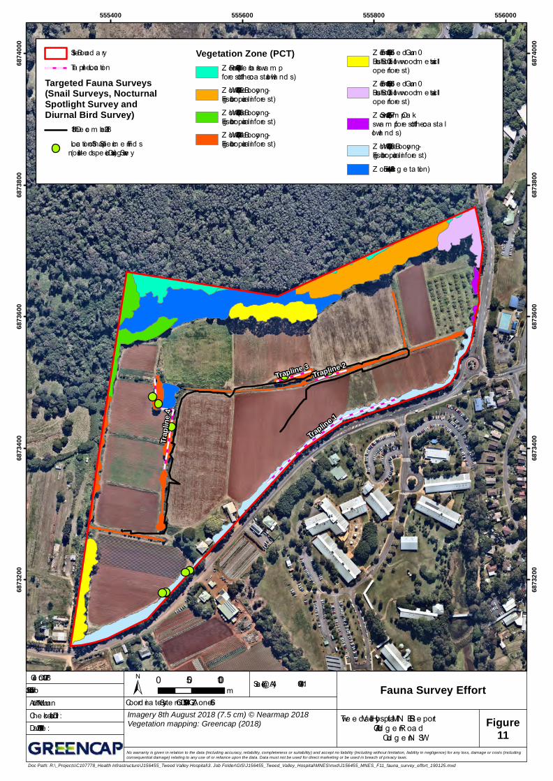
The Mitchell's rainforest snail (Thersites mitchellae) was recorded on Site in a portion of Zone 2 (one live specimen) opportunistically by Dr Licari and David Milledge. In addition, Mitchell's rainforest snail was recorded in several locations outside the Site boundary adjacent to the Site (Clark 2019; Greencap 2019).
A targeted survey for Mitchell’s rainforest snail that was undertaken by Dr Stephanie Clark, a specialist in invertebrate identification, and this survey concluded that rainforest habitat present in the windrows (Zones 4 and 8) was not suitable for the Mitchell’s rainforest snail and no evidence of their occurrence was recorded, therefore clearance of Zones 4 and 8 would not significantly impact Mitchell’s rainforest snail habitat. Additionally, proposed mitigation measures incorporate revegetation of the exotic grassland in Zone 9 (0.95 ha) with rainforest species and this could potentially provide additional habitat for the Mitchell's rainforest snail. It was therefore assessed that the Project will not have significant impacts on this species.
iv
Adelaide | Auckland | Brisbane | Canberra | Darwin | Melbourne | Newcastle | Perth | Sydney | Wollongong
greencap.com.au
Matters of National Environmental Significance Report
NSW Health Infrastructure Tweed Valley Hospital
Executive Summary ............................................................................................................................. i
Table 7 Response to EPBC Act Referral Guidelines for Koala (Vulnerable) ............................................. 30
Table 8 Criteria Response for the Pink Underwing Moth (Endangered Species) .................................... 32
Table 9 Criteria Response for the Southern Black-Throated Finch (Endangered Species) ...................... 34
Table 10 Avoiding and Minimising Impacts on Vegetation, Habitat and Biodiversity Values ................... 42
vi
greencap.com.au
Adelaide | Auckland | Brisbane | Canberra | Darwin | Melbourne | Newcastle | Perth | Sydney | Wollongong
Glossary, Acronyms and Abbreviations
Abbreviation Definition
BC Act Biodiversity Conservation Act 2016
BC Regulation Biodiversity Conservation Regulation 2016
BAM Biodiversity Assessment Method Order 2017
Coastal Management SEPP State Environmental Planning Policy (Coastal Management) 2018
CKPoM Tweed Coast Comprehensive Koala Plan of Management 2015
EEC Ecological communities that are listed as ‘endangered’ under the Biodiversity Conservation Act 2016.
EP&A Act Environmental Planning and Assessment Act 1979
EPBC Act Environmental Protection and Biodiversity Conservation Act 1999 (Cth)
LGA Local Government Area
OEH Office of Environment and Heritage
PCT Plant Community Type
PMF Probable Maximum Flood
PMST Protected Matters Search Tool
VI Vegetation Integrity
TEC Ecological communities that are listed as ‘threatened’ under the Environment Protection and Biodiversity Conservation Act 1999 and the Biodiversity Conservation Act 2016.
TSC Tweed Shire Council
1
greencap.com.au
Adelaide | Auckland | Brisbane | Canberra | Darwin | Melbourne | Newcastle | Perth | Sydney | Wollongong
1. INTRODUCTION
1.1 Overview
Greencap Pty Ltd (Greencap) was commissioned by TSA Management (TSA) on behalf of Health Infrastructure to prepare a report which documents an assessment of impacts on Matters of National Environmental Significance (MNES), as listed under the Environment Protection and Biodiversity Conservation Act 1999 (Cth) (EPBC Act) for the proposed development of the new Tweed Valley Hospital (the Project).
1.2 Background
The Northern Rivers is experiencing one of the fastest rates of population growth in New South Wales (NSW). The existing Tweed Hospital is at capacity and a range of clinical service and master planning studies have determined that the existing site is not able to meet the healthcare needs of a rapidly growing population and in particular the increase in the ageing population. The population of the Tweed and Byron Local Government Areas (LGAs) is expected to grow from some 119,100 people in 2011 to more than 147,000 in 2031, a growth rate of 24%.
Aside from the significant forecast population growth in the Tweed-Byron region, the need for the new hospital is being driven by the need for: local access to health care without having to travel beyond the region; delivery of high quality, modern health care services; capacity constraints at the existing hospital; inadequate land area to develop new facilities at the existing hospital; and access issues at the existing hospital during floods. Consequently, on 13 June 2017, the NSW Government announced $534 million for a new state-of-the-art Tweed Valley Hospital (the Project). A purpose-built referral hospital on a new site will ensure that the growing and changing healthcare needs of the Tweed-Byron community are provided for in the years to come. Furthermore, the proposed development will provide a net economic and employment benefit to the community.
Under the EPBC Act, actions that have or which are likely to have a significant impact on a MNES require referral to, and approval from, the Commonwealth. There are nine MNES listed in the EPBC Act that are potential grounds for referral. Of these, only two categories are relevant to the Project, as follows:
Listed threatened species and ecological communities; and
Migratory species protected under international agreements. The potential for MNES from these two categories to be present on the Site has been identified through a combination of previous desktop and field-based assessments.
This report assesses Project impacts on these categories in accordance with the general guidance provided in Matters of National Environmental Significance: Significant impact guidelines 1.1 Environment Protection and Biodiversity Conservation Act 1999 (Commonwealth of Australia, 2013) (Significant Impact Guidelines). In addition to the Significant Impact Guidelines, the Commonwealth has also released specific guidance for some listed ecological communities and EPBC Act listed species. These guidelines have been referred to, where applicable, for a particular ecological community or species that is relevant to the Site.
2
greencap.com.au
Adelaide | Auckland | Brisbane | Canberra | Darwin | Melbourne | Newcastle | Perth | Sydney | Wollongong
2. SUMMARY OF THE PROPOSED PROJECT AND SITE
In accordance with the Significant Impact Guidelines an ‘action’ is defined broadly in the EPBC Act to include: a project, a development, an undertaking, an activity or a series of activities, or an alteration of any of these things. The proposed action relevant to the Project encompasses site preparation, construction and operational activities.
The Project will include the following key activities that are relevant to the consideration of whether the action will lead to any potential, significant impacts on MNES:
The proposed clearing of 0.95 ha of self-sown windrow vegetation which may qualify as a Threatened Ecological Community (TEC);
Development of the new hospital facility, including green space and other amenities, campus roads and car parking, external road upgrades and connections, utilities connections, and other supporting infrastructure.
2.1 The Site
2.1.1 Overview
The Project is to be located at 771 Cudgen Road, Cudgen (Lot 11 DP 1246853) within the Tweed Shire Council LGA (Figure 1 and Figure 2) (the ‘Site’). The Site is defined in this report as the entire Lot 11 DP 1246853 (19.4 ha). The State Significant Development (SSD) application and supporting Environmental Impact Statement (EIS) refer to the Project Site (a 19.38 ha area of land) as part of the former single Lot 102 DP 870722.
The Site is located between the existing residential areas of Kingscliff and Cudgen, situated opposite Kingscliff TAFE. Approximately 16.4 ha of the Site is above the Probable Maximum Flood (PMF), a legislated requirement for hospital developments.
The northern section of the Site is located on the Tweed River floodplain and is part of an important local wetland (mapped under State Environmental Planning Policy (Coastal Management) 2018; Coastal Management SEPP).
The southern section of the Site is a working farm under cultivation (approximately 16.3 ha) and apart from the self-sown windrows along the Site boundary, most of the southern section has been cleared of native vegetation.
No Areas of Outstanding Biodiversity Value or areas of geological significance are located on the Site.
The original Biodiversity Assessment Method (BAM) assessment was conducted prior to the acquisition of the Project Site. This assessment identified PCTs, vegetation zones and Threatened Ecological Communities (TECs) for the former Lot 102 DP 870722. The current vegetation integrity scores for all vegetation zones was retained for the final version of the Biodiversity Development Assessment Report (BDAR) (Greencap 2019). For the purposes of this MNES report, the subject land (the Site) is defined as the Project Site (i.e. Lot 11 DP 1246853).
2.1.2 Site Selection
A two-phase site selection process was undertaken by Health Infrastructure to assess the suitability of a range of greenfield and brownfield sites for the development of the new hospital and more than 50 sites were assessed. In the first phase (August 2017 to March 2018), 35 sites were considered, including around 20 submitted by landowners through an Expression of Interest (EOI) process.
3
greencap.com.au
Adelaide | Auckland | Brisbane | Canberra | Darwin | Melbourne | Newcastle | Perth | Sydney | Wollongong
In recognition of community concerns raised as a result of the first phase, a second phase (April to June 2018) of the selection process sought feedback from the community.
The Site was selected at the end of June 2018 after an extensive due diligence that assessed the biodiversity values of the locations. Other locations were disregarded in favour of the Project’s proposed location due to the significant biodiversity values of those sites. The Site was selected because it was operating as an agricultural enterprise, and therefore the majority of remnant vegetation had already been cleared.
Those smaller parts of the Site that contain areas of higher biodiversity value, for example where remnant vegetation has been retained, were identified and removed from the development footprint. On this basis, the Project footprint has been located in an area that avoids directly impacting threatened species and TECs.
Those areas of the Site which are critical for connectivity, such as the northern section of the Site which falls within a mapped fauna corridor, will be maintained for their contribution to biodiversity values. Generally, the Project footprint will be situated in areas which have already been cleared. The only areas of native vegetation to be cleared are parts of the self-sown windrows in the southern section of the Site.
2.2 The Project
2.2.1 Overview
The development application for the Project consists of a State Significant Development application under Section 4.22 of the Environmental Planning and Assessment Act 1979 (NSW) (EP&A Act). In addition, all projects which are classified as State Significant Developments also require the preparation of a Biodiversity Development Assessment Report (BDAR) in accordance with the requirements of the NSW Biodiversity Conservation Act 2016 (BC Act).
The Project will consist of two Stages as follows:
A concept development application and detailed proposal for Stage 1 (early and enabling works); and
A second development application for Stage 2 works which will include detailed design, construction and operation of the Tweed Valley Hospital (Project Application).
The construction and operational footprint for the development is identified in Appendix B. A detailed description of the proposed staging of the development is provided in the following sections.
This MNES Report has been prepared based on the Project information made available for Stage 1.
2.2.2 Concept Proposal and Stage 1 Early and Enabling Works
This component seeks approval for a Concept Proposal of the Project and Stage 1 early and enabling works. The Concept Proposal is informed by service planning to 2031/32 and has an expected gross floor area in the range 55,000 m2 to 65,000 m2. Stage 1 includes early and enabling works (for Site clearance and preparation) and will comprise:
Construction compound for Stage 1 Works;
Augmentation and connection of permanent services for the new facility (water, sewer, electricity, telecommunications);
4
greencap.com.au
Adelaide | Auckland | Brisbane | Canberra | Darwin | Melbourne | Newcastle | Perth | Sydney | Wollongong
General clearance of Site vegetation within the footprint of construction works, including tree stumps;
Chipping of cleared vegetation (excluding weed species) to use on Site for ground stabilisation/ erosion control, or off-site disposal as required;
Bulk earthworks to establish the required site levels and create a stable landform in preparation for hospital construction;
Piling and associated works;
Stormwater and drainage infrastructure for the new facility;
Rehabilitation and revegetation of part of the wetland area;
Construction of internal road ways for use during construction and in preparation for final road formations in Stage 2; and
Retaining walls.
2.2.3 Stage 2: Hospital Delivery - Main Works and Operation
Stage 2 will include the detailed design, construction and operation of the Project. Stage 2 will be subject to a separate application following Stage 1.
3. SOURCES OF INFORMATION
Data and/or resources used or consulted in the assessment include:
BioNet Threatened Biodiversity Data Collection (TBDC);
BioNet Atlas;
BioNet Web Services;
OEH Data Portal;
Protected Matters Search Tool (PMST);
Commonwealth specific guidance for some listed ecological communities and EPBC Act listed species, available at www.environment.gov.au/epbc/publications;
Ecological constraints analysis prepared by Greencap as part of the planning proposal for the Project; and
Biodiversity Development Assessment Report (BDAR) prepared to meet the requirements of the Biodiversity Conservation Act 2017 (NSW) (BC Act). There is extensive cross-over between species listed under the EPBC Act and the BC Act. Preparation of the first version of the BDAR involved extensive field surveys across the Site.
Spatial data used or consulted in the assessment include:
Cadastre (NSW Department of Finance, Services and Innovation 2018);
IBRA Regions and Subregions (OEH 2016);
NSW (Mitchell) Landscapes - version 3.1 (OEH 2016);
5
greencap.com.au
Adelaide | Auckland | Brisbane | Canberra | Darwin | Melbourne | Newcastle | Perth | Sydney | Wollongong
Tweed Shire Council Vegetation Mapping - Tweed LGA Vegetation 2012. VIS_ID 3912 (Tweed Shire Council 2012);
SEPP Coastal Management (DPE 2018);
Directory of Important Wetlands in Australia (Australian Government Department of the Environment, Water, Heritage and the Arts
Fauna Corridors for North East NSW (OEH 2018);
Acid Sulfate Soils Risk map (OEH 1998);
NSW Hydrography (Department of Finance, Services and Innovation 2018); and
2018 Aerial imagery (Nearmap 2018).
Consultant reports or advice informing or referenced in the assessment (including those in draft form) include:
Tweed Valley Hospital MASTERPLAN CONCEPT PLAN AR-SKE-10-006[04] (STH Batessmart)
Tweed Valley Hospital Noise and Vibration Impact Assessment for State Significant Development (SSD) (Acoustic Studio);
Aviation SEARS response: Tweed Valley Hospital (AviPro);
Tweed Valley Hospital – Flooding Component DRAFT (BMT);
Tweed Valley Hospital Development Design Report (Bonacci Group NSW);
Tweed Valley Hospital Development Stormwater Management Proposal (Bonacci Group NSW);
Preliminary and Detailed Site Investigation (Octief);
Tweed Valley Hospital Landscape Masterplan Report draft (Turf Design Studio); and
Tweed Valley Hospital Project Traffic Impact Assessment (Bitzios Consulting).
Lot 11 DP1246853
ELROND DRIVE
CAMBRIDGE COURT
OXFORD STREETCUDGEN ROAD
TURNOCK STREET
TURNOCK STREET
QUIGAN STREET
YALESTREET
555400 555600 555800 55600068
7300
0
6873
000
6873
200
6873
200
6873
400
6873
400
6873
600
6873
600
6873
800
6873
800
6874
000
6874
000
Scale (@A4):
Author: M. Nunn
1:4,500Client: C107778
Checked: D. Licari
Date: 22/01/2019
Job #: J156455 ± 0 50 100m
Site Map(ref: s4.2.1.1 of BAM)
Tweed Valley Hospital MNES Report771 Cudgen Road
Cudgen NSW
No warranty is given in relation to the data (including accuracy, reliability, completeness or suitability) and accept no liability (including without limitation, liability in negligence) for any loss, damage or costs (includingconsequential damage) relating to any use of or reliance upon the data. Data must not be used for direct marketing or be used in breach of privacy laws.
No warranty is given in relation to the data (including accuracy, reliability, completeness or suitability) and accept no liability (including without limitation, liability in negligence) for any loss, damage or costs (includingconsequential damage) relating to any use of or reliance upon the data. Data must not be used for direct marketing or be used in breach of privacy laws.
Figure2
Site Boundary
1500m Buffer
Coordinate System: GDA 1994 MGA Zone 56
Doc Path: R:\_Projects\C107778_Health Infrastructure\J156455_Tweed Valley Hospital\3. Job Folder\GIS\J156455_Tweed_Valley_Hospital\MNES\mxd\J156455_MNES_F02_Location_Map_190122.mxd
Adelaide | Auckland | Brisbane | Canberra | Darwin | Melbourne | Newcastle | Perth | Sydney | Wollongong
4. DESCRIPTION OF THE REGIONAL AND SITE CHARACTERISTICS
4.1 Landscape Features
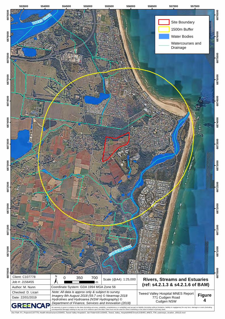
The defining geophysical feature of this region is the Mount Warning shield volcano, associated caldera and the Tweed River floodplain. The Site is in the South-East Queensland IBRA Bioregion and the Burringbar-Conondale Ranges IBRA Subregion. The southern section of the Site is located on the Lamington Volcanic Slopes NSW Landscapes which features extensive hills and ridges forming a generally circular pattern of radial drainage centred on Mount Warning. The northern section of the Site is located on the Byron-Tweed Alluvial Plains NSW Landscapes characterised by the watercourses, floodplain, terraces and estuary of the Tweed River (Department of Environment and Climate Change [DECC], 2002; Figure 3 and Figure 4).
The northern section of the Site is located on the Tweed River floodplain and is part of an important wetland mapped under the State Environmental Planning Policy (Coastal Management) 2018 (Coastal Management SEPP) (Figure 5). The wetland is not included in the Directory of Important wetlands and has been mapped with a 50 m riparian corridor.
The wetland is part of a mapped regional fauna corridor which may facilitate the movement of threatened species across their range (Department of Environment, Climate Change and Water [DECCW], 2010; Figure 6). At a local scale this forested wetland with associated rainforest components blends eastward into a coastal floodplain wetland (Keith, 2004) that extends to within 200 m of the coast (Figure 5).
This area is a significant stepping-stone habitat to the Cudgen Creek estuary located some 800 m to the south-east of the Site. A constructed, east-flowing floodplain drain drains the catchment and strikes roughly north-east through the northernmost portion of the Site (Figure 3). Based on mapping provided in the NSW Hydrography dataset, Strahler stream ordering could not be determined. However, with reference to stream order data for the Nambucca Catchment (Department of Infrastructure, Planning and Natural Resources 2005), it was assumed that the drain would constitute a 1st or 2nd order stream at most and has been mapped with a conservative 20 m riparian corridor.
The southern section of the Site is a working farm under cultivation (approximately 16.3 ha) and apart from the windrows planted along the Site boundary, most of the southern section of the Site has been cleared of native vegetation.
4.2 Native Vegetation
4.2.1 Vegetation Class
Observations of the vegetation formation from field surveys conducted by Greencap and correlation with the BioNet Vegetation Classification (OEH, 2018) determined four vegetation classes present at the Site: Coastal Swamp Forest, Coastal Floodplain Wetlands, Subtropical Rainforest and North Coast Wet Sclerophyll Forest (Table 1).
The remnant vegetation on Site is Coastal Swamp Forest and Subtropical Rainforest with North Coast Wet Sclerophyll Forest and Coastal Floodplain Wetlands recorded in planted windrows. Windrow vegetation that has self-sown on the linear rock mounds throughout the Site consists of derived early regrowth native rainforest species and woody weeds classified as High Treat Exotics. An exotic grassland monoculture composed of barner grass Cenchrus purpureus is located amongst derived and remnant native vegetation in the northern section of the Site.
9
greencap.com.au
Adelaide | Auckland | Brisbane | Canberra | Darwin | Melbourne | Newcastle | Perth | Sydney | Wollongong
4.2.2 Vegetation Formations
Observations from field surveys conducted by Greencap indicated the presence of two distinct areas of vegetation. The northern section of the Site that is located on the floodplain is substantially remnant native vegetation. Above the level of the floodplain, the southern section of the Site that is located on a ridge is land that has been cleared of native vegetation. Vegetation formations recorded on the site and presented below are classified in accordance with Keith (2004).
The northern section of the Site is remnant vegetation classified as forested wetland and rainforest formations. Adjoining the remnant vegetation is a large patch of exotic vegetation near the north-west corner and planted eucalypt windrows classified as wet sclerophyll forest shrubby sub-formation. Along the southern edge of this vegetation and extending roughly west to east across the Site rocks that have been cleared from the cultivated fields have formed a steep slope and in some areas have been fashioned into a dry-stone wall up to 3 m high.
Most of the southern section of the Site is cleared land under cultivation. Rocks that have been cleared from the cultivated fields have been piled into linear mounds composed of loosely consolidated rock and soil throughout the Site. Early regrowth rainforest species and woody weeds that are classified as high threat exotics have self-sown in these areas to form windrows classified as rainforest. Along the Cudgen Road/Turnock Street boundary there is a planted slash pine Pinus elliottii windrow with an understory also composed of self-sown early regrowth rainforest species and woody weeds. There is also a planted eucalypt windrow in the south-west corner of the Site classified as wet sclerophyll forest shrubby sub-formation. On the eastern boundary of the Site there is a planted casuarina windrow classified as a forested wetland.
4.2.3 Identification of Draft Plant Community Types and Draft Vegetation Zones
Native vegetation communities within the Tweed LGA was mapped in a study commissioned by Tweed Shire Council (Ecograph, 2004) and updated in 2012 (TSC 2012). Originally based on 1996 aerial photography and updated based on 2009 aerial photography, this mapping was conducted at a nominal scale of 1:25000 with a boundary precision of +/-25 m. Consequently, remnant vegetation patches of < 1 ha or connections < 25 m wide could not be resolved (Ecograph, 2004; TSC, 2012).
In conjunction with observations from the initial site inspection, the above vegetation mapping layers were used to conduct an initial assessment of native vegetation extent on the Site, determine draft Plant Community Types (PCT) and then stratify these draft PCTs into draft Vegetation Zones (Table 1). For the planted and self-sown windrow vegetation, a draft PCT was assigned which was the most likely original PCT as determined by the assessor.
The entire list of PCTs located on the BioNet Vegetation Classification website (OEH 2018) were exported to facilitate PCT identification. The Data>Filter menu options in Microsoft Excel was used to filter column headings to identify PCTs.
The TECs identified on the Site are outlined in Section 5.1.1.
4.2.4 Plot-Based Vegetation Surveys
A systematic field-based floristic vegetation survey using documented and repeatable methods was employed to collect floristic data at the Site in accordance with Tables 2 to 4, Section 5.2.1.8 (b-e) to 5.2.1.11 and Section 5.3 of the BAM. The vegetation survey was designed to survey the expected environmental variation in each draft PCT, the expected environmental variation in each stratified draft vegetation zone and to fill gaps in existing mapping and site information.
10
greencap.com.au
Adelaide | Auckland | Brisbane | Canberra | Darwin | Melbourne | Newcastle | Perth | Sydney | Wollongong
Given the relatively small area of each draft PCT (i.e. PCT 1064 = 3.8 ha; PCT 1302 = 2.6 ha; PCT 1569 = 0.7 ha; and PCT 1235 = 0.4 ha), it was considered that the environmental variation on the Site is minimal. Also, given that much of the native vegetation within the development footprint is either derived, planted or self-sown windrows and small in area (Figure 7 and Table 1), the environmental variation in each stratified draft vegetation zone is also minimal. Accordingly, it was considered that a survey effort for each vegetation zone that is in accordance with the minimum number of plots that is indicated in Table 4 of the BAM was appropriate.
Floristic composition data was collected for each vascular plant species recorded in a 400 m2 plot (standard 20 m x 20 m or linear 10 m x 40 m) in accordance with Table 2, Table 3 and Sections 5.3.4.8 to 5.3.4.12 of the BAM and included:
Species name – Scientific (Genus species) and common name (Table 2 of the BAM);
Status – Species status: native, exotic or high threat exotic (Section 5.3.4.11 of the BAM); and
Growth form – Growth form classes: tree, shrub, grass and grass like, forb, fern and other (Table 2 of the BAM).
Floristic structure data for cover, abundance and stratum in a 400 m2 plot (standard 20 m x 20 m or linear 10 m x 40 m) was collected for the following attributes in accordance with Table 2, Section 5.3.4.8 and Sections 5.3.4.13 to 5.3.4.17 of the BAM and included:
Cover – Percent foliage cover across the plot for each species rooted in or overhanging the plot (Section 5.3.4.13 of the BAM);
Abundance – For species with ≤5% cover an estimate of the number of individuals or shoots of each species was recorded (Table 2 of the BAM); and
Stratum – Vegetation layers: upper, middle and ground stratum (Table 2 of the BAM).
Floristic function data for the number of large trees, stem size class, tree regeneration and length fallen logs in a 1000 m2 plot (standard 20 m x 50 m or linear 10 m x 100 m) in accordance with Table 3, Section 5.3.4.8 and Sections 5.3.4.18 to 5.3.4.30 of the BAM and included:
Number of large trees – With reference to the appropriate large tree benchmark for each PCT;
Tree regeneration – Presence or absence of living trees with < 5 cm diameter at breast height over bark (DBH);
Tree stem size class – 5-9, 10-19, 20-29, 30-49, 50-79 and >80 cm DBH;
Length of fallen logs – Total length in metres of all woody material > 10 cm in diameter and >50 cm in length;
Litter cover – Assessed as the average percentage ground cover of litter recorded in five 1 m2 plots evenly located along the central transect; and
Trees with hollows – Count of the number of trees with hollows that are visible from the ground.
Plot data was collected in the Fulcrum application on a mobile device with GPS capability or on handwritten field sheets. Data that was collected on handwritten field sheets was immediately entered into Fulcrum. Data that was entered into Fulcrum was then downloaded into Microsoft Excel for ease of data manipulation.
11
greencap.com.au
Adelaide | Auckland | Brisbane | Canberra | Darwin | Melbourne | Newcastle | Perth | Sydney | Wollongong
Over the course of the vegetation surveys the boundaries of the draft vegetation zone were confirmed by annotating a paper-based map that indicated the base map and draft vegetation zones with the assistance of the Fulcrum application on a mobile device with GPS capability. This handwritten data was then digitised using a GIS application.
Samples of plant species that were not readily identifiable in the field were identified in the lab with the aid of field guides and botanical keys. Those plant species which could not be identified in the lab were identified by the Queensland Herbarium. Once identified, the plant species that were identified in the lab and by the herbarium were transferred into Microsoft Excel.
The flooded gum E. grandis dominated windrow that is located in Zone 5 was planted on the edge of a dry-stone wall. On this basis, it was considered as an unsafe area to work in. Consequently, a plot was placed in the windrow in the south-west corner of the Site within the same Vegetation Zone.
The slash pine Pinus ellioti windrow is considered to be exotic vegetation and not assessable under the BAM. However, given that derived native vegetation composed of early regrowth rainforest species grows in the understory and the BAM requirement to assess occurrence of threatened species across the Site, a plot based survey was conducted in this area as a precaution (Table 1; Zone 8).
Observations from both initial and subsequent Site inspections indicated that vegetation in Zone 9 is exotic vegetation consisting of a barner grass Cenchrus purpureus monoculture (3-4m tall) that does not contain native vegetation as well as a small patch of camphor laurel Cinnamomum camphora with an understorey of small-leaf privet Ligustrum sinense which does not require assessment (Table 1). Consequently, no BAM plots were established within this vegetation zone.
4.2.5 Confirmation of PCTs, Vegetation Zones and Ecological Communities
A combination of the quantitative data recorded in the plot-based floristic vegetation surveys outlined in Section 4.2.4, mapping data and Site observations was then used to confirm the identification of PCTs and Vegetation Zones detailed in Section 4.2.3. Following confirmation of PCTs the extent of native vegetation on the Site and the location of vegetation zones was then mapped (Figure 7).
12
greencap.com.au
Adelaide | Auckland | Brisbane | Canberra | Darwin | Melbourne | Newcastle | Perth | Sydney | Wollongong
Table 1 Plant Community Types, Vegetation Zones and Number of BAM Plots
PCT PCT Common Name Vegetation Zone
Description and condition Condition class
Area (ha)
No. of plots
BAM plot number. and survey date
1064 Paperbark swamp forest of the coastal lowlands of the NSW North Coast Bioregion and Sydney Basin Bioregion
1 Coastal Swamp Forest in moderate condition
Moderate 0.29 2 16 – 10 July 2018 19 – 15 June 2018
1302 White Booyong – Fig subtropical rainforest of the NSW North Coast Bioregion
2 Subtropical Rainforest in moderate condition
Moderate 0.73 1 11 – 11 July 2018
3 Derived regenerating Subtropical Rainforest in low condition, most likely original PCT.
Low 0.36 1 103 – 3 September 2018
4 Derived regenerating Subtropical Rainforest in low condition, most likely original PCT.
Derived 0.61 1 99 – 11 July 2018
1569 Flooded Gum – Brush Box – Tallowwood mesic tall open forest on ranges of the lower North Coast
5 Planted North Coast Wet Sclerophyll Forest in low condition, best matching PCT based on local species present
Derived 0.57 1 102 – 15 August 2018
6 Planted North Coast Wet Sclerophyll Forest in low condition, best matching PCT based on local species present.
Derived 0.29 1 101 – 15 August 2018
13
greencap.com.au
Adelaide | Auckland | Brisbane | Canberra | Darwin | Melbourne | Newcastle | Perth | Sydney | Wollongong
PCT PCT Common Name Vegetation Zone
Description and condition Condition class
Area (ha)
No. of plots
BAM plot number. and survey date
1235 Swamp Oak swamp forest of the coastal lowlands of the NSW North Coast Bioregion
7 Planted Coastal Swamp Forest in low condition, best matching PCT based on local species present
Derived 0.05 1 100 – 15 August 2018
1302 White Booyong – Fig subtropical rainforest of the NSW North Coast Bioregion
8 Pinus sp. windrow with understorey of derived regenerating Subtropical Rainforest in low condition, most likely original PCT
9 Cenchrus purpureus monoculture with Cinnamomum camphora and Ligustrum sinense
N/A 1.02 0 N/A
555400 555600 555800 55600068
7320
0
6873
200
6873
400
6873
400
6873
600
6873
600
6873
800
6873
800
6874
000
6874
000
Scale (@A4):
Author: M. Nunn
1:4,000Client: C107778
Checked: D. Licari
Date: 22/01/2019
Job #: J156455 ± 0 50 100m
No warranty is given in relation to the data (including accuracy, reliability, completeness or suitability) and accept no liability (including without limitation, liability in negligence) for any loss, damage or costs (includingconsequential damage) relating to any use of or reliance upon the data. Data must not be used for direct marketing or be used in breach of privacy laws.
Figure3
Site Boundary
Water Bodies
Watercourses andDrainage
Riparian Corridor
Coordinate System: GDA 1994 MGA Zone 56
Doc Path: R:\_Projects\C107778_Health Infrastructure\J156455_Tweed Valley Hospital\3. Job Folder\GIS\J156455_Tweed_Valley_Hospital\MNES\mxd\J156455_MNES_F03_waterways_site_190122.mxd
Rivers, Streams and Estuaries(ref: s4.2.1.3 & s4.2.1.6 of BAM)
Rivers, Streams and Estuaries(ref: s4.2.1.3 & s4.2.1.6 of BAM)
No warranty is given in relation to the data (including accuracy, reliability, completeness or suitability) and accept no liability (including without limitation, liability in negligence) for any loss, damage or costs (includingconsequential damage) relating to any use of or reliance upon the data. Data must not be used for direct marketing or be used in breach of privacy laws.
Figure4
Site Boundary
1500m Buffer
Water Bodies
Watercourses andDrainage
Coordinate System: GDA 1994 MGA Zone 56
Doc Path: R:\_Projects\C107778_Health Infrastructure\J156455_Tweed Valley Hospital\3. Job Folder\GIS\J156455_Tweed_Valley_Hospital\MNES\mxd\J156455_MNES_F04_waterways_location_190122.mxd
No warranty is given in relation to the data (including accuracy, reliability, completeness or suitability) and accept no liability (including without limitation, liability in negligence) for any loss, damage or costs (includingconsequential damage) relating to any use of or reliance upon the data. Data must not be used for direct marketing or be used in breach of privacy laws.
Habitat Connectivity(ref: s4.2.1.3d & s4.2.1.9 of BAM)
No warranty is given in relation to the data (including accuracy, reliability, completeness or suitability) and accept no liability (including without limitation, liability in negligence) for any loss, damage or costs (includingconsequential damage) relating to any use of or reliance upon the data. Data must not be used for direct marketing or be used in breach of privacy laws.
Figure6
Site Boundary
1500m Buffer
Fauna CorridorRegional FaunaCorridor
Subregional FaunaCorridor
Coordinate System: GDA 1994 MGA Zone 56
Doc Path: R:\_Projects\C107778_Health Infrastructure\J156455_Tweed Valley Hospital\3. Job Folder\GIS\J156455_Tweed_Valley_Hospital\MNES\mxd\J156455_MNES_F06_connectivity_location_190122.mxd
No warranty is given in relation to the data (including accuracy, reliability, completeness or suitability) and accept no liability (including without limitation, liability in negligence) for any loss, damage or costs (includingconsequential damage) relating to any use of or reliance upon the data. Data must not be used for direct marketing or be used in breach of privacy laws.
Figure7
Site Bound a ryVegetation Zone (PCT)
Z one 1 (1064 -Pa pe rba rk swa m p fore stof the coa sta l lowla nd s)Z one 2 (1302 - WhiteBooyong - Figsubtropica l ra infore st)Z one 3 (1302 - WhiteBooyong - Figsubtropica l ra infore st)Z one 4 (1302 - WhiteBooyong - Figsubtropica l ra infore st)
Z one 5 (1569 - Flood e dGum – Brush Box –Ta llowwood m e sic ta llope n fore st)Z one 6 (1569 - Flood e dGum – Brush Box –Ta llowwood m e sic ta llope n fore st)Z one 7 (1235 - Swa m pOa k swa m p fore st of thecoa sta l lowla nd s)Z one 8 (1302 - WhiteBooyong - Figsubtropica l ra infore st)
Coord ina te Syste m : GDA 1994 MGA Z one 56
Doc Path: R:\_Projects\C107778_Health Infrastructure\J156455_Tweed Valley Hospital\3. Job Folder\GIS\J156455_Tweed_Valley_Hospital\MNES\mxd\J156455_MNES_F07_native_vege_Site_190122.mxd
No warranty is given in relation to the data (including accuracy, reliability, completeness or suitability) and accept no liability (including without limitation, liability in negligence) for any loss, damage or costs (includingconsequential damage) relating to any use of or reliance upon the data. Data must not be used for direct marketing or be used in breach of privacy laws.
Figure8
Site Boundary
1500m Buffer
Native Vegetation
Coordinate System: GDA 1994 MGA Zone 56
Doc Path: R:\_Projects\C107778_Health Infrastructure\J156455_Tweed Valley Hospital\3. Job Folder\GIS\J156455_Tweed_Valley_Hospital\MNES\mxd\J156455_MNES_F08_native_vege_location_190122.mxd
Adelaide | Auckland | Brisbane | Canberra | Darwin | Melbourne | Newcastle | Perth | Sydney | Wollongong
5. IMPACTS ON ECOLOGICAL COMMUNITIES, MIGRATORY SPECIES AND THREATENED SPECIES
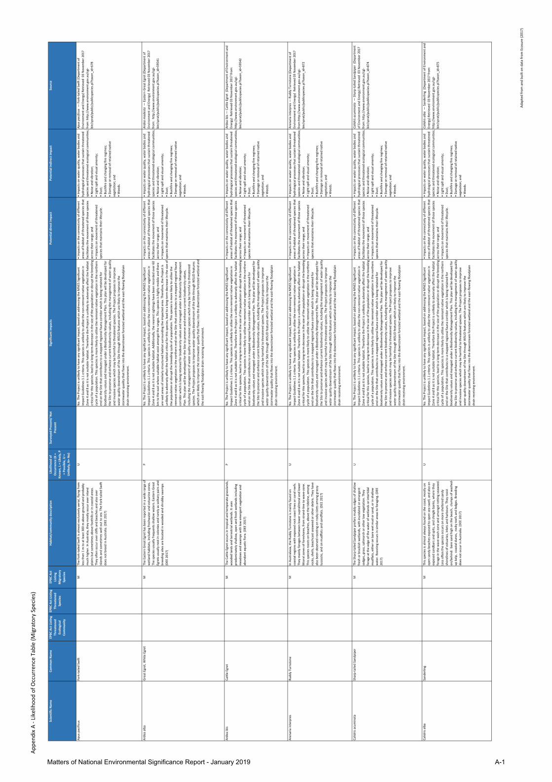
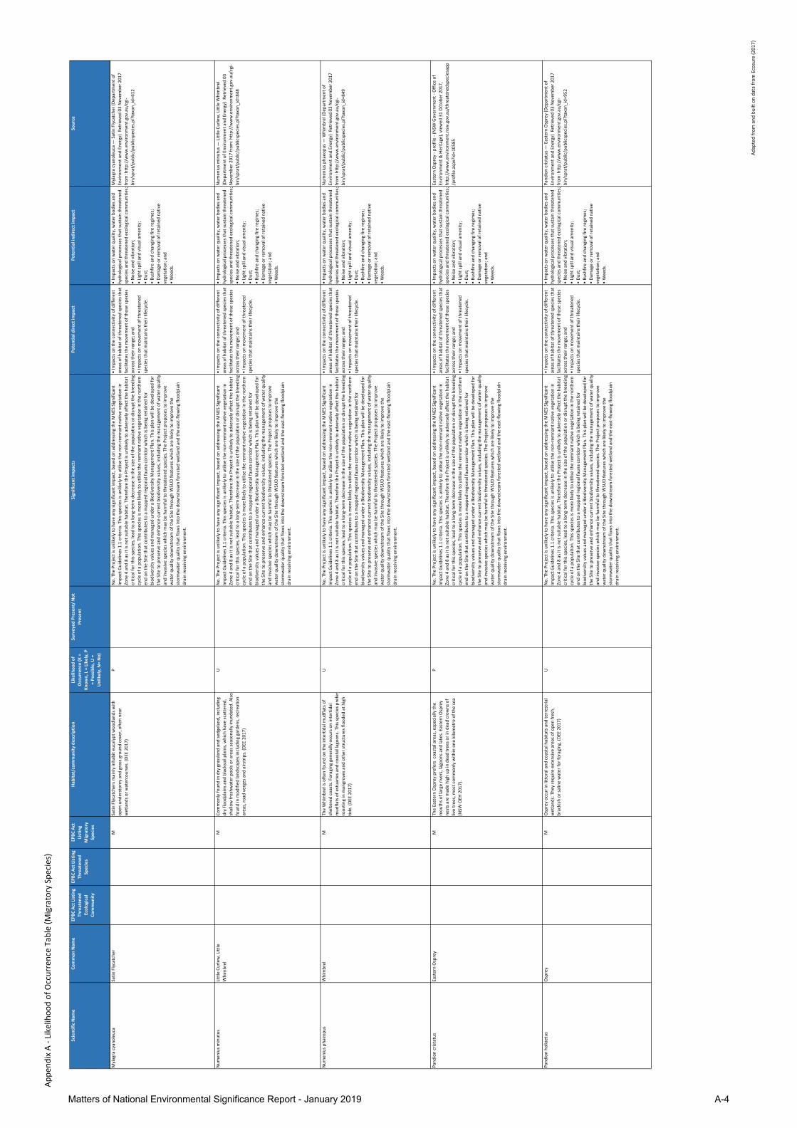
On 22 January 2019, the EPBC Acts Protected Matters Search Tool (PMST) was used to generate a report to determine whether any MNES were likely to occur within a 5 km radius of the Site. The MNES that relate to listed threatened species, TECs and migratory species were included in the search.
The listed threatened species and migratory species that were identified in the PMST report were filtered to remove species such as marine species that were captured in the 5 km buffer but not relevant to the Site. Based on the PMST and site survey data, threatened and migratory species that were identified in the report were assigned a categorical likelihood of occurrence on the Site (i.e. known, likely, possible, unlikely and not present) based on actual observations and/or the presence of habitat that would be suitable to support the particular species.
It is important to note that in accordance with the EPBC Act:
Species in the extinct and conservation dependant categories of species listed under the EPBC Act and listed ecological communities in the vulnerable category of ecological communities listed under the EPBC Act, are not matters of national environmental significance for the purposes of Part 3 of the EPBC Act (requirements for environmental approvals).
Species and ecological communities listed under the EPBC Act may differ from those listed under State and Territory legislation. This is due to the different status of some species and ecological communities in the different States and Territories, and nationally.
5.1 Matters of National Environmental Significance Assessment
5.1.1 Threatened Ecological Communities
Based on the PMST, three TECs were listed under the EPBC Act as likely to occur within a 5 km radius of the Site. Based on data collected during plot-based surveys undertaken as part of the BDAR (Greencap 2019), two potential TECs were recorded on the Site, namely; the critically endangered Lowland Rainforest of Subtropical Australia in Zones 2, 3, 4 and 8 and the endangered Coastal Swamp Oak (Casuarina glauca) Forest of New South Wales and South East Queensland ecological community in Zone 7 (Appendix A). Based on plot survey data (see Section 4.2.4, Appendix C and Appendix D), the vegetation did not meet the minimum TEC threshold criteria for either of the two potential TECs. However, as a precautionary approach, the area of remnant rainforest vegetation in Zone 2 and 3 (1.09 ha outside the development footprint), is to be considered for its conservation significance and as an area critical for connectivity within a mapped fauna corridor. This vegetation will be retained and maintained to enhance and conserve its biodiversity values, with any residual impacts mitigated are described in Section 5.4 and in Appendix E. Additionally, the area of weedy vegetation in Zone 9 will be rehabilitated with rainforest vegetation as outlined in Section 5.4 and Table 10. The assessment against the listing advice threshold criteria for each TEC is outlined below.
Lowland Rainforest of Subtropical Australia
Condition thresholds are outlined in the listing advice for the Lowland Rainforest of Subtropical Australia and are the minimum level at which patches are to be considered under the EPBC Act for actions that may require referral to the Australian Government (TSSC 2011). National listing focuses legal protection on patches of the ecological community that are most functional, relatively natural and in relatively good condition. Condition thresholds help identify both the ecological community and ecological function using a set of criteria that assist in indicating when the EPBC Act is likely to apply to an ecological community.
21
greencap.com.au
Adelaide | Auckland | Brisbane | Canberra | Darwin | Melbourne | Newcastle | Perth | Sydney | Wollongong
Thresholds provide guidance for when a TEC patch retains sufficient conservation value to be considered as a MNES as defined under the EPBC Act. Therefore, the referral provisions of the EPBC Act are focussed on the most valuable elements of Australia’s natural environment, while heavily degraded or modified patches will be largely excluded (TSSC 2011).
Based on these considerations, an assessment was undertaken using the plot based survey data to determine whether the Lowland Rainforest of Subtropical Australia qualifies under the condition thresholds to be considered a MNES that would warrant referral (Table 2).
The findings of this assessment can be summarised as follows:
The vegetation condition of the non-remnant (derived) vegetation (patch type C) in the self-sown windrows in Zone 4 and 8 (1.36 ha in extent) does not meet all of the referral criteria condition thresholds, in particular the minimum patch size threshold of ≥ 2 ha, species richness and total native vegetation cover (Table 2); and
The remnant Lowland Rainforest of Subtropical Australia vegetation (patch type A and B) in the northern portion of the Site (Zone 2 and 3), which is classed as moderate to low condition and contributes to the mapped regional fauna corridor (Figure 6), does not meet all of the referral criteria condition thresholds (Table 2). Based on the BAM plot survey data, species richness and total native vegetation cover do not meet the thresholds for Zone 2 and patch size and species richness do not meet the thresholds for Zone 3. Therefore, these zones do not qualify under all the condition thresholds to be considered MNES.
Criteria Lowland Rainforest of Subtropical Australia
vegetation:
Natural remnant patches (Zone 2)
Lowland Rainforest of Subtropical Australia
vegetation:
Natural remnant patches (Zone 3)
Lowland Rainforest of Subtropical Australia
vegetation:
Self-sown windrows (Zone 4 and 8)
Patch type A - Natural remnant evident by the persistence of mature residual trees from Appendix B.
B - Some residual trees from Appendix B are present plus evidence of either;
natural regeneration
AND/OR
regeneration with active management
C - Non-remnant that has recovered through natural regeneration.
Patch size Total area of 0.731 ha does meet the minimum patch size threshold of ≥ 0.1 ha.
Total area of 0.361 ha does not meet the minimum patch size threshold of ≥ 1 ha.
Total area of windrow vegetation is 1.361 ha and this does not meet the minimum patch size threshold of ≥ 2 ha.
Canopy cover2 Mean canopy cover does meet the ≥ 70% threshold.
Mean canopy cover does meet the ≥ 70% threshold.
Mean canopy cover does meet the ≥ 70% threshold.
Species richness Species richness was 13 species in total which does not meet the ≥ 40 native woody species threshold.
Species richness was 16 species in total which does not meet the ≥ 30 native woody species threshold.
Species richness was 10 total species which does not meet the ≥ 30 native woody species threshold.
Percent of total vegetation cover that is native
Total native vegetation cover was 61% which does not meet the ≥70% of native vegetation threshold.
Total native vegetation cover was 50% which meets the ≥50% of native vegetation threshold.
Total native vegetation cover was 44% which does not meet the ≥50% of native vegetation threshold.
1 Patch size was determined based on the native vegetation within the site (Lot 11 DP 1246853).
2 Canopy cover was determined based on visual assessment of aerial imagery.
22
greencap.com.au
Adelaide | Auckland | Brisbane | Canberra | Darwin | Melbourne | Newcastle | Perth | Sydney | Wollongong
Coastal Swamp Oak (Casuarina glauca) Forest of New South Wales and South East Queensland ecological community
The ‘Conservation advice (incorporating listing advice) for the Coastal Swamp Oak (Casuarina glauca) Forest of New South Wales and South East Queensland ecological community’ outlines the key diagnostic features, condition thresholds and supplementary information to identify a patch of native vegetation as being a TEC and to determine whether the referral, assessment, approval and compliance provisions under national environmental law are likely to apply to a patch. Condition thresholds, classes and categories provide guidance on whether a patch retains sufficient conservation values to be considered as a MNES.
In order to be considered a MNES, areas of the ecological community must meet both the key diagnostic characteristics and at least the minimum condition thresholds for Category C. Very small or degraded patches that do not meet the minimum condition thresholds will be excluded from national protection (DEE 2018).
The vegetation condition of the derived vegetation in the windrow in Zone 7 (PCT1235 Swamp Oak swamp forest; 0.05 ha in extent) does not meet all of the referral criteria condition thresholds for a small patch, in particular the minimum patch size threshold of ≥ 0.5 ha. Furthermore, the vegetation in Zone 7 is a planted Casuarina glauca windrow located on a ridge, growing in red-brown silty clay soil derived from basalt. The Department of the Environment and Energy (2018) conservation advice (incorporating listing advice) describes that this TEC is associated with grey-back clay loams and sandy loams, on saturated, waterlogged or inundated low-lying alluvial flats and drainage lines associated with coastal floodplains. Consequently, PCT1235 Swamp Oak swamp forest does not conform to the 'Coastal Swamp Oak (Casuarina glauca) Forest of New South Wales and South East Queensland ecological community' description (DEE 2008).
5.1.2 Listed Migratory Species
Based on the PMST, a total of 29 migratory species potentially occur within a 5 km radius of the Site (Appendix A). However, it was assessed that listed migratory species are unlikely to occur on Site and would therefore not be directly impacted by the Project.
5.1.3 Threatened Species
Based on the PMST, a total of 57 threatened species (32 fauna species and 25 flora species) could potentially within a 5 km radius of the Site. An assessment of each species is outlined in Appendix A and covers the description of the habitat preferences, habitat suitability, likelihood of occurrence and likely consequence of any impacts of the Project on these species. A summary of the findings is outlined below. For each MNES threatened species outlined below, the potential impacts have been summarised based on addressing the MNES Significant Impact Guidelines criteria. In addition to this a detailed risk assessment describing mitigation measures (including timing, frequency and responsibility) proposed to manage the direct and indirect impacts during both the construction and operation phases of the Project are described in Section 5.4 and in Appendix E.
Plants
Of the 25 threatened flora species that were likely to occur in the area, only three individuals of the three-veined laurel Cryptocarya foetida were recorded on Site during the targeted surveys as shown in Figure 9 (Greencap 2019).
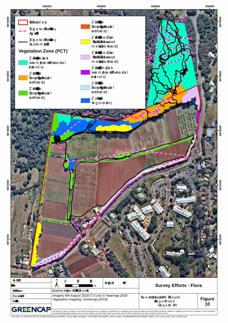
Targeted flora species surveys in Zones 1 to 8 were undertaken on 16 August 2018 by Dr Damian Licari and Annette McKinley and again on 3 September 2018 by Annette McKinley and Christina Maloney, under the direction of Dr Licari, with a survey effort of 32 hours.
23
greencap.com.au
Adelaide | Auckland | Brisbane | Canberra | Darwin | Melbourne | Newcastle | Perth | Sydney | Wollongong
Targeted flora surveys were undertaken by assessing all areas of native vegetation on the Site. Targeted flora survey tracks are mapped in Figure 10. Note that only the GPS data for the Greencap observer has been provided. An equipment malfunction on the 16th August 2018 meant that the full survey extent was not captured, notably the survey in the Zones 4 and 8.
In Zones 1 to 3, due to the thick swamp and rainforest vegetation with logs on the ground, it was difficult to walk parallel traverses in accordance with published guidelines (OEH 2016). However, with 32 hours of survey effort with two observers used in tandem on two separate days with a total of 32 surveys hours, and given that Zones 1-3 will not be directly impacted by the Project, this was considered to be sufficient and in broad accordance with the guidelines. The length of each windrow in Zones 4 to 8 were inspected from an edge and in cases where a portion of a windrow was too wide for effective inspection from an edge, these areas were inspected from within the windrow.
Additional targeted flora surveys for threatened plant species, including Carronia multisepalea (host plant for the Southern Pink Underwing Moth Phyllodes imperialis southern subspecies) were undertaken on 17 December 2018 by Dr Barbara Stewart in Zones 4 and 8 under the direction of Dr Licari, with a survey effort of four hours. In Zones 1 to 3 parallel traverses were walked at 10 m intervals in accordance with published guidelines (OEH 2016). The length of each windrow in Zones 4 to 8 were inspected from an edge and in cases where a portion of a windrow was too wide for effective inspection from an edge, these areas were inspected from within the windrow.
Table 3 below outlines the potential impacts on this species based on addressing the MNES Significant Impact Guidelines 1.1 criteria.
Table 3 Criteria Response for Cryptocarya foetida (Vulnerable Species)
Significant impact Criteria Response
Lead to a long-term decrease in the size of an important population of a species
Three three-veined laurel Cryptocarya foetida plants were recorded during the targeted flora surveys, with two plants in Zone 8 and one plant in Zone 2. However, considering the low count of individual plants (two), the small magnitude the vegetation proposed to be cleared (0.34 ha) and the fragmented location of the plants, the Project is unlikely to adversely affect the habitat critical for this species survival.
Mitigation measures to avoid or reduce impacts of the Project on Three three-veined laurel are outlined in detail in Table 10 and possible indirect impacts of the Project have been avoided and mitigated to a low residual risk level, as described in Appendix E.
Reduce the area of occupancy of an important population
The two individual plants recorded in Zone 8 do not represent an important population.
Fragment an existing population into two or more populations
Given that the two plants in Zone 8 are already in low condition windrow vegetation, the direct impact on these plants will not fragment an existing important population into two or more populations.
Adversely affect the habitat critical to the survival of the species
Considering the low count of individual plants (two) found in the area proposed to be cleared (Zone 4 and 8) and the small magnitude the vegetation proposed to be cleared (0.95 ha), the Project is unlikely to adversely affect the habitat critical to the survival this species.
Disrupt the breeding cycle of an important population
The removal of portion of Zone 8 is not likely to disrupt the breeding cycle of an important population, including impacts on genetic diversity.
24
greencap.com.au
Adelaide | Auckland | Brisbane | Canberra | Darwin | Melbourne | Newcastle | Perth | Sydney | Wollongong
Significant impact Criteria Response
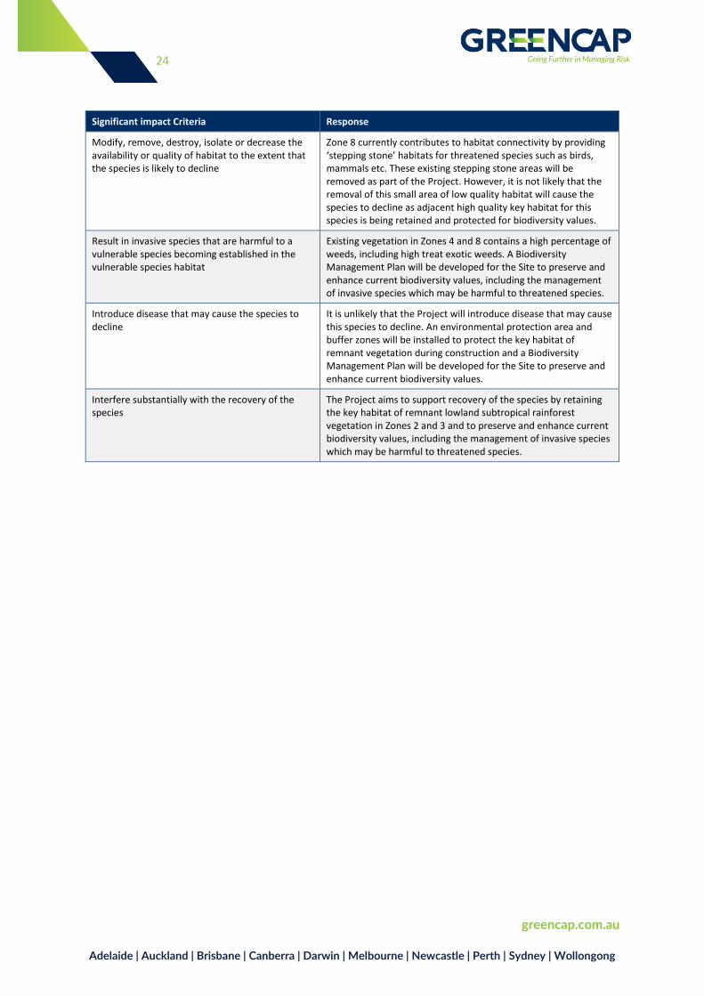
Modify, remove, destroy, isolate or decrease the availability or quality of habitat to the extent that the species is likely to decline
Zone 8 currently contributes to habitat connectivity by providing ‘stepping stone’ habitats for threatened species such as birds, mammals etc. These existing stepping stone areas will be removed as part of the Project. However, it is not likely that the removal of this small area of low quality habitat will cause the species to decline as adjacent high quality key habitat for this species is being retained and protected for biodiversity values.
Result in invasive species that are harmful to a vulnerable species becoming established in the vulnerable species habitat
Existing vegetation in Zones 4 and 8 contains a high percentage of weeds, including high treat exotic weeds. A Biodiversity Management Plan will be developed for the Site to preserve and enhance current biodiversity values, including the management of invasive species which may be harmful to threatened species.
Introduce disease that may cause the species to decline
It is unlikely that the Project will introduce disease that may cause this species to decline. An environmental protection area and buffer zones will be installed to protect the key habitat of remnant vegetation during construction and a Biodiversity Management Plan will be developed for the Site to preserve and enhance current biodiversity values.
Interfere substantially with the recovery of the species
The Project aims to support recovery of the species by retaining the key habitat of remnant lowland subtropical rainforest vegetation in Zones 2 and 3 and to preserve and enhance current biodiversity values, including the management of invasive species which may be harmful to threatened species.
!(
!(
!(
!(
!(
!(
555400 555600 555800 55600068
7320
0
6873
200
6873
400
6873
400
6873
600
6873
600
6873
800
6873
800
6874
000
6874
000
Scale (@A4):
Author: M . Nunn
1:4,000Clie nt: C107778
Che c ke d : D. LicariDate : 24/01/2019
Job #: J156455 ± 0 50 100m
No warranty is given in relation to the data (including accuracy, reliability, completeness or suitability) and accept no liability (including without limitation, liability in negligence) for any loss, damage or costs (includingconsequential damage) relating to any use of or reliance upon the data. Data must not be used for direct marketing or be used in breach of privacy laws.
Figure9
Site Boundary
!(Thersites mitchellae(M itc he ll's Rainfore s t Snail)
!( Cryptocarya foetidaVegetation Zone (PCT)
Z one 1 (1064 - Pape rbarkswam p fore s t of thec oas tal lowland s )Z one 2 (1302 - W hiteBooyong - Fig s ubtropic alrainfore s t)Z one 3 (1302 - W hiteBooyong - Fig s ubtropic alrainfore s t)
Z one 4 (1302 - W hiteBooyong - Fig s ubtropic alrainfore s t)Z one 5 (1569 - Flood e dGum – Brus h Box –Tallowwood m e s ic tall ope nfore s t)Z one 6 (1569 - Flood e dGum – Brus h Box –Tallowwood m e s ic tall ope nfore s t)Z one 7 (1235 - Swam pOak swam p fore s t of thec oas tal lowland s )Z one 8 (1302 - W hiteBooyong - Fig s ubtropic alrainfore s t)Z one 9 (n/a - ExoticV e ge tation)
Coord inate Syste m : GDA 1994 M GA Z one 56
Doc Path: R:\_Projects\C107778_Health Infrastructure\J156455_Tweed Valley Hospital\3. Job Folder\GIS\J156455_Tweed_Valley_Hospital\MNES\mxd\J156455_MNES_F09_thr_species_locations_190124.mxd
Adelaide | Auckland | Brisbane | Canberra | Darwin | Melbourne | Newcastle | Perth | Sydney | Wollongong
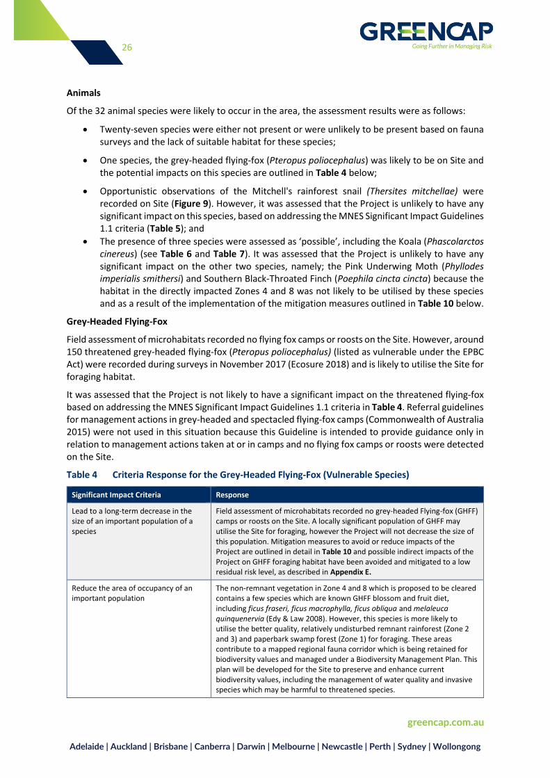
Animals
Of the 32 animal species were likely to occur in the area, the assessment results were as follows:
Twenty-seven species were either not present or were unlikely to be present based on fauna surveys and the lack of suitable habitat for these species;
One species, the grey-headed flying-fox (Pteropus poliocephalus) was likely to be on Site and the potential impacts on this species are outlined in Table 4 below;
Opportunistic observations of the Mitchell's rainforest snail (Thersites mitchellae) were recorded on Site (Figure 9). However, it was assessed that the Project is unlikely to have any significant impact on this species, based on addressing the MNES Significant Impact Guidelines 1.1 criteria (Table 5); and
The presence of three species were assessed as ‘possible’, including the Koala (Phascolarctos cinereus) (see Table 6 and Table 7). It was assessed that the Project is unlikely to have any significant impact on the other two species, namely; the Pink Underwing Moth (Phyllodes imperialis smithersi) and Southern Black-Throated Finch (Poephila cincta cincta) because the habitat in the directly impacted Zones 4 and 8 was not likely to be utilised by these species and as a result of the implementation of the mitigation measures outlined in Table 10 below.
Grey-Headed Flying-Fox
Field assessment of microhabitats recorded no flying fox camps or roosts on the Site. However, around 150 threatened grey-headed flying-fox (Pteropus poliocephalus) (listed as vulnerable under the EPBC Act) were recorded during surveys in November 2017 (Ecosure 2018) and is likely to utilise the Site for foraging habitat.
It was assessed that the Project is not likely to have a significant impact on the threatened flying-fox based on addressing the MNES Significant Impact Guidelines 1.1 criteria in Table 4. Referral guidelines for management actions in grey-headed and spectacled flying-fox camps (Commonwealth of Australia 2015) were not used in this situation because this Guideline is intended to provide guidance only in relation to management actions taken at or in camps and no flying fox camps or roosts were detected on the Site.
Table 4 Criteria Response for the Grey-Headed Flying-Fox (Vulnerable Species)
Significant Impact Criteria Response
Lead to a long-term decrease in the size of an important population of a species
Field assessment of microhabitats recorded no grey-headed Flying-fox (GHFF) camps or roosts on the Site. A locally significant population of GHFF may utilise the Site for foraging, however the Project will not decrease the size of this population. Mitigation measures to avoid or reduce impacts of the Project are outlined in detail in Table 10 and possible indirect impacts of the Project on GHFF foraging habitat have been avoided and mitigated to a low residual risk level, as described in Appendix E.
Reduce the area of occupancy of an important population
The non-remnant vegetation in Zone 4 and 8 which is proposed to be cleared contains a few species which are known GHFF blossom and fruit diet, including ficus fraseri, ficus macrophylla, ficus obliqua and melaleuca quinquenervia (Edy & Law 2008). However, this species is more likely to utilise the better quality, relatively undisturbed remnant rainforest (Zone 2 and 3) and paperbark swamp forest (Zone 1) for foraging. These areas contribute to a mapped regional fauna corridor which is being retained for biodiversity values and managed under a Biodiversity Management Plan. This plan will be developed for the Site to preserve and enhance current biodiversity values, including the management of water quality and invasive species which may be harmful to threatened species.
27
greencap.com.au
Adelaide | Auckland | Brisbane | Canberra | Darwin | Melbourne | Newcastle | Perth | Sydney | Wollongong
Significant Impact Criteria Response
Fragment an existing population into two or more populations
Field assessment of microhabitats recorded no GHFF camps or roosts on the Site, there it is not possible for the Project to fragment an existing population into two or more populations.
Adversely affect the habitat critical to the survival of the species
Although Zone 4 and 8 contain GHFF foraging habitat, the windrows are highly degraded which is not quality foraging habitat and the magnitude of the vegetation clearance is small, with only 0.95 ha proposed to be cleared. The GHFF is a highly mobile species and has been recorded travelling up to 2,000 km within a nine month period (DotE 2014).
The species is known to forage widely within the vicinity of their roost sites, travelling up to 50 km a night in search of food which comprises a mix of nectar and fruit (DotE 2014). The food sources favoured by the species can be spatially and temporally variable and as such the species moves in response to the abundance of forage resources (DECCW 2009). Therefore, the Project is unlikely to adversely affect the habitat critical for the survival of this species.
Disrupt the breeding cycle of an important population
The Project is unlikely to disrupt the breeding cycle of an important population of this species because field assessment of microhabitats recorded no GHFF camps or roosts on the Site.
Modify, remove, destroy, isolate or decrease the availability or quality of habitat to the extent that the species is likely to decline
Zones 4 and 8 currently contribute to habitat connectivity by providing ‘stepping stone’ habitats for threatened species. These existing stepping stone areas will be removed as part of the Project. However, it is not likely that the removal of this small area of low quality habitat will cause the species to decline as adjacent high quality key habitat for this species is being retained and protected for biodiversity values.
The Project includes a helipad on the top of the main building which will result in low level air traffic in the vicinity of the sites. There is a risk that local populations of the threatened grey-headed flying-fox may be flying across the Site in remnant vegetation that is located at the level of the floodplain at the time of aircraft operation. However, the helipad location is considered to be above the flight path altitude of any birds or bats and will therefore not interrupt any local migration or cause death through aircraft strike. At peak operation it is expected that aircraft movements would amount to six movements per week with an estimated flight time of 2 hours per annum and most outbound patient transfers would take place during the day when clinicians are available to make transport decisions. This would therefore avoid aircraft movements in the peak periods of flying fox activity in the hours preceding dusk and dawn. As a consequence, the probability of aircraft strike on flying foxes is negligible.
Result in invasive species that are harmful to a vulnerable species becoming established in the vulnerable species habitat
Existing vegetation in Zones 4 and 8 contains a high percentage of weeds, including high treat exotic weeds. A Biodiversity Management Plan will be developed for the Site to preserve and enhance current biodiversity values, including the management of invasive species which may be harmful to threatened species.
Introduce disease that may cause the species to decline
It is unlikely that the Project will introduce disease that may cause this species to decline. An environmental protection area and buffer zone will be installed to protect the remnant vegetation in the northern section of the Site during construction and a Biodiversity Management Plan will be developed for the Site to preserve and enhance current biodiversity values throughout operation of the Project.
Interfere substantially with the recovery of the species
The Project aims to support recovery of the species by retaining the key habitat of remnant rainforest (Zone 2 and 3) and paperbark swamp forest (Zone 1) that contributes to a mapped regional fauna corridor and to preserve and enhance current biodiversity values, including the management of invasive species which may be harmful to threatened species.
28
greencap.com.au
Adelaide | Auckland | Brisbane | Canberra | Darwin | Melbourne | Newcastle | Perth | Sydney | Wollongong
Mitchell's Rainforest Snail
There was an opportunistic recording of Mitchell’s rainforest snail Thersites mitchellae on 19 November 2018 by Dr Licari and David Milledge. One live specimen was recorded in a portion of Zone 2 and one dead snail shell was recorded outside the Site boundary adjacent to Zone 2 as shown in Figure 9.
A targeted nocturnal spotlight survey for Mitchell’s rainforest snail was conducted on 17-18 December 2018 by Dr Licari and Kyle Spiteri in both Zones 4 and 8. Additional targeted diurnal and nocturnal surveys for the snail concentrating on Zones 4 and 8 were then undertaken on 19-20 December 2018 by Dr Stephanie Clark, a specialist in invertebrate identification. The targeted surveys conducted by Dr Clark included active diurnal habitat searches of logs, rocks, debris and leaf litter on the ground and a nocturnal spotlight survey for active snails. Mitchell’s rainforest snail (one living specimen and three dead snail shells) was found on 20 December 2018 outside of the Site boundary, within the Paperbark Forest adjacent and to the north of Zone 1. In addition, there are known records for Mitchell’s rainforest snail (Bionet database searched, 7 December, 2018) to the east and west of this location. The targeted survey for Mitchell’s rainforest snail undertaken by Dr Clark concluded that the clearance of rainforest vegetation from the proposed development area (Zones 4 and 8) would not significantly impact Mitchell’s rainforest snail habitat (Clark 2019). Targeted fauna survey tracks are mapped in Figure 11. Note that only the GPS data for the Greencap observer has been provided. An equipment malfunction on the 17th December 2018 meant that the full survey extent was not captured, notably the survey in Zone 8.
It was assessed that the Project is not likely to have a significant impact on the critically endangered Mitchell’s rainforest snail based on addressing the MNES Significant Impact Guidelines 1.1 criteria in Table 5.
Table 5 Criteria Response for the Mitchell’s Rainforest Snail (Critically Endangered Species)
Significant Impact Criteria Response
Lead to a long-term decrease in the size of the population
Targeted surveys for Thersites mitchellae (Mitchell's Rainforest Snail) did not detect any evidence of the species within Zones 4 and 8 nor along the edges of Zones 2, 3 and 5 (Clark 2019). It was noted that the vegetation present in Zone 8 is not suitable habitat for Mitchell's rainforest snail, as it is dominated by a line of large pines and otherwise very xeric with very few rainforest plants present along the length of the entire zone. Similarly, the vegetation present in Zone 4 was also not considered suitable habitat for Mitchell's rainforest snail due to a high proportion of exotic species present, relatively narrow patches of vegetation with some rainforest species present however, completely surrounded by cleared fields, resulting in the patches being susceptible to drying due to increased exposure to wind (Clark 2019). As described in the Mitchell's rainforest snail listing advice, though breeding populations of the snail can persist in narrow strips of remnant rainforest such as windrow vegetation in Zone 4 and 8, the long-term viability of populations at such sites is uncertain due to the impact of edge effects factors associated with remnants on land snails which are likely to be adverse. Therefore, the local population of this species is not considered to be dependent on the vegetation proposed for clearance. Possible indirect impacts on known Mitchell’s snail habitat in Zone 1 and 2 and potential habitat in Zone 3 habitat have been avoided and mitigated to a low residual risk level, as described in Appendix E. Furthermore, habitat will be retained and managed to preserve and enhance current biodiversity values, including the management of water quality and invasive species which may be harmful to threatened species, in particular weeds and rats which are one of the known threats to the Mitchell's rainforest snail (Commonwealth of Australia, 2018). Therefore, it is considered that clearing vegetation in Zone 4 and 8 will not lead to a long-term decrease in the population.
29
greencap.com.au
Adelaide | Auckland | Brisbane | Canberra | Darwin | Melbourne | Newcastle | Perth | Sydney | Wollongong
Significant Impact Criteria Response
Reduce the area of occupancy of the species
The targeted survey for Mitchell’s rainforest snail undertaken by Dr Clark concluded that clearance of rainforest vegetation for the Project (Zones 4 and 8) would not significantly impact Mitchell’s rainforest snail habitat (Clark 2019).
Furthermore, there are larger areas of higher quality intact remnant vegetation adjacent to the windrows which constitute key habitat requirements for the Mitchell's rainforest snail, which are a well-developed leaf litter layer and an intact forest canopy. Therefore it is considered that the species would not be dependent on the vegetation proposed for removal when there is more suitable habitat on the Site. Additionally, under the BMP, the Vegetation Management Plan (VMP) incorporates revegetation of the exotic grassland in Zone 9 (0.95 ha) with rainforest species, regeneration and weed management of retained remnant vegetation in the north of the Site. This plan will be linked to the Landscape Masterplan which is focused on the regeneration of retained windrows, as well as native landscape plantings. These proposed measures will further enhance current habitat and potentially provide increased habitat for the Mitchell's rainforest snail.
Fragment an existing population into two or more populations
The removal of 0.95 ha of vegetation in Zones 4 and 8 will not fragment an existing population because it is not a Mitchell's rainforest snail habitat. However, the existing vegetation in the northern portion of the site where the Mitchell’s snail was detected (Zones 1, 2 and 3) contributes to the mapped regional fauna corridor and will be retained, therefore will continue to contribute to connectivity of this part of the habitat. A Biodiversity Management Plan will be developed for the Site to preserve and enhance current biodiversity values for areas of regional fauna corridor vegetation.
Adversely affect the habitat critical to the survival of the species
Known Mitchell’s snail habitat in Zone 1 and 2 and potential habitat in Zone 3 will be retained and managed to preserve and enhance current biodiversity values and managed under a Biodiversity Management Plan (BMP). Therefore, it is considered that clearing vegetation in Zone 4 and 8 will not adversely affect the habitat critical to the survival of the species.
Disrupt the breeding cycle of a population
Known Mitchell’s snail habitat in Zone 1 and 2 and potential habitat in Zone 3 will be retained and managed to preserve and enhance current biodiversity values and managed under a Biodiversity Management Plan (BMP). Therefore, it is considered that clearing vegetation in Zone 4 and 8 will not adversely affect the habitat critical to the survival of the species, therefore clearing 0.95 ha of vegetation in Zone 4 and Zone 8 is not likely to disrupt the breeding cycle of the population.
Modify, remove, destroy, isolate or decrease the availability or quality of habitat to the extent that the species is likely to decline
Known Mitchell’s snail habitat in Zone 1 and 2 and potential habitat in Zone 3 will be retained and managed to preserve and enhance current biodiversity values and managed under a Biodiversity Management Plan (BMP).
Result in invasive species that are harmful to a critically endangered or endangered species becoming established in the endangered or critically endangered species habitat
Known Mitchell’s snail habitat in Zone 1 and 2 and potential habitat in Zone 3 will be retained and managed under a BMP. The BMP will be developed for the Site to preserve and enhance current biodiversity values, including the management of invasive species. Therefore, it is considered that the Project will likely decrease invasive species that are harmful to the critically endangered Mitchell’s rainforest snail.
Introduce disease that may cause the species to decline
It is unlikely that the Project will introduce disease that may cause this species to decline. An environmental protection area and buffer zone will be installed to protect the key habitat in Zones 1, 2 and 3 during construction and a Biodiversity Management Plan will be developed for the Site to preserve and enhance current biodiversity values.
Interfere with the recovery of the species
The Project aims to support and improve the recovery of the species by retaining the key habitat of lowland subtropical rainforest and paperbark swamp vegetation in Zones 1, 2 and 3 and to preserve and enhance current biodiversity values,
30
greencap.com.au
Adelaide | Auckland | Brisbane | Canberra | Darwin | Melbourne | Newcastle | Perth | Sydney | Wollongong
Significant Impact Criteria Response
including the management of invasive species which may be harmful to threatened species.
Koala
It was assessed that the Project is not likely to have a significant impact on the threatened Koala based on addressing the EPBC Act referral guidelines for the vulnerable koala (DOE 2004) criteria in Table 6 and Table 7.
A targeted koala Phascolarctos cinereus scat survey was undertaken in a small 0.2 ha area of preferred koala habitat located in Zone 6 that is located outside of the impact area. This vegetation meets the definition of ‘Secondary (Class A) Habitat’ as defined in the Tweed Coast Comprehensive Koala Plan of Management (CKPoM) and ‘Potential Koala Habitat’ as defined in State Environmental Planning Policy 44 – Koala habitat protection 44.
The scat survey was conducted in broad accordance with the SAT method (Allen & Phillips 2008) on 13 July 2018 by Dr Licari. Scat searches were undertaken in a 1 m buffer area around the base of 30 trees for two person minutes per tree and no koala Phascolarctos cinereus scats were recorded. Whilst undertaking the survey, it was also observed that weedy vegetation and growth of vines would be challenging for koala Phascolarctos cinereus to utilise the trees.
Table 6 Results of Koala Habitat Assessment Tool (DOE 2014)
Attribute Score Appraisal
Koala occurrence 0 A known koala population is not mapped to occur on the proposed site (Phillips et. al., 2011; Figure 1).
Vegetation composition 1 A small area (approximately 0.3 ha) of planted eucalypts with a small number of koala food trees is on the site and will not be directly impacted by the proposed development.
Habitat connectivity 0 The proposed site is not part of a contiguous landscape as defined in the koala habitat assessment tool (DOE 2014).
Key existing threats 1 There is evidence of infrequent or irregular koala mortality from vehicle strike or dog attack (Phillips et. al., 2011).
Recovery value 0 The habitat on the proposed site is unlikely to be important for achieving interim recovery objectives.
Total 2
Table 7 Response to EPBC Act Referral Guidelines for Koala (Vulnerable)
Significant Impact Criteria Response
What does the koala need to survive and recover?
Further loss, fragmentation and degradation of habitat critical to the survival of the koala must be avoided and measures implemented to mitigate and manage impacts that are likely to interfere with the recovery of the koala. Any possible indirect impacts on potential koala habitat in have been avoided and mitigated to a low residual risk level, as described in Appendix E.
Could the impacts of your action occur within the modelled distribution of the koala?
The koala was identified in the PMST as a threatened species (part of the Koala population between the Tweed and Brunswick Rivers east of the Pacific Highway), therefore this triggered an assessment of the likely impact of the proposed action on the species.
In what geographic context are you proposing your action?
The 800 mm per annum rainfall isohyet is used to separate the coastal and inland geographic contexts for koala population distribution. BOM data was
31
greencap.com.au
Adelaide | Auckland | Brisbane | Canberra | Darwin | Melbourne | Newcastle | Perth | Sydney | Wollongong
Significant Impact Criteria Response
obtained from the Kingscliff (Marine Parade) station (Number: 58137). The annual total to Nov this year was 1178.4 mm and 1083.9 mm for 2017.
Therefore, the coastal context criteria are to be used when determining whether habitat is critical to the survival of the koala. Coastal habitat on the Site includes;
– small, isolated patches of native vegetation in rural, urban or peri-urban areas;
– windbreaks and narrow areas of native vegetation along riparian areas or linear infrastructure
– Isolated food and/or shelter trees (i.e. on farm lands, in suburban streetscapes, parks and yards).
Could the impact(s) of your action affect koala habitat?
A small 0.2 ha area of preferred koala habitat is located in Zone 6, which is outside of the Project construction footprint impact area and will be retained and managed for its biodiversity values. Therefore, it is unlikely that the Project will have a significant impact on preferred koala habitat, however, some the koala habitat is likely to be affected by some direct and indirect impacts. These impacts will be avoided or minimised to reduce the risk to a low level and provide some environmental benefits.
Have you surveyed for the koala and koala habitat?
Koalas were surveyed for on the Site and found not present, however a small 0.2 ha area of preferred koala habitat is located in Zone 6, which is outside of the Project construction footprint impact area.
Could your impact area contain habitat critical to the survival of the koala?
The koala habitat assessment was conducted for the proposed site in accordance with the Environment Protection and Biodiversity Conservation Act 1999 (EPBC Act) guidelines and koala habitat assessment tool (DOE 2004) (Table 6). Impact areas that score ≤4 do not contain habitat critical to the survival of the koala, are at low risk of resulting in a significant impact.
Will your action adversely affect habitat critical to the survival of the koala?
The Project will meet the interim recovery objectives for the koala by protecting and conserving large, connected areas of koala habitat, particularly large, connected areas that support koalas and maintaining corridors and connective habitat that allow movement of koalas between large areas of habitat.
The Project will not adversely affect habitat critical to the survival of the koala as there will be no direct impacts on the small 0.2 ha area of preferred koala habitat (not critical habitat) located in Zone 6. It is likely that there will be some impacts form the Project which may affect adjacent habitat which would be used as connective habitat that support koalas to move between larger areas of preferred habitat.
In respect of connectivity, Zones 4 and 8 currently contribute to habitat connectivity by providing ‘stepping stone’ habitats for threatened species. These existing stepping stone areas will be removed as part of the Project. However, this species is more likely to utilise the better quality remnant Paperbark swamp forest (Zone 1 and 2) and the remnant rainforest (Zone 2 and 3) that contribute to a mapped regional fauna corridor which is being retained for biodiversity values and managed under a Biodiversity Management Plan. This plan will be developed for the Site to preserve and enhance current biodiversity values, including the management of hydrogeology, water quality and invasive species which may be harmful to threatened species.
The primary impact on movement of threatened species relates to boundary fencing of the site, noting that species would be able to move around the development unless impeded by a boundary fence. In respect of the current fencing of the site, the only existing fencing in proximity to the site is the wildlife fencing along the Turnock St roadside. The development will not impact this existing fencing. In respect of fencing that will be installed as part of the development, temporary fencing will be
32
greencap.com.au
Adelaide | Auckland | Brisbane | Canberra | Darwin | Melbourne | Newcastle | Perth | Sydney | Wollongong
Significant Impact Criteria Response
installed during the construction phase of the development to facilitate movement of arboreal marsupials such as koala.
This fencing will be installed in accordance with the guidance provided in the Tweed Coast Comprehensive Koala Plan of Management (Tweed Shire Council, 2015). This fencing will be removed at the conclusion of the construction phase of the development.
Impacts of vehicle strikes will be managed through mitigation measures. Traffic will be restricted to the southern portion of the Site where the project footprint is which is approximately 62m from the intact remnant native vegetation. Construction traffic must maintain low vehicle speeds and operators shall take care and be aware of any wildlife that may be in the area. Should wildlife enter the construction area during operation of
the Project wildlife protection and traffic calming measures will mitigate the risk of vehicle strike impact on this species.
Could your action interfere substantially with the recovery of the koala?
Existing vegetation in Zones 4 and 8 contains a high percentage of weeds, including high treat exotic weeds. A Biodiversity Management Plan will be developed for the Site to preserve and enhance current biodiversity values, including the management of invasive species which may be harmful to threatened species.
It is unlikely that the Project will introduce disease that may cause this species to decline. An environmental protection area and buffer zone will be installed to protect the remnant vegetation in the northern section of the Site during construction and a Biodiversity Management Plan will be developed for the Site to preserve and enhance current biodiversity values throughout operation of the Project.
The Project aims to support recovery of the species by retaining the key habitat of remnant rainforest (Zone 2 and 3) and paperbark swamp forest (Zone 1) that contributes to a mapped regional fauna corridor and to preserve and enhance current biodiversity values, including the management of invasive species which may be harmful to threatened species.
Could your action require a referral to the Minister for significant impacts on the koala?
Impact areas that score ≤4 do not contain habitat critical to the survival of the koala, are at low risk of resulting in a significant impact.
By avoiding direct and indirect impacts and implementing mitigation to the Project will reduce impacts on the koala to a level which is not significant.
Pink Underwing Moth
It was assessed that the Project is not likely to have a significant impact on the Pink Underwing Moth (Phyllodes imperialis smithersi) based on addressing the MNES Significant Impact Guidelines 1.1 criteria in Table 8.
Table 8 Criteria Response for the Pink Underwing Moth (Endangered Species)
Significant Impact Criteria Response
Lead to a long-term decrease in the size of the population
The targeted flora survey for Zones 4 and 8 recorded the host plant Carronia multisepalea as absent. Furthermore, field assessment of Zones 4 and 8 suggested that these linear windrows are subject to high levels of light and are therefore not suitable microhabitats for breeding in Zones 4 and 8.
Potential breeding habitat for on the Pink Underwing Moth (Phyllodes imperialis smithersi) is restricted to subtropical rainforest with low light conditions below about 600 m elevation where the caterpillar's host plant Carronia multisepalea (a native rainforest vine) is found to occur (OEH 2018d). Any possible indirect impacts on potential habitat in Zone 2 and 3 have been avoided and mitigated to a low residual risk level, as described in Appendix E.
33
greencap.com.au
Adelaide | Auckland | Brisbane | Canberra | Darwin | Melbourne | Newcastle | Perth | Sydney | Wollongong
Significant Impact Criteria Response
Additionally, potential breeding habitat in subtropical rainforest in Zone 2 and 3 will be retained and managed to preserve and enhance current biodiversity values and managed under a Biodiversity Management Plan (BMP). Therefore, it is considered that clearing vegetation in Zone 4 and 8 will not lead to a long-term decrease in the size of the Pink Underwing Moth population.
Reduce the area of occupancy of the species
Field assessment of areas of vegetation to be cleared (Zones 4 and 8) suggested that these linear windrows are subject to high levels of light and are therefore not suitable microhabitats for Pink Underwing Moth breeding in Zones 4 and 8 (Greencap 2019).
Fragment an existing population into two or more populations
The removal of 0.95 ha of vegetation in Zones 4 and 8 will not fragment an existing population because it is not considered to be Pink Underwing Moth habitat. However, potential breeding habitat in subtropical rainforest in Zone 2 and 3 contributes to the mapped regional fauna corridor and will be retained, therefore will continue to contribute to connectivity of this part of the habitat. A Biodiversity Management Plan (BMP) will be developed for the Site to preserve and enhance current biodiversity values for areas of regional fauna corridor vegetation.
Adversely affect the habitat critical to the survival of the species
The removal of 0.95 ha of vegetation in Zones 4 and 8 will not adversely affect the habitat critical to the survival of the species because it is not considered to be Pink Underwing Moth breeding habitat. However, potential breeding habitat in subtropical rainforest in Zone 2 and 3 will be retained and managed to preserve and enhance current biodiversity values under a Biodiversity Management Plan (BMP). Therefore, it is considered that clearing vegetation in Zone 4 and 8 will not adversely affect the habitat critical to the survival of the species.
Disrupt the breeding cycle of a population
The targeted flora survey for Zones 4 and 8 recorded the host plant Carronia multisepalea as absent. Furthermore, field assessment of Zones 4 and 8 suggested that these linear windrows are subject to high levels of light and are therefore not suitable microhabitats for Pink Underwing Moth breeding. Potential breeding habitat in subtropical rainforest in Zone 2 and 3 will be retained and managed to preserve and enhance current biodiversity values under a Biodiversity Management Plan (BMP). Therefore, the removal of 0.95 ha of vegetation in Zones 4 and 8 is not likely to disrupt the breeding cycle of a population.
Modify, remove, destroy, isolate or decrease the availability or quality of habitat to the extent that the species is likely to decline
Field assessment of microhabitats on the Site found that it is substantially degraded such that the species is unlikely to utilise the vegetation from the proposed development area (Zones 4 and 8). Therefore, the Project will not decrease the availability or quality of habitat to the extent that the species is likely to decline. Potential breeding habitat in subtropical rainforest in Zone 2 and 3 will be retained and managed to preserve and enhance current biodiversity values under a Biodiversity Management Plan (BMP).
Result in invasive species that are harmful to a critically endangered or endangered species becoming established in the endangered or critically endangered species habitat
Potential breeding habitat in subtropical rainforest in Zone 1 and 2 will be retained and managed to preserve and enhance current biodiversity values and managed under a Biodiversity Management Plan (BMP). The BMP will include the management of invasive species. Therefore, it is considered that the Project will likely decrease invasive species that are harmful to the endangered Pink Underwing Moth.
Introduce disease that may cause the species to decline
It is unlikely that the Project will introduce disease that may cause this species to decline. An environmental protection area and buffer zone will be installed to
protect potential key habitat in Zones 2 and 3 during construction and a BMP will be developed for the Site to preserve and enhance current biodiversity values.
Interfere with the recovery of the species
The Project aims to support and improve the recovery of the species by retaining the potential key habitat in Zones 2 and 3 and to preserve and enhance current biodiversity values, including the management of invasive species which may be harmful to threatened species.
34
greencap.com.au
Adelaide | Auckland | Brisbane | Canberra | Darwin | Melbourne | Newcastle | Perth | Sydney | Wollongong
Southern Black-Throated Finch
It was assessed that the Project is not likely to have a significant impact on the Southern Black-Throated Finch based on addressing the MNES Significant Impact Guidelines 1.1 criteria in Table 9.
Table 9 Criteria Response for the Southern Black-Throated Finch (Endangered Species)
Significant Impact Criteria Response
Lead to a long-term decrease in the size of the population
Vegetation from the proposed development area (Zones 4 and 8) constitute substantially degraded derived regenerating Subtropical Rainforest which is not preferred habitat for the Southern Black-Throated Finch. Additionally, any possible indirect impacts on potential habitat in Zone 1, 6 and 7 have been avoided and mitigated to a low residual risk level, as described in Appendix E, and will be managed to preserve and enhance current biodiversity values under a BMP. Therefore, the removal of 0.95 ha of vegetation in Zones 4 and 8 will not lead to a long-term decrease in the size of the Southern Black-Throated Finch population.
Reduce the area of occupancy of the species
Vegetation from the proposed development area (Zones 4 and 8) constitute substantially degraded derived regenerating Subtropical Rainforest which is not preferred habitat for the Southern Black-Throated Finch. Therefore, the removal of 0.95 ha of vegetation in Zones 4 and 8 will Reduce the area of occupancy of the species the Southern Black-Throated Finch. However, potential habitat in paperbark swamp forest in Zone 1 and flooded gum forest in Zone 6 and 7 will be retained and managed to preserve and enhance current biodiversity values under a BMP.
Fragment an existing population into two or more populations
Field assessment of microhabitats on the Site found that it is substantially degraded such that the species is unlikely to utilise the vegetation from the proposed development area (Zones 4 and 8). Therefore, the removal of 0.95 ha of vegetation in Zones 4 and 8 will not fragment an existing population. However, potential habitat in paperbark swamp forest in Zone 1 and flooded gum forest in Zone 6 and 7 will be retained and managed to preserve and enhance current biodiversity values under a BMP.
Adversely affect the habitat critical to the survival of the species
The removal of 0.95 ha of vegetation in Zones 4 and 8 will not adversely affect the habitat critical to the survival of the species because it is not considered critical or high value habitat for the endangered Southern Black-Throated Finch. However, potential habitat in paperbark swamp forest in Zone 1 and flooded gum forest in Zone 6 and 7 will be retained and managed to preserve and enhance current biodiversity values under a BMP.
Disrupt the breeding cycle of a population
Field assessment of microhabitats on the Site found that it is substantially degraded such that the species is unlikely to utilise the vegetation from the proposed development area (Zones 4 and 8). Potential habitat in paperbark swamp forest in Zone 1 and flooded gum forest in Zone 6 and 7 will be retained and managed to preserve and enhance current biodiversity values under a Biodiversity Management Plan (BMP). Removal of 0.95 ha of vegetation in Zones 4 and 8 will not disrupt the breeding cycle of a population.
Modify, remove, destroy, isolate or decrease the availability or quality of habitat to the extent that the species is likely to decline
Field assessment of microhabitats on the Site found that it is substantially degraded such that the species is unlikely to utilise the vegetation from the proposed development area (Zones 4 and 8). Furthermore, Zones 4 and 8 constitute derived regenerating Subtropical Rainforest which is not preferred habitat for the Southern Black-Throated Finch. Therefore, the Project will not decrease the availability or quality of habitat to the extent that the species is likely to decline. Potential habitat in paperbark swamp forest in Zone 1 and flooded gum forest in Zone 6 and 7 will be retained and managed to preserve and enhance current biodiversity values under a BMP.
35
greencap.com.au
Adelaide | Auckland | Brisbane | Canberra | Darwin | Melbourne | Newcastle | Perth | Sydney | Wollongong
Significant Impact Criteria Response
Result in invasive species that are harmful to a critically endangered or endangered species becoming established in the endangered or critically endangered species habitat
Potential habitat in paperbark swamp forest in Zone 1 and flooded gum forest in Zone 6 and 7 will be retained and managed to preserve and enhance current biodiversity values and managed under a BMP. The BMP will include the management of invasive species.
Therefore, it is considered that the Project will likely decrease invasive species that are harmful to the endangered Southern Black-Throated Finch.
Introduce disease that may cause the species to decline
It is unlikely that the Project will introduce disease that may cause this species to decline. An environmental protection area and buffer zone will be installed to protect potential key habitat in paperbark swamp forest in Zone 1 and flooded gum forest in Zone 6 and 7 during construction and a BMP will be developed for the Site to preserve and enhance current biodiversity values.
Interfere with the recovery of the species
The Project aims to support and improve the recovery of the species by retaining the potential key habitat in paperbark swamp forest in Zone 1 and flooded gum forest in Zone 6 and 7and to preserve and enhance current biodiversity values, including the management of invasive species which may be harmful to threatened species.
Other species
Although there will potentially be some indirect impacts, it was assessed that the Project is not likely to have a significant impact on other species which are unlikely to occur at the Site, based on addressing the MNES Significant Impact Guidelines 1.1 criteria for vulnerable, endangered or critically endangered threatened species (Appendix A). Furthermore, fauna surveys undertaken as part of the BAM assessment did not record other species likely to occur at the Site (Greencap 2019). The survey effort for fauna is shown in Figure 11. Note that only the GPS data for the Greencap observer has been provided. An equipment malfunction on the 17th December 2018 meant that the full survey extent was not captured, notably the survey in Zone 8.
In addition to the Significant Impact Guidelines, the Commonwealth has also released specific guidance for some EPBC Act listed species, therefore where available specific guidance were referred to, for particular species that are relevant to the Site.
5.2 Direct Impacts
Due to the successful application of the avoid and minimise strategy undertaken as part of the BAM assessment and outlined in Section 5.4 and Table 10 below, the Project will only directly impact 0.95 ha of planted or self-sown windrow vegetation in Zone 4 and 8 (Greencap 2019). The vegetation to be retained and removed on Site and the development footprint is outlined in Figure 12.
5.3 Indirect and Offsite Impacts
A total of approximately 7.45 ha of native vegetation on Site may be indirectly impacted by the Project. Vegetation condition is moderate, low and derived and vegetation integrity will not decrease. Indirect impacts are addressed in Appendix E and generally relate to:
Noise and vibration;
Light spill and visual amenity;
Dust;
Bushfire and changing fire regimes;
Damage or removal of retained native vegetation; and
Weeds.
36
greencap.com.au
Adelaide | Auckland | Brisbane | Canberra | Darwin | Melbourne | Newcastle | Perth | Sydney | Wollongong
As a result of the risk assessment of indirect impacts, it was identified that the residual risk following the application of mitigation measures was very low.
555400 555600 555800 55600068
7320
0
6873
200
6873
400
6873
400
6873
600
6873
600
6873
800
6873
800
6874
000
6874
000
Sca le (@A4):
Author: M. N unn
1:4,000Clie nt: C107778
Checke d : D. Lica riDa te : 1/02/2019
Job #: J156455 ± 0 50 100m
No warranty is given in relation to the data (including accuracy, reliability, completeness or suitability) and accept no liability (including without limitation, liability in negligence) for any loss, damage or costs (includingconsequential damage) relating to any use of or reliance upon the data. Data must not be used for direct marketing or be used in breach of privacy laws.
Figure10
Coord ina te Syste m : GDA 1994 MGA Z one 56
Doc Path: R:\_Projects\C107778_Health Infrastructure\J156455_Tweed Valley Hospital\3. Job Folder\GIS\J156455_Tweed_Valley_Hospital\MNES\mxd\J156455_MNES_F10_survey_effort_flora_190125.mxd
Site Bound a ryTa rg e te d Flora Survey - 16thAug ust 2018Ta rg e te d Flora Survey - 3rdSe pte m be r 2018
Vegetation Zone (PCT)Z one 1 (1064 - Pa pe rba rkswa m p fore st of the coa sta llowla nd s)Z one 2 (1302 - WhiteBooyong - Fig subtropica lra infore st)Z one 3 (1302 - WhiteBooyong - Fig subtropica lra infore st)
Z one 4 (1302 - WhiteBooyong - Fig subtropica lra infore st)Z one 5 (1569 - Flood e d Gum– Brush Box – Ta llowwoodm e sic ta ll ope n fore st)Z one 6 (1569 - Flood e d Gum– Brush Box – Ta llowwoodm e sic ta ll ope n fore st)Z one 7 (1235 - Swa m p Oa kswa m p fore st of the coa sta llowla nd s)Z one 8 (1302 - WhiteBooyong - Fig subtropica lra infore st)Z one 9 (n/a - ExoticVe g e ta tion)
Twe e d Va lle y Hospita l MN ES R e port771 Cud g e n Roa dCud g e n N SW
Trapline 2Trapline 3
Trapli
ne 4
Trapline 1
555400 555600 555800 55600068
7320
0
6873
200
6873
400
6873
400
6873
600
6873
600
6873
800
6873
800
6874
000
6874
000
Sca le (@A4):
Author: M. N unn
1:4,000Clie nt: C107778
Checke d : D. Lica riDa te : 1/02/2019
Job #: J156455 ± 0 50 100m
No warranty is given in relation to the data (including accuracy, reliability, completeness or suitability) and accept no liability (including without limitation, liability in negligence) for any loss, damage or costs (includingconsequential damage) relating to any use of or reliance upon the data. Data must not be used for direct marketing or be used in breach of privacy laws.
18th Dece m be r 2018Loca tion of Sna il Specim e n Find s(non-liste d spe cie s) During Survey
Vegetation Zone (PCT)Z one 1 (1064 - Pa pe rba rk swa m pfore st of the coa sta l lowla nd s)Z one 2 (1302 - White Booyong -Fig subtropica l ra infore st)Z one 3 (1302 - White Booyong -Fig subtropica l ra infore st)Z one 4 (1302 - White Booyong -Fig subtropica l ra infore st)
Z one 5 (1569 - Flood e d Gum –Brush Box – Ta llowwood m e sic ta llope n fore st)Z one 6 (1569 - Flood e d Gum –Brush Box – Ta llowwood m e sic ta llope n fore st)Z one 7 (1235 - Swa m p Oa kswa m p fore st of the coa sta llowla nd s)Z one 8 (1302 - White Booyong -Fig subtropica l ra infore st)Z one 9 (n/a - Exotic Ve g e ta tion)
Coord ina te Syste m : GDA 1994 MGA Z one 56
Doc Path: R:\_Projects\C107778_Health Infrastructure\J156455_Tweed Valley Hospital\3. Job Folder\GIS\J156455_Tweed_Valley_Hospital\MNES\mxd\J156455_MNES_F11_fauna_survey_effort_190125.mxd
No warranty is given in relation to the data (including accuracy, reliability, completeness or suitability) and accept no liability (including without limitation, liability in negligence) for any loss, damage or costs (includingconsequential damage) relating to any use of or reliance upon the data. Data must not be used for direct marketing or be used in breach of privacy laws.
Figure12
Site Boundary
Indicative Location ofVegetationRemoval/Retention
Vegetation to beRemoved
Vegetation to beRetained
Coordinate System: GDA 1994 MGA Zone 56
Doc Path: R:\_Projects\C107778_Health Infrastructure\J156455_Tweed Valley Hospital\3. Job Folder\GIS\J156455_Tweed_Valley_Hospital\MNES\mxd\J156455_MNES_F12_direct_impacts_190125.mxd
Adelaide | Auckland | Brisbane | Canberra | Darwin | Melbourne | Newcastle | Perth | Sydney | Wollongong
5.4 Key Measures to Avoid, Mitigate and Reduce Direct and Indirect Impacts
Without the implementation of appropriate mitigation measures, the Project could potentially result in a number of direct, indirect or offsite impacts on MNES species. However, a comprehensive set of measures will be put in place to avoid, mitigate or reduce these impacts to the fullest extent possible. These measures are detailed in Table 10 below. Mitigation measures (including timing, frequency and responsibility) proposed to mitigate or manage the direct and indirect impacts during both the construction and operation phases of the Project are outlined in Appendix E. These mitigation measures involve several plans and sub plans, including adaptive management for impacts on biodiversity that are uncertain, which are proposed to be deployed for the Project construction and operational phases, including:
Biodiversity Management Plan;
o Vegetation Management Plan;
o Fauna Management Plan;
o Water Quality Management Plan;
Landscape Masterplan;
Construction Environmental Management Plan;
o Soil and Water Management Plan;
o Traffic Control Plan; and
o Access and Movement Plan.
Risk of any residual impacts likely to remain after the mitigation measures have been applied is evaluated in Appendix E. Risk assessment criteria for likelihood, consequence and risk level are provided in Appendix F. In summary, the impacts of the Project have been avoided and minimised by using the following principles to situate the development footprint in areas:
Where there are no biodiversity values: Those smaller parts of the Project Site which represent areas of higher biodiversity value, for example where remnant vegetation has been retained, were identified and removed from the Project’s development footprint. The only areas of native vegetation to be cleared are parts of the windrows in the southern section of the Project Site;
Where the existing native vegetation or threatened species habitat is in poor condition: The Project Site was selected because it is currently operated as an agricultural enterprise, and therefore the majority of remnant vegetation has already been cleared. Apart from a bund that has been constructed along the western boundary of the Site which adjoins an open drain, the working farm had no stormwater management system in place. This contributed to sediment-laden water discharging into the wetland and contributing to the reduction in water quality. For instance, cultivated fields were ploughed across topographic contours enabling sediment-laden stormwater to flow downhill through ploughed furrows and observation of the landholder at work suggested the frequent use of pesticides. Moreover, a Council owned drain carrying untreated stormwater flows from Turnock Street discharges directly into the receiving catchment.
The stormwater management system for the project has been designed to mimic natural flows and thereby minimise indirect impacts on the floodplain habitat in the receiving catchment and wetland located to the north of the Site. The stormwater management system incorporating, rain gardens, swales, enviropods and bio-retention basins. Ultimately the bulk of the stormwater will end up in an extended detention basin to settle and then discharge to the receiving catchment in a controlled manner.
41
greencap.com.au
Adelaide | Auckland | Brisbane | Canberra | Darwin | Melbourne | Newcastle | Perth | Sydney | Wollongong
Avoiding habitat for threatened species or ecological communities that are either critically endangered or endangered; and
Maintaining connectivity, enabling movement of species and genetic material between areas of adjacent or nearby habitat: Those areas of the Project Site which are critical for connectivity, such as the northern section of the Site which falls within a mapped fauna corridor, will be maintained for their contribution to biodiversity values.
On this basis, the Project footprint has been located in an area that avoids or minimises direct impacting MNES threatened species, migratory species and TECs.
42
greencap.com.au
Adelaide | Auckland | Brisbane | Canberra | Darwin | Melbourne | Newcastle | Perth | Sydney | Wollongong
Table 10 Avoiding and Minimising Impacts on Vegetation, Habitat and Biodiversity Values
Point Approach Mitigation Description
Locating the project to avoid and minimise impacts on native vegetation
1 Locating a project in areas where there are no biodiversity values
The Project has been located on those portions of the site that are cleared land where there are no biodiversity values.
A two-phase site selection process was undertaken by Health Infrastructure to assess the suitability of a range of greenfield and brownfield sites for the development of the new hospital where more than 50 sites were assessed. Assessment of impacts on biodiversity was an important component of this due diligence assessment.
Following the site selection process, due diligence assessments, public consultation, and input from the Health Infrastructure Site Selection Committee, the Site was confirmed and publicly announced in June 2018. An ecological constraints analysis was then undertaken for the chosen Site (Greencap 2018).
The ecological constraints analysis recommended that the areas of the Site that have been identified with high ecological constraint are considered to be areas where development should be avoided and afforded an appropriate level of protection. Moreover, consideration should be given to undertake ecological restoration and management activity that improves the quality of remnant habitat on the Site (Greencap 2018).
No Areas of Outstanding Biodiversity Value or areas of geological significance are located on the Site.
2 Locating the project in areas where the native vegetation is in the poorest condition (i.e. low VI score)
The Project has been located in an area where the project footprint will only impact areas of native vegetation that are in the poorest condition where the potential for impacting threatened species is low.
The northern section of the Site is located on the Tweed River floodplain and is part of an important local wetland (mapped under State Environmental Planning Policy (Coastal Management) 2018; Coastal Management SEPP). This section of the site is also mapped regional fauna corridor. The entire northern section of the Site will be retained and maintained for its biodiversity values.
The project development will occur in the southern section of the Site which is currently a working farm under cultivation. Apart from the windrows planted along the Site boundary, most of the southern section of the Site has been cleared of native vegetation.
All areas of remnant native vegetation on Site (Zones 1, 2 and 3) and planted windrow vegetation at the Site (Zones 5, 6 and 7) will be retained and managed in accordance with the vegetation management performance criteria to be set out in an approved Biodiversity Management Plan in order to preserve and enhance current biodiversity values.
43
greencap.com.au
Adelaide | Auckland | Brisbane | Canberra | Darwin | Melbourne | Newcastle | Perth | Sydney | Wollongong
Point Approach Mitigation Description
Some areas of native vegetation in windrows (Zones 4 and 8) will be cleared, with the remaining vegetation in these windrows regenerated to remove woody weeds and regenerated with native species and woody weeds that are classified as High Threat Exotics in accordance with a Landscape Masterplan. Relevant components of this Landscape Masterplan will be incorporated into the approved Biodiversity Management Plan.
The current VI for Zone 4 falls below the assessment threshold for PCTs that are representative of an Endangered Ecological Communities (i.e. VI ≤ 15). The current VI for Zone 8 is very low (16.8) is very low. .
Based on the above results, there will be no decrease in the overall condition of the potential TECs identified on Site remaining in the IBRA sub region due to impact from the Projects construction or operation.
3 Locating the project in areas that avoid habitat for species that have a high biodiversity risk rating and vegetation that is a CEEC or an EEC, indicated by the biodiversity risk weighting for the species
The Project has been located in an area that avoids impacting on threatened species and vegetation in high threat categories (i.e. Endangered Ecological Communities).
There are no direct impacts on associated areas of potential habitat which are likely to contribute significantly to the risk of extinction of any threatened species.
There are no hollow bearing trees located in areas to be cleared (Zones 4 and 8).
A detailed site selection process and due diligence assessment as outlined above was undertaken to assess any ecological constraints present at the chosen Site. It was assessed that the Stage 1 project design and the location of the projects ancillary features will minimise direct impacts on threatened species and vegetation in high threat categories.
4 Locating the project such that connectivity enabling movement of species and genetic material between areas of adjacent or nearby habitat is maintained
The Project does not impact on regional connectivity values
The project will have negligible impact on connectivity values surrounding the development Site. The Site is located within mapped regional fauna corridor; however, the development will not directly impact any areas of intact remnant vegetation or areas of habitat connectivity.
Sections of self-sown windrow vegetation (Zones 4 and 8) will be cleared for the development (1 ha). These windrows may offer marginal foraging habitat and stepping-stone connectivity for some threatened species. However, the fauna species which may potentially utilise these windrows are highly mobile.
Furthermore, regeneration and revegetation of areas detailed in the Landscape Masterplan Report (TURF 2018) will enhance connectivity within the site when compared to the existing land use.
Under the BMP, the Vegetation Management Plan (VMP) incorporates revegetation of the exotic grassland in Zone 9 (0.95 ha) with rainforest
44
greencap.com.au
Adelaide | Auckland | Brisbane | Canberra | Darwin | Melbourne | Newcastle | Perth | Sydney | Wollongong
Point Approach Mitigation Description
species, regeneration and weed management of retained remnant vegetation in the north of the Site. This plan will be linked to the Landscape Masterplan which is focused on the regeneration of retained windrows, as well as native landscape plantings. These proposed measures will further enhance current habitat and potentially provide increased habitat for the critically endangered Mitchell's rainforest snail.
Designing a project to avoid and minimise impacts on native vegetation and habitat
5 Reducing the clearing footprint of the project
The clearing footprint will be reduced to a minimum in vegetation zones with low vegetation integrity and no remnant native vegetation will be cleared
Incorporating a multi-level building design for the main hospital building has avoided impacts on habitat, by allowing for a smaller site area to be considered during the site selection process.
All areas of the Site that have been identified with high ecological constraint are located in areas where development will be avoided. No remnant native vegetation will be cleared.
6 Locating ancillary facilities in areas where there are no biodiversity values
Ancillary facilities will be located on land that has been cleared for cultivation
Ancillary facilities will be located occur in the southern section of the Site which is currently a working farm under cultivation. Apart from derived vegetation located in self-sown and planted windrows, most of the southern section of the Site has been previously cleared of native vegetation.
7 Locating ancillary facilities in areas where the native vegetation or threatened species habitat is in the poorest condition
Ancillary facilities will be located on land where native vegetation has low VI
8 Locating ancillary facilities in areas that avoid habitat for species that have a high biodiversity risk rating and vegetation that is a CEEC or an EEC, indicated by the biodiversity risk weighting for the species
The proposed ancillary facilities have been located in an area that avoids impacting on threatened species and vegetation in high threat categories (i.e. EECs)
See point 5.
9 Providing structures to enable species and genetic material to move across barriers or hostile gaps
Where possible structures will be provided to enable connectivity for species
It is recommended that a wildlife crossing is established to the north-east of the Site where the Turnock Street roadway passes through the remnant vegetation. Fauna management guidelines will be detailed in the Biodiversity Management Plan.
45
greencap.com.au
Adelaide | Auckland | Brisbane | Canberra | Darwin | Melbourne | Newcastle | Perth | Sydney | Wollongong
Point Approach Mitigation Description
10 Making provision for the demarcation, ecological restoration, rehabilitation and/or ongoing maintenance of retained native vegetation habitat on the development site
All remnant native vegetation outside of the development footprint will be protected and maintained
All areas of intact remnant native vegetation on Site and remaining areas of planted or self-sown windrow vegetation at the Site will be retained and managed in accordance with the vegetation management performance criteria to be set out in the Biodiversity Management Plan in order to preserve and enhance current biodiversity values.
Avoiding and minimising prescribed biodiversity impacts during project planning
1 Impacts of development on the habitat of threatened species or ecological communities associated with karst, caves, crevices, cliffs and other geological features of significance;
These habitat features have not been identified as present on the Site, impacts are avoided.
While not specific to a particular habitat feature, habitat constraints were considered as part of the site selection process* during project planning, with a preference for sites where known habitat of threatened species or ecological communities could be avoided, and where impacts could not be avoided, where they could be minimised.
2 Impacts of development on the habitat of threatened species or ecological communities associated with rocks.
As part of the current use of the Site, rocks have been moved to form walled areas in the windrows
While not specific to a particular habitat feature, habitat constraints were considered as part of the site selection process during project planning, with a preference for sites where known habitat of threatened species or ecological communities could be avoided, and where impacts could not be avoided, where they could be minimised.
3 Impacts of development on the habitat of threatened species or ecological communities associated with human made structures
Human made structures present on the development site including buildings, stonewalls, and dams have not been identified as habitat for threatened species or ecological communities
NA
4 Impacts of development on the habitat of threatened species or ecological communities associated with non-native vegetation.
Impacts will be minimised by retaining some windrow vegetation
Sections of self-sown windrow vegetation (Zones 4 and 8) containing non-natives will be cleared for the development (1 ha). These windrows may offer marginal foraging habitat and stepping-stone connectivity for some threatened species. However, the fauna species which may potentially utilise these windrows are highly mobile.
46
greencap.com.au
Adelaide | Auckland | Brisbane | Canberra | Darwin | Melbourne | Newcastle | Perth | Sydney | Wollongong
Point Approach Mitigation Description
5 Impacts of development on connectivity of different areas of habitat of threatened species that facilitates the movement of those species across their range.
Site selection processes sought to avoid areas of habitat connectivity of threatened species and the potential to cause habitat fragmentation.
Location of the envelope of surface works will avoid direct impacts on connectivity of different areas of habitat.
Habitat connectivity and the potential for fragmentation were included in the site selection criteria.
The location of the development area on the site has been selected to avoid and minimise clearing of habitat areas of threatened species, including those that facilitate the movement of those species across their range.
6 Impacts of development on movement of threatened species that maintains their life cycle.
Locating the project development area away from threatened species habitat areas and establishing a vegetated buffer will minimise impacts on the movement of threatened species that maintains their life cycle.
A ‘post and bridge’ system will be installed with the temporary boundary fencing during construction to facilitate movement of arboreal fauna.
Permanent boundary fencing will not be installed.
The location of the development area on the site has been selected to avoid and minimise clearing of habitat areas of threatened species, including those that facilitate the movement that maintains their life cycle.
For construction of the development, the temporary boundary will be fitted with a ‘post and bridge’ system to facilitate movement of koala
For operation of the development, a boundary fence will not be installed, thereby facilitating movement of threatened species.
7 Impacts of development on water quality, water bodies and hydrological processes that sustain threatened species and threatened ecological communities (including from subsidence or upsidence resulting from underground mining)
Selection of a site that avoids the direct impacts to water bodies or water quality.
Avoiding locating the development footprint in areas of the site that directly impact water bodies, or significantly interfere with hydrological processes.
Water quality impacts will be avoided during construction through the use of erosion and sediment control measures.
Impacts to water quality and hydrological processes during operation will be minimised through the use of WSUD measures that maintain flows to
Direct impacts to water quality, water bodies and hydrological processes that sustain threatened species and ecological communities were avoided through the site selection process by including constraints on sites that would require the development footprint to impede on water bodies.
The location of the development footprint on the Site seeks to minimise interference with hydrological flows through the wetlands including contributions from groundwater. Other than what may be required for piling, subsurface excavations will be at a shallower depth than measured groundwater depths on the site. Piles will be between 800 mm and 1200 mm in diameter and will typically be spaced 8.4 m apart, except under lift and/or stairwell cores where they will be not less than 2m apart. As the piles are not continuous, it is not anticipated that they will create a barrier to any shallow or perched groundwater flow that currently occurs within the development footprint, minimising the potential for the development to impact groundwater contributions to baseflow in the wetlands.
47
greencap.com.au
Adelaide | Auckland | Brisbane | Canberra | Darwin | Melbourne | Newcastle | Perth | Sydney | Wollongong
Point Approach Mitigation Description
the wetlands and maintain or improve water quality.
Water quality impacts to the wetlands will be avoided by employing effective and properly designed erosion and sediment control measures at prior to the commencement of other construction activities, including adequately sized retention basins that are appropriately monitored and managed. The stormwater management system for operation of the Project will be designed in accordance with the locally appropriate standard (TSC 2016), and it is expected that operation of the Project will result in a net improvement in the quality of stormwater that is discharged from the Site.
The water quality strategy for the site will incorporate swales, enviropods, bioretention basins and extended detention basins. The roof runoff will be directed into the bioretention basin by a pit and pipe system while hardstand runoff will be first treated by enviropods, and then either swales that discharge to the bioretention system or directly into the bioretention systems. Ultimately the bulk of the stormwater will end up in an extended detention basin where it will settle and discharge to the receiving waters in a controlled manner. It is noted, upon the advice of the accredited Bushfire Consultant for the project, that permanent bioretention basins are an appropriate landuse within an APZ provided that the installation of such structures does not increase the fuel load within the APZ, for example, through inappropriate landscaping, and as long as it does not present an impediment to regular maintenance of the APZ. This advice will be factored into the water quality strategy for the site.
8 Impacts of wind turbine strikes on protected animals
No wind turbines are planned as part of this project
N/A
9 Impacts of vehicle strikes on threatened species or animals that are part of a TEC
Impacts will be minimised by locating the main site entrances on alternative routes than those adjacent to TECs
Where possible impacts will be minimised by providing structures to enable connectivity for species that prevent or avoid crossing roads.
Main site entrances provided off Cudgen Road
It is recommended that a wildlife crossing is established to the north-east of the Site where the Turnock Street roadway passes through the remnant vegetation. Fauna management guidelines will be detailed in the Biodiversity Management Plan.
* As part of the site selection process, a comprehensive list of constraints from a variety of disciplines were assessed for each proposed site to ensure project needs could be met, and to short list sites for further evaluation to determine the most suitable site overall. Criteria used in this process included:
48
greencap.com.au
Adelaide | Auckland | Brisbane | Canberra | Darwin | Melbourne | Newcastle | Perth | Sydney | Wollongong
6. CONCLUSIONS
The Project will directly impact Zones 4 and 8 as a result of clearing of 0.95 ha of vegetation in these areas. However, it is important to note that this vegetation type is in low condition and does not meet all of the condition thresholds for a TEC to be considered a MNES as defined under the EPBC Act.
The implementation of a comprehensive set of mitigation measures will allow for the management and mitigation of any potential indirect and offsite impacts on MNES ecological communities, migratory species and threatened species.
Native vegetation remaining on Site will be retained and managed to enhance and protect the biodiversity values.
49
greencap.com.au
Adelaide | Auckland | Brisbane | Canberra | Darwin | Melbourne | Newcastle | Perth | Sydney | Wollongong
7. REFERENCES
Commonwealth of Australia (2013). Matters of National Environmental Significance – Significant Impact Guidelines 1.1 Environmental Protection and Biodiversity Conservation Act 1999 Department of Environment, Climate Change and Water NSW (2009). Draft National Recovery Plan for the Grey-headed Flying-fox Pteropus poliocephalus. Prepared by Dr Peggy Eby. Department of Environment, Climate Change and Water NSW, Sydney. http://www.environment.nsw.gov.au/resources/threatenedspecies/08214dnrpflyingfox.pdf Department of the Environment (2014). Pteropus poliocephalus in Species Profile and Threats Database. Department of the Environment, Canberra. http://www.environment.gov.au/cgi-bin/sprat/public/publicspecies.pl?taxon_id=186 Department of the Environment and Energy (2018). Conservation advice (incorporating listing advice) for the Coastal Swamp Oak (Casuarina glauca) Forest of New South Wales and South East Queensland ecological community. Canberra: Department of the Environment and Energy. Available from: http://www.environment.gov.au/biodiversity/threatened/communities/pubs/141-conservation-advice.pdf. In effect under the EPBC Act from 20-Mar-2018. Threatened Species Scientific Committee (TSSC) (2011). Appendices to Commonwealth Listing Advice on Lowland Rainforest of Subtropical Australia. Department of Sustainability, Environment, Water, Population and Communities. Canberra, ACT: Department of Sustainability, Environment, Water, Population and Communities. Available from: http://www.environment.gov.au/biodiversity/threatened/communities/pubs/101-listing-advice-appendices.pdf. In effect under the EPBC Act from 25-Nov-2011. Department of Sustainability, Environment, Water, Population and Communities (2011). Approved Conservation Advice for the Lowland Rainforest of Subtropical Australia. Canberra, ACT: Department of Sustainability, Environment, Water, Population and Communities. Available from: http://www.environment.gov.au/biodiversity/threatened/communities/pubs/101-conservation-advice.pdf. In effect under the EPBC Act from 25-Nov-2011.
Allen, C. and Phillips, S. (2008). Grid-based SAT (RGB-SAT) sampling for the purposes of identifying areas being utilized by koalas in the South-east Forests of NSW. Project update & future directions. Unpublished report to NSW Department of Environment and Climate Change.
Bates Smart (2018). Tweed Valley Hospital Masterplan.
Biodiversity Conservation Act 2016 (NSW).
Bonacci (2018), Tweed Valley Hospital Development – Design Report Civil & Structural, Revision B. Bonacci Group (NSW) Pty Ltd, Sydney.
DECC (2002), Descriptions for NSW (Mitchell) Landscapes Version 2, Department of Environment and Climate Change, Sydney.
DECC (2009), Threatened species survey and assessment guidelines: field survey methods for fauna (Amphibians), Department of Environment, Climate Change and Water, Sydney.
DECCW (2010), Far North Coast Regional Conservation Plan, Department of Environment, Climate Change and Water, Sydney.
Adelaide | Auckland | Brisbane | Canberra | Darwin | Melbourne | Newcastle | Perth | Sydney | Wollongong
DEWHA (2010), Survey guidelines for Australia’s threatened birds – Guidelines for detecting birds listed as threatened under the Environment Protection and Biodiversity Conservation Act 1999, Department of Environment, Water, Heritage and Arts, Canberra.
Destination Tweed (2018), The Tweed, short history, viewed 12 September 2018, https://destinationtweed.com.au/welcome/history/
Ecograph (2004). Tweed Vegetation Management Strategy. Vols.1 to 3. Report to Tweed Shire Council.
Ecosure (2018), Tweed Flying-fox Camp Management Plan - Final Report to Tweed Shire Council, Ecosure, Burleigh Heads, Queensland.
Greencap (2018) Tweed Valley Hospital Due Diligence Ecological Constraints Report (version 3). Greencap, Brisbane, Queensland.
Greencap (2019), Biodiversity Development Assessment Report – Tweed Valley Hospital. Greencap Pty Ltd, Brisbane.
Interim Noise Guidelines (2009)
Keith, D.A. (2004), From ocean shores to desert dunes: the vegetation of New South Wales and the ACT, Department of Environment and Conservation, Hurstville.
Landcom (2004), Managing Urban Stormwater: Soils and Construction Volume 1, Fourth Edition. Landcom, Parramatta.
NSW Scientific Committee (1999), Lowland rainforest on floodplain in the NSW North Coast Bioregion – endangered ecological community listing. NSW Scientific Committee final determination.
OEH (2016), NSW Guide to Surveying Threatened Plants surveying guide, Office of Environment and Heritage, Sydney.
OEH (2017), Guidance to assist a decision-maker to determine a serious and irreversible impact, Office of Environment and Heritage, Sydney.
OEH (2018a), Biodiversity Assessment Method Operational Manual – Stage 1, Office of Environment and Heritage, Sydney.
OEH (2018b), BioNet Vegetation Classification, Office of Environment and Heritage, Sydney. Viewed 19 July 2018: http://www.environment.nsw.gov.au/NSWVCA20PRapp/search/compexportcustom.aspx
OEH (2018c), ‘Species credit’ threatened bats and their habitats: NSW survey guide for the Biodiversity Assessment Method, Office of Environment and Heritage, Sydney.
OEH (2019) Threatened species profiles. Viewed 21 January 2019: https://www.environment.nsw.gov.au/threatenedSpeciesApp/
RFS (2006), Planning for Bushfire Protection. NSW Rural Fire Service, Granville.
RFS (2007), Standards for Asset Protection Zones. NSW Rural Fire Service, Granville.
Robinson, M. (1974), The Robertson Land Acts in New South Wales, 1861-84. Transactions of the Institute of British Geographers, (61), 17-33. doi:10.2307/621597.
TSA Management. (2018), Tweed Valley Hospital Concept Proposal and Design.
Tulau, M. J. (2002), Agricultural Drainage in Acid Sulfate Soil Backswamps in New South Wales, Australia – Technical, Regulatory and Policy Responses. NSW Department of Land and Water Conservation, Kempsey.
Tweed Shire Council (2018), Kingscliff Locality Plan Volume 1 Context and locality wide strategies, Tweed Shire Council, Murwillumbah.
White, I., Heath, L. and Melville, M. (1999), Ecological impacts of flood mitigation and drainage in coastal lowlands. Australian Journal of Emergency Management, Spring 1999.
49
greencap.com.au
Adelaide | Auckland | Brisbane | Canberra | Darwin | Melbourne | Newcastle | Perth | Sydney | Wollongong
Matters of National Environmental Significance Report
NSW Health Infrastructure Tweed Valley Hospital
APPENDIX A. PROTECTED MATTERS SEARCH, SPECIES AND TEC RESULTS
Appendix A ‐ Likelihood of Occurren
ce Table (TECs and Threaten
ed Species)
Scientific Nam
eCommon Nam
eEP
BC Act Listing
Threatened
Ecological
Community
EPBC Act Listing
Threatened
Species
EPBC Act
Listing
Migratory
Species
Hab
itat/community description
Likelihood of
Occurrence (K =
Known, L = Likely, P
=
Possible, U
=
Unlikely, N
= No)
Surveyed Present/ Not
Present
Significan
t im
pacts
Potential direct im
pact
Potential in
direct im
pact
Source
Threatened ecological communities
_
Subtropical and Tem
perate Coastal Saltm
arsh
V‐
Coastal saltm
arsh vegetation is comprised of a low diversity
of herbs, salt tolerant grasses, sed
ges an
d shrubs occurring
on tidal influen
ced estuaries. Vegetation is gen
erally less than
0.5 m
in height (TSSC, 2013).
N SURVEYED
NOT PRESEN
TNo. This TEC
was not found at the Project site.
Threaten
ed Species Scientific Committee (TSSC) (2013). Commonwealth
Conservation Advice for Subtropical and Tem
perate Coastal Saltm
arsh.
Can
berra: Dep
artm
ent of Sustainab
ility, Environmen
t, W
ater, Population
and Communities. Available from:
http://w
ww.environmen
t.gov.au
/biodiversity/threaten
ed/communities/pu
bs/118‐conservation‐advice.pdf.
Lowland Rainforest of Subtropical Australia
CE
‐Th
is community differs from littoral rainforest and coastal
vine thickets community due to it's proximity an
d influen
ce to
the coast. Lowland rainforest gen
erally occurs greater than
2
km from the coast (however can
occasionally integrate with
littoral rainforest in
some areas). Tree height ranges between
20 ‐ 30 m
in height an
d form
a closed forest. Species diversity
is high (TSSC, 2011).
P SURVEYED
NOT PRESEN
TNo. C
han
ges to the en
vironmen
t are unlikely to have an
y significan
t im
pact on the TEC. The Project
will not have a significan
t im
pact on the TEC becau
se the area
of native vegetation does not meet the
minim
um condition thresholds for a Lowland Rainforest of Subtropical Australia TEC
(TSSC
2011).
Threaten
ed Species Scientific Committee (TSSC) (2011). Commonwealth
Conservation Advice on Lowland Rainforest of Subtropical Australia.
Can
berra, A
CT: Dep
artm
ent of Sustainab
ility, Environmen
t, W
ater,
Population and Communities. Available from:
http://w
ww.environmen
t.gov.au
/biodiversity/threaten
ed/communities/pu
bs/101‐conservation‐advice.pdf.
Threaten
ed Species Scientific Committee (TSSC) (2011). Commonwealth
Listing Advice on Lowland Rainforest of Subtropical A
ustralia. D
epartment
of Sustainability, Environment, W
ater, Population and Communities.
Can
berra, A
CT: Dep
artm
ent of Sustainab
ility, Environmen
t, W
ater,
Population and Communities. Available from:
http://w
ww.environmen
t.gov.au
/biodiversity/threaten
ed/communities/pu
bs/101‐listing‐ad
vice.pdf. In
effect under the EPBC Act from 25‐Nov‐2011.
Coastal Swam
p Oak (Casuarina glau
ca) Forest of New
South W
ales and South East Queenslan
d ecological
community
E‐
This community is typically dominated
by sw
amp oak
(Casuarina glauca
) an
d/or pap
erbark (M
elaleuca
quinquenervia). The community occurs close to rivers an
d
estuaries. Soils typically are influen
ced by saline water (DEC
C,
2007).
P SURVEYED
NOT PRESEN
TNo. C
han
ges to the en
vironmen
t are unlikely to have an
y significan
t im
pact on the TEC. The Project
will not have a significan
t im
pact on the TEC becau
se the area
of native vegetation does not meet the
minim
um condition thresholds for a Coastal Swam
p Oak (Casuarina glau
ca) Forest of New
South
Wales and South East Queenslan
d ecological community (DEE
2018).
Dep
artm
ent of En
vironmen
t an
d Clim
ate Chan
ge (2007), Swamp oak
floodplain forest. Dep
artm
ent of En
vironmen
t an
d Clim
ate Chan
ge, N
SW.
Dep
artm
ent of the En
vironmen
t an
d Energy (2018). Conservation advice
(incorporating listing advice) for the Coastal Swamp Oak (Casuarina
glauca) Forest of New
South W
ales and South East Queensland ecological
community. Can
berra: Dep
artm
ent of the En
vironmen
t an
d Energy.
Available from:
http://w
ww.environmen
t.gov.au
/biodiversity/threaten
ed/communities/pu
bs/141‐conservation‐advice.pdf. In
effect under the EPBC Act from 20‐M
ar‐
2018.
Threatened fau
na species
‐Anthochaera phrygia
Regen
t Honeyeater
CE
This species primarily occurs in
box‐ironbark woodland, b
ut
also occurs in
other forest types. Primarily feeds on nectar
from eucalypts and m
istletoes and, to a lesser exten
t, insects
and their exudates (lerps an
d honeydew
). It prefers taller an
d
larger diameter trees for foraging. It is nomad
ic and partly
migratory, w
ith some predictable seasonal m
ovemen
ts
observed
. (TSSC
2015)
N/A
No. The Project is unlikely to have an
y significan
t im
pact, based
on addressing the MNES Significan
t
Impact Guidelines 1.1 criteria. This species is unlikely to utilise the non‐rem
nan
t native vegetation in
Zone 4 and 8 as it is not box‐ironbark woodland and does not contain tall and large trees, therefore
the Project is unlikely reduce the area
of occupan
cy of the species or ad
versely affect the hab
itat
critical to the survival of the species. In
respect of connectivity, Zones 4 and 8 curren
tly contribute to
hab
itat connectivity by providing ‘stepping stone’ hab
itats for threaten
ed species such as birds,
mam
mals etc. These existing step
ping stone areas will be removed as part of the Project. H
owever,
the fauna species which m
ay potentially utilise these windrows are highly m
obile. Furthermore,
mitigation actions including vegetation buffer zones, n
ative plant landscap
ing an
d weed rem
oval w
ill
provide new
additional stepping stone hab
itat for these species. The existing vegetation in
the
northern portion of the site contributes to the map
ped
regional fau
na corridor an
d will be retained
,
therefore will continue to contribute to connectivity of this part of the hab
itat. A
Biodiversity
Man
agem
ent Plan will be developed
for the Site to preserve an
d enhan
ce curren
t biodiversity values,
including the man
agem
ent of invasive species which m
ay be harmful to threaten
ed species.
• Im
pacts of vehicle strikes (including
aircraft) on threaten
ed species of an
imals or
on anim
als that are part of a threaten
ed
ecological community;
• Im
pacts on the connectivity of different
areas of hab
itat of threaten
ed species that
facilitates the movemen
t of those species
across their range; an
d
• Im
pacts on m
ovemen
t of threaten
ed
species that m
aintains their lifecycle;
• Im
pacts on water quality, water bodies an
d
hydrological processes that sustain threaten
ed
species an
d threaten
ed ecological communities;
• Noise an
d vibration;
• Light spill and visual amen
ity;
• Dust;
• Bushfire and chan
ging fire regim
es;
• Dam
age or removal of retained
native
vegetation; an
d
• Weeds.
Threaten
ed Species Scientific Committee (TSSC) (2015). Approved
Conservation Advice for Anthochaera phrygia (Regen
t Honeyeater).
Can
berra: Dep
artm
ent of the En
vironmen
t. Available from:
http://w
ww.environmen
t.gov.au
/biodiversity/threaten
ed/species/pubs/82
338‐conservation‐advice.pdf.
Argynnis hyperbius inconstan
sAustralian Fritillary
CE
The Australian fritillary usually occurs around river estuaries
or open
, swam
py coastal regions. The species only occurs in
areas where its larval food plant, the arrowhead violet is
found. A
rrowhead violet usually grows in dam
p locations in
more open
areas. (TSSC
2017)
UN/A
No. The Project is unlikely to have an
y significan
t im
pact, based
on addressing the MNES Significan
t
Impact Guidelines 1.1 criteria. This species is unlikely to utilise the non‐rem
nan
t native vegetation in
Zone 4 and 8 as it is not preferred
hab
itat, furthermore its larval food plant, the arrowhead violet is
unlikely to be found in
the dry exposed windrow vegetation. Therefore the Project is unlikely to
adversely affect the hab
itat critical for this species, lead
to a long‐term
decrease in the size of the
population or disrupt the breed
ing cycle of a population. This species is m
ore likely to be found in
the
pap
erbark sw
amp forest (Zone 1) an
d the remnan
t rainforest (Zone 2 and 3) that contribute to a
map
ped
regional fau
na corridor which are being retained
for biodiversity values and m
anaged
under
a Biodiversity M
anagem
ent Plan. This plan will be developed
for the Site to preserve an
d enhan
ce
curren
t biodiversity values, including the man
agem
ent of invasive species which m
ay be harmful to
threaten
ed species.
• Im
pacts on the connectivity of different
areas of hab
itat of threaten
ed species that
facilitates the movemen
t of those species
across their range; an
d
• Im
pacts on m
ovemen
t of threaten
ed
species that m
aintains their lifecycle.
• Im
pacts on water quality, water bodies an
d
hydrological processes that sustain threaten
ed
species an
d threaten
ed ecological communities;
• Noise an
d vibration;
• Light spill and visual amen
ity;
• Dust;
• Bushfire and chan
ging fire regim
es;
• Dam
age or removal of retained
native
vegetation; an
d
• Weeds.
Threaten
ed Species Scientific Committee (2017). Conservation Advice
Argynnis hyperbius inconstan
s (Australian fritillary). Can
berra: Dep
artm
ent
of the En
vironmen
t an
d Energy. A
vailable from:
http://w
ww.environmen
t.gov.au
/biodiversity/threaten
ed/species/pubs/88
056‐conservation‐advice‐15082017.pdf.
Botaurus poiciloptilus
Australasian
Bittern
E Th
e Australasian
Bittern prefers perman
ent an
d seasonal
freshwater hab
itat comprised of wetlands with tall den
se
vegetation, w
here it forages in still, shallow water up to 0.3 m
deep, o
ften
at the ed
ges of pools or waterways, or from
platform
s or mats of vegetation over deep water. (TSSC
2011).
UN/A
No. The Project is unlikely to have an
y significan
t im
pact, based
on addressing the MNES Significan
t
Impact Guidelines 1.1 criteria. As per the Listing Advice for the Australasian
Bittern the biggest
threats to this species is the reduction in
exten
t an
d quality of hab
itat, d
ue to the diversion of water
away from wetlands, the clearing of wetlands for urban
developmen
t or agriculture and red
uced
water quality due to increased salinity, siltation and pollution. The Project will not reduce the extent
of this species hab
itat or divert water away from wetlands. Some indirect im
pacts m
ay have an
effect
on water quality, however m
easures will be in place to avoid or mitigate these im
pacts and
potentially im
prove water quality en
tering the downstream
. This species is m
ore likely to utilise the
pap
erbark sw
amp forest (Zone 1) that contributes to a m
apped
regional fau
na corridor which is
being retained
for biodiversity values and m
anaged
under a Biodiversity M
anagem
ent Plan. This plan
will be developed
for the Site to preserve an
d enhan
ce curren
t biodiversity values, including the
man
agem
ent of invasive species which m
ay be harmful to threaten
ed species.
• Im
pacts of vehicle strikes (including
aircraft) on threaten
ed species of an
imals or
on anim
als that are part of a threaten
ed
ecological community;
• Im
pacts on the connectivity of different
areas of hab
itat of threaten
ed species that
facilitates the movemen
t of those species
across their range; an
d
• Im
pacts on m
ovemen
t of threaten
ed
species that m
aintains their lifecycle;
• Im
pacts on water quality, water bodies an
d
hydrological processes that sustain threaten
ed
species an
d threaten
ed ecological communities;
• Noise an
d vibration;
• Light spill and visual amen
ity;
• Dust;
• Bushfire and chan
ging fire regim
es;
• Dam
age or removal of retained
native
vegetation; an
d
• Weeds.
Threaten
ed Species Scientific Committee (TSSC) (2011). Commonwealth
Conservation Advice on Botaurus poiciloptilus (Australasian
Bittern).
Can
berra, A
CT: Dep
artm
ent of Sustainab
ility, Environmen
t, W
ater,
Population and Communities. Available from:
http://w
ww.environmen
t.gov.au
/biodiversity/threaten
ed/species/pubs/10
01‐conservation‐advice.pdf.
Calidris canutus
Red
Knot, Knot
EM
Red
Knot mainly inhab
it intertidal m
udflats, san
dflats an
d
sandy beaches of sheltered coasts, in estuaries, bays, inlets,
lagoons an
d harbours. This species usually forages in soft
substrate near the ed
ge of water on intertidal m
udflats or
sandflats exposed by low tide. They like to roost in
open
areas far aw
ay from potential cover for predators, b
ut close
to feeding grounds. Breed
ing does not occur in Australia. (DEE
2017)
NN/A
No. It was assessed that there is no suitab
le hab
itat for this species at the Project site.
N/A
N/A
Calidris canutus —
Red
Knot (Dep
artm
ent of En
vironmen
t an
d Energy)
Retrieved
03 November 2017 from: http://w
ww.environmen
t.gov.au
/cgi‐
bin/sprat/public/publicspecies.pl?taxon_id=855
Adap
ted from and built on data from Ecosure (2017)
Matters of National Environmental Significance Report - January 2019 A-1
Appendix A ‐ Likelihood of Occurren
ce Table (TECs and Threaten
ed Species)
Scientific Nam
eCommon Nam
eEP
BC Act Listing
Threatened
Ecological
Community
EPBC Act Listing
Threatened
Species
EPBC Act
Listing
Migratory
Species
Hab
itat/community description
Likelihood of
Occurrence (K =
Known, L = Likely, P
=
Possible, U
=
Unlikely, N
= No)
Surveyed Present/ Not
Present
Significan
t im
pacts
Potential direct im
pact
Potential in
direct im
pact
Source
Calidris ferruginea
Curlew
San
dpiper
CE
MCurlew
San
dpipers mainly occur on intertidal m
udflats in
sheltered coastal areas, b
ut also around non‐tidal swam
ps,
lakes an
d lagoons near the coast. This species forages on
mudflats an
d nearby shallow water and roost on bare dry
shingle, shell or sand beaches, san
dspits an
d islets in
or
around coastal or near‐coastal lagoons an
d other wetlands.
(DEE
2017)
UN/A
No. The Project is unlikely to have an
y significan
t im
pact, based
on addressing the MNES Significan
t
Impact Guidelines 1.1 criteria. This species is unlikely to utilise the non‐rem
nan
t native vegetation in
Zone 4 and 8 as it is not suitab
le hab
itat. Therefore the Project is unlikely to adversely affect the
hab
itat critical for this species, lead
to a long‐term
decrease in the size of the population or disrupt
the breed
ing cycle of a population. This species is m
ore likely to utilise the pap
erbark sw
amp forest
(Zone 1) that contributes to a m
apped
regional fau
na corridor which is being retained
for biodiversity
values and m
anaged
under a Biodiversity M
anagem
ent Plan. This plan will be developed
for the Site
to preserve an
d enhan
ce curren
t biodiversity values, including the man
agem
ent of water quality an
d
invasive species which m
ay be harmful to threaten
ed species.
• Im
pacts on the connectivity of different
areas of hab
itat of threaten
ed species that
facilitates the movemen
t of those species
across their range; an
d
• Im
pacts on m
ovemen
t of threaten
ed
species that m
aintains their lifecycle.
• Im
pacts on water quality, water bodies an
d
hydrological processes that sustain threaten
ed
species an
d threaten
ed ecological communities;
• Noise an
d vibration;
• Light spill and visual amen
ity;
• Dust;
• Bushfire and chan
ging fire regim
es;
• Dam
age or removal of retained
native
vegetation; an
d
• Weeds.
Calidris ferruginea
— Curlew
San
dpiper (Dep
artm
ent of En
vironmen
t an
d
Energy) Retrieved
03 November 2017 from:
http://w
ww.environmen
t.gov.au
/cgi‐
bin/sprat/public/publicspecies.pl?taxon_id=856
Calidris tenuirostris
Great Knot
CE
MTh
is species typically prefers sheltered coastal hab
itats, with
large intertidal m
udflats or sandflats, and roost in
large
groups in open
areas close to feeding grounds. Breed
ing
occurs in
the northern hem
isphere. (DEE
2017)
NNo. It was assessed that there is no suitab
le hab
itat for this species at the Project site.
N/A
N/A
Calidris tenuirostris — Great Knot (Dep
artm
ent of En
vironmen
t an
d
Energy) Retrieved
03 November 2017 from:
http://w
ww.environmen
t.gov.au
/cgi‐
bin/sprat/public/publicspecies.pl?taxon_id=862
Chalinolobus dwyeri
Large‐eared Pied Bat, Large
Pied Bat
VTh
is species requires a combination of sandstone
cliff/escarpmen
t to provide roosting hab
itat that is adjacent
to higher fertility sites particularly box gum woodlands or
river/rainforest corridors which are used for foraging (TSSC
2012).
NNo. Field assessm
ent indicated
that there is no suitab
le breed
ing or foraging hab
itat for this species
at the Project site. Furthermore, a search using the ‘Explore Your Area’ in
the Atlas of Living Australia
web
site indicated
that there have been no Large‐eared
Pied Bat observations recorded
on or within
10km
of the Project site.
N/A
N/A
Threaten
ed Species Scientific Committee (TSSC) (2012). Commonwealth
Listing Advice on Chalinolobus dwyeri (Large‐eared Pied Bat). Dep
artm
ent
of Sustainab
ility, Environmen
t, W
ater, Population and Communities.
Can
berra, A
CT: Dep
artm
ent of Sustainab
ility, Environmen
t, W
ater,
Population and Communities. Available from:
http://w
ww.environmen
t.gov.au
/biodiversity/threaten
ed/species/pubs/18
3‐listing‐ad
vice.pdf.
Charad
rius leschen
aultii
Greater San
d‐plover
VM
This species is m
ainly found in
littoral and estuarine hab
itats
particularly sheltered san
dy, shelly or muddy beaches with
large intertidal m
udflats or sandban
ks. They feed from the
surface of wet san
d or mud in
open
intertidal areas. R
oosting
occurs adjacent to foraging areas. Breed
ing occurs in
Asia.
(TSSC 2016)
UN/A
No. The Project is unlikely to have an
y significan
t im
pact, based
on addressing the MNES Significan
t
Impact Guidelines 1.1 criteria. This species is unlikely to utilise the non‐rem
nan
t native vegetation in
Zone 4 and 8 as it is not suitab
le hab
itat. Therefore the Project is unlikely to adversely affect the
hab
itat critical for this species, lead
to a long‐term
decrease in the size of the population or disrupt
the breed
ing cycle of a population. This species is m
ore likely to utilise the pap
erbark sw
amp forest
(Zone 1) that contributes to a m
apped
regional fau
na corridor which is being retained
for biodiversity
values and m
anaged
under a Biodiversity M
anagem
ent Plan. This plan will be developed
for the Site
to preserve an
d enhan
ce curren
t biodiversity values, including the man
agem
ent of water quality an
d
invasive species which m
ay be harmful to threaten
ed species.
• Im
pacts on the connectivity of different
areas of hab
itat of threaten
ed species that
facilitates the movemen
t of those species
across their range; an
d
• Im
pacts on m
ovemen
t of threaten
ed
species that m
aintains their lifecycle.
• Im
pacts on water quality, water bodies an
d
hydrological processes that sustain threaten
ed
species an
d threaten
ed ecological communities;
• Noise an
d vibration;
• Light spill and visual amen
ity;
• Dust;
• Bushfire and chan
ging fire regim
es;
• Dam
age or removal of retained
native
vegetation; an
d
• Weeds.
Threaten
ed Species Scientific Committee (2016). Approved Conservation
Advice for Charad
rius leschen
aultii (Greater san
d plover). C
anberra:
Dep
artm
ent of the En
vironmen
t. Available from:
http://w
ww.environmen
t.gov.au
/biodiversity/threaten
ed/species/pubs/87
7‐conservation‐advice‐05052016.pdf
Charad
rius mongolus
Lesser San
d‐plover
EM
This species is m
ainly found in
littoral and estuarine hab
itats
particularly sheltered san
dy, shelly or muddy beaches with
large intertidal m
udflats or sandban
ks. Th
e lesser san
d plover
feed
s mostly on exten
sive, freshly‐exposed areas of intertidal
sandflats an
d m
udflats in estuaries or beaches. They roost
near foraging areas. Breed
ing occurs in
Siberia. (TSSC
2016)
UNo. The Project is unlikely to have an
y significan
t im
pact, based
on addressing the MNES Significan
t
Impact Guidelines 1.1 criteria. This species is unlikely to utilise the non‐rem
nan
t native vegetation in
Zone 4 and 8 as it is not preferred
hab
itat. Therefore the Project is unlikely to adversely affect the
hab
itat critical for this species, lead
to a long‐term
decrease in the size of the population or disrupt
the breed
ing cycle of a population. This species is m
ore likely to utilise the pap
erbark sw
amp forest
(Zone 1) that contributes to a m
apped
regional fau
na corridor which is being retained
for biodiversity
values and m
anaged
under a Biodiversity M
anagem
ent Plan. This plan will be developed
for the Site
to preserve an
d enhan
ce curren
t biodiversity values, including the man
agem
ent of water quality an
d
invasive species which m
ay be harmful to threaten
ed species.
• Im
pacts on the connectivity of different
areas of hab
itat of threaten
ed species that
facilitates the movemen
t of those species
across their range; an
d
• Im
pacts on m
ovemen
t of threaten
ed
species that m
aintains their lifecycle.
• Im
pacts on water quality, water bodies an
d
hydrological processes that sustain threaten
ed
species an
d threaten
ed ecological communities;
• Noise an
d vibration;
• Light spill and visual amen
ity;
• Dust;
• Bushfire and chan
ging fire regim
es;
• Dam
age or removal of retained
native
vegetation; an
d
• Weeds.
Threaten
ed Species Scientific Committee (2016). Approved Conservation
Advice for Charad
rius mongolus (Lesser sand plover). C
anberra:
Dep
artm
ent of the En
vironmen
t. Available from:
http://w
ww.environmen
t.gov.au
/biodiversity/threaten
ed/species/pubs/87
9‐conservation‐advice‐05052016.pdf.
Coeran
oscincus reticulatus
Three‐toed
Snake‐tooth
Skink
VRainforest and occasionally m
oist eu
calypt forest, o
n loam
y or
sandy soils. The Th
ree‐toed
Snake‐tooth Skink lives in
loose
soil, leaf litter and rotting logs, and feeds on earthworm
s an
d
beetle grubs. Garden
bed
s an
d urban
yards under leaf litter
on alluvial soils. (NSW
OEH
2018)
UNo. The Project is unlikely to have an
y significan
t im
pact, based
on addressing the MNES Significan
t
Impact Guidelines 1.1 criteria. The main iden
tified
threats to the Th
ree‐toed
Snake‐tooth Skink are
clearing of hab
itat; an
d rem
oval of fallen logs and leaf litter through
frequen
t fire. A
s per the
conservation advice, this species prefers rainforest on loam
y or sandy soils and vegetation in
Zones 4
and 8 is growing in red
‐brown silty clay soil derived
from basalt an
d does not represent preferred
hab
itat (DEE
2018). Therefore the Project is unlikely to adversely affect the hab
itat critical for this
species, lead
to a long‐term
decrease in the size of the population or disrupt the breed
ing cycle of a
population. This species is m
ore likely to utilise the wet sclerophyll forest (Zone 4 and 5) buffer zone
and the remnan
t rainforest (Zone 2 and 3) that contributes to a m
apped
regional fau
na corridor
which is being retained
for biodiversity values and m
anaged
under a Biodiversity M
anagem
ent Plan.
This plan will be developed
for the Site to preserve an
d enhan
ce curren
t biodiversity values, including
the man
agem
ent of invasive species which m
ay be harmful to threaten
ed species. Furthermore,
chan
ges to existing fire regim
e an
d / or increased prevalence of fire will be man
aged
through
bushfire im
pact assessmen
t an
d associated
man
agem
ent plans.
• Im
pacts on the connectivity of different
areas of hab
itat of threaten
ed species that
facilitates the movemen
t of those species
across their range; an
d
• Im
pacts on m
ovemen
t of threaten
ed
species that m
aintains their lifecycle.
• Im
pacts on water quality, water bodies an
d
hydrological processes that sustain threaten
ed
species an
d threaten
ed ecological communities;
• Noise an
d vibration;
• Light spill and visual amen
ity;
• Dust;
• Bushfire and chan
ging fire regim
es;
• Dam
age or removal of retained
native
vegetation; an
d
• Weeds.
Three‐toed
Snake‐tooth Skink ‐ profile ‐ (NSW
Governmen
t ‐ Office of
Environmen
t & Heritage), viewed
21 August 2018,
https://www.environmen
t.nsw
.gov.au
/threaten
edSpeciesApp/profile.aspx
?id=10172
Cyclopsitta diophthalma coxeni
Coxen's Fig‐Parrot
ECoxen's Fig‐Parrot occurs in
rainforest hab
itats including
subtropical rainforest, d
ry rainforest, littoral and developing
littoral rainforest, and vine forest. (TSSC
2016)
USU
RVEYED
NOT PRESEN
TNo. This species was surveyed
for an
d not found at the Project site.
Threaten
ed Species Scientific Committee (2016). Approved Conservation
Advice for Cyclopsitta diophthalma coxeni (Coxen's fig‐parrot). C
THIS ARCHITECTURAL DESIGN IS THE COPYRIGHT OF SILVER THOMAS HANLEY AND BATES SMART AND SHALL NOT BE REPRODUCED WITHOUT THEIR WRITTEN PERMISSION
COPYRIGHTALL RIGHTS RESERVED. THIS WORK IS COPYRIGHT AND CANNOT BE REPRODUCED OR COPIED IN ANY FORM OR BY ANY MEANS (GRAPHIC, ELECTRONIC OR MECHANICAL, INCLUDING PHOTOCOPYING) WITHOUT THE WRITTEN PERMISSION OF THE PRINCIPAL UNDER THE TERMS OF THE CONTRACT. ANY LICENCE, EXPRESS OR IMPLIED, TO USE THE DOCUMENT FOR ANY PURPOSE WHATSOEVER IS RESTRICTED TO THE TERMS OF THE AGREEMENT OR IMPLIED AGREEMENT WITH THE PRINCIPAL UNDER THE TERMS OF THE CONTRACT.
DIMENSIONSUSE FIGURED DIMENSIONS, DO NOT SCALE. CONTRACTORS MUST VERIFY ALL DIMENSIONS ON THE SITE BEFORE COMMENCING ANY WORK OR MAKING ANY SHOP DRAWING WHICH MUST BE SUBMITTED AND REVIEWED BEFORE MANUFACTURE.
FIXTURES, FITTINGS & EQUIPMENT SPECIFICATIONSSUBSTITUTE FF&E EQUIPMENT SPECIFICATIONS THE FIT-OUT DESIGN AND DOCUMENTATION HAS BEEN COMPLETED ON THE BASIS OF FF&E AND EQUIPMENT ADVISED TO THIS OFFICE AT THE TIME OF BRIEFING THE DESIGN. THE DESIGN PROVISIONS FOR FF&E AND EQUIPMENT INCORPORATES SPATIAL ALLOCATIONS, SERVICING, LOADING AND ACCESS CLEARANCES AND WHERE APPROPRIATE SERVICES REQUIREMENTS, HAVING DUE REGARD FOR SURROUNDING FIXTURES AND FITTINGS. IT SHOULD BE NOTED THAT SUBSTITUTE FF&E OR EQUIPMENT WITH ALTERNATE SPECIFICATIONS SHOULD NOT BE PROCURED PRIOR TO VALIDATING THOSE SPECIFICATIONS AGAINST THE ITEM CONTROL SCHEDULE AND DESIGN PROVISIONS IN THE MODEL. THIS OFFICE ACCEPTS NO RESPONSIBILITY FOR THE PROCUREMENT OF SUBSTITUTE FF&E AND EQUIPMENT WHICH HAS NOT BEEN REVIEWED AND VALIDATED AGAINST THE ORIGINAL DESIGN PROVISIONS.
THE SERVICE POINTS IDENTIFIED ON THESE DRAWINGS HAVE BEEN OVERLAYED FROM THE BUILDING SERVICES ENGINEERING MODEL, AND ARE PROVIDED FOR INFORMATION AND SET-OUT PURPOSES ONLY. WE HAVE BEEN ADVISED BY THE SERVICES ENGINEERS THAT THE POINTS REPRESENTED ON THESE DRAWINGS ARE CORRECT AT THE TIME OF PUBLICATION. THIS OFFICE DOES NOT WARRANT THE ACCURACY OF THIS DATA. REFER TO THE BUILDING SERVICES ENGINEERING DOCUMENTATION FOR THE INSTALLATION OF THE SERVICES POINTS, AND THE INTERFACE BETWEEN THE SERVICES POINTS AND THE RESPECTIVE ENGINEERING SYSTEMS.
No warranty is given in relation to the data (including accuracy, reliability, completeness or suitability) and accept no liability (including without limitation, liability in negligence) for any loss, damage or costs (includingconsequential damage) relating to any use of or reliance upon the data. Data must not be used for direct marketing or be used in breach of privacy laws.
FigureB-2
Site Bound a ryAPZ (2006) - 50mAPZ (Dra ft 2017) - 67m
Vegetation Zone (PCT)Z one 1 (1064 -Pa pe rba rk swa m p fore stof the coa sta l lowla nd s)Z one 2 (1302 - WhiteBooyong - Figsubtropica l ra infore st)
Z one 3 (1302 - WhiteBooyong - Figsubtropica l ra infore st)Z one 4 (1302 - WhiteBooyong - Figsubtropica l ra infore st)Z one 5 (1569 - Flood e dGum – Brush Box –Ta llowwood m e sic ta llope n fore st)
Z one 6 (1569 - Flood e dGum – Brush Box –Ta llowwood m e sic ta llope n fore st)Z one 7 (1235 - Swa m pOa k swa m p fore st of thecoa sta l lowla nd s)Z one 8 (1302 - WhiteBooyong - Figsubtropica l ra infore st)Z one 9 (n/a - ExoticVe g e ta tion)
Coord ina te Syste m : GDA 1994 MGA Z one 56
Doc Path: R:\_Projects\C107778_Health Infrastructure\J156455_Tweed Valley Hospital\3. Job Folder\GIS\J156455_Tweed_Valley_Hospital\MNES\mxd\J156455_MNES_zB-2_Masterplan_and_vege_zones_site_190124.mxd