Page 1
1
A Brief History of Land Surveying and
the Public Land Survey System
By: Matthew D Morris, PLS,
CfedS
May 2015
Matthew D. Morris, PLS,
CfedS Graduated High
School from Choteau
Graduated from
Montana State
University-Bozeman
with a B.S. and
Associates
Survey Department
Manager for Pierson
Land Works, Inc in
Jackson Wyoming
Founded Morris land
Surveys, P.L.L.C. in
Choteau, MT
Licensed in Montana ,
Idaho, and Wyoming.
Certified Federal Land
Surveyor
Past President of the
Montana Association
of Registered Land
Surveyors
Currently serving as
the Montana Director
for the National
Society of
Professional Land
Surveyors (NSPS)
The Definition of Surveying
“The Science, art, and technology
of determining the relative
positions of points above on, or
beneath the earth’s surface, or of
establishing such points.”
-Wolf& Ghilani, Elementary
Surveying 11th edition
Page 2
2
Montana Code Annotated 37-67-101 (7) GENERAL PRINCIPLES
(7) "Practice of land surveying" means any service or
work, the performance of which requires the
application of special knowledge of the principles of
mathematics, physical sciences, applied sciences, and:
(a) the principles of property boundary law to the
recovery and preservation of evidence pertaining
to earlier land surveys;
(b) teaching of land surveying subjects;
(c) measurement and allocation of lines, angles,
elevations, and coordinate systems;
(d) location of natural and constructed features in
the air, on the surface of the earth, within
underground workings, and on the beds of bodies
of water, including work for the determination of
areas and volumes;
MCA 37-67-101 (7)(con’t)
(e) monumenting of property boundaries;
(f) platting and layout of lands and the subdivisions
of land, including the alignment and grades of
streets and roads in subdivisions;
(g) preparation and perpetuation of maps, plats, field
note records, and property descriptions; and
(h) locating, relocating, establishing,
reestablishing, laying out, or retracing of any
property line or boundary of any tract of land or
road, right-of-way, easement, right-of-way
easement, alignment, or elevation of any of the
fixed works embraced within the practice of
engineering.
Administrative Rules of Montana 24.183.1108 GENERAL PRINCIPLES
(1) Boundary location and monumentation are considered
the practice of land surveying.
(2) National Geodetic Survey (NGS) is considered
authoritative; however, their land surveyors, when
acting under government authority, are not required
to be a professional land surveyor to perform
geodetic control surveys.
(3) Numerical accuracy, for example, submeter, is not a
basis for consideration as to whether a professional
land surveyor is required.
Page 3
3
ARM 24.183.1108 (con’t)
(4) Consideration of what is being mapped is not a basis
for determining whether a professional land surveyor
is required. Consideration of what the information
will be used for should determine whether a
professional land surveyor is required. In other
words, it is not what is mapped, but the intended use for
the data that determines whether or not a
professional land surveyor is required.
(5) Preparation of legal descriptions for transfer of
interest in real property is limited to professional
land surveyors.
ARM 24.183.1108 (con’t) (6) Anyone may use land surveying methods for their own
personal needs on their own property. Examples
include assessing probable property lines,
topography, and locations of physical features.
(7) Anyone can use land surveying methods to determine
dynamic perimeters such as fire fronts, weather
fronts, moving vehicles, etc., for reporting to the
public, posting on the Internet, or any other use not
prohibited by these guidelines.
(8) These guidelines do not preclude surveys performed
by professional engineers or other legally recognized
professions or trades as allowed by state law or
administrative rule. (History: 37-1-131, 37-67-202, MCA;
IMP, 37-1-131, 37-67-101, 37-67-301, MCA; NEW, 2011
MAR p. 385, Eff. 3/25/11.)
Administrative Rules of Montana 24.183.1110 ACTIVITIES INCLUDED WITHIN
THE SURVEY PRACTICE (1) Activities that must be accomplished under the
responsible charge of a professional land surveyor,
unless specifically exempted in ARM 24.183.1111,
include, but are not limited to the following:
(a) The creation of maps and georeferenced
databases representing authoritative locations for
boundaries, fixed works of engineering, or topography.
Examples include:
(i) legal boundary surveys;
(ii) establishing or locating the extent,
alignment, and acreage included in rights
of way, easements, or other legal
interests in real property;
(iii) engineering surveys for designs; and
(iv) as-built surveys.
Page 4
4
ARM 24.183.1110 (con’t)
(b) Preparing or offering to prepare a certificate of survey or
plat.
(c) Preparing or offering to prepare legal descriptions or
exhibits, and computation of associated acreage of real
property boundaries, easements, or other legal interests in
real property. Lands acquired for state highways are
specifically exempted under 76-3-209, MCA.
(d) Original data acquisition or the resolution of conflicts
between multiple data sources, when used for the
authoritative location of features within data themes.
Examples include:
(i) elevation and hydrography;
(ii) fixed works of engineering;
(iii) private and public boundaries; and
(iv) cadastral information.
ARM 24.183.1110 (con’t)
(e) Original data acquisition by contract or second parties for
authoritative purposes.
(f) Authoritative certification of positional accuracy of maps
or measured survey data.
(g) Authoritative adjustments or authoritative interpretation
of survey data.
(h) Geographic Information System (GIS)-based parcel or
cadastral mapping used for authoritative boundary
definition purposes wherein land title or development rights
for individual parcels are or may be affected. Examples
include:
(i) If the boundary of an administrative district is proposed to run
"diagonally across section eight from the Northeast to the Southwest
corners of said section" and a GIS-based map showing that line is
adopted as the official representation of the boundary, that map must be
prepared by, or under the direction of, a professional land surveyor.
ARM 24.183.1110 (con’t)
(ii) If the boundary of an administrative district is proposed to run "one-
half mile northeasterly of and parallel to County Road #4", and a GIS-
based map showing that line is adopted as the official representation of
the boundary, that map must be prepared by, or under the direction of, a
professional land Surveyor.
(iii) If a GIS-based map is used only to provide a graphical representation
of that boundary, but authoritative determination of the boundary
location is dependent upon survey of the described off-set line,
preparation of the map need not be accomplished under the responsible
charge of a professional land surveyor.
(i) Authoritative interpretation of maps, deeds, or other land
title records to document or present evidence to assist in
resolving conflicting boundaries.
Page 5
5
ARM 24.183.1110 (con’t)
(j) Acquisition and or verification of field data required to
authoritatively position fixed works of engineering or
cadastral data relative to control. Examples include:
(i) determination and identification of corner points; and
(ii) authoritative collection or calculation and compilation of geodetic
coordinates of Public Land Survey System (PLSS) or any monument
controlling a property line.
(k) Analysis, adjustment, or transformation of cadastral data
with respect to geodetic control within a GIS, resulting in
the certification of positional accuracy.
(l) Providing or offering to provide geodetic control/survey
control and some types of mapping control.
(m) Establishing ground control and quality control proofing
for remote sensing and photogrammetric products when
used for authoritative purpose. (History: 37-1-131, 37-67-202,
MCA; IMP, 37-1-131, 37-67-101, 37-67-301, MCA; NEW, 2011
MAR p. 385, Eff. 3/25/11.)
Administrative Rules of Montana 24.183.1110 ACTIVITIES EXCLUDED FROM
SURVEYING PRACTICE (1) A distinction must be made between making and
documenting original measurements in the creation of survey
products, versus the copying, interpretation, or
representation of those measurements. Further, a
distinction must be made according to the intent, use, or
purpose of measurement products to determine an
authoritative location, versus the use of those products as
a locational reference for planning, infrastructure
management, and general information. The following items
are not to be included as activities within the definition of
land surveying:
(a) Items and activities exempted in 60-2-209, MCA and 76-3-
209, MCA.
ARM 24.183.1111 (con’t) (b) The creation of any map not used for the authoritative
location of property boundaries, the definition of the shape
or contour of the earth, or the location of fixed works of
engineering. Examples include but are not limited to maps:
(i) prepared by private firms or government agencies for use as guides to
motorists, boaters, aviators, or pedestrians;
(ii) prepared for publication in a gazetteer or atlas as an educational tool
or reference publication;
(iii) prepared for or by educational institutions for use in the curriculum
of any course of study;
(iv) produced by any electronic or print media firm as an illustrative guide
to the geographic location of any event; and
(v) prepared by laypersons for conversational or illustrative purposes,
including advertising material and users guides.
Page 6
6
ARM 24.183.1111 (con’t)
(c) The transcription of previously georeferenced data into
a Geographic Information System (GIS) or Land Information
System (LIS) by manual or electronic means, and the
maintenance thereof, provided the data are clearly not
intended to indicate:
(i) the authoritative location of property or administrative boundaries,
easements, rights of way, or other legal interest in real property;
(ii) the definition of the shape or contour of the earth; and
(iii) the location of fixed works of engineering.
(d) The transcription of public record data into a GIS- or LIS-
based cadastre (tax maps and associated records) by manual
or electronic means, and the maintenance of that cadastre,
provided the data are clearly not intended to
authoritatively represent property or administrative
boundaries or easements, rights of way, or other legal
interests in real property. Examples include:
ARM 24.183.1111 (con’t)
(i) tax maps;
(ii) zoning maps; and
(iii) school district maps.
(e) The preparation of any document by any federal
government agency that does not define real property
boundaries. Examples include:
(i) civilian and military versions of quadrangle topographic maps;
(ii) military maps;
(iii) satellite imagery;
(iv) aerial photography; and
(v) orthoimagery.
(f) The incorporation or use of documents or databases
prepared by any federal agency into a GIS/LIS. Examples
include:
(i) census and demographic data;
(ii) quadrangle topographic maps; and
(iii) military maps.
ARM 24.183.1111 (con’t)
(g) Inventory maps and databases created by any individual or
organization, in either hardcopy or electronic form of
physical features, facilities, or infrastructure that are
wholly contained within properties to which they have rights
or for which they have management or regulatory
responsibility. The distribution of these maps and/or
databases outside the organization must contain appropriate
metadata clearly indicating that the data is not for design.
(h) Maps and databases depicting the distribution of natural
resources or phenomena. Examples include, but are not
limited to, maps prepared by:
(i) foresters;
(ii) geologists;
(iii) soil scientists;
(iv) geophysicists;
(v) biologists;
(vi) archeologists; and
(vii) historians.
Page 7
7
ARM 24.183.1111 (con’t)
(i) Maps and georeferenced databases depicting physical
features and events prepared by any government agency
where the access to that data is restricted by law. This
includes georeferenced data generated by law enforcement
agencies involving crime statistics and criminal activities.
(j) Engineering surveys performed by a professional engineer
as specifically allowed under 37-67-101(4), MCA.
(k) Work ordinarily performed by persons who operate or
maintain machinery or equipment, communication lines, signal
circuits, electric power lines, or pipelines.
ARM 24.183.1111 (con’t)
(l) The preparation of documents that create, assign,
reference, or transfer interests in real property by
reference to a legal description prepared by a professional
land surveyor. Examples include, but are not limited to:
(i) contracts;
(ii) deeds;
(iii) easements;
(iv) certificates of location for mining claims;
(v) rights of way; and
(vi) similar documents, which may incorporate or make reference to:
(A) plats;
(B) certificates of survey;
(C) narrative legal descriptions; or
(D) exhibits prepared by a professional land surveyor.
(m) Operating and publishing data from a continuously
operating reference station (CORS).
ARM 24.183.1111 (con’t)
(n) Original data acquisition by contract or second parties
for non-authoritative purposes when the metadata is clearly
labeled "Not for Design."
(o) The acquisition, preparation, processing, manipulation, or
certification of final products or original data developed
or collected by remote sensing or photogrammetric
methods. Control may be derived from existing sources for
remote sensing or photogrammetric products, where spatial
accuracy is not critical and specific map accuracy standards
are not required.
History: 37-1-131, 37-67-202, MCA; IMP, 37-1-131, 37-67-
101, 37-67-103, 37-67-301, MCA;NEW, 2011 MAR p. 385, Eff.
3/25/11
Page 8
8
Licensure Requirements in
Montana
Become a LSI or LSIT
One of the following
BS degree with 27 semester credits in surveying
6 years of experience
Or a combination of education and experience
Pass the 8 hour national Fundamentals of Land
Surveying exam
Become a PLS
Additional 4 years of experience in combined office
and field land surveying projects under the
direction of a licensed professional land surveyor
Pass the 6 hour national Principles of Practice for
Land Surveying exam and state specific exam
OK, so what is a Land Surveyor?
Expert at producing accurate and precise
measurements
authorized by law to physically determine
boundaries and title lines on the ground
Measure relationships between physical
features
Perform Legal Research
Solve problems using a scientific method of
evaluating evidence
Creates legal land descriptions
and maps
Types of Surveys
Cadastral (boundary)
Cadastral surveys are the foundation upon which rest title to all
land that is now, or was once, part of the Public Domain of the
United States
Topographic/Site design
Construction
Title Surveys (ALTA/ACSM)
Subdivision
FEMA
Other
Page 9
9
History of Land
Surveying
Numerous historical
references concerning
boundary stones,
markers, landmarks, and
boundaries
Roman god of
boundaries Terminus
Greek goddess of
Terminus
Ovid, a roman poet, wrote:
“O Terminus, whether thou art stone or
a stump buried in the field, thou hast
been defied from days of yore… thou
dost set bounds to peoples and cities
and vast kingdoms; without thee every
field would be root of wrangling.
Thou courtest no favour, thou art
bribed by no gold; the lands entrusted
to thee dost guard in loyal good
faith.”
Colonial Surveys
The Colonial State all have metes and bounds
descriptions
e.g.
Beginning at the mouth of a branch at an ash stump
thence up the creek south 20 poles to 2 beach, thence
east 41 poles to a small walnut in Arnett's line, thence
north 50 east 80 poles to a linn hickory dogwood in
said line, thence north 38 poles to an ash, thence west
296 poles with Potts's line till it intersects with
Tolly's line, thence south 30 west 80 poles to a
whiteoak and sugar, thence east 223 poles to
beginning
Mercer County, Kentucky
Deed Book 7, p .417
Page 10
10
PLSS History
Began in 1785 when a beginning point was established where
the west boundary of Pennsylvania crosses the north bank
of the Ohio River
Ohio was surveyed under the federal Ordinance of May 20,
1785
The Act of May 18, 1796 provided the appointment of a
Surveyor General (under the Secretary of the Treasury)
Manual of Survey Instructions,
1855,(reprint in 1871),
1881,
1890,
1894,
1902,
1930,
1947,
1973,
and 2009
Public Land Survey States
Principal points, Principal
Meridians, Base Lines,
Quadrangles, Standard
Parallels, Guide Meridians,
Townships (36 sections),
Sections (one mile by one mile)
Government Lots
Homestead entry surveys –
Mineral Title
Principal Points, Principal
Meridians, Base Lines,
Page 11
11
Principal points, Principal
Meridians, Base Lines,
Principal Meridian of Montana near Willow Creek, MT
Originally set as an “X”
1867
Reset by the General Land
Office in 1922
The only meridian in the US
which did not get a number
or name, therefore the use
of Prime Meridian Montana
Quadrangles, Standard
Parallels, Guide Meridians Quadrangles (16 townships, and has limits generally
measuring 24 miles on each side)
Standard Parallels at the north or south of each
Quadrangle
Guide Meridians at the east or west ends of each Quadrangle
Corrections and closing corners are often found on both
Guide Meridians and Standard Parallels. These corrections
allow a rectangular grid to be placed on a elliptical
surface.
Page 12
12
Sections
80 Chains by 80 Chains with Cardinal Bearings
Limits of rectangularity
“It is essential to understand the definite relationship
between rectangularity as contemplated by law and the
unit of subdivision resulting from a survey on the earth’s
curved surface. The ideal section is allowed to give way
to one that is termed “regular” (see section 2-21 for
apparent misclosure). The amounts by which a section, or
its aliquot parts, may vary from the ideal section and still
be considered regular are referenced to as the
rectangular limits”. 2009 BLM Manual Section 3-34
Regular Section
Page 13
13
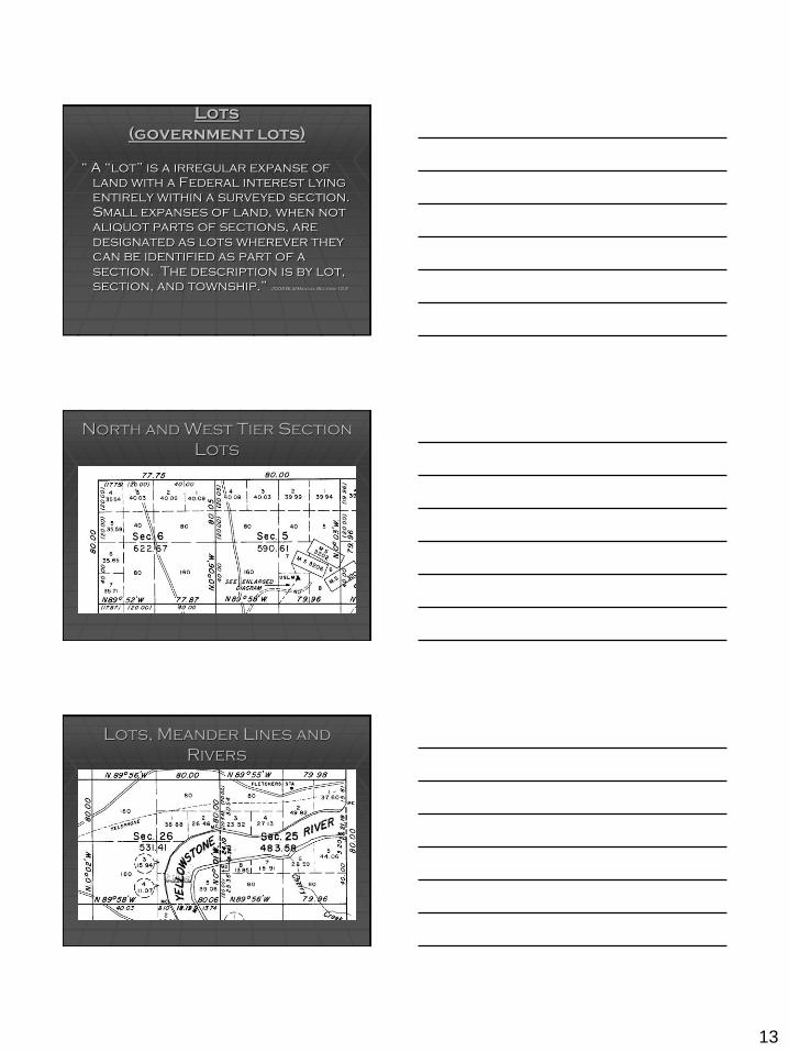
Lots
(government lots)
“ A “lot” is a irregular expanse of
land with a Federal interest lying
entirely within a surveyed section.
Small expanses of land, when not
aliquot parts of sections, are
designated as lots wherever they
can be identified as part of a
section. The description is by lot,
section, and township.” 2009 BLM Manual Section 10-3
North and West Tier Section
Lots
Lots, Meander Lines and
Rivers
Page 14
14
Littoral Lots
Combination of reasons for
Lots
Fractional Townships
1. Survey of the East Line of the Blackfeet Indian Reservation
(May 18-27, 1889)
2. Survey of the north township lines for Township 33 North,
Range 5 and 6 West (May 22 – June 19, 1900)
3. Retracement of the East Line of the Blackfeet Indian
Reservation (June 15 – July 19, 1900)
Page 15
15
Fractional Townships
4. Subdivision of sections and meander lines, east of the East
Blackfeet Indian Reservation Line(June 13-15, 1900)
Fractional Townships
5. Survey of the Township Exterior Lines west of the East Line
of the Blackfeet Indian Reservation (July 10-30, 1907)
Fractional Townships
6. Subdivision of the Fractional Township west of the East
Line of the Blackfeet Indian Reservation (August 23-29,
1907)
Page 16
16
Fractional Townships
6. Subdivision of the sections of the Fractional Township west
of the East Line of the Blackfeet Indian Reservation (June 7-
25, 1923)
Notes 1889
2015
Page 17
17
The Anatomy of a Boundary
Survey
The need arises for a boundary survey to be commissioned
Professional research
Deeds (including adjoining deeds and other title
documents)
May include chaining title back to patent
Certified Corner Recordation Forms
BLM documents
Existing surveys
In the field research and measurements
Recovery of controlling monuments and existing parcel
corners
Mapping of pertinent features
Data Analysis
Potential for further in the field research and additional
data analysis
Resolving a boundary based upon evidence
Setting monuments
Preparing a map of record showing the establishment or
reestablishment of parcel corners
Page 18
18
THANK YOU
Questions????