MAUMEE RIVER STUDY PLAN MAUMEE RIVER STUDY PLAN FINAL Maumee River LRAUs: 041000059001, 041000099001, 041000099002 Auglaize River LRAU: 041000079001 Tiffin River LRAU: 041000069001 State of Ohio Environmental Protection Agency Division of Surface Water Lazarus Government Center 50 W.Town Street, Suite 700 Columbus, OH 43125 Ecological Assessment Section 4675 Homer Ohio Lane Groveport, OH 43125 Division of Surface Water Northwest District Office 347 North Dunbridge Rd. Bowling Green, OH 43402 May 2, 2012
Transcript
MAUMEE RIVER STUDY PLAN
MAUMEE RIVER STUDY PLAN
FINAL
Maumee River LRAUs: 041000059001, 041000099001, 041000099002
Auglaize River LRAU: 041000079001 Tiffin River LRAU: 041000069001
State of Ohio Environmental Protection Agency
Division of Surface Water Lazarus Government Center 50 W.Town Street, Suite 700
Columbus, OH 43125
Ecological Assessment Section 4675 Homer Ohio Lane Groveport, OH 43125
Division of Surface Water Northwest District Office 347 North Dunbridge Rd. Bowling Green, OH 43402
May 2, 2012
MAUMEE RIVER STUDY PLAN
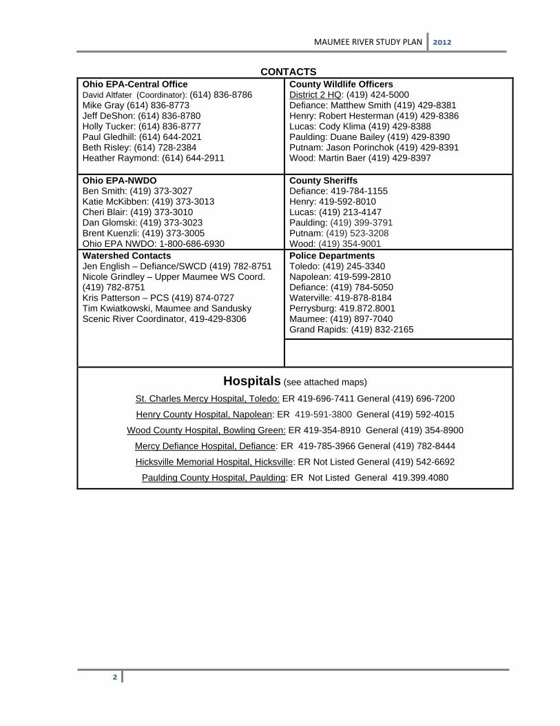
CONTACTS
Ohio EPA-Central Office David Altfater (Coordinator): (614) 836-8786 Mike Gray (614) 836-8773 Jeff DeShon: (614) 836-8780 Holly Tucker: (614) 836-8777 Paul Gledhill: (614) 644-2021 Beth Risley: (614) 728-2384 Heather Raymond: (614) 644-2911
County Wildlife Officers District 2 HQ: (419) 424-5000 Defiance: Matthew Smith (419) 429-8381 Henry: Robert Hesterman (419) 429-8386 Lucas: Cody Klima (419) 429-8388 Paulding: Duane Bailey (419) 429-8390 Putnam: Jason Porinchok (419) 429-8391 Wood: Martin Baer (419) 429-8397
St. Charles Mercy Hospital, Toledo: ER 419-696-7411 General (419) 696-7200
Henry County Hospital, Napolean: ER 419-591-3800 General (419) 592-4015
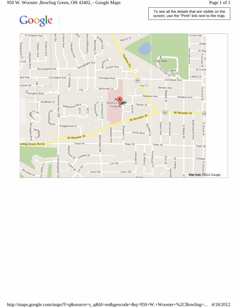
Wood County Hospital, Bowling Green: ER 419-354-8910 General (419) 354-8900
Mercy Defiance Hospital, Defiance: ER 419-785-3966 General (419) 782-8444
Hicksville Memorial Hospital, Hicksville: ER Not Listed General (419) 542-6692
Paulding County Hospital, Paulding: ER Not Listed General 419.399.4080
MAUMEE RIVER STUDY PLAN
INTRODUCTION
During the 2012 field season chemical, physical, and biological sampling will be conducted in the Maumee River mainstem and lower Tiffin River and Auglaize River mainstems to assess and characterize water quality conditions. Comprehensive river monitoring will occur in the following Large River Assessment Units (LRAU): Maumee River – Indiana Border to Tiffin River (42.11 miles), #041000059001 Maumee River – Tiffin River to Beaver Creek (34.44 miles), # 041000099001 Maumee River – Beaver Creek to Maumee Bay (31.32 miles) #041000099002 Auglaize River – Ottawa River (RM 33.26) to mouth, # 041000079001 Tiffin River – Brush Creek to mouth (19.67 miles), #041000069001 The entire length of the Maumee River (RM 107.87- 0) has not been completely assessed since 1997 and therefore will have a thorough assessment of the mainstem, including the freshwater estuary section near the mouth. Additionally, LRAU segments of the lower Auglaize River and lower Tiffin River will be assessed. Table 1 contains a list of all the NPDES facilities on or in close proximity to the Maumee River, Auglaize River, and Tiffin River within the study reaches. The sampling effort is structured to characterize point source and non-point source impacts, including those from unsewered communities and agricultural activities. Sampling locations, geographical coordinates, and types of sampling scheduled for the study area are listed in Table 2. Sampling Objectives
Monitor and assess the chemical, physical and biological integrity of the entire length of the Maumee River, and lower sections of the Auglaize River and Tiffin River.
Assess conditions in impounded, free-flowing, and freshwater estuary segments.
Determine aquatic impacts from known potential pollution sources including point source dischargers.
Assess physical habitat influences on river biotic integrity.
Determine recreational water quality and use attainment.
Collect fish samples for the Ohio Sport Fish Tissue Monitoring Program (used to assess chemical contaminant levels in fish).
Report on the status of aquatic life, recreation, public water supply and fish consumption uses in the Integrated Water Quality Monitoring and Assessment Report.
Collect data needed for TMDL development.
MAUMEE RIVER STUDY PLAN
SAMPLING METHODS/QUALITY ASSURANCE
Field Measurements Multi-probe field measurements will be collected in conjunction with all water samples for the following parameters:
Temperature ( C) Conductivity/Specific conductance (µmhos/cm) Dissolved oxygen (mg/l) + percent oxygen saturation pH (S.U.)
One round of sampling for semi-volatile organic compounds (Method 625) will be done at select sites as indicated by a “CO” in Table 2 during the summer index period. The results will be evaluated and a second set of samples will be collected if necessary.
Five rounds of sampling for herbicides (Method 525.2) will be done at Public Water Supply intakes as indicated by a “W” in Table 2. Sampling will start as early as March 1 and duties will be coordinated between DDAGW-CO and DSW-NWDO staff. Spring runoff events will be targeted if possible.
All Surface water grab samples will be collected from the upper 12 inches of river water and divided into appropriate containers. Collected water will be preserved using appropriate methods, as outlined in Parts II and III of the Manual of Ohio EPA Surveillance Methods and Quality Assurance Practices (Ohio EPA 2012a) and delivered to the Ohio EPA lab for analysis. The analyte list and analytical methods to be used for surface water samples is provided in Table 3.
Sediment Sampling Sediment samples will be collected at locations indicated in Table 2 using the procedures outlined in the Ohio EPA sediment sampling manual (Ohio EPA 2012b). Chemical parameters to be tested for sediment samples and analytical methods are listed in Table 3. Fine grained multi-incremental sediment samples will be collected in the upper 4 inches of bottom material using either decontaminated stainless steel scoops or Ekman dredges. Collected sediment will be placed into
MAUMEE RIVER STUDY PLAN
glass jars with Teflon-lined lids (organics testing) and HDPE plastic containers (metals testing), placed on ice (to maintain 4
oC) and delivered to the Ohio EPA DES laboratory. Analysis of sediment
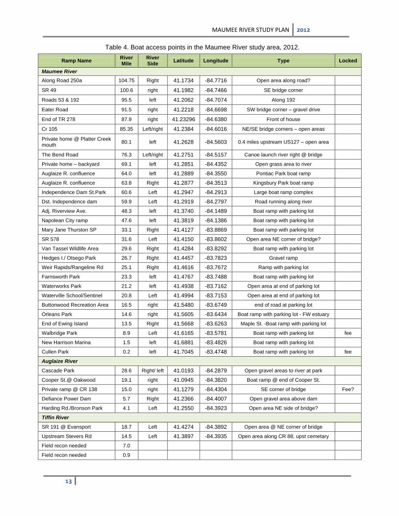
samples will include semi-volatile organic constituents, pesticides, PCB’s, and heavy metals including mercury. Bacteriological Sampling Samples will be collected at all of the sentinel sites and nearly all chemistry sampling sites as listed in Table 2 for bacteriological analyses to determine the attainment status for recreational uses. Testing will be for counts of E. coli bacteria. Water samples will be collected into sterilized polyethylene containers, cooled to 4°C, and transported to the NWDO contract laboratory within 6 hours of sample collection. All samples will be analyzed for E. coli bacteria using U.S.EPA approved methods (STORET Parameter Code 31633). Sites will be sampled five times during the recreation season (May 1 – October 15) under normal flow regimes in order to assess ambient bacteria levels when recreation is most likely to occur. Sentinel testing sites will have bacteria samples collected ten times during the period of March 1, 2012 through December 31, 2012. Ohio EPA staff will assess each sampling site to determine the appropriate recreational criteria to apply using the definitions provided in OAC 3745-1-07(B)(4). Nearby USGS gaging stations (Table 5) may be consulted in order to determine appropriate flow regimes in which to schedule sampling events. The bacteria samples are collected independent from the water chemistry samples. Macroinvertebrate Community Assessment Macroinvertebrates will be collected from artificial substrates and from the natural habitats. Quantitative sampling using artificial substrates will be conducted at all sampling sites. The artificial substrate collection provides quantitative data and consists of a composite sample of 5 modified Hester-Dendy (HD) multiple-plate samplers colonized for six weeks. At the time of the artificial substrate collection, a qualitative multihabitat composite sample is also collected. This sampling effort consists of an inventory of all observed macroinvertebrate taxa from the natural habitats at each site with no attempt to quantify populations other than notations on the predominance of specific taxa or taxa groups within major macrohabitat types (e.g., riffle, run, pool, margin). Macroinvertebrate sampling in impounded sections of river and the Maumee freshwater estuary will incorporate the following procedures: at each sampling location, two HDs will be set – one mid-channel to capture the best flow conditions, and one nearer shore as a backup set. Fish Assemblages and Habitat Fish will be sampled at each sampling location with boat mounted pulsed DC current. Two passes will be conducted at each fish community assessment site (Table 3). Detailed biological sampling protocols are documented in the Ohio EPA manual Biological Criteria for the Protection of Aquatic Life, Volume III (Ohio EPA, 1989b). Qualitative Habitat Evaluation Index (QHEI) scores will be calculated for the river habitat at all fish sampling locations. Boat access points are noted in Table 4. Fish Tissue Tissue fillet samples will be collected from fish of edible size, and species preferred for analysis include largemouth bass, smallmouth bass, flathead catfish, walleye, saugeye, white bass, common carp, freshwater drum, channel catfish and smallmouth buffalo. When possible, composite samples (by species) will be collected using a minimum of three fish and a minimum of 150 grams of material. At each sampling location, an attempt will be made to collect five fish species for fillet tissue analysis. Fish will be sampled using boat electrofishing methods. Sampling locations are listed in Table 2.
Fish used for tissue analysis will be filleted in the field using decontaminated stainless steel fillet knives. Filleted samples will be wrapped in aluminum foil, placed in a sealed plastic bag, and placed on dry ice. Sampling and decontamination protocols will follow those listed in the Ohio EPA Fish Tissue Collection Manual (2012c). Fish tissue samples will be stored in chest freezers at the Ohio EPA Groveport Field Facility prior to delivery to DES.
MAUMEE RIVER STUDY PLAN
Nutrients To help evaluate the potential for continued, new, or abated nutrient impairment, additional analyses are being requested. Specifically, water column chlorophyll a samples should be collected twice during the summer during stable base flow conditions from sentinel and impounded sites (see table 2). Optimally, those samples should be collected in concert with the deployment of automated data loggers that record hourly dissolved oxygen, pH, temperature and conductivity. Additionally, samples for analysis of 5-day biochemical oxygen demand and alkalinity should, at a minimum, accompany the chlorophyll a samples collected from the Maumee River mainstem, and optimally be collected during each of the chemical sampling runs. A dissolved phosphorus sample should be collected with each chlorophyll a sample. Flow Monitoring Flow measurements will be collected periodically at the sentinel site locations under varying flow conditions in order to develop a rating curve for water depth and/or bridge tape readings vs. stream flow. Bridge tape readings will be collected at each sentinel site every time a water sample or flow measurement is collected. Stream flow measurements will be taken using either wading or floating acoustic Doppler flow velocity meters. Stream velocity measurements will be integrated with stream depth measurements to calculate the total stream flow using established USGS methods. Quality Control An acid blank will be run on new lots of acids used for preservation of samples. Matrix spike duplicates will be collected for organic water samples at a minimum of 5 percent. Field meters will be calibrated daily, using manufacturer guidelines and requirements noted in the Manual of Ohio EPA Surveillance Methods and Quality Assurance Practices (Ohio EPA 2012a). Ohio EPA Manuals All biological, chemical, EPA laboratory, data processing, and data analysis methods and procedures adhere to those specified in the Manual of Ohio EPA Surveillance Methods and Quality Assurance Practices (Ohio EPA 2012a), Biological Criteria for the Protection of Aquatic Life, Volumes II - III (Ohio Environmental Protection Agency 1987, 1989a, 1989b), The Qualitative Habitat Evaluation Index (QHEI); Rationale, Methods, and Application (Rankin 1989) for habitat assessment, Ohio EPA Sediment Sampling Guide and Methodologies (Ohio EPA 2012b), and Ohio EPA Fish Tissue Collection Manual (Ohio EPA 2012c). Use Attainment Attainment/non-attainment of aquatic life uses will be determined by using biological criteria codified in Ohio Administrative Code (OAC) 3745-1-07, Table 7-15. Numerical biological criteria are based on multimetric biological indices including the Index of Biotic Integrity (IBI) and modified Index of Well-Being (MIwb), indices measuring the response of the fish community, and the Invertebrate Community Index (ICI), which indicates the response of the macroinvertebrate community.
Performance expectations for the basic aquatic life uses (Warmwater Habitat [WWH], Exceptional Warmwater Habitat [EWH], and Modified Warmwater Habitat [MWH] were developed using the regional reference site approach (Hughes et al. 1986; Omernik 1987). This fits the practical definition of biological integrity as the biological performance of the natural habitats within a region (Karr and Dudley 1981). Attainment of an aquatic life use is FULL if all three indices (or those available) meet the applicable criteria, PARTIAL if at least one of the indices did not attain and performance did not fall below the fair category, and NON if all indices either fail to attain or any index indicates poor or very poor performance. The results will be compared to WWH or MWH-I biocriteria for the Huron Erie Lake Plain ecoregion. Recreational use attainment will be determined using E. coli bacteria. E. coli are indicator organisms for the potential presence of pathogens in surface water resulting from the presence of untreated human or animal wastes, and they are the basis for recreational use water quality criteria in Rule 3745-1-07 of the Ohio Administrative Code (OAC).
MAUMEE RIVER STUDY PLAN
Stream Habitat Evaluation Physical habitat is evaluated using the Qualitative Habitat Evaluation Index (QHEI) developed by the Ohio EPA for streams and rivers in Ohio (Rankin 1989). Various attributes of the available habitat are scored based on their overall importance to the establishment of viable, diverse aquatic faunas. Evaluations of type and quality of substrate, amount of instream cover, channel morphology, extent of riparian canopy, pool and riffle development and quality, and stream gradient are among the metrics used to evaluate the characteristics of a stream segment, not just the characteristics of a single sampling site. As such, individual sites may have much poorer physical habitat due to a localized disturbance yet still support aquatic communities closely resembling those sampled at adjacent sites with better habitat, provided water quality conditions are similar. QHEI scores from hundreds of segments around the state have indicated that values higher than 60 were generally conducive to the establishment of warmwater faunas while those which scored in excess of 75-80 often typify habitat conditions which have the ability to support exceptional faunas.
Sampling Summary A summary of the number of samples to be collected during the 2012 survey is provided in Table 6.
RAP BENEFICIAL USE IMPAIRMENTS
The Maumee Area of Concern (AOC) does not include the entire Maumee River watershed. It includes the lower reach and tributaries, as well as some of the neighboring watersheds. The boundaries of the Maumee Area of Concern (AOC) were originally identified in 1987 as the area extending from the Bowling Green water intake near Waterville along the Lower Maumee River at river mile 22.8 downstream to Maumee Bay. The area includes direct drainage into the waters that are within Lucas, Ottawa and Wood counties. This includes Swan Creek, Ottawa River (Ten Mile Creek), Duck Creek, Otter Creek, Grassy Creek, Cedar Creek, and Crane Creek. In 1992, this area was extended to the east to include Turtle Creek, Packer Creek, and the Toussaint River. The Maumee Area of Concern (AOC) covers 775 square miles. The Maumee AOC was again modified in 2010 to align its boundaries with 10-digit HUCs. This change primarily added the headwaters of Swan Creek and the Ottawa River to the Maumee AOC and changed the upstream boundary of the Maumee River mainstem to approximately RM 21 (just upstream of the State Route 64 bridge in Waterville). A Maumee RAP is currently in the process of addressing beneficial use impairments (BUI’s) identified for the AOC (for information see U.S.EPA’s web site: http://www.epa.gov/greatlakes/aoc/maumee.html). Concurrent with this sampling plan, two additional monitoring efforts are underway in the lower Maumee River assessment unit (HUC 041000099002). One is in conjunction with the Great Lakes Restoration Initiative (GLRI) and the other is a Great Lakes Legacy Act (GLLA) sediment site characterization. Data collected, as outlined in this study plan, will also help the Maumee RAP program to better determine the status of BUIs within the Maumee AOC. Goals and procedures for Ohio EPA’s monitoring efforts in the Maumee River freshwater estuary related to a nearshore Lake Erie monitoring grant under the GLRI are included in a separate monitoring plan (Ohio EPA 2011).
Park Place MHP 2PY00065 Defiance 5.0, 1.03 0.0125 MGD Sand Filtration 1 – Discharge points on tributaries to the Maumee, Auglaize, or Tiffin Rivers are noted by two river miles (e.g. 5.0, 1.03), the
tributary confluence point to the main river (first river mile number), and the wastewater discharge point on the tributary (second river mile number).
MAUMEE RIVER STUDY PLAN
Table 2. Maumee River, Auglaize River, and Tiffin River sampling locations.
River Mile
EA3 Station Sample Type Location Latitude
Longitude
Purpose
Maumee River (04-001)
NA NA M,F,C,D New Haven USGS gage - IN 41.08487 -85.02131 Indiana - downstream Ft. Wayne
104.7 P06K09 M,F,C,FT,D,B 1.0 mile west of Antwerp 41.1739 -84.7717 Baseline –most upstream site in Ohio
99.0 201868 M,F,C,FT,D,SE,N,B Antwerp@ Antwerp City Park 41.1839 -84.7325 Sentinel Site
91.5 P06S08 M,F,C,FT,D,B NE of Antwerp – Eater Rd. 41.2219 -84.6697 Downstream Antwerp, CAFO area
85.3 P06K06 M,F,C,FT,D,B N of Cecil @ CR 105 41.2378 -84.6022 Downstream Marie DeLarme Creek
79.7 P06K05 M,F,C,FT,D,B US 127 41.2619 -84.5564 Downstream Gordon Creek
76.1 P06S07 M,F,C,FT,D,SE,N,B The Bend Road 41.2753 -84.5150 Sentinel Site, downstream Sherwood
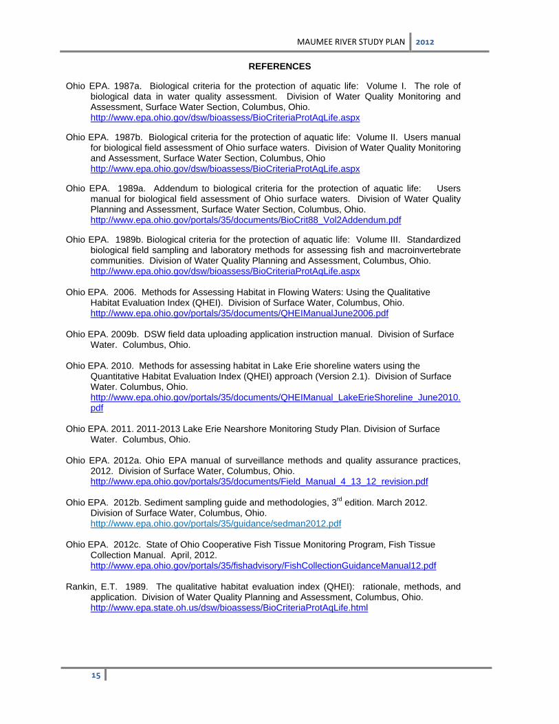
REFERENCES Ohio EPA. 1987a. Biological criteria for the protection of aquatic life: Volume I. The role of
biological data in water quality assessment. Division of Water Quality Monitoring and Assessment, Surface Water Section, Columbus, Ohio. http://www.epa.ohio.gov/dsw/bioassess/BioCriteriaProtAqLife.aspx
Ohio EPA. 1987b. Biological criteria for the protection of aquatic life: Volume II. Users manual
for biological field assessment of Ohio surface waters. Division of Water Quality Monitoring and Assessment, Surface Water Section, Columbus, Ohio
http://www.epa.ohio.gov/dsw/bioassess/BioCriteriaProtAqLife.aspx Ohio EPA. 1989a. Addendum to biological criteria for the protection of aquatic life: Users
manual for biological field assessment of Ohio surface waters. Division of Water Quality Planning and Assessment, Surface Water Section, Columbus, Ohio.
http://www.epa.ohio.gov/portals/35/documents/BioCrit88_Vol2Addendum.pdf Ohio EPA. 1989b. Biological criteria for the protection of aquatic life: Volume III. Standardized
biological field sampling and laboratory methods for assessing fish and macroinvertebrate communities. Division of Water Quality Planning and Assessment, Columbus, Ohio.
http://www.epa.ohio.gov/dsw/bioassess/BioCriteriaProtAqLife.aspx Ohio EPA. 2006. Methods for Assessing Habitat in Flowing Waters: Using the Qualitative
Habitat Evaluation Index (QHEI). Division of Surface Water, Columbus, Ohio. http://www.epa.ohio.gov/portals/35/documents/QHEIManualJune2006.pdf
Ohio EPA. 2009b. DSW field data uploading application instruction manual. Division of Surface
Water. Columbus, Ohio. Ohio EPA. 2010. Methods for assessing habitat in Lake Erie shoreline waters using the
Quantitative Habitat Evaluation Index (QHEI) approach (Version 2.1). Division of Surface Water. Columbus, Ohio. http://www.epa.ohio.gov/portals/35/documents/QHEIManual_LakeErieShoreline_June2010.pdf
Ohio EPA. 2011. 2011-2013 Lake Erie Nearshore Monitoring Study Plan. Division of Surface
Water. Columbus, Ohio. Ohio EPA. 2012a. Ohio EPA manual of surveillance methods and quality assurance practices,
2012. Division of Surface Water, Columbus, Ohio. http://www.epa.ohio.gov/portals/35/documents/Field_Manual_4_13_12_revision.pdf
Ohio EPA. 2012b. Sediment sampling guide and methodologies, 3rd
edition. March 2012. Division of Surface Water, Columbus, Ohio. http://www.epa.ohio.gov/portals/35/guidance/sedman2012.pdf
Ohio EPA. 2012c. State of Ohio Cooperative Fish Tissue Monitoring Program, Fish Tissue Collection Manual. April, 2012. http://www.epa.ohio.gov/portals/35/fishadvisory/FishCollectionGuidanceManual12.pdf
Rankin, E.T. 1989. The qualitative habitat evaluation index (QHEI): rationale, methods, and
application. Division of Water Quality Planning and Assessment, Columbus, Ohio. http://www.epa.state.oh.us/dsw/bioassess/BioCriteriaProtAqLife.html
Home | Directions | Contact Us | Ways to Give Search for:
Directions to Henry County Hospital1600 East Riverview Avenue Napoleon, OH 43545 419-592-4015
From the North Take State Route108 South Turn left (East) onto State Route 24 Exit State Route 24 at the Industrial Drive exit Turn right off of the exit ramp Turn left on State Route 424/Riverview Avenue The Henry County Hospital will be on the left hand side approximately 2 miles
From the West Take State Route 24 East Exit State Route 24 at the Industrial Drive exit Turn right off of the exit ramp Turn left on State Route 424/Riverview Avenue The Henry County Hospital will be on the left hand side approximately 2 miles
From the South Take State Route 108 North to Napoleon Turn right on State Route 424/Riverview Avenue The Henry County Hospital will be on the left hand side approximately 4 miles
From the East Take State Route 24 West to Napoleon Turn left on State Route 424/Riverview Avenue The Henry County Hospital will be on the right hand side approximately 2 miles
1600 East Riverview Ave. Napoleon, Ohio 43545 | p. 800-569-7948 | p. 419-592-4015 | f. 419-592-4017 | Privacy Statement | Disclaimer | Legal | Site Map Copyright 2011 Henry County Hospital | Designed & Developed by Genessa Health
I-75 North Exit 125 - Rt. 309/Rt. 117 West (toward Lima) Rt. 65 North Rt. 15 North E. Second St. turn right 1404 E. Second St. From Ohio Turnpike
I-80 West Exit 64 - I-75 South Merge to I-475 West/Rt. 23 North Exit Rt. 24 West Waterville Rt. 281 (Domersville Rd.) turn left E. Second St. Turn right 1404 E. Second St. www.mercyweb.org
To see all the details that are visible on the screen, use the "Print" link next to the map.
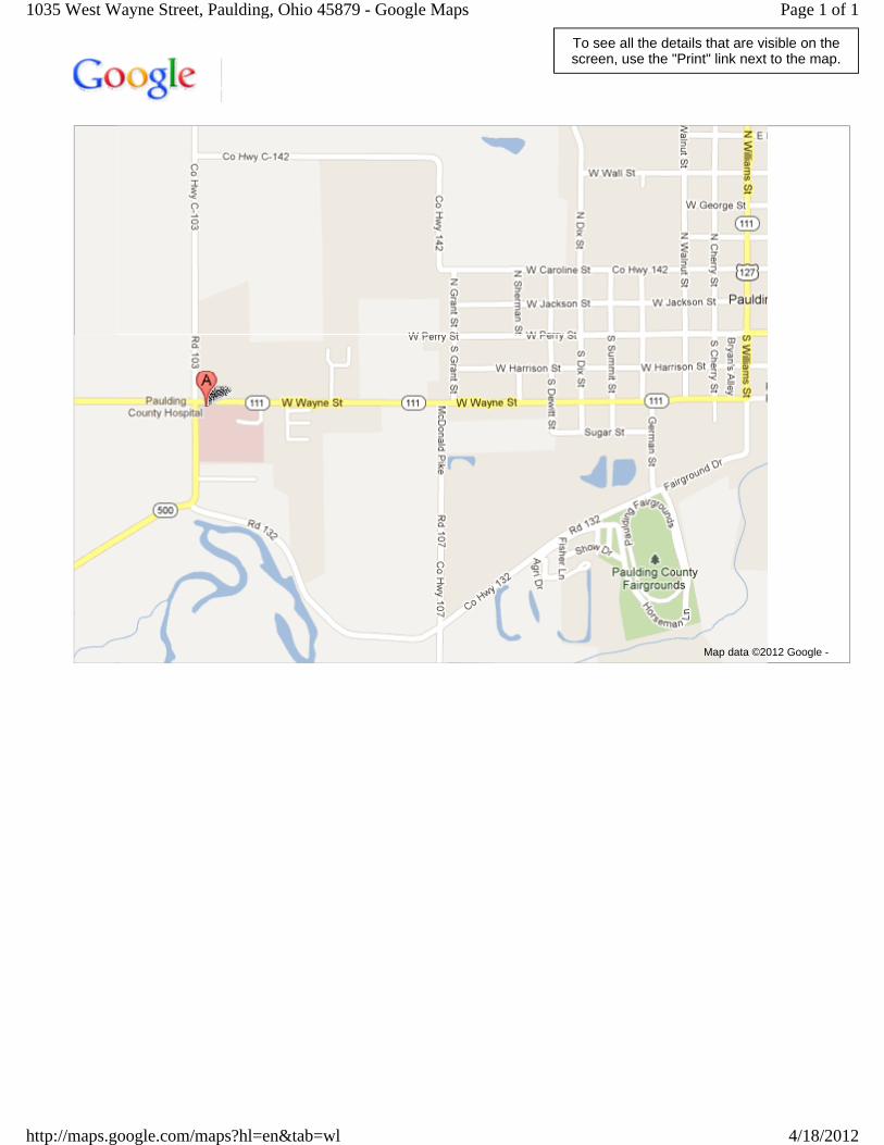
Page 1 of 11035 West Wayne Street, Paulding, Ohio 45879 - Google Maps
4/18/2012http://maps.google.com/maps?hl=en&tab=wl
Mercy St. Charles Hospital Maps & Directions
Directions to Mercy St. Charles Hospital using Google Maps
From Toledo & Points Northwest
I-475 East to I-75 North to I-280 South. I-280 South to Exit 7, Oregon (State Route 2/Navarre). Turn left off of exit ramp onto Route 2 heading East. Turn right on Wheeling.
From Toledo Downtown
Head East on Cherry Street crossing Martin Luther King Bridge. Turn left on Starr. Follow Starr to Wheeling, Turn right on Wheeling. The hospital is on Wheeling at Navarre Avenue. Total miles from downtown to hospital is approximately 4 miles.
Follow signs to I-80/90 (Ohio Turnpike). I-80/90 East to Exit 5, I-280. I-280 North to Exit 7, Oregon (State Route 2/Navarre). Turn right (North) off exit ramp onto Wheeling.
From Columbus & Central Points
State Route 23 North. Connect with I-75 North near Findlay; follow signs toward Toledo. I-75 North to 795 East. 795 East to I-280 North. I-280 North to Exit 7, Oregon (State Route 2/Navarre). Turn right (North) off exit ramp onto Wheeling.
From Cincinnati/Dayton & Southwestern Points
I-75 North towards Toledo. I-75 North to 795 East. 795 East to I-280 North to Exit 7, Oregon (State Route 2/Navarre). Turn right (North) off exit ramp onto Wheeling.
From Detroit & Points North
I-75 South toward Toledo. I-280 South to Exit 7, Oregon (State Route 2/Navarre). Turn left off of exit ramp onto Route 2 heading East. Turn right on Wheeling.
From Detroit Airport
Follow signs for Toledo to I-94. I-94 West to I-275. I-275 South to I-75 South towards Toledo. I-280 South to Exit 7, Oregon (State Route 2/Navarre). Turn left off of exit ramp onto Route 2 heading East. Turn right on Wheeling.
From Ohio Turnpike East or West Points
I-80/90 (Ohio Turnpike) toward Toledo to Exit 5 (I-280). I-280 North to Exit 7, Oregon (Route 2/Navarre). Turn right (North) off exit ramp onto Wheeling.
From Cleveland Option #2
I-80/90 (Ohio Turnpike) West toward Toledo to Exit 7, Sandusky. 250 North to State Route 2. State Route 2 West (through Port Clinton & Oak Harbor. Turn left on Wheeling.
From Anthony Wayne Trail (US-24)
Exit Collingwood Avenue/toward I-75 South Turn right on Collingwood Avenue Turn Left on Broadway Street Right on Clayton over bridge becomes Woodville Rd. Turn left on Navarre Avenue