+ All Categories
Home > Documents > May 17, 2016 Testimony of Tom Buman, CEO of Agren For the ... · Testimony of Tom Buman, CEO of...

May 17, 2016 Testimony of Tom Buman, CEO of Agren For the ... · Testimony of Tom Buman, CEO of...

Date post: 11-Jul-2018
Category:
Upload: vanquynh
View: 213 times
Download: 0 times
Share this document with a friend
12
May 17, 2016 Testimony of Tom Buman, CEO of Agren For the House Agriculture Sub-Committee on Conservation and Forestry Hearing Topic: Solutions through Voluntary and/or Locally Led Conservation Efforts Chairman Thompson, Ranking Member Lujan Grisham, and Members of the Subcommittee, thank you for the opportunity to appear before the Subcommittee on Conservation and Forestry and to provide testimony regarding innovative solutions for conservation. My name is Tom Buman. I was raised on a farm in Western Iowa, where my parents instilled in me a deep conviction for agriculture and the environment. Today, I am still connected to my family farm, which my brother operates. For the past 20 years, I have been the CEO of Agren, where I have married my love of agriculture and the environment to my passion for pioneering innovative solutions to environmental problems. At Agren, I drive concept development and continuously challenge scientists, programmers and subject matter experts to achieve a higher level of innovation. I am also responsible for leading business development and strategic partnerships. Prior to founding Agren in 1996, I spent 14 years with the Natural Resources Conservation Service in Iowa, first as a Soil Conservationist and later as a District Conservationist. I have a Bachelor of Science degree in Agronomy (1982) and a Masters in Business Administration (1995), both from Iowa State University. I am proud to say that Agren’s suite of precision conservation software is revolutionizing soil and water management. Our online conservation planning tools enable users to get done in minutes what farmers have traditionally waited on for weeks and months. Our customers can now offer practical, value-added soil and water management solutions, empowering farmers and land managers to make profitable decisions that ultimately enhance agricultural productivity and sustainability.
Transcript

May 17, 2016

Testimony of Tom Buman, CEO of Agren

For the House Agriculture Sub-Committee on Conservation and Forestry

Hearing Topic: Solutions through Voluntary and/or Locally Led Conservation Efforts

Chairman Thompson, Ranking Member Lujan Grisham, and Members of the Subcommittee, thank you

for the opportunity to appear before the Subcommittee on Conservation and Forestry and to provide

testimony regarding innovative solutions for conservation.

My name is Tom Buman. I was raised on a farm in Western Iowa, where my parents instilled in me a

deep conviction for agriculture and the environment. Today, I am still connected to my family farm,

which my brother operates.

For the past 20 years, I have been the CEO of Agren, where I have married my love of agriculture and the

environment to my passion for pioneering innovative solutions to environmental problems. At Agren, I

drive concept development and continuously challenge scientists, programmers and subject matter

experts to achieve a higher level of innovation. I am also responsible for leading business development

and strategic partnerships.

Prior to founding Agren in 1996, I spent 14 years with the Natural Resources Conservation Service in

Iowa, first as a Soil Conservationist and later as a District Conservationist. I have a Bachelor of Science

degree in Agronomy (1982) and a Masters in Business Administration (1995), both from Iowa State

University.

I am proud to say that Agren’s suite of precision conservation software is revolutionizing soil and water

management. Our online conservation planning tools enable users to get done in minutes what farmers

have traditionally waited on for weeks and months. Our customers can now offer practical, value-added

soil and water management solutions, empowering farmers and land managers to make profitable

decisions that ultimately enhance agricultural productivity and sustainability.

Let’s just get it out there. We, in the farming community need to do more conservation. We need to up

our game. What we are doing is simply not enough. But just as importantly as doing more, is doing

more of the right thing. Yes, doing more and doing more of the right thing are completely different. It’s

no longer good enough for farmers to place a terrace or waterway, wherever they think it’s needed. For

farmers to make a significant impact on soil erosion and water quality, the conservation practice needs

to be targeted for a specific purpose. And that is the challenge facing today’s farmers; putting the right

practice in the right place.

I’d like to use a simple health analogy to demonstrate my point. What if your doctor tells you that you

have a high risk - 1 in 5 chances - of having a heart attack in the next 10 years? What would you do?

You’re now challenged with making some critical decisions. The research tells you that modifying certain

risk factors can improve your odds. You probably have an idea what those risk factors are. Some are

simple strategies, while others are more complex. You could exercise. You could cut saturated fat from

your diet. You could lose weight. You could take daily baby aspirin or medication to lower cholesterol.

You might even envision the need for surgery. A combination of life style change strategies might make

a bigger difference, but you want to be sure. You want the best course of action for the best outcome,

based on your current health and lifestyle. So you turn to an expert, your doctor, to distill the

information and help you develop an individualized plan.

Farmers also want what works best for the health of their soil and the cleanliness of their water, as well

as for their pocketbook. But they lack critical decision-making tools. Just as health decisions are driven

by individual health information, today’s conservation decisions should be based on individualized, site-

specific resource concerns; an individualized plan to put the right practice, in the right place, for the

right purpose. This precision conservation, like the practice of medicine, is an art and a science. With

recent advances in innovative technology, combined with site-specific information and accessible

technical assistance, farmers can do more to achieve the most environmental protection, for the lowest

cost, while meeting the goals of their operation.

Let’s examine the current status of accessible technical assistance. If we agree that farmers need

technical assistance to interpret information, implement conservation and do more of the “right thing,”

we should ask ourselves, where do farmers get this help? Government? Probably not. Conservation

agencies are tapped out. Funding for staff resources at both state and federal conservation planning

agencies has been on a steady decline over the past 30 years. An astonishing 5000 full-time employees,

approximately 33% of the total workforce, were cut from the NRCS budget between 1980 and 2016

(Helms, 2010) (Lawrence, 2015). But even if these numbers were restored, it will not make an

appreciable difference to reaching enough farmers.

In the spring of 1981, I was a junior at Iowa State University studying agronomy. My dad had one of the

first outbreaks of black cutworm in the neighborhood. What did he do? He did what every farmer did

at that time. He called the Extension Service. The County Extension Agent came out to the farm,

diagnosed the problem, held a field day for Dad and his neighbors, and helped Dad solve the problem.

Today, unlike 1981, farmers take their agronomy questions straight to their ag retailer because farmers

trust their ag retailer to give them sound advice.

The scale of solving the soil conservation and water quality issue is enormous and farmers should have

the option to seek technical advice from professionals, whom they most trust. Given the magnitude of

the need for technical assistance, the private sector is the only resource that can scale to the challenge.

Conservation through the Private Sector Because the traditional stream of information and technical assistance has been constrained and

because the private sector has improved their capacity, farmers turn to the private sector more often

for information and advice. In their trusted role, ag retailers are positioned to be a farmer’s first line of

information on conservation issues. Furthermore, ag retailers are the only entity with the opportunity

to deliver field scale agronomy, including conservation planning, to U.S. farmers.

Several studies demonstrate that farmers implicitly

trust their ag retailer and have an appetite for their

retailers to do more to protect natural resources.

For example, a 2012 survey of 5,000 Midwestern

corn producers reported their most trusted advisor,

when making decisions about agricultural practices

and strategies, was their chemical or seed dealer.

As depicted in Figure 1, crop advisors came in a

distant second, with conservation agencies,

university extension, and non-governmental

organizations trailing even further (Arbuckle J. ,

2013). Further, a 2015 study of over 1,000 Iowa

farmers found 60% agreeing that their fertilizer or

ag chemical dealer “should do more to help farmers

address nutrient losses into waterways.” Only 9% of

the farmers reported they did not think their ag retailer should provide conservation services (Arbuckle

& Bates, 2015).

Throughout the past two years, my colleagues and I have communicated with several of the largest

precision agriculture providers. They have expressed an interest in, and in some cases excitement

about, delivering conservation technical assistance.

An Example of a Private Sector Offering:

In an effort to get more conservation on the ground, United Suppliers, a customer-owned wholesale

supplier of crop nutrients, crop protection inputs and seed, with headquarters in Ames, Iowa has

stepped forward. United Suppliers is making a significant investment into developing a conservation

planning service through the private sector. They have named their conservation platform SUSTAIN™. To

my knowledge, this offering by United Suppliers is the single largest, private sector investment in soil

conservation planning services offered to farmers.

Figure 1: Chemical dealers top the list of ag’s most trusted advisors.

The SUSTAIN™ service platform includes soil loss estimates and initial planning of conservation

structures, including grassed waterways, water and sediment control basins, ponds, and wetlands. “The

new conservation planning service will provide growers assistance in exploring conservation alternatives

that best meet their needs,” said United Suppliers President & CEO Brad Oelmann.

What a change. Even 5 years ago, it was difficult

to imagine a major ag fertilizer/chemical dealer

developing a platform with such a bold Vision

Statement, “improve the capabilities and

competitiveness of United Suppliers’ Owners by

positioning them as leaders of the

environmentally sustainable agriculture

movement, both in the agriculture industry and

in the communities they serve.” And following

up with a Mission Statement of “offering a

leading-edge, economically sound and forward-

thinking pathway through which Owners can

deliver significant benefits for growers, and do so

in ways that are good for the environment and

meet the demands of the supply chain for

fertilizer optimization and soil health.”

To add to this excitement, in October of 2015,

United Suppliers entered into a joint venture

with WinField Solutions, the crop input business

unit of Land O’Lakes, creating WinField US. A full

merger of the two organizations will be

completed in October of 2017. Precision soil and

water management has emerged as a high-priority and best fit for the WinField US sustainability

platform. WinField US believes that helping their growers conserve soil resources is essential for their

productivity and profitability, as well as for the expanding global population. As a major first step, the

organization’s leadership is working to partner with the Minnesota Department of Agriculture to

support farmer participation in the Minnesota Agricultural Water Quality Certification Program via the

WinField US cooperative retail network.

Technology and Precision Conservation Just like technology revolutionized precision agriculture, precision conservation will be accelerated with

new, innovative technologies and approaches.

In 2006, Agren entered into the world of high tech software. With a Conservation Innovation Grant

from NRCS we developed 2 software programs; one to design ponds and one to design sediment basins.

The technology is amazing. What used to take me 6 to 20 hours, I could now do in 15 to 20 minutes.

United Suppliers SUSTAIN™ Platform

Vision: SUSTAIN will improve the capabilities

and competitiveness of United Suppliers’ Owners

by positioning them as leaders of the

environmentally sustainable agriculture

movement, both in the agriculture industry and

in the communities they serve”.

Mission: SUSTAIN offers a leading-edge,

economically sound and forward-thinking

pathway through which Owners can deliver

significant benefits for growers, and do so in

ways that are good for the environment and

meet the demands of the supply chain for

fertilizer optimization and soil health”.

However, we didn’t stop there. We

developed more software. We

developed tools for wetlands,

prescribed fire, and then one for

grassed waterways.

Most recently, Agren worked with

USDA’s Agricultural Research Service

(ARS) to commercialize some of their

science and technology. Most people

would refer to this as technology

transfer; I call it unlocking Pandora’s

Box.

ARS is the lead agency for developing

the RUSLE2 (Revised Universal Soil Loss

Equation version2), a computer model

that predicts rill and inter-rill erosion caused by rainfall and runoff. Since its inception, this model has

been used by conservation agencies to model soil erosion at one point in a field. Through a team effort,

Agren developed the same modelling engine (RUSLE2) to calculate soil erosion at 72,000 points in 160

acres with Agren® SoilCalculator. Armed with the outputs of SoilCalculator, ag retailers can help farmers

correlate soil erosion (Figure 3) to yields (Figure 4). Furthermore, ag retailers can begin to help farmers

understand if soil erosion is causing a yield drag and recommend appropriate conservation practices.

Figure 3: Erosion map generated with Agren® SoilCalculator. Figure 4: Farmer yield map.

Figure 2: Pond design generated by Agren® PondBuilder.

The outputs of SoilCalculator are powerful and can be used to drive several other important

environmental models. Agren has collaborated with researchers at the ARS Sedimentation Laboratory

and the University of Tennessee to develop two GIS-based soil loss modeling tools, referred to as the

Revised Universal Soil Loss Equation 2- Raster (RUSLER) and the Ephemeral Gully Erosion Estimator

(EphGEE).

Once sheet and rill erosion could be modelled in a distributed fashion, Agren worked with ARS

researchers Dr. Seth Dabney and Dr. Dalmo Vieira, to also develop a physically-based ephemeral gully

model. Conceptually, the new model is based on the assumptions and methods similar to those used in

the Chemicals, Runoff and Erosion model from Agricultural Management Systems (CREAMS) (Knisel,

1980) and the Water Erosion Prediction Project model (WEPP) (Ascough, Baffaut, Nearing, & Liu, 1997),

but with a number of modifications to remove technical limitations of those older models.

By integrating with RUSLER, the integrated application provides a mechanism for the estimation of

runoff and sediment loads that control the development of ephemeral gullies. EphGEE simulates

ephemeral gully erosion on complex in-field dendritic channel networks, with outputs for channel

erosion and sediment transport, deposition, and delivery to a watershed outlet (Vieira, 2014).

This ability to determine the transport and deposition of soil will allow ag retailer to target practices,

such as water and sediment control basins, to sensitive areas resulting in significant, positive,

environmental impact. With technology like SoilCalculator, ag retailers can effectively and efficiently

implement precision conservation.

Figure 5: Using SoilCalculator in combination with EphGEE, conservation planners can model the sediment that is transported and delivered to waterways. The number in the oval represents the annual delivery of sediment from a subwatershed (measured in tons).

Agren’s Sustainability Solution Platform

Agren developed the Sustainability

Solution platform to allow ag retailers to

introduce soil and water management

solutions alongside their precision ag

offering. The three-tiered platform

supports delivery, sales, and

documentation of soil and water

management services through field

agronomists. As farmer response and the

market for these services grow over time,

the Sustainability Solution allows retailers

to provide a full-suite of precision conservation planning services.

Agren’s three-step model leverages the farm-gate relationship and service-orientation of the agronomy

network. It minimizes both the level of effort and specialized skillset required for the retail agronomist

to engage with farmers on soil and water management. By utilizing ag retailers’ precision ag platform,

the delivery process is streamlined into a consultative sales process familiar to the agronomist. Using

these tools, the retail agronomist is not overburdened by “one more thing” to sell. Incorporating an

experienced and well-trained conservation agronomist into the process ensures quality conservation

planning assistance that builds on core conservation principles and engineering standards. Also, because

the retail agronomist is generating and qualifying leads, the conservation agronomist is able to service

farmers across many locations.

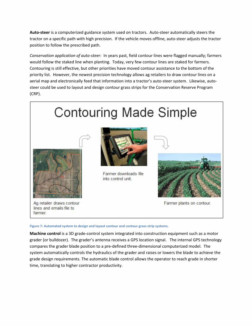
Other Technologies for Conservation

The use of new technology in agriculture should extend well beyond bio-fuels, crop protection,

automated machine control, and seed varieties. Advancements in agriculture technology should be

applied to soil and water conservation, as well. Soil and water conservationists must harness existing

technology to reduce the cost of precision conservation and encourage more effective technology and

knowledge transfer. Agren is integrating existing technologies, such as auto-steer, machine control,

LiDAR and UAVs (un-manned aerial vehicles), into its conservation platform, to improve efficiencies and

farmer/ag retailer adoption.

Figure 6. Agren’s 3-tiered Sustainability Solution

Auto-steer is a computerized guidance system used on tractors. Auto-steer automatically steers the

tractor on a specific path with high precision. If the vehicle moves offline, auto-steer adjusts the tractor

position to follow the prescribed path.

Conservation application of auto-steer: In years past, field contour lines were flagged manually; farmers

would follow the staked line when planting. Today, very few contour lines are staked for farmers.

Contouring is still effective, but other priorities have moved contour assistance to the bottom of the

priority list. However, the newest precision technology allows ag retailers to draw contour lines on a

aerial map and electronically feed that information into a tractor’s auto-steer system. Likewise, auto-

steer could be used to layout and design contour grass strips for the Conservation Reserve Program

(CRP).

Figure 7: Automated system to design and layout contour and contour grass strip systems.

Machine control is a 3D grade-control system integrated into construction equipment such as a motor

grader (or bulldozer). The grader’s antenna receives a GPS location signal. The internal GPS technology

compares the grader blade position to a pre-defined three-dimensional computerized model. The

system automatically controls the hydraulics of the grader and raises or lowers the blade to achieve the

grade design requirements. The automatic blade control allows the operator to reach grade in shorter

time, translating to higher contractor productivity.

Conservation application of machine control: Imagine

a conservationist designing a structure like a grass

waterway using LiDAR data. Once designed, the

conservationist can easily create a 3-D machine

control file and email it to the contractor. The

contractor then uploads the file into the machine

control unit and builds the structure. This could all

happen within one day, with the elimination of field

layout work.

In some locations and for some conservation

practices, contractors already can obtain a 3D machine

control. Given the increased accuracy and

productivity, machine control files should be made

available to all contractors who build conservation

practices.

Currently, Agren can output machine control files for

waterways. By the end of this year, Agren intends to

output machine control files for all structural

practices. Developers (companies like Trimble,

Topcon, and Leica) are poised and waiting to expand

the use of machine control for soil and water conservation. Machine control technology will

fundamentally change how conservation structures are designed, staked, and constructed.

Testimonial from a contractor using machine control to build a grass waterway:

https://www.agrentools.com/construction-marketplace/testimonials/

Figure 8: Motor grader with machine control.

LiDAR is an emerging technology that is

changing conservation planning practices

from coast to coast. An acronym for Light

Detection and Ranging, this term is used in

mapping to describe how location and

elevation data is collected, using laser

beams. To obtain the data, a small aircraft

flies over a land mass and sends out

thousands of light beams to define the

surface of the earth and the heights of

above ground features.

The data initially gathered by a LiDAR

system is raw X, Y and Z coordinates.

Processing of the data points can result in a

highly accurate GIS-based digital elevation

model; essentially a plaster relief of the

landform made from light. Field verification

trials in Iowa, document eight-inch or better

vertical accuracy under leaf-off conditions.

LiDAR has been used for road and culvert design, fire fuel mapping and to visualize the Grand Canyon.

Conservation application of LiDAR: When LiDAR data is combined with tools like the Agren engineering

tools, the information can be used to more quickly and accurately determine optimum locations for

conservation solutions like ponds, waterways and basins. Additionally, the opportunity to almost

instantaneously provide farmers with a visual representation of how their fields might look with

different conservation practices applied is tremendous.

While there is some consensus at a federal level supporting a national database of LiDAR, this effort has

encountered snags. While these snags are being sorted out, cities and states are moving ahead with

their own statewide LIDAR collection. Significant regions of the Eastern United States now have LiDAR

coverage. Although LiDAR is available in many areas, it unfortunately varies in quality. In some cases,

LiDAR is accurate enough for actually engineering practices, but it is always good enough for planning

conservation practices.

NRCS is researching the use of LiDAR. According to USDA, NRCS, “LiDAR suitability for conservation

engineering work is determined by data quality, such as the accuracy and precision of the LiDAR dataset.

Data quality is impacted by aerial flight precision, type and execution of elevational ground control, the

rate and density of sampling, and the level of post processing.” (USDA, NRCS, 2015)

Figure 9: Collecting LiDAR data (Fancher, 2012).

Unmanned Aerial Vehicle

(UAV): Where LiDAR data is

accurate enough only for

planning soil and water

conservation practices,

alternative collection

methods can be used. Using

UAVs is an emerging way to

collect low cost topographic

data.

In the spring of 2016, Dr. Rob Wells, USDA Agricultural Research Service, compared photogrammetry

measurements, of several data collection methods, to determine the accuracy of UAV-collected

topographic data. Dr. Wells found that the UAV methodology provided a highly accurate substitute for

more labor intensive ground collection of topographic data. Dr. Wells reported, using a UAV,

topographic data with a vertical accuracy 1 to 2 cm can easily exceeds the survey quality specified by

NRCS for engineering practices.

Conservation application of Unmanned Aerial Vehicle (UAV): Using a UAV can vastly reduce the time

spent collecting accurate topographic data for conservation practice design. Additionally, UAVs can

collect survey data when soil conditions prevent traditional survey crews from working. In 2016, Agren

contracted with Top Intelligence, a regional provider of drone related technology to fly seven different

sites at two different times, for a total cost of $7,500, or an individual cost of $530/site which includes

process and cleaning the data. The cost of collecting data with UAV in this case, is certainly less

expensive than sending a crew to the field to collect survey data.

Conclusion

Public pressure on agriculture is at an all-time high. The public want foods grown more sustainably and

improved water quality. We, in the ag community, need to up our game. We need to speed up

conservation practice adoption. We know farmers want to receive conservation information from their

ag retailers. And, we know ag retailers are interested in providing this service, but they need

encouragement and motivation to integrate precision conservation with their precision ag

platform. The conservation effort can be accelerated by ag retailers who are equipped with state-of-

the-art technology. It all starts with giving farmers the information they need to make a decision and

providing fast and efficient technical assistance for implementation.

Figure 10: UAV used to collect high quality topographic data.

Works Cited Arbuckle, J. (2013, April 16). Staff:Arbuckle: Iowa State University. Retrieved May 6, 2016, from Iowa

State University Department of Sociology Web site:

http://www.soc.iastate.edu/staff/arbuckle/Arbuckle%20PPT%202013%20Climate%20change%2

0beliefs_concerns_attitudes_toward_adaptation_mitigation.pdf

Arbuckle, J., & Bates, H. (2015). Iowa Farm and Rural Life Poll - Farmer Perspectives on Iowa's Nutrient

Reduction Strategy. Ames: Iowa State University.

Ascough, J., Baffaut, C., Nearing, M., & Liu, B. (1997). The WEPP Watershed Model: I. Hydrology and

Erosion. Transactions of the ASAE, 404(4), 921-933.

Fancher, Z. (2012, December 15). Using ArcGIS 10.0 to develop a LiDAR to Digital Elevation Model

workflow for the U.S. Army Corps of Engineers, Sacramento District Regulatory Division.

Retrieved May 13, 2016, from American River College Los Rios:

https://ic.arc.losrios.edu/~veiszep/28fall2012/Fancher/G350_ZFancher.html

Helms, D. (2010, February 19). National Historian. (T. Buman, Interviewer)

Knisel, W. (1980). CREAMS: A Field Scale Model for Chemicals, Runoff, and Erosion from Agricultural

Management Systems. Washington, D.C.: U.S. Department of Agriculture.

Lawrence, P. (2015, March 19). Chief of Staff, USDA NRCS. (T. Buman, Interviewer)

USDA, NRCS. (2015, January). Using LiDAR for Planning and Designing Engineering Practices. Retrieved

May 12, 2016, from USDA, NRCS eDirectives:

http://directives.sc.egov.usda.gov/OpenNonWebContent.aspx?content=36637.wba

Vieira, D. A. (2014, December 11-14). Distributed soil loss estimation system including ephemeral gully

development and tillage erosion. (D. A. Vieira, Performer) Sediment Dynamics from the Summit

to the Sea; ICCE/IAHS International Symposium, New Orleans, LA.


Recommended