Inish Gort to Roonagh Once clear of Dorinish Buoy a course can be set for Roonagh Head. Care must me taken to avoid Carrig Dillisk to the south and the foul ground to the east of Cloughcormick cardinal mark. The fish farms 1nm east of Clare Island may also prove an obstacle if beating. Roonagh Head Roonagh head is foul to the south and should be given a respectful offing. Black Rock, which usually shows, makes a good waypoint if coming from the north. The foul ground between Roonagh Head and Black Rock extends for a notable distance northward from their transit so care here must be exercised. Meenmore Rock, occasionally breaks, this breaker is a noticeable distance east of the island but a course from Black Rock to the east of the Lecky’s should head and to avoid Carrigmahoy. Roonagh Head to Boffin Numerous routes are available if heading from Roonagh to Boffin. If the direct route can be sailed from Black Roack (see Roonagh Head above) a heading for the east end of the Lecky Rocks should be made. Unless there is a large swell Pollock Shoal should not be a concern. The traditional route is to sail between Lecky Rocks and Davillaun. Care should be taken to stay east of the east breaker off Davillaun, this breaker is a noticeable distance east of the inland but a course from Black Rock to the east of the Lecky’s should clear this danger. On rounding the Lecky’s make for Lyon Head and to avoid Carrigmahoy. If time allows a passage north of Mweelaun along the east coast of Turk and on to Lyon Head can be quite pleasant. Keep west of the breaker off the west of Davillaun. If beating then take note the wind tends to back as you come south from Roonagh. In a SW it is usually possible to make for a ½ mile north of Mweelaun and stay on a tight reach (not closed hauled) to pass north of the Turk and arrive, on the one tack, to the Stag of Boffin where passage can be made through the ship sound (stay close to Inish Shark and don’t cut the corner when turning east and north east into Boffin). If beating inside the islands watch the rocks close into the Mayo coast, Blood Slate rocks, Inish Dalla Breaker, O’Malley Breakers, the breakers off Davillaun, Illaunanina, rock off Inish Broon and Carrigmahoy. Inish Boffin This is a true gem of an island for sailors and has an enclosed harbour. Enter with the leading marks on the island during the day or by the new sectored lights at night. Anchor south or south west of the new pier (the west pier). It is possible to lay afloat at the head of the old pier, enter via the channel with leading marks on the shore. Cruise to the Volvo Ocean Race 2011/12 Grand Finale – Galway Cruising Directions Rosmoney to Galway MAYO SAILING CLUB Contact Details: Rory Casey - Commodore MSC: 087 2860235 Eoghan Cunningham - Vice Commodore MSC: 087 9172271 GALWAY HARBOUR COMPANY Contact Details: 091 561874 • [email protected]
Transcript
Inish Gort to Roonagh Once clear of Dorinish Buoy a course can be set for Roonagh Head. Care must me taken to avoid Carrig Dillisk to the south and the foul ground to the east of Cloughcormick cardinal mark. The fish farms 1nm east of Clare Island may also prove an obstacle if beating.
Roonagh Head Roonagh head is foul to the south and should be given a respectful offing. Black Rock, which usually shows, makes a good waypoint if coming from the north. The foul ground between Roonagh Head and Black Rock extends for a notable distance northward from their transit so care here must be exercised. Meenmore Rock, occasionally breaks, this breaker is a noticeable distance east of the island but a course from Black Rock to the east of the Lecky’s should head and to avoid Carrigmahoy.
Roonagh Head to BoffinNumerous routes are available if heading from Roonagh to Boffin. If the direct route can be sailed from Black Roack (see Roonagh Head above) a heading for the east end of the Lecky Rocks should be made. Unless there is a large swell Pollock Shoal should not be a concern. The traditional route is to sail between Lecky Rocks and Davillaun. Care should be taken to stay east of the east breaker off Davillaun, this breaker is a noticeable distance east of the inland but a course from Black Rock to the east of the Lecky’s should clear this danger. On rounding the Lecky’s make for Lyon Head and to avoid Carrigmahoy.If time allows a passage north of Mweelaun along the east coast of Turk and on to Lyon Head can be quite pleasant. Keep west of the breaker off the west of Davillaun.
If beating then take note the wind tends to back as you come south from Roonagh. In a SW it is usually possible to make for a ½ mile north of Mweelaun and stay on a tight reach (not closed hauled) to pass north of the Turk and arrive, on the one tack, to the Stag of Boffin where passage can be made through the ship sound (stay close to Inish Shark and don’t cut the corner when turning east and north east into Boffin).
If beating inside the islands watch the rocks close into the Mayo coast, Blood Slate rocks, Inish Dalla Breaker, O’Malley Breakers, the breakers off Davillaun, Illaunanina, rock off Inish Broon and Carrigmahoy.
Inish BoffinThis is a true gem of an island for sailors and has an enclosed harbour. Enter with the leading marks on the island during the day or by the new sectored lights at night. Anchor south or south west of the new pier (the west pier). It is possible to lay afloat at the head of the old pier, enter via the channel with leading marks on the shore.
Cruise to the Volvo Ocean Race 2011/12 Grand Finale – Galway
Boffin to Slyne Head, inc. Slyne HeadIf coming from Davillaun keep close to Boffin and watch out for Carrigmahoy which is on the rhum line and does not always break. The usual passage south from Boffin is via High Island sound. If beating it is best to keep west of High Island. The passage around Slyne head will probably be a bumpy one, but if going with the tide should be fairly swift. Try to avoid going against the tide, if necessary better to stay 3-5 miles west of the head to avoid the worst of the adverse current. Care should also be taken to avoid strong wind against tide conditions.
Slyne Head to Golam Head via inner passageDont’ be put off by the maze of rocks and shallows on the charts, there is plenty of water between them. On rounding Slyne Head make a course for the south of Mullauncarrickscotia and from there to Caulty Rock. Keep north of the Wild Bellows and the Sunk Bellows. There is also a 1.2m patch (Floor Rock) north east of Illancroagh More. Roundstone can be entered by passing to the east of Inishlackan Island (Gorteen bay is also a pleasant bay to visit).
If your intention is not to stop in Roundstone then passage can be made through Deer Pass, caution must be exercised whe passing the Bellows if taking this route. On rounding St. Mcdalas (McDarragh) island a course can be set to pass to the south of Duck Island and on into the inner passage. Care must be taken to avoid the fish farms of Golam Head.
Slyne Head to Golam Head via the Skerd’sOn rounding Slyne head a course can be set to pass south of Skerdmore before heading east for Golam Head. Care must be taken to avoid the rocks west of Golam Head, a more pleasant passage may be made by passing close to the north shore of Inish More.
Golam/Aran to Galway BayCashla Bay has a suitable anchorage and visitor moorings and can be entered by day or night. Works are continuing on the new pier on Inish More and a new harbour has been constructed on the north shore of Inish Mean. A passage close to the North shore of Galway bay is rewarding with views of the Connemara shoreline. There is a very poorly marked obstruction at 53° 12.8’N 009° 25.5’W (semi sunken fish farm) (Noted in 2008). There are other obstructions close to the shore so if the passage is being made at night a healthy offing is recommended.
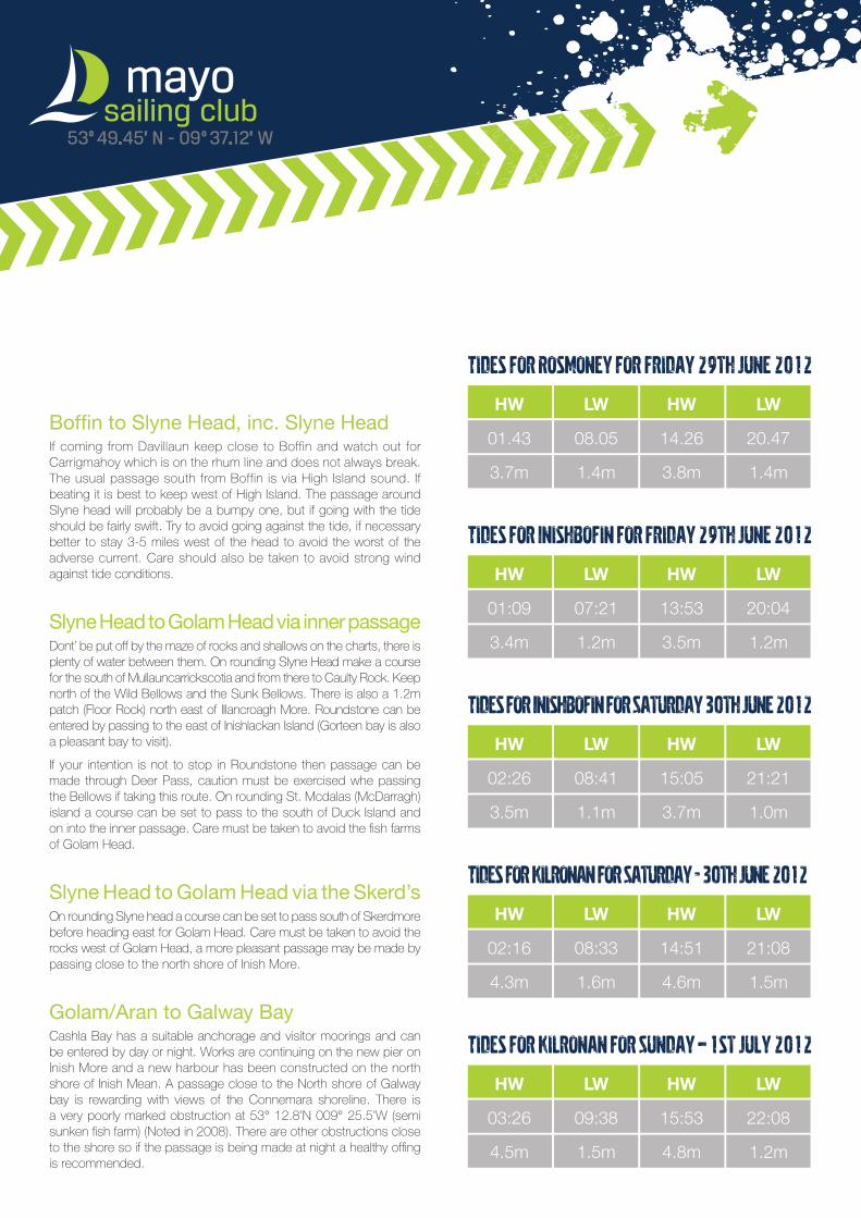
Tides for Rosmoney for Friday 29th June 2012
HW LW HW LW
01.43 08.05 14.26 20.47
3.7m 1.4m 3.8m 1.4m
Tides for Inishbofin for Friday 29th June 2012
HW LW HW LW
01:09 07:21 13:53 20:04
3.4m 1.2m 3.5m 1.2m
Tides for Inishbofin for Saturday 30th June 2012
HW LW HW LW
02:26 08:41 15:05 21:21
3.5m 1.1m 3.7m 1.0m
Tides for Kilronan for Saturday - 30th June 2012
HW LW HW LW
02:16 08:33 14:51 21:08
4.3m 1.6m 4.6m 1.5m
Tides for Kilronan for Sunday – 1st July 2012
HW LW HW LW
03:26 09:38 15:53 22:08
4.5m 1.5m 4.8m 1.2m
Slyne Head Currents are (Per ICC sailing directions): Northbound 2h before HW until 2h after HWSouthbound 4h after HW until 4h before HWSlack water is in the intervening times
From Inishbofin to Slyne Head is 14nm (this will take almost 3 hours at 5 knots). It is best to leave Inishbofin at 8.00 and be at Slyne Head at 11.00.It is another 40 nm to Kilronan (8 hours at 5 knots).
Time Direction of tide
06.30 Southbound
07.30 Southbound
08.30 LW at 08.30 Southbound
09.30 Southbound
10.30 Southbound
11.30 Slack Water
12.30 Slack Water
13.30 Slack Water
14.30 Northbound
15.30 HW at 15.00 Northbound
16.30 Northbound
17.30 Northbound
18.30
Tidal Gate at Slyne Head for trip to Galway Volvo Ocean Race Saturday June 30th 2012
Galway Tides
02.24 4.3m
08.31 1.3m
15.00 4.5m
21.08 1.2m
Mayo Sailing Club - Overview of Volvo Ocean Race week in Galway
Time10.00
12.00
14.00
16.00
18.00Overnight
Thurs Fri Sat Sun Mon Tues Wed Thurs Fri Sat Sun Jun-28 Jun-29 Jun-30 Jul-01 Jul-02 Jul-03 Jul-04 Jul-05 Jul-06 Jul-07 Jul-08
Leave GB12 GB12 Bofin (3 Races) (2 Races) before 8.00
VOLVO OCEAN RACE - PORT INFORMATION All MARINERS, SHIP OWNERS, FISHERMEN, YACHTSMEN, RNLI, GARDA WATER UNIT, IRISH NAVAL SERVICE, IRISH COAST GUARD, IRISH WATER SAFETY, CIVIL DEFENCE, GALWAY SUB AQUA CLUB, AND BOAT OWNERS.
Galway Harbour Company hereby gives notice that the safety of all while afloat during the Volvo Ocean Race Stopover at Galway is of prime importance. To this end you are reminded of the basic rules of on-water safety.
Captain Brian Sheridan Harbour Master & Pilotage Superintendent 22/06/2012
During your time at Galway the following is to be observed:
1. Use of your own vessel tender/dingy is prohibited to gain access to/from the shore from the swing moorings. Sailors wishing to land ashore during the stopover [30th June to 8th July 2012] from the swing moorings must do so by the approved water taxi service. The water taxi can be requested on VHF Channel 77 and will run from 09:00 hrs to 23:00 hrs excluding an hour either side of Low Water each day. There will be a charge for this service.
2. The wearing of lifejackets while at sea or in the harbour whilst manoeuvring is to be observed in accordance with SI 921 of 2005 -Pleasure Craft (PFD and Operations) (Safety) Regulations.
3. All craft while on the water in the bay area may be inspected by the Garda Water Unit in accordance with the Maritime Safety Act 2005, paying particular attention to lifejacket use, vessel seaworthiness, vessel insurance and alcohol abuse.
4. It is recommended that all craft find a suitable and safe anchorage to view the Pro Am Race In-Port Race to minimise the risk of collision due to the large number of visiting craft in that area.
5. Mariners are hereby given notice that under no circumstances shall any craft other than craft authorised and flying an appropriate official VOR Flag by the Harbour Master or Volvo
S.L.U. enter the buoyed marshal exclusion zone which encompasses the race course that the race marks will define. Marshal craft will be clearly identified with authorised flags to patrol the race exclusion area.
6. Other than event craft, rescue craft and craft authorised by the Harbour Master; owners/skippers are advised that the following speed restrictions exist in Galway Bay:
Inner Harbour <3 knots Shipping Channel <5 knots Shipping Channel to Black <20 knots Mid Bay - Blackrock to Black Head <25 knots
7. No overtaking is permitted in the shipping channel from the Leveret Lighthouse to the harbour [inbound and outbound craft].
8. All craft are to take instructions/directions from the harbour pilots/On-Water Manager as to manoeuvring in the harbour, particularly on the peak vessel movement dates for the Pro Am & In-Port Races.
9. All craft are to have due regard to visiting craft that are on swing moorings in the lee of the Mutton Island Causeway. Keep your speed to a safe speed when transiting this area and in no case faster than 5 knots.
10. Unless in an emergency situation, no craft is to enter the harbour under sail.
11. Vessel generated garbage can be landed to the shore side skips provided which are located at the Harbour.
12. Freshwater water is available at the marina and along the pier at the harbour office.
13. Electrical power is available on certain pontoons. No power facilities are available for craft moored alongside the quay wall or vessels rafted.
14. Limited showering facilities are available at North Dun Aengus Quay for visiting craft.
15. A limited refueling service will be available in the harbour when the dockgates are open. Please call Water Ops on VHF 66 between 08:00 - 09:30 (except on Prom Am and In-Port race Days) to make arrangements for booking and refueling time.
16. Waste oil facilities are available for visiting craft. This service is provided free of charge by the Galway Harbour Company. Contact Water Ops on VHF 66 for the for arrangement
17. Craft moored in the harbour are to be aware of the surrounding residential buildings and to keep noise levels to a respectable level. Owners will be removed from the harbour if co¬operation in this regard is not upheld.
18. Take heed of the location of the nearest lifebelts that are located around the harbour.
The Irish Coast Guard will continue to monitor the following VHF Channels on Galway Bay: Ch 16, 67, 04 & Digital Selective Calling DSC70.
GALWAY HARBOUR COMPANY
NOTICE TO MARINERS No. 1 of 2012
British Admiralty Chart No. 1904 & 1984
All MARINERS, SHIP OWNERS, FISHERMEN, YACHTSMEN, AND SHIP’S AGENTS
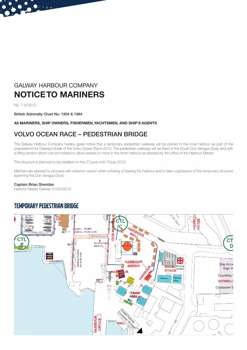
VOLVO OCEAN RACE – PEDESTRIAN BRIDGE The Galway Harbour Company hereby gives notice that a temporary pedestrian walkway will be placed in the inner harbour as part of the preparations for Galway’s finale of the Volvo Ocean Race 2012. The pedestrian walkway will be fixed at the South Dun Aengus Quay and with a lifting section which can be hoisted to allow vessels to moor in the inner harbour as advised by the office of the Harbour Master.
The structure is planned to be installed on the 27June until 10July 2012.
Mariners are advised to proceed with extreme caution when entering of leaving the harbour and to take cognisance of this temporary structure spanning the Dun Aengus Dock.
Captain Brian Sheridan Harbour Master Galway 31/05/2012
TEMPORARY PEDESTRIAN BRIDGE
GALWAY HARBOUR COMPANY
NOTICE TO MARINERSNo. 2 of 2012
British Admiralty Chart No. 1904 & 1984
All MARINERS, SHIP OWNERS, FISHERMEN, YACHTSMEN, AND SHIP’S AGENTS
VOLVO OCEAN RACE - PEDESTRIAN BRIDGE (RIVER CORRIB) The Galway Harbour Company hereby gives notice that a temporary pedestrian walkway will be placed over the River Corrib as part of the preparations for Galway’s finale of the Volvo Ocean Race 2012. The pedestrian walkway will be fixed at the Fishmarket Square and at the Canal Basin. Works will commence on Saturday 16June and are expected to be completed on 29June 2012. The pedestrian walkways will be removed after the event, commencing the week of July 9th 2012. See attached drawing.
Mariners are advised to proceed with extreme caution when navigating in the vicinity of the mouth of the river and are not permitted to navigate upstream of the Canal Basin lock gate. See Exclusion Zone on drawing.
Captain Brian Sheridan Harbour Master Galway 16/06/2012
TEMPORARY PEDESTRIAN Walkway Surface Craft to remain downstream of this exclusion zone.
1. Barna Pier
• Approach the eastern end of the pier in a northerly direction to avoid the off-lying Carraiganoge Rock on your stb.
• It is possible to anchor off the pier for a short time. • The pier is clean on the bottom but is a high climb when the boat dries out.
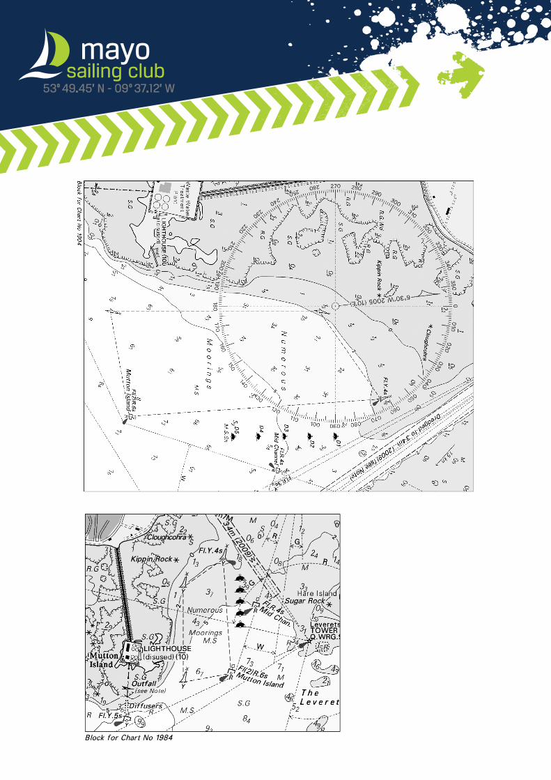
2. Galway Docks • Water between Mutton I. and Galway Docks is very shallow so don’t
go there. • Keep on the line - Leverets lighthouse (black/white striped tower) -
New Pier to avoid this shallow ground. • There are leading lights to guide into the docks from Leverets Lighthouse
3. Oranmore Bay • Possible to sail right up to Oranmore pier and castle, but only in the
right conditions: wind in the easterly half, and a big tide (teatime tide). • Easy sail to half-way in. Favour the south side until past Saleen. This
will avoid the pinnacle rock in mid channel. • South shore (North shore of Rinville) is steep-to and it is possible to
tack in quite close. • If attempting to go alongside the castle pier, approach it by turning in
a clockwise circle to avoid a low extension of the pier (not visible at high tide).
4. Saleen • Difficult to get into Saleen as there is a sand bar at its mouth. Need a
big tide and relatively shallow draft. Reverse in because there is not enough room to turn.
5. Rinville • When returning from e.g. Aran at night, head for Tawin buoy and then
Mutton buoy and head in towards Rinville from there. This will avoid Cockle Rock, marked N cardinal, light visible approx 1 mile.
• There is a bar across New Harbour (Rinville Bay). It lies in a line the headland just west of the club and Ardfry. Best passage is 1/3 headland and 2/3 Ardfry. At low water both sides of the bar are shoal, especially the south shore which also has rocks.
• It is possible to sail into the little bay NE of the Watchtower. However, make sure to avoid Clochnacohery. This is a reef with two pinnacle rocks. These lie in a NW direction from a very large obvious white rock on the south shore.
6. Cockle Rock • It is possible to pass inside Brendan’s Reef beyond half tide but keep
close to the shore. • Steer tower over Merlin Park hospital to clear Cockle from Kilcolgan
Pt. or Ballyvaugan
7. Mweeloon Bay • There is a bar across the entrance to Mweeloon bay. It is higher in
the middle so entry to the bay must be done at either side. Favour the northern side and stay close to the shore. (Watch for Ardfry Point which runs out a little bit in a west direction from the land.)
• It is possible to sail quite close to Ardfry House.
8. Kilcolgan Point• There are rocks off this Point. Keep 0.5 miles off the headland to avoid
the rocky headland. • Don’t cut into the south shore of the point until it is north of your
position - there is a pinnacle rock approx. ½mile SW of the point. • In rough conditions, it is advisable to give the Point a wide berth, i.e.
1 mile off, to avoid the isolated Kilcolgan Rock which is approx. 2/3
mile off the Point. The chart shows a depth over the rock of 3m but the seas might alter this height in the troughs.
9. Rincarna Bay• It is possible to tack quite close to Eddy I. and Mweenish I. • When sailing to Moran’s, sail along a line the eastern ruin on Eddy and the
pier at Carrowmore. (Pier presently identified near a large grey barn, 2001). This will avoid Mweenish point (to port) and Meelan Rock (to stb.).
• If entering the Ship Pool near HW, give Mweenish Pt a wide berth as there is a shingle spit running NW from the point.
• Further in, watch for Yellow Rock (off N shore)and the large reef to the south. Bird I. (small island) marks the eastern end of the reef, and a line North/South of Bird I means that both Yellow Rock and the reef are past.
• Possible to sail up the Clarin River to a large pier ½mile from Clarinbridge. Use a large tide.
• There is a bar across the entrance to the Kilcolgan River. To find the deepest part, stay close to the south shore.
• Going up the river, stay mid-channel. • Possible to get alongside the quay at Morans with 1.8m draft at HW
when HW is over 4.3m.
10. Kinvara• There are two rocks to watch for on the way into Kinvara Bay, they are
Cragnach and Goragh rocks north of Doorus Pt. It is possible to sail between them at HW on a transit west tip of Eddy I. in line with 50-100 yds east of Doorus Pt.
• To avoid Goragh rock, keep well off Doorus Pt until you are east of a transit Doorus Pt and the easterly ruin on Eddy I. Or…until you can see Parkmore pier inside Doorus.
• Then head towards Parkmore pier or the moorings off the pier. Keep away from the eastern shore (Belacoon Pt) as the ground is shoal.
• Next hazard is Long Rock which is on stb on the way in. (Bears 135deg true from Parkmore Pier.) Two transits can be used. There is a perch on Gormeen Rock and run on a line between the perch and the end of Parkmore pier. The second transit (courtesy of Dave Fitzgerald) is to keep a cream house which is visible down at Kinvara (on the Gort road) open to the left with the top of Dunguire castle. The top of the castle can be hard to spot!
• Go between the mussel rafts. • Avoid Gormeen rock with the perch and then stay mid channel until
close to the quay. • Keep 50-100 yds off the end of the pier until the whole the inside of
the quay is visible. This is to avoid some shallow rocks of the north and end of the pier.
• It is possible to anchor off. At LW springs, it is difficult to come ashore in a punt as the bay dries to mud around its edges and is very messy. This is not a problem at neaps.
11. Aughinish • It is possible to sail inside Deer Island spit near HW - but keep 1/3 or
less to shore and 2/3 or more to Deer I. • When heading for new Quay, beware of two rocks well off the north
shore. They lie SW of a church ruin on Aughinish. Favour the south shore as it is fairly steep-to.
• There is a very strong current in the narrows at New Quay. Bear this in mind as, in trying to keep the boat slow, you will loose steerageway.
• If wishing to go alongside at New Quay, then go in past the quay and then turn to stb to bring the boat back alongside. This will bring the boat out of the main flow. Good flat sandy bottom.
• In coming off the quay, maintain the stern warp until the bow has swung outside the pier.
Pilotage Notes - Galway Bay (compiled by John Preisler, 2002.)
(use at your own risk) Admiralty chart 1984 is required.
• There is a pool approx. 1 mile into Aughinish bay. It is difficult to get in to the pool as there is only a narrow channel with shoal ground (oyster beds) each side.
• I believe that it is possible to sail all the way up the bay to near Weir Island.
12. Bell Harbour. • For boats of draft 1.8m, Bell Harbour is only accessible ½hour either
side of HW, AND only when HW is over 5.3m. • On a slope running away from the entrance to Bell Harbour there
are three stone walls running from shore to brow of the hill. Near the middle one, there is a new bungalow. Approach the entrance to Bell harbour along the line of the middle wall.
• Keep running in until the depth starts to shoal and then turn to port to continue up the entrance to the harbour. If the turn to port is too soon, the likelihood is that the boat will go aground on the reef at the southerly end of Scanlan’s Island.
• After that, work your way in using the chart and the depth sounder until in the narrows between Finavarra and Muckinish .
• Then head towards the pier which becomes visible to port – to avoid the oyster bed. From there run towards the second quay. Turn just before reaching the second pier and head down mid channel.
• After the Pouldoody cliffs on port, run in towards the quay and turn to port to leave the quay astern. Follow the depths in towards the quay at the top of Bell harbour.
• Note that the quay will be difficult to see as it will either be only a few cm above the water, or will be just submerged.
13. Ballyvaughan • Head to the Margaretta Buoy to give a safe line to Finavarra Point. • Finavarra Point should not be cut too fine. Aim to keep 1-2 cables off. • Between 2 hours either side of HW it should be possible to steer for a
point between both the new pier (the one at Monks’ Pub) and the old pier. • Beware of Gall island, the eastern side of which shows near HW. This
is a reef which projects quite far out into the channel normally taken when heading for either piers. If only the end of the new pier, or the eastern side of the new pier is visible then bear to stb to avoid this reef. Do not confuse Gall I. with Green I. which is just to the north of it.
• It is possible to get as far as the pool off the old pier at ½tide by carefully navigating to find the deep channel to the east of the sands which extend north from the new pier. The trick is to get far enough to the east to avoid the finger of sand and then go looking for the channel.
• It is possible to anchor off the old pier but beware of large lobster traps floating just below the surface - they will be buoyed. It is not really feasible to tie up to the old pier.
Galway bay - The outer bay 14. Sruthan/Cashla bay (Admiralty chart 2096) • Sruthan at the head of Cashla bay is a good anchorage. Access at
all states and in all conditions is pretty straightforward as the channels are well marked. Both Cannon Rock and Coddu Rock at the mouth of the bay are visible.
• If approaching from the west, keep well off Killeen Pt on the west shore as a reef runs out quite a bit from there, i.e. Narien Spit.
• Do not turn port into Sruthan until past the last red buoy as there is an underwater reef there, and the buoy marks the end of it.
15. Greatman’s Bay. (Admiralty chart 2096) • It is possible to navigate up to the anchorage off Maumeen Quay
without any major difficulty, providing a chart is used. • Bear in mind that there can be up to 2 knots of tide running through the bay. • The first danger spot to watch out for are Rin rock which extends to
almost mid channel from Rin Point on the east shore. At the same time don’t go too close to the western shore here either is it is also foul.
• The second spot to watch is Chapel Rocks, approx. 0.7 mile further up. They lie in mid channel so head close towards either shore.
• The third spot to watch is Eragh Spit which extends up to 0.4miles SW (at HW) from Eragh Island on the eastern side of the bay.
• It is possible to navigate all the way up to Bealadangan Bridge, but great care must be taken.
16. To Roundstone from Galway (Admiralty chart 2096 and 2709) • In a SW wind take a long tack towards Black Head. Otherwise you will
find you will be making many small tacks to keep off the north shore. • Course to Golam Head is 270deg magnetic or 260deg True. • Obstructions before Golam Head are English Rock approx. ½mile
offshore between Greatman’s Bay and Kiggaul bay, and Dawsey’s Rock between Kiggaul Bay and Golam Head. If returning from Roundstone, the temptation is to round Golam and begin to pick up the course for Galway, 080 deg true. However this will bring the boat nicely over both of these rocks. It is worth giving almost a mile clearance off the north shore at these points.
• Golam Head is readily identifiable by the old watch tower on its highest point. The tower has two windows in it through which you will be able to see light from quite a distance.
• If heading for Roundstone, the Inner passage can be used, at considerable saving in time. However, a chart is essential. The charts which cover this area are 2096 (Golam/Greatman’s Bay) and 2079 (Roundstone and approaches).
• MacDara I. is the island visible furthest South, and is conical in shape. The safest passage is to leave MacDara I. to stb, and the Deer Island (beyond MacDara) to port.
• If the weather is reasonable, it is possible to pass through MacDara Sound. • Keep on a line south of MacDara to avoid running over the Carraigaview
rock. This is not easily visible from the SE but breaks. As the rock comes alongside it will become visible. Run another ½mile before turning in towards MacDara sound.
• Enter the Sound in a north/south direction to avoid the rocky shore around MacDara to the west and to avoid Fraghan rock off the rocky Wherroon Islands to the east.
• When the little beach in the cove of Macdara is well open then head towards the northeastern tip of MacDara to avoid the rest of the rocks around Wherroon.
• When at the north tip of MacDara, steer to avoid Lebros Rock which lies approx. 0.7 miles north of the NE tip of MacDara, i.e. either tack out or tack in towards Mace Head (identifiable by the radio tower on it).
• It is possible to go through the Straddle Pass (between Mason I. and Mweenish I.) but this requires very careful navigation.
• Head on up to Roundstone. • Note that there is a bar east-west across the mouth of Roundstone
bay and lies just south of Roundstone church spire. At low water springs there may be only 1.2-1.5 m of water here. Tend towards the eastern shore for maximum depth across the bar.
Parade of Sail BriefMeet off Black Rock at 16.30 (N53 14.0, W009 07.0) Bear in mind on your way to the area that the Multihull Catamaran Championships will be finishing racing at 4 pm and the Galway Hooker Traditional fleet will be racing up to 4.30.
It is our intention to be in a position to commence the Parade at 16.30 pm. This is the time signalled for the Hookers to finish. Safety should be the priority of each craft and always respect the other fella! The bay is big enough for all!
Here are the main pointers and timetable of the afternoonWe want the show to start on time so please co-operate with the water marshalls who will guide and assist us using RIBS. VHF channel 69 will be used so make sure somebody is listening.
Fleet A. It is intended to let the powerboat fleet of participating pleasure boats, RIBS fishing boats start first in an orderly fashion spaced out in single file. This fleet will be led by a blue Garda RIB positioned in the middle of the start area at 4.29 pm.
See summary of abbreviated plan which will be repeated and also displayed at GBSC headquarters in marquee at docks and repeated on Volvo web site.
Fleet B. Yachts in ascending size should then be ready to start immediately after the powerboat fleet. We are expecting approx. 35 yachts to sail in from Aran, many coming from Westport so give them all a big welcome. Let’s split up the fleet somewhat but biggest craft should lead the way. (Why? - because at the other end, biggest craft will come alongside the Marina first in the Dock) This fleet will make their way inshore to Salthill along the Prom and around Mutton Island. See abbreviated plan.
Fleet C. This fleet comprises of craft up to 4 metres, sailboards, currachs, dinghies and canoes. These should assemble near the diving tower at Salthill for 4.30. Keep outside the swimming area. As soon as the yacht fleet approach you can move off down the Prom and follow the fleet.
Fleet D. The Galway Hooker Fleet should assemble after the last boat is finished racing in an area between Galway Bay Hotel and Seapoint. From here make your way towards the Docks ahead of the yacht fleet.
Fleet E. The Junior Parade of Sail will be ready to launch at the Ocean Sports Club from 4 pm and on the water at 4.30. Contact Conor Lyons. And will join the approaching fleet.
SAIL PAST. 17.00 hours. A suitable yacht dressed overall will be moored off Nimmos Pier to welcome the fleet with some dignatories on board to welcome you so be sure to make some noise. As the fleets converge on the docks we all must slow down and some may be asked to wait outside while the larger craft are berthing. Speed limit. Per marine notice is 5knots in shipping channel and 3 knots in harbour area. As you enter the dock, the Mayo boys and Marina Berth holders should go left. The Hookers go straight ahead along the dockgate quay and the rest will go right tieing up at the Volvo 70’s berths.
This will be a mammoth task to get all boats in so please have sails down when you come close and make sure your mooring lines are ready. Again there will be a number of RIB marshalls to assist berthing and make sure you can be heard. This all sounds fantastic but remember the weather is everything so I hope you all have a great day with your family and friends. Remember, consider each other and you will all make it.
Don’t forget your lifejacket!
The Volvo Ocean Race Finale is going to be a brilliant week for all boat enthusiasts and we owe a great debt of thanks to John Killeen and Enda O’Coineen as well as our Harbour Master Capt. Brian Sheridan for getting the town moving so do your stuff and get out on the water next Sunday 1st July.
For Galway Afloat.
Pierce Purcell - Parade of Sail co-ordinator
Committee. P. Purcell, David Vinnell – on the water Manager, Captain Brian Sheridan, Enda O’Coineen, Padraig de Bhaldraithe, Galway Hooker Ass., Rory Casey Mayo Yacht Club and Pierce (jnr) and Mark Purcell – Water Marshalls.