714 MEETING OF THE EXECUTIVE COMMITTEE #7/09 September 11, 2009 The Executive Committee Meeting #7/09, was held in the Victoria Room, Black Creek Pioneer Village, on Friday, September 11, 2009. The Chair Gerri Lynn O'Connor, called the meeting to order at 9:40 a.m.. PRESENT Maria Augimeri Vice Chair David Barrow Member Jack Heath Member Colleen Jordan Member Ron Moeser Member Gerri Lynn O'Connor Chair Maja Prentice Member Richard Whitehead Member ABSENT Glenn De Baeremaeker Member Suzan Hall Member Reenga Mathivanan Member Anthony Perruzza Member RES . # B 110/09 - MINUTES Moved by: Maja Prentice Seconded by: Richard Whitehead THAT the Minutes of Meeting #6/09, held on August 7, 2009, be approved. CARRIED _________________________________________ DELEGATIONS (a) A delegation by Mr. Frank Lancia, resident, City of Vaughan, in regard to item 7.2 - Request for Disposal of Toronto and Region Conservation Authority-Owned Land, Royalpark Way and Panorama Crescent.
Transcript
714
MEETING OF THE EXECUTIVE COMMITTEE #7/09September 11, 2009
The Executive Committee Meeting #7/09, was held in the Victoria Room, Black Creek Pioneer Village, on Friday, September 11, 2009. The Chair Gerri Lynn O'Connor, called the meeting to order at 9:40 a.m..
PRESENTMaria Augimeri Vice ChairDavid Barrow MemberJack Heath MemberColleen Jordan MemberRon Moeser MemberGerri Lynn O'Connor ChairMaja Prentice MemberRichard Whitehead Member
ABSENTGlenn De Baeremaeker MemberSuzan Hall MemberReenga Mathivanan MemberAnthony Perruzza Member
RES.#B110/09 - MINUTES
Moved by: Maja PrenticeSeconded by: Richard Whitehead
THAT the Minutes of Meeting #6/09, held on August 7, 2009, be approved. CARRIED
_________________________________________
DELEGATIONS
(a) A delegation by Mr. Frank Lancia, resident, City of Vaughan, in regard to item 7.2 - Request for Disposal of Toronto and Region Conservation Authority-Owned Land, Royalpark Way and Panorama Crescent.
715
(b) A delegation by Mr. Paul Giusto, resident, City of Vaughan, in regard to item 7.2 - Request for Disposal of Toronto and Region Conservation Authority-Owned Land, Royalpark Way and Panorama Crescent.
RES.#B111/09 - DELEGATIONS
Moved by: Maja PrenticeSeconded by: Ron Moeser
THAT above-noted delegations (a) and (b) be heard and received.CARRIED
_________________________________________
SECTION I - ITEMS FOR AUTHORITY ACTION
RES.#B112/09 - REQUEST FOR DISPOSAL OF TORONTO AND REGION CONSERVATION AUTHORITY-OWNED LANDRear of Various Residential Properties along Royalpark Way and Panorama Crescent, East of Regional Road 27, south of Rutherford Road, CFN 40996. Toronto and Region Conservation Authority (TRCA) is in receipt of requests from 16 residential property owners to explore the possibility of a sale of fragments of TRCA-owned land located directly behind 6, 10, 14, 16, 20, 24, 26, 28, 30, 34, 36, 40, 42, 46, 50 and 52 Royalpark Way, and 5 properties owner along Panorama Crescent, City of Vaughan, Regional Municipality of York, Humber River watershed.
Moved by: Maja PrenticeSeconded by: David Barrow
THE EXECUTIVE COMMITTEE RECOMMENDS THAT the Toronto and Region Conservation Authority (TRCA) land located directly behind 6, 10, 14, 16, 20, 24, 26, 28, 30, 34, 36, 40, 42, 46, 50 and 52 Royalpark Way, City of Vaughan, Regional Municipality of York, be retained for conservation purposes;
THAT the TRCA land directly behind 40, 44, 46, 48, 50 and 52 Panorama Crescent, City of Vaughan, Regional Municipality of York, be retained for conservation purposes;
AND FURTHER THAT TRCA staff be directed to arrange for the removal of any remaining encroachments at these two locations.
CARRIEDBACKGROUNDA request was received on October 28, 2008 from Councillor Tony Carella (Ward 2 - City of Vaughan) on behalf of 16 residential property owners along Royalpark Way, requesting the sale of fragments of TRCA land situated east of Regional Road 27, south of Rutherford Road, for additions to their residential properties.
At Executive Committee Meeting #10/08, held on December 12, 2008, Resolution #B162/08 was approved as follows:
716
THAT the potential disposal of fragments of Toronto and Region Conservation Authority (TRCA)-owned land located directly behind 6, 10, 14, 16, 20, 24, 26, 28, 30, 34, 36, 40, 42, 46, 50 and 52 Royalpark Way, City of Vaughan, Regional Municipality of York, be referred to TRCA staff for review and discussion in accordance with established TRCA policies;
AND FURTHER THAT a report be brought forward to the Executive Committee at a future date recommending further action.
The 16 residential property owners were encroaching on TRCA land , which was acquired by TRCA through the subdivision process. The encroachments consist of the removal of vegetation; the dumping of grass clippings, excavated fill material, etc.; planting of vegetable gardens / trees; stored piles of timber, stones, rocks, concrete, etc.; placement of children's playground equipment/swing sets; construction of garden sheds; and mowing of natural ground cover. In 2008, letters were sent to each landowner, requiring removal of structures, stored material, etc. and indicating that TRCA property was not to be disturbed any further and left to naturalize. With the exception of one garden shed, all structural encroachments have been removed from TRCA property. At the request of this property owner, staff agreed not to pursue the removal of the shed until the review of this sale request had been finalized. Some of the owners continue to mow the native ground cover and plant vegetable gardens on these TRCA lands.
The TRCA valleylands in this vicinity were acquired from Ivy Green Homes Inc. and Queens Gardens Holdings Inc. on November 27, 1998 under the "Greenspace Protection and Acquisition Project 1996-2000", Flood Plain and Conservation Component, Humber River watershed.
As per TRCA's disposal policy, this request was circulated to City of Vaughan and Regional Municipality of York staff as well as TRCA staff for review and comment. The following comments have been received:
City of Vaughan staff City of Vaughan Planning Department has no objection to the proposed disposition. However, no buildings or structures other than for conservation or flood control projects would be permitted within the OS1 Open Space Conservation Zone. In addition, the OS1 zoned lands would not be used in calculating the lot frontage, lot area, coverage or yards required by the City's Comprehensive By-law. The Planning Department staff's preference would be to avoid a split zone situation and rezone the OS1 Open Space Conservation Zone to an R4 Residential Zone.
Regional Municipality of York staff The Regional Municipality of York Property Services Branch has no objection to the proposed sale of the subject lands.
TRCA staff Planning and Development staff does not support the request for disposal of TRCA lands at this location for the following reasons:
717
As part of the review and approval of residential subdivision 19T-89047 (known as Ivy Green Homes Inc.) and at the request of TRCA staff at that time, a geotechnical report was prepared that identified six (6) active erosion zones along the Humber River which traverse the open space block of this subdivision. One of the identified erosion zones was found to have a potential impact on areas directly behind several lots subject to this disposal request. It would therefore be prudent to ensure the continued protection of the lots from the identified erosion hazard by not allowing homeowners to encroach into these potentially problem areas. Through the acquisition of the valley lands and the substantial review of geotechnical investigations, a significant amount of time and effort has been spent by staff to ensure the long term protection of this reach of the East Humber River from an ecological and erosion hazard perspective.
The Valley and Stream Corridor Management Program (VSCMP) sets out the Program Framework for TRCA. One of the principles in the VSCMP states: "the successful management of valley and stream corridors is dependent on good tableland management". Removing lands that are considered to be buffers does not meet the notion of good tableland management. Additionally, the VSCMP defines the limits of stream/valley corridors to include a minimum of 10 metres inland from the top of valley bank, provided that the stream or valley is in a stable condition. In the case of this subdivision, the erosion prone lands along the Humber River have been engineered and streambank erosion measures have been constructed to protect both the valley corridor and the adjacent residential properties. However, in the event of failure of the erosion protection, the valley's natural stable top of slope and requisite 10 metre tableland buffer would likely be located within the area proposed to be acquired by the neighbouring residential properties.
Lastly, as part of day-to-day negotiations with the development industry and private property owners, staff always endeavors to obtain a buffer for the protection of ecological features/stream and valley corridors as well as to protect private lands. Therefore, the approval of this request would be contrary to TRCA's VSCMP policies as well as TRCA's mandate to conserve natural areas and protect adjacent lands from natural hazards.
Panorama CrescentIn addition to the request for disposal of TRCA land by the Royalpark Way residents, staff has also received an identical request from the owners along Panorama Crescent who have also encroached on TRCA property behind their rear lot boundaries. Panorama Crescent is located along the same reach of the East Humber River valley corridor (Attachment 1). The owners of 40, 44, 46, 48, 50, and 52 Panorama Crescent are seeking to acquire TRCA tableland behind their respective lots.
As in the case of resolving the Royalpark Way encroachments, staff has been successful in convincing most of the Panorama Crescent landowners to remove the majority of structural encroachments, with the exception of one garden shed; however, mowing of natural ground cover and the planting of vegetable gardens still persists. The TRCA lands behind the properties on Panorama Crescent were acquired by the same transaction as the TRCA lands behind Royalpark Way. In addition, the same geotechnical report, corrective recommendations and streambank erosion protection was completed behind this portion of Panorama Crescent.
718
TRCA's Planning and Development staff has also reviewed this request and the comments relating to Royalpark Way also apply to Panorama Crescent.
RATIONALEIt is staff's opinion that the acquisition and retention of tableland buffers are essential to the protection of the ecological features/functions of stream and valley corridors as well as provide additional protection to abutting private lands, particularly those situated in erosion prone locations. The lack of tableland buffers has resulted in substantially greater risks to private properties and human habitation and the potential for costly remediation projects as is presently being experienced in the case of the Royal Rouge Trail and Troutbrooke Drive erosion sites.
Report prepared by: George Leja, extension 5342Emails: [email protected] Information contact: George Leja, extension 5342; Ron Dewell, extension 5245Emails: [email protected]; [email protected]: August 12, 2009Attachments: 1
719
Attachment 1
_________________________________________
720
RES.#B113/09 - GREENLANDS ACQUISITION PROJECT FOR 2006-2010Flood Plain and Conservation Component, Rouge River WatershedPurchase of Land - Shirley Klees, CFN 38959. Acquisition of land located on the north side of Stouffville Road, east of Bayview Avenue, Town of Richmond Hill, Regional Municipality of York, under "Greenlands Acquisition Project for 2006-2010,” Flood Plain and Conservation Component, Rouge River watershed.
Moved by: David BarrowSeconded by: Jack Heath
THE EXECUTIVE COMMITTEE RECOMMENDS THAT 16.14 hectares (39.3349 acres), more or less, of vacant land being Part of Lots 1 and 2, Concession 2, Town of Richmond Hill, Regional Municipality of York, located on the north side of Stouffville Road, east of Bayview Avenue be purchased from Shirley Klees;
THAT the purchase price be $1,360,000;
That acquisition of this property by Toronto and Region Conservation Authority (TRCA) be conditional on all necessary funding being available from one or more of the following sources: Regional Municipality of York, Town of Richmond Hill, City of Toronto and other potential funding sources;
THAT TRCA receive conveyance of the land free from encumbrance, subject to existing service easements;
THAT the firm of Gardiner Roberts LLP, Barristers and Solicitors, be instructed to complete the transaction at the earliest possible date. All reasonable expenses incurred incidental to the closing for land transfer tax, legal costs and disbursements are to be paid;
AND FURTHER THAT authorized TRCA officials be directed to take whatever action may be required to give effect thereto, including the obtaining of necessary approvals and the signing and execution of any documents.
CARRIEDBACKGROUNDResolution #A260/05 at Authority Meeting #9/05, held on November 25, 2005, approved the Greenlands Acquisition Project for 2006-2010.
In the late 1990's the Rouge Park Alliance/TRCA developed a Pool of Priority Sites for Acquisition and included in the list was the Jefferson Forest Environmentally Significant Area (ESA) and the Provincial Life Science Area of Natural and Scientific Interest (ANSI) called the Wilcox Lake Wetlands and Uplands, in an area approximately bounded between Bayview Avenue and Leslie Street, north of Stouffville Road and south of Bethesda Road. This is considered to be an important headwaters area for the Rouge River. In February 2001, the first property in the area, a 46 acres property, 940 Stouffville Road, was purchased by TRCA with funding assistance from the Town of Richmond Hill, the Regional Municipality of York and the Province of Ontario.
721
In May 2001, the Oak Ridges Moraine Protection Act, 2001 froze all development applications on the moraine including an area referred to as Yonge East and West in the Town of Richmond Hill (Oak Ridges Corridor Park - herein "Corridor Park"). On September 23, 2004, the Minister of Municipal Affairs and Housing announced that the Province of Ontario and certain landowners on the Oak Ridges Moraine in the Town of Richmond Hill had reached an agreement to exchange lands. The purpose of the land exchange was to protect the last remaining natural corridor link between the eastern and western parts of the Oak Ridges Moraine in Richmond Hill. Under the agreement, 1,057 acres (428 hectares) of land in Richmond Hill would come into public ownership. The Province completed the land exchange in August 2007, and became owners of the Oak Ridges Corridor Park. Approximately 120 acre of the 1,057 acre Corridor Park is found in the Jefferson Forest ESA east of Bayview, (Corridor Park East).
In addition to the corridor park lands an opportunity arose for the Province to secure and protect additional adjacent lands in public ownership within the Corridor Park East area. Through this process TRCA acquired 269 acres within the Corridor Park East.
Another important part of the Corridor Park East land assembly, 900 Stouffville Road, a 25 acre parcel, was acquired in 2006, through a partnership involving the Regional Municipality of York, the Town of Richmond Hill, City of Toronto and the Oak Ridges Moraine Foundation. In 2008, the Swan Lake property which is the second last remaining large parcel in Corridor Park East was acquired though a partnership involving the Regional Municipality of York, the Town of Richmond Hill, City of Toronto, the Oak Ridges Moraine Foundation, Ducks Unlimited Canada and the EJLB Foundation. This raised the total land owned by TRCA in Corridor Park East to 392 aces and the total Corridor Park to 1,449 acres (provincial lands plus TRCA lands). This acreage does not include TRCA=s Lake St. George property or Town of Richmond Hill park lands.
RATIONALEThe subject property is the only remaining large parcel to be acquired to complete the Corridor Park East land assembly and will be a key link to other public lands. Staff is recommending that TRCA acquire it.
The agreement is conditional on the availability of funding. The offer at hand is supported by an appraised value based on an independent valuation.
Negotiations have been conducted with the owner.
Attached is a plan showing the location of the subject lands.
The subject property falls within TRCA's approved master plan for acquisition for the Rouge River watershed as outlined in the approved Greenlands Acquisition Project for 2006-2010. The subject property is also included in the Pool of Priority Acquisition Sites for the Rouge Park approved by the Rouge Park Alliance.
722
It is located in the headwaters of the Rouge River, in the provincially significant Wilcox Lake and Uplands Area of Natural and Scientific Interest and within the Jefferson Forest Environmentally Significant Area (ESA#90). The property is designated as Natural Core Area under the Oak Ridges Moraine Conservation Plan. The addition of the subject parcel will compliment TRCA's holdings in this area.
TAXES AND MAINTENANCESince this property has been designated as a provincially significant ANSI it will be eligible to receive a property tax exemption. TRCA, together with other stakeholders including the Town of Richmond Hill, Regional Municipality of York and Ontario Realty Corporation are currently preparing a management plan for the Corridor Park East lands. The subject property will be included in this process.
FINANCIAL DETAILSThe subject property was identified on the list of properties approved by the City of Toronto to be funded from the City's Land Acquisition for Source Water Protection Reserve. The City will fund up to 33% of the costs of the acquisition for properties on the list located outside of the city boundaries.
Town of Richmond Hill and Regional Municipality of York staff have indicated during preliminary discussions that they would support a contribution to this purchase. Other potential funding sources are The Conservation Foundation of Greater Toronto, other foundations and the TRCA land sale reserve. Expenditures related to this acquisition will be charged to account 004-11-502.
Report prepared by: Dan O'Donohue, Senior Property Agent and Michael Fenning, Manager Acquisition and SalesEmails: @trca.on.caFor Information contact: Dan O'Donohue, extension 5767 and Michael Fenning, Extension 5223Emails: do'[email protected], [email protected]: August 21, 2009Attachments:1
723
Attachment 1
_________________________________________
724
RES.#B114/09 - GREENLANDS ACQUISITION PROJECT FOR 2006-2010Flood Plain and Conservation Component, Humber River WatershedSugarberry Holdings Inc., CFN 42800. Purchase of property located east of Pine Valley Drive, south of Major Mackenzie Drive, City of Vaughan, Regional Municipality of York, under the "Greenlands Acquisition Project for 2006-2010", Flood Plain and Conservation Component, Humber River watershed.
Moved by: Ron MoeserSeconded by: Colleen Jordan
THE EXECUTIVE COMMITTEE RECOMMENDS THAT 0.22 hectares (0.54 acres), more or less, of vacant land being Part of Lot 19, Concession 6 and designated as Block 244 on a draft Plan of Subdivision, prepared by Guido Papa Surveying Ltd., under their Reference No. 06-541, dated October 14, 2008, City of Vaughan, Regional Municipality of York, located east of Pine Valley Drive, south of Major Mackenzie Drive, be purchased from Sugarberry Holdings Inc.;
THAT the purchase price be $2.00;
THAT Toronto and Region Conservation Authority (TRCA) receive conveyance of the land free from encumbrance, subject to existing service easements;
THAT the firm of Gardiner Roberts LLP, Barristers & Solicitors, be instructed to complete the transaction at the earliest possible date. All reasonable expenses incurred incidental to the closing for land transfer tax, legal costs, and disbursements are to be paid;
AND FURTHER THAT authorized TRCA officials be directed to take whatever action may be required to give effect thereto, including the obtaining of necessary approvals and the signing and execution of any documents.
CARRIEDBACKGROUNDResolution #A260/05 at Authority Meeting #9/05, held on November 25, 2005, approved the Greenlands Acquisition Project for 2006-2010.
Negotiations have been conducted with Mr. Marco Marcante, Land Development Manager, of Sugarberry Holdings Inc..
Attached is a plan showing the location of the subject lands.
RATIONALEThe subject property falls within TRCA's approved master plan for acquisition for the Humber River watershed as outlined in the approved Greenlands Acquisition Project for 2006-2010. Through the review of subdivision 19T-97V19 for proposed residential development of this site, TRCA staff established the limits of the open space lands (i.e. Block 244 on draft Plan of Subdivision) which is comprised of a portion of the valley corridor of a tributary of the East Humber River at this location.
725
TAXES AND MAINTENANCEBased on TRCA's preliminary review of the environmental criteria for lands that are eligible to receive a property tax exemption under the Provincial Conservation Land Tax Incentive Program, it would appear that all of the subject property would be eligible for exemption for the 2010 taxation year. The addition of the subject parcel of land will not significantly impact TRCA's maintenance costs at this location.
FINANCIAL DETAILSFunds for the costs related to this purchase are available in the TRCA land acquisition capital account.
Report prepared by: George Leja, extension 5342Emails: [email protected] Information contact: George Leja, extension 5342; Ron Dewell, extension 5245Emails: [email protected]; [email protected]: August 18, 2009Attachments: 1
726
Attachment 1
_________________________________________
727
RES.#B115/09 - GREENLANDS ACQUISITION PROJECT FOR 2006-2010Flood Plain and Conservation Component, Duffins Creek Watershed4324404 Canada Inc., CFN 42844. Purchase of property located on the south side of Bayly Street, east of Church Street (adjacent to 777 Bayly Street), Town of Ajax, Regional Municipality of Durham, under the "Greenlands Acquisition Project for 2006-2010", Flood Plain and Conservation Component, Duffins Creek watershed.
Moved by: Ron MoeserSeconded by: Colleen Jordan
THE EXECUTIVE COMMITTEE RECOMMENDS THAT 4.21 hectares (10.41 acres), more or less, of vacant land being Part of Lot 14, Range 3, Broken Front Concession and designated as Part 10 on a draft Plan of Survey, prepared by Donevan Fleischmann Petrich Ltd., Ontario Land Surveyors, under their Job No. 2009-034-2, received August 11, 2009, Town of Ajax, Regional Municipality of Durham, located on the south side of Bayly Street, east of Church Street (adjacent to 777 Bayly Street), be purchased from 4324404 Canada Inc.;
THAT the purchase price be $2.00;
THAT Toronto and Region Conservation Authority (TRCA) receive conveyance of the land free from encumbrance, subject to existing service easements;
THAT the firm of Gardiner Roberts LLP, Barristers & Solicitors, be instructed to complete the transaction at the earliest possible date. All reasonable expenses incurred incidental to the closing for land transfer tax, legal costs, and disbursements are to be paid;
AND FURTHER THAT authorized TRCA officials be directed to take whatever action may be required to give effect thereto, including the obtaining of necessary approvals and the signing and execution of any documents.
CARRIEDBACKGROUNDResolution #A260/05 at Authority Meeting #9/05, held on November 25, 2005, approved the Greenlands Acquisition Project for 2006-2010.
Negotiations have been conducted with Mr. David Carreiro, Regional Director, of First Industrial Realty, Inc., who acts as agent on behalf of the owner.
Attached is a plan showing the location of the subject lands.
RATIONALEThe subject property falls within TRCA's approved master plan for acquisition for the Duffins Creek watershed as outlined in the approved Greenlands Acquisition Project for 2006-2010. Through the review of severance application LD 014/2009 for proposed industrial development of this site, TRCA staff established the limits of the open space lands (i.e. Part 10 on draft Plan of Survey) which is comprised of a portion of the valley corridor of the Duffins Creek at this location.
728
TAXES AND MAINTENANCEBased on TRCA's preliminary review of the environmental criteria for lands that are eligible to receive a property tax exemption under the Provincial Conservation Land Tax Incentive Program, it would appear that a portion of the subject property presently zoned as Environmental Protection (EP) would be eligible for exemption for the 2010 taxation year. Staff is requesting that the other part of the open space lands to be acquired, which are currently zoned as General Employment, be re-zoned to the EP category in order to accurately reflect the ecological feature/use of the valley corridor so that the entire lands subject to the transfer will qualify for the property tax exemption. The addition of the subject parcel of land will not significantly impact TRCA's maintenance costs at this location.
FINANCIAL DETAILSFunds for the costs related to this purchase are available in the TRCA land acquisition capital account.
Report prepared by: George Leja, extension 5342Emails: [email protected] Information contact: George Leja, extension 5342 or Ron Dewell, extension 5245Emails: [email protected] or [email protected]: August 18, 2009Attachments: 1
729
Attachment 1
_________________________________________
730
RES.#B116/09 - CITY OF TORONTORequest for a Permanent Easement for a Stormwater Outfall and Plunge Pool/WetlandDon River Watershed, City of Toronto (North York Community Council Area), CFN 42851. Receipt of a request from the City of Toronto to provide a permanent easement for the construction of a stormwater outfall and plunge pool/wetland, south of Steeles Avenue, east of Dufferin Street (adjacent to 1755 Steeles Avenue), Don River watershed, City of Toronto (North York Community Council Area).
Moved by: Ron MoeserSeconded by: Colleen Jordan
THE EXECUTIVE COMMITTEE RECOMMENDS THAT WHEREAS Toronto and Region Conservation Authority (TRCA) is in receipt of a request from the City of Toronto to provide a permanent easement for a stormwater outfall and plunge pool/wetland, south of Steeles Avenue, east of Dufferin Street (adjacent to 1755 Steeles Avenue), Don River watershed, City of Toronto (North York Community Council Area);
WHEREAS it is in the best interest of TRCA in furthering its objectives as set out in Section 20 of the Conservation Authorities Act to cooperate with the City of Toronto in this instance;
THEREFORE LET IT BE RESOLVED THAT a permanent easement containing a total of 0.12 hectares (0.30 acres), more or less, be granted to the City of Toronto for a stormwater outfall and plunge pool/wetland, said land being south of Steeles Avenue, east of Dufferin Street (adjacent to 1755 Steeles Avenue), City of Toronto (North York Community Council Area), as shown on a Topographic Plan of Survey of Sanofi Pasteur Canada, prepared by Speight, Van Nostrand & Gibson Ltd., Ontario Land Surveyors, under their Job No. 061-0270, dated September 12, 2006;
THAT consideration be the nominal sum of $2.00, plus all legal, survey and other costs to be paid by the City of Toronto;
THAT the City of Toronto is to fully indemnify TRCA from any and all claims from injuries, damages or costs of any nature resulting in any way, either directly or indirectly, from the granting of this easement or the carrying out of construction;
THAT an archaeological investigation be completed, with any mitigative measures being carried out to the satisfaction of TRCA staff, at the expense of the City of Toronto;
THAT all TRCA lands disturbed by the proposed works be revegetated/stabilized following construction and, where deemed appropriate by TRCA staff, a landscape plan be prepared for TRCA staff review and approval in accordance with existing TRCA landscaping guidelines;
THAT a permit pursuant to Ontario Regulation 166/06 be obtained prior to commencement of construction;
731
THAT the granting of this easement is subject to receipt of written approval from the City of Toronto Parks, Forestry and Recreation Department who manage these lands on behalf of TRCA;
THAT said easement be subject to approval of the Minister of Natural Resources in accordance with Section 21(2) of the Conservation Authorities Act, R.S.O. 1990, Chapter C.27, as amended;
AND FURTHER THAT authorized TRCA officials be directed to take whatever action may be required to give effect thereto, including the obtaining of necessary approvals and the signing and execution of any documents.
CARRIEDBACKGROUNDThe City of Toronto has formally requested a permanent easement for the construction of a stormwater outfall and plunge pool/wetland, south of Steeles Avenue, east of Dufferin Street (adjacent to 1755 Steeles Avenue). The Sanofi Pasteur Connaught Campus has prepared a Master Stormwater Management Report to identify the quality and quantity impacts of the change in stormwater run-off on existing infrastructure and watercourses as a result of new buildings/additions under construction, as well as future re-development at the south end of the subject property. At Executive Committee Meeting #6/09, held on August 7, 2009, approval of Phase 1 of the stormwater management scheme, as reviewed and accepted by TRCA staff, was received for all proposed works on the tableland portion of the site, outside of TRCA property. Phase 2 of the project includes a new single stormwater outfall and plunge pool/wetland to be constructed on the adjacent valley lands owned by TRCA.
The stormwater outfall and plunge pool/wetland will be located within the Regional Storm Flood Plain and Regulated Area of the West Don River. A permit application pursuant to Ontario Regulation 166/06 for construction of the Phase 2 works will be scheduled at a future Executive Committee meeting.
The subject TRCA-owned lands were acquired from the Governing Council of the University of Toronto on September 28, 1972 under the Finch (a.k.a. G. Ross Lord) Dam and Reservoir Land Acquisition Project.
PlantingsAll lands disturbed by construction will be stabilized and, where deemed appropriate by TRCA staff, revegetated with native woody and herbaceous plant material in accordance with existing TRCA landscaping guidelines. A landscape plan will be prepared and form part of the permit pursuant to Ontario Regulation 166/06.
A plan illustrating the permanent easement location is attached.
732
FINANCIAL DETAILSThe City of Toronto has agreed to assume all legal, survey and other costs involved in completing this transaction.
Report prepared by: George Leja, extension 5342Emails: [email protected] Information contact: George Leja, extension 5342 or Ron Dewell, extension 5245Emails: [email protected] or [email protected]: August 18, 2009Attachments: 1
733
Attachment 1
_________________________________________
734
RES.#B117/09 - EROSION CONTROL MONITORING AND MAINTENANCE PROGRAMProposed Policy Revision. Update on the Erosion Control Monitoring and Maintenance Program, and amendment to policy regarding cost-sharing agreements for benefiting landowners.
Moved by: Ron MoeserSeconded by: Colleen Jordan
THE EXECUTIVE COMMITTEE RECOMMENDS THAT Toronto and Region Conservation Authority's (TRCA) policy regarding the contributions by private property owners towards valley and shoreline regeneration works as set out in Resolution #71/81, and confirmed in Resolution #A91/98 be revised by deleting clause (c) and substituting the following:
(c) Where agreement to policy (b) cannot be achieved, the benefiting owner(s) will be assessed 100% of the cost of the works.
CARRIEDBACKGROUNDAt Executive Committee Meeting #5/09, held on July 10, 2009, members directed staff to report back on TRCA's Erosion Control Monitoring and Maintenance Program to gain an understanding of the ranking process.
The primary goal of the TRCA Erosion Control Monitoring and Maintenance Program is to minimize risk to life and property as a result of the erosion of riverbanks, valley walls and shorelines while protecting and enhancing the natural attributes of the riverine valleys and Lake Ontario shoreline within the TRCA jurisdiction. This goal is derived from the objectives of the Conservation Authorities Act (1946), whereby conservation authorities are responsible for the development and maintenance of programs for the protection of life and property from natural hazards such as flooding and erosion.
TRCA adopted the Streambank Erosion Control Program in 1966 as a means of carrying out remedial works upstream of proposed reservoirs on public and private lands in an effort to reduce the amount of siltation occurring and to improve fish habitat in the watersheds. This program entailed the identification of erosion sites, monitoring the rate of erosion at these sites, and the implementation of erosion control works as required to reduce the amount of siltation occurring as the result of ongoing erosion. This program also included a monitoring protocol for structures built to ensure the ongoing effectiveness and integrity of the structures and to identify maintenance needs.
In 1972 the City of Toronto, in partnership with TRCA, adopted a policy and associated funding program to address erosion control and bank stabilization. Between 1972 and 1977 the program evolved to include the protection of public infrastructure, parklands, recreational trails, and residential dwellings threatened by bank erosion and slope instability issues arising from historic planning and development decisions. Similar policies were adopted by the regional municipalities of Durham, Peel and York in 1977.
735
The adoption of the Valley and Stream Corridor Management Program in 1994 marked a significant step forward by TRCA to reduce the amount of new development occurring within erosion prone areas in the jurisdiction. This document represents the amalgamation of a number of updated planning policies, including the introduction of designated valleyland corridors from which setbacks be required and adhered to, and creating greenspace between developed parcels of land and environmentally significant areas. This program specifically promoted the establishment of a standard 10 metre buffer between long-term stable slope crests and the proposed development area, thereby ensuring that new residential and commercial structures, as well as public infrastructure, are protected from natural erosion processes.
Erosion Control Monitoring and Maintenance ProgramThe Erosion Control Monitoring and Maintenance Program is responsible for the annual monitoring of over 350 erosion control structures and 40 erosion sites on public and private valley lands, approximately 42 kilometres of Lake Ontario shoreline, and over 250 residential dwellings on the Scarborough Bluffs. The annual monitoring program is designed to prioritize erosion control works to be undertaken the following year as funding levels permit, due to overall program funding constraints.
Program DetailsThe program has two primary functions; to identify and monitor unprotected erosion sites, and to monitor and maintain erosion control structures under the ownership of TRCA.
Erosion Site MonitoringFor unprotected erosion sites, staff monitor the erosion activity on a regular schedule and prioritize sites for remedial intervention annually, utilizing a numerical ranking model developed specifically for this purpose. Top ranking sites in the initial prioritization are subject to a risk assessment prior to the confirmation of project status under the Class Environmental Assessment for Remedial Erosion and Flood Control Projects (Class EA). The risk assessment is used to determine the cause(s) of erosion and the level of hazard to essential structures (houses, infrastructure, etc.) for the affected area. In the event of emergency situations this process is expedited.
The typical flow of the program is as follows:erosion site is identified to TRCA staff; staff conduct an inspection of the site, complete erosion assessment form and set up erosion monitoring stations; site information is added to the Erosion Control Database; monitoring sites are inspected on a regular schedule (standard is annually, more active sites require more frequent inspections (monthly, weekly etc.)); sites are ranked for priority of TRCA intervention based on the scores obtained from the erosion assessment forms; top ranking sites are funded for risk assessment, which is conducted by a third party consulting firm; pending the results of the risk assessments, staff request permission to commence a Class EA; a Class EA is initiated for each of the applicable sites (subject to funding approval);
736
the Class EA for the development of remedial works is completed. The Class EA includes a public consultation process to ensure that any concerns with the proposed works are addressed prior to implementation; construction of the approved works is completed upon receipt of funding; all erosion control structures are monitored on a regular schedule to ensure ongoing function and data from the inspections is entered into the Erosion Control Database; annually all of the structures are ranked based on condition and functionality for prioritization of maintenance works; andmaintenance of structures completed for priorities identified.
Erosion Control StructuresFor erosion control structures, annual inspections are conducted and all data collected is tracked in TRCA’s Erosion Control Database. The information from each inspection is entered into the database and a complete inspection report for each structure is generated. The inspection reports include inventory data such as an identification number, key map, location, structural information, inspection details such as observed deficiencies, photographs and sketches, an assessment of the structure including its general condition and suspected causes of degradation and/or instability, and recommendations for maintenance.
The annual prioritization of maintenance and remedial works is based on the level of risk associated with a structure’s failure or a site’s potential to endanger public safety or existing infrastructure. For example, a retaining wall with no specific function other than maintaining the alignment of a watercourse does not carry the same urgency for maintenance as that of a retaining wall that supports a valley wall. This is because in the event of failure there could potentially be significant risk to life and property. The annual technical review is imperative as it reflects the dynamic nature of erosion and the addition of new sites and structures. It is also imperative as it ensures that any works completed are addressing the most hazardous sites first.
RATIONALEProgram Funding and Cost Sharing AgreementsA funding formula was developed for works carried out on private lands in 1981 (Resolution #71/81). This resolution was revisited in 1998 . At Authority Meeting #4/98, held on May 29, 1998, Resolution #A91/98 was approved as follows:
THAT the policy regarding the contributions by private property owners towards Valley and Shoreline Regeneration works remains unchanged.
This policy is applied as a means of ensuring that the benefiting landowners contribute either financially, or through the transfer of lands, to the cost of the project.
The current policy is as follows:
(a) The Authority will require a minimum of a permanent easement over the private property for the work area and access routes where it has been determined that title to the property is not required. A cash contribution in accordance with the approved scale will also be required;
737
(b) Where the property involved would meet other Authority objectives, title to the lands must be transferred to the Authority as the owner contribution in lieu of a cash contribution;
(c) Where agreement to policy (b) cannot be achieved, the benefiting owner(s) will be assessed 45% of the cost of the works, being the municipal share;
(d) Where works are carried out on Authority-owned land for the protection of private property, the cash contribution will be waived;
(e) In all cases, the Authority will require some form of binding indemnification agreement signed by the benefiting owner(s) which may be registered on title;
(f) The benefiting owner(s) may make representation to the Authority, Executive Committee, or any Advisory Board with regard to any aspect of the erosion control programs in accordance with procedures adopted by Authority Resolution #18/80;
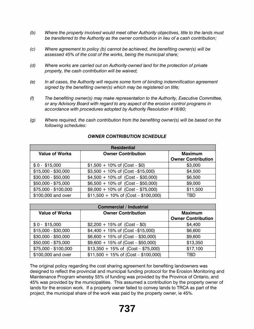
(g) Where required, the cash contribution from the benefiting owner(s) will be based on the following schedules:
OWNER CONTRIBUTION SCHEDULE
ResidentialValue of Works Owner Contribution Maximum
Owner Contribution$ 0 - $15,000 $1,500 + 10% of (Cost – $0) $3,000$15,000 - $30,000 $3,500 + 10% of (Cost –$15,000) $4,500$30,000 - $50,000 $4,500 + 10% of (Cost – $30,000) $6,500$50,000 - $75,000 $6,500 + 10% of (Cost – $50,000) $9,000$75,000 - $100,000 $9,000 + 10% of (Cost – $75,000) $11,500$100,000 and over $11,500 + 10% of (Cost – $100,000) TBD
Commercial / IndustrialValue of Works Owner Contribution Maximum
Owner Contribution$ 0 - $15,000 $2,200 + 15% of (Cost – $0) $4,400$15,000 - $30,000 $4,400 + 15% of (Cost –$15,000) $6,600$30,000 - $50,000 $6,600 + 15% of (Cost – $30,000) $9,600$50,000 - $75,000 $9,600 + 15% of (Cost – $50,000) $13,350$75,000 - $100,000 $13,350 + 15% of (Cost – $75,000) $17,100$100,000 and over $11,500 + 15% of (Cost – $100,000) TBD
The original policy regarding the cost sharing agreement for benefiting landowners was designed to reflect the provincial and municipal funding protocol for the Erosion Monitoring and Maintenance Program whereby 55% of funding was provided by the Province of Ontario, and 45% was provided by the municipalities. This assumed a contribution by the property owner of lands for the erosion work. If a property owner failed to convey lands to TRCA as part of the project, the municipal share of the work was paid by the property owner, ie 45%.
738
Through changes in the provincial mandate and downloading of financial responsibilities to the municipalities over the years, the amount of funding provided directly by the Province has been severely diminished, leaving municipalities to effectively provide 100% of the cost. The policy regarding the cost-sharing formula for benefiting landowners needs to be revised to reflect the fact that the current contributions of municipalities to erosion control projects is 100%.
Therefore, it is recommended that the wording of clause (c) of the policy as set out above be revised such that when a property owner does not convey lands to TRCA, their share of the project will be 100%.
Program ConstraintsThe Erosion Control Monitoring and Maintenance Program is significantly limited in its ability to perform as per the original mandate to undertake major maintenance works on existing erosion control works, to construct new erosion control works, or to provide assistance in high risk erosion sites in a timely manner due to a lack of contingency funding available.
Funding for the program has remained static, while the number of erosion control structures reaching life-expectancy (approximately 25 years) is increasing annually. Staff anticipates that approximately $11,000,000 would be required within the next few years to complete major maintenance on, or replacement of, the aging erosion control infrastructure within TRCA's jurisdiction. This does not include the additional new sites and structures added to the inventory annually. Cost, and risk to life and property, increase with every year that work is delayed.
Based on a recent assessment of future program requirements, it was determined that of the approximately 19,500 metres of erosion protection structures within the valley systems, 6,500 metres require either major maintenance or replacement at an anticipated cost of $6,000,000. Similarly, for the Lake Ontario waterfront within TRCA's jurisdiction, approximately $5,000,000 worth of major maintenance to over 18,000 metres of existing shoreline protection is required.
It is noted that there has been an overall reduction in the number of new developments at risk of erosion as the result of the adoption of the Valley and Stream Corridor Program and updates to Ontario Regulation 166/06 (formerly Ontario Regulation 158) of the Conservation Authorities Act. However, the program is not designed to react in a timely manner to the identification of new extreme erosion hazard sites.
In 2009, a record number of landslides have been reported in the City of Toronto including sites previously not monitored by TRCA as part of the program. Sites of significant risk include; Troutbrooke Drive (Ward 9), Beaucourt Road (Ward 5) and Denison Road West (Ward 11). These sites have incurred significant erosion damage and are at high risk for further loss of land, but have not previously been identified as projects for funding.
739
For 2009, the total program budget is approximately $600,000. Ten (10) major and fifteen (15) minor projects and studies are scheduled to be completed during this year through the program to address erosion and bank instability issues within TRCA's jurisdiction. These projects and studies account for roughly 3% of the over 800 sites and structures actively being monitored by TRCA. Due to the financial constraints on this program, TRCA typically must prioritize work based on risk and phase larger projects over several years, which increases costs and disruption to the affected community. Additionally, due to the budgetary limitation, funding for large-scale projects is often requested as a separate line item in TRCA capital budgets.
CONCLUSIONThe Erosion Control Monitoring and Maintenance Program is an integral part of TRCA’s connection with the municipalities within the jurisdiction. This program allows TRCA to be involved in providing first response aid to urgent situations, which ensures the ongoing integrity of watersheds, and the protection of watersheds and people who reside within.
By revising the existing cost-sharing agreement for benefiting landowners to reflect the current level of funding by the municipalities, this will allow for a clear understanding of the financial obligations of all parties involved in the program.
FINANCIAL DETAILSThe Erosion Control Monitoring and Maintenance Program is funded by the City of Toronto and the regional municipalities of Durham, Peel and York Region. Limited funding is provided by the Province of Ontario on a priority basis from the province-wide ranking of flood and erosion control structures. Additional funding is generated through partnership projects with various municipalities.
Report prepared by: Patricia Newland, 416-392-9690Email: [email protected] Information contact: Patricia Newland, 416-392-9690Email: [email protected]: August 28, 2009
_________________________________________
RES.#B118/09 - EAST DON TRAIL (CHARLES SAURIOL RESERVE) PHASE 1Award of Contract RSD09-24 - Pedestrian Footbridge. Award of contract for the supply and installation of a pedestrian footbridge over the East Don River as part of the East Don Trail - Phase 1 implementation at the Charles Sauriol Reserve.
Moved by: Maja PrenticeSeconded by: Colleen Jordan
740
THE EXECUTIVE COMMITTEE RECOMMENDS THAT the contract for the supply and installation of a pedestrian bridge over the East Don River be awarded to Hobden Construction Company Limited at a cost not to exceed $207,509.94, plus applicable taxes, it being the lowest tender meeting Toronto and Region Conservation Authority (TRCA) specifications;
AND FURTHER THAT authorized staff be directed to take the action necessary to implement the contract including obtaining any approvals and the signing and execution of documents.
CARRIEDBACKGROUNDIn 1995, R.V. Anderson and Associates (RVA) was retained by the City of Toronto to undertake a comprehensive study and provide proposed trail networking options in the East Don Valley system spanning from Milne Hollow (Lawrence Avenue/Don Valley Parkway) to the forks of the Don River. The study was completed in 1997 and resulted in a conceptualized alignment and network of trails servicing the East Don valleylands.
As part of the 2008 sole source projects with the City of Toronto, the city requested that TRCA implement trail planning and design for Phase 1a works in the Milne Hollow/East Don project area including:
preparation of trail network engineering design and construction details; anddesign for a wetland outlet control structure.
In June, 2008, TRCA engaged the services of RVA to complete the Phase 1a trail network engineering design component. This was undertaken in anticipation of construction commencing either later in 2008 or 2009.
The East Don Trail - Phase 1a construction includes a 34 metre prefabricated, self-weathering steel pedestrian footbridge. The construction was given approval to proceed by Resolution #A44/09 at Authority Meeting #3/09, held on April 24, 2009, subject to funding from the City of Toronto as part of the 2009/2010 Natural Environment and Stand Alone sole source projects and completion of the required approval processes.
RATIONALERequest for Quotations (RFQ) were sent to the following eight (8) contractors/suppliers, who were selected based on their area of business expertise and past experience on TRCA projects:
The RFQ packages requested bids for the following work:installation of helical pier footings and associated work;supply of a self-weathering steel pedestrian bridge; anddelivery and installation.
741
Sealed quotations were received on August 26, 2009 and were opened in accordance with TRCA's procurement and tendering practices. The bid results are as follows:
Company Bid(Plus GST)
Eagle Bridge Inc no direct bid - subcontractor to other
biddersDynex Construction $302,170.00Hobden Construction Co Ltd $207,509.94McPherson-Andrews Contracting $262,054.54
Staff reviewed the three bids received and is satisfied that the bid submitted by Hobden Construction Co Ltd., being the lowest received and meeting all specifications and criteria, represents fair value for this contract. The contractor is prepared to commence work as soon as approval is granted.
FINANCIAL DETAILSAll expenditures that pertain to this contract will be assigned to the East Don Trail Network project budget account 117-49. These expenses are fully recoverable from the City of Toronto.
Report prepared by: Dave Rogalsky, extension 5378Email: [email protected] Information contact: Dave Rogalsky, extension 5378Email: [email protected]: August 26, 2009
_________________________________________
SECTION II - ITEMS FOR EXECUTIVE ACTION
RES.#B119/09 - ASBESTOS POLICYApproval of the Asbestos Policy for the management of asbestos in Toronto and Region Conservation Authority buildings and facilities.
Moved by: Ron MoeserSeconded by: Colleen Jordan
THAT Toronto and Region Conservation Authority's (TRCA) Asbestos Policy for managing asbestos within TRCA buildings and facilities as outlined in the staff report be approved;
AND FURTHER THAT the Asbestos Management Plan (AMP) be reviewed by staff on a regular basis to ensure that it is in compliance with Ontario Regulation 278/05 and be updated as required.
CARRIED
742
BACKGROUNDAsbestos is a naturally occurring fibrous mineral with excellent insulating and fire-resistant properties that was used extensively in building construction. Asbestos Containing Materials (ACM) occur in numerous forms such as adhesives, blown-in (loose fill) insulation, caulking/putties, ceiling tiles, cement pipes, vinyl floor tiles, electric wiring insulation, fireproofing material, HVAC duct insulation, roofing shingles, textured paints and wallboard. Materials containing asbestos are classified as either friable or non-friable. A friable material, such as thermal insulation, is defined as an ACM that when dry can be easily crumbled to powder by hand. Non-friable materials, such as tiles or plasters, cannot be crumbled easily by hand pressure.
The use of asbestos in building materials discontinued in the 1980’s, however asbestos containing materials are still present in numerous buildings constructed prior to this date. The use of ACM is still practiced today, but application is controlled by restrictions and regulations. Since some applications of ACM are still common today, newer construction properties can also be subject to asbestos containing materials.
Medical research recognized health concerns related to asbestos and consequently it has been a regulated substance in Ontario since 1986. There has been a banning of the use of asbestos in most products, strict requirements for the handling and disposal of any asbestos containing material and specific industrial hygiene practices relating to asbestos containing products. These actions are reflected in Ontario Regulation 278/05 which covers the use and treatment of asbestos in buildings, made under the Occupational Health and Safety Act, effective June 8, 2005.
Since a large percentage of TRCA buildings were constructed before the discontinuation of asbestos containing materials, staff conducted a general review of available original architectural diagrams and tender packages. This review resulted in the confirmation of ACM present at some TRCA facilities. It is suspected that other TRCA buildings built prior to the 1980's, may also contain asbestos containing material. The ongoing commitment of TRCA to create a safe and healthy workplace and adhere to Ontario Regulation 278/05 is reflected in the Asbestos Policy.
RATIONALETo comply with Ontario Regulation 278/05 and strengthen protections for employees and visitors, TRCA staff has developed the Asbestos Policy outlined in this staff report, and the associated management plan. It is the objective of TRCA to provide a healthy and safe environment for its staff and for all persons utilizing TRCA property. The main purpose of this policy is to outline the identification, classification, documentation, handling and notification processes for all asbestos containing materials on TRCA properties to ensure a safe environment is provided.
The Asbestos Policy is a management tool used to assist in the control of any activities that may disturb ACM at facilities that are owned or managed by TRCA. The Asbestos Policy is as follows:
Asbestos building material surveys (asbestos survey) will be performed to identify, locate and evaluate materials.Where it is identified, ACM will be inspected at least annually to examine its condition.
743
Employees of TRCA and any contractors who enter a facility and may disturb ACM will be notified of its presence, and appropriate notification and/or training will be provided, prior to performing work.Removal or repair of all friable ACM identified in the asbestos surveys will be completed as soon as possible. Only qualified asbestos removal contractors will perform Type 1, Type 2 and Type 3 removal work.Any ACM that may be disturbed during maintenance, renovation or demolition activities at the facilities will be removed prior to these activities. Qualified asbestos removal contractors will perform all Type 1, Type 2 and Type 3 removal work.ACM removal or repairs will be monitored to ensure compliance with O. Reg. 278/05.Emergency response and notification procedures in the event of an ACM release have been established.All asbestos records will be maintained and are available at any time.Training for TRCA employees will be provided.
The Asbestos Management Plan (to be made available upon request) is the procedural guidelines developed for staff to administer the policy.
FINANCIAL DETAILSTRCA staff is conducting an inventory of facilities to determine the cost of implementing the policy.
Report prepared by: Brad Clubine, extension 5252Emails: [email protected] Information contact: Brad Clubine, extension 5252Emails: [email protected]: August 28, 2009
_________________________________________
RES.#B120/09 - RELIGIOUS OFFERINGS AND SCATTERING OF ASHESStaff update on outreach activities to the Hindu community with respect to religious offerings and recent provincial statement on scattering of ashes.
Moved by: Maja PrenticeSeconded by: Colleen Jordan
THAT Item EX7.1 - Religious Offerings and Scattering of Ashes, be referred back to staff for a more detailed report including results of discussions with the Province of Ontario and other relevant agencies.
CARRIED _________________________________________
744
SECTION IV - ITEMS FOR THE INFORMATION OF THE BOARD
RES.#B121/09 - DISPOSAL OF TORONTO AND REGION CONSERVATION AUTHORITY LANDApplication of Conditions. Summary of options for protecting, complying with and satisfying Toronto and Region Conservation Authority (TRCA) interests and concerns on dispositions of TRCA-owned land to ensure that such land is not used in any manner TRCA considers inappropriate.
Moved by: Ron MoeserSeconded by: Maja Prentice
THAT the staff report dated August 26, 2009 in regard to options to ensure land sold by TRCA is used in a manner that TRCA considers appropriate, be received.
CARRIEDBACKGROUNDAt Executive Committee Meeting #5/09, held on July 10, 2009, Resolution #B103/09 was approved as follows:
THAT staff be directed to report back at Executive Committee Meeting #6/09, to be held on August 7, 2009, on how Toronto and Region Conservation Authority (TRCA) can include a mechanism/covenant to ensure lands sold by TRCA can not be used in any manner that the TRCA considers inappropriate.
Staff delayed this report until this meeting because the August Executive Meeting was a conference call meeting.
RATIONALECurrent Review Process When a request is received to dispose of a parcel of TRCA land, it is circulated to TRCA technical staff for review and comment. If it is determined through this review process that there is a parcel of land that might be sold, it is also reviewed to determine any potential impacts on adjacent TRCA lands. Based on this second part of the review, if potential impacts exist, restrictions are determined to mitigate these potential impacts. These restrictions would be identified in the recommendation to the Executive Committee when the property is being declared surplus, and in the report recommending the sale of the property. If it is determined that a parcel of TRCA land is available for disposal, the local and regional municipalities within which the parcel is located will be circulated to determine if they have any interest in the parcel. If there is no municipal interest, the parcel will be offered for disposal at market value. All disposals must be approved by the Authority.
745
Sales to Private Owners In the past TRCA has used a number of mechanisms/covenants to ensure lands, or interests or easements in or on the lands, sold by TRCA cannot be used in any manner that the TRCA considers inappropriate. These mechanisms may include restricting certain uses on the lands to be sold or give TRCA the right to comment on and/or approve the development on the lands sold by TRCA. The mechanisms used by TRCA have included restrictive covenants registered on title, options to purchase agreements and terms and conditions in the agreements of purchase and sale or undertakings that are to continue after the sale is completed. TRCA can use "conservation easements" pursuant to the Conservation Land Act. Generally, the more restrictive the mechanism, the greater the potential impact on the market value. The following is a brief discussion of each of these mechanisms:
Restrictive Covenants on TitleThis is the most common method used by TRCA in sales to private owners/developers. These sales are typically tableland portions of larger TRCA holdings. The restrictive covenants are placed on the lands being sold to protect the retained land as much as possible from the impacts of the uses contemplated for the lands being sold. The following are a few examples of restrictions used in the past. In the sale of the northeast corner of Jane Street and Steeles Avenue, City of Vaughan, TRCA: restricted the building height to six stories; did not allow gas station or obnoxious, industrial or commercial uses; the development concept and details were to be compatible with Black Creek Pioneer Village and TRCA had the right to approve the development; requires a mitigation plan for vegetation preservation; and the purchaser must control stormwater quality and quantity. In the sale at the southeast corner of Islington Avenue and Rutherford Road, City of Vaughan, TRCA: restricted the use to single family residential; no stormwater was permitted to enter TRCA's retained lands unless a stormwater management program was implemented to TRCA's satisfaction and purchaser had to use stormwater best management practices. In the sale of a number of residential lots in the Fairport Beach area of the City of Pickering, TRCA: restricted the use to single family residential; and the owners agreed not to oppose the construction of a waterfront park on adjacent TRCA lands.
Option to Purchase AgreementThis gives TRCA the right to buy back the property should the purchaser wish to re-sell and insures TRCA will receive a share of the profit on a resale where a purchaser having bought the property from TRCA, thereafter resells the property for a large profit. These agreements would remain in place for a specific period of time such as 10 or 15 years and may include further refinements to provide for profit sharing on a possible resale.
Conditions in the Agreement of Purchase and Sale/UndertakingsThis method has been used to deal with items such as providing fencing of the boundary and the establishment of vegetated buffer areas on TRCA adjacent lands whereby security is obtained (usually a letter of credit) to ensure the work is completed within stipulated periods of time.
Easements and StrataIn some instances TRCA , rather than conveying property, simply gives an easement over land that permits limited and specified uses. Typically this is used with other public bodies. Also while the use is not common, TRCA may sell a strata of land below the surface and TRCA maintains surface ownership. This is what has been employed in the Motel Strip where a 28.5 metre strata commencing 1.5 metres below the surface is being sold.
746
Conservation Easements – Under the Conservation Land ActGenerally these are most restrictive and only allow conservation and greenspace uses on the property. A conservation easement will have a major impact on land with development potential. To date, TRCA has not had a need to use conservation easements when selling property since this level of protection is generally reserved for properties that contain significant ecological features. TRCA has retained ownership of these type of properties to provide the highest level of protection.
Sales to Public BodiesThis is the conveyance of land to local and regional municipalities and the provincial government for infrastructure projects. Through a review of the project, TRCA staff is able to ensure measures are implemented that mitigate the impact of the project on retained TRCA property. Staff has not found it necessary to impose restrictive covenants in these sales as our municipal and provincial partners have been cooperative in implementing measures to mitigate the impacts of their projects on TRCA lands.
TRCA staff, when considering possible dispositions recognize that restricting uses on lands being sold will impact the price and will attempt to achieve a balance between providing the best possible protection to the adjacent TRCA lands while minimizing the impact on market value.
DETAILS OF WORK TO BE DONEStaff will continue to apply the foregoing policy with respect to disposal of TRCA lands. Each disposal must be approved by the Authority and staff will continue to carefully highlight conditions of each disposal so that the members are aware of special circumstances.
Report prepared by: Mike Fenning, extension 5223Emails: [email protected] Information contact: Mike Fenning, extension 5223 or Ron Dewell, extension 5245Emails: [email protected] or [email protected]: August 26, 2009
_________________________________________
RES.#B122/09 - CONSERVATION LAND TAX INCENTIVE PROGRAMUpdate on the realty tax exemptions under the Conservation Land Tax Incentive Program.
Moved by: Colleen JordanSeconded by: Ron Moeser
THAT the staff report dated August 25, 2009 in regard to the update on the realty tax exemptions under the Conservation Land Tax Incentive Program be received.
CARRIED _________________________________________
747
ONTARIO REGULATION 166/06
RES.#B123/09 - APPLICATIONS FOR PERMITS PURSUANT TO ONTARIO REGULATION 166/06Development, Interference with Wetlands and Alterations to Shorelines and Watercourses. Pursuant to Ontario Regulation 166/06, written permission from the Authority is required for:
a) straightening, changing, diverting or interfering in any way with the existing channel of a river, creek, stream or watercourse, or for changing or interfering in any way with a wetland;
b) development, if in the opinion of the authority, the control of flooding, erosion, dynamic beaches or pollution or the conservation of land may be affected by the development.
A permit may be refused through a Hearing Process, if in the opinion of the Authority, the control of flooding, erosion, dynamic beaches, pollution or the conservation of land is affected.
Moved by: Richard WhiteheadSeconded by: Ron Moeser
THAT permits be granted in accordance with Ontario Regulation 166/06 for the applications (EX10.1 - EX10.41 and EX10.105 - EX10.110, with the exception of EX10.6, EX10.13 and EX10.21) which are listed below.
CARRIED
RES.#B124/09 - APPLICATIONS FOR PERMITS PURSUANT TO ONTARIO REGULATION 166/06
Moved by: Jack HeathSeconded by: Maja Prentice
THAT a permit be granted in accordance with Ontario Regulation 166/06 for the application EX10.6 - City of Toronto, which is listed below.
CARRIED
RES.#B125/09 - APPLICATIONS FOR PERMITS PURSUANT TO ONTARIO REGULATION 166/06
Moved by: Maria AugimeriSeconded by: David Barrow
THAT a permit be granted in accordance with Ontario Regulation 166/06 for the application EX10.13 - City of Toronto, which is listed below.
CARRIED
RES.#B126/09 - APPLICATIONS FOR PERMITS PURSUANT TO ONTARIO REGULATION 166/06
748
Moved by: Jack HeathSeconded by: Maja Prentice
THAT a permit be granted in accordance with Ontario Regulation 166/06 for the application EX10.21 - City of Toronto, which is listed below.
CARRIED
CITY OF BRAMPTON
EX10.1 CITY OF BRAMPTONTo construct, reconstruct, erect or place a building or structure, site grade and temporarily or permanently place, dump or remove any material, originating on the site or elsewhere on , (Kiwanis Memorial Park), in the City of Brampton, Etobicoke Creek Watershed as located on the property owned by City of Brampton and Toronto and Region Conservation Authority.
The purpose is to install a prefabricated pedestrian bridge over the Etobicoke Creek, remove the existing concrete walkway, re-align the existing asphalt pathway, rehabilitate the creek bed, remove the existing gabion baskets and concrete apron, and naturalize the banks. The works will be conducted during the warmwater fisheries timing window of July 1 - March 31 and a Letter of Advice will be written by TRCA staff on behalf of Fisheries and Oceans Canada (DFO) for this project.
The permit will be issued for the period of September 11, 2009 to September 10, 2011 in accordance with the following documents and plans which form part of this permit:
Sheet 2 - Etobicoke Creek Bank Restoration - Hurontario Rd. to Proposed Bridge Crossing General plan; dated July 2009; received July 21, 2009; prepared by Planmac Inc; on behalf of the City of Brampton;Sheet 3 - Etobicoke Creek Bank Restoration - Hurontario Rd. to Proposed Bridge Crossing Cross Sections; dated July 2009; received July 21, 2009; prepared by Planmac Inc; Sheet 4; - Etobicoke Creek Bank Restoration - Hurontario Rd. to Proposed Bridge Crossing Cross Sections; dated July 2009; received July 21, 2009; prepared by Planmac Inc; Sheet 5 - Etobicoke Creek Bank Restoration - Hurontario Rd. to Proposed Bridge Crossing Details; dated July 2009; received July 21, 2009; prepared by Planmac Inc; Sheet 1 of 5 - Site Plan; dated May 30, 2008; received July 21, 2009; prepared by Planmac Inc;Sheet 2 of 5 - General Arrangement and Cross Sections; dated May 30, 2008; received July 21, 2009; prepared by Planmac Inc;Sheet 3 of 5 - Removals Stages 1 and 2; dated May 30, 2008; received July 21, 2009; prepared by Planmac Inc.
RATIONALEThe application was reviewed by staff on the basis of the following information:
749
Proposal:The proposed works will take place in Kiwanis Memorial Park located on the east side of Hurontario Street, south of Peel Village Parkway in the City of Brampton. The proposal consists of installing a prefabricated pedestrian bridge downstream of the existing concrete walkway, re-aligning the asphalt pedestrian pathway to the new pedestrian bridge, removing the existing concrete walkway, gabion baskets, and the concrete apron upstream of the new pedestrian bridge, placing gravel and cobblestone at the location of the previous concrete walkway to restore the stream bed, providing restoration plantings and naturalizing the stream banks upstream of the new pedestrian bridge.
Control of Flooding:There will be no impact to the control of flooding.
Pollution:Standard sediment and erosion controls (silt fence, cofferdams, filterbag or splash pad) will be in place for the duration of construction, and until the site is restored.
Dynamic Beaches:Not applicable
Erosion:There are no geotechnical/slope stability issues associated with the proposal.
Conservation of Land:With the erosion and sediment controls in effect, the potential for a Harmful Alteration, Disruption or Destruction (HADD) of fish habitat will be mitigated and a Letter of Advice (LOA) will be written by TRCA staff on behalf of Fisheries and Oceans Canada (DFO). The banks upstream of the new pedestrian bridge will be naturalized. All construction activity will only be carried out during the warmwater timing window of July 1 to March 31.
PlantingsAll disturbed areas will be restored with native seedmix and native plantings following construction. A net ecological gain will be achieved for this site.
Policy Guidelines:This proposal complies with Section 4.1.2, New Resource-based Uses and Section 4.3, Infrastructure and Servicing, of the TRCA's Valley and Stream Corridor Management Program.
CFN: 40976 - Application #: 450/08/BRAMReport Prepared by: Ben Krul, extension 5769For information contact: Sharon Lingertat, extension 5717Date: September 1, 2009
CITY OF PICKERING
EX10.2 1760 FINCH AVENUETo construct, reconstruct, erect or place a building or structure on Part Lot 18, Concession 25 Part Lot 2, Plan RP40 R8590, (1760 Finch Avenue), in the City of Pickering, Duffins Creek Watershed.
750
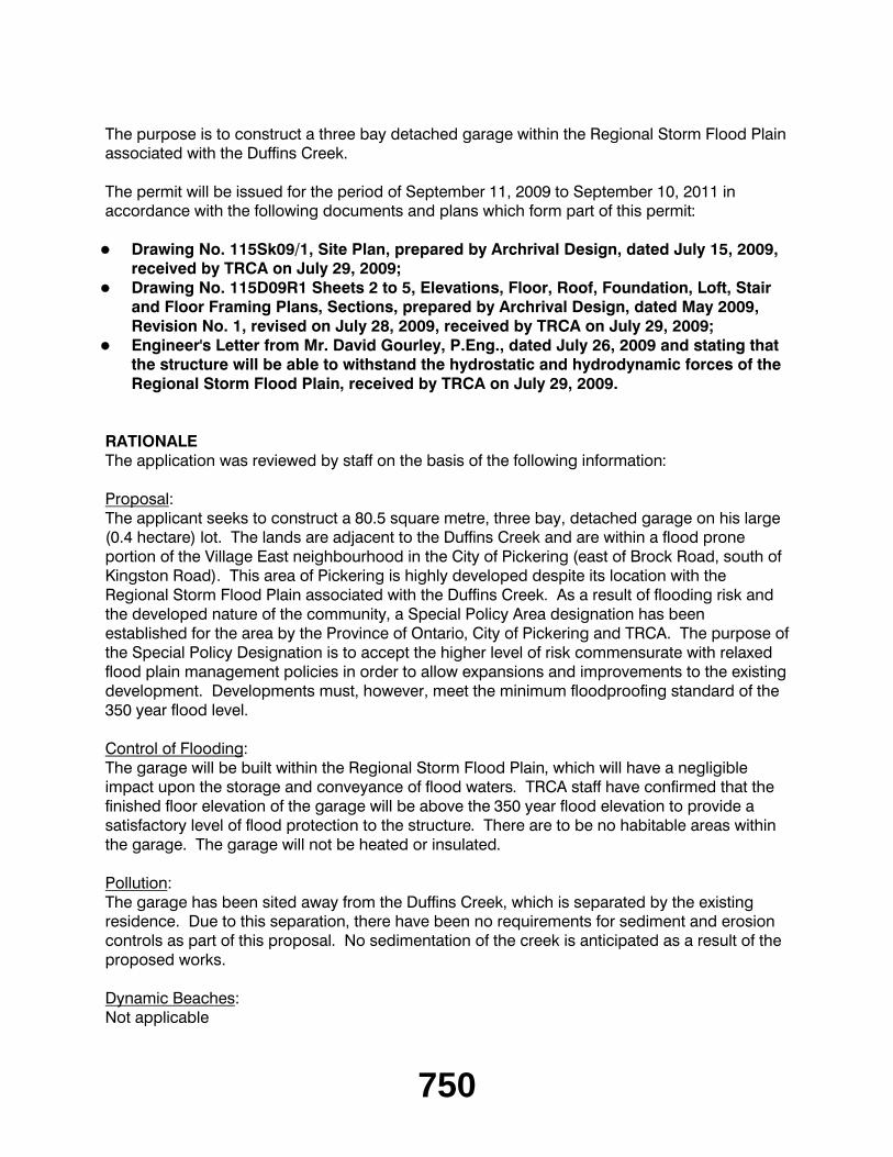
The purpose is to construct a three bay detached garage within the Regional Storm Flood Plain associated with the Duffins Creek.
The permit will be issued for the period of September 11, 2009 to September 10, 2011 in accordance with the following documents and plans which form part of this permit:
Drawing No. 115Sk09/1, Site Plan, prepared by Archrival Design, dated July 15, 2009, received by TRCA on July 29, 2009;Drawing No. 115D09R1 Sheets 2 to 5, Elevations, Floor, Roof, Foundation, Loft, Stair and Floor Framing Plans, Sections, prepared by Archrival Design, dated May 2009, Revision No. 1, revised on July 28, 2009, received by TRCA on July 29, 2009;Engineer's Letter from Mr. David Gourley, P.Eng., dated July 26, 2009 and stating that the structure will be able to withstand the hydrostatic and hydrodynamic forces of the Regional Storm Flood Plain, received by TRCA on July 29, 2009.
RATIONALEThe application was reviewed by staff on the basis of the following information:
Proposal:The applicant seeks to construct a 80.5 square metre, three bay, detached garage on his large (0.4 hectare) lot. The lands are adjacent to the Duffins Creek and are within a flood prone portion of the Village East neighbourhood in the City of Pickering (east of Brock Road, south of Kingston Road). This area of Pickering is highly developed despite its location with the Regional Storm Flood Plain associated with the Duffins Creek. As a result of flooding risk and the developed nature of the community, a Special Policy Area designation has been established for the area by the Province of Ontario, City of Pickering and TRCA. The purpose of the Special Policy Designation is to accept the higher level of risk commensurate with relaxed flood plain management policies in order to allow expansions and improvements to the existing development. Developments must, however, meet the minimum floodproofing standard of the 350 year flood level.
Control of Flooding:The garage will be built within the Regional Storm Flood Plain, which will have a negligible impact upon the storage and conveyance of flood waters. TRCA staff have confirmed that the finished floor elevation of the garage will be above the 350 year flood elevation to provide a satisfactory level of flood protection to the structure. There are to be no habitable areas within the garage. The garage will not be heated or insulated.
Pollution:The garage has been sited away from the Duffins Creek, which is separated by the existing residence. Due to this separation, there have been no requirements for sediment and erosion controls as part of this proposal. No sedimentation of the creek is anticipated as a result of the proposed works.
Dynamic Beaches:Not applicable
751
Erosion:There are no slope stability or geotechnical concerns with the project.
Conservation of Land:The garage has been sited within an area that is currently a manicured lawn. No natural heritage features are to be disturbed as part of this proposal.
PlantingsAs no vegetation is to be removed for the garage construction, no plantings were required by TRCA staff.
Policy Guidelines:This proposal is consistent with Section 4.2.1 B, Development Guidelines for Development/Redevelopment within Designated Two Zone Areas or Special Policy Areas, of TRCA's Valley and Stream Corridor Management Program.
CFN: 42607 - Application #: 0461/09/PICKReport Prepared by: Chris Jones, extension 5718For information contact: Chris Jones, extension 5718Date: September 1, 2009
CITY OF TORONTO (ETOBICOKE YORK COMMUNITY COUNCIL AREA)
EX10.3 AMEXON HOLDINGS INCTo construct, reconstruct, erect or place a building or structure, site grade and temporarily or permanently place, dump or remove any material, originating on the site or elsewhere on Lot 7, 18, Plan 83, (60 - 88 Park Lawn Road), in the City of Toronto (Etobicoke York Community Council Area), Mimico Creek Watershed as located on the property owned by Amexon Holdings Inc.
The purpose is to regrade, install stormwater infrastructure including sewers, erosion control and an outfall to Mimico Creek, install a temporary retaining wall, and restore the site with temporary seeding in order to facilitate the development of a multi-storey residential condominium building and underground parking.
The permit will be issued for the period of September 11, 2009 to September 10, 2011 in accordance with the following documents and plans which form part of this permit:
Drawing No. A-101, Site Plan, by Arsenault Architect, Revision 1, revised June 9, 2009, received August 31, 2009;Drawing No. SG1, Site Servicing and Grading Plan, by MMM, Revision 5, revised August 26, 2009, received August 31, 2009;Drawing No. ER1, Erosion and Sediment Control Plan with Existing, by MMM, Revision 5, revised August 26, 2009, received August 31, 2009;Drawing No. ER1A, Erosion and Sediment Control Plan with Proposed, by MMM, Revision 5, revised August 26, 2009, received August 31, 2009;Drawing No. ER2, Erosion and Sediment Control Notes and Details, by MMM, Revision 5, revised August 26, 2009, received August 31, 2009;
752
Drawing No. P1, Outlet to Mimico Creek, by MMM, Revision 4, revised August 26, 2009, received August 31, 2009;Drawing No. NT1, Notes, by MMM, Revision 5, revised August 26, 2009, received August 31, 2009;Drawing No. L1, Landscape Plan, Ground Level, prepared by Cosburn Associates, Revision 10, revised August 26, 2009, received August 31, 2009;Drawing No. L2, Grading Plan, prepared by Cosburn Associates, Revision 10, revised August 26, 2009, received August 31, 2009;Drawing No. L3, Sections, prepared by Cosburn Associates, Revision 10, revised August 26, 2009, received August 31, 2009;Drawing No. L4, Planting Plan, Ground Level, prepared by Cosburn Associates, Revision 10, revised August 26, 2009, received August 31, 2009;Drawing No. L6, Mimico Creek Bank Stabilization Plan, prepared by Cosburn Associates, Revision 10, revised August 26, 2009, received August 31, 2009.
RATIONALEThe application was reviewed by staff on the basis of the following information:
Proposal:The proposal is to regrade, install stormwater infrastructure including sewers, erosion control and an outfall to Mimico Creek, install a temporary retaining wall, and restore the site with temporary seeding in order to facilitate the construction of a multi-storey residential condominium building and underground parking. The site is referred to as the South Beach Condominiums and is located on the west side of Parklawn Road, south of the Queen Elizabeth Way and north of Lake Shore Boulevard West. The western portion of the property is within the Mimico Creek valley and is currently developed up to the top of bank with deteriorated retaining structures and paved parking. The project has been subject to extensive review through the City of Toronto Official Plan and Zoning By-law Amendment process, and the subsequent Site Plan review process.
The redevelopment of the site will provide for: 1) removal of asphalt and deteriorated retaining walls in the valley; 2) the regrading of the slope to a more natural stable gradient; 3) restoration of the appropriate 10 metre buffer from the stable top of bank to accommodate a portion of the future proposed Mimico Creek trail link; and 4) water quality and quantity controls. The temporary retaining wall is required to retain the final grades up against the adjacent private property to the south which is not at this time subject to a development proposal. TRCA staff are currently working with the City of Toronto to complete the design of the lower portions of the Mimico Creek Trail. The trail link through the site can only be built upon completion of the design and the redevelopment of the remaining sites along the west side of Parklawn Road. Once the trail is ready for implementation, the temporary retaining wall can be removed and regrading of the South Beach site and the private property to the south can take place along with the installation of the trail and final plantings. A letter of credit for these works has been given to the City of Toronto to guarantee the works will take place in the future.
753
Conditional Permit:Modifications to Mimico Creek using natural channel design is required in order to provide for the appropriate erosion control, renaturalized buffers, future trail works, and ultimately facilitate the redevelopment of the site. However, as the creek modifications are primarily located on adjacent CN Rail and City of Toronto lands, these works will be the subject of a future TRCA permit application upon final approval by the landowners. The detailed design of the natural channel works has been reviewed by TRCA staff and a letter of credit for these works will be given to the City of Toronto to guarantee the works will take place. The issuance of this permit is conditional upon receipt of the letter of credit.
Control of Flooding:The only portion of the works located within the Regional Storm Floodplain is the proposed stormwater outfall. The outfall will have no impact on the storage or conveyance of flood waters.
Pollution:Temporary sediment control has been provided per the Greater Golden Horseshoe Area Conservation Authorities, Erosion and Sediment Control Guideline for Urban Construction.
Dynamic Beaches:Not applicable.
Erosion:Temporary erosion control has been provided per the Greater Golden Horseshoe Area Conservation Authorities, Erosion and Sediment Control Guideline for Urban Construction. The existing slope will be regraded to a more natural stable gradient and therefore there are no geotechnical issues with the proposal.
Conservation of Land:The proposal will result in a return of a portion of the valley to a more natural state. The proposed building and underground parking are set back in excess of 10 metres from the stable top of bank. Vegetation removals are limited to non-native species.
PlantingsUntil the design of the trail is completed and a final landscaping plan can be implemented, the restoration plantings will be limited to a native seed mix to stabilize the restored slope. The final landscaping plan approved as part of the Site Plan can be implemented in the future when conditions allow for the trail to be installed and the temporary retaining wall removed. The approved plan includes native seed mix, shrubs and trees.
Policy Guidelines:The proposal is consistent with Section 4.2.2., Development within Non-Established/Highly Urbanized Areas, of the TRCA's Valley and Stream Corridor Management Program.
CFN: 42602 - Application #: 0454/09/TORReport Prepared by: Steve Heuchert, extension 5311For information contact: Steve Heuchert, extension 5311Date: September 1, 2009
754
EX10.4 37 HALFORD AVENUETo change a building or structure so that it alters its use or potential use, increases its size or increases the number of dwelling units on Lot 64, Plan 950, (37 Halford Avenue), in the City of Toronto (Etobicoke York Community Council Area), Humber River Watershed.
The purpose is to construct a one and two storey rear addition to the existing single family detached dwelling at 37 Halford Avenue in the City of Toronto (Etobicoke York).
The permit will be issued for the period of September 11, 2009 to September 10, 2011 in accordance with the following documents and plans which form part of this permit:
Drawing No A-1, Site Plan, prepared by Patrick Cheeseman, dated June 15, 2009, Revision No. 1, revised on August 12, 2009, received on August 19, 2009;Drawing No A-8, Revised East Elevations, prepared by Patrick Cheeseman, dated June 15, 2009, Revision No. 1, revised on August 12, 2009, received on August 19, 2009;Drawing No A-9, West Elevation, prepared by Patrick Cheeseman, dated June 15, 2009, Revision No. 1, revised on August 12, 2009, received on August 19, 2009;Drawing No A-10, South Elevation, prepared by Patrick Cheeseman, dated June 15, 2009, Revision No. 1, revised on August 12, 2009, received on August 19, 2009;Drawing No A-11, North Elevation, prepared by Patrick Cheeseman, dated June 15, 2009, Revision No. 1, revised on August 12, 2009, received on August 19, 2009.
RATIONALEThe application was reviewed by staff on the basis of the following information:
Proposal:The purpose of this application is to construct a rear addition to the existing single family detached dwelling at 37 Halford Avenue in the City of Toronto (Etobicoke York). The subject site is located north of Bloor Street West and west of Jane Street within a Regulated Area of the Humber River Watershed. Due to the City of Toronto strike, this permit will be conditional upon the approval of Urban Forestry Services. Minor revisions to the approved plans required on behalf of Urban Forestry Services will be addressed by TRCA staff through redline revisions.
Control of Flooding:The site is not located within a regional storm flood plain and the proposal will have no impact on the storage and/or conveyance of floodwaters.
Pollution:Sediment controls are not required as the subject site is located at the toe of a slope and removed from the watercourse.
Dynamic Beaches:Not applicable.
Erosion:There are no slope stability/geotechnical concerns associated with this application.
755
Conservation of Land:The appropriate tree protection fencing will be installed.
PlantingsNative plantings will be provided as per City of Toronto Urban Forestry Ravine Protection Services Guidelines and recommendations pertaining to tree protection and maintenance during construction will be implemented.
Policy Guidelines:This proposal is consistent with Section 4.2.2.(B) - Development Guidelines for Minor Additions within Non-Established/Highly Urbanized Areas of the TRCA's Valley and Stream Corridor Management Program.
CFN: 42711 - Application #: 0533/09/TORReport Prepared by: Nicole Moxley, extension 5284For information contact: Steve Heuchert, extension 5311Date: September 1, 2009
EX10.5 2 GROVETREE ROADTo construct, reconstruct, erect or place a building or structure, site grade and temporarily or permanently place, dump or remove any material, originating on the site or elsewhere on 2 Grovetree Road, in the City of Toronto (Etobicoke York Community Council Area), Humber River Watershed.
The purpose is to acknowledge the construction of a replacement deck to the rear of the existing dwelling as well as allow for proposed hard and soft landscaping in the rear and side yards of the existing dwelling.
The permit will be issued for the period of September 11, 2009 to September 10, 2011 in accordance with the following documents and plans which form part of this permit:
Drawing unnumbered, Proposed Landscape Plan, prepared by Brian Lisi, undated, received on August 25, 2009;Drawing No. A2, Proposed Site Plan, prepared by Brian Lisi, undated, received on August 25, 2009.
RATIONALEThe application was reviewed by staff on the basis of the following information:
Proposal:The purpose of this application is to develop within a TRCA Regulated Area of the Humber River Watershed to acknowledge the construction of a replacement deck to the rear of the existing dwelling. The new rear deck is larger then the original deck which was in poor condition and required removal for safety reasons. This proposal also includes proposed hard and soft landscaping in the rear and side yards of the existing dwelling. The subject site is located west of Islington Avenue and south of Albion Road in the City of Toronto (Etobicoke York Community Council Area).
756
Permit After the Fact:The replacement deck to the rear of the existing dwelling was built without the benefit of any TRCA or municipal permits. As such, a penalty fee in the amount of 50% of the original permit fee has been received by TRCA staff.
Control of Flooding:The site is not located within a regional storm flood plain and the proposal will have no impact on the storage and/or conveyance of floodwaters.
Pollution:Sediment and erosion control fencing is not required as the proposed works are adequately set back from the watercourse.
Dynamic Beaches:Not applicable.
Erosion:There are no slope stability/geotechnical concerns associated with this application.
Conservation of Land:The proposed works are adequately set back from the top of bank. There are no other significant natural features on, or adjacent to, the site that would be negatively impacted by the project.
PlantingsNative plantings will be provided as per City of Toronto Urban Forestry Ravine Protection Services Guidelines and recommendations pertaining to tree protection and maintenance during construction will be implemented.
Policy Guidelines:This proposal is consistent with Section 4.2.2.(D) and (E) - Development Guidelines for Replacement Structures, Property Improvements and Ancillary Structures within Non-Established/Highly Urbanized Areas of the Authority's Valley and Stream Corridor Management Program.
CFN: 42887 - Application #: 0649/09/TORReport Prepared by: Nicole Moxley, extension 5284For information contact: Steve Heuchert, extension 5311Date: September 1, 2009
EX10.6 CITY OF TORONTOTo site grade and temporarily or permanently place, dump or remove any material, originating on the site or elsewhere on (Smithfield Park - Martin Grove and Albion), in the City of Toronto (Etobicoke York Community Council Area), Humber River Watershed as located on the property owned by City of Toronto.
757
The purpose is to replace the existing 1.5 metre granular trail with a 2 metre wide asphalt trail. A second 2 metre wide granular trail will be constructed along the existing footpath at the east limits of the park. TRCA staff will prepare a Letter of Advice on behalf of Fisheries and Oceans Canada (DFO) for the proposed work.
The permit will be issued for the period of September 11, 2009 to September 10, 2011 in accordance with the following documents and plans which form part of this permit:
Drawing No. L1; Landscape Plan; dated August 20, 2009; prepared by Cosburn Associates Limited on behalf of the City of Toronto - Parks; and received by TRCA on August 21, 2009
RATIONALEThe application was reviewed by staff on the basis of the following information:
Proposal:The proposed works consist of the replacement of an existing 1.5 metre granular trail with a 2 metre wide asphalt trail in Smithfield Park, Toronto. A second 2 metre wide granular/natural stone trail will be constructed to replace an existing footpath at the east limits of the park. The park currently comprises of sod, play equipment and seating features. No trees removals are proposed during construction. Prior to construction commencement, a tree protection and hoarding fence will be erected to protect the existing trees and restoration planting is proposed to compensate for the increased width of the pathway. The tree planting will be done between the proposed walkways and the top of bank. City of Toronto Urban forestry staff have been consulted regarding this project.
Control of Flooding:No impacts to flooding, flood storage or conveyance of flood waters are anticipated.
Pollution:Standard erosion and sediment control measures will be implemented prior to construction and maintained for the duration of construction, and until the site is stabilized and restored, in order to prevent the construction generated sediments from entering into the Humber River. Erosion and sediment control measures have been provided in accordance with the TRCA Erosion and Sediment Control Guideline for Urban Construction.
Dynamic Beaches:Not applicable
Erosion:There will be no geotechnical engineering or slope stability issues associated with the proposed works.
Conservation of Land:No vegetation removals are proposed. With erosion and sediment control measures in effect, the potential for a Harmful, Alteration, Disruption, and Destruction (HADD) of fish habitat will be mitigated. TRCA staff will prepare a Letter of Advice on behalf of DFO for the proposed work.
758
PlantingsAll disturbed areas will be restored with native, non-invasive species following construction. Additional 8 deciduous and coniferous trees will be planted as part of project.
Policy Guidelines:The proposal is consistent with Section 4.3. Infrastructure and Servicing, of the TRCA's Valley and Stream Corridor Management Program (VSCMP).
EX10.7 261 BERRY ROADTo change a building or structure so that it alters its use or potential use, increases its size or increases the number of dwelling units on Lot 6, 7, Plan 718, (261 Berry Road), in the City of Toronto (Etobicoke York Community Council Area), Mimico Creek Watershed.
The purpose is to construct a partial second storey addition to the existing single family detached dwelling at 261 Berry Road (Etobicoke York Community Council Area).
The permit will be issued for the period of September 11, 2009 to September 10, 2011 in accordance with the following documents and plans which form part of this permit:
Drawing No. A101, Site Plan, prepared by John Sibenik, dated March 9, 2009, Revision No. 4, revised on May 15, 2009, received on June 5, 2009;Drawing No. A301, North & West Elevations, prepared by John Sibenik, dated March 9, 2009, Revision No. 3, revised on May 15, 2009, received on June 5, 2009;Drawing No. A302, South & East Elevations, prepared by John Sibenik, dated March 9, 2009, Revision No. 3, revised on May 15, 2009, received on June 5, 2009;Drawing No. A401, Sections, prepared by John Sibenik, dated March 9, 2009, Revision No. 2, revised on May 15, 2009, received on June 5, 2009;Drawing No. L-1, Landscape Plan, prepared by Alexander Budrevics & Associates Limited, dated May 13, 2009, Revision No. 1, revised on May 14, 2009, received on June 5, 2009.
RATIONALEThe application was reviewed by staff on the basis of the following information:
Proposal:The purpose of this application is to construct a partial second-storey addition above the existing single family detached dwelling at 261 Berry Road in the City of Toronto (Etobicoke York Community Council Area). The existing footprint of the dwelling is to remain unchanged. The subject site is located north of The Queensway and east of Royal York Road within a TRCA Regulated Area of the Humber River Watershed.
759
Control of Flooding:The site is not located within a regional storm flood plain and the proposal will have no impact on the storage and/or conveyance of floodwaters.
Pollution:Sediment controls will be installed and maintained during construction to prevent debris from entering the watercourse.
Dynamic Beaches:Not applicable.
Erosion:Engineering letters (structural/civil and geotechnical) were provided to TRCA staff on August 31, 2009. The letters confirm that both the native soils and the existing dwelling's foundations are suitable to support the proposed partial second storey addition.
Conservation of Land:The proposed works are located no further than the existing limit of development. There are no other significant natural features on, or adjacent to, the site that would be negatively impacted by the project.
PlantingsNative plantings will be provided as per City of Toronto Urban Forestry Ravine Protection Services Guidelines and recommendations pertaining to tree protection and maintenance during construction will be implemented.
Policy Guidelines:This proposal is consistent with Section 4.2.2.(B) - Development Guidelines for Minor Additions within Non-Established/Highly Urbanized Areas of the TRCA's Valley and Stream Corridor Management Program.
CFN: 42176 - Application #: 0155/09/TORReport Prepared by: Nicole Moxley, extension 5284For information contact: Steve Heuchert, extension 5311Date: September 1, 2009
EX10.8 14 VALLEYMEDE ROADTo construct, reconstruct, erect or place a building or structure on Lot 1, Part Lots 2 AND 3, Plan M-579, Lot 21, Plan M-611, (14 Valleymede Road), in the City of Toronto (Etobicoke York Community Council Area), Humber River Watershed.
The purpose is to construct a replacement retaining wall along the rear yard (west) property boundary of the existing single family detached dwelling at 14 Valleymede Road and the side yard (east) property boundary of the existing single family detached dwelling at 3 Deforest Road in the City of Toronto (Etobicoke York). The existing retaining wall is in a state of disrepair.
760
The permit will be issued for the period of September 11, 2009 to September 10, 2011 in accordance with the following documents and plans which form part of this permit:
Drawing No. L1, Site Plan, prepared by Allweather Landscape Co. Ltd., dated February 12, 2009, received on June 4, 2009;Drawing No. L2, Tree Removals/Planting Plan, prepared by Allweather Landscape Co. Ltd., dated February 12, 2009, received on June 4, 2009;Drawing No. L3, Tree Protection Details, prepared by Allweather Landscape Co. Ltd., dated February 12, 2009, received on June 4, 2009;Drawing No. RW-1, Retaining Wall Typical Section, prepared by RisiStone, dated February 27, 2009, received on June 4, 2009.
RATIONALEThe application was reviewed by staff on the basis of the following information:
Proposal:The purpose of this application is to construct a replacement retaining wall along the rear yard (west) property boundary of the existing single family detached dwelling at 14 Valleymede Road and the side yard (east) property boundary of the existing single family detached dwelling at 3 Deforest Road in the City of Toronto (Etobicoke York). The overall grade of the adjacent property at 14 Valleymede Road is approximately 5 to 6 metres lower than that of 3 Deforest Road. This grade separation is currently facilitated by an existing upper retaining wall, a lower brick retaining wall and the existing house wall located at 14 Valleymede Road. The existing upper retaining wall is in a state of disrepair and is to be replaced as part of this permit. The subject site is located south of Bloor Street West and east of South Kingsway within a TRCA Regulated Area of the Humber River Watershed.
Control of Flooding:The site is not located within a regional storm flood plain and the proposal will have no impact on the storage and/or conveyance of floodwaters.
Pollution:Sediment controls will be installed and maintained during construction to prevent debris from entering the ravine.
Dynamic Beaches:Not applicable.
Erosion:A geotechnical slope stability report has been reviewed and approved by TRCA geotechnical engineering staff and the proposal will be constructed in accordance with the recommendations of this report.
Conservation of Land:The proposed works are located no further than the existing limit of development. It is noted that several trees will need to be removed or injured in order to implement the proposed works and the appropriate compensation plan is provided.
761
PlantingsNative plantings will be provided as per City of Toronto Urban Forestry Ravine Protection Services Guidelines and recommendations pertaining to tree protection and maintenance during construction will be implemented.
Policy Guidelines:This proposal is consistent with Section 4.2.2.(D) - Development Guidelines for Replacement Structures within Non-Established/Highly Urbanized Areas of the TRCA's Valley and Stream Corridor Management Program.
CFN: 42701 - Application #: 0526/09/TORReport Prepared by: Nicole Moxley, extension 5284For information contact: Steve Heuchert, extension 5311Date: September 1, 2009
EX10.9 3 DEFOREST ROADTo construct, reconstruct, erect or place a building or structure on Lot 335, Plan M438, (3 Deforest Road), in the City of Toronto (Etobicoke York Community Council Area), Humber River Watershed.
The purpose is to construct a replacement retaining wall along the side yard (east) property boundary of the existing single family detached dwelling at 3 Deforest Road and the rear yard (west) property boundary of the existing single family detached dwelling at 14 Valleymede Road in the City of Toronto (Etobicoke York). The existing retaining wall is in a state of disrepair.
The permit will be issued for the period of September 11, 2009 to September 10, 2011 in accordance with the following documents and plans which form part of this permit:
Drawing No. L1, Site Plan, prepared by Allweather Landscape Co. Ltd., dated February 12, 2009, received on June 4, 2009;Drawing No. L2, Tree Removals/Planting Plan, prepared by Allweather Landscape Co. Ltd., dated February 12, 2009, received on June 4, 2009;Drawing No. L3, Tree Protection Details, prepared by Allweather Landscape Co. Ltd., dated February 12, 2009, received on June 4, 2009;Drawing No. RW-1, Retaining Wall Typical Section, prepared by RisiStone, dated February 27, 2009, received on June 4, 2009.
RATIONALEThe application was reviewed by staff on the basis of the following information:
762
Proposal:The purpose of this application is to construct a replacement retaining wall along the side yard (east) property boundary of the existing single family detached dwelling at 3 Deforest Road and the rear yard (west) property boundary of the existing single family detached dwelling at 14 Valleymede Road in the City of Toronto (Etobicoke York). The overall grade of the adjacent property at 14 Valleymede Road is approximately 5 to 6 metres lower than that of 3 Deforest Road. This grade separation is currently facilitated by an existing upper retaining wall, a lower brick retaining wall and the existing house wall located at 14 Valleymede Road. The existing upper retaining wall is in a state of disrepair and is to be replaced as part of this permit. The subject site is located south of Bloor Street West and east of South Kingsway within a TRCA Regulated Area of the Humber River Watershed.
Control of Flooding:The site is not located within a regional storm flood plain and the proposal will have no impact on the storage and/or conveyance of floodwaters.
Pollution:Sediment controls will be installed and maintained during construction to prevent debris from entering the ravine.
Dynamic Beaches:Not applicable.
Erosion:A geotechnical slope stability report has been reviewed and approved by TRCA geotechnical engineering staff and the proposal will be constructed in accordance with the recommendations of this report.
Conservation of Land:The proposed works are located no further than the existing limit of development. It is noted that several trees will need to be removed or injured in order to implement the proposed works and the appropriate compensation plan is provided.
PlantingsNative plantings will be provided as per City of Toronto Urban Forestry Ravine Protection Services Guidelines and recommendations pertaining to tree protection and maintenance during construction will be implemented.
Policy Guidelines:This proposal is consistent with Section 4.2.2.(D) - Development Guidelines for Replacement Structures within Non-Established/Highly Urbanized Areas of the TRCA's Valley and Stream Corridor Management Program.
CFN: 41081 - Application #: 540/08/TORReport Prepared by: Nicole Moxley, extension 5284For information contact: Steve Heuchert, extension 5311Date: September 1, 2009
763
EX10.10 202 RIVERSIDE DRIVETo change a building or structure so that it alters its use or potential use, increases its size or increases the number of dwelling units on Lot 189, Plan M-356, (202 Riverside Drive), in the City of Toronto (Etobicoke York Community Council Area), Humber River Watershed.
The purpose is to construct an attached garage addition with a second storey attic, a one-storey rear addition and a rear deck to the existing two-storey single family detached dwelling at 202 Riverside Drive in the City of Toronto (Etobicoke York Community Council Area).
The permit will be issued for the period of September 11, 2009 to September 10, 2011 in accordance with the following documents and plans which form part of this permit:
Drawing unnumbered, Site Plan, prepared by PhD. Design Inc., undated, received on July 23, 2009.
RATIONALEThe application was reviewed by staff on the basis of the following information:
Proposal:The purpose of this application is to construct an attached garage addition with a second storey attic, a one-storey rear addition and a rear deck to the existing two-storey single family detached dwelling at 202 Riverside Drive in the City of Toronto (Etobicoke York Community Council Area). The subject site is located south of Bloor Street West and west of South Kingsway within a TRCA Regulated Area of the Humber River Watershed.
Control of Flooding:The site is not located within a regional storm flood plain and the proposal will have no impact on the storage and/or conveyance of floodwaters.
Pollution:Sediment and erosion control fencing is not required as the proposed works are adequately set back from the watercourse.
Dynamic Beaches:Not applicable.
Erosion:There are no slope stability/geotechnical concerns associated with this application.
Conservation of Land:The proposed works are located no further than the existing limit of development. There are no other significant natural features on, or adjacent to, the site that would be negatively impacted by the project.
764
PlantingsNative plantings will be provided as per City of Toronto Urban Forestry Ravine Protection Services Guidelines and recommendations pertaining to tree protection and maintenance during construction will be implemented.
Policy Guidelines:This proposal is consistent with Section 4.2.2.(B) - Development Guidelines for Minor Additions within Non-Established/Highly Urbanized Areas of the TRCA's Valley and Stream Corridor Management Program.
CFN: 42755 - Application #: 0560/09/TORReport Prepared by: Nicole Moxley, extension 5284For information contact: Steve Heuchert, extension 5311Date: September 1, 2009
EX10.11 104 UPPER HUMBER DRIVETo construct, reconstruct, erect or place a building or structure on Lot 46, Plan 66M-2290, (104 Upper Humber Drive), in the City of Toronto (Etobicoke York Community Council Area), Humber River Watershed.
The purpose is to construct a new front porch with a below grade cold room and a rear deck to the existing single family detached dwelling at 104 Upper Humber Drive in the City of Toronto (Etobicoke York Community Council Area).
The permit will be issued for the period of September 11, 2009 to September 10, 2011 in accordance with the following documents and plans which form part of this permit:
Drawing No. 1, Site Plan and Section, prepared by Varghese Samuel, dated July 6, 2009, received on June 7, 2009;Drawing No. 2, Basement Floor Plan and Under Pinning Detail, prepared by Varghese Samuel, dated July 6, 2009, received on June 7, 2009 Drawing No. 4, Floor Plan of Deck, prepared by Varghese Samuel, undated, received on June 7, 2009;Drawing No. 5, Elevation of Deck, prepared by Varghese Samuel, dated July 6, 2009, received on June 7, 2009.
RATIONALEThe application was reviewed by staff on the basis of the following information:
Proposal:The purpose of this application is to develop within a TRCA Regulated Area of the Humber River Watershed in order to facilitate the construction of a new front porch with a below grade cold room and a rear deck to the existing single family detached dwelling at 104 Upper Humber Drive. The subject site is located east of Highway No. 427 and south of Finch Avenue West in the City of Toronto (Etobicoke York Community Council Area).
765
Control of Flooding:The site is not located within a regional storm flood plain and the proposal will have no impact on the storage and/or conveyance of floodwaters.
Pollution:Sediment controls will be installed and maintained during construction to prevent debris from entering the watercourse.
Dynamic Beaches:Not applicable.
Erosion:There are no slope stability/geotechnical concerns associated with this application.
Conservation of Land:The proposed works are adequately set back from the top of bank. There are no other significant natural features on, or adjacent to, the site that would be negatively impacted by the project.
PlantingsNative plantings will be provided as per City of Toronto Urban Forestry Ravine Protection Services Guidelines and recommendations pertaining to tree protection and maintenance during construction will be implemented.
Policy Guidelines:This proposal is consistent with Section 4.2.2.(B) and (E) - Development Guidelines for Minor Additions, Property Improvements and Ancillary Structures within Non-Established/Highly Urbanized Areas of the TRCA's Valley and Stream Corridor Management Program.
CFN: 42830 - Application #: 0617/09/TORReport Prepared by: Nicole Moxley, extension 5284For information contact: Steve Heuchert, extension 5311Date: September 1, 2009
EX10.12 TORONTO COMMUNITY HOUSINGTo construct, reconstruct, erect or place a building or structure, site grade and temporarily or permanently place, dump or remove any material, originating on the site or elsewhere on , (10 Falstaff Avenue), in the City of Toronto (Etobicoke York Community Council Area), Humber River Watershed as located on the property owned by Toronto Community Housing.
The purpose is to construct a replacement playground at 10 Falstaff Avenue in the City of Toronto (Etobicoke York Community Council Area). The existing playground is to be removed.
The permit will be issued for the period of September 11, 2009 to September 10, 2011 in accordance with the following documents and plans which form part of this permit:
766
Drawing No. L-3, Design, prepared by Gardens for Living Inc., dated August 21, 2009, received on August 26, 2009;Drawing No. L-4, Planting Plan, prepared by Gardens for Living Inc., dated August 21, 2009, received on August 26, 2009.
RATIONALEThe application was reviewed by staff on the basis of the following information:
Proposal:The purpose of this application is to develop within a TRCA Regulated Area of the Humber River Watershed in order to replace the existing playground at 10 Falstaff Avenue with a new natural playground. The proposed works involve minor regrading, landform creation, pathways and planting. The subject site is located east of Jane Street and south of Highway No. 401 in the City of Toronto (Etobicoke York Community Council Area). The subject site is located within the Black Creek Special Policy Area (SPA).
Control of Flooding:The subject property is located within a Regulatory Floodplain of the Humber River Watershed. The site is also located within the Black Creek SPA which recognizes the existing commercial and residential development within the floodplain and allows new development/redevelopment in the area. TRCA staff have determined the proposed works will not adversely impact the storage and/or conveyance of floodwaters.
Pollution:Sediment and erosion control fencing is not required as the proposed works are adequately set back from the watercourse.
Dynamic Beaches:Not applicable.
Erosion:There are no slope stability/geotechnical concerns associated with this application.
Conservation of Land:The proposed works are located no further than the existing limit of development. There are no other significant natural features on, or adjacent to, the site that would be negatively impacted by the project.
PlantingsNative plantings will be provided as per City of Toronto Urban Forestry Ravine Protection Services Guidelines and recommendations pertaining to tree protection and maintenance during construction will be implemented.
Policy Guidelines:The proposal is consistent with Section 4.2.1(B)3.iii. - Development Guidelines for Development/Redevelopment within Designated Two Zone/Special Policy Areas - of the Authority's Valley and Stream Corridor Management Program.
767
CFN: 42879 - Application #: 0651/09/TORReport Prepared by: Nicole Moxley, extension 5284For information contact: Steve Heuchert, extension 5311Date: September 1, 2009
CITY OF TORONTO (NORTH YORK COMMUNITY COUNCIL AREA)
EX10.13 CITY OF TORONTOTo construct, reconstruct, erect or place a building or structure on Plan 3621, (0 Giltspur Drive), in the City of Toronto (North York Community Council Area), Humber River Watershed as located on the property owned by City of Toronto.
The purpose is to construct two new semi-detached dwellings on a vacant lot.
The permit will be issued for the period of September 11, 2009 to September 10, 2011 in accordance with the following documents and plans which form part of this permit:
Drawing No. SP-1 Site Plan, prepared by Home Building Certification, dated January 17, 2009, revised August 18, 2009, received August 19, 2009, red-line revised by TRCA staff August 24, 2009.
RATIONALEThe application was reviewed by staff on the basis of the following information:
Proposal:The applicant proposes to construct two semi-detached dwellings on a currently vacant parcel of land backing onto the Black Creek Ravine, south east of Jane Street and Sheppard Avenue West.
Control of Flooding:The proposed works are located outside of the Regional Storm flood plain and therefore will not impact the storage or conveyance of flood flows.
Pollution:Sediment and erosion control fencing will be installed and maintained throughout construction activity.
Dynamic Beaches:Not applicable.
Erosion:TRCA staff have no geotechnical concerns with the proposed works, based on the results of a geotechnical investigation submitted by the applicant.
Conservation of Land:The proposed works are located on sodded table land, appropriately set back from the valley and contiguous vegetation.
768
PlantingsNo plantings are required as a part of this permit.
Policy Guidelines:The proposed works are consistent with Section 4.1.1. New Development - of the TRCA's Valley and Stream Corridor Management Program.
CFN: 42761 - Application #: 0584/09/TORReport Prepared by: Leah Weller, extension 5250For information contact: Steve Heuchert, extension 5311Date: August 26, 2009
EX10.14 7 OXBOW ROADTo construct, reconstruct, erect or place a building or structure, site grade and temporarily or permanently place, dump or remove any material, originating on the site or elsewhere on Lot 9, Plan 5078, (7 Oxbow Road), in the City of Toronto (North York Community Council Area), Don River Watershed.
The purpose is to demolish an existing dwelling and in-ground pool and construct a new dwelling and in-ground pool.
The permit will be issued for the period of September 11, 2009 to September 10, 2011 in accordance with the following documents and plans which form part of this permit:
Drawing No. G1 Grading Plan, prepared by Haddad Geotechnical Inc., dated May 19, 2009, received August 17, 2009;Drawing No. L3 Tree Protection Zones, prepared by MHLA Inc., dated August 4th, 2009, received August 17, 2009.
RATIONALEThe application was reviewed by staff on the basis of the following information:
Proposal:The applicant proposes to demolish an existing dwelling and in-ground pool and construct a new dwelling and pool on the subject property, located adjacent to the Wilket Creek ravine, south east of York Mills Road and Bayview Avenue. The property is terraced down towards the watercourse. An existing asphalt tennis court at the rear of the lot will be maintained and a stewardship plan beyond the tennis court has been proposed. The proposed works are appropriately set back from the top of the creek bank.
Control of Flooding:The proposed works are not located within a Regional Storm floodplain and therefore will not impact the storage or conveyance of flood flows.
Pollution:Sediment and erosion control fencing will be installed and maintained throughout construction activities.
769
Dynamic Beaches:Not applicable.
Erosion:There are no geotechnical issues with the proposed works.
Conservation of Land:The proposed works are not located within a significant natural heritage feature.
PlantingsNo plantings are required as a part of this permit.
Policy Guidelines:The proposed works are consistent with Section 4.2.2. D) - Replacement Structures - of the TRCA's Valley and Stream Corridor Management Program.
CFN: 42794 - Application #: 0631/09/TORReport Prepared by: Leah Weller, extension 5250For information contact: Steve Heuchert, extension 5311Date: August 31, 2009
EX10.15 71 PLYMBRIDGE ROADTo temporarily or permanently place, dump or remove any material, originating on the site or elsewhere on Plan 7671, (71 Plymbridge Road), in the City of Toronto (North York Community Council Area), Don River Watershed.
The purpose is to construct an in-ground pool in the rear yard of an existing dwelling.
The permit will be issued for the period of September 11, 2009 to September 10, 2011 in accordance with the following documents and plans which form part of this permit:
Unnumbered partial site plan drawing, adapted from survey, undated, received July 30, 2009, red-line revised by TRCA staff July 30, 2009.
RATIONALEThe application was reviewed by staff on the basis of the following information:
Proposal:The applicant proposes to construct an in-ground pool in the rear yard of an existing dwelling located adjacent to the West Don River, south east of York Mills Road and Yonge Street.
Control of Flooding:The proposed works are located within the flood plain of the West Don River, in the Hogg's Hollow Special Policy Area. The pool will be constructed entirely below the existing grade, and all existing grades will remain unchanged. All pool equipment will be located above the elevation of the 350-year storm flows, and no accessory or ancillary structures are proposed. Therefore the proposed works will not impact the storage or conveyance of flood flows.
770
Pollution:Sediment and erosion control fencing will be erected and maintained throughout construction activities, in a location adequately set back from the existing top of the river bank.
Dynamic Beaches:Not applicable.
Erosion:A geotechnical engineering evaluation of the stability of the slope at the rear of the property has been reviewed by TRCA staff, and the applicant has implemented the recommendations made therein.
Conservation of Land:The proposed works are not located in a significant natural heritage feature. The applicant is responsible for abiding by all requirements of the City of Toronto's Ravine and Natural Features Protection By-law.
PlantingsNo plantings are required as a part of this permit.
Policy Guidelines:The proposal is consistent with Section 4.2.1. B) - Development Guidelines for Development/Redevelopment within Designated Two Zone Areas or Special Policy Areas - of the TRCA's Valley and Stream Corridor Management Program.
CFN: 42752 - Application #: 0555/09/TORReport Prepared by: Leah Weller, extension 5250For information contact: Steve Heuchert, extension 5311Date: August 27, 2009
EX10.16 71 PLYMBRIDGE ROADTo construct, reconstruct, erect or place a building or structure on Lot 4, Plan 4068, (71 Plymbridge Road), in the City of Toronto (North York Community Council Area), Don River Watershed.
The purpose is to construct a raised, rear yard deck.
The permit will be issued for the period of September 11, 2009 to September 10, 2011 in accordance with the following documents and plans which form part of this permit:
Drawing No. SP1 Site Plan, prepared by E7 Engineering, dated July 16, 2009, received July 17, 2009;Drawing No. S1 Structural Plan & Section, prepared by E7 Engineering, dated June 25, 2009, revised August 11, 2009, received August 12, 2009;Drawing No. A4 Section, prepared by E7 Engineering, dated July 11, 2009, received August 12, 2009.
771
RATIONALEThe application was reviewed by staff on the basis of the following information:
Proposal:The applicant proposes to construct a raised rear yard deck above an existing basement walk-out. Existing openings will be enlarged to create doors out to the deck. The proposed deck is located entirely within the flood plain of the West Don River, south east of York Mills Road and Yonge Street.
The proposed deck is located within the Hogg's Hollow Special Policy Area, as designated by the Province of Ontario. The Special Policy Area designation permits development in areas subject to flooding as long as adequate floodproofing measures are incorporated.
Control of Flooding:Enlarged openings will be located above the elevation of the Regional Storm flood plain, and the proposed deck structure has been designed by a structural engineer to withstand expected flood flows. Other than the deck piers to be anchored below the existing grade, the structure itself is raised above the flood elevation, and therefore will not impact the storage or conveyance of flood flows.
Pollution:Not applicable.
Dynamic Beaches:Not applicable.
Erosion:There are no geotechnical issues with the proposed works.
Conservation of Land:The proposed works are not located within a significant natural heritage feature.
PlantingsNo plantings are required as a part of this permit.
Policy Guidelines:The proposed works are consistent with Section 4.2.2. E) - Property Improvements and Ancillary Structures - of the TRCA's Valley and Stream Corridor Management Program.
CFN: 42734 - Application #: 0549/09/TORReport Prepared by: Leah Weller, extension 5250For information contact: Steve Heuchert, extension 5311Date: August 27, 2009
772
EX10.17 53 ADDINGTON AVENUETo construct, reconstruct, erect or place a building or structure, change a building or structure so that it alters its use or potential use, increases its size or increases the number of dwelling units and temporarily or permanently place, dump or remove any material, originating on the site or elsewhere on Lot C, Plan 4395, (53 Addington Avenue), in the City of Toronto (North York Community Council Area), Don River Watershed.
The purpose is to construct a ground floor addition, deck, paved sidewalk and landing with steps.
The permit will be issued for the period of September 11, 2009 to September 10, 2011 in accordance with the following documents and plans which form part of this permit:
Drawing No. A.100, Site Plan Statistics, prepared by Joseph N Campitelli Architect Inc., revision No. 3, revised August 24, 2009, received August 25, 2009;Drawing No. A.101, Landscape Plan, prepared by Joseph N Campitelli Architect Inc., revision No. 3, revised August 24, 2009, received August 25, 2009.
RATIONALEThe application was reviewed by staff on the basis of the following information:
Proposal:The proposal is to construct a ground flood addition, deck, paved sidewalk and landing with steps to the rear of an existing dwelling. The site is located north of Sheppard Avenue West and west of Senlac Road.
Control of Flooding:The proposed works are located outside of the Regional Storm flood plain and therefore will not impact the storage or conveyance of flood flows.
Pollution:The works are well removed from the watercourse and sediment controls are not required.
Dynamic Beaches:Not applicable.
Erosion:The works are located in excess of 10 metres from the top of bank and there are no geotechnical issues with the proposal.
Conservation of Land:The proposed works are located on sodded table land, appropriately set back from the valley and contiguous vegetation.
PlantingsNo plantings are required as a part of this permit.
773
Policy Guidelines:The proposed works are consistent with Section 4.2.2. E) Property Improvements and Ancillary Structures of the TRCA's Valley and Stream Corridor Management Program.
CFN: 42884 - Application #: 0647/09/TORReport Prepared by: Steve Heuchert, extension 5311For information contact: Steve Heuchert, extension 5311Date: August 31, 2009
EX10.18 1180 MOUNT PLEASANT ROADTo change a building or structure so that it alters its use or potential use, increases its size or increases the number of dwelling units on Part Lot 25, Plan 205, (1180 Mount Pleasant Road), in the City of Toronto (North York Community Council Area), Don River Watershed.
The purpose is to construct a partial second-storey addition to the existing single family detached dwelling at 1180 Mount Pleasant Road in the City of Toronto (North York Community Council Area).
The permit will be issued for the period of September 11, 2009 to September 10, 2011 in accordance with the following documents and plans which form part of this permit:
Drawing No. 1, Site Plan, prepared by Peter Meehan, dated August 2009, received on August 21, 2009.
RATIONALEThe application was reviewed by staff on the basis of the following information:
Proposal:The purpose of this application is to construct a partial second-storey addition above the existing single family detached dwelling at 1180 Mount Pleasant Road in the City of Toronto (North York Community Council Area). The subject site is located south of north of Eglinton Avenue East on the west side of Mount Pleasant Road within a TRCA Regulated Area of the Don River Watershed.
Control of Flooding:The site is not located within a regional storm flood plain and the proposal will have no impact on the storage and/or conveyance of floodwaters.
Pollution:Sediment controls will be installed and maintained during construction to prevent debris from entering the watercourse.
Dynamic Beaches:Not applicable.
774
Erosion:There are no slope stability/geotechnical concerns associated with this application.
Conservation of Land:The proposed works are located no further than the existing limit of development. There are no other significant natural features on, or adjacent to, the site that would be negatively impacted by the project.
PlantingsNative plantings will be provided as per City of Toronto Urban Forestry Ravine Protection Services Guidelines and recommendations pertaining to tree protection and maintenance during construction will be implemented.
Policy Guidelines:This proposal is consistent with Section 4.2.2.(B) - Development Guidelines for Minor Additions within Non-Established/Highly Urbanized Areas of the TRCA's Valley and Stream Corridor Management Program.
CFN: 42889 - Application #: 0650/09/TORReport Prepared by: Nicole Moxley, extension 5284For information contact: Steve Heuchert, extension 5311Date: September 1, 2009
EX10.19 ROSEDALE GOLF CLUBTo construct, reconstruct, erect or place a building or structure and change a building or structure so that it alters its use or potential use, increases its size or increases the number of dwelling units on Lot 8, Concession 1 EYS Lot 8, Plan 1720 YORK 696E AND 717E AND PLAN M-289, (1901 Mount Pleasant Road), in the City of Toronto (North York Community Council Area), Don River Watershed as located on the property owned by Rosedale Golf Club.
The purpose is to demolish the existing Turf Centre buildings and Halfway House building and construct a new Turf Centre building and a new Halfway House building in new locations.
The permit will be issued for the period of September 11, 2009 to September 10, 2011 in accordance with the following documents and plans which form part of this permit:
Drawing No. A1 Site Plan, prepared by Trumbley & Hampton Inc., dated June 17, 2009, received June 19, 2009;Drawing No. SS-1 Site Grading and Servicing, prepared by Feherty and Associates Ltd., dated June, 2009, received June 19, 2009;Drawing No. L1 Landscape Plan, prepared by Graham Hess and Associates Inc., dated June, 2009, received June 19, 2009.
RATIONALEThe application was reviewed by staff on the basis of the following information:
775
Proposal:The applicant proposes to demolish the three structures currently used for the turf centre for the Rosedale Golf Course, as well as the nearby Halfway House. These are located within the Rosedale Golf Course, on the valley floor of the East Don River, located south east of York Mills Road and Yonge Street.
The existing Turf Centre site currently does not implement any stormwater management measures, and the Halfway House currently sits partially within the Regional Storm Floodplain of the East Don River. The new, single structure proposed to replace the Turf Centre buildings will be located within the same area as the existing buildings, but will have a smaller footprint and will implement stormwater management controls. The new Halfway House will be relocated outside of the floodplain.
Control of Flooding:The proposed Halfway House and Turf Centre will not be located within the Regional Storm floodplain, and therefore will not impact the conveyance or storage of flood flows.
Pollution:Sediment and erosion control fencing will be installed and maintained to encircle the work area for the duration of construction.
Dynamic Beaches:Not applicable.
Erosion:The existing Turf Centre buildings are located adjacent to two slopes. The southern slope is approximately 2 metres deep, and the northern slope is a maximum of 5 metres deep. The new structure will be appropriately set back from these slopes. Where asphalt is proposed to extend to within 1 metre of the top of the northern slope, a 1 metre vegetated buffer will be planted and maintained to reduce surface erosion. The proposed Halfway House is appropriately set back from the toe of the valley slope. Therefore there are no geotechnical concerns with the proposed works.
Conservation of Land:The proposed works are not located within a significant natural heritage feature.
PlantingsBuffer plantings, as described above, are proposed to reduce surface erosion adjacent to the proposed Turf Centre building.
Policy Guidelines:The proposed works are consistent with Section 4.2.2. D) - Replacement Structures - of the TRCA's Valley and Stream Corridor Management Program.
CFN: 42629 - Application #: 0477/09/TORReport Prepared by: Leah Weller, extension 5250For information contact: Steve Heuchert, extension 5311Date: August 24, 2009
776
EX10.20 12 RYKERT CRESCENTTo construct, reconstruct, erect or place a building or structure and change a building or structure so that it alters its use or potential use, increases its size or increases the number of dwelling units on Lot 32, Plan M-597, (12 Rykert Crescent), in the City of Toronto (North York Community Council Area), Don River Watershed.
The purpose is to construct a rear yard addition and at-grade stone patio.
The permit will be issued for the period of September 11, 2009 to September 10, 2011 in accordance with the following documents and plans which form part of this permit:
Drawing No. LS-01 Landscaping and Tree Protection Plan, prepared by Spragge + Company Architects, dated July 28, 2009, received August 27, 2009.
RATIONALEThe application was reviewed by staff on the basis of the following information:
Proposal:The applicant proposes to construct a two-storey addition and at-grade patio in the rear yard of an existing dwelling located adjacent to the West Don River valley, north east of Eglinton Avenue East and Bayview Avenue.
The property is located partially within the Burke Brook Forest Environmentally Significant Area. All works are appropriately set back from this feature.
Control of Flooding:The proposed works are not located within a Regional Storm flood plain, and therefore will not impact the storage or conveyance of flood flows.
Pollution:Sediment and erosion control fencing will be installed and maintained throughout construction activity.
Dynamic Beaches:Not applicable.
Erosion:The proposed works are set back more than 10 metres from the existing top of the ravine slope. There are no geotechnical concerns with the proposed works.
Conservation of Land:The proposed works are located outside of the drip-line of vegetation associated with the Burke Brook Forest, and are therefore not within a significant natural heritage feature. Tree hoarding, as well as plastic web fencing will be installed and maintained around all significant vegetation on the property throughout construction activities.
777
PlantingsNo plantings are required as a part of this permit.
Policy Guidelines:The proposed works are consistent with Section 4.2.2. C) - Minor Additions - of the TRCA's Valley and Stream Corridor Management Program.
CFN: 42649 - Application #: 0486/09/TORReport Prepared by: Leah Weller, extension 5250For information contact: Steve Heuchert, extension 5311Date: August 31, 2009
CITY OF TORONTO (SCARBOROUGH COMMUNITY COUNCIL AREA)
EX10.21 CITY OF TORONTOTo site grade and temporarily or permanently place, dump or remove any material, originating on the site or elsewhere on Concession PIN: 06086-0037 Lot PARCEL G-1, Block G, Plan 66M1539, (295 Chartland Boulevard South), in the City of Toronto (Scarborough Community Council Area), Highland Creek Watershed as located on the property owned by City of Toronto.
The purpose is to demolish and reconstruct the existing trail in the same approximate location in Iroquois Park in the City of Toronto, Scarborough. TRCA staff will prepare a Letter of Advice on behalf of Fisheries and Oceans Canada (DFO) for the proposed work.
The permit will be issued for the period of September 11, 2009 to September 10, 2011 in accordance with the following documents and plans which form part of this permit:
Drawing No. L-0, Demolition and Removals Plan, prepared by Scott Torrance Landscape Architect Inc. on behalf of City of Toronto - Parks, dated August 13, 2009, received by TRCA on August 24, 2009;Drawing No. L-1, No Title, prepared by Scott Torrance Landscape Architect Inc. on behalf of City of Toronto - Parks, dated August 13, 2009, received by TRCA on August 24, 2009;Drawing No. L-2, Landscape Partial Plan, prepared by Scott Torrance Landscape Architect Inc. on behalf of City of Toronto - Parks, dated August 13, 2009, received by TRCA on August 24, 2009;Drawing No. L-3, Landscape Partial Plan, prepared by Scott Torrance Landscape Architect Inc. on behalf of City of Toronto - Parks, dated August 13, 2009, received by TRCA on August 24, 2009;Drawing No. L-4, Landscape Partial Plan and Details, prepared by Scott Torrance Landscape Architect Inc. on behalf of City of Toronto - Parks, dated August 13, 2009, received by TRCA on August 24, 2009.
RATIONALEThe application was reviewed by staff on the basis of the following information:
778
Proposal:The City of Toronto is proposing to resurface and realign an existing asphalt trail/path along the Highland Creek, on the west side of McCowan Road, south of Finch Avenue, within a regulated area of the Highland Creek Watershed. The proposed works include the demolition and reconstruction of the existing trail in the same approximate location.The proposed works will include new swales and sub-drain and installation of three benches. The proposed asphalt trail will be approximately 2500mm wide. Construction is proposed for 2009. Appropriate tree protection fences will be installed and maintained during construction.
Control of Flooding:No impacts to the control or conveyance of flood waters are anticipated. All grades within the Regional Storm Flood Plain will be maintained.
Pollution:Standard erosion and sediment control measures will be implemented prior to construction and maintained for the duration of construction until the site has been stabilized and restored, in order to prevent the generated sediments from draining into the Highland Creek. Erosion and sediment control measures have been provided in accordance with the TRCA Erosion and Sediment Control Guidelines for Urban Construction.
Dynamic Beaches:Not applicable
Erosion:No geotechnical or slope stability issues are anticipated during construction.
Conservation of Land:No vegetation removals are proposed. With erosion and sediment control measures in effect, the potential for a Harmful, Alteration, Disruption, and Destruction (HADD) of fish habitat will be mitigated. TRCA staff will prepare a Letter of Advice on behalf of DFO for the proposed work.
PlantingsAll disturbed areas will be restored with native, non-invasive species following construction.
Policy Guidelines:This proposal is consistent with Section 4.3 - Infrastructure and Servicing of the TRCA's Valley and Stream Corridor Management Program (VSCMP)
EX10.22 CITY OF TORONTOTo construct, reconstruct, erect or place a building or structure, site grade and temporarily or permanently place, dump or remove any material, originating on the site or elsewhere on Military Trail from Highcastle Road to the Highland Creek Bridge, in the City of Toronto (Scarborough Community Council Area), Highland Creek Watershed as located on the property owned by City of Toronto.
The purpose is to remove and replace the existing road asphalt pavement. The proposed works will include repair of existing road shoulders and ditches and installation of new subdrain, catchbasins and lateral connections, where necessary. TRCA staff will prepare a Letter of Advice on behalf of Fisheries and Oceans Canada (DFO) for the proposed work.
The permit will be issued for the period of September 11, 2009 to September 10, 2011 in accordance with the following documents and plans which form part of this permit:
Letter of Undertaking to provide revisions to the engineering drawings to the satisfaction of TRCA staff from the City of Toronto Project Manager - Filipe Sousa, dated August 31, 2009 received by TRCA on August 31, 2009.
RATIONALEThe application was reviewed by staff on the basis of the following information:
Proposal:The City of Toronto is proposing to rehabilitate Military Trail in Scarborough. Works include removing and replacing the existing road asphalt pavement from the intersection of Highcastle Road to the Highland Creek bridge. The proposed work will include repair of the existing road shoulders and ditches and installation of new subdrain, catchbasins and lateral connections, where necessary. These works are required to improve the deteriorating pavement and eroding ditches and shoulders along this stretch of road. Construction activities on the bridge over the Highland Creek will be limited to the removal and replacement of the existing asphalt pavement and replacement of the sidewalk and guiderail, as required. Construction is proposed for 2009. No tree impacts are anticipated.
Control of Flooding:No impacts to the control or conveyance of flood waters are anticipated. All grades within the Regional Storm Flood Plain will be maintained.
Pollution:Standard erosion and sediment control measures will be implemented prior to construction and maintained for the duration of construction until the site has been stabilized and restored, in order to prevent the generated sediments from draining into Highland Creek. Erosion and sediment control measures have been provided in accordance with the TRCA Erosion and Sediment Control Guidelines for Urban Construction.
Dynamic Beaches:Not applicable
780
Erosion:No geotechnical or slope stability issues are anticipated during construction.
Conservation of Land:No vegetation removals are proposed. With erosion and sediment control measures in effect, the potential for a Harmful, Alteration, Disruption, and Destruction (HADD) of fish habitat will be mitigated. TRCA staff will prepare a Letter of Advice on behalf of DFO for the proposed work.
PlantingsAll disturbed areas will be restored with native, non-invasive species following construction.
Policy Guidelines:This proposal is consistent with Section 4.3 - Infrastructure and Servicing of the TRCA's Valley and Stream Corridor Management Program (VSCMP).
EX10.23 ENBRIDGE PIPELINES INC. - EASEMENTTo temporarily or permanently place, dump or remove any material, originating on the site or elsewhere and alter a watercourse on Lot 12, Concession 4 Lot 12, Plan PIN: 060530044, (450 m West of Intersection of Seasons Drive and Staines Road (Enbridge MP 1929.9 MB), in the City of Toronto (Scarborough Community Council Area), Rouge River Watershed as located on the property owned by Enbridge Pipelines Inc. - Easement.
The purpose is to install a temporary emergency protection of an existing Enbridge 30-inch oil pipeline crossing the Rouge River. It is estimated that the pipeline was exposed in the Rouge River sometime during the Winter of 2009. The location/point of exposure of this pipeline is approximately 450 m east of the intersection of Seasons Drive and Staines Road in Sarborough, City of Toronto; in the west bank and adjacent river bed. The partially exposed section of the pipeline is approximately 6m in length and extends above the baseline of the waterline of the River. Enbridge is proposing to install an articulated concrete mat or blanket approximately 2.5 m wide and 7 m in length over the exposed section of the pipeline. The mat thickness is approximately 6 inches (15cm) and will be pinned to the streambed and bank using 4 to 6 pins or T-Bars to prevent movement. TRCA staff will prepare a Letter of Advice on behalf of Fisheries and Oceans Canada (DFO) for the proposed work.
The permit will be issued for the period of August 5, 2009 to September 20, 2009 in accordance with the following documents and plans which form part of this permit:
Memorandum prepared by Stantec/Jacques Whitford on behalf of Enbridge Pipeline Inc., dated May 20, 2009 received by TRCA on May 22, 2009;Supplementary - Memorandum prepared by Stantec/Jacques Whitford on behalf of Enbridge Pipeline Inc., dated July 14, 2009 received by TRCA on July 24, 2009;
781
Letter from Steve Rankin - Enbridge Pipeline Inc. to Renee Afoom, TRCA dated June 22, 2009 and received by TRCA on June 24, 2009;Email from Steve Rankin - Enbridge Pipeline Inc. to Renee Afoom, TRCA dated July 23, 2009.
RATIONALEThe application was reviewed by staff on the basis of the following information:
Proposal:Enbridge is proposing to install an articulated concrete mat or blanket approximately 2.5 m wide and 7 m in length over the exposed section of the pipeline. The mat thickness is approximately 6 inches (15cm) and will be pinned to the streambed and bank using 4 to 6 pins or T-Bars to prevent movement. It is estimated that the pipeline was exposed in the Rouge River sometime during the Winter of 2009. In keeping with regulatory requirements associated with the National Energy Board (NEB) Act, Enbridge is required to remediate this exposure.
According to Enbridge, the first step toward remediation is to provide temporary protection to the exposed section of the pipeline while long term, permanent remediation design is being formulated. The concrete blanket will be underlain with a layer of geotextile . It is expected that the mat will protect the pipeline from large saltating rock and floating debris that moves down the channel. Installation is expected to take 1 - 2 days to complete. Access to the exposed pipeline will be via Littles Road and Passmore Avenue. From the intersection of Littles Road and Passmore Avenue, Enbridge will proceed southwards for approximately 550 m using the existing City of Toronto road allowance to the Hydro corridor/ easement and westwards to the River banks. All equipment will be removed from the site once this work is finished. Temporary storage of construction materials will occur at the top of the slope (15m form the waters edge) within the Hydro and Enbridge easements. No equipment or materials will be left in the River channel overnight.
Control of Flooding:The proposed works are located within the Regional storm floodplain, no impacts to the storage and/or conveyance of flood waters are anticipated.
Pollution:Standard erosion control measures will be implemented prior to construction commencement and maintained during the project to prevent the deposition of sediments into the watercourse. All grades within the Regional Storm Floodplain will be maintained.
Dynamic Beaches:Not applicable
Erosion:There are no geotechnical/slope stability issues associated with the proposal.
Conservation of Land:With erosion and sediment control measures in effect, the potential for a Harmful, Alteration, Disruption, and Destruction (HADD) of fish habitat will be mitigated. TRCA staff will prepare a Letter of Advice on behalf of Fisheries and Oceans Canada (DFO) for the proposed work.
782
PlantingsAll disturbed areas will be restored with native, non-invasive species following construction.
Policy Guidelines:This proposal complies with Section 4.3, Infrastructure and Servicing, of the TRCA's Valley and Stream Corridor Management Program.
CITY OF TORONTO (TORONTO AND EAST YORK COMMUNITY COUNCIL AREA)
EX10.24 94 INGLEWOOD DRIVETo change a building or structure so that it alters its use or potential use, increases its size or increases the number of dwelling units on Part Block A, Plan 492-E, (94 Inglewood Drive), in the City of Toronto (Toronto and East York Community Council Area), Don River Watershed.
The purpose is to construct a new three-storey single family detached dwelling on existing foundations including a detached two-car garage at the front of the property at 94 Inglewood Drive in the City of Toronto (Toronto and East York Community Council Area).
The permit will be issued for the period of September 11, 2009 to September 10, 2011 in accordance with the following documents and plans which form part of this permit:
Drawing No. A1.0, Site Plan and Statistics, prepared by Richard Librach Architect Inc., dated August 18, 2009, received on August 20, 2009;Drawing No. A3.0, Elevations, prepared by Richard Librach Architect Inc., dated August 18, 2009, received on August 20, 2009;Drawing No. A3.1, Elevations, prepared by Richard Librach Architect Inc., dated August 18, 2009, received on August 20, 2009;Drawing No. L-1, Landscape Plan, prepared by John Lloyd & Associates, dated April 14, 2009, Revision No. 4, revised on August 17, 2009, received on August 20, 2009.
RATIONALEThe application was reviewed by staff on the basis of the following information:
Proposal:The purpose of this application is to develop within a TRCA Regulated Area of the Don River Watershed in order to facilitate the construction of a new three-storey single family detached dwelling on existing foundations including a detached two-car garage at the front of the property at 94 Inglewood Drive. The subject site is located west of Mount Pleasant Road and south of St. Clair Avenue East in the City of Toronto (Toronto and East York Community Council Area).
783
Control of Flooding:The site is not located within a regional storm flood plain and the proposal will have no impact on the storage and/or conveyance of floodwaters.
Pollution:Sediment controls will be installed and maintained during construction to prevent debris from entering the watercourse.
Dynamic Beaches:Not applicable.
Erosion:A geotechnical slope stability report has been reviewed and approved by TRCA geotechnical engineering staff and the proposal will be constructed in accordance with the recommendations of this report.
Conservation of Land:The proposed works are located no further than the existing limit of development. There are no other significant natural features on, or adjacent to, the site that would be negatively impacted by the project. The appropriate tree protection fencing will be installed.
PlantingsNative plantings will be provided as per City of Toronto Urban Forestry Ravine Protection Services Guidelines and recommendations pertaining to tree protection and maintenance during construction will be implemented.
Policy Guidelines:This proposal is consistent with Section 4.2.2.(D) - Development Guidelines for Replacement Structures within Non-Established/Highly Urbanized Areas of the TRCA's Valley and Stream Corridor Management Program.
CFN: 41029 - Application #: 492/08/TORReport Prepared by: Nicole Moxley, extension 5284For information contact: Steve Heuchert, extension 5311Date: September 1, 2009
EX10.25 8 LEANDER COURTTo construct, reconstruct, erect or place a building or structure on Lot 71, Plan M623, (8 Leander Court), in the City of Toronto (Toronto and East York Community Council Area), Don River Watershed.
The purpose is to construct a second floor addition and a two-storey side/rear addition to the existing single storey dwelling at 8 Leander Court in the City of Toronto (Toronto and East York Community Council Area).
The permit will be issued for the period of September 11, 2009 to September 10, 2011 in accordance with the following documents and plans which form part of this permit:
784
Drawing A003, Site Plan, prepared by DNA Design, dated October 2006, received on June 22, 2009;Drawing A200, Front Elevation, prepared by DNA Design, dated October 2006, received on June 22, 2009;Drawing A201, Right Side Elevation, prepared by DNA Design, dated October 2006, received on June 22, 2009;Drawing A202, Rear Elevation, prepared by DNA Design, dated October 2006, received on June 22, 2009;Drawing A203, Left Side Elevation, prepared by DNA Design, dated October 2006, received on June 22, 2009,
RATIONALEThe application was reviewed by staff on the basis of the following information:
Proposal:The purpose of this application is to develop within a TRCA Regulated Area of the Don River Watershed in order to facilitate the construction of a second storey addition and a two-storey rear/side addition to the existing single storey detached dwelling at 8 Leander Court. The subject site is located east of Woodbine Avenue south of St. Clair Avenue East in the City of Toronto (Toronto and East York Community Council Area).
Control of Flooding:The site is not located within a regional storm flood plain and the proposal will have no impact on the storage and/or conveyance of floodwaters.
Pollution:Sediment controls will be installed and maintained during construction to prevent debris from entering the watercourse.
Dynamic Beaches:Not applicable.
Erosion:A geotechnical slope stability report has been reviewed and approved by TRCA geotechnical engineering staff and the proposal will be constructed in accordance with the recommendations of this report. The proposal excludes any additional rear yard hard surfacing.
Conservation of Land:The proposed works are located no further than the existing limit of development. There are no other significant natural features on, or adjacent to, the site that would be negatively impacted by the project.
PlantingsNative plantings will be provided as per City of Toronto Urban Forestry Ravine Protection Services Guidelines and recommendations pertaining to tree protection and maintenance during construction will be implemented.
785
Policy Guidelines:This proposal is consistent with Section 4.2.2.(B) - Development Guidelines for Minor Additions within Non-Established/Highly Urbanized Areas of the TRCA's Valley and Stream Corridor Management Program.
CFN: 42017 - Application #: 0062/09/TORReport Prepared by: Nicole Moxley, extension 5284For information contact: Steve Heuchert, extension 5311Date: September 1, 2009
CITY OF VAUGHAN
EX10.26 ENBRIDGE GAS DISTRIBUTION INC.To construct, reconstruct, erect or place a building or structure and temporarily or permanently place, dump or remove any material, originating on the site or elsewhere in a Regulated Area on Pine Valley Drive, in the City of Vaughan, Regional Municipality of York, Humber River Watershed as located on property owned by Villa Nicolini Inc.
The purpose is to install a NPS 1 PE IP gas pipeline to service 7890 Pine Valley Drive. A Letter of Advice will be written by TRCA staff on behalf of Fisheries and Oceans Canada (DFO) for this project.
The permit will be issued for the period of September 11, 2009 to September 10, 2011 in accordance with the following documents and plans which form part of this permit:
Drawing 1 of 1; 7890 Pine Valley Drive - Service; dated July 23, 2009; received July 28, 2009; prepared by Enbridge Gas Distribution Inc.
RATIONALEThe application was reviewed by staff on the basis of the following information:
Proposal:The proposal consists of the excavation and grading/placing of fill to install a NPS 1 PE IP gas pipeline to service 7890 Pine Valley Drive in the City of Vaughan, Regional Municipality of York. The pipeline will be installed by open cut trench method above the existing culvert on the west side of Pine Valley Drive, approximately 86m north of Garden Boulevard.
Control of Flooding:The proposed work will have no impacts to the storage or conveyance of flood waters.
Pollution:Standard sediment and erosion control measures (sediment fencing) will be implemented prior to construction and maintained for the duration of construction, and until the site is stabilized and restored, in order to prevent construction generated sediments from entering the watercourse. Erosion and sediment control measures have been provided in accordance with the TRCA Erosion and Sediment Control Guideline for Urban Construction.
786
Dynamic Beaches:Not applicable
Erosion:There are no slope stability or geotechnical concerns associated with the proposed works.
Conservation of Land:With erosion and sediment control plans in effect, the potential for a Harmful Alteration, Disruption or Destruction (HADD) of fish habitat will be mitigated and TRCA staff will issue a Letter of Advice on behalf of Fisheries and Oceans Canada (DFO). No significant vegetation will be removed as a result of construction.
PlantingsAll disturbed areas will be restored with native, non-invasive species following construction.
Policy Guidelines:The proposal complies with Section 4.3, Infrastructure and Servicing, of the Authority's Valley and Stream Corridor Management Program.
CFN: 42783 - Application #: 0580/09/VAUGReport Prepared by: Louise Monaghan, extension 5756For information contact: Suzanne Bevan, extension 5759Date: September 1, 2009
EX10.27 137 GIDLEIGH PARK CRESCENTTo construct, reconstruct, erect or place a building or structure, site grade and temporarily or permanently place, dump or remove any material, originating on the site or elsewhere on Lot 22, Plan 65M-3067, (137 Gidleigh Park Crescent), in the City of Vaughan, Humber River Watershed.
The purpose is to construct an in-ground pool and patio / landscaping works within a Regulated Area of the Humber River Watershed at 137 Gidleigh Park Crescent in the City of Vaughan.
The permit will be issued for the period of September 11, 2009 to September 10, 2011 in accordance with the following documents and plans which form part of this permit:
Site Plan, prepared by Gibsan Pools, received by the TRCA August 31, 2009, redline revised to indicate the removal of excess fill material and erection of sediment control fencing.
RATIONALEThe application was reviewed by staff on the basis of the following information:
787
Proposal:The purpose is to construct an in-ground pool and patio / landscaping works within a Regulated Area of the Humber River Watershed. Based upon a site visit conducted by TRCA staff on August 26, 2009, the proposed works are located within a relatively flat, sodded area devoid of significant vegetation. The existing top-of-slope of the Main Humber River Valley System is located approximately 2 metres from the rear property boundary. The area behind the subject property is heavily vegetated and has been identified by the TRCA as an Environmentally Significant Area (ESA). The proposed works are located approximately 6 metres from the rear lot line and appropriately setback from the top-of-slope (approximately 8 metres).
Control of Flooding:The proposed works are not located within the Regional Storm Flood Plain, there will be no impacts on the storage or conveyance of flood waters.
Pollution:Sediment control fencing will be erected to prevent the migration of sediment into the adjacent valley system.
Dynamic Beaches:Not applicable.
Erosion:There are no geotechnical issues associated with this application.
Conservation of Land:As a watercourse will not be impacted by the proposal, no fisheries concerns will result. There are no other significant natural features on or adjacent to the site that may be negatively impacted by the proposal.
PlantingsAll disturbed areas will be restored to the existing sodded condition and will not affect any significant natural features.
Policy Guidelines:The proposal is consistent with Section 4.2.2 E) - Property Improvements and Ancillary Structures - of the Authority's Valley and Stream Corridor Management Program.
CFN: 42831 - Application #: 0612/09/VAUGReport Prepared by: Anthony Sun, extension 5724For information contact: Bill Kiru, extension 5306Date: August 31, 2009
EX10.28 217 WATERSIDE CRESCENTTo construct, reconstruct, erect or place a building or structure and temporarily or permanently place, dump or remove any material, originating on the site or elsewhere on Lot 63, Plan 65M-2664, (217 Waterside Crescent), in the City of Vaughan, Don River Watershed.
788
The purpose is to construct an in-ground pool and patio / landscaping works within a Regulated Area of the Don River Watershed at 217 Waterside Crescent in the City of Vaughan.
The permit will be issued for the period of September 11, 2009 to September 10, 2011 in accordance with the following documents and plans which form part of this permit:
Site Plan, prepared by Rosehill Pools, received by the TRCA August 25, 2009, redline revised to indicate the erection of sediment control fencing, the removal of excess fill material, and plant species clarification.
RATIONALEThe application was reviewed by staff on the basis of the following information:
Proposal:The purpose is to construct an in-ground pool and patio / landscaping works within a Regulated Area of the Don River Watershed. Based upon a site visit conducted by TRCA staff on June 16, 2009, the proposed works are located within a relatively flat, sodded area devoid of significant vegetation. The existing top-of-slope of a gentle 4H : 1V slope feature which forms a part of the West Don River Valley System is located approximately 4 metres from the rear property boundary. The area behind the subject property is vegetated and in a natural state.
The proposed works are setback from the property boundary by 1 metre and all works are a minimum 5 metres away from the top-of-slope. The 1 metre setback in the rear yard is to be planted with native, non-invasive species to create an enhanced buffer between the residential uses and the valley system.
Control of Flooding:The proposed works are not located within the Regional Storm Flood Plain, there will be no impacts on the storage or conveyance of flood waters.
Pollution:Sediment control fencing will be erected to prevent the migration of sediment into the adjacent valley system.
Dynamic Beaches:Not applicable
Erosion:There are no geotechnical issues associated with this application.
Conservation of Land:As a watercourse will not be impacted by the proposal, no fisheries concerns will result. There are no other significant natural features on or adjacent to the site that may be negatively impacted by the proposal.
789
PlantingsA 1 metre wide landscape buffer composed of native, non-invasive planting along the rear lot line will create an enhanced buffer between the residential uses and the valley system.
Policy Guidelines:The proposal is consistent with Section 4.2.2 E) - Property Improvements and Ancillary Structures - of the Authority's Valley and Stream Corridor Management Program.
CFN: 42534 - Application #: 0411/09/VAUGReport Prepared by: Anthony Sun, extension 5724For information contact: Bill Kiru, extension 5306Date: August 31, 2009
EX10.29 11 COOK'S MILLS CRESCENTTo construct, reconstruct, erect or place a building or structure, site grade and temporarily or permanently place, dump or remove any material, originating on the site or elsewhere on Lot 14, Plan 65M-3917, (11 Cook's Mill Crescent), in the City of Vaughan, Don River Watershed.
The purpose is to construct an in-ground pool, cabana and patio / landscaping works within a Regulated Area of the Don River Watershed at 11 Cook's Mill Crescent in the City of Vaughan.
The permit will be issued for the period of September 11, 2009 to September 10, 2011 in accordance with the following documents and plans which form part of this permit:
Site Plan, prepared by Gibsan Pool & Landscaping, dated August 20, 2009, received by the TRCA September 1, 2009, redline revised to indicate the erection of sediment control fencing and the removal of excess fill material.
RATIONALEThe application was reviewed by staff on the basis of the following information:
Proposal:The purpose is to construct an in-ground pool, cabana and patio / landscaping works within a Regulated Area of the Don River Watershed. Based upon a site visit conducted by TRCA staff on July 31, 2009, the proposed works are located within a flat area devoid of significant vegetation. The existing top-of-slope of a minimum 3H : 1V slope feature, which forms a part of the East Don River Valley System, is located approximately 2 metres from the rear property boundary. The area behind the subject property is heavily vegetated and in a natural state and is in public ownership as part of the Draft Plan of Subdivision 19T-95062 (Woodvalley Developments).
The proposed works are setback from the property boundary by approximately 5 metres and all works are a minimum 7 metres away from the top-of-slope. The 5 metre setback in the rear yard is to be planted with native, non-invasive species to create an enhanced buffer between the residential uses and the valley system.
790
Control of Flooding:The proposed works are not located within the Regional Storm Flood Plain, there will be no impacts on the storage or conveyance of flood waters.
Pollution:Sediment control fencing will be erected to prevent the migration of sediment into the adjacent valley system.
Dynamic Beaches:Not applicable.
Erosion:There are no geotechnical issues associated with this application.
Conservation of Land:As a watercourse will not be impacted by the proposal, no fisheries concerns will result. There are no other significant natural features on or adjacent to the site that may be negatively impacted by the proposal.
PlantingsA 5 metre wide landscape buffer composed of native, non-invasive planting along the rear lot line will create an enhanced buffer between the residential uses and the valley system.
Policy Guidelines:The proposal is consistent with Section 4.2.2 E) - Property Improvements and Ancillary Structures - of the Authority's Valley and Stream Corridor Management Program.
CFN: 42620 - Application #: 0467/09/VAUGReport Prepared by: Anthony Sun, extension 5724For information contact: Bill Kiru, extension 5306Date: September 2, 2009
EX10.30 REGIONAL MUNICIPALITY OF YORKTo site grade, temporarily or permanently place, dump or remove any material, originating on the site or elsewhere and alter a watercourse (east side of Dufferin Street - 150m North of Marc Santi Boulevard, south of Major Mackenzie Drive, north of Rutherford Road), in the City of Vaughan, Don River Watershed as located on the property owned by Regional Municipality of York.
791
The purpose is to excavate and place fill (to remove the existing concrete headwall and rip rap outfall channel; to install a headwall, man hole, storm sewers, rip rap lined outlet pool to dissipate energy; to remove deposited sediments from base of existing 1050 mm culvert; to install clean fill to repair erosion scar and to landscape outlet) in a Regulated Area; to temporarily alter a watercourse ( tributary of the East Don River) during the Redside dace coldwater timing window through a coffer dam method in order to work in the dry for removal of sediments in the existing watercourse channel and to facilitate an outfall re-construction. A Letter of Advice will be written by TRCA staff on behalf of the Fisheries and Oceans Canada (DFO) for this project.
The permit will be issued for the period of September 11, 2009 to September 10, 2011 in accordance with the following documents and plans which form part of this permit:
Sheet 1 - Dufferin Street – Sewer and Slope Restoration; last revised August 24, 2009; Engineer’s Stamp August 24, 2009; received August 25, 2009; prepared by McCormick Rankin Corporation on behalf of the Regional Municipality of York;Sheet 2 - Dufferin Street – Sections and Standard Details; last revised August 24, 2009; Engineer’s Stamp August 24, 2009; received August 25, 2009; prepared by McCormick Rankin Corporation on behalf of the Regional Municipality of York;Sheet 3 - Dufferin Street - Temporary Works, Sediment and Erosion Control: dated August 24, 2009; Engineer's Stamp August 24, 2009; received August 25, 2009; prepared by McCormick Rankin Corporation on behalf of the Regional Municipality of York;Sheet 4 - Dufferin Street – Landscaping; last revised August 24, 2009; O.A.L.A’s Stamp July 22, 2009; received August 25, 2009; prepared by McCormick Rankin Corporation on behalf of the Regional Municipality of York.
RATIONALEThe application was reviewed by staff on the basis of the following information:
Proposal:A site visit from TRCA’s Ecology staff in June 2009 identified a large erosion scar in association with a stormwater outfall located on the east side of Dufferin Street approximately 150 metres north of Marc Santi Boulevard in the City of Vaughan between Major Mackenzie Drive and Rutherford Road. It is surmised that the source of the erosion problem rests with the velocity associated with the flows exiting this outfall. Because this watercourse has been identified as hosting redside dace, the proposed works were deemed to be an emergency and this file proceeded through the emergency works process. An Emergency Works Authorization letter was issued on July 24, 2009 which enabled the Regional Municipality of York to tender the project and subsequently award the tender on August 26, 2009. The in water works will be completed prior to the timing window closing on September 15, 2009. In order to address the erosion issue, the proposal involves removing the existing concrete headwall and rip rap outfall channel; installing a new headwall and man hole; installing storm sewers at a slope of 0.7% in order to slow down the velocity; installing a rip rap lined outlet pool to dissipate energy; removing deposited sediments from the watercourse channel at the base of existing 1050 mm culvert; and installing clean fill to repair the erosion scar and to landscape the outlet.
792
Control of Flooding:The subject site is not located within the Regional Storm Floodplain, therefore there will not be any impacts to flooding. Sediments will be removed from the existing bed of the watercourse, therefore, stream flows will return to normal pre-erosion conditions.
Pollution:Standard erosion control measures (silt fence, pea gravel coffer dams, conduits, splash pads, erosion blankets) will be implemented to ensure that the construction-generated sediments do not enter the watercourse
Dynamic Beaches:Not applicable
Erosion:The current proposal is designed to address the existing erosion situation.
Conservation of Land:There will be temporary in stream works associated with this project. TRCA staff has noted to the proponent that the watercourse has been identified as Redside dace habitat and with the recent uplisting of this fish under the Ontario Endangered Species Act in February 2009 an that approval from the Ministry of Natural Resources may be required. The Ministry of Natural Resources provided their sign off letter on August 31, 2009 stating that no permit was required. The watercourse will be altered temporarily with a dam and pump in order to work in the dry to facilitate sediment removals and outfall reconstruction. With erosion and sedimentation plans in effect, and with the in water works being conducted during the coldwater (July 1 to September 15) timing window, the potential for a harmful alteration, disruption or destruction (HADD) of fish habitat will be mitigated and a Letter of Advice will be written by TRCA staff on behalf of the Fisheries and Oceans Canada (DFO). The proposed work will impact no significant terrestrial resource features.
The location of the proposed work is within the Oak Ridges Moraine (ORM) and Greenbelt. Where a project is located within the ORM and the Greenbelt, the ORM legislation prevails. The proponent has advised in writing how the project will adhere to the Infrastructure and Servicing sections of the ORM legislation as indicated in Section 41, Subsection 5. This project has been reviewed under Ontario Regulation 166/06 and under the Fisheries Act for the tests and best management practices.
PlantingsAll disturbed areas will be restored with native/non-invasive species following construction.
Policy Guidelines:The proposal complies with Section 4.3 - of the Authority's Valley and Stream Corridor Management Program.
CFN: 42597 - Application #: 0457/09/VAUGReport Prepared by: June Murphy, extension 5304For information contact: June Murphy, extension 5304Date: September 1, 2009
793
TOWN OF AJAX
EX10.31 H.A. HORNUNG INVESTMENTS LTD.To construct, reconstruct, erect or place a building or structure, site grade and temporarily or permanently place, dump or remove any material, originating on the site or elsewhere on Part Lot 4, BF RANGE 2 Plan 40R23726, PART 1, (1183 Shoal Point Road), in the Town of Ajax, Carruthers Creek Watershed as located on the property owned by H.A. Hornung Investments Ltd..
The purpose is to construct a replacement garage within a Regulated Area associated with Carruthers Creek.
The permit will be issued for the period of September 11, 2009 to September 10, 2011 in accordance with the following documents and plans which form part of this permit:
Site Plan Sketch, received by TRCA on August 26, 2009
RATIONALEThe application was reviewed by staff on the basis of the following information:
Proposal:The applicant seeks permission to construct a replacement garage within a Regulated Area associated with the Carruthers Creek. The subject lands are located on the west side of the mouth of the Carruthers Creek at the Lake Ontario shoreline and at the foot of Shoal Point Road. The Town of Ajax has acquired lands surrounding this parcel for environmental protection and public recreation purposes. As part of the land acquisition by the town, the owner wishes to relocate several buildings and structures onto the remnant parcel that will remain in private ownership.
The existing frame garage structure is located within the Regional Storm Flood Plain. The proposed 89 square metre structure is to be sited further away from the Carruthers Creek but is to remain partially within the Regional Storm Flood Plain. This is primarily due to the low lying nature of the lands at the lake shore. Approximately 1/3 of the structure is proposed within the flood plain based upon current our current flood plain mapping.
Control of Flooding:The proposal will remove the existing garage from the flood plain through demolition. The new garage, at 89 square metres, is to be partially sited in the Regional Storm Flood Plain. This scale of development will have a negligible impact upon the storage and conveyance of flood waters.
Pollution:The owner has agreed to provide for sediment and erosion controls during construction of the new garage in order to detain any sediment during excavation and construction.
Dynamic Beaches:Not applicable
794
Erosion:There are no geotechnical or slope stability concerns with this proposal.
Conservation of Land:No significant natural heritage features will be removed as part of this proposal. Disturbed areas are to be stabilized with the placement of sod.
PlantingsGiven the scale and scope of this proposal, no plantings have been made a requirement of this permit.
Policy Guidelines:This proposal is consistent with Section 4.2.2 E), Property Improvements and Ancillary Structures, of TRCA's Valley and Stream Corridor Management Program.
CFN: 42893 - Application #: 0652/09/AJAXReport Prepared by: Chris Jones, extension 5718For information contact: Chris Jones, extension 5718Date: September 2, 2009
TOWN OF CALEDON
EX10.32 8822 FINNERTY SIDE ROADTo construct, reconstruct, erect or place a building or structure on Part Lot 31, Concession 6, (ALB), (8822 Finnerty Side Road), in the Town of Caledon, Humber River Watershed.
The purpose is to undertake works within a TRCA Regulated Area of the Humber River Watershed in order to facilitate the construction of a 139.36 square metre (1,500 sq. ft.) storage building on an existing residential lot associated with a municipal site plan application.
The permit will be issued for the period of September 11, 2009 to September 10, 2011 in accordance with the following documents and plans which form part of this permit:
Site Plan, stamped received by TRCA Planning & Development staff on July 21, 2009.
RATIONALEThe application was reviewed by staff on the basis of the following information:
Proposal:The purpose of this proposal is to undertake works within a TRCA Regulated Area of the Humber River Watershed in order to facilitate the construction of a 139.36 square metre (1,500 sq. ft.) storage building on an existing residential lot located at 8822 Finnerty Sideroad, in the Town of Caledon. The subject property is located within a wide valley corridor and the proposed structure is located on a grassed, tableland area void of any significant vegetation.
795
The proposed building is not located within the vicinity of the valley slope and no geotechnical concerns are anticipated with this proposal. Additionally, there are no flooding, hydrological, or ecology related concerns associated with this proposal. Although there are no ecology related concerns with this proposal, a reforestation plan has been provided in order to achieve an ecological net gain with this application.
Control of Flooding:The proposed works are located outside of the Regional Storm Floodplain. As such, no impact to the storage and/or conveyance of flood waters are anticipated.
Pollution:Appropriate sediment and erosion controls (i.e., silt fencing) have been proposed with this application, and will be maintained throughout all phases of construction.
Dynamic Beaches:Not applicable.
Erosion:There are no geotechnical and/or slope stability concerns anticipated with this application.
Conservation of Land:No significant vegetation will be removed as a result of this project. Additionally, there are no fisheries related concerns associated with these works.
PlantingsThe proposed reforestation plan will include only native and non-invasive species consistent with TRCA's guidelines. As well, all disturbed areas will be re-vegetated with native and non-invasive species as per TRCA's post-construction restoration guidelines.
Policy Guidelines:This proposal is in conformity with Section 4.2.2 (E) – Property Improvements and Ancillary Structures – of the Authority’s Valley and Stream Corridor Management Program (VSCMP).
CFN: 42777 - Application #: 0573/09/CALReport Prepared by: Jason Wagler, extension 5743For information contact: Quentin Hanchard, extension 5324Date: September 1, 2009
EX10.33 188 OLD KING ROADTo temporarily or permanently place, dump or remove any material, originating on the site or elsewhere at 188 Old King Road, in the Town of Caledon, Humber River Watershed.
The purpose is to undertake works within a TRCA Regulated Area of the Humber River Watershed in order to facilitate the construction of a new septic system at the rear of an existing residential dwelling associated with a municipal building permit.
796
The permit will be issued for the period of September 11, 2009 to September 10, 2011 in accordance with the following documents and plans which form part of this permit:
Site Plan, prepared by P. Rooue, stamped received by TRCA Planning & Development staff on August 19, 2009.
RATIONALEThe application was reviewed by staff on the basis of the following information:
Proposal:The purpose of this application is to undertake works within a TRCA Regulated Area of the Humber River Watershed in order to facilitate the construction of a new septic system at the rear of an existing dwelling located at 188 Old King Road, in the Town of Caledon. The rear of the subject property is adjacent to the toe of a valley slope. The proposed biofilter septic system is located on a flat portion of the site and is setback sufficiently from the toe of the valley slope. As such, no geotechnical concerns are anticipated with this proposal. Additionally, there are no ecology or flooding related concerns with this proposal.
Control of Flooding:The proposed works are located outside of the Regional Floodplain. As such, no impacts to the storage and/or conveyance of flood waters are anticipated.
Pollution:Appropriate erosion and sediment controls (silt fence) have been proposed with this application, and will be maintained throughout all phases of construction.
Dynamic Beaches:Not applicable.
Erosion:There are no geotechnical and/or slope stability concerns anticipated with this project.
Conservation of Land:No significant vegetation will be removed as a result of construction.
PlantingsThe proposed septic bed is located within an existing manicured lawn. As such, no significant vegetation will be removed as a result of the construction.
Policy Guidelines:This proposal is in conformity with Section 4.2.2 (E) – Property Improvements and Ancillary Structures – of the Authority’s Valley and Stream Corridor Management Program (VSCMP).
CFN: 42867 - Application #: 0635/09/CALReport Prepared by: Jason Wagler, extension 5743For information contact: Quentin Hanchard, extension 5324Date: September 1, 2009
797
EX10.34 98 LOUISA STREETTo construct, reconstruct, erect or place a building or structure on Lot 40, Block 2, (98 Louisa Street), in the Town of Caledon, Humber River Watershed.
The purpose is to undertake works within a TRCA Regulated Area of the Humber River Watershed in order to facilitate the construction of an ancillary deck structure at the rear of an existing residential dwelling associated with a municipal building permit.
The permit will be issued for the period of September 11, 2009 to September 10, 2011 in accordance with the following documents and plans which form part of this permit:
Site Plan, stamped received by TRCA Planning & Development staff on July 17, 2009;Deck Floor Plan, stamped received by TRCA Planning & Development staff on July 17, 2009;Back Elevation Deck, stamped received by TRCA Planning & Development staff on July 17, 2009;Support Cross-Sections, stamped received by TRCA Planning & Development staff on July 17, 2009;Elevation, stamped received by TRCA Planning & Development staff on July 17, 2009.
RATIONALEThe application was reviewed by staff on the basis of the following information:
Proposal:The purpose of this application is to undertake works within a TRCA Regulated Area of the Humber River Watershed in order to facilitate the construction of an ancillary deck structure at the rear of an existing residential dwelling located at 98 Louisa Street, in the Town of Caledon. The subject property is located within the Bolton Special Policy Area (SPA) and will be inundated by flood waters during the Regional Storm event. Based on the applicant's submission, the proposed deck will be adequately floodproofed in accordance with SPA criteria. The structure has been designed to withstand water flow velocities expected during the Regional Storm Event. In addition, there are no ecology related concerns with this proposal.
Control of Flooding:The proposed works are located within the Regional Storm Floodplain. TRCA staff have confirmed that this proposal will not have any significant impacts to the storage and/or conveyance of flood waters.
Pollution:Appropriate erosion and sediment controls (i.e., silt fence) have been proposed with this application, and will be maintained throughout all phases of construction.
Dynamic Beaches:Not applicable.
Erosion:There are no geotechnical and/or slope stability concerns associated with this application.
798
Conservation of Land:No significant vegetation will be removed as a result of this project. There are no fisheries related concerns associated with this project.
PlantingsAs no vegetation is to be removed by the proposed works, plantings are not required.
Policy Guidelines:This proposal is in conformity with Section 4.2.2 (E) – Property Improvements and Ancillary Structures – of the Authority’s Valley and Stream Corridor Management Program (VSCMP).
CFN: 42782 - Application #: 0577/09/CALReport Prepared by: Jason Wagler, extension 5743For information contact: Quentin Hanchard, extension 5324Date: September 1, 2009
TOWN OF RICHMOND HILL
EX10.35 TOWN OF RICHMOND HILLTo construct, reconstruct, erect or place a building or structure, site grade, temporarily or permanently place, dump or remove any material, originating on the site or elsewhere and alter a watercourse on Part Lot 32, Concession 3, (11715 Leslie Street), in the Town of Richmond Hill, Rouge River Watershed as located on the property owned by Town of Richmond Hill.
The purpose is to undertake renovations to the historic Phyllis Rawlinson Park Foster House and associated landscaping and to construct an adjacent trail system.
The permit will be issued for the period of September 11, 2009 to September 10, 2011 in accordance with the following documents and plans which form part of this permit:
Site Preparation / Erosion and Sediment Control Plan, drawing L-1, prepared by Schollen & Company Inc., received by TRCA on June 16, 2009;Landscape Plan, drawing L-2, prepared by Schollen & Company Inc., received by TRCA on July 16, 2009;Planting Plan, drawing L-3, prepared by Schollen & Company Inc., received by TRCA on July 16, 2009;Layout Plan, drawing L-4, prepared by Schollen & Company Inc., received by TRCA on July 16, 2009;Grading Plan, drawing L-5, prepared by Schollen & Company Inc., received by TRCA on July 16, 2009;Landscape Details, drawing LD-1, prepared by Schollen & Company Inc., received by TRCA on July 16, 2009;Landscape Details, drawing LD-2, prepared by Schollen & Company Inc., received by TRCA on July 16, 2009;Outlet Channel, Kitchen and Rose Garden Detail, drawing LD-3, prepared by Schollen & Company Inc., received by TRCA on July 16, 2009.
799
RATIONALEThe application was reviewed by staff on the basis of the following information:
Proposal:This proposal was previously approved by the Executive Committee at its meeting on July 24, 2006. However since that time the Town of Richmond Hill has not proceeded with the project. The Town has exhausted all opportunities to extend the original permit approval pursuant to the provisions of the Conservation Authorities Act and Ontario Regulation 166/06. The Town has therefore made a new application for the previously approved proposal in order to obtain a new permit for the proposed works. There have been no substantive changes to the proposal from the time of the July 24, 2006 approval by the Executive Committee.
The Town of Richmond Hill, Parks, Recreation and Culture Department seeks to place fill as part of landscape and trail improvements and renovate the historic Foster House. Both activities are to be located within the Regional Storm Flood Plain associated with a tributary to the Rouge River. The Phyllis Rawlinson Park is an outdoor recreation and interpretive park located on the east side of Leslie Street south of Stouffville Road in the northeastern portion of the town. The park contains several buildings of heritage significance. The town is seeking to improve the park by restoring the heritage buildings and providing additional landscaping and pathways. Portions of the heritage buildings are adjacent to a watercourse which traverses the eastern portion of the parklands.
Control of Flooding:The proposed placement of fill is minimal and will have a negligible impact on the control and storage of flood waters. An existing wooden bridge structure and debris is to be removed from the adjacent watercourse which will help to remove impediments to flood flows.
Pollution:Erosion and sediment control plans have been prepared which adequately separate areas to be disturbed from the watercourse to prevent sedimentation.
Dynamic Beaches:Not applicable
Erosion:There are no geotechnical or slope stability concerns with the proposal.
Conservation of Land:All areas to be disturbed during construction are to be stabilized. Plantings of native trees and shrubs are to take place as part of this proposal. This proposal is not located in an area with significant natural heritage features. In-water works will not be required for this proposal. Staff will issue a letter of advice on behalf of Fisheries and Oceans Canada (DFO) with this permit, as a DFO authorization pursuant to the Fisheries Act (Canada) was not required.
PlantingsPlanting plans have been incorporated as part of this proposal, which have been reviewed by TRCA staff.
800
Policy Guidelines:This proposal is consistent with Section 4.3, Infrastructure and Servicing of TRCA's Valley and Stream Corridor Management Program.
CFN: 42735 - Application #: 0550/09/RHReport Prepared by: Chris Jones, extension 5718For information contact: Chris Jones, extension 5718Date: August 14, 2009
TOWN OF WHITCHURCH-STOUFFVILLE
EX10.36 2112356 ONTARIO LTD.To site grade, temporarily or permanently place, dump or remove any material, originating on the site or elsewhere, interfere with a wetland and alter a watercourse on Lot 7, Concession 9, (13267 Ninth Line), in the Town of Whitchurch-Stouffville, Rouge River Watershed as located on the property owned by 2112356 Ontario Ltd..
The purpose is to construct a gravel parking lot and stormwater management works within a Regulated Area associated with a wetland.
The permit will be issued for the period of September 11, 2009 to September 10, 2011 in accordance with the following documents and plans which form part of this permit:
Letter Report, Prepared by SCS Consulting Group Ltd., dated February 25, 2009, received by TRCA on July 23, 2009;Figure 1, Limit of Development, Prepared by SCS Consulting Group Ltd., dated December 2008, received by TRCA on July 23, 2009;Drawing No. 101, Grading/Erosion & Sedimentation Control Plan, prepared by SCS Consulting Group Ltd., dated May 2009, received by TRCA on July 23, 2009;Drawing No. 901, Details, prepared by SCS Consulting Group Ltd., dated October 2008, received by TRCA on July 23, 2009;Sheet V-1, Rehabilitation Plan, prepared by Oakridge Environmental Limited, dated July 2009, received by TRCA on July 23, 2009.
RATIONALEThe application was reviewed by staff on the basis of the following information:
Proposal:This proposal was considered and approved at the August 7, 2009 Executive Committee meeting with the owner of the lands being D. Crupi & Sons Limited. Subsequent to the committee's approval, the applicant has informed staff that the wrong corporate name was placed on the application form. The correct owner of the lands is the numbered company 2112356 Ontario Limited. This report is presented to allow for a new approval of the application under the correct ownership.
801
The applicant seeks permission to construct a 1.45 hectare gravel parking lot within a Regulated Area associated with a wetland. The lands are located north of the Community of Stouffville on the east side of the Ninth Line on the Oak Ridges Moraine. The area proposed for the parking lot is currently an agricultural field. The wetland is located to the east of the proposed parking area and is part of a tributary of the Rouge River.
As TRCA regulates an area of 120 metres around wetlands on the Oak Ridges Moraine pursuant to Ontario Regulation 166/06, a permit is required for the portion of the parking lot within the 120 metre radius. Through a site visit, TRCA staff determined the boundary of the wetland. In accordance with the requirements of the Oak Ridges Moraine Conservation Plan, a 30 metre buffer is proposed between the wetland boundary and the limit of the parking lot.
Control of Flooding:The applicant provided flood plain mapping for the Rouge River Tributary adjacent to the site. The proposed works are outside of the flood plain. Therefore, the storage and conveyance of flood waters will not be affected by the proposal. Two swales, enhanced with vegetation, are to be provided to capture, store and treat stormwater run-off from the parking lot prior to discharge to the watercourse.
Pollution:Sediment and erosion control measures are proposed on the plans to ensure that the adjacent wetland and watercourse are protected from sedimentation during the construction phase of works.
Dynamic Beaches:Not applicable
Erosion:There are no geotechnical or slope stability concerns associated with the proposal.
Conservation of Land:No significant natural heritage features are to be removed as part of this proposal, as the current condition of the proposed parking lot area is an agricultural field. The nearby wetland and watercourse will be protected in the long-term by a proposed 30 metre buffer. A vegetated stormwater management system will direct parking lot run-off to the watercourse. Staff will issue a Letter of Advice on behalf of Fisheries and Oceans Canada (DFO) with this permit, as DFO Authorization pursuant to the Fisheries Act (Canada) was not required. All disturbed areas are to be stabilized following construction.
PlantingsFollowing construction, the stormwater management system and portions of the 30 metre buffer are to be planted in accordance with a restoration plan prepared as part of this permit proposal.
Policy Guidelines:This proposal is consistent with Section 4.3, Infrastructure and Servicing, of TRCA's Valley and Stream Corridor Management Program and Subsection 22 (2) of the Oak Ridges Moraine Conservation Plan.
802
CFN: 42894 - Application #: 0653/09/WSReport Prepared by: Chris Jones, extension 5718For information contact: Chris Jones, extension 5718Date: September 1, 2009
EX10.37 MATTAMY (HOOVER PARK) LTD.To interfere with a wetland on Part Lot 32, Concession 8, (63 Grice Circle), in the Town of Whitchurch-Stouffville, Rouge River Watershed as located on the property owned by Mattamy (Hoover Park) Ltd..
The purpose is to construct a recreational trail within an Area of Interference associated with a locally significant wetland on the Oak Ridges Moraine.
The permit will be issued for the period of September 11, 2009 to September 10, 2011 in accordance with the following documents and plans which form part of this permit:
Drawing No. TR-4, East Trail, prepared by STLA, dated July 2007, Revision No. 4, revised on August 6, 2009, received by TRCA on August 26, 2009.
RATIONALEThe application was reviewed by staff on the basis of the following information:
Proposal:The applicant seeks permission to construct a 3.0 metre wide naturalized limestone trail within an Area of Interference associated with a locally significant wetland on the Oak Ridges Moraine. The trail is located as part of the Wheler's Mill residential development with the southwest quadrant of the Community of Stouffville, west of the Ninth Line and north of the municipal border with the Town of Markham. The wetland itself is located within TRCA-owned land that was acquired during the plan of subdivision approval process. This portion of the trail is to be constructed on lands that are not owned by TRCA but which may become TRCA-owned as part of a future phase of development. The length of trail proposed under this permit application is approximately 40 metres.
Control of Flooding:Not applicable, as the works are not proposed within the Regional Storm Flood Plain.
Pollution:Silt fencing is to be erected around the work area to isolate the works from the wetland. A second row of silt fencing associated with the residential development and also isolating the wetland area from construction is currently in place.
Dynamic Beaches:Not applicable
Erosion:There are no geotechnical or slope stability concerns associated with this proposal.
803
Conservation of Land:The trail is to follow existing grades in order to minimize disturbance. The final field fit configuration of the trail is to be confirmed on site and is to protect and preserve all existing trees if possible. All disturbed areas are to be topsoiled and seeded with a seed mix.
PlantingsNo plantings are proposed along this 40 metre section of trail.
Policy Guidelines:This proposal is consistent with Section 2.1.3 of the Provincial Policy Statement, 2005 and the Oak Ridges Moraine Conservation Plan.
CFN: 42896 - Application #: 0654/09/WSReport Prepared by: Chris Jones, extension 5718For information contact: Chris Jones, extension 5718Date: September 2, 2009
EX10.38 MYSTHAVENTo construct, reconstruct, erect or place a building or structure, site grade and interfere with a wetland on Lot 7, Concession 6, (13231 Kennedy Road), in the Town of Whitchurch-Stouffville, Rouge River Watershed as located on the property owned by Mysthaven.
The purpose is to erect a storage building and out building within an Area of Interference associated with a locally significant wetland on the Oak Ridges Moraine.
The permit will be issued for the period of September 11, 2009 to September 10, 2011 in accordance with the following documents and plans which form part of this permit:
Site Plan and Topographic Survey, prepared by ERTL Surveyors and the Owner, dated 2007, received by TRCA on July 27, 2009;Sheet No. 2, Log Out Building Floor Plans / Cross Section, prepared by JMH, dated November 2008, received by TRCA on July 27, 2009;Sheet No. 1, General Arrangement, prepared by Pioneer Steel Manufacturers Limited, dated July 7, 2009, received by TRCA on July 27, 2009.
RATIONALEThe application was reviewed by staff on the basis of the following information:
Proposal:The applicant seeks permission in order to construct a storage building and out building within an Area of Interference associated with a locally significant wetland on the Oak Ridges Moraine. The subject lands are located northeast of Bethesda Road and Kennedy Road in the rural headwaters of the Rouge River watershed. The structures to be constructed are a steel storage building and an out building to be constructed with logs. Both structures are to be sited within an Area of Influence of a large locally significant wetland on the subject lands. The Area of Interference is the 120 metre area around all wetlands on the Oak Ridges Moraine where a permit is required from TRCA for any development pursuant to Ontario Regulation 166/06.
804
However, both structures are sited outside of the wetlands themselves on lands that are currently manicured lawn and devoid of vegetation. With respect to the out building, it will be constructed on an existing foundation.
Control of Flooding:Not applicable.
Pollution:Limited grading is anticipated as part of the proposed works since the out building and storage building are to be constructed at present grades. No sediment and erosion controls are required for this proposal.
Dynamic Beaches:Not applicable
Erosion:There are no slope stability or erosion concerns with this proposal.
Conservation of Land:As discussed above, the buildings have been sited away from the nearby wetlands on lands that are currently manicured lawn and devoid of vegetation. No negative impacts to the surrounding natural environment are anticipated.
PlantingsThe owner has planted numerous trees on the property with more planned. However, due to the limited scale and scope of impacts, no plantings have been made as a requirement of this permit.
Policy Guidelines:This proposal is consistent with Section 2.1.3 of the Provincial Policy Statement, 2005.
CFN: 42763 - Application #: 0571/09/WSReport Prepared by: Chris Jones, extension 5718For information contact: Chris Jones, extension 5718Date: September 2, 2009
EX10.39 77 CEDAR RIDGE ROADTo site grade and temporarily or permanently place, dump or remove any material, originating on the site or elsewhere on Lot 1, Plan RP 65M-3909, (77 Cedar Ridge Road), in the Town of Whitchurch-Stouffville, Rouge River Watershed.
The purpose is to construct a new dwelling on a vacant lot of record.
The permit will be issued for the period of September 11, 2009 to September 10, 2011 in accordance with the following documents and plans which form part of this permit:
805
Drawing No. A-1 Site & Grading Plan, prepared by V. Rosa Designs Ltd., dated April 21, 2009, revised August 31, 2009, received by TRCA on August 31, 2009.
RATIONALEThe application was reviewed by staff on the basis of the following information:
Proposal:The proposal consists of constructing a new home within a Regulated Area of the Rouge River Watershed. This property is located on the Oak Ridges Moraine within the headwaters of the Bruce Creek. The subject property is an existing lot within a registered plan of subdivision that has been zoned for residential uses. The residential zoning was enacted in 1987 and the lot registered in 2003, well in advance of today's more rigorous planning requirements. Prior to Registration, TRCA staff reviewed the Draft Plan of Subdivision, and negotiated development setbacks with the developer. As a result the northern and eastern portion of the lot contains a valleyland and a watercourse, portions of which are zoned Open Space Environmental. Further, approximately one half of the lot is wooded and the entire lot is within an area of wetland interference. The north west corner of the lot is located within an Area of Natural and Scientific Interest.
The majority of the proposed works will be located on a portion of the lot that has been cleared, and all works will be located no less than 2 metres from the drip-line of vegetation and the top of the slope, as staked by the TRCA prior to the registration of the subdivision in 2003.
Control of Flooding:The rear portion of the lot is within a flood plain associated with the nearby Bruce Creek, as determined by a flood study submitted by the applicant and reviewed by TRCA staff. The applicant has prepared plans that provide floodproofing to the proposed home at an elevation of 273.24 to the satisfaction of staff.
Pollution:Sediment and erosion control fencing will be erected and maintained throughout construction activities.
Dynamic Beaches:Not applicable.
Erosion:There are no geotechnical concerns with the proposed works.
Conservation of Land:Most of the proposed works will be located within the portion of the property that has been cleared, however some vegetation that has re-established itself since 2003 will be removed.
PlantingsNo plantings are required as a part of this permit.
806
Policy Guidelines:The proposed works are consistent with Section 4.2.2. G) - Infilling - of the TRCA's Valley and Stream Corridor Management Program.
CFN: 42594 - Application #: 0448/09/WSReport Prepared by: Leah Weller, extension 5250For information contact: Chris Jones, extension 5718Date: September 1, 2009
TOWNSHIP OF KING
EX10.40 111 MANITOU DRIVETo change a building or structure so that it alters its use or potential use, increases its size or increases the number of dwelling units (111 Manitou Drive), in the Township of King, Humber River Watershed.
The purpose is to construct an addition to an existing dwelling within a Regulated Area of the Humber River Watershed at 111 Manitou Drive in the Township of King.
The permit will be issued for the period of September 11, 2009 to September 10, 2011 in accordance with the following documents and plans which form part of this permit:
Site Plan, Drawing No. A0.1, prepared by Custom CADD, dated April 14, 2009, received by the TRCA May 22, 2009, redline revised to indicate the removal of excess fill material;Basement Plan, Drawing No. A1.1, prepared by Custom CADD, dated April 14, 2009, received by the TRCA May 22, 2009;First Floor Plan, Drawing No. A1.2, prepared by Custom CADD, dated April 14, 2009, received by the TRCA May 22, 2009;Second Floor Plan, Drawing No. A1.4, prepared by Custom CADD, dated April 14, 2009, received by the TRCA May 22, 2009;Landscape Plan, Drawing No. 09424, prepared by Reeves Landscape, dated August 24, 2009, received by the TRCA August 26, 2009.
RATIONALEThe application was reviewed by staff on the basis of the following information:
Proposal:The purpose is to construct an addition to an existing dwelling within a Regulated Area of the Humber River Watershed. The majority of the subject property is located within the East Humber River valley corridor and a Provincially Significant Wetland (PSW) which forms a part of the Eaton Hall-Mary-Hackett Lakes Wetland Complex is directly adjacent to the rear property boundary.
807
The existing dwelling is approximately 5 metres from the existing top-of-slope of a 3H : 1V slope feature which forms a part of the tiered and gently sloped valley wall. The upper tier of the slope is devoid of significant vegetation and is maintained as a manicured lawn area. A small portion of the proposed addition results in a minor encroachment towards the existing top-of-slope and results in an approximate 1.4 metre setback from the existing top-of-slope. A Slope Stability Assessment prepared by Haddad Geotechnical Inc., dated July 31, 2009, determined that the existing top-of-slope can be considered the long-term-stable-top-of-slope.
Based upon the Slope Stability Assessment and the existing already disturbed nature of the mild and shallow slope feature, TRCA Geotechnical staff are satisfied that the proposed works will not impact the stability of the slope.
A portion of the rear yard which is currently sodded will be restored with native, non-invasive plantings to create an enhanced buffer between the forested portion of the property and the residential uses.
Control of Flooding:The proposed works are not located within the Regional Storm Flood Plain, there will be no impacts on the storage or conveyance of flood waters.
Pollution:Sediment control fencing will be erected and maintained to prevent the transport of sediment into the valley system.
Dynamic Beaches:Not applicable.
Erosion:TRCA Geotechnical staff are satisfied that the proposed works are sufficiently setback from the stable-top-of-slope and will not impact the stability of the slope feature.
Conservation of Land:As a watercourse will not be impacted by the proposal, no fisheries concerns will result. There are no other significant natural features on or adjacent to the site that may be negatively impacted by the project.
PlantingsA portion of the rear yard which is currently sodded will be restored with native, non-invasive plantings to create an enhanced buffer between the forested portion of the property and the residential uses and will result in a net ecological gain.
Policy Guidelines:The proposal is consistent with Section 4.2.2 c) - Minor Additions - of the Authority's Valley and Stream Corridor Management Program.
CFN: 42545 - Application #: 0417/09/KINGReport Prepared by: Anthony Sun, extension 5724For information contact: Bill Kiru, extension 5306Date: August 27, 2009
808
EX10.41 13145 JANE STREETTo construct, reconstruct, erect or place a building or structure and change a building or structure so that it alters its use or potential use, increases its size or increases the number of dwelling units on Lot 6, 7, (13145 Jane Street), in the Township of King, Humber River Watershed.
The purpose is to construct an addition to an existing dwelling within a Regulated Area of the Humber River Watershed at 13145 Jane Street in the Township of King.
The permit will be issued for the period of September 11, 2009 to September 10, 2011 in accordance with the following documents and plans which form part of this permit:
Site Plan, prepared by the applicant, dated August 23, 2009, received by the TRCA August 24, 2009, redline revised to indicate the removal of excess fill material;Floor Plan, prepared by the applicant, dated August 23, 2009, received by the TRCA August 24, 2009.
RATIONALEThe application was reviewed by staff on the basis of the following information:
Proposal:The purpose is to construct an addition to an existing dwelling within a Regulated Area of the Humber River Watershed. The existing dwelling is located approximately 4 metres from the top-of-slope of a mild 1H : 4V, well-vegetated slope which forms a part of a East Humber River valley system and which runs parallel to the eastern property boundary. The proposed addition is located within an already disturbed area devoid of any significant vegetation. In addition, the proposed development does not significantly encroach further towards the top-of-slope over existing conditions.
Based upon a Geotechnical Brief prepared by Soil Engineers Ltd., dated August 18, 2009 and a site visit conducted by TRCA staff on July 29, 2009, TRCA Geotechnical staff are satisfied that the proposed works are adequately setback from the stable-top-of-slope and will not impact the stability or integrity of the slope feature.
Control of Flooding:The proposed addition is not located within the Regional Storm Flood Plain, there will be no impacts on the storage or conveyance of floodwaters.
Pollution:Sediment control fencing will be erected and maintained for the duration of construction to prevent the transport of sediment into the adjacent valley system.
Dynamic Beaches:Not applicable.
809
Erosion:TRCA Geotechnical staff are satisfied that the proposed addition is adequately setback from the stable-top-of-slope and will not impact the stability of the slope feature.
Conservation of Land:As a watercourse will not be impacted by the proposal, no fisheries concerns will result. There are no other significant natural features on or adjacent to the site that may be negatively impacted by the project.
PlantingsAll disturbed areas will be restored to the existing sodded condition and will not affect any significant natural features.
Policy Guidelines:The proposal is consistent with Section 4.2.2 C) - Minor Additions - of the Authority's Valley and Stream Corridor Management Program.
CFN: 42880 - Application #: 0641/09/KINGReport Prepared by: Anthony Sun, extension 5724For information contact: Bill Kiru, extension 5306Date: August 31, 2009
THE FOLLOWING PERMIT APPLICATIONS WERE ERRATA ITEMS:
RES.#B127/09 - APPLICATIONS FOR PERMITS PURSUANT TO ONTARIO REGULATION 166/06 - ERRATA APPLICATIONS
Moved by: Richard WhiteheadSeconded by: Ron Moeser
THAT permits be granted in accordance with Ontario Regulation 166/06 for the applications (EX10.42 - EX10.70, with the exception of EX10.45, EX10.55 and EX10.64, which were withdrawn), that had been listed on the agenda as errata applications, for which all the required information was received and finalized as listed below.
CARRIEDCITY OF BRAMPTON
EX10.42 CITY OF BRAMPTONTo change a building or structure so that it alters its use or potential use, increases its size or increases the number of dwelling units on Lot 13, Plan M-103, (95 Sandalwood Parkway East), in the City of Brampton, Etobicoke Creek Watershed as located on the property owned by City of Brampton.
The purpose is to undertake works within a TRCA Regulated Area of the Etobicoke Creek Watershed in order to facilitate the construction of improved stormwater infrastructure associated with a fire station expansion.
The permit will be issued for the period of September 11, 2009 to September 10, 2011.
810
Landscape Plan, drawing L1, prepared by Thomas Brown Architects, dated August 2009, stamped received by TRCA Planning and Development August 14, 2009;Grading and Drainage Plan, drawing CV-1, prepared by MGM Consulting Inc, revised August 31, 2009, stamped received by TRCA Planning and Development September 1, 2009.
RATIONALEThe application was reviewed by staff on the basis of the following information:
Proposal:The purpose of this application is to undertake works within a TRCA Regulated Area of the Etobicoke Creek Watershed in order to facilitate the construction of improved stormwater infrastructure associated with a fire station expansion. An existing fire station and associated parking are currently constructed on the subject property, which is located immediately adjacent to a tributary of the Etobicoke Creek Watershed. The existing fire hall, including the proposed expansion, are located outside of the TRCA Regulated Area, however, the proposed infrastructure improvements are located within the regulated portion of the site. Recognizing the existing stormwater infrastructure is outdated and does not meet current stormwater management criteria, the applicant has proposed improvements to the stormwater management strategy for this site. The improvements include providing retention through the use of infiltration trenches. The area to which this application applies is tableland and is currently an asphalt parking lot and/or manicured lawn. As a result, the proposed works are sufficiently setback from all natural heritage features and no significant vegetation will be removed as a result of this application. An extensive enhancement planting plan will be incorporated into the final design of this project in order to improve the ecological condition of this area.
Control of Flooding:The subject site is located outside of the Regional Storm Floodplain. As such, no impacts to the storage and/or conveyance of floodwaters is anticipated as a result of this application.
Pollution:Appropriate erosion and sediment controls will be installed and maintained throughout all phases of construction.
Dynamic Beaches:Not applicable.
Erosion:There are no geotechnical and/or slope stability concerns related to this application.
Conservation of Land:No significant vegetation will be removed as a result of construction.
PlantingsAlthough no significant vegetation will be removed as a result of construction, the applicant has committed to providing buffer plantings, in accordance with TRCA guidelines adjacent to the tributary of the Etobicoke Creek Watershed.
811
Policy Guidelines:The proposal complies with Section 4.3 - Infrastructure and Servicing - of the Authority's Valley and Stream corridor Management Program (VSCMP).
CFN: 42827 - Application #: 0610/09/BRAMReport Prepared by: Lisa Stern, extension 5370For information contact: Quentin Hanchard, extension 5324Date: September 1, 2009
EX10.43 FORESTSIDE ESTATES INC.To construct, reconstruct, erect or place a building or structure, site grade and temporarily or permanently place, dump or remove any material, originating on the site or elsewhere on Lot 8, Concession 10, (Gore Road - near Castlemore Road), in the City of Brampton, Humber River Watershed as located on the property owned by Forestside Estates Inc.
The purpose is to place fill within a Regulated area, and to construct within the Regulatory Floodplain, to facilitate the construction of a stormwater management pond associated with a new residential subdivision.
The permit will be issued for the period of September 11, 2009 to September 10, 2011.
Letter of undertaking provided by Michael Oldham, MMM Group, dated September 9, 2009, to address all outstanding TRCA issues, prior to the issuance of the permit.
RATIONALEThe application was reviewed by staff on the basis of the following information:
Proposal:The applicant is requesting permission to construct a stormwater management pond within a portion of the valleyland on the subject property, to service the proposed residential subdivision and the broader blockplan area. The subject property is located east of The Gore Road, south of Castlemore Road, in the City of Brampton, within the Bram East 'Bram East Area F' community.The western portion of the site is traversed by the Clarkway Tributary of the Humber River - to which proposed Pond 3 will discharge. Previous applications were brought forward to the Executive Committee and approved (November 7, 2008 meeting) for topsoil stripping and temporary stormwater management works on the subject property, as well as for similar site preparation works on adjacent subdivisions within this block plan area. This permit application has been preceded by two others for permanent stormwater management works within this block plan area (Criterion and Tonlu Developments - which were approved by the Executive Committee at the July 10, 2009 meeting). This permit is to facilitate the construction 'Pond 3' located on the subject property.
812
The subject property, and the proposed stormwater management ponds are within an area for which a Master Environmental Servicing Plan (MESP) has been completed, and approved by TRCA staff (Bram East Area F - Phase 1). The design of the proposed ponds is consistent with the larger master servicing strategy for this community, and meets TRCA's technical design criteria requirements.
Control of Flooding:The proposed works are located within the Regional Storm Floodplain, however, the pond has been designed to meet TRCA's requirements.
Pollution:Appropriate sediment and erosion controls will be installed and maintained on the subject property during all phases of construction.
Dynamic Beaches:Not applicable
Erosion:There are no geotechnical and/or slope stability concerns anticipated with this project.
Conservation of Land:No significant vegetation will be removed as a result of construction. Construction will take place within the warm water fisheries timing window. A Letter of Advice (LOA) will be written by TRCA staff on behalf of Fisheries and Oceans Canada (DFO).
PlantingsA planting plan has been provided with this application, which provides for plantings within the pond block, and within the areas disturbed as a result of this application. Additionally, a comprehensive planting plan is to be provided, and implemented as a condition of the approval of this subdivision. As a coordinated plan is still being developed for all of the subdivisions within this Block Plan that are traversed by the Clarkway Tributary, details on the proposed plantings cannot be provided at this time. Additional details will be provided in subsequent permits for this Block Plan.
Policy Guidelines:This proposal is consistent with Section 4.3 - Infrastructure and Servicing - of the Authority's Valley and Stream Corridor Management Program.
EX10.44 TORONTO GOLF CLUBTo alter a watercourse on Lot 11, Plan BFC, (1157 Dixie Road), in the City of Mississauga, Etobicoke Creek Watershed as located on the property owned by Toronto Golf Club.
The purpose is to undertake works within a TRCA Regulated Area of the Etobicoke Creek Watershed in order to construct three (3) off-line segments of a stream channel that is to be realigned at the Toronto Golf Club located at 1157 Dixie Road, in the City of Mississauga.
The permit will be issued for the period of September 11, 2009 to September 10, 2011.
Letter of Undertaking, prepared by R.J. Burnside & Associates, dated September 8, 2009, to address all outstanding ecology related issues.
RATIONALEThe application was reviewed by staff on the basis of the following information:
Proposal:The purpose is to undertake works within a TRCA Regulated Area of the Etobicoke Creek Watershed in order to facilitate the realignment of three (3) minor segments of a tributary of the Etobicoke Creek Watershed that traverses the Toronto Golf Club lands, in the City of Mississauga. The stream corridor traversing the golf course is currently channelized. The works are proposed in order to improve sight lines and playability on the golf course and are part of an overall renovation plan for the golf course prepared in 2008. This permit is considered to be Stage Two of a two-stage renovation project. The TRCA Executive Committee approved at the July 9, 2009 TRCA Executive Committee meeting grading works related to Stage One (Permit No. C-09469). As a component of this work, the realignment will incorporate TRCA's renaturalization guidelines providing greater channel length and sinuosity. In addition, an extensive enhancement planting plan (approximately 1000 trees/shrubs) has been provided with this application in order to improve the ecological condition of this area. The proposed works will be constructed completely in the dry. As well, the proposed works are located entirely outside of the Regional Storm Floodplain.
Control of Flooding:The proposed works are located outside of the Regional Storm Floodplain. As such, no impact to the storage and/or conveyance of flood waters are anticipated.
Pollution:Appropriate erosion and sediment controls (i.e., silt fence) have been proposed with this application, and will be maintained throughout all phases of construction. In addition, the proposed works will be constructed in the dry.
Dynamic Beaches:Not applicable.
814
Erosion:There are no geotechnical and/or slope stability concerns anticipated with this project.
Conservation of Land:An extensive enhancement planting plan incorporating a variety of native, non-invasive planting species is proposed with this application in order to achieve an ecological net gain. With the erosion and sediment controls in effect, the potential for a Harmful Alteration, Disruption or Destruction (HADD) of fish habitat will be mitigated and a Letter of Advice (LOA) will be provided by TRCA staff on behalf of the Fisheries and Oceans Canada (DFO). As the tributary is categorized as a warm water tributary, all construction activity will be carried out during the warm water timing window of July 1 to March 31.
PlantingsAll proposed plant species are native and non-invasive consistent with TRCA's guidelines.
Policy Guidelines:This project complies with Section 4.2.2 (H) - Existing Resource Based Uses - of the Authority's Valley and Stream Corridor Management Program (VSCMP).
CFN: 42673 - Application #: 0503/09/MISSReport Prepared by: Jason Wagler, extension 5743For information contact: Quentin Hanchard, extension 5324Date: September 1, 2009
CITY OF PICKERING
EX10.45 1455 ROUGEMOUNT DRIVETo construct, reconstruct, erect or place a building or structure on Lot 29, Plan 228, (1455 Rougemount Drive), in the City of Pickering, Petticoat Creek Watershed.
Withdrawn
CITY OF TORONTO (ETOBICOKE YORK COMMUNITY COUNCIL AREA)
EX10.46 39 ENFIELD AVENUETo construct, reconstruct, erect or place a building or structure and change a building or structure so that it alters its use or potential use, increases its size or increases the number of dwelling units on Lot 56, 3902, (39 Enfield Avenue), in the City of Toronto (Etobicoke York Community Council Area), Etobicoke Creek Watershed.
The purpose is to construct a second-storey addition, rear addition and rear deck to the existing single storey detached dwelling at 39 Enfield Avenue in the City of Toronto (Etobicoke York Community Council Area).
815
The permit will be issued for the period of September 11, 2009 to September 10, 2011.
Drawing unnumbered, Site Plan: Landscaping; Silt Fence; Tree Protection Plan, prepared by James E. Mayer, dated August 17, 2009, revised on September 1, 2009, received on September 8, 2009.
RATIONALEThe application was reviewed by staff on the basis of the following information:
Proposal:The purpose of this application is to construct a second-storey addition above the existing single-storey detached dwelling at 39 Enfield Avenue in the City of Toronto (Etobicoke York Community Council Area). The proposal also includes the construction of a one-storey addition and deck to the rear of the existing dwelling. The subject site is located north of Lake Shore Boulevard West, west of Browns Line, and backs on to Enfield Park within a TRCA Regulated Area of the Etobicoke Creek Watershed.
Control of Flooding:The site is not located within a regional storm flood plain and the proposal will have no impact on the storage and/or conveyance of floodwaters.
Pollution:Sediment controls will be installed and maintained during construction to prevent debris from entering the watercourse.
Dynamic Beaches:Not applicable.
Erosion:There are no slope stability/geotechnical concerns associated with this application.
Conservation of Land:There are no other significant natural features on, or adjacent to, the site that would be negatively impacted by the project. The appropriate tree protection fencing will be installed.
PlantingsNative plantings will be provided as per City of Toronto Urban Forestry Ravine Protection Services Guidelines and recommendations pertaining to tree protection and maintenance during construction will be implemented.
Policy Guidelines:This proposal is consistent with Section 4.2.2.(B) and (E) - Development Guidelines for Minor Additions, Property Improvements and Ancillary Structures within Non-Established/Highly Urbanized Areas of the TRCA's Valley and Stream Corridor Management Program.
CFN: 42881 - Application #: 0642/09/TORReport Prepared by: Nicole Moxley, extension 5284For information contact: Steve Heuchert, extension 5311Date: September 1, 2009
816
CITY OF TORONTO (NORTH YORK COMMUNITY COUNCIL AREA)
EX10.47 197 STRATHGOWAN AVENUETo construct, reconstruct, erect or place a building or structure and site grade on Lot 93, Plan , Part Lot 94, Plan 511-E, (197 Strathgowan Avenue), in the City of Toronto (North York Community Council Area), Don River Watershed.
The purpose is to construct a new two-storey single family detached dwelling with associated hard and soft landscaping at 197 Strathgowan Avenue in the City of Toronto (North York Community Council Area). This proposal also includes a replacement retaining wall in the rear yard of the existing/proposed dwellings. The existing dwelling is to be demolished.
The permit will be issued for the period of September 11, 2009 to September 10, 2011.
Drawing No. L-1, Landscape Plan, prepared by John Lloyd & Associates, dated December 17, 2008, Revision No. 7, revised on August 26, 2009, received on September 2, 2009;Drawing No. LD-1, Details Plan, prepared by John Lloyd & Associates, dated December 17, 2008, Revision No. 8, revised on August 11, 2009, received on September 2, 2009.
RATIONALEThe application was reviewed by staff on the basis of the following information:
Proposal:The purpose of this application is to construct a new two-storey single family detached dwelling with associated hard and soft landscaping at 197 Strathgowan Avenue in the City of Toronto (North York Community Council Area). The existing dwelling is to be demolished. This proposal also includes a replacement retaining wall in the rear yard of the existing/proposed dwellings. The existing retaining wall is in poor condition. The subject site is located east of Mount Pleasant Road and south of Lawrence Avenue East within a TRCA Regulated Area of the Don River Watershed.
Control of Flooding:The site is not located within a regional storm flood plain and the proposal will have no impact on the storage and/or conveyance of floodwaters.
Pollution:Sediment controls will be installed and maintained during construction to prevent debris from entering the adjacent Blythwood Ravine.
Dynamic Beaches:Not applicable.
Erosion:A geotechnical slope stability report has been reviewed and approved by TRCA geotechnical engineering staff and the proposal will be constructed in accordance with the recommendations of this report.
817
Conservation of Land:The proposed works are located no further than the existing limit of development. There are no other significant natural features on, or adjacent to, the site that would be negatively impacted by the project.
PlantingsNative plantings will be provided as per City of Toronto Urban Forestry Ravine Protection Services Guidelines and recommendations pertaining to tree protection and maintenance during construction will be implemented.
Policy Guidelines:This proposal is consistent with Section 4.2.2.(D) - Development Guidelines for Replacement Structures within Non-Established/Highly Urbanized Areas of the TRCA's Valley and Stream Corridor Management Program.
CFN: 42869 - Application #: 0633/09/TORReport Prepared by: Nicole Moxley, extension 5284For information contact: Steve Heuchert, extension 5311Date: September 1, 2009
CITY OF TORONTO (SCARBOROUGH COMMUNITY COUNCIL AREA)
EX10.48 CITY OF TORONTOTo construct, reconstruct, erect or place a building or structure, site grade and temporarily or permanently place, dump or remove any material, originating on the site or elsewhere on 1 Brimley Road South, in the City of Toronto (Scarborough Community Council Area), Waterfront Watershed as located on the property owned by City of Toronto.
The purpose is to replace the existing substation in Bluffers Park, Scarborough. The City is proposing to construct a new substation building and install 3 diesel generator power equipment, conduits and associated electrical connections adjacent to the existing substation.
The permit will be issued for the period of September 11, 2009 to September 10, 2011.
Letter from City of Toronto, Elsa Chow, dated August 27, 2009 to TRCA and received September 1, 2009;City of Toronto Addendum No. 2 - Request for Quotation No. 121-09-5165 for the replacement of Bluffers Park Transformer Substation, Dated August 21, 2009 prepared by City of Toronto, Purchasing and Materials Management Division, provided to TRCA on September 8, 2009;Drawing E1; Site Plan, Legend Details and Notes - Bluffers Park High Voltage Substation Replacement; dated June, 2009; prepared by Moon-Matz Ltd.; on behalf of the City of Toronto; revised August 2009 and received by TRCA on September 1, 2009, redlined by TRCA staff on September 8, 2009;
818
Drawing E2; Existing Substation Plan, Elevations, Panel Schedules and Single Line Diagram - Bluffers Park High Voltage Substation Replacement; dated June, 2009; prepared by Moon-Matz Ltd.; on behalf of the City of Toronto; revised August 2009 and received by TRCA on September 1, 2009;Drawing E3; Plan Details and Single Line Diagram for New Substation - Bluffers Park High Voltage Substation Replacement; dated June, 2009; prepared by Moon-Matz Ltd.; on behalf of the City of Toronto; received by TRCA on September 1, 2009;Drawing E4; Schematics for Control Diagrams and Circuit to be Removed - Bluffers Park High Voltage Substation Replacement; dated June, 2009; prepared by Moon-Matz Ltd.; on behalf of the City of Toronto; received by TRCA on September 1, 2009;Drawing E5; Foundation, Details and Interlock Details; Bluffers Park High Voltage Substation Replacement; dated June, 2009; prepared by Moon-Matz Ltd.; on behalf of the City of Toronto; received by TRCA on September 1, 2009;Drawing S1; Foundation, Plan and Details; Bluffers Park High Voltage Substation Replacement; dated June, 2009; prepared by Moon-Matz Ltd.; on behalf of the City of Toronto; received by TRCA on June 17, 2009.
RATIONALEThe application was reviewed by staff on the basis of the following information:
Proposal:The City of Toronto is proposing to replace the existing substation in Bluffers Park, Scarborough. The existing substation is located at the foot of the Scarborough bluffs landform. The proposed replacement works will include construction of a new substation structure just east of the existing structure, installation of the 3 diesel generator power equipment as well as electrical conduits and associated connections. The entire substation system will be fenced. Concrete-encased duct system will be constructed to house the 27.6 kV cables and connection from the existing substation to the new substation pad. Construction is proposed for 2009. Once the works are completed, the City will restore the site around the substation with native non-invasive shrub and grass species.
Control of Flooding:All grades within the Regional Storm Floodplain will be maintained.
Pollution:Standard erosion and sediment control measures will be implemented prior to construction and maintained for the duration of construction, and until the site is stabilized and restored, in order to prevent the generated sediments from draining into nearby municipal drains. Erosion and sediment control measures have been provided in accordance with the TRCA Erosion and Sediment Control Guideline for Urban Construction.
Dynamic Beaches:Not applicable
Erosion:There are no geotechnical/slope stability issues associated with the proposal.
819
Conservation of Land:A Letter of Advice is not required because works are limited to the road right of way and of sufficient distance from any naturalized areas so as to preclude a Harmful Alteration, Disruption or Destruction (HADD) of fish.
PlantingsAll disturbed grassed areas will be restored with native/non-invasive species following construction.
Policy Guidelines:This proposal complies with Section 4.3, Infrastructure and Servicing, of the TRCA's Valley and Stream Corridor Management Program.
CITY OF TORONTO (TORONTO AND EAST YORK COMMUNITY COUNCIL AREA)
EX10.49 5 HIGHLAND AVENUETo construct, reconstruct, erect or place a building or structure on Part Lot 12, 13, Plan 342 - E, (5 Highland Avenue), in the City of Toronto (Toronto and East York Community Council Area), Don River Watershed.
The purpose is to construct a new two-storey single family detached dwelling with integral at-grade parking. The existing dwelling is to be demolished. This proposal also includes a proposed in-ground pool, spa and patio in the rear yard of the proposed dwelling.
The permit will be issued for the period of September 11, 2009 to September 10, 2011.
Drawing No. A-1.0, Site Plan, prepared by Wayne Swardon, dated September 2008, Revision No. 12, revised on August 6, 2009, received on September 9, 2009;Drawing No. L-1.0, Landscape Layout and Grading Plan, prepared by Wayne Swardon, dated September 2008, Revision No. 5, revised on August 6, 2009, received on September 9, 2009;Drawing No. G-1, Grading and Stormwater Management Plan, prepared by A. M. Candaras Associates Inc., dated September 2008, Revision No. 3, revised on June 12, 2009, received on September 9, 2009.
RATIONALEThe application was reviewed by staff on the basis of the following information:
820
Proposal:The purpose of this application is to develop within a TRCA Regulated Area of the Don River Watershed in order to facilitate the construction of a new two-storey single family detached dwelling with integral at-grade parking at 5 Highland Avenue. The proposed new dwelling footprint is located further away from the valley than the existing dwelling. The former dwelling footprint will be redeveloped with a proposed in-ground pool, spa and patio.The subject site is located east of Mount Pleasant Road and south of St. Clair Avenue East in the City of Toronto (Toronto and East York Community Council Area).
Control of Flooding:The site is not located within a regional storm flood plain and the proposal will have no impact on the storage and/or conveyance of floodwaters.
Pollution:Sediment controls will be installed and maintained during construction to prevent debris from entering the watercourse.
Dynamic Beaches:Not applicable.
Erosion:A geotechnical slope stability report has been reviewed and approved by TRCA geotechnical engineering staff and the proposal will be constructed in accordance with the recommendations of this report.
Conservation of Land:The proposed works are located no further than the existing limit of development. There are no other significant natural features on, or adjacent to, the site that would be negatively impacted by the project. The appropriate tree protection fencing will be installed.
PlantingsNative plantings will be provided as per City of Toronto Urban Forestry Ravine Protection Services Guidelines and recommendations pertaining to tree protection and maintenance during construction will be implemented.
Policy Guidelines:This proposal is consistent with Section 4.2.2.(D) - Development Guidelines for Replacement Structures within Non-Established/Highly Urbanized Areas of the TRCA's Valley and Stream Corridor Management Program.
CFN: 41534 - Application #: 856/08/TORReport Prepared by: Nicole Moxley, extension 5284For information contact: Steve Heuchert, extension 5311Date: September 1, 2009
821
CITY OF VAUGHAN
EX10.50 CITY OF VAUGHANTo construct, reconstruct, erect or place a building or structure, site grade, temporarily or permanently place, dump or remove any material, originating on the site or elsewhere and alter a watercourse in a Regulated Area at 5450 Highway 7 (Rainbow Creek Park, Bridge 1), in the City of Vaughan, Regional Municipality of York, Humber River Watershed as located on property owned by City of Vaughan.
The purpose is to remove an existing wooden pedestrian bridge and replace with a new self-weathering steel bridge on concrete abutments within a cold water fisheries timing window. Pathways on both sides of the new bridge will be upgraded with light-duty asphalt paving. A Letter of Advice will be written by TRCA staff on behalf of Fisheries and Oceans Canada (DFO) for this project.
The permit will be issued for the period of September 11, 2009 to September 10, 2011.
Drawing L1; Bridge One - Existing Conditions, Demolition & Removals; dated July 21, 2009; received August 12, 2009; prepared by MHBC Planning;Drawing L2; Bridge One - Layout, Grading & Dimensioning Plan; dated July 21, 2009; received August 12, 2009; prepared by MHBC Planning;Drawing L3; Bridge One - Regeneration Plan; dated July 21, 2009; received August 12, 2009; red-line revised September 8, 2009; prepared by MHBC Planning;Drawing L4; Bridge One - Bridge and Abutment Details; dated July 21, 2009; received August 12, 2009; prepared by MHBC Planning;Drawing L9; Construction Details; dated July 21, 2009; received August 12, 2009; prepared by MHBC Planning.
RATIONALEThe application was reviewed by staff on the basis of the following information:
Proposal:The proposed works involve the removal of the existing wood pedestrian bridge and replacement with a new steel bridge on new concrete abutments and asphalt pathway upgrades in a section of Rainbow Creek, in Rainbow Creek Park, City of Vaughan, Regional Municipality of York. The bridge is one of four in the park that are being replaced. This application is for Bridge 1. The areas of the project that require a permit from TRCA are located within the Regulated Areas associated with the Regional Storm Flood Plain of the Humber River. The existing gabion basket abutments will remain in place and the new concrete abutments will be formed behind the gabion basket abutments. As a result there will be no in stream work necessary.
Control of Flooding:The proposed works are located within the Regional Storm Flood Plain. TRCA Water Resources staff have confirmed that the proposed work will not have any impacts to the storage and/or conveyance of flood waters.
822
Pollution:Standard sediment and erosion control measures (sediment fencing) will be implemented prior to construction and maintained for the duration of construction, and until the site is stabilized and restored, in order to prevent construction generated sediments from entering the watercourse. Erosion and sediment control measures have been provided in accordance with the TRCA Erosion and Sediment Control Guideline for Urban Construction.
Dynamic Beaches:Not applicable
Erosion:There are no geotechnical or slope stability concerns associated with the proposed works.
Conservation of Land:With erosion and sedimentation plans in effect, the potential for a harmful alteration, disruption or destruction (HADD) of fish habitat will be mitigated and a Letter of Advice will be written by TRCA staff on behalf of Fisheries and Oceans Canada (DFO).
PlantingsAll disturbed areas will be restored with native/non-invasive species following construction.
Policy Guidelines:The proposal complies with Section 4.1.2 New Resource Based Uses, of the Authority's Valley and Stream Corridor Management Program.
EX10.51 CITY OF VAUGHANTo construct, reconstruct, erect or place a building or structure, site grade, temporarily or permanently place, dump or remove any material, originating on the site or elsewhere and alter a watercourse in a Regulated Area at 5450 Highway 7 (Rainbow Creek Park, Bridge 2) in the City of Vaughan, Regional Municipality of York, Humber River Watershed as located on property owned by City of Vaughan.
The purpose is to remove an existing wooden pedestrian bridge and replace with a new self-weathering steel bridge on concrete abutments within a cold water fisheries timing window. Pathways on both sides of the new bridge will be upgraded with light-duty asphalt paving. A Letter of Advice will be written by TRCA staff on behalf of Fisheries and Oceans Canada (DFO) for this project.
The permit will be issued for the period of September 11, 2009 to September 10, 2011.
823
Drawing L5; Bridge Two - Existing Conditions, Demolition & Removals; dated July 21, 2009; received August 12, 2009; prepared by MHBC Planning;Drawing L6; Bridge Two - Layout, Grading, and Dimensioning Plan; dated July 21, 2009; received August 12, 2009; prepared by MHBC Planning;Drawing L7; Bridge Two - Regeneration Plan; dated July 21, 2009; received August 12, 2009; red-line revised September 8, 2009; prepared by MHBC Planning;Drawing L8; Bridge Two - Bridge and Abutment Details; dated July 21, 2009; received August 12, 2009; prepared by MHBC Planning;Drawing L9; Construction Details; dated July 21, 2009; received August 12, 2009; prepared by MHBC Planning.
RATIONALEThe application was reviewed by staff on the basis of the following information:
Proposal:The proposed works involve the removal of the existing wood pedestrian bridge and replacement with a new steel bridge on new concrete abutments and asphalt pathway upgrades in a section of Rainbow Creek, in Rainbow Creek Park, City of Vaughan, Regional Municipality of York. The bridge is one of four in the park that are being replaced. This application is for works proposed at Bridge 2. The areas of the project that require a permit from TRCA are located within the Regulated Areas associated with the Regional Storm Flood Plain of the Humber River. The existing gabion basket abutments will remain in place and the new concrete abutments will be formed behind the gabion basket abutments. As a result there will be no in stream work necessary.
Control of Flooding:The proposed works are located within the Regional Storm Flood Plain. TRCA Water Resources staff have confirmed that the proposed work will not have any impacts to the storage and/or conveyance of flood waters.
Pollution:Standard sediment and erosion control measures (sediment fencing) will be implemented prior to construction and maintained for the duration of construction, and until the site is stabilized and restored, in order to prevent construction generated sediments from entering the watercourse. Erosion and sediment control measures have been provided in accordance with the TRCA Erosion and Sediment Control Guideline for Urban Construction.
Dynamic Beaches:Not applicable
Erosion:There are no geotechnical or slope stability concerns associated with the proposed works.
Conservation of Land:With erosion and sedimentation plans in effect, the potential for a harmful alteration, disruption or destruction (HADD) of fish habitat will be mitigated and a Letter of Advice will be written by TRCA staff on behalf of Fisheries and Oceans Canada (DFO).
824
PlantingsAll disturbed areas will be restored with native/non-invasive species following construction.
Policy Guidelines:The proposal complies with Section 4.1.2 New Resource Based Uses, of the Authority's Valley and Stream Corridor Management Program.
EX10.52 CITY OF VAUGHANTo construct, reconstruct, erect or place a building or structure, site grade, temporarily or permanently place, dump or remove any material, originating on the site or elsewhere and alter a watercourse in a Regulated Area at 5450 Highway 7 (Rainbow Creek Park, Bridge 3) in the City of Vaughan, Regional Municipality of York, Humber River Watershed as located on property owned by City of Vaughan.
The purpose is to remove an existing wooden pedestrian bridge and replace with a new self-weathering steel bridge on concrete abutments within a cold water fisheries timing window. Pathways on both sides of the new bridge will be upgraded with light-duty asphalt paving. A Letter of Advice will be written by TRCA staff on behalf of Fisheries and Oceans Canada (DFO) for this project.
The permit will be issued for the period of September 11, 2009 to September 10, 2011.
Drawing L2; Bridge Three - Existing Conditions, Demolition & Removals; dated July 21, 2009; received August 12, 2009; prepared by MHBC Planning;Drawing L3; Bridge Three - Layout, Grading, & Dimensioning Plan; dated July 21, 2009; received August 12, 2009; prepared by MHBC Planning;Drawing L4; Bridge Three - Regeneration Plan; dated July 21, 2009; received August 12, 2009; red-line revised September 8, 2009; prepared by MHBC Planning;Drawing L5; Bridge Three - Bridge and Abutment Details; dated July 21, 2009; received August 12, 2009; prepared by MHBC Planning;Drawing L12; Construction Details; dated July 21, 2009; received August 12, 2009; prepared by MHBC Planning.
RATIONALEThe application was reviewed by staff on the basis of the following information:
825
Proposal:The proposed works involve the removal of the existing wood pedestrian bridge and replacement with a new steel bridge on new concrete abutments and asphalt pathway upgrades in a section of Rainbow Creek, in Rainbow Creek Park, City of Vaughan, Regional Municipality of York. The bridge is one of four in the park that are being replaced. This application is for works proposed at Bridge 3. The areas of the project that require a permit from TRCA are located within the Regulated Areas associated with the Regional Storm Flood Plain of the Humber River. The existing gabion basket abutments will remain in place and the new concrete abutments will be formed behind the gabion basket abutments. As a result there will be no in stream work necessary.
Control of Flooding:The proposed works are located within the Regional Storm Flood Plain. TRCA Water Resources staff have confirmed that the proposed work will not have any impacts to the storage and/or conveyance of flood waters.
Pollution:Standard sediment and erosion control measures (sediment fencing) will be implemented prior to construction and maintained for the duration of construction, and until the site is stabilized and restored, in order to prevent construction generated sediments from entering any watercourse or wetland. Erosion and sediment control measures have been provided in accordance with the TRCA Erosion and Sediment Control Guideline for Urban Construction.
Dynamic Beaches:Not applicable
Erosion:There are no geotechnical or slope stability concerns associated with the proposed works.
Conservation of Land:With erosion and sedimentation plans in effect, the potential for a harmful alteration, disruption or destruction (HADD) of fish habitat will be mitigated and a Letter of Advice will be written by TRCA staff on behalf of Fisheries and Oceans Canada (DFO).
PlantingsAll disturbed areas will be restored with native/non-invasive species following construction.
Policy Guidelines:The proposal complies with Section 4.1.2 New Resource Based Uses, of the Authority's Valley and Stream Corridor Management Program.
EX10.53 CITY OF VAUGHANTo construct, reconstruct, erect or place a building or structure, site grade, temporarily or permanently place, dump or remove any material, originating on the site or elsewhere and alter a watercourse in a Regulated Area at 5450 Highway 7 (Rainbow Creek Park, Bridge 4 and Culvert 5) in the City of Vaughan, Regional Municipality of York, Humber River Watershed as located on property owned by City of Vaughan.
The purpose is to remove an existing wooden pedestrian bridge and replace with a new self-weathering steel bridge on concrete abutments within a cold water fisheries timing window. The project will also include the removal and replacement of an existing concrete box culvert, and alteration of a watercourse (Rainbow Creek) during the cold water timing window. The culvert will be resurfaced with new asphalt paving. A Letter of Advice will be written by TRCA staff on behalf of Fisheries and Oceans Canada (DFO) for this project.
The permit will be issued for the period of September 11, 2009 to September 10, 2011.
Drawing L6; Bridge Four - Existing Conditions, Demolition & Removals; dated July 21, 2009; received August 12, 2009; prepared by MHBC Planning;Drawing L7; Bridge Four - Layout, & Grading, and Dimensioning Plans; dated July 21, 2009; received August 12, 2009; prepared by MHBC Planning;Drawing L8; Bridge Four - Regeneration Plan; dated July 21, 2009; received August 12, 2009; red-line revised September 8, 2009; prepared by MHBC Planning;Drawing L9; Bridge Four - Bridge Details; dated July 21, 2009; received August 12, 2009; prepared by MHBC Planning;Drawing L10; Culvert Crossing - Existing Conditions, Demolition & Removals; dated July 21, 2009; received August 12, 2009; prepared by MHBC Planning;Drawing L11; Culvert Crossing - Layout, Grading, and Dimensioning Plan; dated July 21, 2009; received August 12, 2009; prepared by MHBC Planning;Drawing L12; Construction Details; dated July 21, 2009; received August 12, 2009; prepared by MHBC Planning.
RATIONALEThe application was reviewed by staff on the basis of the following information:
Proposal:The proposed works involve the removal of the existing wood pedestrian bridge and replacement with a new steel bridge on new concrete abutments, asphalt pathway upgrades and the replacement of a concrete box culvert in a section of Rainbow Creek, in Rainbow Creek Park, City of Vaughan, Regional Municipality of York. The bridge is one of four in the park that are being replaced. This application is for works at Bridge 4 and for works at Culvert 5. The areas of the project that require a permit from TRCA are located within the Regulated Areas associated with the Regional Storm Flood Plain of the Humber River. The existing gabion basket abutments will remain in place and the new concrete abutments will be formed behind the gabion basket abutments. As a result there will be no in stream work necessary for the bridge replacement. The removal and replacement of an existing concrete box culvert will involve the temporary alteration of a watercourse (Rainbow Creek) during the cold water timing window, using the dam and pump method, in order to work in the dry. The culvert will be resurfaced with new asphalt paving.
827
Control of Flooding:The proposed works are located within the Regional Storm Flood Plain. TRCA Water Resources staff have confirmed that the proposed work will not have any impacts to the storage and/or conveyance of flood waters.
Pollution:Standard sediment and erosion control measures (sediment fencing) will be implemented prior to construction and maintained for the duration of construction, and until the site is stabilized and restored, in order to prevent construction generated sediments from entering the watercourse. Erosion and sediment control measures have been provided in accordance with the TRCA Erosion and Sediment Control Guideline for Urban Construction.
Dynamic Beaches:Not applicable
Erosion:There are no geotechnical or slope stability concerns associated with the proposed works.
Conservation of Land:With erosion and sedimentation plans in effect, the potential for a harmful alteration, disruption or destruction (HADD) of fish habitat will be mitigated and a Letter of Advice will be written by TRCA staff on behalf of Fisheries and Oceans Canada (DFO).
PlantingsAll disturbed areas will be restored with native/non-invasive species following construction.
Policy Guidelines:The proposal complies with Section 4.1.2 New Resource Based Uses, of the Authority's Valley and Stream Corridor Management Program.
EX10.54 DUFFERIN HEIGHTS ESTATES INC.To construct, reconstruct, erect or place a building or structure, site grade and temporarily or permanently place, dump or remove any material, originating on the site or elsewhere on Part of Lot 27, Concession 3, Dufferin Street and Teston Road, in the City of Vaughan, Don River Watershed as located on the property owned by Dufferin Heights Estates Inc.
The purpose is to conduct site grading and to temporarily or permanently place, dump or remove any material within a Regulated Area, in order to conduct topsoil grading works and to permit the construction, development of a residential subdivision, within Planning Block 20, in the City of Vaughan.
828
The permit will be issued for the period of September 11, 2009 to September 10, 2011.
Letter of Undertaking - prepared by Rosemarie Humphries, Dufferin Heights, dated September 9, 2009.
RATIONALEThe application was reviewed by staff on the basis of the following information:
Proposal:The proposal is to conduct site grading and to temporarily or permanently place, dump or remove any material within a Regulated Area, in order to conduct topsoil grading works in order to facilitate the development and construction of a residential subdivision, within Planning Block 20, in the City of Vaughan.
The subject site is located on the west side of Dufferin Street, north of Teston Road and within Planning Block 20. There is an approved Functional Servicing and Preliminary Stormwater Management Report for the subject lands, which was previously reviewed and approved by TRCA staff for both the Dufferin Heights draft plan of subdivision as well as the adjacent Ventana Homes draft plan of subdivision. The proposed works will also fulfill a condition of draft plan approval for the Dufferin Heights subdivision.
Control of Flooding:The subject site and proposed topsoil grading works are located outside of the Regional Storm Flood Plain of the Don River. As such, the storage and conveyance of flood waters will not be impacted.
Pollution:Erosion and sediment controls including sediment fencing will be implemented prior to construction and maintained for the duration of the works, to ensure that sediment does not migrate to the nearby watercourse.
Dynamic Beaches:Not applicable.
Erosion:Erosion on site will be maintained through the implementation of the aforementioned erosion and sediment control measures.
Conservation of Land:There are no geotechnical/slope stability issues associated with the proposed works. Additionally, no significant vegetation will be removed for the grading works.
PlantingsAn extensive streetscape and landscape planting plan around the proposed development will be implemented as part of the residential subdivision.
829
Policy Guidelines:This proposal complies with Section 4.1.1 - New Urban Development, of the Authority's Valley and Stream Corridor Management Program.
CFN: 42333 - Application #: 0270/09/VAUGReport Prepared by: Kevin Huang, extension 5307For information contact: Kevin Huang, extension 5307Date: September 2, 2009
EX10.55 737 CLARENCE STREETTo construct, reconstruct, erect or place a building or structure on Part Lot 121, Plan M-2023, (737 Clarence Street), in the City of Vaughan, Humber River Watershed.
Withdrawn
EX10.56 VENTANA HOMESTo site grade and temporarily or permanently place, dump or remove any material, originating on the site or elsewhere on Part of the East Half of Lot 27, Concession 3, Dufferin Street and Teston Road, in the City of Vaughan, Don River Watershed as located on the property owned by Ventana Homes.
The purpose is to conduct site grading and to temporarily or permanently place, dump or remove any material within a Regulated Area, in order to conduct topsoil grading works and to permit the construction, development of a residential subdivision, within Planning Block 20, in the City of Vaughan.
The permit will be issued for the period of September 11, 2009 to September 10, 2011.
Letter of Undertaking - prepared by George Karakokkinos - Ventana Homes, dated September 9, 2009.
RATIONALEThe application was reviewed by staff on the basis of the following information:
Proposal:The proposal is to conduct site grading and to temporarily or permanently place, dump or remove any material within a Regulated Area, in order to conduct topsoil grading works to facilitate the development and construction of a residential subdivision, within Planning Block 20, in the City of Vaughan.
The subject site is located on the west side of Dufferin Street, north of Teston Road and within Planning Block 20. There is an approved Functional Servicing and Preliminary Stormwater Management Report for the subject lands, which was previously reviewed and approved by both TRCA staff for both the Ventana draft plan of subdivision, as well as the adjacent Dufferin Heights draft plan of subdivision. The proposed works will also fulfill a condition of draft plan approval for the Ventana subdivision.
830
As part of the draft plan of subdivision approval process, TRCA staff conducted site walks of the subject property and identified and delineated the limits of the natural features on the site. A 10 metre buffer was provided from the top of bank/significant vegetation. The proposed topsoil stripping works will be conducted on the tableland portion of the site and away from the adjacent valleyland open space system.
Control of Flooding:The subject site and proposed topsoil grading works are located outside of the Regional Storm Flood Plain of the Don River. As such, the storage and conveyance of flood waters will not be impacted.
Pollution:Erosion and sediment controls, including sediment fencing, will be implemented prior to construction and maintained for the duration of the works, to ensure that sediment does not migrate to the nearby watercourse.
Dynamic Beaches:Not applicable.
Erosion:Erosion on site will be maintained through the implementation of the aforementioned erosion and sediment control measures.
Conservation of Land:There are no geotechnical/slope stability issues associated with the proposed works. Additionally, no significant vegetation will be removed for the grading works.
PlantingsAn extensive edge management plan will be implemented as part of the conditions of draft plan approval for the subject site. This includes plantings of native, non-invasive species within the 10 metre buffer between the proposed development and the adjacent Don River valley system.
Policy Guidelines:This proposal complies with Section 4.1.1 - New Urban Development, of the Authority's Valley and Stream Corridor Management Program.
CFN: 42160 - Application #: 0145/09/VAUGReport Prepared by: Kevin Huang, extension 5307For information contact: Kevin Huang, extension 5307Date: September 2, 2009
EX10.57 VENTANA HOMESTo site grade and temporarily or permanently place, dump or remove any material, originating on the site or elsewhere on Lot 27, Concession 3, Dufferin Street and Teston Road, in the City of Vaughan, Don River Watershed as located on the property owned by Ventana Homes.
831
The purpose is to conduct site grading and to alter a tributary of the Don River, in order to construct a stormwater management pond for the Dufferin Heights and Ventana residential subdivision, in Planning Block 20, in the City of Vaughan.
The permit will be issued for the period of September 11, 2009 to September 10, 2011.
Letter of Undertaking - prepared by George Karakokkinos - Ventana Homes, dated September 9, 2009.
RATIONALEThe application was reviewed by staff on the basis of the following information:
Proposal:The proposal is to conduct site grading and to alter a tributary of the Don River, in order to facilitate the construction of a stormwater management pond and its associated outfall within Planning Block 20, in the City of Vaughan. The proposed servicing infrastructure works will facilitate the development of two residential subdivisions (Dufferin Heights and Ventana Homes) on the subject site as well as on surrounding lands.
The subject site is located on the west side of Dufferin Street and north of Teston Road, within Planning Block 20. The proposed stormwater management facility is located immediately west of Dufferin Street. Flows from this pond will not be discharged into the valley system located further west, but rather will be directed to a culvert located under Dufferin Street and into a tributary of the Don River east of the subject property. The contributing drainage areas to the proposed facility will be composed of the Ventana subdivision (10.8 ha) and the Dufferin Heights subdivision (2.6 ha).
The works will be carried out in accordance with the approved Functional Servicing and Preliminary Stormwater Management Report for the subject property. Furthermore, the works will fulfill a condition of draft approval for both the Ventana and Dufferin Heights Draft Approved Plans of Subdivision.
Control of Flooding:The proposed stormwater management facility is located outside of the Regional Storm Flood Plain of the Don River. Stormwater flows from the subject works will be directed through a culvert under Dufferin Street and into a tributary of the Don River, located on privately owned lands to the east. TRCA technical staff along with City of Vaughan staff have reviewed the proposed stormwater discharge strategy and are satisfied the flows will not cause undue flooding and erosion on the lands located to the east of the subject property.
Pollution:Erosion and sediment control measures including sediment fencing will be implemented prior to the construction of the proposed works and will be maintained for the duration of construction. This will ensure that sediment does not enter the downstream watercourse.
Dynamic Beaches:Not applicable.
832
Erosion:Erosion will be minimized through the implementation of the aforementioned sediment control measures. There are no geotechnical/slope stability issues associated with the proposed works.
Conservation of Land:Treated stormwater flows from the pond will be discharged into the watercourse downstream. As such, a Letter of Advice will be issued on behalf of Fisheries and Oceans Canada (DFO).
PlantingsPlantings of native, non-invasive species will be carried out in accordance with TRCA's Planting Guidelines for Stormwater Management Ponds.
Policy Guidelines:This proposal complies with Section 4.3. - Infrastructure and Servicing, of the TRCA's Valley and Stream Corridor Management Program.
CFN: 42404 - Application #: 0315/09/VAUGReport Prepared by: Kevin Huang, extension 5307For information contact: Kevin Huang, extension 5307Date: September 2, 2009
TOWN OF CALEDON
EX10.58 12472 CHINGUACOUSY ROADTo construct, reconstruct, erect or place a building or structure on Part Lot 3, Concession 3, (12472 Chinguacousy Road), in the Town of Caledon, Etobicoke Creek Watershed.
The purpose is to resolve an outstanding violation within a TRCA Regulated Area of the Etobicoke Creek Watershed in order to facilitate the completion of a 265 square metre (2,852 sq. ft.), one-storey barn structure and a washroom addition to an existing riding arena associated with a municipal building permit.
The permit will be issued for the period of September 11, 2009 to September 10, 2010.
Regional Floodplain Impacts, Drawing No. CV-1, prepared by MGM Consulting Inc., dated August 21, 2009, redline revised by TRCA staff on September 4, 2009, stamped received by TRCA Planning & Development staff on August 25, 2009.
RATIONALEThe application was reviewed by staff on the basis of the following information:
833
Proposal:The purpose of this application is to resolve an outstanding TRCA violation within a TRCA Regulated Area of the Etobicoke Creek Watershed in order to facilitate the completion of a 265 square metre (2,852 sq. ft.) one-storey barn structure and a washroom addition to an existing riding arena located at 12472 Chinguacousy Road, in the Town of Caledon. The partially constructed buildings are located adjacent to a stream corridor of a tributary of the Etobicoke Creek Watershed. TRCA staff has confirmed that the buildings are located outside of the Regional Storm Floodplain and are sufficiently setback from all natural heritage features. An extensive enhancement planting plan has been provided with this application in order to achieve an ecological net gain with this application.
Fee and Permit Timing:As the works were initiated prior to the issuance of a permit under Ontario Regulation 166/06, an additional administrative fee has been charged on this application. In addition, the timeframe for this permit has been adjusted to reflect the anticipated completion date.
Control of Flooding:The works are located outside of the Regional Storm Floodplain. As such, no impacts to the storage and/or conveyance of flood waters are anticipated.
Pollution:Appropriate sediment and erosion controls (i.e., silt fencing) have been proposed with this application, and will be maintained throughout all phases of construction.
Dynamic Beaches:Not applicable.
Erosion:There are no geotechnical and/or slope stability concerns associated with this project.
Conservation of Land:Based on our aerial photography records, it appears the location of the buildings was void of any significant vegetation. As such, it appears that no significant vegetation was removed as a result of this project. However, an extensive enhancement planting plan has been incorporated into the design of this proposal. In addition, there are no fisheries related concerns associated with this project.
PlantingsAll plantings will be native, non-invasive consistent with TRCA's guidelines.
Policy Guidelines:This proposal is in conformity with Section 4.1.1 - New Urban Development, of the Authority's Valley and Stream Corridor Management Program (VSCMP).
CFN: 42888 - Application #: 0648/09/CALReport Prepared by: Jason Wagler, extension 5743For information contact: Quentin Hanchard, extension 5324Date: September 1, 2009
834
EX10.59 7217 CASTLEDERG SIDEROADTo temporarily or permanently place, dump or remove any material, originating on the site or elsewhere on 7217 Castlederg Sideroad, in the Town of Caledon, Humber River Watershed.
The purpose is to resolve an outstanding TRCA violation in order to recognize the filling of an existing inground swimming pool within a TRCA Regulated Area of the Humber River Watershed located at 7217 Castlederg Sideroad, in the Town of Caledon.
The permit will be issued for the period of September 11, 2009 to March 10, 2010.
Site Plan, redline revised by TRCA staff on August 25, 2009, stamped received by TRCA Planning & Development staff on August 20, 2009.
RATIONALEThe application was reviewed by staff on the basis of the following information:
Proposal:The purpose of this application is to resolve an outstanding TRCA violation in order to recognize the filling of an existing inground swimming pool within a TRCA Regulated Area of the Humber River Watershed located at 7217 Castlederg Sideroad, in the Town of Caledon. A violation was issued by TRCA Enforcement staff for the unauthorized filling of the inground swimming pool. The inground pool was located adjacent to a tributary of the Humber River Watershed. The fill does not extend beyond the area of the swimming pool and the matches the surrounding topography. The works are located outside of the Regional Storm Floodplain. As such, no floodplain or ecology concerns with this proposal.
Fee and Permit Timing:As the works were completed prior to the issuance of a permit under Ontario Regulation 166/06, an additional administrative fee has been charged on this application. In addition, the timeframe for this permit has been adjusted to reflect that the works have already been completed.
Control of Flooding:The works are located outside of the Regional Storm Floodplain. As such, no impacts to the storage and/or conveyance of flood waters are anticipated.
Pollution:The site has already been sodded and stabilized. As such, no sediment transport will result from this project.
Dynamic Beaches:Not applicable.
Erosion:There are no geotechnical and/or slope stability concerns associated with this project.
835
Conservation of Land:Based on our aerial photography records, it appears the location of the filled swimming pool was void of any significant vegetation. As such, it appears that no significant vegetation was removed as a result of this project. In addition, there are no fisheries related concerns associated with this project.
PlantingsAll disturbed areas have be stabilized and sodded and there are no impacts on any significant natural features.
Policy Guidelines:This proposal is in conformity with Section 4.2.2 (E) – Property Improvements and Ancillary Structures – of the Authority’s Valley and Stream Corridor Management Program (VSCMP).
CFN: 42900 - Application #: 0659/09/CALReport Prepared by: Jason Wagler, extension 5743For information contact: Quentin Hanchard, extension 5324Date: September 1, 2009
EX10.60 15751 THE GORE ROADTo construct, reconstruct, erect or place a building or structure on Lot 19, Concession 4, (15751 The Gore Road), in the Town of Caledon, Humber River Watershed.
The purpose is to undertake works within a TRCA Regulated Area of the Humber River Watershed in order to facilitate the construction of an ancillary garage and storage structure on the subject property associated with a municipal site plan application.
The permit will be issued for the period of September 11, 2009 to September 10, 2011.
Letter of Undertaking, prepared by M. Moyer, dated September 8, 2009, to address all outstanding ecology related issues.
RATIONALEThe application was reviewed by staff on the basis of the following information:
Proposal:The purpose of this application is to undertake works within a TRCA Regulated Area of the Humber River Watershed in order to facilitate the construction of ancillary garage and storage buildings at 15751 The Gore Road, in the Town of Caledon. The locations of the proposed ancillary garage and storage building are adjacent to two Provincially Significant Wetland (PSW) features. The locations of the buildings are on the tableland portion of the site and are sufficiently setback from the wetland features. As such, no impacts to the wetland features are anticipated. In addition, there are no flooding, ecological, and/or geotechnical impacts anticipated with this proposal. Although there are no ecology related concerns with this proposal, an enhancement planting plan has been provided in order to achieve an ecological net gain with this application.
836
Control of Flooding:The proposed works are located outside of the Regional Storm Floodplain. As such, no impacts to the storage and/or conveyance of flood waters are anticipated.
Pollution:Appropriate sediment and erosion controls (i.e., silt fencing) have been proposed with this application, and will be installed and maintained throughout all phases of construction.
Dynamic Beaches:Not applicable.
Erosion:There are no geotechnical and/or slope stability concerns anticipated with this application.
Conservation of Land:No significant vegetation will be removed as a result of this project. Additionally, there are no fisheries related concerns associated with these works.
PlantingsAll disturbed areas will be re-vegetated with native and non-invasive species as per TRCA's post-construction restoration guidelines.
Policy Guidelines:This proposal is in conformity with Section 4.2.2 (E) – Property Improvements and Ancillary Structures – of the Authority’s Valley and Stream Corridor Management Program (VSCMP).
CFN: 42901 - Application #: 0661/09/CALReport Prepared by: Jason Wagler, extension 5743For information contact: Quentin Hanchard, extension 5324Date: September 1, 2009
TOWN OF MARKHAM
EX10.61 6 CACHET PARKWAYTo change a building or structure so that it alters its use or potential use, increases its size or increases the number of dwelling units on Lot 63, Plan 5316, (6 Cachet Parkway), in the Town of Markham, Rouge River Watershed.
The purpose is to undertake works within a TRCA Regulated Area of the Rouge River Watershed in order to facilitate the construction of an attached garage associated with a municipal building permit.
The permit will be issued for the period of September 11, 2009 to September 10, 2011.
Drawing A-1, prepared by Henry Chiu Architect, dated July 2009, stamped received by TRCA Planning and Development July 15, 2009.
837
RATIONALEThe application was reviewed by staff on the basis of the following information:
Proposal:The purpose of this application is to undertake works within a TRCA Regulated Area of the Rouge River Watershed in order to facilitate the construction of an attached garage at 6 Cachet Parkway, in the Town of Markham. The subject property is located within an approved residential subdivision in which many of the dwellings, including the dwelling on the subject property, are located at or in close proximity to the top of bank associated with the nearby valley corridor. The existing dwelling is located at top of bank, however, is located outside of the Regional Storm Floodplain. Recognizing the location of existing development and current site conditions, little opportunity exists for increasing setbacks to top of bank. The proposed garage will be constructed adjacent to the existing structure and does not involve any further encroachment towards top of bank. TRCA staff has reviewed a geotechnical report submitted with this application and confirm that there are no geotechnical and/or slope stability concerns related to the construction of the proposed attached garage. The area to which this application applies is currently an asphalt driveway. As such, no significant vegetation will be removed as a result of construction. An extensive enhancement planting plan has been provided with this application in order to achieve an ecological net gain for this reach of the Rouge River Watershed.
Control of Flooding:The subject property is located outside of the Regional Storm Floodplain. As such, no impacts to the storage and/or conveyance of floodwaters are anticipated.
Pollution:Appropriate erosion and sediment controls will be installed and maintained on the subject property throughout all phases of construction.
Dynamic Beaches:Not applicable.
Erosion:A geotechnical report has been reviewed with this application confirming that there are no geotechnical and/or slope stability concerns related to the development of the proposed dwelling.
Conservation of Land:No significant vegetation will be removed as a result of construction. However, an extensive enhancement planting plan has been submitted with this application.
PlantingsAll proposed plantings are native and non-invasive consistent with TRCA's guidelines.
Policy Guidelines:This proposal is consistent with Section 4.2.2 (E) - Property Improvements and Ancillary Structures - of the Authority's Valley and Stream Corridor Management Program (VSCMP).
838
CFN: 42766 - Application #: 0582/09/MARKReport Prepared by: Lisa Stern, extension 5370For information contact: Quentin Hanchard, extension 5324Date: September 1, 2009
EX10.62 17 VICTORIA AVENUETo construct, reconstruct, erect or place a building or structure on Lot 4, Plan 348, (17 Victoria Avenue), in the Town of Markham, Rouge River Watershed.
The purpose is to undertake works within a TRCA Regulated Area of the Rouge River Watershed in order to facilitate the replacement of an existing dwelling and the construction of a new garage associated with a municipal site plan application.
The permit will be issued for the period of September 11, 2009 to September 10, 2011.
Lot Drainage and House Siting Control Plan, prepared by R.G. McKibbon Limited, dated August 20, 2009, stamped received by TRCA Planning and Development August 25, 2009;Drawing A-1, prepared by The Gregory Design Group, dated July 14, 2009, stamped received by TRCA Planning and Development August 5, 2009;Drawing A-2, prepared by The Gregory Design Group, dated July 14, 2009, stamped received by TRCA Planning and Development August 5, 2009;Drawing A-3, prepared by The Gregory Design Group, dated July 14, 2009, stamped received by TRCA Planning and Development August 5, 2009;Drawing A-4, prepared by The Gregory Design Group, dated July 14, 2009, stamped received by TRCA Planning and Development August 5, 2009;Drawing A-5, prepared by The Gregory Design Group, dated July 14, 2009, stamped received by TRCA Planning and Development August 5, 2009;
RATIONALEThe application was reviewed by staff on the basis of the following information:
Proposal:The purpose of this application is to undertake works within a TRCA Regulated Area of the Rouge River Watershed in order to facilitate the replacement of an existing dwelling and the construction of a new garage. The subject property is located within an approved residential subdivision. The subject property is entirely located within the Regional Storm Floodplain and is also located within the Unionville Special Policy Area (SPA). The SPA designation recognizes areas within a community such as the Unionville SPA that has historically existed in the floodplain and where strict adherence to Province wide policies concerning new development would result in social or economic hardships for the community. Under the SPA criteria, redevelopment on a small scale may be permitted within the floodplain provided adequate flood proofing measures can be incorporated into the design and construction of all proposed buildings. Based on our review of the plans, the proposed structure will be floodproofed in accordance with TRCA's requirements. The area to which this application applies is void of any significant vegetation. As such, no significant vegetation will be removed as a result of construction.
839
Control of Flooding:TRCA staff has reviewed this proposal and do not anticipate any impacts to the storage and/or conveyance of flood waters. The proposed development is adequately flood protected and has been designed to withstand water flow velocities associated with the Regional Storm event. As well, the proposed development is located outside of the hydraulic floodway. All excavated fill will be removed from the floodplain.
Pollution:Appropriate erosion and sediment controls will be erected and maintained throughout all phases of construction in accordance with TRCA guidelines.
Dynamic Beaches:Not applicable.
Erosion:There are no geotechnical and/or slope stability concerns related to this application.
Conservation of Land:No significant vegetation will be removed as a result of construction.
PlantingsSince no significant vegetation will be removed, additional plantings are not required.
Policy Guidelines:This proposal is consistent with Section 4.2.1 (B) - Development Guidelines for Development/Redevelopment within Designated Two Zone Areas or Special Policy Areas and Section 4.2.2 (D) - Replacement Structures - of the Authority's Valley and Stream Corridor Management Program (VSCMP).
CFN: 42833 - Application #: 0614/09/MARKReport Prepared by: Lisa Stern, extension 5370For information contact: Quentin Hanchard, extension 5324Date: September 1, 2009
TOWN OF RICHMOND HILL
EX10.63 130 MELBOURNE DRIVETo site grade on Lot 23, Plan 65M-3288, (130 Melbourne Drive), in the Town of Richmond Hill, Rouge River Watershed.
The purpose is to undertake works within a TRCA Regulated Area of the Rouge River Watershed in order to facilitate the construction of an inground pool associated with a municipal building permit.
The permit will be issued for the period of September 11, 2009 to September 10, 2011.
840
Site Plan, prepared by Rowan-Stanciu Ltd., dated July 30, 2009, stamped received by TRCA Planning and Development July 31, 2009, redline revised by TRCA Staff September 3, 2009.
RATIONALEThe application was reviewed by staff on the basis of the following information:
Proposal:The purpose of this application is to undertake works within a TRCA Regulated Area of the Rouge River Watershed in order to facilitate the construction of an inground pool. The subject lands are located in an approved subdivision adjacent to a valley corridor associated with the Rouge River Watershed. TRCA staff has conducted a site inspection and confirm that the proposed works are sufficiently setback from the valley corridor feature. The area to which this application applies is currently a manicured lawn and is void of any significant vegetation. Although no significant vegetation will be removed as a result of construction, the applicant has committed to providing a buffer planting plan in order to improve the ecological condition of this area. The proposed works are located outside of the Regional Storm Floodplain.
Control of Flooding:The proposed works are located outside of the Regional Storm Floodplain. As such, no impacts to the storage and/or conveyance of floodwaters is anticipated.
Pollution:Appropriate erosion and sediment controls (i.e., silt fence) will be installed and maintained on the subject property during all phases of construction.
Dynamic Beaches:Not applicable.
Erosion:There are no geotechnical and/or slope stability concerns related to this application.
Conservation of Land:No significant vegetation will be removed as result of construction. An extensive enhancement planting plan will be incorporated into the design of this project.
PlantingsAlthough no vegetation will be removed, the applicant has committed to providing native and non-invasive plantings along the limit of the valley corridor to mitigate any potential impacts of development.
Policy Guidelines:This proposal is consistent with Section 4.2.2 (E) - Property Improvements and Ancillary Structures - of the Authority's Valley and Stream Corridor Management Program (VSCMP).
CFN: 42811 - Application #: 0596/09/RHReport Prepared by: Lisa Stern, extension 5370For information contact: Quentin Hanchard, extension 5324Date: September 1, 2009
841
EX10.64 35 BIRCH AVENUETo site grade on Lot 90, Plan 1960, (35 Birch Avenue), in the Town of Richmond Hill, Don River Watershed.
Withdrawn
EX10.65 30 NEWCASTLE CRESCENTTo site grade on Lot 50, Plan 65M-3213, (30 Newcastle Crescent), in the Town of Richmond Hill, Don River Watershed.
The purpose is to undertake works within a TRCA Regulated Area of the Don River Watershed in order to facilitate the construction of an inground pool associated with a municipal building permit.
The permit will be issued for the period of September 11, 2009 to September 10, 2011.
Site Plan, prepared by Dynascape, dated August 25, 2009, stamped received by TRCA Planning and Development September 8, 2009.
RATIONALEThe application was reviewed by staff on the basis of the following information:
Proposal:The purpose of this application is to undertake works within a TRCA Regulated Area of the Don River Watershed in order to facilitate the construction of an inground pool. The subject lands are located within an approved residential subdivision adjacent to a valley corridor associated with the Don River Watershed. TRCA staff has conducted a site inspection and confirm that the proposed works are sufficiently setback from the feature. The area to which this application applies is currently a manicured lawn and is void of any significant vegetation. Although no significant vegetation will be removed as a result of construction, the applicant has committed to providing a buffer planting plan in order to mitigate any potential impacts of development and improve the ecological condition of this area. The proposed works are located outside of the Regional Storm Floodplain
Control of Flooding:The proposed works are located outside of the Regional Storm Floodplain. As such, no impacts to the storage and/or conveyance of floodwaters is anticipated.
Pollution:Appropriate erosion and sediment controls (i.e., silt fence) will be installed and maintained on the subject property during all phases of construction.
Dynamic Beaches:Not applicable.
842
Erosion:There are no geotechnical and/or slope stability concerns related to this application.
Conservation of Land:No significant vegetation will be removed as result of construction. An enhancement planting plan will be incorporated into the final design of this proposal.
PlantingsAll proposed plantings are native and non-invasive consistent with TRCA's guidelines.
Policy Guidelines:This proposal is consistent with Section 4.2.2 (E) - Property Improvements and Ancillary Structures - of the Authority's Valley and Stream Corridor Management Program (VSCMP).
CFN: 42897 - Application #: 0656/09/RHReport Prepared by: Lisa Stern, extension 5370For information contact: Quentin Hanchard, extension 5324Date: September 1, 2009
EX10.66 15 WILDWOOD AVENUETo construct, reconstruct, erect or place a building or structure at 15 Wildwood Avenue, in the Town of Richmond Hill, Humber River Watershed.
The purpose is to undertake works within a TRCA Regulated Area of the Humber River Watershed in order to facilitate the replacement of an existing dwelling adjacent to Lake Wilcox.
The permit will be issued for the period of September 11, 2009 to September 10, 2011.
Drawing L1, prepared by AME-TECH Developments Limited, revised September 1, 2009, stamped received by TRCA Planning and Development September 3, 2009;Drawing 1 of 1, prepared by DERO Building Designs Consultants Inc, revised April 22, 2009, stamped received by TRCA Planning and Development July 15, 2009;Drawing 1 of 7, prepared by DERO Building Designs Consultants Inc, prepared August 8, 2008, stamped received by TRCA Planning and Development July 15, 2009;Drawing 2 of 7, prepared by DERO Building Designs Consultants Inc, prepared August 8, 2008, stamped received by TRCA Planning and Development July 15, 2009;Drawing 3 of 7, prepared by DERO Building Designs Consultants Inc, prepared August 8, 2008, stamped received by TRCA Planning and Development July 15, 2009;Drawing 4 of 7, prepared by DERO Building Designs Consultants Inc, prepared August 8, 2008, stamped received by TRCA Planning and Development July 15, 2009;Drawing 5 of 7, prepared by DERO Building Designs Consultants Inc, prepared August 8, 2008, stamped received by TRCA Planning and Development July 15, 2009;Drawing 6 of 7, prepared by DERO Building Designs Consultants Inc, prepared August 8, 2008, stamped received by TRCA Planning and Development July 15, 2009;Drawing 7 of 7, prepared by DERO Building Designs Consultants Inc, prepared August 8, 2008, stamped received by TRCA Planning and Development July 15, 2009.
843
RATIONALEThe application was reviewed by staff on the basis of the following information:
Proposal:The purpose of this application is to undertake works within a TRCA Regulated Area of the Humber River Watershed in order to facilitate the replacement of an existing dwelling adjacent to Lake Wilcox. The subject lands are located within an approved subdivision and contains a portion of the Lake Wilcox Shoreline. The subject lands are located within the Regional Storm Floodplain and will be inundated by floodwaters during the Regional Storm event. The subject property is also located within the Lake Wilcox Special Policy Area (SPA). The SPA designation recognizes areas within a community such as the Lake Wilcox SPA that has historically existed in the floodplain and where strict adherence to Province wide policies concerning new development would result in social or economic hardships for the community. Under the SPA criteria, redevelopment on a small scale may be permitted within the floodplain provided adequate flood proofing measures can be incorporated into the design and construction of all proposed buildings. The proposed dwelling will be appropriately floodproofed to the Regional Storm Flood elevation. In addition, the applicant has worked extensively with TRCA and Town of Richmond Hill staff to create a development envelope that is appropriately setback from all natural heritage features and natural hazards. The area to which this application applies is already disturbed and/or manicured. However, the applicant has committed to providing an extensive restoration planting plan for the Lake Wilcox shoreline in conjunction with TRCA Restoration Services.
Control of Flooding:TRCA staff has reviewed this proposal and do not anticipate any impacts to the storage and/or conveyance of flood waters. The proposed development is adequately flood protected and has been designed to withstand water flow velocities associated with the Regional Storm event. As well, the proposed development is located outside of the hydraulic floodway. All excavated fill will be removed from the floodplain.
Pollution:Appropriate erosion and sediment controls will be erected and maintained throughout all phases of construction in accordance with TRCA guidelines.
Dynamic Beaches:Not applicable.
Erosion:There are no geotechnical and/or slope stability concerns related to this application.
Conservation of Land:No significant vegetation will be removed as a result of construction. An extensive enhancement planting plan will be incorporated into the final design of this project.
PlantingsAll proposed plant species will be native and non-invasive consistent with TRCA's guidelines.
844
Policy Guidelines:This proposal is consistent with Section 4.2.1 (B) - Development Guidelines for Development/Redevelopment within Designated Two Zone Areas or Special Policy Areas and Section 4.2.2 (D) - Replacement Structures - of the Authority's Valley and Stream Corridor Management Program (VSCMP).
CFN: 42774 - Application #: 0579/09/RHReport Prepared by: Lisa Stern, extension 5370For information contact: Quentin Hanchard, extension 5324Date: September 1, 2009
EX10.67 SALFAS HOLDINGS LTD.To alter a watercourse on Part Lot 25, Concession 2, Plan 65R-27913, (10747 Bayview Avenue), in the Town of Richmond Hill, Rouge River Watershed as located on the property owned by Salfas Holdings Limited.
The purpose is to undertake works within a TRCA Regulated Area of the Rouge River Watershed in order to facilitate the restoration of a watercourse located at 10747 Bayview Avenue.
The permit will be issued for the period of September 11, 2009 to September 10, 2011.
Plan And Profile, Sheet No. 2, prepared by Parish Geomorphic, dated May 19, 2009, Revision No. 2, revised on July 15, 2009, stamped received by TRCA Planning & Development staff on August 26, 2009;Construction And Phasing, Sheet No. 3, prepared by Parish Geomorphic, dated May 19, 2009, Revision No. 3, revised on August 19, 2009, stamped received by TRCA Planning & Development staff on August 26, 2009;Cross Sections And Details, Sheet No. 4, prepared by Parish Geomorphic, dated May 19, 2009, Revision No. 2, revised on July 15, 2009, stamped received by TRCA Planning & Development staff on August 26, 2009;Planting Plan, Sheet No. 5, prepared by Parish Geomorphic, dated May 19, 2009, Revision No. 2, revised on July 15, 2009, stamped received by TRCA Planning & Development staff on August 26, 2009.
RATIONALEThe application was reviewed by staff on the basis of the following information:
Proposal:The purpose is to undertake works within a TRCA Regulated Area of the Rouge River Watershed in order to facilitate the restoration of a watercourse located at 10747 Bayview Avenue. The watercourse that traverses the subject property from north to south, has historically been hardened through channelization works. In addition, the placement of fill within the valley corridor through past construction activities has reduced the ecological form and function of the watercourse feature through this reach of the Rouge River Watershed.
845
This proposal involves the renaturalization of the channel corridor through the creation of naturalized pool/riffle sequences, consistent with current/progressive fluvial geomorphic standards. In addition, the historic fill and nursery material is to be removed through this project and the valley banks are to be restored with native and non-invasive plant species consistent with our guidelines. In an effort to minimize the potential for deleterious substances from entering the watercourse feature, the channel restoration works will be isolated and watercourse flows will be diverted through dam and pump method until the newly restored channel is stabilized and planted. These works are to be completed prior to the future residential development on the east and west portions of the property and will provide a significant ecological net gain over the existing conditions. An extensive planting plan is proposed with this project within the valley corridor in order to achieve a net ecological gain with this application. In addition, there are no flooding, geotechnical, or hydrogeological concerns anticipated with this application.
Control of Flooding:TRCA staff are confident that the proposed channel works will not impact the conveyance and storage of floodwaters. In fact, it is anticipated that the proposed works will reduce/improve flooding conditions for this reach of the Rouge River Watershed.
Pollution:Enhanced sediment and erosion control measures will be implemented for the duration of construction, and until the new channel is stabilized, in order to prevent construction generated sediment from entering the watercourse. In addition, an environmental monitor/geomorphologist will be onsite during all phases of construction for the restored channel.
Dynamic Beaches:Not applicable.
Erosion:The new channel being created is being designed in accordance with TRCA's natural channel design requirements. No geotechnical/slope stability issues are anticipated with this project. As well, a monitoring program completed in accordance with TRCA requirements is included in this proposal.
Conservation of Land:With appropriate erosion and sedimentation plans in effect, the potential for a Harmful, Alteration, Disruption or Destruction (HADD) of fish habitat will be mitigated and a Letter of Advice (LOA) will be issued with this permit on behalf of the Fisheries and Oceans Canada (DFO). This tributary has been classified as redside dace habitat by the Ministry of Natural Resources (MNR). In accordance with the Endangered Species Act, a separate permit is required from the MNR. As a result of the presence of redside dace habitat, all in or near water works are subject to the cold water timing window and must be completed between July 1 and September 15.
PlantingsAll proposed plantings will be native and non-invasive consistent with TRCA's guidelines.
846
Policy Guidelines:This proposal is consistent with Section 4.3 - Infrastructure and Servicing - of the Authority's Valley and Stream Corridor Management Program.
CFN: 42447 - Application #: 0345/09/RHReport Prepared by: Jason Wagler, extension 5743For information contact: Quentin Hanchard, extension 5324Date: September 1, 2009
EX10.68 638 SUNSET BEACH ROADTo site grade on Part Lot 65, Plan 65R-14270, (638 Sunset Beach Road), in the Town of Richmond Hill, Humber River Watershed.
The purpose is to undertake works within a TRCA Regulated Area of the Humber River Watershed to facilitate ancillary works adjacent to Lake Wilcox and a wetland within a residential back yard associated with a municipal building permit.
The permit will be issued for the period of September 11, 2009 to September 10, 2011.
Drawing L1, prepared by Johnson Sustronk Weinstein and Associates, revised July 15, 2009, stamped received by TRCA Planning and Development June 21, 2009;Drawing L2, prepared by Johnson Sustronk Weinstein and Associates, revised July 15, 2009, stamped received by TRCA Planning and Development June 21, 2009.
RATIONALEThe application was reviewed by staff on the basis of the following information:
Proposal:The purpose of this application is to undertake works within a TRCA Regulated Area of the Humber River Watershed in order to facilitate the construction of ancillary works and other landscaping in the back yard of a residential dwelling adjacent to Lake Wilcox and a wetland. The subject property is located within an approved residential subdivision and contains a small watercourse feature, a wetland, tableland woodlot and a portion of the Lake Wilcox shoreline. Previously, the applicant was issued a violation by TRCA Enforcement staff for the partial removal of the woodlot feature and piping of the watercourse feature. Please be advised that the applicant has sufficiently restored the woodlot feature and watercourse feature back to its original condition. As a component of the violation resolution, through this application, the applicant will be providing an extensive enhancement planting plan to improve the ecological condition of the natural heritage features on this site. In addition, as part of this application, the applicant has proposed a footbridge in order to traverse the watercourse feature in order to gain access to the rear of the property and the Lake Wilcox shoreline. Based on our review of the bridge details, no adverse impacts to the storage and/or conveyance of floodwaters is anticipated. The works also involve the construction of a one-tier armour stone retaining wall. The area to which this portion of the application applies is currently a manicured lawn. Currently, the manicured amenity space on the subject property applies to the majority of the site. The proposed retaining structure will provide a clear boundary between the private manicured amenity space and the areas to be naturalized.
847
Control of Flooding:TRCA staff do not anticipate any impacts to the storage and/or conveyance of flood water as a result of this project.
Pollution:Appropriate sediment and erosion controls will be maintained throughout all phases of construction.
Dynamic Beaches:Not applicable.
Erosion:A geotechnical report submitted with this application confirms that there are no geotechinical concerns related to this application.
Conservation of Land:No significant vegetation will be removed as result of construction. An extensive enhancement planting plan will be provided and incorporated into the final design of this project.
PlantingsAll proposed plant materials will be native and non-invasive consistent with TRCA's guidelines.
Policy Guidelines:This proposal is consistent with Section 4.2.2 (E) - Property Improvements and Ancillary Structures - of the Authority's Valley and Stream Corridor Management Program (VSCMP).
CFN: 42753 - Application #: 0557/09/RHReport Prepared by: Lisa Stern, extension 5370For information contact: Quentin Hanchard, extension 5324Date: September 2, 2009
TOWN OF WHITCHURCH-STOUFFVILLE
EX10.69 TOWN OF WHITCHURCH-STOUFFVILLETo construct, reconstruct, erect or place a building or structure, site grade, temporarily or permanently place, dump or remove any material, originating on the site or elsewhere and alter a watercourse in a Regulated Area on Park Drive in the Town of Whitchurch-Stouffville, Regional Municipality of York, Rouge River Watershed as located on the property owned by Town of Whitchurch-Stouffville.
The purpose is to construct the extension of Park Drive, install at watermain and storm sewers and retrofit an existing parking lot within a warm water fisheries timing window. A Letter of Advice will be written by TRCA staff on behalf of Fisheries and Oceans (DFO) for this project.
The permit will be issued for the period of September 11, 2009 to September 10, 2011.
848
Letter of Undertaking to provide revisions to the engineering, dewatering and landscape drawings to the satisfaction of TRCA staff and confirmation that TRCA’s Conservation Lands and Property Services and Archaeology Resource Management Services property requirements related to the proposed project have been satisfied; dated September 8, 2009; prepared by the Town of Whitchurch-Stouffville.
RATIONALEThe application was reviewed by staff on the basis of the following information:
Proposal:The proposal is to extend Park Drive from the Lebovic Centre north to north of Burkholder Street in the Town of Whitchurch-Stouffville (Town), Regional Municipality of York. The road works will include the installation of a watermain and storm sewers and oil grit separators and will require three watercourse crossings. The works will be divided into two phases. The works for the first phase will consist of the construction of the new road from Station 0+420 to +840. The watermain (400mm, PVC) will be constructed from Station 0+260 to 0+840 and will be installed by directional drill under Stouffville Creek (Station 0+320 to 0+360). The storm sewers (375mm to 450mm, concrete) will be constructed from Station 0+260 to 0+310 and Station 0+422 to 0+511. Oil grit separator units will be installed as part of the treatment train. The existing parking lot located north of Burkholder Street on the east side of Park Drive will be repaved and retrofitted with an oil grit separator.
The remainder of the works required to complete the road extension will be completed under a separate application. These works will include the crossing of the three watercourses in the study area. Some of the works will take place on TRCA property. The Town is currently in discussion with TRCA 's Conservation Lands and Property Services and Archaeology Resource Management Services to address TRCA property requirements for Phase II.
The entire project was reviewed by TRCA through the Municipal Class Environmental Assessment process.
Control of Flooding:The proposed project will have no impacts on the storage or conveyance of floodwaters.
Pollution:Standard erosion and sediment control measures (sediment fencing, mud mat, rock check dam) will be implemented prior to construction and maintained for the duration of construction, and until the site is stabilized and restored, in order to prevent construction generated sediments from entering any watercourse or wetland. Erosion and sediment control measures have been provided in accordance with the TRCA Erosion and Sediment Control Guideline for Urban Construction.
Dynamic Beaches:Not applicable
Erosion:There are no geotechnical/slope stability issues associated with the proposal.
849
Conservation of Land:With erosion and sedimentation plans in effect, the potential for a Harmful, Alteration Disruption or Destruction (HADD) of fish habitat will be mitigated and a Letter of Advice will be issued by TRCA on behalf of Fisheries and Oceans Canada (DFO).
PlantingsAll disturbed areas will be restored with native non-invasive species following construction.
Policy Guidelines:This proposal complies with Section 4.3 - Infrastructure and Servicing - of the Authority's Valley and Stream Corridor Management Program.
EX10.70 9 WILDERNESS TRAILTo construct, reconstruct, erect or place a building or structure on Plan 65M-2841, (9 Wilderness Trail), in the Town of Whitchurch-Stouffville, Rouge River Watershed.
The purpose is to permit installation of a culvert and driveway across a tributary of the Rouge River, and construction of a new residential dwelling.
The permit will be issued for the period of September 11, 2009 to September 10, 2011.
Letter of Undertaking, prepared by Vitaly Kurdyumov, dated September 8, 2009, to address outstanding ecology concerns related to: erosion and sediment control measures, tree planting, watercourse bypass measures, and fisheries timing information.
RATIONALEThe application was reviewed by staff on the basis of the following information:
Proposal:The applicant is proposing the installation of a culvert and driveway across a tributary of the Rouge River, and construction of a new residential dwelling at 9 Wilderness Trail, north of Bethesda Road, east of Woodbine Avenue, within a regulated area of the Rouge River watershed. The site is located in an Environmentally Significant Area (ESA), contains a tributary of the Rouge River (Bruce Creek), and is within an Oak Ridges Moraine Natural Linkage area. The lot was created prior to today's more rigorous environmental controls and the adoption of the Oak Ridges Moraine Conservation Plan (ORMCP). Notwithstanding these regulatory controls, the construction of a single dwelling is permitted.
850
Through consultation with TRCA, the applicant has designed the structure and associated driveway/culvert to best minimize the impacts to the surrounding natural heritage features and watercourse. An extensive review of potential impacts to the surrounding environment was undertaken through the Natural Heritage Evaluation and Hydraulic Analysis that was completed in order to ensure that the objectives of the ORMCP were achieved.
Control of Flooding:The dwelling is located outside of the Regional Storm Flood Plain, and the culvert has been sized in order to prevent any adverse impacts to the conveyance and storage of floodwaters.
Pollution:Appropriate sediment control fencing is to be installed as required by TRCA. The sediment and erosion control fencing will totally enclose the area of disturbance and will prevent the escape of construction debris and sediment run-off into the adjacent ESA areas, wetlands, and watercourse.
Dynamic Beaches:Not applicable
Erosion:The proposed dwelling is located an appropriate distance from any major grade changes and the watercourse crossing has been designed to convey flood waters up to and including the Regional Storm, and will therefore not negatively affect slope stability or create additional erosion hazards.
Conservation of Land:Through consultation with TRCA, the applicant has demonstrated in the most recent Natural Heritage Evaluation, as required by the ORMCP that: The area of disturbance (including installation of the septic system) has been minimized to the extent possible; that the vegetation removals are restricted to invasive species and those within the approved limit of development and will not impact the 'significance' of the remaining woodlot; tree protection fencing will be installed to protect the remaining vegetation; and sediment and erosion control fencing will be installed and maintained throughout construction until stabilization has been completed. The watercourse is subject to a cold-water timing window, and a letter of advice on behalf of Fisheries and Ocean Canada (DFO) will be issued for all in-water works.
PlantingsThe applicant has proposed a robust edge restoration plan that includes the planting of over 350 native trees and shrubs to restore the disturbed areas, as well as a two-year monitoring program to ensure the vitality of the restored areas.
Policy Guidelines:This proposal is consistent with Section 4.1.1 - Development Guidelines for New Development of the TRCA's Valley and Stream Corridor Management Program.
CFN: 39583 - Application #: 546/07/WSReport Prepared by: Brian Storozinski, extension 5744For information contact: Bill Kiru, extension 5306Date: September 2, 2009
851
PERMIT APPLICATIONS EX10.71 - EX10.75 ARE PERMISSION FOR ROUTINEINFRASTRUCTURE WORKS:
RES.#B128/09 - PERMISSION FOR ROUTINE INFRASTRUCTURE WORKS PURSUANT TO ONTARIO REGULATION 166/06
Moved by: Richard WhiteheadSeconded by: Ron Moeser
THAT permission for routine infrastructure granted by Toronto and Region Conservation Authority staff accordance with Ontario Regulation 166/06 for applications (EX10.71 - EX10.75, inclusive), which are listed below, be received.
CARRIEDCITY OF TORONTO (ETOBICOKE YORK COMMUNITY COUNCIL AREA)
EX10.71 CITY OF TORONTOTo undertake road/pathway resurfacing or reconstruction on , (The West Mall from The Queensway to 150 metres North of Paxman Road), in the City of Toronto (Etobicoke York Community Council Area), Etobicoke Creek Watershed as located on the property owned by City of Toronto. The purpose is to reconstruct sections of West Mall from the Queensway to approximately 150m North of Paxman Avenue, including replacing the existing street lighting system. A Letter of Advice will be prepared by TRCA staff on behalf of the Fisheries and Oceans Canada for this project.
CITY OF TORONTO (TORONTO AND EAST YORK COMMUNITY COUNCIL AREA)
EX10.72 CITY OF TORONTOTo undertake road/pathway resurfacing or reconstruction on , (Power Street, Sackville Street, Sumach Street, Tracy Street, Shuter Street), in the City of Toronto (Toronto and East York Community Council Area), Don River Watershed as located on the property owned by City of Toronto. The purpose is to install a new 150mm and 300mm watermain on Power Street; Tracy Street; Sackville Street; Sumach Street; and Shuter Street, in the City of Toronto, East York. The proposed works will be undertaken by open cut method of construction, directional drilling will be undertaken near major arterial roads.
EX10.73 CITY OF VAUGHANTo undertake road/pathway resurfacing or reconstruction in a Regulated Area, on 10401 Dufferin Street, in the City of Vaughan, Regional Municipality of York, Don River Watershed as located on the property owned by City of Vaughan. The purpose is to formalize and restore existing trails in the Maple Nature Reserve. The formalization/construction will include minor clearing of some vegetation, and grading.
CFN: 42564 - Application #: 0427/09/VAUGReport Prepared by: Louise Monaghan, extension 5756For information contact: Suzanne Bevan, extension 5759Date: August 10, 2009
TOWN OF CALEDON
EX10.74 REGIONAL MUNICIPALITY OF PEELTo undertake borehole investigations on Duffy's Lane, north of King Street in the Town of Caledon, Humber River Watershed as located on the property owned by Toronto Region Conservation Authority. The purpose is to drill a borehole to obtain geotechnical information for the proposed North Bolton Feedermain alignment.
CFN: 42683 - Application #: 0507/09/CALReport Prepared by: Ben Krul, extension 5769For information contact: Ben Krul, extension 5769Date: August 27, 2009
TOWN OF MARKHAM
EX10.75 COFFEY GEOTECHNICS INC.To undertake borehole investigations on Kennedy Road at the Rouge River - near Highway 7 in the Town of Markham, Rouge River Watershed as located on the property owned by the Regional Municipality of York. The purpose is to drill two boreholes within a Regional Storm Floodplain. The boreholes are part of the investigation for the Kennedy Road watermain Environmental Assessment.
CFN: 42703 - Application #: 0528/09/MARKReport Prepared by: Scott Smith, extension 5758For information contact: Jennifer Draper, extension 5715Date: August 10, 2009
853
PERMIT APPLICATIONS EX10.76 - EX10.104 ARE MINOR WORKS LETTER OFAPPROVAL:
RES.#B129/09 - MINOR WORKS LETTER OF APPROVAL PURSUANT TO ONTARIO REGULATION 166/06
Moved by: Richard WhiteheadSeconded by: Ron Moeser
THAT minor works letter of approval granted by Toronto and Region Conservation Authority staff in accordance with Ontario Regulation 166/06 for the applications (EX10.76 - EX10.104, inclusive), which are listed below, be received.
CARRIEDCITY OF BRAMPTON
EX10.76 3 FITZPATRICK DRIVETo construct a ground floor addition up to 50 sq. m (538 sq. ft) on Lot 11, Plan 999, (3 Fitzpatrick Drive), in the City of Brampton, Humber River Watershed.
CFN: 42765 - Application #: 0585/09/BRAMReport Prepared by: Jason Wagler, extension 5743For information contact: Quentin Hanchard, extension 5324Date: August 4, 2009
EX10.77 70 CONCORDE DRIVETo install a swimming pool on Lot 49, Plan 43M-1607, (70 Concorde Drive), in the City of Brampton, Humber River Watershed.
CFN: 42775 - Application #: 0576/09/BRAMReport Prepared by: Jason Wagler, extension 5743For information contact: Kevin Huang, extension 5307Date: August 31, 2009
EX10.78 38 ELDERBANK COURTTo construct a non-habitable accessory structure up to 50 sq. m (538 sq. ft) on Lot 17, Plan 43M-565, (38 Elderbank Court), in the City of Brampton, Etobicoke Creek Watershed.
CFN: 42767 - Application #: 0572/09/BRAMReport Prepared by: Jason Wagler, extension 5743For information contact: Quentin Hanchard, extension 5324Date: August 4, 2009
854
CITY OF PICKERING
EX10.79 1918 FAIRPORT ROADTo construct a ground floor addition or structure greater than 50 sq. m (538 sq. ft) but less than 150 sq. m (1614 sq. ft) on Lot 38, Plan 818, (1918 Fairport Road), in the City of Pickering, Frenchman's Bay Watershed.
CFN: 42843 - Application #: 0624/09/PICKReport Prepared by: Chris Jones, extension 5718For information contact: Chris Jones, extension 5718Date: August 19, 2009
CITY OF TORONTO (ETOBICOKE YORK COMMUNITY COUNCIL AREA)
EX10.80 100 NEILSON DRIVETo construct a ground floor addition or structure greater than 50 sq. m (538 sq. ft) but less than 150 sq. m (1614 sq. ft) on Lot 12, Concession 5, (100 Neilson Drive), in the City of Toronto (Etobicoke York Community Council Area), Etobicoke Creek Watershed.
CFN: 42603 - Application #: 0455/09/TORReport Prepared by: Nicole Moxley, extension 5284For information contact: Steve Heuchert, extension 5311Date: August 20, 2009
EX10.81 49 HONBURY ROADTo construct a ground floor addition up to 50 sq. m (538 sq. ft) on Lot 203, Plan 5475, (49 Honbury Road), in the City of Toronto (Etobicoke York Community Council Area), Humber River Watershed.
CFN: 42599 - Application #: 0451/09/TORReport Prepared by: Nicole Moxley, extension 5284For information contact: Steve Heuchert, extension 5311Date: August 6, 2009
EX10.82 7 TODD BROOK DRIVETo change the use, size, or number of dwelling units of a structure, or undertake work that does not change the footprint of the existing structure on , (7 Todd Brook Drive), in the City of Toronto (Etobicoke York Community Council Area), Humber River Watershed.
CFN: 42834 - Application #: 0615/09/TORReport Prepared by: Nicole Moxley, extension 5284For information contact: Steve Heuchert, extension 5311Date: August 20, 2009
855
EX10.83 47 RIVERVIEW HEIGHTSTo construct a non-habitable accessory structure up to 50 sq. m (538 sq. ft) on Part Lot 6, 7, Plan 3347, (47 Riverview Heights), in the City of Toronto (Etobicoke York Community Council Area), Humber River Watershed.
CFN: 42691 - Application #: 0515/09/TORReport Prepared by: Nicole Moxley, extension 5284For information contact: Steve Heuchert, extension 5311Date: August 6, 2009
EX10.84 44 WOODGATE DRIVETo construct a non-habitable accessory structure up to 50 sq. m (538 sq. ft) and construct a ground floor addition or structure greater than 50 sq. m (538 sq. ft) but less than 150 sq. m (1614 sq. ft) on Lot 4, Plan 3366, (44 Woodgate Drive), in the City of Toronto (Etobicoke York Community Council Area), Humber River Watershed.
CFN: 42815 - Application #: 0608/09/TORReport Prepared by: Nicole Moxley, extension 5284For information contact: Steve Heuchert, extension 5311Date: August 20, 2009
EX10.85 272 SOUTH KINGSWAYTo construct a ground floor addition up to 50 sq. m (538 sq. ft) on Lot 206, Plan M-522, (272 South Kingsway), in the City of Toronto (Etobicoke York Community Council Area), Humber River Watershed.
CFN: 42671 - Application #: 0501/09/TORReport Prepared by: Nicole Moxley, extension 5284For information contact: Steve Heuchert, extension 5311Date: August 20, 2009
EX10.86 12 LELAND AVENUETo construct a non-habitable accessory structure up to 50 sq. m (538 sq. ft) on Lot 5, Plan M-636, (12 Leland Avenue), in the City of Toronto (Etobicoke York Community Council Area), Mimico Creek Watershed.
CFN: 42669 - Application #: 0498/09/TORReport Prepared by: Nicole Moxley, extension 5284For information contact: Steve Heuchert, extension 5311Date: August 6, 2009
856
CITY OF TORONTO (NORTH YORK COMMUNITY COUNCIL AREA)
EX10.87 74 FORTHBRIDGE CRESCENTTo construct a non-habitable accessory structure up to 50 sq. m (538 sq. ft) on Lot 392, Plan 4245, (74 Forthbridge Crescent), in the City of Toronto (North York Community Council Area), Humber River Watershed.
CFN: 42506 - Application #: 0379/09/TORReport Prepared by: Leah Weller, extension 5250For information contact: Steve Heuchert, extension 5311Date: August 20, 2009
CITY OF TORONTO (SCARBOROUGH COMMUNITY COUNCIL AREA)
EX10.88 CITY OF TORONTOTo undertake a municipal or utility project on , (21 Midland Avenue), in the City of Toronto (Scarborough Community Council Area), Waterfront Watershed as located on the property owned by City of Toronto.
CFN: 42556 - Application #: 0428/09/TORReport Prepared by: Leah Weller, extension 5250For information contact: Steve Heuchert, extension 5311Date: August 20, 2009
EX10.89 7 BRODERICK PLACETo construct a non-habitable accessory structure up to 50 sq. m (538 sq. ft) on Lot 4, Plan 66M-2457, (7 Broderick Place), in the City of Toronto (Scarborough Community Council Area), Don River Watershed.
CFN: 42702 - Application #: 0527/09/TORReport Prepared by: Leah Weller, extension 5250For information contact: Steve Heuchert, extension 5311Date: July 30, 2009
CITY OF VAUGHAN
EX10.90 71 WILLIAM BOWES BOULEVARDTo install a swimming pool on Lot 41, (71 William Bowes Boulevard), in the City of Vaughan, Don River Watershed.
CFN: 42813 - Application #: 0598/09/VAUGReport Prepared by: Anthony Sun, extension 5724For information contact: Bill Kiru, extension 5306Date: August 17, 2009
857
EX10.91 213 RIVERMILL CRESCENTTo construct a non-habitable accessory structure up to 50 sq. m (538 sq. ft) on Lot 21, Plan 65M-4019, (213 Rivermill Crescent), in the City of Vaughan, Don River Watershed.
CFN: 42791 - Application #: 0590/09/VAUGReport Prepared by: Anthony Sun, extension 5724For information contact: Bill Kiru, extension 5306Date: August 10, 2009
TOWN OF AJAX
EX10.92 27 WESTACOTT CRESCENTTo install a swimming pool on Lot 23, Plan 40M-2043, (27 Westacott Crescent), in the Town of Ajax, Duffins Creek Watershed.
CFN: 42771 - Application #: 0566/09/AJAXReport Prepared by: Nicole Moxley, extension 5284For information contact: Steve Heuchert, extension 5311Date: August 5, 2009
TOWN OF CALEDON
EX10.93 90 ROLLING HILLS LANETo construct a non-habitable accessory structure up to 50 sq. m (538 sq. ft) on Plan 43M-1729, (90 Rolling Hills Lane), in the Town of Caledon, Humber River Watershed.
CFN: 42728 - Application #: 0543/09/CALReport Prepared by: Jason Wagler, extension 5743For information contact: Quentin Hanchard, extension 5324Date: August 7, 2009
TOWN OF MARKHAM
EX10.94 8 RAVENCLIFFE ROADTo construct a ground floor addition up to 50 sq. m (538 sq. ft) on Lot 181, Plan M-1755, (8 Ravencliffe Road), in the Town of Markham, Don River Watershed.
CFN: 42820 - Application #: 0601/09/MARKReport Prepared by: Lisa Stern, extension 5370For information contact: Lisa Stern, extension 5370Date: August 14, 2009
858
TOWN OF RICHMOND HILL
EX10.95 39 CORAL CRESCENTTo install a swimming pool on Lot 60, Plan, (39 Coral Crescent), in the Town of Richmond Hill, Rouge River Watershed.
CFN: 42883 - Application #: 0644/09/RHReport Prepared by: Lisa Stern, extension 5370For information contact: Lisa Stern, extension 5370Date: September 1, 2009
TOWNSHIP OF KING
EX10.96 134 NORMAN DRIVETo undertake a municipal or utility project on Lot 7, Concession 4 Lot 27, Plan 573, (134 Norman Drive), in the Township of King, Humber River Watershed.
CFN: 42826 - Application #: 0611/09/KINGReport Prepared by: Anthony Sun, extension 5724For information contact: Bill Kiru, extension 5306Date: August 14, 2009
EX10.97 156 NORMAN DRIVETo undertake a municipal or utility project on Lot 24, Plan 573, (156 Norman Drive), in the Township of King, Humber River Watershed.
CFN: 42768 - Application #: 0570/09/KINGReport Prepared by: Anthony Sun, extension 5724For information contact: Bill Kiru, extension 5306Date: August 4, 2009
EX10.98 128 NORMAN DRIVETo undertake a municipal or utility project on Lot 28, Concession 4 Lot 28, Plan 573, (128 Norman Drive), in the Township of King, Humber River Watershed.
CFN: 42772 - Application #: 0567/09/KINGReport Prepared by: Anthony Sun, extension 5724For information contact: Bill Kiru, extension 5306Date: August 4, 2009
EX10.99 96 NORMAN DRIVETo undertake a municipal or utility project on Lot 32, Plan 573, (96 Norman Drive), in the Township of King, Humber River Watershed.
859
CFN: 42762 - Application #: 0578/09/KINGReport Prepared by: Anthony Sun, extension 5724For information contact: Bill Kiru, extension 5306Date: July 31, 2009
EX10.100 172 NORMAN DRIVETo undertake a municipal or utility project on Lot 7, Concession 4 Lot 22, Plan 573, (172 Norman Drive), in the Township of King, Humber River Watershed.
CFN: 42814 - Application #: 0599/09/KINGReport Prepared by: Anthony Sun, extension 5724For information contact: Bill Kiru, extension 5306Date: August 12, 2009
EX10.101 102 CURTIS CRESCENTTo undertake a municipal or utility project on Lot 8, 9, Concession 4 Lot 29, Plan M-2032, (102 Curtis Crescent), in the Township of King, Humber River Watershed.
CFN: 42832 - Application #: 0613/09/KINGReport Prepared by: Anthony Sun, extension 5724For information contact: Bill Kiru, extension 5306Date: August 17, 2009
EX10.102 178 NORMAN DRIVETo undertake a municipal or utility project on Lot 21, Plan 573, (178 Norman Drive), in the Township of King, Humber River Watershed.
CFN: 42754 - Application #: 0558/09/KINGReport Prepared by: Anthony Sun, extension 5724For information contact: Bill Kiru, extension 5306Date: July 31, 2009
EX10.103 120 NORMAN DRIVETo undertake a municipal or utility project on Lot 29, Plan 573, (120 Norman Drive), in the Township of King, Humber River Watershed.
CFN: 42842 - Application #: 0623/09/KINGReport Prepared by: Diana Li, extension 5221For information contact: Bill Kiru, extension 5306Date: August 19, 2009
860
EX10.104 96 CURTIS CRESCENTTo undertake a municipal or utility project on Lot 8/9, Concession 4 Lot 30, Plan M2032, (96 Curtis Crescent), in the Township of King, Humber River Watershed.
CFN: 42770 - Application #: 0568/09/KINGReport Prepared by: Anthony Sun, extension 5724For information contact: Bill Kiru, extension 5306Date: August 4, 2009
CITY OF BRAMPTON
EX10.105 BERKSHIRE GLADE ESTATES INC. AND BAY-YONGE CUSTOM BUILDERS INC.To construct, reconstruct, erect or place a building or structure, site grade and temporarily or permanently place, dump or remove any material, originating on the site or elsewhere on Lot 8, Concession 10, (Clarkway Drive), in the City of Brampton, Humber River Watershed as located on the property owned by and Bay-Yonge Custom Builders Inc. Berkshire Glade Estates Inc.
The purpose is to site grade within a Regulated area to facilitate topsoil stripping, earth works and temporary stormwater management works associated with a proposed residential plan of subdivision.
The permit will be issued for the period of September 11, 2009 to September 10, 2011 in accordance with the following documents and plans which form part of this permit:
Letter of undertaking provided by Michael Oldham, MMM Group, dated September 9, 2009, to address all outstanding TRCA issues, prior to the issuance of the permit.
RATIONALEThe application was reviewed by staff on the basis of the following information:
Proposal:The applicant is requesting permission to strip topsoil, initiate earthworks and interim servicing associated with a proposed residential plan of subdivision located west of Clarkway Drive, south of Castlemore Road, in the City of Brampton.
The subject property is located within the Bram East Area 'F' Block Plan area, which incorporates lands between The Gore Road and Highway 50, south of Castlemore Road in the City of Brampton. As part of Brampton's Growth Management program, a number of proposed subdivisions within Phase 1 of this Block Plan area have been given development allotment, and are being given draft approval by the City. TRCA staff have provided conditions of approval for these subdivisions. Additionally, the TRCA Executive Committee has approved permits for topsoil stripping works, and permanent stormwater management works on the majority of the other developments within this Block Plan, including the adjacent properties.
861
The property is traversed by the Clarkway Tributary of the Humber River. Adjacent tableland areas - which are to be developed as part of the proposed residential subdivision - are Regulated by the TRCA. This permit is to allow for grading and initial servicing works (to include temporary stormwater management measures) within the Regulated tableland areas, as well as initial stormwater servicing works within the valley corridor. . As only small portions of the subject property are Regulated by the TRCA (areas directly adjacent Clarkway Tributary) grading works are presently underway on portions of the property that are not Regulated by the TRCA.
The works proposed under this permit constitute the first phase of works on this property, and the first of several permits that will be required for works on the subject property. Additional permits will be brought forward to a future Executive Committee meeting for permanent stormwater management works within this Block Plan area, as well as proposed cut and fill works, once the outstanding comments and concerns of TRCA staff have been adequately addressed.
Control of Flooding:The proposed works are located outside of the Regional Floodplain. As such, no impacts to the storage and/or conveyance of flood waters are anticipated.
Pollution:Appropriate sediment and erosion controls will be installed and maintained on the subject property during all phases of construction.
Dynamic Beaches:Not applicable
Erosion:There are no geotechnical and/or slope stability concerns anticipated with this project.
Conservation of Land:No significant vegetation will be removed as a result of construction. Although there are no fisheries related concerns associated with this proposal, a Letter of Advice will be provided on behalf of Fisheries and Oceans Canada as a temporary stormwater management outfall is to be constructed.
PlantingsA comprehensive planting plan is to be provided, and implemented as a condition of the approval of this subdivision. As a coordinated plan is still being developed for all of the subdivisions within this Block Plan that are traversed by the Clarkway Tributary, details on the proposed plantings cannot be provided at this time. Additional details will be provided in subsequent permits for this Block Plan.
Policy Guidelines:This proposal is consistent with Section 4.1.1 - New Urban Development - of the Authority's Valley and Stream Corridor Management Program (VSCMP).
CITY OF TORONTO (ETOBICOKE YORK COMMUNITY COUNCIL AREA)
EX10.106 EMPIRE COMMUNITIES INCTo construct, reconstruct, erect or place a building or structure, site grade and temporarily or permanently place, dump or remove any material, originating on the site or elsewhere on Part Lot 370, Plan RP 164, (2230 Lakeshore Boulevard West), in the City of Toronto (Etobicoke York Community Council Area), Mimico Creek Watershed as located on the property owned by Empire Communities Inc.
The purpose is to excavate and install shoring to facilitate the first phase of construction of an underground parking garage and foundation for a multi-storey mixed use development.
The permit will be issued for the period of September 11, 2009 to September 10, 2011 in accordance with the following documents and plans which form part of this permit:
Drawing No. ESC, Construction Management, Erosion and Sediment Control Plan, prepared by Al Underhill Associates Ltd., dated March 2009, received September 4, 2009, redlined by TRCA staff;Drawing SH-1, Shoring Plan, Schedule Detail and General Notes, prepared by Tarra Engineering Inc., stamped October 15, 2008, received September 4, 2009;Drawing SH-2, Sections, prepared by Tarra Engineering Inc., stamped October 15, 2008, received September 4, 2009.
RATIONALEThe application was reviewed by staff on the basis of the following information:
Proposal:The proposal is to excavate and install foundation shoring to facilitate the first phase of construction of a mixed use development referred to as the Empire "Star" Tower. The subject property is located on the north side of Lake Shore Boulevard West, east of Legion Road, west of Mimico Creek and south of the City-owned recently demolished "Bonar" treatment facility site. The "Bonar" site is currently subject to an on-going Environmental Assessment to identify a preferred alternative for a water quality treatment facility and recreation uses. The mixed use development (not part of this permit) is subject to on-going City of Toronto and TRCA review and approvals. The subject property is appropriately zoned for the use, was until recently developed with an one storey shopping centre, and is located adjacent to the spill area of the Mimico Creek floodplain. The zoning approval was based upon a comprehensive flood remediation program approved by TRCA staff that would remove adjacent sites from the spill area. The adjacent site, referred to as the Empire "by the Sea" development, is subject to TRCA permit C-08456 for similar shoring and excavation. The review of the proposed mixed use development has included a further detailed comprehensive flood remediation plan and this
863
plan includes detailed grading for the subject property, Legion Road and a portion of the "Bonar" site in order to remove the Empire by the Sea development from the spill area. This plan has been substantially approved by TRCA staff. However, the proposed flood remediation works need to be secured prior to moving forward with the permit for the mixed use development. TRCA staff is comfortable that the approval of this permit for excavation and shoring will not compromise any further TRCA permit applications or City approvals, both of which are imminent, and will be consistent with City's excavation and shoring permit. The development of the foundations and remainder of the mixed use development, as well the development of the flood remediation works will be subject to a separate TRCA permit at a later date.
Control of Flooding:The proposal for excavation and installation of foundation shoring is not located in the regional storm floodplain. As such, the proposal will have no impact on the storage or conveyance of flood waters.
Pollution:Temporary erosion control has been provided per the Greater Golden Horseshoe Area Conservation Authorities, Erosion and Sediment Control Guideline for Urban Construction. There are no geotechnical issues with the proposal as the shoring is sufficiently set back from the stable top of bank.
Dynamic Beaches:Not applicable.
Erosion:The subject property is in immediate proximity to Lake Ontario and erosion of the watercourse is not of concern.
Conservation of Land:The subject property was, until recently, fully developed with a shopping centre in an urban context. The proposal will have no impact on the conservation of land.
PlantingsOff site renaturalization has been secured by the City of Toronto.
Policy Guidelines:The proposal is consistent with Section 4.2.2., Development within Non-Established/Highly Urbanized Areas, of the TRCA's Valley and Stream Corridor Management Program.
CFN: 42913 - Application #: 0677/09/TORReport Prepared by: Steve Heuchert, extension 5311For information contact: Steve Heuchert, extension 5311Date: September 4, 2009
864
CITY OF TORONTO (NORTH YORK COMMUNITY COUNCIL AREA)
EX10.107 CITY OF TORONTOTo construct, reconstruct, erect or place a building or structure, site grade and temporarily or permanently place, dump or remove any material, originating on the site or elsewhere on Lot 24, Concession 2 WYS, (1755 Steeles Avenue West), in the City of Toronto (North York Community Council Area), Don River Watershed as located on the property owned by City of Toronto.
The purpose is to install a stormwater outfall, plunge pool and wetland; decommission seven existing stormwater outfalls; and restore the site with native seed mix, shrubs and trees.
The permit will be issued for the period of September 11, 2009 to September 10, 2011 in accordance with the following documents and plans which form part of this permit:
Drawing No. G1, Master Storm Water Management General Plan, prepared by Burnside, Revision No. 5, revised August 4, 2009, received September 3, 2009;Drawing No. SS1, Storm Servicing Plan, prepared by Burnside, Revision No. 5, revised August 4, 2009, received September 3, 2009;Drawing No. SS2, Site Servicing Plan, prepared by Burnside, Revision No. 5, revised August 4, 2009, received September 3, 2009;Drawing No. SS3, Storm Servicing Plan, prepared by Burnside, Revision No. 5, revised August 4, 2009, received September 3, 2009;Drawing No. SG1, Site Grading Plan, prepared by Burnside, Revision No. 5, revised August 4, 2009, received September 3, 2009;Drawing No. SG2, Site Grading Plan, prepared by Burnside, Revision No. 5, revised August 4, 2009, received September 3, 2009;Drawing No. SG3, Underground Storage Grading, prepared by Burnside, Revision No. 5, revised August 4, 2009, received September 3, 2009;Drawing No. ESC, Erosion and Sediment Control, prepared by Burnside, Revision No. 5, revised August 4, 2009, received September 3, 2009;Drawing No. DT1, Underground Storage Sections and Details, prepared by Burnside, Revision No. 5, revised August 4, 2009, received September 3, 2009;Drawing No. DT2, Details, prepared by Burnside, Revision No. 5, revised August 4, 2009, received September 3, 2009;Drawing No. B95-LP-1, Landscape Plan, prepared by Salmona Tregunno, Revision No. 9, revised August 19, 2009, received September 3, 2009, redline revised by TRCA staff.
RATIONALEThe application was reviewed by staff on the basis of the following information:
Proposal:The Sanofi Pasteur Connaught Campus is located in the City of Toronto between Bathurst Street and Dufferin Street. The campus is bounded to the west by the West Don River Valley corridor, to the north by Steeles Avenue West, to the south by the lands of G. Ross Lord Park and to the east by existing residential properties. The site has a total area of 21 hectares. Sanofi Pasteur uses the campus for the production of vaccines.
865
Sanofi Pasteur has prepared a master storm water management report to identify the quality and quantity impacts of the change in storm water run-off on existing infrastructure and watercourses as result of new buildings/additions currently under construction as well as future re-development of the south end of the property. The improvements to the storm water system include a new run-off collection and discharge system. The installation of a new storm sewer line below the internal road surface of Wilson Trail, two new oil grit separators and an underground storm water management facility on the lands owned by Sanofi Pasteur were approved by the Executive Committee on August 7, 2009 (Application No. 0100/09/TOR). The subject of this permit is the construction of a new storm outlet and plunge pool and wetland on lands owned by TRCA and managed by the City of Toronto. The proposed stormwater system would reduce the number of stormwater outfalls to the valley lands and will provide treatment of run-off before discharge into the West Don River. The existing seven outfalls will be plugged and abandoned and the surrounding areas restored with native vegetation. The existing storm outfalls to be decommissioned have over the years contributed to soil erosion and slope instability along the valley wall. The decommissioning of existing outfalls and the restoration of the slope will result in a net environmental gain to the West Don River Valley corridor.
Conditional Permit:The applicant has been advised to secure an easement agreement between the City of Toronto and TRCA for the proposed outfall and plunge pool/wetland area. The issuance of this permit is conditional upon the applicant receiving approval of the easement by the TRCA Authority Board.
Control of Flooding:A portion of the proposed works including the new outfall, plunge pool and wetland will be located within the Regional Storm Floodplain, however these works will not affect the storage or conveyance of flood waters.
Pollution:Silt fencing will be secured around all construction areas to prevent the migration of construction generated sediment into the water course.
Dynamic Beaches:Not applicable.
Erosion:There are no geotechnical issues with the proposed works.
Conservation of Land:All filled and disturbed areas will be stabilized and revegetated following construction. No significant resource features will be impacted by the proposed works. A letter of advice will be issued on behalf of Fisheries and Oceans Canada.
PlantingsNew plantings of native trees and shrubs will occur on the publicly owned valley lands.
Policy Guidelines:The proposal is consistent with Section 4.3 - Infrastructure and Servicing - of the TRCA's Valley and Stream Corridor Management Program.
866
CFN: 42914 - Application #: 0676/09/TORReport Prepared by: Steve Heuchert, extension 5311For information contact: Steve Heuchert, extension 5311Date: September 4, 2009
EX10.108 42 HEATHVIEW AVENUETo construct, reconstruct, erect or place a building or structure and temporarily or permanently place, dump or remove any material, originating on the site or elsewhere on Lot 122, Plan 5482, (42 Heathview Avenue), in the City of Toronto (North York Community Council Area), Don River Watershed.
The purpose is to construct an in-ground pool and associated decking in the rear yard of the existing single family detached dwelling at 42 Heathview Avenue in the City of Toronto (North York Community Council Area).
The permit will be issued for the period of September 11, 2009 to September 10, 2011 in accordance with the following documents and plans which form part of this permit:
Drawing No. A1, Back Landscape Plan, prepared by Drawn From Nature, dated May 19, 2009, received on June 12, 2009.
RATIONALEThe application was reviewed by staff on the basis of the following information:
Proposal:The purpose of this application is to develop within a TRCA Regulated Area of the Don River Watershed in order to facilitate the construction of an in-ground pool and associated decking in the rear yard of the existing single family detached dwelling at 42 Heathview Avenue. The subject site is located east of Bayview Avenue, south of Finch Avenue East and backs on to Berry Park Road in the City of Toronto (Etobicoke York Community Council Area).
Control of Flooding:The site is not located within a regional storm flood plain and the proposal will have no impact on the storage and/or conveyance of floodwaters.
Pollution:Sediment controls will be installed and maintained during construction to prevent debris from entering the watercourse.
Dynamic Beaches:Not applicable.
Erosion:A geotechnical slope stability report has been reviewed and approved by TRCA geotechnical engineering staff and the proposal will be constructed in accordance with the recommendations of this report.
867
Conservation of Land:The proposed works are located no further than the existing limit of development. It is noted that several trees will need to be removed or injured in order to implement the proposed works and the appropriate compensation plan is provided.
PlantingsNative plantings will be provided as per City of Toronto Urban Forestry Ravine Protection Services Guidelines and recommendations pertaining to tree protection and maintenance during construction will be implemented.
Policy Guidelines:The proposal is consistent with Section 4.2.2.(E) - Development Guidelines for Property Improvements and Ancillary Structures within Non-Established/Highly Urbanized Areas of the Authority's Valley and Stream Corridor Management Program.
CFN: 42402 - Application #: 0312/09/TORReport Prepared by: Nicole Moxley, extension 5284For information contact: Steve Heuchert, extension 5311Date: September 4, 2009
CITY OF VAUGHAN
EX10.109 606578 ONTARIO LIMITED/MARBON HOLDINGS INC.To change a building or structure so that it alters its use or potential use, increases its size or increases the number of dwelling units on Part Lot 12, Concession 5 Plan 65M-3769, (8787 Weston Road, Units 1-3), in the City of Vaughan, Humber River Watershed as located on the property owned by 606578 Ontario Limited/Marbon Holdings Inc..
The purpose is to construct a second floor mezzanine in an existing commercial building within a Regulated Area of the Humber River Watershed at 8787 Weston Road in the City of Vaughan.
The permit will be issued for the period of September 11, 2009 to September 10, 2011 in accordance with the following documents and plans which form part of this permit:
Site Plan, Drawing A1.1, prepared by Nino Rico Architect, dated July 9, 2009, received by the TRCA September 1, 2009;Floor Plan, Elevation and Section, Drawing A1.2, prepared by Nino Rico Architect, dated July 9, 2009, received by the TRCA September 1, 2009.
RATIONALEThe application was reviewed by staff on the basis of the following information:
868
Proposal:The purpose is to construct a second floor mezzanine and thereby increase the floor area in an existing commercial building within a Regulated Area of the Humber River Watershed. The existing commercial building is partially located within the flood fringe of the Regional Storm Flood Plain.
As the Regional Flood Elevation on the property is 208.11 metres above sea level (m.a.s.l.) and the existing building's finished floor elevation is 209.55 m.a.s.l., the existing building is already floodproofed. The proposed mezzanine floor is entirely within the already constructed building shell and does not result in a change to the existing building footprint or height. The proposed works will not have an impact on the storage or conveyance of flood waters.
Control of Flooding:Although the proposed addition is located within the Regional Storm Flood Plain, the addition is entirely within an existing building which is already floodproofed. There will be no impacts on the storage or conveyance of flood waters.
Pollution:There are no pollution issues associated with this application.
Dynamic Beaches:Not applicable.
Erosion:There are no geotechnical issues associated with this application.
Conservation of Land:As a watercourse will not be impacted by the proposal, no fisheries concerns will result. There are no other significant natural feature on or adjacent to the site that may be negatively impacted by the project.
PlantingsThe site is devoid of vegetation, any disturbed areas will be restored to their existing landscaped condition.
Policy Guidelines:The proposal is consistent with Section 4.2.2 C) - Minor Additions - of the Authority's Valley and Stream Corridor Management Program.
CFN: 42904 - Application #: 0667/09/VAUGReport Prepared by: Anthony Sun, extension 5724For information contact: Bill Kiru, extension 5306Date: September 4, 2009
869
EX10.110 CITY OF VAUGHANTo construct, reconstruct, erect or place a building or structure, site grade and temporarily or permanently place, dump or remove any material, originating on the site or elsewhere in a Regulated Area on the William Granger Greenway, north of Major Mackenzie Drive, in the City of Vaughan, Humber River Watershed as located on the property owned by the Ontario Heritage Trust under management agreement with TRCA.
The purpose is to replace an existing wooden pedestrian bridge with a new prefabricated steel bridge. A Letter of Advice will be written by TRCA staff on behalf of Fisheries and Oceans Canada (DFO) for this project.
The permit will be issued for the period of September 11, 2009 to September 10, 2011 in accordance with the following documents and plans which form part of this permit:
Letter of Undertaking to provide Land Owner Authorization from the Ontario Heritage Trust to complete the works associated with the pedestrian bridge replacement; dated September 9, 2009; received September 9, 2009; prepared by the City of Vaughan
RATIONALEThe application was reviewed by staff on the basis of the following information:
Proposal:The proposal is to replace an existing wooden pedestrian bridge with a new prefabricated steel pedestrian bridge located on the William Granger Greenway trail in the City of Vaughan, Regional Municipality of York. The pedestrian crossing is located approximately 675 metres east of the McMichael Canadian Art Collection. The new steel bridge will be 3 metres wide and 20 metres in length. The new bridge abutments will be installed by helical pile. This pedestrian bridge replacement is one of the City of Vaughan's Infrastructure Stimulus Fund projects. The City of Vaughan has also proposed trail improvement works from Rutherford Road north to Bindertwine Park. These trail improvement works are being reviewed under the Routine Infrastructure Approval process (CFN 42922)
Control of Flooding:The proposed project will have no impacts on the storage or conveyance of floodwaters.
Pollution:Standard erosion and sediment control measures (double sediment fencing) will be implemented prior to construction and maintained for the duration of construction, and until the site is stabilized and restored, in order to prevent construction generated sediments from entering any watercourse or wetland. Erosion and sediment control measures have been provided in accordance with the TRCA Erosion and Sediment Control Guideline for Urban Construction.
Dynamic Beaches:Not applicable
870
Erosion:There are no geotechnical/slope stability issues associated with the proposal
Conservation of Land:With erosion and sedimentation plans in effect, the potential for a Harmful, Alteration Disruption or Destruction (HADD) of fish habitat will be mitigated and a Letter of Advice will be issued by TRCA staff on behalf of Fisheries and Oceans Canada (DFO). No significant vegetation will be removed as a result of construction.
PlantingsAll disturbed areas will be restored with native non-invasive species following construction.
Policy Guidelines:The proposal complies with Section 4.1.2 New Resource Based Uses, of the Authority's Valley and Stream Corridor Management Program.
THAT staff report to the Executive Committee with a discussion paper on encroachments on Toronto and Region Conservation Authority-owned lands, including reference to policies and procedures used by other agencies such as railways, utility companies and school boards to control encroachments.
CARRIED _________________________________________
TERMINATION
ON MOTION, the meeting terminated at 11:20 a.m., on Friday, September 11, 2009.