Lindley, T. T., D. A. Speheger, M. A. Day, G. P. Murdoch, B. R. Smith, N. J. Nauslar, D. C. Daily, 2019: Megafires on the Southern Great Plains. J. Operational Meteor., 7 (12), 164-179, doi: https://doi.org/10.15191/nwajom.2019.0712 Corresponding author address: T. Todd Lindley, 120 David L. Boren Blvd, Suite 2400, Norman, Oklahoma 73072 E-mail: [email protected]164 Megafires on the Southern Great Plains T. TODD LINDLEY, DOUGLAS A. SPEHEGER, AND MATTHEW A. DAY NOAA/National Weather Service, Norman, OK GREGORY P. MURDOCH NOAA/National Weather Service, Midland, TX BRADLEY R. SMITH Texas A&M Forest Service/Predictive Services, Austin, TX NICHOLAS J. NAUSLAR NOAA//NWS/NCEP Storm Prediction Center, Norman, OK DREW C. DAILY Oklahoma Forestry Services, Oklahoma City, Oklahoma A global increase in megafires has occurred since the mid-1990s. Defined as wildfires that burn more than 405 km 2 (100 000 ac), megafires are complex phenomena with wide ranging societal impacts. In the United States, scientific literature and wildland fire policy has traditionally focused upon megafires in forests of the American West. However, megafires also pose a significant threat to life and property on the southern Great Plains. The southern Great Plains is characterized by grass-dominated prairie and is climatologically prone to dry and windy weather, which facilitates extreme rates of fire spread leading to some of the largest wildfires in North America. This study documents 16 megafires on the plains of New Mexico, Texas, Oklahoma, and Kansas between 2006 and 2018. Most of these megafires occurred during southern Great Plains wildfire outbreaks, or plains firestorms, characterized by fire-effective low-level thermal ridges. Fuel and weather conditions supporting the 2006–2018 plains megafires are quantified by antecedent precipitation anomalies, fuel moisture, Energy Release Component, relative humidity, sustained wind speed, and temperature percentiles. Three modes of plains megafire evolution are identified by the analyses as short-duration, long-duration, and hybrid. Abrupt wind shifts and carryover fire in heavy dead fuels dictate megafire potential and evolutionary type. The presented analyses define favorable fuel and weather conditions that allow forecasters to discriminate megafire environments from typical plains fire episodes. Further, predictive signals for plains megafire conceptual model types can improve anticipation of southern Great Plains megafire evolution, threats, and management strategies. ABSTRACT (Manuscript received 11 February 2019; review completed 12 July 2019) 1. Introduction In recent decades, a global increase of high intensity wildfires has signaled a fundamental shift in the worldwide nature of wildland fire (Binkley 2012). An escalating epidemic of conflagrations influenced by changes in climate, land use, and anthropogenic fire practices has been marked by the emergence of megafires in public lands of the American West, and elsewhere (Pyne 2007a and 2007b). To date, a specified size threshold for megafires has not been formally established, but in the United States, the National Interagency Fire Center (NIFC) has informally proposed 405 km 2 (100 000 ac) as a minimal size definition for the phenomenon (Gabbert 2015 and NIFC, cited 2018). Although discussion of megafires frequently focuses on size (Tedim et al. 2018), a governmental inter-agency working group described megafires as extraordinary not
Transcript
Lindley, T. T., D. A. Speheger, M. A. Day, G. P. Murdoch, B. R. Smith, N. J. Nauslar, D. C. Daily, 2019: Megafires on the Southern Great Plains. J. Operational Meteor., 7 (12), 164-179, doi: https://doi.org/10.15191/nwajom.2019.0712
Corresponding author address: T. Todd Lindley, 120 David L. Boren Blvd, Suite 2400, Norman, Oklahoma 73072E-mail: [email protected]
164
Megafires on the Southern Great PlainsT. TODD LINDLEY, DOUGLAS A. SPEHEGER, AND MATTHEW A. DAY
NOAA/National Weather Service, Norman, OK
GREGORY P. MURDOCHNOAA/National Weather Service, Midland, TX
BRADLEY R. SMITHTexas A&M Forest Service/Predictive Services, Austin, TX
NICHOLAS J. NAUSLARNOAA//NWS/NCEP Storm Prediction Center, Norman, OK
DREW C. DAILYOklahoma Forestry Services, Oklahoma City, Oklahoma
A global increase in megafires has occurred since the mid-1990s. Defined as wildfires that burn more than 405 km2 (100 000 ac), megafires are complex phenomena with wide ranging societal impacts. In the United States, scientific literature and wildland fire policy has traditionally focused upon megafires in forests of the American West. However, megafires also pose a significant threat to life and property on the southern Great Plains. The southern Great Plains is characterized by grass-dominated prairie and is climatologically prone to dry and windy weather, which facilitates extreme rates of fire spread leading to some of the largest wildfires in North America. This study documents 16 megafires on the plains of New Mexico, Texas, Oklahoma, and Kansas between 2006 and 2018. Most of these megafires occurred during southern Great Plains wildfire outbreaks, or plains firestorms, characterized by fire-effective low-level thermal ridges. Fuel and weather conditions supporting the 2006–2018 plains megafires are quantified by antecedent precipitation anomalies, fuel moisture, Energy Release Component, relative humidity, sustained wind speed, and temperature percentiles. Three modes of plains megafire evolution are identified by the analyses as short-duration, long-duration, and hybrid. Abrupt wind shifts and carryover fire in heavy dead fuels dictate megafire potential and evolutionary type. The presented analyses define favorable fuel and weather conditions that allow forecasters to discriminate megafire environments from typical plains fire episodes. Further, predictive signals for plains megafire conceptual model types can improve anticipation of southern Great Plains megafire evolution, threats, and management strategies.
ABSTRACT
(Manuscript received 11 February 2019; review completed 12 July 2019)
1. Introduction
In recent decades, a global increase of high intensity wildfires has signaled a fundamental shift in the worldwide nature of wildland fire (Binkley 2012). An escalating epidemic of conflagrations influenced by changes in climate, land use, and anthropogenic fire practices has been marked by the emergence of megafires in public lands of the American West, and
elsewhere (Pyne 2007a and 2007b). To date, a specified size threshold for megafires has not been formally established, but in the United States, the National Interagency Fire Center (NIFC) has informally proposed 405 km2 (100 000 ac) as a minimal size definition for the phenomenon (Gabbert 2015 and NIFC, cited 2018). Although discussion of megafires frequently focuses on size (Tedim et al. 2018), a governmental inter-agency working group described megafires as extraordinary not
Lindley et al. NWA Journal of Operational Meteorology 5 November 2019
only in size, but also complexity (Williams et al. 2005). Megafires overwhelm local response capabilities, require large commitments of suppression resources, and defeat direct firefighting tactics until changes in the environment favor subdued fire behavior. Approximately one percent of all wildland fires require oversight of an organized Incident Management Team, and megafires occupy only a subset of such incidents. Ultimately, megafires transform ecosystems and have prolonged social and economic impacts that transcend geographic scales with environmental and human consequences that distinguish them as disasters rather than local incidents (Williams et al. 2011, Williams 2013, French et al. 2016, and Heyck-Williams et al. 2017). Before conducting a thorough analysis of recent megafires on the southern Great Plains, it is useful to consider their context in the region’s fire ecology. Today, wildfires that exceed NIFC’s megafire definition constitute 0.03% of all wildland fires on the southern Great Plains (Barnes and Lindley 2018). Plains megafires occur predominantly on privately owned land and thus present a disproportionate threat to life and property. These fires are an exception to established national trends in large fire occurrence, which increasingly coincide with public lands in the West (Pyne 2010). The trending wildfire threat on the plains is a byproduct of several biophysical factors. Encroachment of invasive woody vegetative species, such as mesquite (Prosopis glandulosa) and Eastern redcedar (Juniperus virginiana; Briggs et al. 2005), within an otherwise grass-dominated fuelscape heighten wildland fire intensity and resistance to control (Mirik and Ansley 2012, Lindley et al. 2013a, and Twidwell et al. 2013). Population growth, expansion of the wildland–urban interface, and increased transportation and power infrastructure further influence the availability of vegetative fuel through shifting land usage and opportunities for ignition (Lindley et al. 2013a). Further, the region’s propensity for wet-dry cycles are an ideal fire environment because warm season rains support robust herbaceous growth, but are commonly followed by dormant season droughts, which make the plains ecosystem particularly prone to fire (Courtwright 2011). These influences have culminated in a resurgence of plains wildfires, including occasional plains firestorms, or regional wildfire outbreaks producing ≥24 fires cumulatively burning ≥405 km2 (100 000 ac), and megafires (Lindley et al. 2011a, 2013b, and 2014, Pyne 2017, and Donovan et al. 2017).
Massive fires on the southern Great Plains, however, are not novel in the modern era. Pyne (1982 and 2012) emphasized that fire and grass-dominated landscapes are “genetically associated”, and that the Plains “are not simply aflame because they are grassy but are grassy because they are so often aflame”. Whereas climate has a fundamental role in the origin of plains grasslands, biome maintenance is described as a function of deliberate firing by Native Americans combined with grazing (Wright and Bailey 1982, Frost 1998, Engle et al. 2008, Guyette et al. 2012, Twidwell et al. 2013, and Pyne 1982). Settlers documented massive wildfires on the southern Great Plains around the turn of the 20th Century, including burns of several million acres in the northwestern Texas Panhandle and adjacent areas of New Mexico and Oklahoma in 1894 and 1895, and a subsequent pair of Texas fires in 1906 that burned approximately seven million acres (Pyne 2012). By the 1920s, what had been one of the most active and intense fire regimes in North America became one of the most subdued and inactive as widespread agricultural land use and aggressive fire suppression was institutionalized (Frost 1998, Twidwell et al. 2013 and Donovan et al. 2017). Free burning wildland fire was effectively eradicated from the Plains throughout the remainder of the 1900s, but in the early decades of the 21st Century, wildfires have increased across the region (Dennison et al. 2014 and Balch et al. 2017) in the form of “savage prairie fires on woody steroids” (Pyne 2017). This study establishes conceptual models for plains megafire environments and evolution for use in operational prediction. Here, 16 megafires on the plains of New Mexico, Texas, Oklahoma, and Kansas that burned areas ≥405 km2 (100 000 ac) between 2006 and 2018 are documented. A majority (88%) of these megafires occurred during a Southern Great Plains Wildfire Outbreak (SGPWO) characterized by fire-effective low-level thermal ridges (LLTRs), a narrow poleward extending corridor of anomalously hot near-surface temperatures coupled with overspreading wind fields aloft (Lindley et al. 2014 and 2017). Atmospheric composites for critical megafire growth burn periods (dates of largest fire spread) are shown to be similar to previously established SGPWO composites, and thus illustrate a dependency on firestorm conditions. Based on daily fire progression, three modes of plains megafire evolution are identified and provide insight on supporting fire environments. Short-duration plains megafires are largely a fine fuel (grassland) phenomenon, dependent upon abrupt wind shifts during periods of
ISSN 2325-6184, Vol. 7, No. 12 166
Lindley et al. NWA Journal of Operational Meteorology 5 November 2019
extreme weather, and burn for only one to two days. Long-duration plains megafires carryover in heavy fuels and/or complex terrain through multiple critical burn periods over many days or multiple weeks. The initial evolution of hybrid plains megafires resembles short-duration megafire events with a dramatic critical growth burn period that attains megafire proportions within one or two days, due to wildfire/wind shift interactions in extreme conditions. Hybrid plains megafires, however, additionally carryover in dry heavy fuels and/or complex terrain that prolongs active fire growth throughout multiple days or weeks similar to long-duration type megafires. Fuel and weather conditions that supported the 2006-2018 plains megafires are quantified by preceding precipitation anomalies and percentiles of dead fuel moisture, Energy Release Component (ERC), relative humidity, sustained wind speed, and temperature. These environmental conditions are shown relative to other past wildland fire episodes that did not result in megafire occurrence, or null megafire cases. It is hoped that knowledge of physical processes that promote megafires on the plains, as illustrated here via the evolutionary-type conceptual models, provides operational predictors for the development of future southern Great Plains megafires. Further, recognition of plains megafire environments and evolutionary modes can improve impact-based fire services and warnings that influence fire management strategies to promote the protection of life and property.
2. Plains megafires 2006–2018 and seasonality
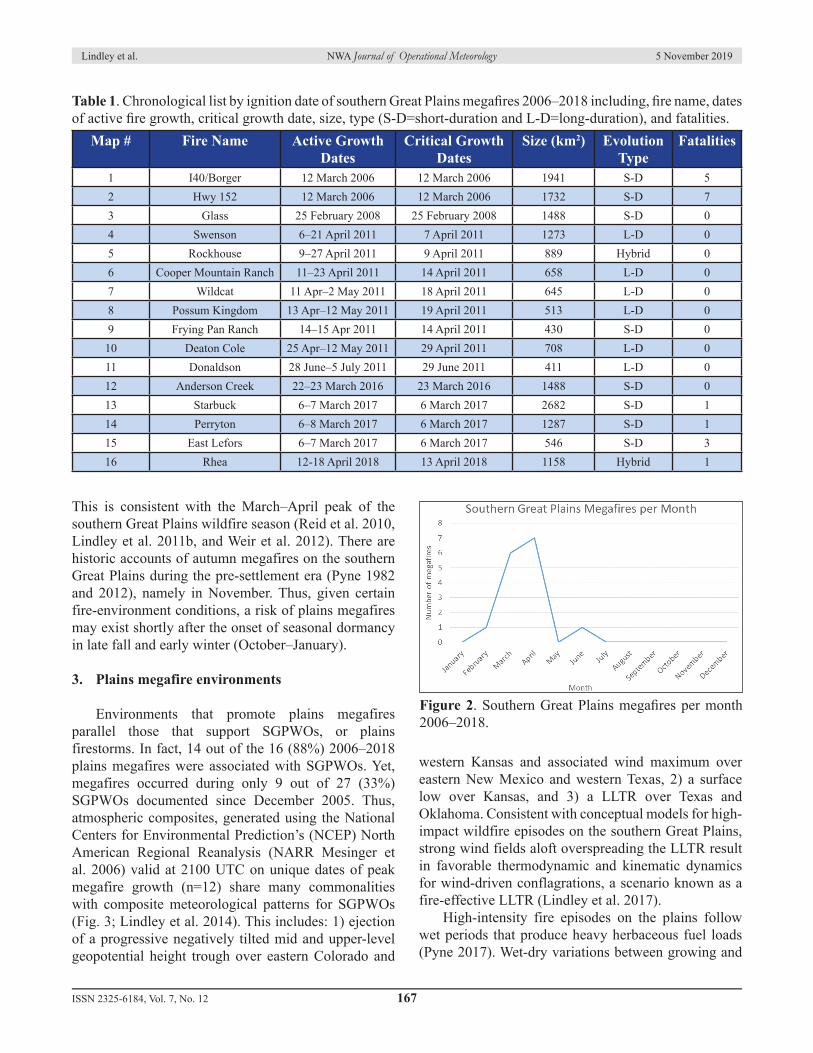
Fire data from the GeoMAC Wildland Fire Support system (USGS 2019) for 2000–present) was used to identify megafires within the southern Great Plains physiographic region. A total of 16 southern Great Plains megafires were identified, all of which occurred between 2006 and 2018 (Fig. 1 and Table 1). Daily fire progressions and impacts for each megafire were derived from Incident Status Summaries ICS-209s (USDA 2019). Megafires in the dataset range from the prolific Rockhouse and McDonald Fires that burned for weeks (at times in complex terrain on the periphery of the plains) in southeastern New Mexico and southwestern Texas, to fires of record (with respect to size) in grass-dominated fuelscapes of Kansas, Oklahoma, and Texas that burned 1000s km2 in only one or two days, such as the I-40/Borger (part of the East Amarillo Complex) and Starbuck Fires. Geographically, these southern Great Plains megafires occurred west of the 98th meridian,
where predominant vegetation types transition from the forested Cross Timbers to the east, toward grass-dominated prairies further west. This wood-to-grassland transition zone has been described as a wildland fire analogy to “tornado alley” (Pyne 2017). The propensity for megafires in this corridor is an artifact of high-risk mixed vegetation types and poor accessibility for suppression in the low rolling plains topography east of the Caprock Escarpment. Half of the presented megafires occurred during the historic 2011 fire season, when more than 16 000 km2 (4x10⁶ ac) burned in Texas (TFS 2012 and Jones et al. 2013). In fact, six plains megafires (five carryover fires and one new ignition) actively burned during a single firestorm episode on 14–15 April 2011. In addition to burning areas ≥405 km2 (≥100 000 ac), the 2011 Texas megafires were noted to have subcontinental impacts (Pyne 2017) consistent with societal and economic megafire phenomena across geographic scales (Williams et al. 2011 and Tedim et al. 2018). More broadly, the 2006–2018 megafires on the southern Great Plains occurred (both ignited and spread to obtained megafire status) during the months of February through June (the June 2011 McDonald Fire persisted into early July), with a dramatic peak during the spring (Fig. 2).
Figure 1. Sixteen megafires on the southern Great Plains between 2006 and 2018. Megafires are labeled by chronology of occurrence (ignition date) and correspond to Table 1 listings. The Great Plains physiographic region is delineated (yellow line), 98th meridian and Caprock Escarpment (gray dash), and megafires within the southern Great Plains are depicted in red/yellow. Click image for an external version; this applies to all figures and tables hereafter.
Lindley et al. NWA Journal of Operational Meteorology 5 November 2019
This is consistent with the March–April peak of the southern Great Plains wildfire season (Reid et al. 2010, Lindley et al. 2011b, and Weir et al. 2012). There are historic accounts of autumn megafires on the southern Great Plains during the pre-settlement era (Pyne 1982 and 2012), namely in November. Thus, given certain fire-environment conditions, a risk of plains megafires may exist shortly after the onset of seasonal dormancy in late fall and early winter (October–January).
3. Plains megafire environments
Environments that promote plains megafires parallel those that support SGPWOs, or plains firestorms. In fact, 14 out of the 16 (88%) 2006–2018 plains megafires were associated with SGPWOs. Yet, megafires occurred during only 9 out of 27 (33%) SGPWOs documented since December 2005. Thus, atmospheric composites, generated using the National Centers for Environmental Prediction’s (NCEP) North American Regional Reanalysis (NARR Mesinger et al. 2006) valid at 2100 UTC on unique dates of peak megafire growth (n=12) share many commonalities with composite meteorological patterns for SGPWOs (Fig. 3; Lindley et al. 2014). This includes: 1) ejection of a progressive negatively tilted mid and upper-level geopotential height trough over eastern Colorado and
western Kansas and associated wind maximum over eastern New Mexico and western Texas, 2) a surface low over Kansas, and 3) a LLTR over Texas and Oklahoma. Consistent with conceptual models for high-impact wildfire episodes on the southern Great Plains, strong wind fields aloft overspreading the LLTR result in favorable thermodynamic and kinematic dynamics for wind-driven conflagrations, a scenario known as a fire-effective LLTR (Lindley et al. 2017). High-intensity fire episodes on the plains follow wet periods that produce heavy herbaceous fuel loads (Pyne 2017). Wet-dry variations between growing and
Table 1. Chronological list by ignition date of southern Great Plains megafires 2006–2018 including, fire name, dates of active fire growth, critical growth date, size, type (S-D=short-duration and L-D=long-duration), and fatalities.
Map # Fire Name Active Growth Dates
Critical Growth Dates
Size (km2) Evolution Type
Fatalities
1 I40/Borger 12 March 2006 12 March 2006 1941 S-D 52 Hwy 152 12 March 2006 12 March 2006 1732 S-D 73 Glass 25 February 2008 25 February 2008 1488 S-D 04 Swenson 6–21 April 2011 7 April 2011 1273 L-D 05 Rockhouse 9–27 April 2011 9 April 2011 889 Hybrid 06 Cooper Mountain Ranch 11–23 April 2011 14 April 2011 658 L-D 07 Wildcat 11 Apr–2 May 2011 18 April 2011 645 L-D 08 Possum Kingdom 13 Apr–12 May 2011 19 April 2011 513 L-D 09 Frying Pan Ranch 14–15 Apr 2011 14 April 2011 430 S-D 010 Deaton Cole 25 Apr–12 May 2011 29 April 2011 708 L-D 011 Donaldson 28 June–5 July 2011 29 June 2011 411 L-D 012 Anderson Creek 22–23 March 2016 23 March 2016 1488 S-D 013 Starbuck 6–7 March 2017 6 March 2017 2682 S-D 114 Perryton 6–8 March 2017 6 March 2017 1287 S-D 115 East Lefors 6–7 March 2017 6 March 2017 546 S-D 316 Rhea 12-18 April 2018 13 April 2018 1158 Hybrid 1
Figure 2. Southern Great Plains megafires per month 2006–2018.
Lindley et al. NWA Journal of Operational Meteorology 5 November 2019
dormant seasons shape fuelscapes to promote both SGPWO and megafire potential (Lindley et al. 2014). Maximum monthly precipitation anomalies from the preceding growing season in proximity to each megafire were identified via National Oceanographic and Atmospheric Administration’s (NOAA) Advanced Hydrologic Prediction Service (McEnery et al. 2005, available online at water.weather.gov/precip/) archives, and ranged from 150% to 600% of normal with a median anomaly of 300% of normal precipitation (Fig. 4a). Subsequent dormant season anomalies immediately prior to each megafire ranged from 0% to 75% of normal, with a median of 10% of normal monthly precipitation (Fig. 4b). In 2010–2011, this wet-dry seasonal variation was characterized by widespread 200% to 400% of normal precipitation anomalies related to a remnant tropical system that impacted southeastern New Mexico, western Texas, and western Oklahoma in July 2010 (Fig. 5a, Vitale et al. 2015). The anomalous growing season precipitation was followed by drought prior to eight plains megafires that occurred between April and June 2011 (Fig. 5b). In order to further quantify and compare the vegetative fuel and weather environment associated with plains megafires, data were derived from Realtime Observation Monitoring and Analysis Network’s Remote Automated Weather Systems (Horel et al. 2004) and Automated Surface Observing System (NOAA 1998) networks respectively. To ensure that the data are representative of proximity fire environments on days of maximum megafire growth, or critical growth burn periods, multiple sites were considered when fires occurred between observations (n=20). Non-megafire producing SGPWOs (n=18) and megafire dead fuel
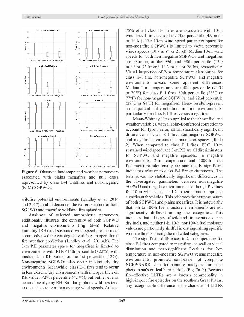
moisture parameter space (Fig. 6a–e) is similar and generally characterized by interquartile ranges ≤25th percentile values across the spectrum of time-lagged fuels (1-h, 10-h, 100-h, and 1000-h). Further analysis of null cases is provided by a sampling (n=899) of class E–I fires (1.2–40.5 km2 or 300–9999 ac; National Wildfire Coordinating Group, cited 2015), which occurred in a much broader range of fuel moisture conditions with interquartile dead fuel moistures that generally range from the 10th to 60th percentiles. The 1000-h dead fuel moisture interquartile range for megafire occurrence is broader than non-megafire SGPWOs, but the median megafire value is at the 9th percentile (12%) compared to 18th percentile (13%) for non-megafire SGPWOs. A similar signal is seen in ERC percentiles (Bradshaw et al. 1983). Here, class E–I fires again occur across the spectrum of ERC percentiles, and the interquartile range spans 60th to 90th percentile values. Comparatively, non-megafire SGPWOs and megafires occur exclusively when ERC exceeds the 75th to 80th percentiles and the median for non-megafire SGPWOs is 91st percentile and 98th percentile for megafires. This supports past statistical studies that suggest ERC has operational utility in identifying high significant
Figure 3. NCEP/NARR composites of the critical peak growth period for 2006–2018 southern Great Plains megafires, including: a) 500 hPa geopotential height (m), b) 500 hPa wind speed (m s–1), c) mean sea level pressure, and d) 2-m temperature (K).
Figure 4. Seasonal variation of precipitation anomalies associated with plains megafires shown via a) maximum monthly growing season percent of normal precipitation prior to and b) subsequent monthly percent of normal precipitation immediately preceding megafire occurrence.
Figure 5. Example of seasonal precipitation variability that supports megafire potential from 2010 to 2011. Locations of eight April–June 2011 plains megafires are indicated by flame icons.
Lindley et al. NWA Journal of Operational Meteorology 5 November 2019
wildfire potential environments (Lindley et al. 2014 and 2017), and underscores the extreme nature of both SGPWO and megafire wildland fire episodes. Analyses of selected atmospheric parameters additionally illustrate the extremity of both SGPWO and megafire environments (Fig. 6f–h). Relative humidity (RH) and sustained wind speed are the most commonly used meteorological variables in operational fire weather prediction (Lindley et al. 2011a,b). The 2-m RH parameter space for megafires is limited to environments with RHs ≤15th percentile (≤22%), with median 2-m RH values at the 1st percentile (12%). Non-megafire SGPWOs also occur in similarly dry environments. Meanwhile, class E–I fires tend to occur in less extreme dry environments with interquartile 2-m RH values ≤29th percentile (≤27%), but outlier events occur at nearly any RH. Similarly, plains wildfires tend to occur in stronger than average wind speeds. At least
75% of all class E–I fires are associated with 10-m wind speeds in excess of the 50th percentile (4.9 m s–1 or 10 kt). The 10-m wind speed parameter space for non-megafire SGPWOs is limited to >85th percentile winds speeds (10.7 m s–1 or 21 kt). Median 10-m wind speeds for both non-megafire SGPWOs and megafires are extreme, at the 99th and 98th percentile (17.0 m s–1 or 33 kt and 14.3 m s–1 or 28 kt), respectively. Visual inspection of 2-m temperature distribution for class E–I fire, non-megafire SGPWO, and megafire environments reveals some apparent differences. Median 2-m temperatures are 48th percentile (21°C or 70°F) for class E–I fires, 60th percentile (25°C or 77°F) for non-megafire SGPWOs, and 72nd percentile (29°C or 84°F) for megafires. These results represent an important differentiation in fire environments, particularly for class E-I fires versus megafires. Mann-Whitney U tests applied to the above fuel and weather variables, with a Holm-Bonferroni correction to account for Type I error, affirm statistically significant differences in class E–I fire, non-megafire SGPWO, and megafire environmental parameter spaces (Table 2). When compared to class E–I fires, ERC, 10-m sustained wind speed, and 2-m RH are all discriminators for SGPWO and megafire episodes. In megafire environments, 2-m temperature and 1000-h dead fuel moisture additionally are statistically significant indicators relative to class E-I fire environments. The tests reveal no statistically significant differences in the investigated parameters between non-megafire SGPWO and megafire environments, although P-values for 10-m wind speed and 2-m temperature approach significant thresholds. This reiterates the extreme nature of both SGPWOs and plains megafires. It is noteworthy that 1-h to 100-h fuel moisture environments are not significantly different among the categories. This indicates that all types of wildland fire events occur in dry fuels, and neither 1-h, 10-h, nor 100-h fuel moisture values are particularly skillful in distinguishing specific wildfire threats among the indicated categories. The significant differences in 2-m temperature for class E-I fires compared to megafires, as well as visual distribution and near-significant P-values for 2-m temperature in non-megafire SGPWO versus megafire environments, prompted comparison of composite NCEP/NARR 2-m temperature analyses for each phenomena’s critical burn periods (Fig. 7a–b). Because fire-effective LLTRs are a known commonality in high-impact fire episodes on the southern Great Plains, any recognizable difference in the character of LLTRs
Figure 6. Observed landscape and weather parameters associated with plains megafires and null cases represented by class E–I wildfires and non-megafire (N-M) SGPWOs.
Lindley et al. NWA Journal of Operational Meteorology 5 November 2019
associated with non-megafire SGPWOs versus megafire events may inform operational forecasting. Composites show no spatial variation in the location of a LLTR over the southern Great Plains for either non-megafire SGPWO or megafire episodes, but maximum 2-m temperatures associated with the LLTR in megafire cases are warmer (307 K/34°C/93°F) than those associated with non-megafire SGPWOs (305 K/32°C/90°F). While the average 2-m temperature difference between megafire and non-megafire SGPWO associated LLTRs is relatively small (2 K/2°C/3°F), the composite means comparatively suggest that megafires are generally associated with warmer LLTRs/temperatures than non-megafire SGPWOs.
4. Plains megafire evolution types
Large wildfires are also high-intensity fires (Pyne 2010), and are more difficult to control (Jensen and McPherson 2008). Thus, logic and conventional wisdom might suggest that such fires also tend to be of long duration. The largest megafires on the southern Great Plains, however, defy this reasoning. Southern Great Plains megafires documented here that exceed the upper quartile megafire size, or those that burned areas >75th percentile megafire size of 1337 km2 (330 447 ac), did so within active growth periods ≤48 h (Fig. 8). A majority (63%) of all plains megafires burned
areas ≥405 km2 (≥100 000 ac) within 24 h of ignition, although others persisted for up to 19 days with daily spread <405 km2 (<100 000 ac) throughout their duration. The mean plains megafire duration observed was five days, but notable variation in how plains megafires grow and behave prompted analysis of daily fire spread. Daily burn area was plotted throughout the duration of each megafire’s lifespan of active growth. Whereas the mean daily spread for plains megafires (Fig. 9a) reflects dramatic fire growth during initial burn periods with an average of 609 km2 (150 462 ac) burned within the initial 24-h, the analysis reveals two distinct modes of plains megafire evolution, as well as two fires that presented behavioral characteristics of both. Therefore, plains megafire evolution-types are described below as short-duration, long-duration, and hybrid. Predictive signals in both the weather and fuel environments can help forecasters and fire analysts identify incipient megafires, apply conceptual models to anticipated evolution and associated threats, and communicate those expectations to field practitioners so as to inform operational management strategies.
Figure 7. NCEP/NARR 2-m temperature (K) composites for a) non-megafire SGPWOs (n=18) and b) unique critical growth burn periods of the 2006–2018 southern Great Plains megafires (n=12).
Table 2. Mann-Whitney U test for significant differences between fuel and weather variables associated with class E–I fire, N-M SPGWO, and megafire parameter space. Significant P-values at the 95% confidence interval after a Holm-Bonferroni correction are indicated in red.
Mann-Whitney U Test for Class E-I, N-M SGPWO, and Megafire ParametersStatistical Difference ERC Wind Temp RH 1000-h 100-h 10-h 1-h
E–I versus N-M SGPWOs <0.001 <0.001 0.012 <0.001 0.004 0.011 0.042 0.173E–I versus Megafires <0.001 <0.001 <0.001 <0.001 0.002 0.002 0.084 0.111N-M SGPWOs versus
Lindley et al. NWA Journal of Operational Meteorology 5 November 2019
a. Short-duration megafires
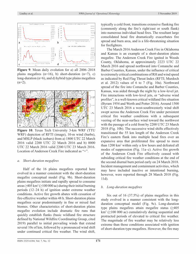
Half of the 16 plains megafires reported here evolved in a manner consistent with the short-duration megafire conceptual model (Fig. 9b). Short-duration plains megafires initiate and rapidly spread to consume areas ≥405 km2 (≥100 000 ac) during their initial burning periods (12–24 h) of ignition under extreme weather conditions. Active fire growth abates with cessation of fire-effective weather within 48 h. Short-duration plains megafires occur predominantly in fine or mixed fuel biomes. Other characteristics of short-duration plains megafire evolution include dramatic fire runs that quickly establish flanks (basic wildland fire structure defined by National Wildfire Coordinating Group, cited 2019) parallel to initial prevailing winds that extend several 10s of km, followed by a pronounced wind shift under continued critical fire weather. The wind shift,
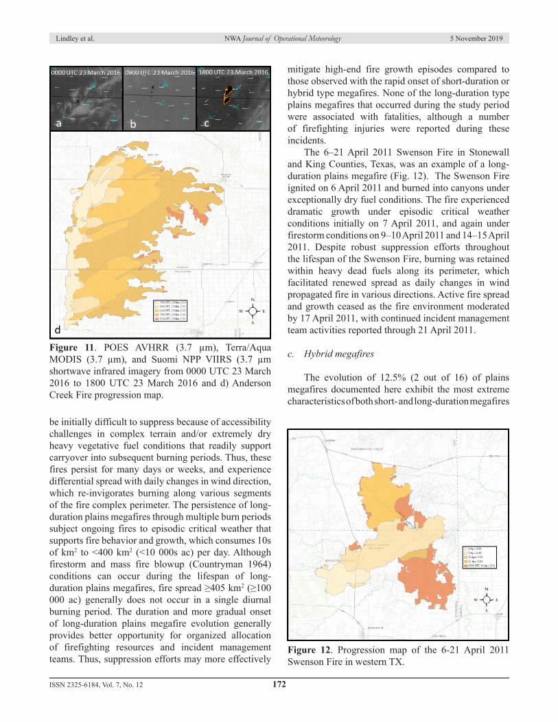
typically a cold front, transitions extensive flanking fire (commonly along the fire’s right/east or south flank) into numerous individual head fires. The resultant large consolidated head fire dramatically exacerbates fire spread and burn area, and is a life-threatening situation for firefighters. The March 2016 Anderson Creek Fire in Oklahoma and Kansas is an example of a short-duration plains megafire. The Anderson Creek Fire ignited in Woods County, Oklahoma, at approximately 2223 UTC 22 March 2016 and spread northward into Comanche and Barber Counties, Kansas, under the influence of critical to extremely critical combinations of RH and wind speed as indicated by Red Flag Threat Index (RFTI; Murdoch et al. 2012) values of 6 to 7 (Fig. 10a). Northward spread of the fire into Comanche and Barber Counties, Kansas, was aided through the night by a low-level jet. Fire interactions with low-level jets, or “adverse wind profiles”, is a well-known critical wildland fire situation (Byram 1954 and Werth and Potter 2016). Around 1500 UTC 23 March 2016 a west-southwesterly wind shift swept across the Anderson Creek Fire under persistent critical fire weather conditions with a subsequent veering of the near-surface wind toward the northwest with the passage of a cold front by 2200 UTC 23 March 2018 (Fig. 10b). The successive wind shifts effectively transitioned the 55 km length of the Anderson Creek Fire’s eastern flank into multiple head fires over an expansive area that proliferated fire spread to more than 1200 km2 within only a few hours and defeated all modes of suppression (Fig. 11a–c). Active fire growth of the Anderson Creek Fire effectively ceased with subsiding critical fire weather conditions at the end of the second diurnal burn period early on 24 March 2018. Incident management and containment activities, which may have included inactive or intentional burning, however, were reported through 28 March 2018 (Fig. 11d).
b. Long-duration megafires
Six out of 16 (37.5%) of plains megafires in this study evolved in a manner consistent with the long-duration conceptual model (Fig. 9c). Long-duration type plains megafires attain megafire status (≥405 km2 (≥100 000 ac) cumulatively during sequential and protracted periods of elevated to critical fire weather. The magnitude of fire weather may be relatively less extreme than those conditions associated with ignition of short-duration type megafires. However, the fire may
Figure 9. Mean daily evolution for a) all 2006–2018 plains megafires (n=16), b) short-duration (n=7), c) long-duration (n=6), and d) hybrid type plains megafires (n=2).
Figure 10. Texas Tech University 3-km WRF (TTU WRF) depiction of RFTI (image), 10-m wind (barbs), and MSLP (black isobars) from a) 1800 UTC 22 March 2016 valid 2200 UTC 22 March 2016 and b) 0000 UTC 22 March 2016 valid 2200 UTC 23 March 2016. Location of Anderson Creek Fire indicated as “+”.
Lindley et al. NWA Journal of Operational Meteorology 5 November 2019
be initially difficult to suppress because of accessibility challenges in complex terrain and/or extremely dry heavy vegetative fuel conditions that readily support carryover into subsequent burning periods. Thus, these fires persist for many days or weeks, and experience differential spread with daily changes in wind direction, which re-invigorates burning along various segments of the fire complex perimeter. The persistence of long-duration plains megafires through multiple burn periods subject ongoing fires to episodic critical weather that supports fire behavior and growth, which consumes 10s of km2 to <400 km2 (<10 000s ac) per day. Although firestorm and mass fire blowup (Countryman 1964) conditions can occur during the lifespan of long-duration plains megafires, fire spread ≥405 km2 (≥100 000 ac) generally does not occur in a single diurnal burning period. The duration and more gradual onset of long-duration plains megafire evolution generally provides better opportunity for organized allocation of firefighting resources and incident management teams. Thus, suppression efforts may more effectively
mitigate high-end fire growth episodes compared to those observed with the rapid onset of short-duration or hybrid type megafires. None of the long-duration type plains megafires that occurred during the study period were associated with fatalities, although a number of firefighting injuries were reported during these incidents. The 6–21 April 2011 Swenson Fire in Stonewall and King Counties, Texas, was an example of a long-duration plains megafire (Fig. 12). The Swenson Fire ignited on 6 April 2011 and burned into canyons under exceptionally dry fuel conditions. The fire experienced dramatic growth under episodic critical weather conditions initially on 7 April 2011, and again under firestorm conditions on 9–10 April 2011 and 14–15 April 2011. Despite robust suppression efforts throughout the lifespan of the Swenson Fire, burning was retained within heavy dead fuels along its perimeter, which facilitated renewed spread as daily changes in wind propagated fire in various directions. Active fire spread and growth ceased as the fire environment moderated by 17 April 2011, with continued incident management team activities reported through 21 April 2011.
c. Hybrid megafires
The evolution of 12.5% (2 out of 16) of plains megafires documented here exhibit the most extreme characteristics of both short- and long-duration megafires
Figure 11. POES AVHRR (3.7 µm), Terra/Aqua MODIS (3.7 µm), and Suomi NPP VIIRS (3.7 µm shortwave infrared imagery from 0000 UTC 23 March 2016 to 1800 UTC 23 March 2016 and d) Anderson Creek Fire progression map.
Figure 12. Progression map of the 6-21 April 2011 Swenson Fire in western TX.
Lindley et al. NWA Journal of Operational Meteorology 5 November 2019
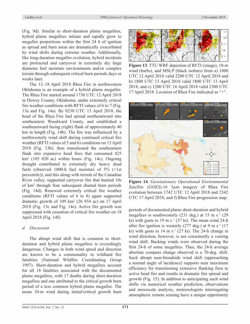
(Fig. 9d). Similar to short-duration plains megafires, hybrid plains megafires initiate and rapidly grow to megafire proportions within the first 24 h of ignition as spread and burn areas are dramatically exacerbated by wind shifts during extreme weather. Additionally, like long-duration megafire evolution, hybrid incidents are protracted and carryover in extremely dry large diameter fuel moisture environments and/or complex terrain through subsequent critical burn periods days or weeks later. The 12–18 April 2018 Rhea Fire in northwestern Oklahoma is an example of a hybrid plains megafire. The Rhea Fire started around 1730 UTC 12 April 2018 in Dewey County, Oklahoma, under extremely critical fire weather conditions with RFTI values of 6 to 7 (Fig. 13a and Fig. 14a). By 0230 UTC 13 April 2018, the head of the Rhea Fire had spread northeastward into southeastern Woodward County, and established a southeastward facing (right) flank of approximately 40 km in length (Fig. 14b). The fire was influenced by a northwesterly wind shift during continued critical fire weather (RFTI values of 5 and 6) conditions on 13 April 2018 (Fig. 13b), then transitioned the southeastern flank into expansive head fires that consumed 425 km2 (105 020 ac) within hours (Fig. 14c). Ongoing drought contributed to extremely dry heavy dead fuels (observed 1000-h fuel moisture of 5% (<1st percentile)), and this along with terrain of the Canadian River valley, supported carryover fire that burned 10s of km2 through four subsequent diurnal burn periods (Fig. 14d). Renewed extremely critical fire weather conditions (RFTI values of 6 to 8) again supported dramatic growth of 109 km2 (26 934 ac) on 17 April 2018 (Fig. 13c and Fig. 14e). Active fire growth was suppressed with cessation of critical fire weather on 18 April 2018 (Fig. 14f).
d. Discussion
The abrupt wind shift that is common to short-duration and hybrid plains megafires is exceedingly dangerous. Changes in both wind speed and direction are known to be a commonality in wildland fire fatalities (National Wildfire Coordinating Group 1997). Short-duration and hybrid megafires account for all 18 fatalities associated with the documented plains megafires, with 17 deaths during short-duration megafires and one attributed to the critical growth burn period of a less common hybrid plains megafire. The mean 10-m wind during initial/critical growth burn
periods of documented plains short-duration and hybrid megafires is southwesterly (231 deg.) at 15 m s–1 (29 kt) with gusts to 19 m s–1 (37 kt). The mean wind 24-h after fire ignition is westerly (277 deg.) at 9 m s–1 (17 kt) with gusts to 14 m s–1 (27 kt). The 24-h change in wind direction, however, is not consistently a veering wind shift. Backing winds were observed during the first 24-h of some megafires. Thus, the 24-h average absolute compass change observed is a 70-deg. shift. Such abrupt near-broadside wind shift (approaching a normal angle of incidence) supports near maximum efficiency for transitioning extensive flanking fires to active head fire and results in dramatic fire spread and growth (Fig. 15). In addition to anticipating such wind shifts via numerical weather prediction, observations and mesoscale analysis, meteorologists interrogating atmospheric remote sensing have a unique opportunity
Figure 13. TTU WRF depiction of RFTI (image), 10-m wind (barbs), and MSLP (black isobars) from a) 1800 UTC 12 April 2018 valid 2200 UTC 12 April 2018 and b) 1800 UTC 13 April 2018 valid 1800 UTC 13 April 2018, and c) 1200 UTC 16 April 2018 valid 2300 UTC 17 April 2018. Location of Rhea Fire indicated as “+”.
Figure 14. Geostationary Operational Environmental Satellite (GOES)-16 3µm imagery of Rhea Fire evolution between 1742 UTC 12 April 2018 and 2342 UTC 17 April 2018, and f) Rhea Fire progression map.
Lindley et al. NWA Journal of Operational Meteorology 5 November 2019
to identify such threats to firefighter safety and provide tactical support in advance of approaching wind shifts and other weather-related hazards that influence fire behavior (Murdoch et al. 2016 and Lindley et al. 2018).In addition to fire/wind shift interactions, heavy dead fuel moisture influences megafire potential and mode (Fig. 16). Short-duration plains megafires are associated with unusually dry ambient vegetation conditions across the fuel spectrum and are limited to 1000-h fuel moistures ≤40th percentile (17%). This type of megafire evolution, however, is more dependent upon extreme weather conditions that facilitate rapid fire spread rates through fine fuels and is exacerbated by abrupt wind shifts favorably oriented for dramatic increases in fire size. On the other hand, long-duration and hybrid plains megafires occur exclusively in extremely dry heavy dead fuel environments characterized by 1000-h fuel moisture ≤10th percentile (≤12%). This underscores the role of heavy, or large diameter, vegetative fuel components in facilitating carryover for the development of protracted, long-duration and hybrid type megafires.Thus, the forecast magnitude of combined weather and fuel fire environment conditions, including the timing and orientation of potential fire/wind shift interactions, can aid in operational prediction of plains megafire development and evolution. The median fuelscape and weather parameter space for plains megafires and discriminators for megafire evolution type are summarized in Tables 3 and 4. The application of such knowledge allowed forecasters in the southern Great Plains to successfully predict megafire evolution in April 2018. An experimental significant wildfire forecast issued by a collaborative interagency working group of National Weather Service meteorologists and fire analysts from Texas and Oklahoma state forestry agencies issued at 1527 UTC 11 April 2018 stated “Dangerous fire episode on the Southern Plains
Thursday-Friday [12–13 April 2018]. Greatest concern is for ignition of significant fire Thursday [12 April 2018] afternoon in vicinity of northwestern Oklahoma which will be hit by strong wind shift during peak burning period Friday [13 April 2018]”. Once wildfires ignited on 12 April 2018, subsequent outlooks focused on the anticipated passage of a cold front to specify that “the 34 [Complex] and Rhea Fires are megafire candidates” at 1221 UTC 13 April 2018. It is important to note that not all wildland fires within the indicated environmental conditions will become megafires. Ultimately, megafire development is conditionally dependent upon a number of circumstances that include fire ignition in areas of abundant high-risk fuels, complex topography, or other suppression resource limitations. Although physical factors such as weather/climate and fuels alone may not completely account for the occurrence of megafires (Pyne 2010), damaging wildfire episodes (e.g., SGPWOs and megafires) require certain infrequent combinations of rarely coincident and short-lived weather and fuel conditions that are outside the normal constraints of the plains fire regime (Brotack and Reifsnyder 1977 and Pyne 2012). The environmental conditions documented in this study provide a quantified survey of the combined weather and fuel parameter space supportive of the 2006–2018 plains megafires.
Figure 15. Conceptual model for plains megafire evolution per wind shift interaction and real-world example via NASA MODIS Aqua imagery of the Anderson Creek Fire on 23 March 2016.
Figure 16. a) Plains megafire duration versus 1000-h fuel moisture percentile and 1000-h fuel moisture percentile for b) short-duration plains megafires compared to c) long-duration and hybrid megafires.
Megafires on the southern Great Plains are associated with unusually dry vegetative fuels and extreme fire weather conditions in a narrow environmental parameter space. Analyses of 16 megafire environments between 2006 and 2018 on the plains of New Mexico, Texas, Oklahoma and Kansas reveal three modes of megafire evolution. Short-duration megafires ignite and consume >405 km2 within 24-h under extreme weather conditions, with dramatic exacerbation of fire spread associated with the passage of a wind shift and then a cessation of active growth within 48-h of initiation. Long-duration megafires, which ignite under less intense weather conditions but persist with carryover in rough terrain and/or in extremely dry heavy dead fuel moisture (1000-h fuels) through many diurnal burn periods, account for 40–400 km2 (10 000s ac) per day as changing wind directions promote differential fire spread. Hybrid megafires, which demonstrate the most extreme characteristics of both short- and long-duration incidents by burning ≥405 km2 (≥100 000) within the initial 24 h under extreme conditions, are exacerbated by a wind shift and then persist in extremely dry heavy fuels and/or complex terrain through subsequent days/weeks that include additional critical or extreme burning periods. Although these evolutionary-types describe classifications of megafires observed on the southern Great Plains, analogous megafire growth and behavior likely occurs in the American West. For example, megafires associated with downslope windstorms in California likely evolve similarly to short-duration plains megafires, and long-duration plains megafires
are likely a variant of timber-dominant megafires in western forests. On the southern Great Plains, however, the occurrence of megafires is closely tied to SGPWOs, with 88% associated with firestorm conditions. As such, atmospheric composites for the peak burning period of the 16 megafire cases documented here strongly resemble those known to support plains fire outbreaks. These composites are characterized by the passage of a midlatitude cyclone over the southern and central Great Plains with an associated strong midlevel wind speed maximum overspreading a LLTR. Yet, only 33% of SGPWOs documented since 2005 were associated with megafires. Severity of the combined weather and fuel fire environment, as well as the timing, magnitude and angle of incidence of wind shifts, provide predictive indicators for megafire potential. The conceptual models presented here have already proven to provide operational value in predictive services that translate toward strategic fire management (Table 5). It is hoped that additional knowledge and future forecasts continue to improve toward effective influences on firefighter and public safety.
Acknowledgments: The authors would like to thank the following individuals who have assisted and/or supported this research: David Andra, Richard Smith, Ryan Barnes, Vivek Mahale, Scott Curl, Mark Goeller, Andy James, Brian Curran, Denver Ingram, J. J. Brost, Greg Patrick, Robyn Heffernan, Stephen Creech, and Chris Gitro, and Israel Jirak. The authors extend a
ISSN 2325-6184, Vol. 7, No. 12 175
Lindley et al. NWA Journal of Operational Meteorology 5 November 2019
Table 3. Median plains megafire environmental parameter space for critical growth burn period.Median Plains Megafire Environmental Parameter Space (Critical Growth Burn Period)
Landscape Weather1000-h Fuel Moisture 9th Percentile (12%) 2-m RH 1st Percentile (12%)ERC* 98th Percentile* 10-m Wind Speed 98th Percentile (14.3 m s-1, 28 kt)* specific values are location dependent 2-m Temperature 72nd Percentile (29ºC, 84ºF)
Abrupt Near-Broadside Wind Shift 1000-h Fuel MoistureS-D Y ≤40th Percentile (17%)L-D N-but varies on daily timescales ≤10th Percentile (12%)
Hybrid Y ≤10th Percentile (12%)+ Conditional on favorable megafire environment and candidate fires
special thanks to the three reviewers, especially to Dr. Stephen Pyne whose body of work has informed and inspired our efforts in plains fire meteorology for many years.
_____________________
REFERENCES
Balch, J. K., B. A. Bradley, J. T. Abatzoglou, R. C. Nagy, E. J. Fusco, and A. L. Mahood, 2017: Human-started wildfires expand the fire niche across the United States. Proc. Natl. Acad. Sci. U.S.A., 114 (11), 2946-2951, CrossRef.Barnes, R. R., and T. T. Lindley, 2018: Predicting probabilities of wildland fire intensity using parametric and nonparametric statistical modeling methods. 12th Symp. on Fire and Forest Meteorology, Boise, ID, Amer. Meteor. Soc., P35. [Abstract available online at ams.confex.com/ams/33AF12F4BG/meetingapp.cgi/ Paper/343868].
Binkley, D., 2012: Exploring the Mega-Fire Reality 2011: the Forest Ecology and Management Conference. Fire Management Today 72 (3):15-17. [Available online at www.fs.fed.us/sites/default/files/legacy_files/fire- management-today/72-3_0.pdf].Bradshaw, L. S., R. E. Burgan, J. D. Cohen, and J. E. Deeming, 1983: The 1978 national fire danger rating system: Technical documentation. USDA Forest Service Rep. INT-169, 44 pp. [Available online at www.fs.fed. us/rm/pubs_int/int_gtr169.pdf].Briggs, J. M., A. K. Knapp, J. M. Blair, et. al, 2005: An ecosystem in transition: causes and consequences of the conversion of mesic grassland to shrubland. BioScience, 55, 243-54. CrossRef.Brotak, E. A. and W. E. Reifsnyder, 1977: An investigation of the synoptic situations associated with major wildland fires. J. Appl. Meteor., 16, 867–870. CrossRef.
ISSN 2325-6184, Vol. 7, No. 12 176
Lindley et al. NWA Journal of Operational Meteorology 5 November 2019
Table 5. Decisional aid for fire management strategy impacts per megafire evolution-type.Plains Megafire Evolution-Type & Fire Management Impact Matrix
Megafire Type AnalogCharacteristics of Megafire
Evolution-Type Guidance for Fire Management Impact Life/Safety Threat
S-DAnderson
Creek
• Short duration ≤48 h• Rapid rates of spread• Dependent upon extremely critical fire weather• Abrupt wind shift• Weather improves following wind shift
• High resource mobilization• Defensive tactics in initial extremely critical weather• Transition to offensive tactics following wind shift• Variable complexity (Type III–Type I)• Rapidly changing incident complexity
High
L-D Swenson
• Extended duration 3–19 days• Episodic critical fire weather• Extremely dry heavy fuels/drought• Complex topography• Large growth days separated in time
• Extreme resource mobilization• Mixed-mode tactics with accessibility concerns• Persistent threats to control lines• High complexity (Type II–Type I)• Potential Incident Management Team
Moderate
Hybrid Rhea
• Rapid rates of spread initial 48-h• Extended duration 3–19 days• Initial extremely critical fire weather• Abrupt wind shift• Fire spreads into heavy fuel/complex topography• Additional large growth days possible
• Extreme resource mobilization• Defensive tactics in initial extremely critical weather• Transition to mixed-mode (offensive, defensive, and point protection) tactics• Persistent threats to control lines• High complexity (Type II–Type I)• Potential Incident Management Team
Byram, G. M., 1954: Atmospheric conditions related to blowup fires. Station Paper SE-SP-35. United States Depart. Of Agric.–Forest Service, Southeastern Forest Experiment Station, Asheville, NC, 36 pp. [Available online at www.fs.usda.gov/treesearch/pubs/45778].Countryman, C. M., 1964: Mass fires and fire behavior. Res. Paper RS-RP-19. Pac. Southwest Forest and Range Exp. Station, Berkeley, CA, 53 pp. [Available online at www. fs.usda.gov/treesearch/pubs/28733].Courtwright, J., 2011: Prairie fire: a Great Plains history. University of Kansas Press. Lawrence, KS, 288 pp. [Available online at kansaspress. ku.edu/978-0-7006-1794-4.html].Dennison, P. E., S. C. Brewer, J. D. Arnold, and M. A. Moritz, 2014: Large wildfire trends in the western United States, 1984-2011. Geophys. Res Lett., 41, 2928-2933. CrossRef.Donovan, V.M., C. L. Wonkka, and D. Twidwell, 2017: Surging wildfire activity in a grassland biome. Geophys. Res. Lett., 44, 5986–5993. CrossRef.Engle, D. M., B. R. Coppedge, and S. D. Fuhlendorf, 2008: From the dust bowl to the green glacier: human activity and environmental change in Great Plains grasslands. In Western North American Juniperus Communities, edited by O. W. Van Auken, 196, 253-271. CrossRef. French, B. J., L. D. Prior, G. J. Williamson, D. M. J. S. Bowman, 2016: Cause and effects of megafire in sedge- heathland in the Tasmanian temperate wilderness. Aust. J. Bot. 64, 513-525. CrossRef.Frost, C. C., 1998: Presettlement fire frequency regimes of the United States: a first approximation. Fire in ecosystem management: shifting the paradigm from suppression to prescription, Proc. of the 20th Tall Timbers Fire Ecology Conf., Tall Timbers Research Station, Tallahassee, FL. [Available online at talltimbers.org/wp- content/uploads/2018/09/70-Frost1998_op.pdf].Gabbert, B., 2015: Preliminary data indicates there have been 18 megafires this year. Wildfire Today October 7, 2015. [Available online at wildfiretoday.com/2015/10/07/ preliminary-data-indicates-there-have-been-18- megafires-this-year/].Guyette, R. P., M. C. Stambaugh, D. C. Dey, and R.–M. Muzika, 2012: Predicting fire frequency with chemistry and climate. Ecosystems, 15 (2), 322-335. CrossRef.Heyck-Williams, S., L. Anderson, and B. A. Stein, 2017: Megafires: the growing risk to America’s forests, communities, and wildlife. Washington, DC: National Wildlife Federation. [Available online at www.nwf.org/ megafires-report]
Horel, J., M. Splitt, J. Pechmann, B. Olsen, and E. Delgado, 2004: ROMAN - Realtime Observation Monitoring and Analysis Network. 20th Inter. Conf. on Interactive Information and Processing Systems (IIPS) for Meteorology, Oceanography, and Hydrology, Amer. Meteor. Soc., Seattle, WA, 9.10. [Available online at ams.confex.com/ams/pdfpapers/70125.pdf].Jensen, S. E. and G. R. McPherson, 2008: Living with fire: fire ecology and policy for the Twenty-First Century. University of California Press, Los Angeles, CA, 192 pp. [Available online at www.ucpress.edu/ book/9780520255890/living-with-fire].Jones, J., A. Saginor, and B. Smith, 2013: 2011 Texas wildfires: common denominators of home destruction. Texas A&M Forest Service, 50 pp. [Available online at tfsweb.tamu.edu/uploadedFiles/TFSMain/Preparing_ for_Wildfires/Prepare_Your_Home_for_Wildfires/ Contact_Us/2011%20Texas%20Wildfires.pdf].Lindley, T. T., G. D. Skwira, G. P. Murdoch, and J. L. Guyer, 2011a: Preliminary meteorological analysis of the 2011 “Texas firestorms”. 9th Symp. on Fire and Forest Meteorology, Palm Springs, CA, Amer. Meteor. Soc., 2.2. [Available online at ams.confex.com/ams/9FIRE/ webprogram/Manuscript/Paper192218/2.2.pdf].____, J. D. Vitale, W. S. Burgett, and M.-J. Beierle, 2011b: Proximity meteorological observations for wind- driven grassland wildfire starts on the southern High Plains. Electronic J. Severe Storms Meteor., 6 (1), 1–27. [Available online at www.ejssm.org/ojs/index.php/ ejssm/article/download/67/61].____, G. P. Murdoch, B. R. Smith, K. M. Van Speybroeck, 2013a: Environmental factors contributing the emergence of southern Great Plains wildfire outbreaks. 10th Symp. on Fire and Forest Meteorology, Bowling Green, KY, Amer. Meteor. Soc., P4. [Available online at ams.confex.com/ams/10Fire/webprogram/ Paper229314.html].____, G. P. Murdoch, and B. R. Smith, 2013b: Firestorm: the anatomy of a southern Great Plains wildfire outbreak. 10th Symp. on Fire and Forest Meteorology, Bowling Green, KY, Amer. Meteor. Soc., P3. [Available online at ams.confex.com/ams/10Fire/webprogram/ Paper229313.html].____, G. P. Murdoch, J. L. Guyer, G. D. Skwira, K. J. Schneider, S. R. Nagle, K. M. Van Speybroeck, B. R. Smith, and M.-J. Beierle, 2014: Southern Great Plains wildfire outbreaks. Electronic J. Severe Storms Meteor., 9 (2), 1–43. [Available online at www.ejssm.org/ojs/ index.php/ejssm/article/download/132/98].____, B. R. Bowers, G. P. Murdoch, B. R. Smith, and C. M. Gitro, 2017: Analyses of fire-effective low-level thermal ridges on the southern Great Plains. J. Operational Meteor., 5 (12), 146-160. CrossRef.
ISSN 2325-6184, Vol. 7, No. 12 177
Lindley et al. NWA Journal of Operational Meteorology 5 November 2019
____, G. P. Murdoch, R. Heffernan, L. Van Bussum, A. E. Gerard, N. J. Nauslar, 2018: An impact-based decision support paradigm for National Weather Service wildfire forecast & warning services. 12th Symp. on Fire and Forest Meteorology, Boise, ID, Amer. Meteor. Soc., P36. [Available online at ams.confex.com/ams/33AF12F4BG/ mediafile/Manuscript/Paper343869/Lindley_2018.pdf]McEnery, J., J. Ingram, Q. Duan, T. Adams, and L. Anderson, 2005: NOAA’s Advanced Hydrologic Prediction Service: building pathways for better science in water forecasting. Bull. Amer. Meteor. Soc., 86, 375–385. CrossRef.Mesinger, F., and Coauthors, 2006: North American regional reanalysis. Bull. Amer. Meteor. Soc., 87, 343–360. CrossRef.Mirik, M., and R. J. Ansley, 2012: Utility of satellite and aerial images for quantification of canopy cover and infilling rates of the invasive woody species Honey Mesquite (Prosopis Glandulosa) on rangeland. Remote Sensing, 4 (7), 1947-1962. CrossRef. Murdoch, G. P., R. R. Barnes, C. M. Gitro, T. T. Lindley, and J. D. Vitale, 2012: Assessing critical fire weather conditions using a red flag threat index. Electronic J. Operational Meteor., 13 (4), 46−56. [Available online at nwafiles.nwas.org/ej/pdf/2012-EJ4.pdf].____, T. T. Lindley, and C. J. Morris 2016: A Doppler radar and conceptual analysis of horizontal longitudinal vortex influencing the Bastrop Complex wildfire. J. Operational Meteor., 4 (12), 160-169. CrossRef.National Wildfire Coordinating Group, 1997: Historical wildland firefighter fatalities 1910-1996. National Interagency Fire Center, PMS #822, NFES #1849. 45 pp. [Available online at www.yumpu.com/en/document/ view/11660608/historical-wildland-firefighter-fatalities- 1910-1996-national-]____, cited 2015: Data element standard, fire size class. [Available online at www.nwcg.gov/data-standards/fire- size-class].____, cited 2019: Head, flank, and rear fire terms. [Available online at www.nwcg.gov/course/ffm/fire-behavior/86- head-flank-and-rear-fire-terms].NIFC, cited 2018: “The definition of a megafire is a wildfire that has burned 100,000 acres or more.” Facebook, 7 October 2015. [Available online at www.facebook.com/ BLMFire/posts/1002825379774932].NOAA, 1998: Automated Surface Observing System (ASOS) User’s Guide. Tech. Rep., National Oceanic and Atmospheric Administration, 74 pp. [Available online at www.nws.noaa.gov/asos/pdfs/aum-toc.pdf].Pyne, S. J., 1982: Fire in America. University of Washington Press. Seattle, WA. [1997 Edition available at uwapress. uw.edu/book/9780295975924/fire-in-america/].
____, 2007a: Megaburning: the meaning of megafires and the means of their management. 4th Inter. Conf. on Wildland Fire, Seville, Spain. [Available online at gfmc.online/ s e v i l l a - 2 0 0 7 / c o n t r i b u t i o n s / d o c / c d / INTRODUCTORIAS_ST/Pyne_ST1.pdf].____, 2007b: Problems, paradoxes, paradigms: triangulating fire research. Inter. J. of Wildland Fire. 16 (3), 271-276. CrossRef.____, 2010: America’s fires: a historical context for policy and practice. Forest History Society, Durham, NC, 94 pp. [Available online at foresthistory.org/issues/ americas-fires-historical-context-policy-practice/].____, 2012: Fire: Nature and Culture. Reaktion Books Ltd., London, UK, 208 pp. [Available online at reaktionbooks. co.uk/display.asp?K=9781780230467].____, 2017: The Great Plains: A Fire Survey. The University of Arizona Press, Tucson, AZ, 217 pp. [Available online at uapress.arizona.edu/book/the-great-plains].Reid, A. M., S. D. Fuhlendorf, and J. R. Weir. 2010: Weather variables affecting Oklahoma wildfires. Rangeland Ecology & Management, 63(5), p. 599-603. CrossRef. TFS 2012: TFS newsroom: Current Texas wildfire situation. [Current similar product available online at tfsweb.tamu. edu/CurrentSituation/].Tedim, F., and Coauthors, 2018: Defining extreme wildfire events: difficulties, challenges, and impacts. Fire, 1(1):9. CrossRef.Twidwell, D., W. E. Rogers, S. D. Fuhlendorf, C. L. Wonkka, D. M. Engle, J. R. Weir, U. P. Kreuter, and C. A. Taylor Jr., 2013: The rising Great Plains fire campaign: citizen’s response to woody plant encroachment. CrossRef.United States Department of Agriculture (USDA), accessed 2019: National Fire and Aviation Management Web Applications (FAMWEB). [Available online at: fam. nwcg.gov/fam-web/].United States Geological Survey (USGS), accessed 2019: Geospatial Multi-Agency Coordination (GeoMAC) website. [Available online at www.geomac.gov/].Vitale, J. D., J. Lipe, and T. T. Lindley, 2015: Independence Day holiday weekend 2010 flood on the southern plains of West Texas. J. Operational Meteor., 3 (7), 70-81. CrossRef.Weir, J. R., A. M. Reid, and S. D. Fuhlendorf. 2012. Wildfires in Oklahoma. Oklahoma Div. of Agric. Sci. and Natural Res. v. NAREM2888-2. [Available online at: www. ok.gov/conservation/documents/WildfiresinOklahoma. pdf]Werth, P. A., Coauthors, 2016: Synthesis of knowledge of extreme fire behavior: volume 2 for fire behavior specialists, researchers, and meteorologists. PNW- GTR-891, USDA Forest Service, Pacific Northwest Research Station, Portland, Oregon. [Available online at www.fs.usda.gov/treesearch/pubs/50530].
ISSN 2325-6184, Vol. 7, No. 12 178
Lindley et al. NWA Journal of Operational Meteorology 5 November 2019
Williams, J., L. Hamilton, R. Mann, M. Rounsaville, H. Leonard, O. Daniels, and D. Bunnell, 2005: The mega-fire phenomenon: toward a more effective management model. The Brookings Institution, Washington, DC. [Available online at: www.bushfirecrc.com/sites/ default/files/managed/resource/mega-fire_concept_ paper_september_20_2005.pdf].____, and Coauthors, 2011: Findings and implications from a course-scale global assessment of recent selected mega-fires. 5th Inter. Wildland Fire Conf., Sun City, South Africa. [Available online at www.fao.org/forestry/32063- 0613ebe395f6ff02fdecd13b7749f39ea.pdf].____, 2013: Exploring the onset of high-impact mega-fires through a forest land management prism. For. Ecol. Manag. 294, 4-10. CrossRef.Wright, H. A., and Bailey, A. W. 1982: Fire Ecology— United States and Southern Canada. John Wiley and Sons, 528 pp. [Available online at www.wiley.com/en- us/Fire+Ecology%3A+United+States+and+Southern+ Canada-p-9780471090335].
ISSN 2325-6184, Vol. 7, No. 12 179
Lindley et al. NWA Journal of Operational Meteorology 5 November 2019