19
MEMBER REPORT United States of America Pacific Region ESCAP/WMO Typhoon Committee 15th Integrated Workshop 1-2 December 2020

MEMBER REPORT United States of America
Pacific Region
ESCAP/WMO Typhoon Committee 15th Integrated Workshop
1-2 December 2020

_______________________________________ Cover caption: WFO Guam’s graphic based on the first warning issued by the Joint Typhoon Warning Center (JTWC) for Super Typhoon Goni (22W). Goni brushed by the Mariana Islands as a tropical disturbance before intensifying rapidly west of the islands in the Philippine Sea. This behavior was typical of that observed during the 2020 La Nina Year, where nearly all the tropical disturbances that passed through the WFO Guam Area of Responsibility (AOR) only organized once they moved west of or along the edge of the western boundary of the AOR. The figure is from the Emergency Management software program, HURREVAC. HURREVAC is the decision support tool of the National Hurricane Program, administered by the Federal Emergency Management Agency (FEMA), the US Army Corps of Engineers (ACE), and the NOAA National Hurricane Center. The satellite images were overlaid onto the HURREVAC graphic.
I. Overview of tropical cyclones which have affected/impacted Member’s area since the last Committee Session The Pacific Region of the United States of America (USA) National Oceanic and Atmospheric Administration (NOAA) National Weather Service (NWS) encompasses both the western North Pacific Islands in Micronesia (except Kiribati) and the Central Pacific areas. In Micronesia, the USA tropical cyclone activities involve the NWS Pacific Region and the Department of Defense Joint Typhoon Warning Center (JTWC) located at Pearl Harbor, Hawaii. The NWS Weather Forecast Office (WFO) on Guam provides weather forecasts, watches, warnings and advisories within its Area Of Responsibility (AOR). The WFO Guam AOR roughly extends from 130 Degrees East Longitude eastward to the International Date Line, covers an ocean area of more than 4 million square miles (about 10.4 million square kilometers) and includes more than 2000 Micronesian islands. This AOR includes the Commonwealth of the Northern Mariana Islands (CNMI), Republic of Palau, Federated States of Micronesia (FSM), Republic of the Marshall Islands, and the U.S. Territory of Guam. The FSM is composed of the States of Chuuk, Yap, Pohnpei, and Kosrae. When tropical cyclones occur, WFO Guam provides the warnings for the U.S. Affiliated Islands of Micronesia. The WFO Guam uses the track, intensity and wind distribution information provided by JTWC to produce plain language and graphical forecast and warning products informing the general public and governmental agencies of impending severe weather.
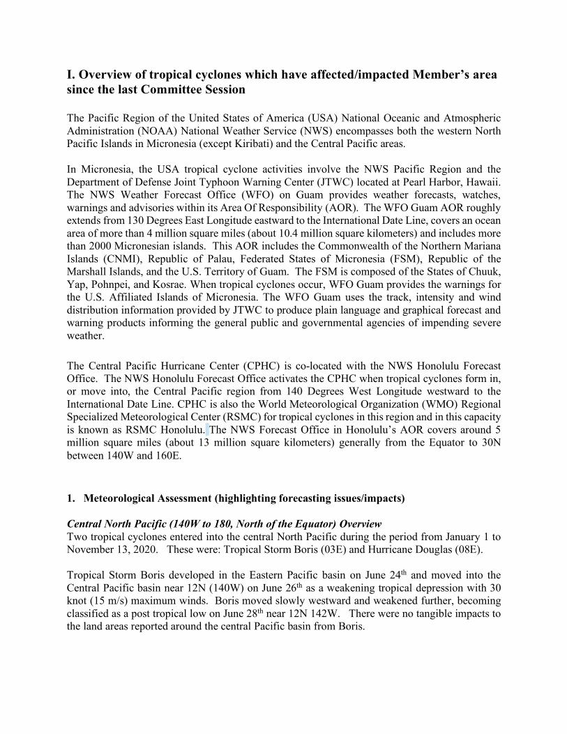
The Central Pacific Hurricane Center (CPHC) is co-located with the NWS Honolulu Forecast Office. The NWS Honolulu Forecast Office activates the CPHC when tropical cyclones form in, or move into, the Central Pacific region from 140 Degrees West Longitude westward to the International Date Line. CPHC is also the World Meteorological Organization (WMO) Regional Specialized Meteorological Center (RSMC) for tropical cyclones in this region and in this capacity is known as RSMC Honolulu. The NWS Forecast Office in Honolulu’s AOR covers around 5 million square miles (about 13 million square kilometers) generally from the Equator to 30N between 140W and 160E. 1. Meteorological Assessment (highlighting forecasting issues/impacts) Central North Pacific (140W to 180, North of the Equator) Overview Two tropical cyclones entered into the central North Pacific during the period from January 1 to November 13, 2020. These were: Tropical Storm Boris (03E) and Hurricane Douglas (08E). Tropical Storm Boris developed in the Eastern Pacific basin on June 24th and moved into the Central Pacific basin near 12N (140W) on June 26th as a weakening tropical depression with 30 knot (15 m/s) maximum winds. Boris moved slowly westward and weakened further, becoming classified as a post tropical low on June 28th near 12N 142W. There were no tangible impacts to the land areas reported around the central Pacific basin from Boris.
Hurricane Douglas was a long track storm which formed on July 20th in the eastern Pacific basin near 115W. Douglas attained hurricane strength winds on July 22nd, then rapidly strengthened to a major hurricane later that day. Hurricane Douglas moved into the central North Pacific basin near 16N (140W) on July 23rd near its peak strength of 115 knots (59 m/s). Douglas moved rapidly off in a west-northwest direction towards the State of Hawaii as the subtropical high pressure ridge weakened across that area. Douglas approached the state of Hawaii from the east as a somewhat weaker hurricane but remained a well-defined hurricane as it passed very close to the north of the island chain on July 26th and 27th. Only after Douglas had moved to the west of the island chain did it rapidly weaken and finally became a post tropical low on July 29th near 25N 175W. Hurricane Douglas brought some significant impacts to some of the islands across the state of Hawaii. These impacts included large and damaging surf to the east facing shores, which resulted in shoreline erosion, property damage and road closures. Heavy rainfall and the strong winds stayed just offshore, with only moderate rainfall and below tropical storm force winds on the land areas.
Figure 1: Tropical Cyclones affecting CPHC AOR in 2020
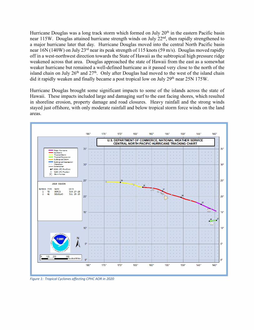
Western North Pacific (130E to 180, north of the equator) Overview A slightly above normal total of twenty-two tropical cyclones (TCs) entered or formed in the WFO Guam AOR from October 15, 2019 to October 31, 2020. This was slightly above last year’s report of nineteen TCs but quite a bit less than the thirty TCs reported in the 2018 season report. Although the total numbers may seem similar to last year, environmental conditions were dramatically different, as described below. Activity in the WFO Guam AOR continued its more normal behavior for the rest of the 2019 TC season from October 15 to December 31, 2019 (Figure 2). In 2019, the year began in a weak El-Nino climate pattern, transitioned into ENSO-neutral conditions by mid-year and ended the year back in weak El-Nino pattern. With these conditions, tracks are generally longer and form farther east in the AOR. This is generally in response to weaker trade winds, a more active monsoon trough stretching farther to the east, more favorable upper-level winds, and perhaps the slightly warmer sea surface temperatures (SSTs) found in the Central Pacific. Tracks were spread out in the AOR. Nine typhoons formed during this period. Three became major typhoons (>99 knots or 51 m/s) of which one, Halong (24W), met the criteria of at least 130 knots (67 m/s) needed for the Joint Typhoon Warning Center (JTWC) to label it a ‘super typhoon’. Of note, two of the nine developed in the central North Pacific and one (Typhoon Matmo, 23W) made the unusual passage across the Southeast Asia and Indochina Peninsula to become a major tropical cyclone in the Bay of Bengal. Four typhoons threatened populated areas and warranted watches and warnings from the WFO Guam: Typhoon Phanfone, (30W) for Yap and the Republic of Palau; Typhoon Kammuri (29W) for Guam, Rota, Tinian and Saipan; Typhoon Bualoi (22W) for Saipan and Tinian and the northern islands of the Commonwealth of the Northern Marianas Islands (CNMI); and, Typhoon Fengshen (26W) for the northern islands of the CNMI. No significant damage or injuries were reported except for some crop damage due to periods of heavy rain.
Figure 2: Tropical cyclones affecting Micronesia (Oct. 15 to Dec 31, 2019)

A look at the tracks for the remaining portion of this report from January 1 to October 31, 2020 shows a dramatic change in TC activity (Figure 3). As the year 2020 moved from a weak El Nino pattern to a moderate La Nina pattern, two significant environmental changes were noted: a) a loss of low-level equatorial westerlies and b) an increase in upper-level westerly shear. Although not an extremely dry year for the AOR, the TC numbers were well below normal for the first part of the year. For the entire western North Pacific basin, the lack of TC development was extreme. For the first time since the JTWC records began in 1945, there were no numbered or named TCs for the month in July. In fact, the warning for the third storm of the year, Hagubit (03W) on August 1, was also the latest on record. Even after August 1, the combination of environmental effects mentioned above, appeared to prevent development of any tropical disturbance that formed in the region to intensify only after the TC was well west or north of Micronesia. In fact, only one tropical storm watch (for Guam with the passage of Tropical Storm Atsani, 23W at the end of October) was issued for the 2020 season through October 31. As evident by the rapid intensification of Super Typhoon Goni (22W) in October, once these disturbances moved into more favorable environmental conditions outside or on the western edge of the AOR, TC activity resumed at a near normal rate, many heading west towards the Philippine Islands or north toward Japan and Korea.
Figure 3: Tropical cyclones affecting Micronesia (Jan 1 to Oct 31, 2020)
2. Hydrological Assessment (highlighting water-related issues/impact) Central North Pacific (140W to 180, North of the Equator) Overview Although Hurricane Douglas made a very close pass to the Hawaiian Islands, the heavy rainfall associated with Douglas remained offshore. Otherwise, widespread heavy rainfall events were not experienced during the 2020 season across the land areas of the central North Pacific. Overall, the region experienced what is characterized as typical La Nina ENSO conditions, persistent dry and stable conditions which were only infrequently featured widely scattered remnant moisture plumes from dissipated tropical cyclones in the eastern Pacific. This led to a severe and worsening drought for many portions of the state of Hawaii and other remote islands in the central North Pacific region during 2020. Western North Pacific (130E to 180, north of the equator) Overview Several tropical systems affected the western North Pacific from October 1, 2019 through the end of November 2019, beginning with Super Typhoon Hagibis (20W), which initially formed October 4, 2019 north-northeast of Pohnpei and moved through the Marianas, producing heavy rainfall that resulted in the issuance of a flash flood warning for Rota, Tinian and Saipan, as well as an urban and small stream flood advisory for Guam. Overall, the Marianas received between 4 and 7 inches (102 – 178 mm) of rain, along with heavy rainfall across the northern islands of the CNMI. Typhoon Bualoi (22W) formed southeast of Majuro in the Marshall Islands. Bualoi moved through the southern Marshall Islands, producing beneficial rains and gusty winds across the southern Marshalls, from Majuro and Mili to Ujae. The storm became a typhoon east of Tinian and Saipan, resulting in moderate to heavy rainfall for Tinian, Saipan and the northern islands of the CNMI. In mid-November, TY Fengshen moved through the northern CNMI, bringing heavy rainfall to Agrihan, Pagan and Alamagan. The most notable storm for rainfall was Typhoon Kammuri (29W). Kammuri formed north of Pohnpei and moved toward the west-northwest, passing north of Fananu in Chuuk State, bringing beneficial rain to northern Chuuk. Kammuri did not make a direct landfall on any of the islands of the western North Pacific Ocean, however, storm total rainfall ranged from near 11 inches (~279 mm) over southern Guam to near 3.5 inches (90 mm) over Saipan. The last storm to affect any of the islands in the western North Pacific region was Typhoon Phanfone (30W). Phanfone formed over southern Chuuk State and moved westward, with slow development until it curved northwest as it moved through south of the island of Woleai. Phanfone intensified to a tropical storm southeast of the island of Ngulu in Yap State, bringing heavy rainfall and tropical storm force winds to the island as it move through just south of Ngulu, then passed through to the north of Kayangel in the Republic of Palau. From late December 2019 through September 30, 2020, the western North Pacific Ocean saw several weak tropical systems, though none of these made any hydrologic impact across the region. The major impact during the calendar year of 2020 resulted from below normal rainfall across many locations in the western North Pacific Ocean. Dry conditions were seen across many locations around mid-March 2020, with the first drought information statement being issued on March 19, 2020. This included moderate to extreme short-term drought for portions of the Republic of the Marshall Islands, moderate to severe short-term drought for portions of the Mariana Islands, Yap State and Chuuk State and moderate short-term drought for portions of Pohnpei State and the Republic of Palau. The drought varied in intensities across the region through the next several months, with several locations reaching severe to exceptional short-term

drought conditions, including Saipan, Tinian and Rota in the Commonwealth of the Northern Mariana Islands (CNMI), Wotje in the Marshall Islands and Kapingamaringi in Pohnpei State. A State of Emergency was declared by the Governor of Chuuk in early April 2020. In all, fourteen drought statements were issued, on average every two weeks, from March 19, 2020 through October 2, 2020. As of October 30, 2020, drought information statements continue to be issued as exceptional drought conditions continue for the island of Kapingamaringi in Pohnpei State. 3.Socio-EconomicAssessment(highlightingsocio-economicandDRRissues/impacts) Central North Pacific (140W to 180, North of the Equator) Overview RSMC Honolulu conducted dozens of tropical cyclone related outreach events, over 100 broadcast and print media interviews, and many formal emergency manager briefings. Due to the ongoing pandemic conditions before and during the season, these outreach events, interviews and briefings were nearly all performed virtually through video teleconferencing. There was one in person support for a press conference at the Hawaii Emergency Operations Center (EOC) as Hurricane Douglas became a major impact threat. During Hurricane Douglas, special consideration, direction and public messaging was given to the unique circumstances associated with discouraging the use of emergency evacuation shelters where large groups of citizens would assemble which would provide an opportunity for increased virus spread. In a collaborative effort between NOAA, RSMC Honolulu, Pacific Disaster Center, and the Department of Emergency Management of Honolulu, storm surge maps were distributed to let the public know who might experience inundation. The maps were GIS files that could be distributed through websites and overlaid by various agencies. Western North Pacific (130E to 180, north of the equator) Overview WFO Guam conducted formal presentations for territorial and military leaders (Governors, Lieutenant Governors, and Commanding Officers), emergency managers, military decision makers and representatives from the Federal Emergency Management Agency (FEMA). The WFO also conducted more than 75 broadcast and print media interviews and participated in more than a dozen outreach events. There were considerably fewer media interviews than in previous years due to the ongoing inactive tropical cyclone pattern in place across the WFO Guam Area of Responsibility. There were fewer outreach events as well due to the ongoing COVID-19 pandemic. Despite this, WFO Guam participated in a number of virtual tours and lectures. WFO Guam continues to develop its communications strategy. The WFO began its Twitter account in the summer of 2020, and plans to join in the NWS experimental phase for the use of Instagram later in 2021. In July, WFO Guam began a partnership with a local news station to do weekly weather outlooks and discussion during their Monday morning news show via Zoom, aired on their web page and their social media pages. Surveys show that these social media posts go beyond the local audience and reach regional and national audiences. Tropical cyclone and natural hazard-related outlooks and briefings included potential impacts to ongoing regional COVID testing and mitigation efforts to help reduce the risk of natural hazards as the region transitioned into the wet season and the busier time of year for tropical cyclones. WFO Guam scaled back its annual two-day Tropical Cyclone, Natural Hazards and Preparedness

workshop to a two-hour virtual seminar provided for both the Territory of Guam and the Commonwealth of the Northern Marianas Islands (CNMI). 4. Regional Cooperation Assessment (highlighting regional cooperation success and challenges. None.
II. Summary of Progress in Priorities supporting Key Result Areas 1. Weather Ready Nation Ambassador Program Main text: Striving for community resilience at a national scale is a major goal for the NOAA National Weather Service. Since embarking on the Weather Ready Nation (WRN) program and expanding it to include the Ambassador Initiative in 2014, NOAA and its partners are moving to make the country weather-resilient. As a WRN Ambassador, partners commit to working with NOAA and other Ambassadors to strengthen national resilience against extreme weather. Throughout 2020, the WRN Ambassador initiative helped and continues to help unify the efforts across government, non-profits, academia, and private industry toward making the nation more ready, responsive, and resilient against extreme environmental hazards. WFO Guam has received numerous positive feedback from territorial and national governments, and military partners, regarding its significant weather alert emails. The WRN through its email alerts has enabled two-way information flow between the WFO and its WRN Ambassadors to share information on preparedness and impacts. This email has become a benchmark product for several Government of Guam agencies in their Tropical Cyclone Standard Operating Procedures. Identified opportunities/challenges, if any, for further development or collaboration: NWS will continue to use the opportunity to engage in multilateral forums and engage with partners in international agreements to help infuse the global weather enterprise with our new weather and climate information, new science, and innovative technology and seek opportunities to learn best practices from other countries to improve our technology and service delivery. We will continue to expand our partnerships to help improve and sustain observing and communications networks essential for early warnings. Priority Areas Addressed: Strengthen typhoon-related disaster risk reduction activities in various sectors, including increased community-based resiliency with better response, communication, and information sharing capability. Contact Information: Member: USA - Guam USA – Hawaii Name of contact for this item: Marcus Aydlett John Bravender Telephone: +1 (671) 472-0946 +1 (808) 973-5275 Email: [email protected] [email protected]

2. Annual Tropical Cyclone Exercises Main text: Annual tropical cyclone exercises are conducted by the Government of Guam, Government of the CNMI, and the State of Hawaii with participation by US National Weather Service Offices at Honolulu and Guam and the US FEMA in order to maintain a level of skill and situational awareness when dealing with tropical cyclones. WFO Guam began collaboration for the regional joint Guam-CNMI Typhoon Pakyo exercise in December 2019. WFO Guam worked closely with the Joint Typhoon Warning Center in Pearl Harbor, Hawaii, to develop typhoon forecast track and intensity graphics to meet the exercise objectives for both Guam and the CNMI. Planning meetings were held in December, February and April to bring the exercise participants together from FEMA, Joint Region Marianas (JRM), Guam and the CNMI. Due to the spread of COVID in the region, the annual typhoon exercise scheduled for June 2020 was canceled. In August, the JRM proceeded with a table-top exercise for the military bases based on the established Typhoon Pakyo plans. RSMC Honolulu participated in multiple state and federal annual tropical cyclone exercises in Hawaii. The NOAA Papahanaumokuakea Marine National Monument Emergency Management Working Group Hurricane Tabletop Exercise in February 2020 was provided simulation graphics and in-person briefings to exercise participants. The annual State of Hawaii Emergency Management’s Makani Pahili 2020 (MP2020) joint agency training exercise was provided sample hurricane track graphics. However, MP2020 was canceled due to the ongoing COVID-related activation. The United States Coast Guard District 14 held a hurricane exercise in June 2020 and RSMC Honolulu provided exercise graphics for their week-long hurricane exercise. Additional realistic hurricane scenario and impact graphics were provided to the state of Hawaii’s Water Agency Response Network for a hurricane recovery tabletop exercise. Identified opportunities/challenges, if any, for further development or collaboration: With staff turnovers affecting every agency, it is important to maintain these exercises such that all persons remain skilled and ready in the event of a real disaster. Due to limitations for in person interactions, exercise participation and support was virtual. Priority Areas Addressed: Enhance capacity to generate and provide accurate, timely and understandable information using multi-hazard impact-based forecasts and risk-based warnings, watches, and advisories. Strengthen typhoon-related disaster risk reduction activities in various sectors, including increased community-based resiliency with better response, communication, and information sharing capability. Contact Information: Member: USA - Guam USA - Hawaii Name of contact for this item: Marcus Aydlett John Bravender Telephone: +1 (671) 472-0946 +1 (808) 973-5275 Email: [email protected] [email protected]

3. Tropical Cyclone Workshops In the western North Pacific, WFO Guam conducts Annual Tropical Cyclone, Disaster Preparedness and Climate Workshop. This workshop is tailored for each island and designed for decision makers in the local, state, and national governments and agencies. The Workshops cover a plethora of topics such as:
• tropical cyclone behavior, structure, and hazards; • the WFO Guam tropical cyclone program, products, and timing of products; • tropical cyclone plotting and speed-distance-time computations; • typhoon risk and vulnerability; a scale that relates tropical cyclone wind speed to
damage and storm surge; • tropical cyclone decision making for individual islands and states; and • WFO Guam website products. • In addition, topics on general climate familiarity, climate variability, and climate
change; El Niño /La Niña and their effects, impacts and status are covered. Other subjects addressed were tsunamis and volcanoes; rip currents, currents, and tides; and earthquakes upon the request of the participants.
In 2020, plans to deliver this workshop to Guam, the CNMI and islands across Micronesia were canceled due to the spread of COVID across the Marianas and strict travel restrictions prohibiting travel to the Republic of the Marshall Islands, the Republic of Palau and the Federated States of Micronesia. By request of the Guam Homeland Security/Office of Civil Defense, WFO Guam delivered a virtual Tropical Cyclone and Natural Hazards Seminar to both Guam and the CNMI. Identified opportunities/challenges, if any, for further development or collaboration: Primary means of educating decision makers of all agencies and ensuring that the information continually updated. Priority Areas Addressed: Enhance capacity to generate and provide accurate, timely and understandable information using multi-hazard impact-based forecasts and risk-based warnings, watches, and advisories. Strengthen typhoon-related disaster risk reduction activities in various sectors, including increased community-based resiliency with better response, communication, and information sharing capability. Contact Information: Member: USA – Guam Name of contact for this item: Marcus Aydlett Telephone: +1 (671) 472-0946 Email: [email protected]

4. StormReady® and TsunamiReady® StormReady® is a program designed by the National Weather Service to help communities and counties implement procedures and supplemental programs to reduce the potential for disastrous, weather-related consequences. StormReady® helps communities evaluate their current levels of preparedness for and response to extreme weather-related events. These communities demonstrate a strong commitment to saving lives and protecting property when hazardous weather strikes. By participating in StormReady®, local agencies can earn recognition for their jurisdiction by meeting guidelines established by the NWS in partnership with federal, state and local emergency management professionals. TsunamiReady® is a similar program that expands preparedness and response of coastal communities to tsunami threats. After the initial recognition, communities can reapply every 3 years. WFO Guam is part of a small team in the NWS tasked with examining external engagements with core partners and decision makers. Revamping and modernizing the StormReady® application and program is one of the group’s focus as it looks at relationships and communications with partners. In March 2020, the Andersen Air Force Base on Guam was recognized for another three years as a StormReady® and TsunamiReady® location. Through these programs, WFO Guam maintains a close working relationship with the emergency managers and air force base leadership for ongoing weather readiness and preparedness. RSMC Honolulu assisted the needs of the 19 StormReady and TsunamiReady communities across the State of Hawaii in 2020. This included ensuring each community had disaster action plans in place and held outreach events to convey a preparedness message. Identified opportunities/challenges, if any, for further development or collaboration: As of November 11, 2020, there were 3,041 StormReady® and/or TsunamiReady® communities in the United States. All of the locations in the Pacific Region, including WFO Guam and RSMC Honolulu AOR are both StormReady® and TsunamiReady®. Priority Areas Addressed: Strengthen typhoon-related disaster risk reduction activities in various sectors, including increased community-based resiliency with better response, communication, and information sharing capability. Contact Information: Member: USA - Guam USA - Hawaii Name of contact for this item: Marcus Aydlett John Bravender Telephone: +1 (671) 472-0946 +1 (808) 973-5275 Email: [email protected] [email protected]

5. Outreach and Education Activities Main text: Numerous outreach and education activities conducted in 2020 include: • Expanded Pacific Hydrology Discussions. Both WFO Guam and RSMC Honolulu provide
input into the Climate Prediction Center’s Monthly ENSO Diagnostics Discussion and employs the use of more comprehensive and targeted products--the Hydrologic Outlook product for extreme rainfall events and the Drought Information Statement for drought events.
• RSMC Press Conference. RSMC Honolulu hosted a press conference with high ranking government officials to announce the 2020 Central Pacific Hurricane Season Outlook on May 20, 2020.
• RSMC Honolulu media interfaces. RSMC Honolulu conducted in the neighborhood of one hundred media interviews, teleconferences and press briefings throughout the season as several of the tropical cyclones had impacts to the Hawaiian Islands in order to provide decision makers with useful and timely information about developing hazards.
• National Disaster Preparedness Month.
September 2020 was declared National Preparedness Month in the USA. On Guam, staff from the WFO Guam conducted a virtual Tropical Cyclone, Natural Hazards and Preparedness seminar to Guam and the CNMI in support of National Preparedness Month. The WFO also hosted a couple of schools virtually to discuss the National Weather Service, forecasts and regional weather patterns.
Identified opportunities/challenges, if any, for further development or collaboration: Outreach events are fundamental in training the general population in disaster preparedness that eventually leads to a more resilient population. Priority Areas Addressed: Strengthen typhoon-related disaster risk reduction activities in various sectors, including increased community-based resiliency with better response, communication, and information sharing capability. Contact Information: Member: USA - Guam USA - Hawaii Name of contact for this item: Marcus Aydlett John Bravender Telephone: +1 (671) 472-0946 +1 (808) 973-5275 Email: [email protected] [email protected]

6. Pacific International Training Desk Main text: The Pacific International Training Desk (PITD), funded by the USA's National Weather Service as part of the US contribution to the WMO Voluntary Cooperation Program (VCP) is now managed by the Telecommunications and Social Informatics (TASI) Research Program at the University of Hawaii. PITD provides one-on-one basic weather forecast training with an emphasis on the tropics. The training program focuses on operational forecasting to enable its participants to prepare and disseminate locally-produced meteorological, hydrologic and climate products for their home countries. There are four components to the training:
1. eLearning Prerequisite Course, a 15-hour course implemented through the use of e-learning modules;
2. On-Site Training Program, a 4-week long, instructor-led on-site training program carried out at the US Weather Forecast Offices across the Pacific; in Honolulu since 2001, Guam since 2016 and American Samoa since 2018;
3. Communications Training, a training on the use of communication systems; and 4. Advanced In-Island workshops on severe weather event topics.
To date, PITD has trained 225 people from all various locations in the Pacific as well as Southeast Asia. PITD will be celebrating 20 years of service in 2021! At the start of 2020, WFO Guam hosted four students undergoing the second phase of their training. However, COVID-19 pandemic led to the cancellation of future residence training. Instead, PITD began a distance-learning cohort in October 2020 with 14 students from seven different countries. PITD has also coordinated webinars this year featuring expert talks from tropical cyclones, mesoscale analysis and climatology in the Pacific. Priority for attendance goes to the Regional Association V (RA V) of the WMO. However, subject to space availability, Typhoon Committee Members may also apply. Identified opportunities/challenges, if any, for further development or collaboration: Regarding the Micronesia Weather Service Offices, all personnel will have completed the training by early 2019. After which the second phase of the PITD in Micronesia will gradually progress into more detailed topics and forecasting techniques for their jurisdictions. Priority Areas Addressed: Enhance capacity to generate and provide accurate, timely and understandable information using multi-hazard impact-based forecasts and risk-based warnings. Enhance Typhoon Committee’s Regional and International collaboration mechanism. Contact Information: Member: USA - Guam USA - Hawaii Name of contact for this item: Genevieve C. Miller Christopher Brenchley Telephone: +1 (671) 472-0944 +1 (808) 973-5273 Email: [email protected] [email protected]

7. Resource Mobilization During Extreme Events Main text: RSMC Honolulu conducted several Emergency Management Briefings during 2020 hurricane season through video teleconferencing. These briefings included personnel at Emergency Operations Centers from the State level to the local level with the State Governor and County Mayors participating at times. WFO Guam provided onsite decision support services deployed to the Guam Homeland Security/Office of Civil Defense Joint Information Center during the passage of Tropical Depression Atsani. These particular heavy weather briefings are primarily catered for the island leadership and military decision makers on potential tropical cyclone threats. Identified opportunities/challenges, if any, for further development or collaboration: Impact-based decision support services are made available to local decision makers especially in locations that lack meteorological support and knowledge. Priority Areas Addressed: Enhance capacity to generate and provide accurate, timely and understandable information using multi-hazard impact-based forecasts and risk-based warnings Strengthen typhoon-related disaster risk reduction activities in various sectors, including increased community-based resiliency with better response, communication, and information sharing capability. Enhance Typhoon Committee’s Regional and International collaboration mechanism. Contact Information: Member: USA - Guam USA - Hawaii Name of contact for this item: Genevieve C. Miller Christopher Brenchley Telephone: +1 (671) 472-0944 +1 (808) 973-5273 Email: [email protected] [email protected]

8. Improved Typhoon-related Disaster Risk Management in Various Sectors Main text: ● Tropical Weather Outlook graphic. During the tropical cyclone season, RSMC Honolulu
prepares and transmits both a text and a graphical Tropical Weather Outlook that illustrates the probability of tropical cyclone development in the next 48 hours and 5 days respectively.
• Time of Arrival graphics. When there is an active tropical cyclone in the AOR, RSMC Honolulu issues graphical products for both “Most Likely Time of Arrival” and “Earliest Reasonable Time of Arrival” to assist government officials and public in their critical decision-making process as they prepare for potential weather impacts.
• Hawaii Emergency Preparedness Executive Consortium (HEPEC). RSMC Honolulu is a member of the Hawaii Emergency Preparedness Executive Consortium (HEPEC). HEPEC is comprised of emergency managers and disaster mitigation personnel from local, state, and federal agencies. HEPEC meets quarterly to provide updates on current and outstanding threats, both natural and manmade, to the State of Hawaii. RSMC Honolulu Personnel provided several hurricane presentations to this group during the Feb 2020 and August 2020 meetings. A hurricane season wrap presentation was expected to be given at the November 2020 meeting.
• Software improvements for Emergency Managers. HURREVAC or HVX (an online
application for emergency managers to gather critical hurricane forecast information) improvements were implemented in 2020, including the information from storm surge modeling in Hawaii.
• IDSS Impact Measurements Initiative Team. The WFO Guam Warning Coordination
Meteorologist serves as the Pacific Region representative on this newly developed team in the National Weather Service. This team is tasked with developing and testing a set of internal and external performance measures to assess NWS Impact-Based Decision Support Services (IDSS). Team goals are to determine the agency’s readiness and capability of delivering IDSS and how is our agency doing at delivering IDSS. The team utilizes two surveys to meet these goals: an event-based survey to be distributed to core partners/agencies immediately following an event requiring decision support services, and an annual review survey, to consider decision support services offered by the WFO throughout the year.
Priority Areas Addressed: Enhance capacity to generate and provide accurate, timely and understandable information using multi-hazard impact-based forecasts and risk-based warnings

Strengthen typhoon-related disaster risk reduction activities in various sectors, including increased community-based resiliency with better response, communication, and information sharing capability. Contact Information: Member: USA - Guam USA – Hawaii Name of contact for this item: Marcus Aydlett John Bravender Telephone: +1 (671) 472-0946 +1 (808) 973-5275 Email: [email protected] [email protected]

9. Technological Improvements
Main text:
● GOES-17 and Himawari Satellite. RSMC Honolulu and WFO Guam have been utilizing the new high-resolution data available from the Japanese Himawari geostationary satellite and mesoscale sector requests in operational forecasting. In addition, data continues to be received, analyzed, and evaluated from the multiple sensors and displays coming from a large number of polar orbiting satellite instruments. One of those sensors is onboard the Suomi NPP satellite and it continues to play a critical role in locating positions of tropical cyclones. The Visible Infrared Imaging Radiometer Suite (VIIRS) is able to produce a day-night band allowing forecasters to receive visible images at night.
● Continued evaluation and application of ocean surface wind vector scatterometer instruments (ASCAT A, B and C, SCATSAT, HY-2B scat and Windsat) and high-resolution SAR data. SCATSAT and HY-2Bscat data plus the three ASCAT instruments and the Windsat sensor are made available in near real-time to the operational forecasters by the European Space Agency (ESA), NOAA/NESDIS and the US Naval Research Laboratory (NRL). Coriolis satellite also provides surface wind data through its Windsat via its 37GHz microwave instrument. During the past two years, newly available high-resolution Synthetic Aperture Radar (SAR) data (C-band) have become available in near real time from the Sentinel-1 satellites. The SAR data plus data from two failed land moisture experiments, SMAP (Soil Moisture Active Passive) and SMOS (Soil Moisture and Ocean Salinity) (both L-band), both of which incredibly have a remaining working sensor that has the ability of measuring winds in excess of 50 m/s (~100 kt) over the ocean surface, are being used to capture the most intense winds near the center of the TC. These winds are normally above the ability of the scatterometer sensors to easily capture and are helping to verify intense TCs that are only previously estimated through the Dvorak intensity technique and where aircraft reconnaissance is not available.
● Contact Information:
Member: USA - Guam USA - Hawaii Name of contact for this item: Roger Edson Robert Ballard Telephone: +1 (671) 472-0948 +1 (808) 973-5274 Email: [email protected] [email protected]


