7055 Samuel Morse Drive, Suite 100, Columbia, Maryland 21446 Tel (443) 741-3500 www.sabra-wang.com Fax (443) 741-3700 MEMORANDUM: BRT Alignments and Stations to Test To: Howard County Office of Transportation, Department of County Administration From: Sabra, Wang & Associates, Inc. Subject: Update to the Howard County Phase II BRT System Alignments, Service Parameters, and Station locations to test (From Task 3 Regional Coordination) Date: September 24, 2015 This memorandum provides an update to the recommended service parameters and BRT alignments and station locations to test provided in an initial memorandum from June, 2015. The Howard County BRT Phase I study (Howard County Countywide Bus Rapid Transit System Travel Forecasting Study; Sabra, Wang and Associates Inc.; 2013), screened and analyzed a number of BRT corridors within and to-from Howard County (US 29, Broken Land Parkway, MD 100, MD 216, and MD 32). It recommended US 29 and Broken Land Parkway as viable corridors that should be targeted for further study and implementation: “The characteristics along US 29 and on Broken Land Parkway would likely support a BRT system that would offer competitive travel options and attract significant ridership”. It also recommended in its next steps that the “possibility of BRT along the US 1 corridor should be explored, given the proximity to rail stations and redevelopment potential.” Another crucial recommendation from the Phase I report enhancing coordination with neighboring jurisdictions (particularly Montgomery County), the State Highway Administration, and the Maryland Transit Administration because any BRT implemented in Howard County is likely to cross boundaries and inter- jurisdictional travel. Consequently, Task 3 of this Phase II study provides for the inter-jurisdictional coordination and identification of the BRT system corridor alignment(s) and the BRT station locations within the US 29, US 1 and Broken Land Parkway corridors to be analyzed in the remainder of the study. The task started with the initial alignments and station locations described in the Scope of Work: US 1: From the College Park Transportation Center (Metro Green Line, MARC Camden Line and future Purple Line) running north along US 1 with stations in south Laurel, downtown Laurel/ Laurel MARC, North Laurel, Savage, Jessup, Dorsey MARC Station, and Elkridge having a terminus of Baltimore/Washington/Thurgood Marshal Airport or Arundel Mills; US 29: From Silver Spring Transit Center running north along US 29 with stations in Four Corners, White Oak, Fairland, Burtonsville, Maple Lawn, Route 32, Town Center, Long Gate, US 40 West and Mount Hebron Broken Land Parkway: From the Columbia Town Center running east along Broken Land Parkway, the CSX rail right-of-way to US 1 and MD 32 with stations at Stevens Forest, Snowden River, Gateway, US 1, and Savage MARC station Figure 1 shows the initial corridor definitions and 5 mile catchment area.
Transcript
7055 Samuel Morse Drive, Suite 100, Columbia, Maryland 21446
Tel (443) 741-3500 www.sabra-wang.com Fax (443) 741-3700
MEMORANDUM: BRT Alignments and Stations to Test
To: Howard County Office of Transportation, Department of County Administration
From: Sabra, Wang & Associates, Inc.
Subject: Update to the Howard County Phase II BRT System Alignments, Service Parameters, and Station locations to test (From Task 3 Regional Coordination)
Date: September 24, 2015
This memorandum provides an update to the recommended service parameters and BRT alignments and station locations to test provided in an initial memorandum from June, 2015.
The Howard County BRT Phase I study (Howard County Countywide Bus Rapid Transit System Travel Forecasting Study; Sabra, Wang and Associates Inc.; 2013), screened and analyzed a number of BRT corridors within and to-from Howard County (US 29, Broken Land Parkway, MD 100, MD 216, and MD 32). It recommended US 29 and Broken Land Parkway as viable corridors that should be targeted for further study and implementation: “The characteristics along US 29 and on Broken Land Parkway would likely support a BRT system that would offer competitive travel options and attract significant ridership”. It also recommended in its next steps that the “possibility of BRT along the US 1 corridor should be explored, given the proximity to rail stations and redevelopment potential.” Another crucial recommendation from the Phase I report enhancing coordination with neighboring jurisdictions (particularly Montgomery County), the State Highway Administration, and the Maryland Transit Administration because any BRT implemented in Howard County is likely to cross boundaries and inter-jurisdictional travel.
Consequently, Task 3 of this Phase II study provides for the inter-jurisdictional coordination and identification of the BRT system corridor alignment(s) and the BRT station locations within the US 29, US 1 and Broken Land Parkway corridors to be analyzed in the remainder of the study. The task started with the initial alignments and station locations described in the Scope of Work:
US 1: From the College Park Transportation Center (Metro Green Line, MARC Camden Line and future Purple Line) running north along US 1 with stations in south Laurel, downtown Laurel/ Laurel MARC, North Laurel, Savage, Jessup, Dorsey MARC Station, and Elkridge having a terminus of Baltimore/Washington/Thurgood Marshal Airport or Arundel Mills;
US 29: From Silver Spring Transit Center running north along US 29 with stations in Four Corners, White Oak, Fairland, Burtonsville, Maple Lawn, Route 32, Town Center, Long Gate, US 40 West and Mount Hebron
Broken Land Parkway: From the Columbia Town Center running east along Broken Land Parkway, the CSX rail right-of-way to US 1 and MD 32 with stations at Stevens Forest, Snowden River, Gateway, US 1, and Savage MARC station
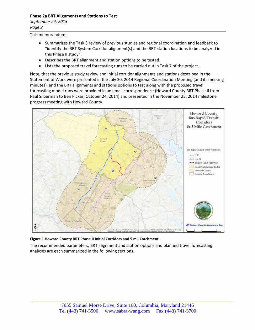
Figure 1 shows the initial corridor definitions and 5 mile catchment area.
Phase 2a BRT Alignments and Stations to Test September 24, 2015 Page 2
7055 Samuel Morse Drive, Suite 100, Columbia, Maryland 21446
Tel (443) 741-3500 www.sabra-wang.com Fax (443) 741-3700
This memorandum:
Summarizes the Task 3 review of previous studies and regional coordination and feedback to “identify the BRT System Corridor alignment(s) and the BRT station locations to be analyzed in this Phase II study”.
Describes the BRT alignment and station options to be tested.
Lists the proposed travel forecasting runs to be carried out in Task 7 of the project.
Note, that the previous study review and initial corridor alignments and stations described in the Statement of Work were presented in the July 30, 2014 Regional Coordination Meeting (and its meeting minutes), and the BRT alignments and stations options to test along with the proposed travel forecasting model runs were provided in an email correspondence (Howard County BRT Phase II from Paul Silberman to Ben Pickar, October 24, 2014) and presented in the November 25, 2014 milestone progress meeting with Howard County.
Figure 1 Howard County BRT Phase II Initial Corridors and 5 mi. Catchment
The recommended parameters, BRT alignment and station options and planned travel forecasting analyses are each summarized in the following sections.
Phase 2a BRT Alignments and Stations to Test September 24, 2015 Page 3
7055 Samuel Morse Drive, Suite 100, Columbia, Maryland 21446
Tel (443) 741-3500 www.sabra-wang.com Fax (443) 741-3700
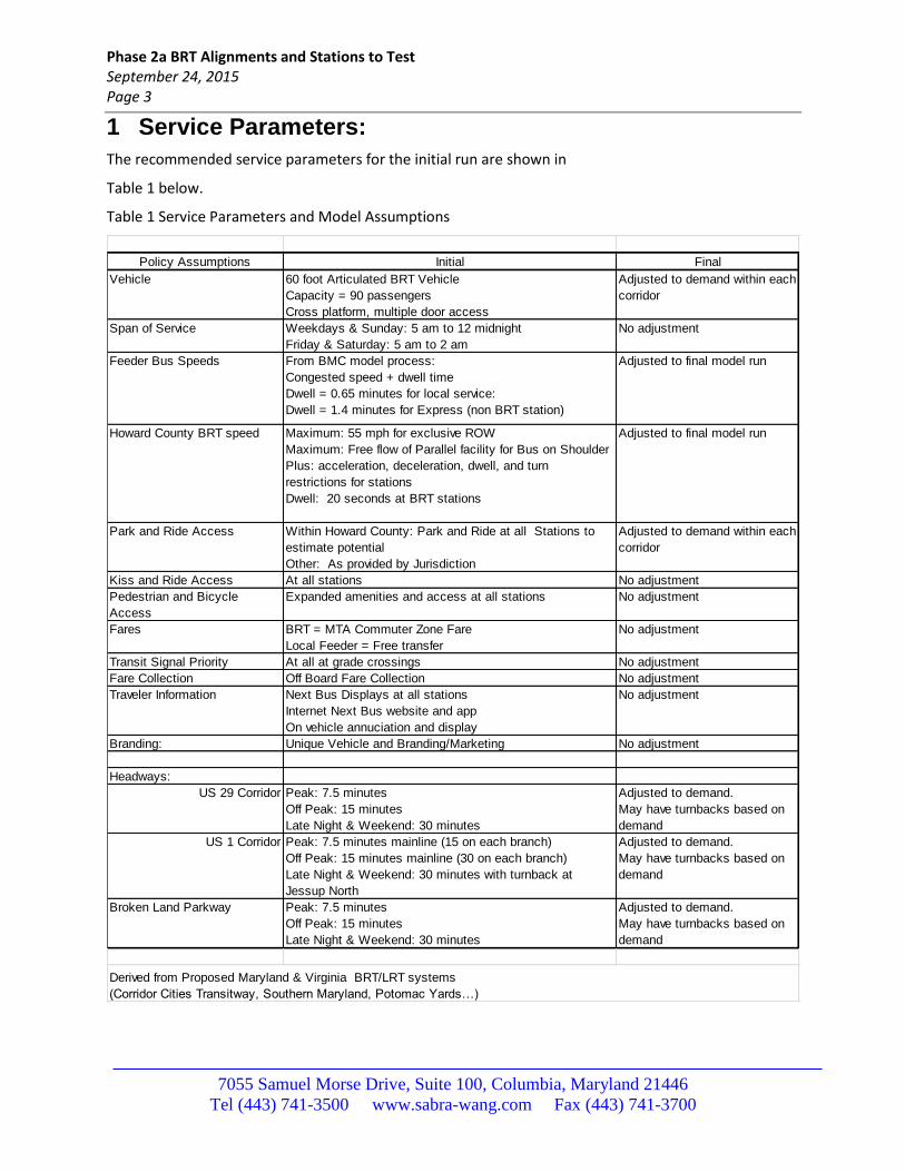
1 Service Parameters:
The recommended service parameters for the initial run are shown in
Table 1 below.
Table 1 Service Parameters and Model Assumptions
Policy Assumptions Initial Final
Vehicle 60 foot Articulated BRT Vehicle
Capacity = 90 passengers
Cross platform, multiple door access
Adjusted to demand within each
corridor
Span of Service Weekdays & Sunday: 5 am to 12 midnight
Friday & Saturday: 5 am to 2 am
No adjustment
Feeder Bus Speeds From BMC model process:
Congested speed + dwell time
Dwell = 0.65 minutes for local service:
Dwell = 1.4 minutes for Express (non BRT station)
Adjusted to final model run
Howard County BRT speed Maximum: 55 mph for exclusive ROW
Maximum: Free flow of Parallel facility for Bus on Shoulder
Plus: acceleration, deceleration, dwell, and turn
restrictions for stations
Dwell: 20 seconds at BRT stations
Adjusted to final model run
Park and Ride Access Within Howard County: Park and Ride at all Stations to
estimate potential
Other: As provided by Jurisdiction
Adjusted to demand within each
corridor
Kiss and Ride Access At all stations No adjustment
Pedestrian and Bicycle
Access
Expanded amenities and access at all stations No adjustment
Fares BRT = MTA Commuter Zone Fare
Local Feeder = Free transfer
No adjustment
Transit Signal Priority At all at grade crossings No adjustment
Fare Collection Off Board Fare Collection No adjustment
Traveler Information Next Bus Displays at all stations
Internet Next Bus website and app
On vehicle annuciation and display
No adjustment
Branding: Unique Vehicle and Branding/Marketing No adjustment
Headways:
US 29 Corridor Peak: 7.5 minutes
Off Peak: 15 minutes
Late Night & Weekend: 30 minutes
Adjusted to demand.
May have turnbacks based on
demand
US 1 Corridor Peak: 7.5 minutes mainline (15 on each branch)
Off Peak: 15 minutes mainline (30 on each branch)
Late Night & Weekend: 30 minutes with turnback at
Jessup North
Adjusted to demand.
May have turnbacks based on
demand
Broken Land Parkway Peak: 7.5 minutes
Off Peak: 15 minutes
Late Night & Weekend: 30 minutes
Adjusted to demand.
May have turnbacks based on
demand
Derived from Proposed Maryland & Virginia BRT/LRT systems
Phase 2a BRT Alignments and Stations to Test September 24, 2015 Page 4
7055 Samuel Morse Drive, Suite 100, Columbia, Maryland 21446
Tel (443) 741-3500 www.sabra-wang.com Fax (443) 741-3700
2 BRT Alignment and Station Options to Test
This section describes the alignments, potential stations, and major configurations that were developed based upon the regional coordination, field visits along the corridor, and feasibility assessments.
A meeting with the Howard County Department of Planning and Zoning, Department of Public Works and Office of Transportation staff took place on August 5, 2015 to integrate comments on the station area planning, route, and more recent feedback on potential option recommendations and developments in neighboring jurisdictions (Montgomery County, Anne Arundel, and Prince George’s). ). Notable highlights include:
The previously identified land for a potential Park and Ride at Mount Hebron and US 29 is no longer available. Initially it was therefore recommended to be dropped from consideration. However, due to the potential linkages to East West travel along I-70 it will now be tested as part of the initial build alternative forecast run.
There are access issues and lack of available land with stations at US 29 and MD 40 and US 29 and MD 32. Both will be dropped from the initial analysis.
It was recommended to start the US 29 BRT ROW at the Long Gate Park and Ride. However, the initial run will now start at Mount Hebron.
Parking at Columbia Town Center was discussed and may have to be at a peripheral lot. If this is the case, the Broken Land Parkway service will extend to peripheral location.
How to serve the Johns Hopkins Applied Physics Laboratory should be explored (feeder service or diversion).
There will be one initial system developed for an initial run. This run will then be refined for a second run.
Given the potential for Transit Oriented Development around the station locations in Howard County an alternative land use scenario may not be warranted.
Rather than a station at US 29 and MD 32, BRT service will start at Broken Land Parkway and the Clarksville Park and Ride Lots and enter the BRT ROW at US 29 and MD 32
Rather than move forward with the two previously defined complete exploration alternatives it was decided to carry out forecasts on an initial recommended BRT system, make refinements based upon its initial results, and prepare final forecasts incorporating the refinements. The initial recommended BRT System based upon the August discussions therefore includes the following:
US 29 Corridor from Mount Hebron to the Silver Spring Transit Center with stations at Mount Hebron, Long Gate, Columbia Town Center, Maple Lawn, Burtonsville, Fairland, US 29 & Tech Road, White Oak Transit Center, Four Corners, and Silver Spring Transit Center. Due to the inability to locate a station and park and ride at US 29 and MD 32, BRT Service will run from the Broken Land Parkway and Clarksville Park and Ride Lots and enter the BRT ROW at MD 32 and US 29.
Broken Land Parkway from a Park and Ride location near Columbia Town Center, through Columbia Town Center, to the Odenton MARC Station with stations at a Columbia Park and Ride, Columbia Town Center, Stevens Forest, Snowden River Parkway, Columbia Gateway, Jessup South, Savage and US 1 Savage MARC, Fort Meade, and Odenton MARC. Shuttle/circulators at Columbia Gateway and Fort Meade will also be assumed. The BRT would run in mixed flow or on the shoulder along MD 32 South of the Savage MARC station.
US 1 from BWI to the College Park Transit Center. Stations include: BWI, BWI Business Park, Northrup Grumman, Consolidated Rental Car facility, Arundel Mills, Dorsey MARC Station,
Phase 2a BRT Alignments and Stations to Test September 24, 2015 Page 5
7055 Samuel Morse Drive, Suite 100, Columbia, Maryland 21446
Tel (443) 741-3500 www.sabra-wang.com Fax (443) 741-3700
Jessup North, Jessup South, Savage, North Laurel, Downtown Laurel, South Laurel, Konterra, College Park North (IKEA), North University of Maryland, University of Maryland US 1 and College Park Transit Center. A branch to the Elkridge station will also be included in the initial runs.
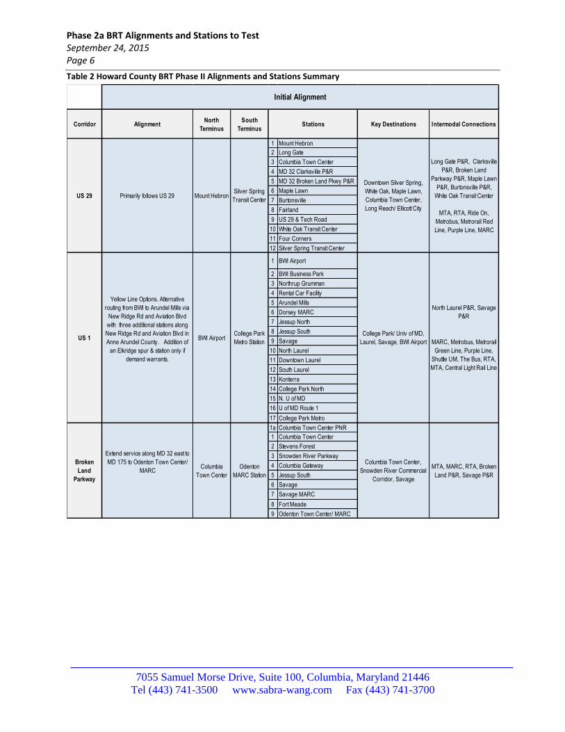
The corridors and their options are summarized in Table 2. An initial travel forecast will be based upon these descriptions. The results of the initial travel forecast will then be used to develop the final recommended options for performance metrics and costing.
One highlight of the feedback is the need to coordinate with the Montgomery County US 29 BRT Study and used the same assumptions for the future land use and development, the underlying road infrastructure, and the BRT characteristics and operations within Montgomery County. The study is therefore coordinating closely with the Montgomery County US 29 BRT study as the future alternatives are further refined.
Each of the corridors and its options are described below.
2.1 US 29 Corridor
The US 29 Corridor extends from Mount Hebron to the North to the Silver Spring Metro Station to the South. The initial option is similar to the recommended service from the Phase I study. Within Howard County an exclusive right of way premium BRT service will be assumed for the BRT analysis with stations at Mount Hebron, Long Gate, Columbia Town Center, and Maple Lawn. Unconstrained parking capacity will be assumed for all of the stations within Howard County in the initial exploratory travel forecasts. Due to access issues and lack of land at MD 32 BRT service will start at the Broken Land and Clarksville Park and Ride Lots, run on the shoulders or in mixed traffic along MD 32 and enter the US 29 BRT at the MD 32 interchange. Figure 2 shows the US 29 Corridor and station locations.
Within Montgomery County the alignment and station locations consistent with the Montgomery County US 29 BRT study and the Montgomery County Transit Functional Master Plan will be assumed. However, as shown in Figure 2 the initial option the Howard County BRT will only make limited stops at the BRT stations serving major activity centers or transfer points. These include Burtonsville, Fairland, US 29 and Tech Road, White Oak Transit Center, Four Corners, and the Silver Spring Transit Center. Within Montgomery County, ROW treatments consistent with the Montgomery County US 29 BRT study will be assumed as they are determined.
Note: Briggs Chaney is not on the BRT right of way and neither option will provide service to/from the Briggs Chaney station due to the additional time it would take to make the diversion.
Phase 2a BRT Alignments and Stations to Test September 24, 2015 Page 6
7055 Samuel Morse Drive, Suite 100, Columbia, Maryland 21446
Tel (443) 741-3500 www.sabra-wang.com Fax (443) 741-3700
Table 2 Howard County BRT Phase II Alignments and Stations Summary
Corridor AlignmentNorth
Terminus
South
TerminusKey Destinations Intermodal Connections
1 Mount Hebron
2 Long Gate
3 Columbia Town Center
4 MD 32 Clarksville P&R
5 MD 32 Broken Land Pkwy P&R
6 Maple Lawn
7 Burtonsville
8 Fairland
9 US 29 & Tech Road
10 White Oak Transit Center
11 Four Corners
12 Silver Spring Transit Center
1 BWI Airport
2 BWI Business Park
3 Northrup Grumman
4 Rental Car Facility
5 Arundel Mills
6 Dorsey MARC
7 Jessup North
8 Jessup South
9 Savage
10 North Laurel
11 Downtown Laurel
12 South Laurel
13 Konterra
14 College Park North
15 N. U of MD
16 U of MD Route 1
17 College Park Metro
1a Columbia Town Center PNR
1 Columbia Town Center
2 Stevens Forest
3 Snowden River Parkway
4 Columbia Gateway
5 Jessup South
6 Savage
7 Savage MARC
8 Fort Meade
9 Odenton Town Center/ MARC
Columbia Town Center,
Snowden River Commercial
Corridor, Savage
MTA, MARC, RTA, Broken
Land P&R, Savage P&R
North Laurel P&R, Savage
P&R
MARC, Metrobus, Metrorail
Green Line, Purple Line,
Shuttle UM, The Bus, RTA,
MTA, Central Light Rail Line
College Park/ Univ of MD,
Laurel, Savage, BWI Airport
Long Gate P&R, Clarksville
P&R, Broken Land
Parkway P&R, Maple Lawn
P&R, Burtonsville P&R,
White Oak Transit Center
MTA, RTA, Ride On,
Metrobus, Metrorail Red
Line, Purple Line, MARC
Initial Alignment
Downtown Silver Spring,
White Oak, Maple Lawn,
Columbia Town Center,
Long Reach/ Ellicott City
Stations
US 29Silver Spring
Transit CenterMount HebronPrimarily follows US 29
Extend service along MD 32 east to
MD 175 to Odenton Town Center/
MARC
Broken
Land
Parkway
Columbia
Town Center
Odenton
MARC Station
US 1
Yellow Line Options. Alternative
routing from BWI to Arundel Mills via
New Ridge Rd and Aviation Blvd
with three additional stations along
New Ridge Rd and Aviation Blvd in
Anne Arundel County. Addition of
an Elkridge spur & station only if
demand warrants.
BWI AirportCollege Park
Metro Station
Phase 2a BRT Alignments and Stations to Test September 24, 2015 Page 7
7055 Samuel Morse Drive, Suite 100, Columbia, Maryland 21446
Tel (443) 741-3500 www.sabra-wang.com Fax (443) 741-3700
Figure 2 US 29 Corridor Potential Alignment and Stations
Phase 2a BRT Alignments and Stations to Test September 24, 2015 Page 8
7055 Samuel Morse Drive, Suite 100, Columbia, Maryland 21446
Tel (443) 741-3500 www.sabra-wang.com Fax (443) 741-3700
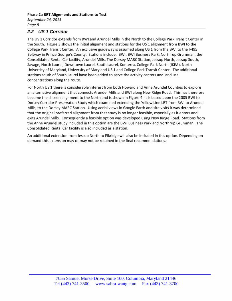
2.2 US 1 Corridor
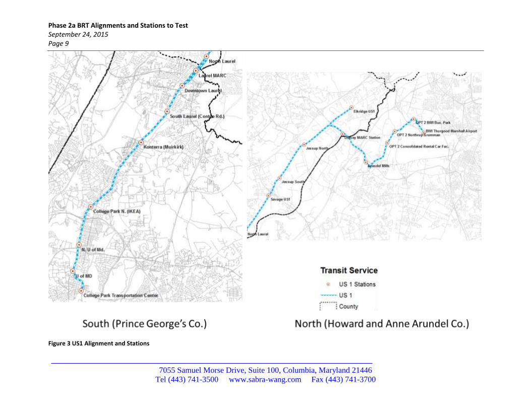
The US 1 Corridor extends from BWI and Arundel Mills in the North to the College Park Transit Center in the South. Figure 3 shows the initial alignment and stations for the US 1 alignment from BWI to the College Park Transit Center. An exclusive guideway is assumed along US 1 from the BWI to the I-495 Beltway in Prince George’s County. Stations include: BWI, BWI Business Park, Northrup Grumman, the Consolidated Rental Car facility, Arundel Mills, The Dorsey MARC Station, Jessup North, Jessup South, Savage, North Laurel, Downtown Laurel, South Laurel, Konterra, College Park North (IKEA), North University of Maryland, University of Maryland US 1 and College Park Transit Center. The additional stations south of South Laurel have been added to serve the activity centers and land use concentrations along the route.
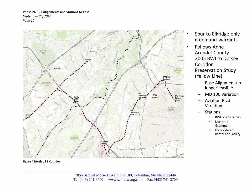
For North US 1 there is considerable interest from both Howard and Anne Arundel Counties to explore an alternative alignment that connects Arundel Mills and BWI along New Ridge Road. This has therefore become the chosen alignment to the North and is shown in Figure 4. It is based upon the 2005 BWI to Dorsey Corridor Preservation Study which examined extending the Yellow Line LRT from BWI to Arundel Mills, to the Dorsey MARC Station. Using aerial views in Google Earth and site visits it was determined that the original preferred alignment from that study is no longer feasible, especially as it enters and exits Arundel Mills. Consequently a feasible option was developed using New Ridge Road. Stations from the Anne Arundel study included in this option are the BWI Business Park and Northrup Grumman. The Consolidated Rental Car facility is also included as a station.
An additional extension from Jessup North to Elkridge will also be included in this option. Depending on demand this extension may or may not be retained in the final recommendations.
Phase 2a BRT Alignments and Stations to Test September 24, 2015 Page 9
7055 Samuel Morse Drive, Suite 100, Columbia, Maryland 21446
Tel (443) 741-3500 www.sabra-wang.com Fax (443) 741-3700
Figure 3 US1 Alignment and Stations
Phase 2a BRT Alignments and Stations to Test September 24, 2015 Page 10
7055 Samuel Morse Drive, Suite 100, Columbia, Maryland 21446
Tel (443) 741-3500 www.sabra-wang.com Fax (443) 741-3700
Figure 4 North US 1 Corridor
Phase 2a BRT Alignments and Stations to Test September 24, 2015 Page 11
7055 Samuel Morse Drive, Suite 100, Columbia, Maryland 21446
Tel (443) 741-3500 www.sabra-wang.com Fax (443) 741-3700
2.3 Broken Land Parkway Corridor
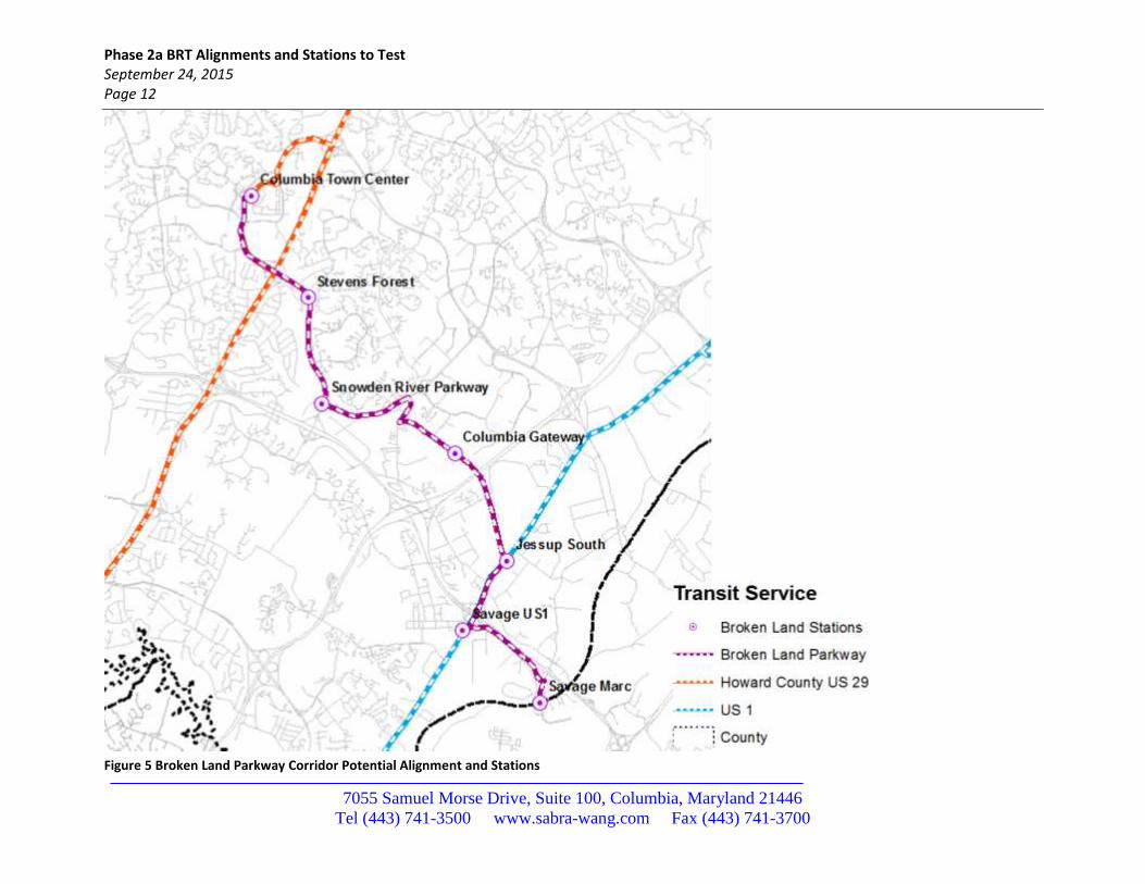
The alignment and stations for the Broken Land Parkway Corridor are shown in Figure 5 and Figure 6. This corridor provides critical connectivity between the US 29 BRT service, and the US 1 Corridor allowing riders from both to reach both BWI, the University of Maryland, and the Silver Spring Transit Center. It runs from the Columbia Town Center to the North to the Savage MARC station to the South, and provides transfers to the US 1 BRT at Jessup South and the US 1 Savage stations. It also would be an exclusive guideway service.
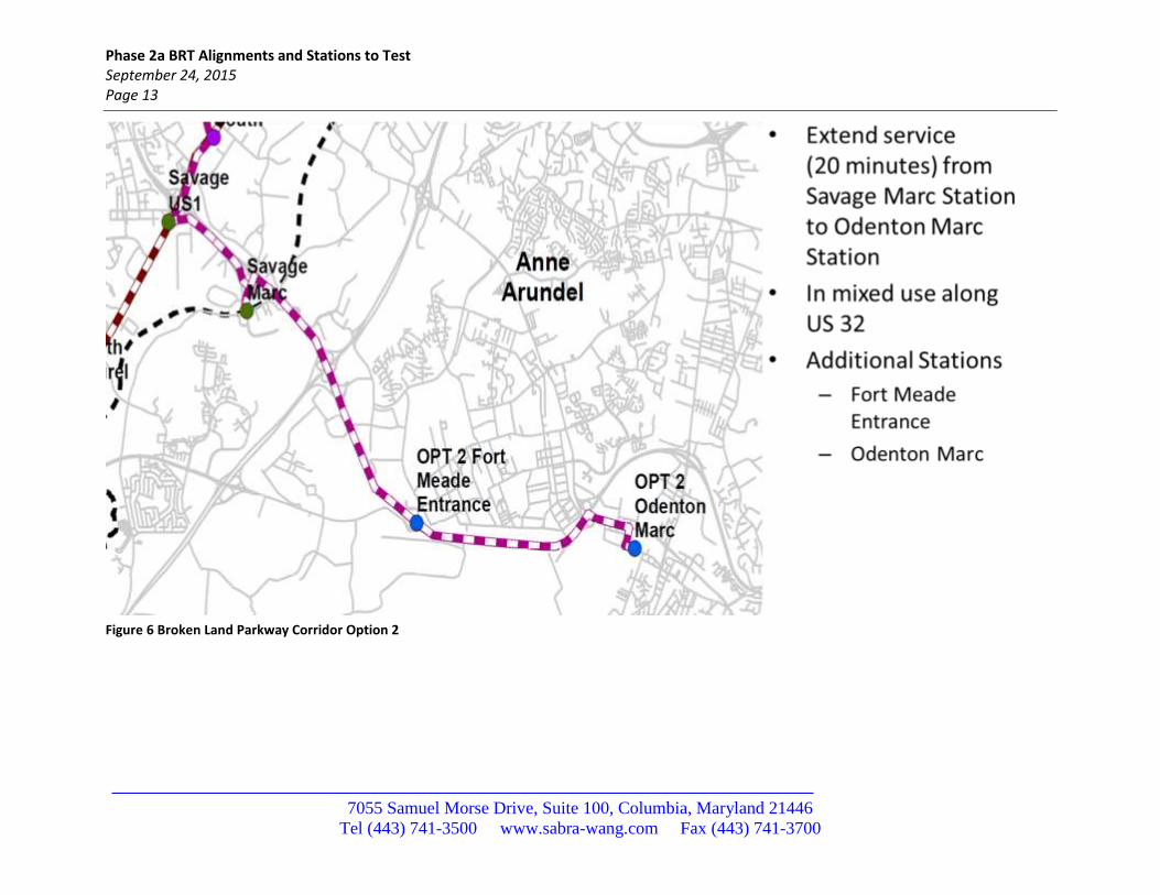
Figure 6 shows the Broken Land Parkway service South of the Savage MARC Station. This is assumed to be in mixed traffic to serve both Fort Meade at its existing gate (with transfers to the Fort Meade shuttles), and then on to the Odenton MARC station. This option has been reviewed for feasibility and may require additional bypass lanes (queue jumpers) or bus on shoulder operations to maintain acceptable travel speeds. Whether these are needed will be part of the analysis of the initial run.
Phase 2a BRT Alignments and Stations to Test September 24, 2015 Page 12
7055 Samuel Morse Drive, Suite 100, Columbia, Maryland 21446
Tel (443) 741-3500 www.sabra-wang.com Fax (443) 741-3700
Figure 5 Broken Land Parkway Corridor Potential Alignment and Stations
Phase 2a BRT Alignments and Stations to Test September 24, 2015 Page 13
7055 Samuel Morse Drive, Suite 100, Columbia, Maryland 21446
Tel (443) 741-3500 www.sabra-wang.com Fax (443) 741-3700
Figure 6 Broken Land Parkway Corridor Option 2
Phase 2a BRT Alignments and Stations to Test September 24, 2015 Page 14
7055 Samuel Morse Drive, Suite 100, Columbia, Maryland 21446
Tel (443) 741-3500 www.sabra-wang.com Fax (443) 741-3700
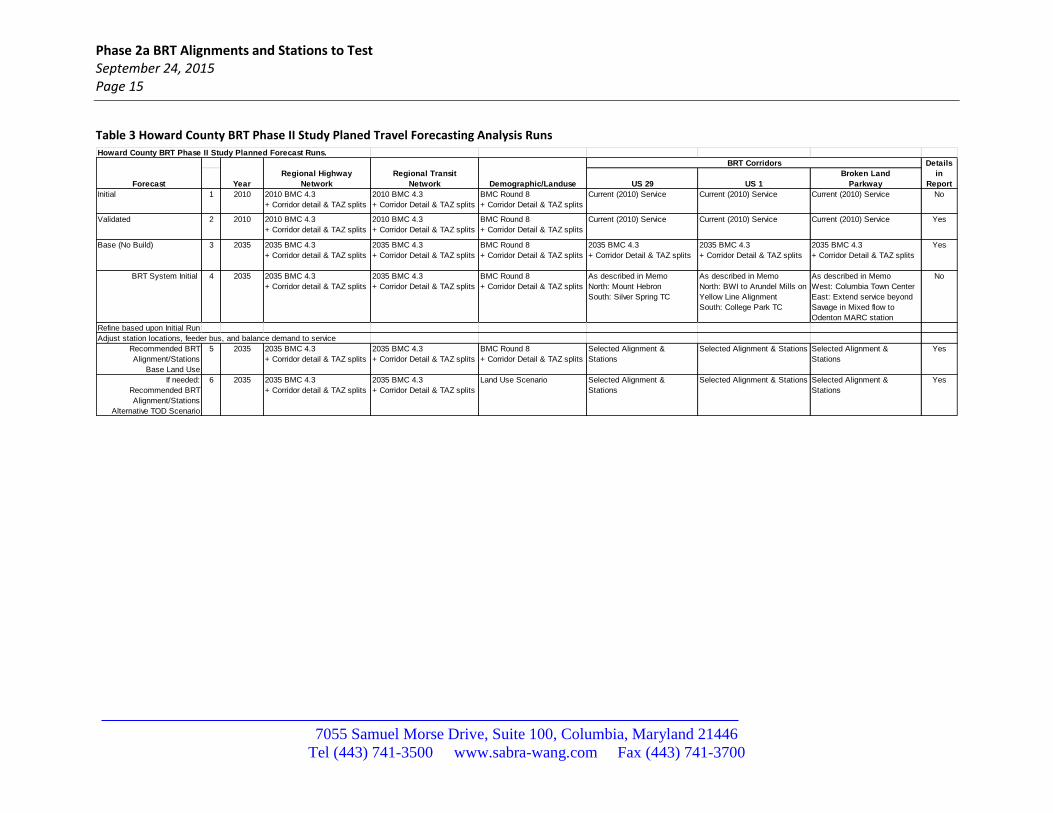
3 Planned Travel Forecasting Analysis Runs
This section provides the proposed travel forecasting analysis runs to examine the alignment options described in Section 3. In addition to the 2010 base year, the original scope of work called for forecasting and analysis of three 2035 BRT System/Landuse Scenarios:
1) Base Case (No Build): a. Currently assumed future land use (BMC Round 8a, Plan Howard 2030 data) (Task 2) b. Base 2035 highway networks (Task 2) c. Base 2035 transit networks and service levels (Task 2)
2) BRT System, Base Land use: a. Currently assumed future land use (BMC Round 8a, Plan Howard 2030 data) (Task 2) b. Base 2035 highway networks (Task 2) c. Three-line Howard County BRT network/service with supporting access (feeder and local
transit, park/kiss-n-ride, pedestrian/bicycle networks (Tasks 3, 4, and 5) 3) BRT System, Base Land use:
a. Alternative TOD future land use and concomitant network changes (Task 6) b. Base 2035 highway networks (Task 2) c. Three-line Howard County BRT network/service with supporting access (feeder and local
transit, park/kiss-n-ride, pedestrian, and bicycle networks (Tasks 3, 4, and 5)
Two full forecasts are assumed for the case 2 forecasts. The outputs of the initial run will be summarized and used to help determine the alignments, station locations, and park and ride recommendations for the final runs and further operations planning (service balancing, parking, bicycle and pedestrian access, etc.) and Task 8 system performance and cost analyses.
Phase 2a BRT Alignments and Stations to Test September 24, 2015 Page 15
7055 Samuel Morse Drive, Suite 100, Columbia, Maryland 21446
Tel (443) 741-3500 www.sabra-wang.com Fax (443) 741-3700
Table 3 Howard County BRT Phase II Study Planed Travel Forecasting Analysis Runs
Howard County BRT Phase II Study Planned Forecast Runs.
US 29 US 1
Broken Land
Parkway
Initial 1 2010 2010 BMC 4.3
+ Corridor detail & TAZ splits
2010 BMC 4.3
+ Corridor Detail & TAZ splits
BMC Round 8
+ Corridor Detail & TAZ splits
Current (2010) Service Current (2010) Service Current (2010) Service No
Validated 2 2010 2010 BMC 4.3
+ Corridor detail & TAZ splits
2010 BMC 4.3
+ Corridor Detail & TAZ splits
BMC Round 8
+ Corridor Detail & TAZ splits
Current (2010) Service Current (2010) Service Current (2010) Service Yes
Base (No Build) 3 2035 2035 BMC 4.3
+ Corridor detail & TAZ splits
2035 BMC 4.3
+ Corridor Detail & TAZ splits
BMC Round 8
+ Corridor Detail & TAZ splits
2035 BMC 4.3
+ Corridor Detail & TAZ splits
2035 BMC 4.3
+ Corridor Detail & TAZ splits
2035 BMC 4.3
+ Corridor Detail & TAZ splits
Yes
BRT System Initial 4 2035 2035 BMC 4.3
+ Corridor detail & TAZ splits
2035 BMC 4.3
+ Corridor Detail & TAZ splits
BMC Round 8
+ Corridor Detail & TAZ splits
As described in Memo
North: Mount Hebron
South: Silver Spring TC
As described in Memo
North: BWI to Arundel Mills on
Yellow Line Alignment
South: College Park TC
As described in Memo
West: Columbia Town Center
East: Extend service beyond
Savage in Mixed flow to
Odenton MARC station
No
Refine based upon Initial Run
Adjust station locations, feeder bus, and balance demand to service