50
Chapter One INVENTORY MESA-FALCON MESA-FALCON FIELD AIRPORT FIELD AIRPORT MESA-FALCON FIELD AIRPORT
Chapter One
INVENTORYMESA-FALCONMESA-FALCONFIELD AIRPORTFIELD AIRPORTMESA-FALCONFIELD AIRPORT
1-1
Chapter One
The inventory of existing conditions at Mesa-Falcon Field Airport (FFZ) will serve as an overview of the airport, its facilities, its role in regional and national aviation systems, and the relationship to development which has occurred around the airport in the past. The information delineated in this chapter provides a foundation, or starting point, for all subsequent evaluations.
The update of this Master Plan required a comprehensive collection and evaluation of information relating to the airport including airport history, physical inventories of facilities and services currently provided by the airport, as well as a review of regional airspace, air traffic control, and aircraft operating procedures.
The information outlined in this chapter was obtained through on-site inspections of the airport, including interviews with airport management, airport tenants, and representatives of various government agencies. Information was also obtained from existing studies, including the City of Mesa Transportation Plan (2003), City of Mesa General Plan (2002), Mesa-Falcon Field Airport Master Plan (1992), and Falcon Field Sub-Area Plan (2007). Additional information and documents were provided by the Federal Aviation Administration (FAA), Maricopa Association of Governments (MAG), Arizona Department of Transportation – Aeronautics Division (ADOT), and the City of Mesa – Development and Sustainability Division.

1-2
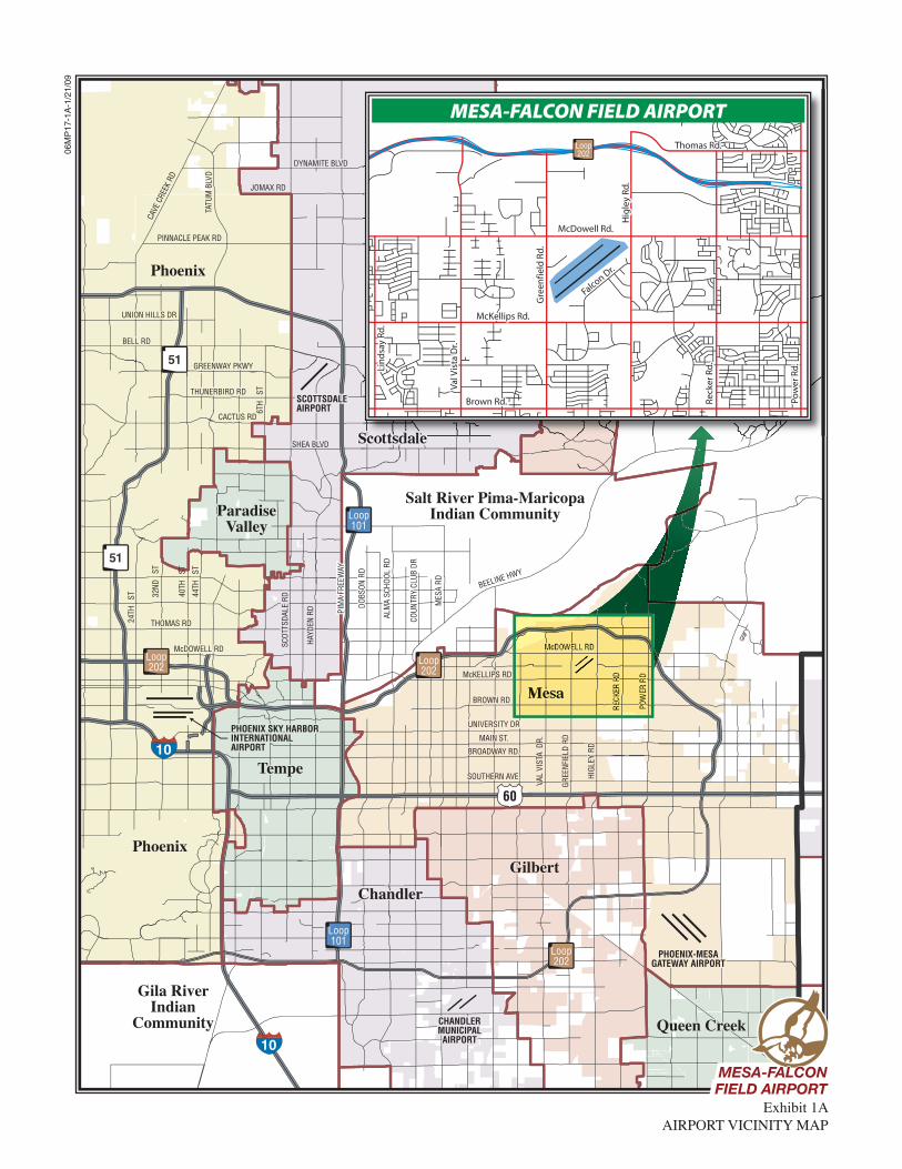
BACKGROUND Any comprehensive master planning effort must factor all influences on an airport. Many of these factors are not directly aviation-related in nature, but do play a key role in the overall growth potential of the airport. Before the airport and its facilities are dis-cussed, these outside influences should be identified. The following sections will discuss the factors which will influence the development poten-tial at Mesa-Falcon Field Airport. AIRPORT LOCATION As depicted on Exhibit 1A, Mesa-Falcon Field Airport sits on approx-imately 784 acres of property on the north side of the City of Mesa, Arizo-na. This includes 575 acres with air-field access and 209 acres to the south and west currently segregated from the airfield by major roadways. The airport is approximately five miles to the northeast of the City of Mesa’s central business district. The City of Mesa is part of the greater Phoenix metropolitan area within Maricopa County. It is located in eastern Mari-copa County, and lies adjacent to Pin-al County just a few miles east. Neighboring communities include Apache Junction to the east, Queen Creek, Gilbert, and Chandler to the south, and Tempe to the west. The Salt River Pima-Maricopa Indian Community lies to the north and con-sists of a less-populated and less-congested land use area. The airport is bounded on the north by East McDowell Road, to the east by North Higley Road, to the south by
East McKellips Road, and to the west by North Greenfield Road. Immediate access to the airport terminal area is provided by Falcon Drive, which is ac-cessed directly from East McKellips Road. Fighter Aces Drive also con-nects to Falcon Drive and provides access to other airport businesses and hangars in the southwest area of the airport. To the east, off of North Hig-ley Road, Falcon Drive provides access to several aviation-related businesses. Eagle Drive provides access to the U.S. Post Office, and Roadrunner Drive provides access to other avia-tion-related businesses. Additional roadways extend off East McDowell Road and North Greenfield Road pro-viding vehicle access to specific areas of the airport. Both east and west bound traffic on East McKellips Road have universal green airport direc-tional signs indicating the main en-trance to the airport. The City of Mesa has excellent access to regional highway infrastructure linking it to the entire Phoenix metro-politan area and points beyond. Loop 202 (Santan Freeway) is a newer roadway system located north of the airport. It creates a bypass around the downtown Mesa area and provides direct access to Tempe and Phoenix to the west and connects to Loop 101 providing service to Scottsdale north and west. Loop 202 also connects to U.S. Highway 60, which leads to Gil-bert and Chandler farther south and west. Known as Superstition Free-way, U.S. Highway 60 runs in an east/west direction on the south side of Mesa and provides access to U.S. In-terstates 10 and 17 farther west. I-10 directly links the Phoenix metropoli-tan area to cities such as Tucson to the
10
10
60
51
51
Loop101
Loop101
Loop202
Loop202
Loop202
FountainHills
Salt River Pima-MaricopaIndian Community
TempeTempeTempe
ChandlerChandlerChandler
Gila RiverIndian
Community Queen CreekQueen CreekQueen Creek
GilbertGilbertGilbert
Phoenix
Phoenix
ParadiseParadiseValleyValley
ParadiseValley
PHOENIX SKY HARBORPHOENIX SKY HARBORINTERNATIONALINTERNATIONALAIRPORTAIRPORT
PHOENIX SKY HARBORINTERNATIONALAIRPORT
SCOTTSDALESCOTTSDALEAIRPORTAIRPORTSCOTTSDALEAIRPORT
CHANDLERCHANDLERMUNICIPALMUNICIPALAIRPORTAIRPORT
CHANDLERMUNICIPALAIRPORT
PHOENIX-MESAPHOENIX-MESAGATEWAY AIRPORTGATEWAY AIRPORT
PHOENIX-MESAGATEWAY AIRPORT
PINNACLE PEAK RD
JOMAX RD
DYNAMITE BLVDDYNAMITE BLVDDYNAMITE BLVD
UNION HILLS DRUNION HILLS DR
BELL RDBELL RD
UNION HILLS DR
BELL RD
GREENWAY PKWYGREENWAY PKWYGREENWAY PKWY
THUNERBIRD RDTHUNERBIRD RD
CACTUS RDCACTUS RD
THUNERBIRD RD
CACTUS RD
SHEA BLVDSHEA BLVDSHEA BLVD
THOMAS RDTHOMAS RDTHOMAS RD
McDOWELL RDMcDOWELL RDMcDOWELL RD
BROWN RD
UNIVERSITY DR
BROWN RD
HIGL
EY R
DHI
GLEY
RD
GREE
NFIE
LD R
DGR
EENF
IELD
RD
VAL
VIST
A D
R.VA
L VI
STA
DR.
HIGL
EY R
D
GREE
NFIE
LD R
D
VAL
VIST
A D
R.
McKELLIPS RDMcKELLIPS RD
UNIVERSITY DR
MAIN ST.MAIN ST.
BROADWAY RD.BROADWAY RD.
MAIN ST.
BROADWAY RD.
SOUTHERN AVE.SOUTHERN AVE.SOUTHERN AVE.
24TH
ST 32
ND
ST
40TH
ST
44TH
ST
6TH
ST
PIM
A FR
EEW
AYPI
MA
FREE
WAY
PIM
A FR
EEW
AY
HAYD
EN R
DHA
YDEN
RD
SCOT
TSDA
LE R
DSC
OTTS
DALE
RD
HAYD
EN R
D
SCOT
TSDA
LE R
D
DOBS
ON R
DDO
BSON
RD
ALM
A SC
HOOL
RD
ALM
A SC
HOOL
RD
MES
A RD
MES
A RD
COUN
TRY
CLUB
DR
COUN
TRY
CLUB
DR
DOBS
ON R
D
ALM
A SC
HOOL
RD
MES
A RD
COUN
TRY
CLUB
DR
BEELINE HWY
TATU
M B
LVD
CAVE
CRE
EK R
D
06M
P17
-1A
-1/2
1/09
FountainHills
Loop202
McDowell Rd.McDowell Rd.
McKellips Rd.McKellips Rd.
Brown Rd.Brown Rd.
Lin
dsa
y Rd
.Li
nd
say
Rd
.
Val V
ista
Dr.
Val V
ista
Dr.
Gre
enfie
ld R
d.
Gre
enfie
ld R
d.
Hig
ley
Rd.
Hig
ley
Rd
.
Reck
er R
d.
Rec
ker R
d.
Pow
er R
d.
Pow
er R
d.
Thomas Rd.Thomas Rd.
McDowell Rd.
McKellips Rd.
Falcon Dr.
Brown Rd.
Lin
dsa
y Rd
.
Val V
ista
Dr.
Gre
enfie
ld R
d.
Hig
ley
Rd.
Reck
er R
d.
Pow
er R
d.
Thomas Rd.
MESA-FALCON FIELD AIRPORT
Exhibit 1AAIRPORT VICINITY MAP
MESA-FALCONMESA-FALCONFIELD AIRPORTFIELD AIRPORTMESA-FALCONFIELD AIRPORT

1-3
southeast and Los Angeles to the west. I-17 provides service to Flagstaff to the north and Beeline Highway pro-vides a northern access route to Pay-son. OTHER TRANSPORTATION MODES Union Pacific rail lines extend through the City of Mesa approximately six miles to the southwest of the airport. Adjacent to the downtown Mesa area, the rail lines make up the Union Pa-cific Business Corridor providing a di-verse employment center with a wide range of retail centers, manufacturing, and technology companies. There are no rail spurs extending in the vicinity of the airport. The City of Mesa has partnered with the cities of Phoenix and Tempe to develop a light rail sys-tem providing service to the region. The system utilizes high-capacity trains with the ability to carry 5,000 passengers each direction per hour during peak periods. The Light Rail Transit (LRT) will initially serve the downtown Mesa area. There are no plans showing the LRT extending into areas near the airport. Greyhound Bus Lines provides a depot in the City of Mesa, approximately eight miles to the southwest on South Country Club Drive. Local transportation includes two ser-vices that serve the general public. The City-funded fixed-route bus ser-vice operates six days a week, for ap-proximately 16 hours per day. There are nine local routes and four express routes to downtown Phoenix. The
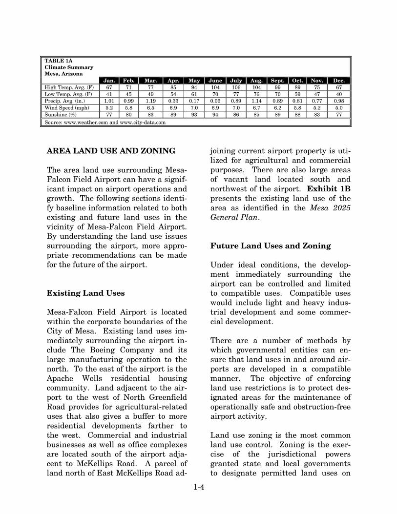
second service is the East Valley Dial-A-Ride, which is a partnership among several public agencies, including the City of Mesa, which provides custom-ers the ability to travel between the cities of Mesa, Chandler, Tempe, Scottsdale, and Gilbert in a more effi-cient manner. Also, proposed to start with the completion of the light rail project in 2008, the Bus Rapid Transit (BRT) system is planned to boost ri-dership of light-rail while taking cars off the road. REGIONAL CLIMATE Weather conditions must be consi-dered in the planning and develop-ment of an airport, as daily operations are affected by local weather. Tem-perature is a significant factor in de-termining runway length needs, while local wind patterns (both direction and speed) can affect the operation and ca-pabilities of the runway. The regional climate is typical of the desert southwest; warm and dry. The normal daily minimum temperature ranges from 40 degrees in December to 77 degrees in July. The normal dai-ly maximum temperature ranges from 67 degrees in December and January to 106 degrees in July. The region av-erages approximately 9 inches of pre-cipitation annually. On average, Mesa experiences sunshine 85 percent of the year. The monthly average wind speed is 6.2 mph, and the predomi-nant wind direction is from the southwest to northeast. A summary of climatic data is presented in Table 1A.
1-4
TABLE 1A Climate Summary Mesa, Arizona Jan. Feb. Mar. Apr. May June July Aug. Sept. Oct. Nov. Dec. High Temp. Avg. (F) 67 71 77 85 94 104 106 104 99 89 75 67 Low Temp. Avg. (F) 41 45 49 54 61 70 77 76 70 59 47 40 Precip. Avg. (in.) 1.01 0.99 1.19 0.33 0.17 0.06 0.89 1.14 0.89 0.81 0.77 0.98 Wind Speed (mph) 5.2 5.8 6.5 6.9 7.0 6.9 7.0 6.7 6.2 5.8 5.2 5.0 Sunshine (%) 77 80 83 89 93 94 86 85 89 88 83 77 Source: www.weather.com and www.city-data.com
AREA LAND USE AND ZONING The area land use surrounding Mesa-Falcon Field Airport can have a signif-icant impact on airport operations and growth. The following sections identi-fy baseline information related to both existing and future land uses in the vicinity of Mesa-Falcon Field Airport. By understanding the land use issues surrounding the airport, more appro-priate recommendations can be made for the future of the airport. Existing Land Uses Mesa-Falcon Field Airport is located within the corporate boundaries of the City of Mesa. Existing land uses im-mediately surrounding the airport in-clude The Boeing Company and its large manufacturing operation to the north. To the east of the airport is the Apache Wells residential housing community. Land adjacent to the air-port to the west of North Greenfield Road provides for agricultural-related uses that also gives a buffer to more residential developments farther to the west. Commercial and industrial businesses as well as office complexes are located south of the airport adja-cent to McKellips Road. A parcel of land north of East McKellips Road ad-
joining current airport property is uti-lized for agricultural and commercial purposes. There are also large areas of vacant land located south and northwest of the airport. Exhibit 1B presents the existing land use of the area as identified in the Mesa 2025 General Plan. Future Land Uses and Zoning Under ideal conditions, the develop-ment immediately surrounding the airport can be controlled and limited to compatible uses. Compatible uses would include light and heavy indus-trial development and some commer-cial development. There are a number of methods by which governmental entities can en-sure that land uses in and around air-ports are developed in a compatible manner. The objective of enforcing land use restrictions is to protect des-ignated areas for the maintenance of operationally safe and obstruction-free airport activity. Land use zoning is the most common land use control. Zoning is the exer-cise of the jurisdictional powers granted state and local governments to designate permitted land uses on
06M
P17
-1B
-1/2
1/09
Exhibit 1BEXISTING LAND USE
Large Lot ResidentialSmall Lot ResidentialMedium Density ResidentialHigh Density Residential
Residential
UndevelopedDedicated / Non-developedRecreational / Open SpaceAgricultureRuralVacant
Regional Retail CenterCommunity Retail CenterNeighborhood Retail Center
Retail
Hotel / Motel / Resort
OfficeBusiness ParkIndustrialAirportPublic FacilityInstitutionalEducational
Employment
Interchange
Future InterchangeFuture Freeway
Arterial Roadway
Aviation Noise Contours
Canals and Waterways
Overhead Transmission Lines
Freeway
Planning Area Boundary
LEGEND
NORTH
Source: City of Mesa 2025 General Plan (2002) MESA-FALCONMESA-FALCON
FIELD AIRPORTFIELD AIRPORTMESA-FALCONFIELD AIRPORT
1-5
each parcel. Typically, zoning is de-veloped through local ordinances and is often included in comprehensive plans. The primary advantage of zon-ing is that it can promote compatibili-ty with the airport while leaving the land in private ownership. Zoning is subject to change; therefore, any po-tential alterations to the zoning code near the airport should be monitored closely for compatibility. Title 11, Chapter 11 of the City of Me-sa Zoning Ordinance establishes the Airfield Overlay District. This district is designed to protect the public health, safety, and general welfare of the area surrounding the airport by minimizing exposure to high noise le-vels and the hazards generated by airport operations. Also, it is to fur-ther the development of compatible land uses around the airport. In addi-tion to the restriction of the Airfield Overlay District, existing zoning sur-rounding the airport calls for light in-dustrial, general industrial, and li-mited commercial except for areas on the east and southeast sides. This zoning is considered compatible with airport activity. The areas on the east and southeast sides of the airport are zoned residen-tial. The largest area is on the east side of North Higley Road, which con-sists of a large area of single resident housing. An area located on the southeast side of the airport, north of East McKellips Road, is also zoned for residential housing in the form of sub-urban ranch. These residential zoning areas are not typically compatible with airport activity. Future airport operations will need to be sensitive to
these existing residential develop-ments. Height restrictions are necessary to ensure that objects will not impair flight safety or decrease the opera-tional capability of the airport. Title 14 of the Code of Federal Regulations (CFR) Part 77, Objects Affecting Na-vigable Airspace, defines a series of imaginary surfaces surrounding air-ports. The imaginary surfaces consist of the approach zone, conical zones, transitional zones, and horizontal zones. Objects such as trees, towers, buildings, or roads, which penetrate any of these surfaces, are considered by the FAA to be an obstruction to air navigation. Current City of Mesa or-dinances adhere to and support the height restriction guidelines as set forth in 14 CFR Part 77. Height re-strictions can be accomplished through height and hazard zoning, avigation easements, or fee simple acquisition. PUBLIC AIRPORT DISCLOSURE MAP Arizona Revised Statutes (ARS) 28-8486, Public Airport Disclosure, pro-vides for a public airport owner to publish a map depicting the “territory in the vicinity of the airport.” The ter-ritory in the vicinity of the airport is defined as the traffic pattern airspace and the property that experiences 60 day-night noise level (DNL) or higher in counties with a population of more than 500,000, and 65 DNL or higher in counties with less than 500,000 res-idents. The DNL is calculated for a 20-year forecast condition. ARS 28-8486 provides for the State Real Es-
1-6
tate Office to prepare a disclosure map in conjunction with the airport owner. The disclosure map is recorded with the county. Mesa-Falcon Field Airport has a traffic pattern map and noise contour map produced in February 1994. It is evident from viewing the maps that they are in need of updat-ing. As part of this Master Plan, an updated Public Airport Disclosure Map has been prepared. AIRPORT HISTORY Construction of the present day Mesa-Falcon Field Airport began during World War II. The British were look-ing for areas to train thousands of pi-lots as World War II was beginning, and Winston Churchill turned to the United States for help in this area. As a result, President Roosevelt called for the establishment of three training bases in the Phoenix area, one of which was Falcon Field, to aid in the training of these British pilots. Con-struction commenced in July of 1941, and by September, the airport was open for training. Initially, the air-port’s only runway was 2,600 feet in length and did not have a paved sur-face. Once the United States became involved in the war, American pilots also utilized the airfield for flight training. Approximately 1,500 pilots trained in the skies over Falcon Field until 1945, when military training ac-tivities ceased due to the end of the war. Once the war was over, there was no longer a need for the airport as a mili-tary installation. As a result, approx-imately 600 acres of land containing
the airport and facilities was turned over to the City of Mesa for one dollar by quitclaim deed in August of 1948. It has remained the City’s since this time. General aviation was not in huge de-mand in the area during the 1950s, and as a result of the airport being underutilized, the City of Mesa leased it to a private company named Rocket Power, Inc. who manufactured solid propellants for military use. In 1965, the City terminated the lease agree-ment and resumed operation of the airfield. It was during this time that the initial runway was lengthened to 4,300 feet and widened to 100 feet. The airport was officially annexed into the city boundary in 1978. During the 1980s, there were several improve-ments and activities occurring at the airport, including construction of the present-day parallel runway and addi-tional taxiways, the extension of the main runway to its present length of 5,100 feet, upgrades to approach light-ing and navigational aids, and the first AH-64 Apache Attack Helicopter rolling out of the Hughes Helicopter factory, known today as The Boeing Company. In 1992, the previous Air-port Master Plan was completed. Since this time, numerous utility and environmental improvements have been made in addition to other rec-ommendations called for in the plan. Today, Mesa-Falcon Field Airport is ranked among the nation’s “top 10” general aviation airports in terms of based aircraft and number of flight operations. Several aviation-related businesses are located on the field that
1-7
provide an array of general aviation services. RECENT CAPITAL IMPROVEMENTS Table 1B summarizes a list of the ma-jor improvements made to Mesa-Falcon Field Airport since 1998. Since
this time, approximately $17 million has been invested in the airport. The vast majority of this total has been funded through various federal and state grants. This has included fund-ing for engineering and construction projects, planning studies, airfield safety improvements, and security en-hancements.
TABLE 1B Projects and Improvements Since 1998 Mesa-Falcon Field Airport
Grant Number
Description
Total Grant Amount
FEDERAL GRANTS 304-0023-06 Construct new taxiway and apron; reconstruct existing taxiways and taxilanes $942,157 304-0023-07 Taxiway improvements $1,027,000 304-0023-08 Drainage improvements adjacent to taxiway $1,000,000 FAA-09 Airfield signage improvements; electrical upgrades; parallel taxiway and apron
improvements $1,035,109
FAA-10 Land acquisition $500,830 FAA-11 Pavement preservation improvements; pavement marking upgrades; road
study $150,000
FAA-12 Construct hangar area; Falcon Drive cul-de-sac design and construction $2,503,423 FAA-13 Pavement preservation improvements; taxiway improvements $365,000 FAA-14 Runway safety area improvements; perimeter fencing installation $1,139,396 FAA-15 Airport Master Plan Update $170,000 Subtotal Federal Grants $8,832,915 STATE GRANTS ADOT E9081 Terminal building design $125,000 ADOT E9023 Construct new taxiway and perimeter road; security enhancements $969,750 ADOT N607 Drainage and pavement preservation designs $500,000 ADOT N709 Construct new taxiway and perimeter road; security enhancements $650,000 ADOT N819 Taxiway improvements $46,250 ADOT N867 Taxiway and taxilane improvements; taxiway design; hangar rehabilitation;
runway safety area improvements $437,500
ADOT E0128 Airport layout plan update $9,000 ADOT E0116 Construct new terminal building $774,000 ADOT E0105 Taxiway improvements $225,000 ADOT E0157 Taxiway improvements $50,414 ADOT E1133 Drainage improvements adjacent to taxiway $49,089 ADOT E1113 Design perimeter road, fencing, and drainage; install fencing $171,000 ADOT E0165 Apron design; electrical upgrades $119,000 ADOT E9081 Terminal design $125,000 ADOT E1145 Airfield signage improvements; electrical upgrades; parallel taxiway and apron $50,812 ADOT E2F43 Land acquisition $24,585 ADOT E2S11 Taxiway and apron improvements $600,000 ADOT E3S02 Design and install perimeter fencing $270,000 ADOT E3S03 Pavement marking improvements $90,000 ADOT E3S04 Taxiway reconstruction $180,000

1-8
TABLE 1B (Continued) Projects and Improvements Since 1998 Mesa-Falcon Field Airport
Grant Number
Description
Total Grant Amount
STATE GRANTS (Continued) ADOT E3F48 Pavement preservation improvements; pavement marking upgrades; road
study $7,363
ADOT E3F49 Construct hangar area; Falcon Drive cul-de-sac design and construction $122,889 ADOT E4F49 Pavement preservation improvements; taxiway improvements $17,917 ADOT E6S22 Apron design and construction $594,000 JPA 05-02 Pavement preservation $1,175,000 ADOT E7S26 Design and construct eastside aeronautical use area $270,000 ADOT EFS29 Security fencing installation $225,000 ADOT E7F52 Airport Master Plan Update $58,178 ADOT E7F59 Airport Master Plan Update $4,250 ADOT E7F60 Runway safety area improvements; perimeter fencing installation $29,985 Subtotal State Grants $7,970,982 TOTAL ALL GRANTS $16,803,897 Source: Airport records
FUEL SALES Falcon Executive Aviation and Tango One Aviation are the fixed base opera-tors (FBOs) on the airfield that pro-vide fueling services. Overall, fuel sales have increased steadily over the years with the exception of 2006. Prior to 2007, noticeable trends were evident in the amount of Avgas versus the amount of Jet A fuel disbursed.
Avgas fuel totals had declined since 2002, while Jet A fuel totals had sig-nificantly increased during the same time period. The significant increase in Avgas fuel sales in 2007 is most likely attributed to the increase in flight training activity at the airport. Table 1C summarizes combined fuel sales by both FBO operators at the airport.
TABLE 1C Historical Fuel Sales Mesa-Falcon Field Airport
Year Avgas (gallons) Jet A (gallons) Totals 2002 2003 2004 2005 2006 2007
604,961 599,604 581,962 528,877 502,922 716,653
378,963 402,267 497,305 702,929 648,764 628,345
983,924 1,001,871 1,079,267 1,231,806 1,151,686 1,344,998
Source: Airport records
1-9
AIRPORT ADMINISTRATION Mesa-Falcon Field Airport is owned and operated by the City of Mesa. The City of Mesa employs a full-time Air-port Director who reports to one of three Deputy City Managers within the City’s administrative structure. The airport also employs a full-time Airport Projects Supervisor and Air-port Administrative Supervisor who report directly to the Airport Director. In addition, there are seven full-time employees who serve in administra-tive, operational, and maintenance ca-pacities. The airport staff maintains a presence on the airport seven days per week. The airport is an independent business department within the City and operates as an enterprise fund, meaning it is financially self-sufficient and does not require contributions from the City of Mesa’s general fund. ECONOMIC IMPACTS The last formal economic impact study of the airport was completed by ADOT in 2002. This study analyzed the di-rect, indirect, and induced economic impact of all public use airports in Arizona, including Mesa-Falcon Field Airport. At the time, it was estimated that Mesa-Falcon Field Airport had an impact of $2.71 billion annually on the local economy. The total economic impact of the air-port includes the direct-effect em-ployment, payroll, and sales. Indirect benefits would include visitor spend-ing, which leads directly to off-airport employment, payroll, and sales. The cumulative economic benefit of an air-port includes a multiplier effect which
is essentially the recycling of money within the local economy to create more jobs in nearly every economic sector. On-airport direct economic benefits include 5,312 jobs, with a direct pay-roll of $320.3 million and sales of over $1 billion. Visitor spending accounts for 456 additional jobs, $9.1 million in payroll, and $22.3 million in sales. When the multiplier effect is applied, economic activity generated at Mesa-Falcon Field Airport accounts for 17,602 local jobs, $701 million in pay-roll, and $2 billion in sales. These fig-ures are very impressive as most re-liever airports such as Mesa-Falcon Field typically generate less than $50 million in total impacts and fewer than 500 jobs. STORM WATER POLLUTION PREVENTION PLAN (SWPPP) Stormwater runoff is simply rainwater or snowmelt that runs off the land and into streams, rivers, and lakes. When stormwater runs through sites of in-dustrial or construction activity it may pick up pollutants and transport them into national waterways and affect water quality. Mandated by Congress under the Clean Water Act, the National Pollu-tant Discharge Elimination System (NPDES) Stormwater Program is a comprehensive two-phased national program for addressing the non-agricultural sources of stormwater discharges which adversely affect the quality of our nation’s waters. The program uses the NPDES permitting

1-10
mechanism to require the implemen-tation of controls designed to prevent harmful pollutants from being washed by stormwater runoff into local water bodies. The State of Arizona has been dele-gated the authority to administer the NPDES program. Administratively, this is the responsibility of the Arizona Department of Environmental Quality (ADEQ). The ADEQ’s Arizona Pollu-tant Discharge Elimination System (AZDES) program now has regulatory authority over discharges of pollutants to Arizona surface water. Under the regulations, separate per-mits are required for construction ac-tivities that disturb one or more acres of land and for general stormwater permits. Airports are included as an industrial facility under the AZDES and must obtain a Multi-Sector Gen-eral Permit. This permit requires the development of a SWPPP. The airport has a SWPPP in place which is updated annually. The SWPPP for the airport includes air-port tenants, and the City of Mesa provides annual training and inspec-tion services. The airport has a Multi-Sector General Permit. SPILL PREVENTION CONTROL AND COUNTERMEASURES (SPCC) PLAN Title 40 of the Code of Federal Regula-tions (CFR) Part 112, defines the En-vironmental Protection Agency’s (EPA) Oil Pollution Prevention Plan. The purpose of the rule is to prevent
the discharge of oil into the navigable waters of the United States or adjoin-ing shorelines as opposed to response and cleanup after a spill occurs. The EPA revised these prevention rules on July 17, 2002, to establish the SPCC Plan to meet the purpose of this rule. The EPA has recently approved a final rule to extend compliance dates for SPCC Plans to July 1, 2009. Before a facility is subject to the SPCC rule, it must meet the following three criterion: 1) it must be non-transportation re-
lated, 2) it must have an aggregate above-
ground storage capacity greater than 1,320 gallons or a completely buried storage capacity greater than 42,000 gallons, and
3) there must be a reasonable expecta-
tion of a discharge into or upon na-vigable waters of the United States or adjoining shorelines.
By definition within the rule, an air-port is considered a non-transportation-related facility. In us-ing this wording, the EPA is trying to distinguish between oil delivery ve-hicles using public roadways from those facilities that store or handle oil products. The airport has 10,000 gal-lons of above-ground fuel storage and 66,000 gallons of below-ground fuel storage, exceeding the minimums for above and below-ground storage ca-pacities. Finally, there are a number of existing washes and ditches on the airport that lead to navigable waters of the United States. Therefore, the airport meets all three criterion.
1-11
The airport currently does not have a SPCC Plan in place to address issues related to the discharge of oils. As stated earlier, the SPCC has extended the compliance deadline to July 1, 2009 for owners and operators of facil-ities to prepare or amend and imple-ment their SPCC Plan. AIRPORT SYSTEM PLANNING ROLE Airport planning exists on four prima-ry levels: local, regional, state, and na-tional. Each level has a different em-phasis and purpose. An Airport Mas-ter Plan is the primary local airport planning document. This Master Plan will provide a vision of both the airside and landside facilities over the course of the next 20 years. At the regional level, Mesa-Falcon Field Airport is included in the MAG Regional Aviation System Plan (RASP). The RASP is in place to pro-vide an overview for airport planning in the region, to set the overall plan for airports in the region, and to as-sess proposed project costs and the proper phasing of projects. Mesa-Falcon Field Airport is one of 16 air-ports included in the RASP which MAG considers important to meeting the region’s demand for aviation ser-vices. At the state level, Mesa-Falcon Field Airport is included in the Arizona State Aviation System Plan (SASP). The purpose of the SASP is to ensure that the state has an adequate and ef-ficient system of airports to serve its aviation needs. The SASP defines the
specific role of each airport in the state’s aviation system and establishes funding needs. Through the state’s continuous aviation system planning process, the SASP is updated approx-imately every five years. According to records, the most recent update to the SASP was in 2000 when the State Aviation Needs Study (SANS) was prepared. The SANS provides policy guidelines that promote and maintain a safe aviation system in the state, as-sess the state’s airports’ capital im-provement needs, and identify re-sources and strategies to implement the plan. Mesa-Falcon Field Airport is one of 112 airports included in the 2000 SANS, which includes all public and private airports and heliports in Arizona that are open to the public, including American Indian and recre-ational airports. At the national level, the airport is in-cluded in the FAA National Plan of Integrated Airport Systems (NPIAS). This plan includes a total of 3,431 ex-isting airports that are significant to national air transportation and are therefore eligible to receive grants un-der the FAA Airport Improvement Program (AIP). The NPIAS supports the FAA’s strategic goals for safety, system efficiency, and environmental compatibility by identifying specific airport improvements. An airport must be included in the NPIAS to be eligible for federal grant-in-aid assis-tance from the FAA. The 2007-2011 NPIAS identifies $41.2 billion for airport development across the country. Of that total, approx-imately seven percent is designated for the 274 reliever airports identified.
1-12
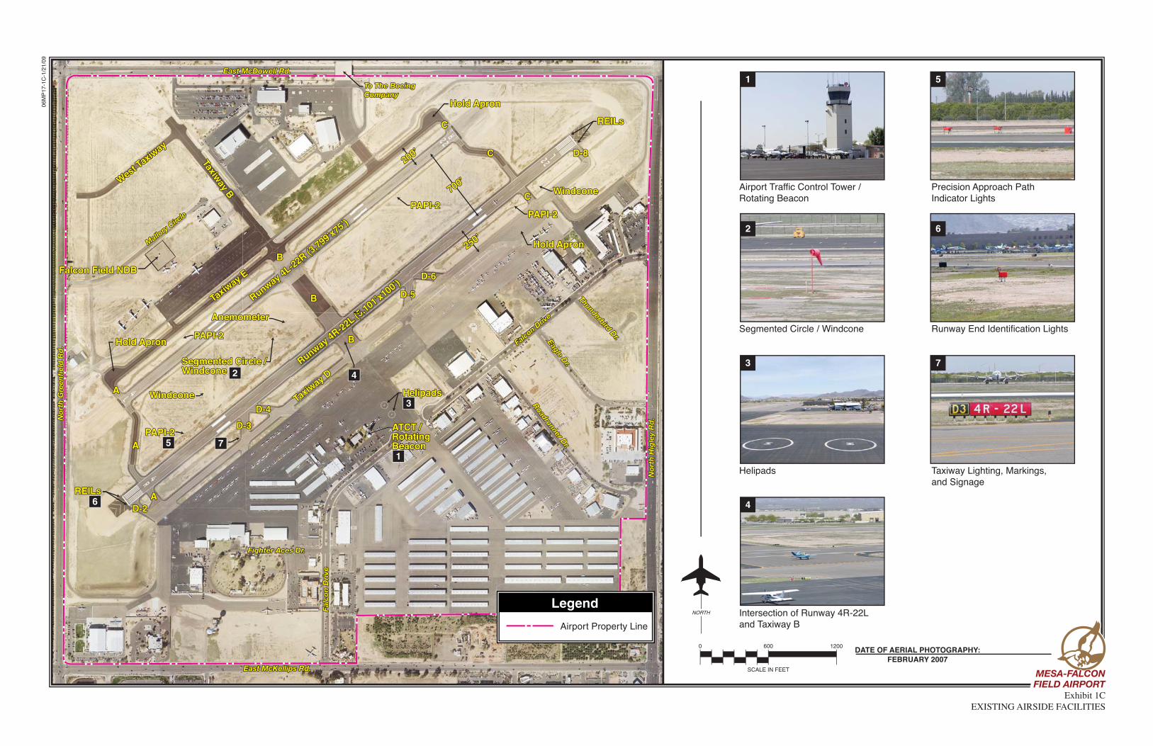
Reliever airports are located in major metropolitan areas and serve to pro-vide pilots with an attractive alterna-tive to using busy commercial service airports. Moreover, these airports provide a vital function of relieving congestion at capacity-constrained airports. Mesa-Falcon Field Airport is one of seven designated reliever air-ports in the Phoenix metropolitan area for Phoenix Sky Harbor International Airport. According to the NPIAS, re-liever airports across the country have an average of 232 based aircraft and account for 29 percent of the nation’s total active aircraft fleet. AIRPORT FACILITIES Airport facilities can be functionally classified into two broad categories: airside and landside. The airside cat-egory includes those facilities which are needed for the safe and efficient movement of aircraft, such as run-ways, taxiways, lighting, and naviga-tional aids. The landside category in-cludes those facilities necessary to provide a safe transition from surface to air transportation and support air-craft servicing, storage, maintenance, and operational safety on the ground. AIRSIDE FACILITIES Existing airside facilities are identi-fied on Exhibit 1C. Table 1D sum-marizes airside facility data for Mesa-Falcon Field Airport.
Runways Mesa-Falcon Field Airport is served by parallel runways orientated in a northeast/southwest manner. Runway 4R-22L and Runway 4L-22R are sepa-rated by 700 feet from centerline to centerline, which is the minimum se-paration allowed for a parallel runway system. Runway 4R-22L is 5,101 feet long by 100 feet wide. The asphalt runway is in “good” condition, the highest rating the FAA designates for runway condi-tion. The pavement has been strength rated at 38,000 pounds single wheel loading (SWL), 60,000 pounds dual wheel loading (DWL), and 90,000 pounds dual tandem wheel loading (DTWL). SWL refers to the design of aircraft landing gear which has one wheel on each landing gear strut. DWL and DTWL include the design of aircraft landing gear with additional wheels on each landing gear strut which distributes more of the aircraft weight on the runway and taxiway surfaces; thus, the surface itself can support a greater total aircraft weight. The weight-bearing strengths listed above are adequate to accommodate nearly all aircraft in the general avia-tion fleet today. Runway 4L-22R is 3,799 feet long by 75 feet wide. The asphalt runway is in “good” condition and provides a weight-bearing capacity of 12,500 pounds SWL.
06M
P17
-1C
-1/2
1/09
Exhibit 1CEXISTING AIRSIDE FACILITIES
SCALE IN FEET
DATE OF AERIAL PHOTOGRAPHY:FEBRUARY 2007
0 600 1200
NORTH
Runway 4R-22L (5,101’x100’)
(5(5
Runway 4L-22R (3,799’x75’)
Runway 4L-22R (3,799’x75’)
REILsREILs
PAPI-2PAPI-2
PAPI-2PAPI-2
AA
AA
AA
D-3D-3
D-2D-2
D-4D-4
D-5D-5
D-6D-6
D-8D-8
CC
CC
CC
Falcon Field NDBFalcon Field NDB
BB
BB
BB
Taxiway D
Taxiway D
Taxiway E
Taxiway E
Taxiway B
Taxiway B
West Taxiw
ay
West Taxiw
ay
Falc
on D
rive
Falc
on D
rive
Falcon Driv
e
Falcon Driv
e
East McKellips Rd.East McKellips Rd.
Nor
th G
reen
fiel
d R
d.
Nor
th G
reen
fiel
d R
d.
Fighter Aces Dr.Fighter Aces Dr.
ATCT /RotatingBeacon
ATCT /RotatingBeacon
HelipadsHelipads
Hold ApronHold Apron
WindconeWindcone
REILsREILs
Nor
th H
igle
y R
d.
Nor
th H
igle
y R
d.
Roadrunner Dr.
Roadrunner Dr.
Eagle Dr.
Eagle Dr.
Thunderbird Dr.
Thunderbird Dr.
Hold ApronHold Apron
East McDowell Rd.East McDowell Rd.
To The BoeingCompanyTo The BoeingCompany
Hold ApronHold Apron
Mallory
Circle
Mallory
Circle PAPI-2PAPI-2
PAPI-2PAPI-2
WindconeWindcone
Segmented Circle /WindconeSegmented Circle /Windcone
AnemometerAnemometer
250’250’
200’200’
700’700’
Airport Traffic Control Tower /Rotating Beacon
Segmented Circle / Windcone
Helipads
Intersection of Runway 4R-22Land Taxiway B
Precision Approach PathIndicator Lights
Runway End Identification Lights
Taxiway Lighting, Markings,and Signage
1
2
3
4
7
6
5
1
4
3
2
5
6
7
Legend
Airport Property Line
MESA-FALCONMESA-FALCONFIELD AIRPORTFIELD AIRPORTMESA-FALCONFIELD AIRPORT
1-13
Helipads There are two designated helipads lo-cated on the terminal ramp apron di-rectly northeast of the airport traffic control tower (ATCT). The helipads
are dimensioned 60 feet long by 60 feet wide and are constructed of as-phalt. They provide a weight-bearing capacity of 30,000 SWL and are rated in “good” condition by the FAA.
TABLE 1D Airside Facility Data Mesa-Falcon Field Airport Runway 4R-22L Runway 4L-22R Two Helipads Length (feet) Width (feet) Surface Surface Treatment Condition Runway Load Bearing Strength (pounds):
Single Wheel Loading (SWL) Dual Wheel Loading (DWL) Dual Tandem Wheel Loading (DTWL)
Runway Lighting Runway Markings
5,101 100
Asphalt None Good
38,000 60,000 90,000 MIRL
Non-precision
3,799 75
Asphalt None Good
12,500
N/A N/A
MIRL Basic
60 60
Asphalt None Good
30,000
N/A N/A N/A N/A
Taxiway Lighting Taxiway Marking
MITL Centerline striping
MITL Centerline striping
N/A N/A
Visual Approach Aids: Approach Slope Indicators Approach Lighting
PAPI - 2 REILs
PAPI-2
N/A
N/A N/A
Instrument Approach Aids
GPS Runway 4R NDB/GPS-A
N/A
N/A
Weather or Navigational Aids LAWRS; NDB on field; Anemometer; ATCT Visual Aids Segmented Circle, Lighted Wind Cones, Rotating Beacon MIRL - Medium Intensity Runway Lighting MITL - Medium Intensity Taxiway Lighting PAPI - Precision Approach Path Indicator REIL - Runway End Identifier Lights GPS - Global Positioning System NDB - Non Directional Beacon LAWRS - Limited Aviation Weather Reporting Station ATCT – Airport Traffic Control Tower Source: Airport Facility Directory - Southwest U.S. (May 2007); FAA Form 5010-1, Airport Master Record
Taxiways The taxiway system at Mesa-Falcon Field Airport includes a full-length pa-rallel taxiway to both Runway 4R-22L and Runway 4L-22R. Taxiway D serves as the parallel taxiway for Runway 4R-22L and is located 250 feet south of the runway centerline. A large hold apron is located near the
east end of Taxiway D which allows pilots to perform preflight checks, in-cluding engine run-up, and where ATCT personnel can instruct pilots to wait for clearance to enter the run-way. Taxiway E serves as the parallel taxiway for Runway 4L-22R and is lo-cated 200 feet north of the runway centerline. Hold aprons are located on each end of this taxiway.
1-14
There are nine entrance/exit taxiways on the south side of Runway 4R-22L designated as D-2, A, D-3, D-4, B, D-5, D-6, C, and D-8 as one moves from west to east. Taxiways D-3, D-4, D-5, and D-6 provide high-speed exits from the runway. Taxiways D-3 and D-4 are located approximately 1,350 feet from the Runway 4R threshold, and Taxiways D-5 and D-6 are located ap-proximately 1,900 feet from the Run-way 22L threshold. High-speed tax-iways are angled to allow aircraft to exit the runway at a greater speed than if the taxiway were at a right an-gle. This configuration adds to the overall capacity of the airfield and in-creases aircraft movement efficiency. There are three entrance/exit taxiways located on the north side of Runway 4L-22R designated as A, B, and C moving from west to east. Taxiway B serves as the midfield taxiway con-necting both runways. All active tax-iways with their associated dimen-sions are listed in Table 1E. There are several taxilanes that serve more remote areas of the airfield such as individual hangars and T-hangar complexes. Pavement Markings Pavement markings aid in the move-ment of aircraft along airport surfaces and identify closed or hazardous areas on the airport. Runway 4R-22L has non-precision markings to include the runway designations, centerline, edges, touchdown point, and landing thresholds. Runway 4L-22R has basic markings which include runway de-
signations, centerline, edges, and touchdown point.
TABLE 1E FAA Designated Taxiways Mesa-Falcon Field Airport
Taxiway
Length (feet)
Width (feet)
A B C D
D-2 D-3 D-4 D-5 D-6 D-8 E
West Taxiway
1,100 3,500 1,100 5,000 200 200 200 200 200 200
3,700 1,025
35-50 75-150 35-50
50 50 50 50 50 50 50 40 50
Source: Airport Records
Taxiway and taxilane centerline markings are provided to assist pilots in maintaining proper clearance from pavement edges and objects near the taxiway/taxilane edges. Taxiway markings also include aircraft holding positions located on the connecting taxiways. Aircraft movement areas on the apron are also identified with cen-terline markings. Aircraft tie-down positions are identified on various apron surfaces, and pavement edge markings are present on certain por-tions of Taxiways A, B, C, and D. Airfield Lighting Airfield lighting systems extend an airport’s usefulness into periods of darkness and/or poor visibility. A va-riety of lighting systems are installed at the airport for this purpose. These lighting systems, categorized by func-tion, are summarized as follows:
1-15
Identification Lighting: The loca-tion of the airport at night is univer-sally identified by a rotating beacon. The rotating beacon projects two beams of light, one white and one green, 180 degrees apart. The rotat-ing beacon at Mesa-Falcon Field Air-port is located on the top of the ATCT. Runway and Taxiway Light-ing/Signage: Runway and taxiway edge lighting utilizes light fixtures placed near the edge of the pavement to define the lateral limits of the pavement. This lighting is essential for safe operations during night and/or times of low visibility in order to maintain safe and efficient access to and from the runways and aircraft parking areas. Runway 4R-22L and Runway 4L-22R are equipped with medium intensity runway lights (MIRL). These lights are set atop a pole that is approx-imately one foot above the ground. The light poles are frangible, meaning if one is struck by an object, such as an aircraft wheel, they can easily break away, thus limiting the poten-tial damage to an aircraft. All runway ends are equipped with threshold lighting. Threshold lighting consists of specially designed light fix-tures that are red on the departure side and green on the arrival side. Medium intensity taxiway lighting (MITL) is associated with the taxi-ways. These lights are mounted on the same type of structure as the run-way lights.
The airport also has a runway/taxiway signage system. The presence of run-way/taxiway signage is an essential component of a surface movement guidance control system necessary for the safe and efficient operation of the airport. The signage system installed at Mesa-Falcon Field Airport, which is lighted, includes runway and taxiway designations, holding positions, routing/directional, and runway exits. Visual Approach Lighting: On the left side of Runway 4R, 22L, 4L, and 22R is a two-box precision approach path indicator (PAPI-2L). The PAPI consists of a system of lights located approximately 800 feet from the run-way thresholds at Mesa-Falcon Field Airport. When interpreted by pilots, these lights give an indication of being above, below, or on the designated descent path to the runway. A PAPI system has a range of five miles dur-ing the day and up to twenty miles at night. There are no approach lighting systems prior to the runways. Runway End Identification Lights: Runway end identification lights (REILs) provide rapid and posi-tive identification of the approach ends of a runway. A REIL consists of two synchronized flashing lights, lo-cated laterally on each side of the runway end, facing the approaching aircraft. A REIL system has been in-stalled on both ends of Runway 4R-22L. Pilot-Controlled Lighting: When the ATCT is closed, the MIRL for Runway 4R-22L and taxiway lighting
1-16
is preset to low intensity. With the pilot-controlled lighting system (PCL), pilots can control airfield lights from their aircraft, through a series of clicks of their radio transmitter. In order to increase the lighting intensi-ty, pilots utilizing Mesa-Falcon Field Airport can tune their radio to the common traffic advisory frequency (CTAF) 124.6 MHz when the ATCT is closed. It should be noted that Run-way 4L-22R is unavailable for use af-ter the ATCT closes; thus, PCL does not apply to this runway. Weather and Communication Aids Mesa-Falcon Field Airport has three lighted windcones, one inside the seg-mented circle and the other two lo-cated closer to each of the runway ends. The lighted wind cones provide information to pilots regarding wind conditions, such as direction and speed. The segmented circle provides traffic pattern information to pilots. Having three wind cones spread out equally along the runway system is advantageous because wind indica-tions can be determined from any-where along the runways. Mesa-Falcon Field Airport is equipped with an automated terminal informa-tion service (ATIS), which is a record-ed message updated hourly, and broadcast on 118.25 MHz. ATIS broadcasts are used by airports to no-tify arriving and departing pilots of the current surface weather condi-tions, runway and taxiway conditions, communication frequencies, and other information of importance to arriving and departing aircraft.
Mesa-Falcon Field Airport also utilizes a CTAF, which was briefly discussed earlier. This radio frequency (124.6 MHz) is used by pilots in the vicinity of the airport to communicate with each other about approaches or take-offs from the airport when the ATCT is closed. The same frequency will reach the ATCT when the tower is open. Ground control can be reached via 121.2 MHz during tower hours. In addition, a UNICOM frequency is also available (122.95 MHz) where a pilot can obtain FBO information. The airport does have an on-site weather observer. The limited avia-tion weather reporting station (LAWRS) has personnel who report cloud height, weather, obstructions to visibility, temperature, dewpoint, sur-face wind, altimeter settings, and any other pertinent remarks. An anemo-meter is also located between the two runways approximately 200 feet southwest of midfield Taxiway B. It measures wind velocity. Navigational Aids Navigational aids are electronic devic-es that transmit radio frequencies, which pilots of properly equipped air-craft can translate into point-to-point guidance and position information. The types of electronic navigational aids available for aircraft flying to or from Mesa-Falcon Field Airport in-clude a non-directional beacon (NDB), a very high frequency omnidirectional range (VOR) facility, global position-ing system (GPS), and Loran-C.
1-17
The NDB transmits nondirectional ra-dio signals whereby the pilot of an air-craft equipped with direction-finding equipment can determine their bear-ing to or from the NDB facility in or-der to track to the beacon station. There is an active NDB (Falcon Field NDB) located in the northwest area of the airport. The Chandler NDB is lo-cated approximately 12 nautical miles to the southwest of the airport. The VOR, in general, provides azi-muth readings to pilots of properly equipped aircraft transmitting a radio signal at every degree to provide 360 individual navigational courses. Fre-quently, distance measuring equip-ment (DME) is combined with a VOR facility (VOR/DME) to provide dis-tance as well as directional informa-tion to the pilot. Military tactical air navigation aids (TACANs) and civil VORs are commonly combined to form a VORTAC. The VORTAC provides distance and direction information to both civil and military pilots. The Wil-lie VORTAC is located approximately 10 nm to the southeast of the airport at Phoenix-Mesa Gateway Airport. The Phoenix VORTAC is located ap-proximately 12 nautical miles to the west of the airfield at Phoenix Sky Harbor International Airport. The Stanfield VORTAC is located approx-imately 36 nautical miles to the south of Mesa-Falcon Field Airport. GPS is an additional navigational aid for pilots. GPS was initially developed by the United States Department of Defense for military navigation around the world. GPS differs from an NDB or VOR in that pilots are not required to navigate using a specific ground-based facility. GPS uses satel-
lites placed in orbit around the earth to transmit electronic radio signals, which pilots of properly equipped air-craft use to determine altitude, speed, and other navigational information. With GPS, pilots can directly navigate to any airport in the country and are not required to navigate using a spe-cific ground-based navigational facili-ty. The civilian GPS has been improved with the wide area augmentation sys-tem (WAAS), which was launched on July 10, 2003. The WAAS uses a sys-tem of reference stations to correct signals from the GPS satellites for im-proved navigation and approach capa-bilities. The present GPS provides for enroute navigation and instrument approaches with both course and ver-tical navigation. The WAAS upgrades are expected to allow for the develop-ment of approaches to most airports with cloud ceilings as low as 250 feet above the ground and visibilities as low as three-quarters mile, after 2015. Loran-C is another point-to-point na-vigation system available to pilots. Where GPS utilizes satellite-based transmitters, Loran-C uses a system of ground-based transmitters. Instrument Approach Procedures Instrument approach procedures are a series of predetermined maneuvers established by the FAA, using elec-tronic navigational aids to assist pilots in locating and landing at an airport during low visibility and cloud ceiling conditions. The capability of an in-strument approach is defined by the

1-18
visibility and cloud ceiling minimums associated with the approach. Visibili-ty minimums define the horizontal distance that the pilot must be able to see to complete the approach. Cloud ceilings define the lowest level a cloud layer (defined in feet above ground) can be situated for a pilot to complete the approach. If the observed visibili-ty or cloud ceiling is below the mini-
mums prescribed for the approach, the pilot cannot complete the instrument approach. Two instrument approaches have been approved for Mesa-Falcon Field Air-port. The details for the GPS Runway 4R approach and NDB or GPS-A ap-proach are presented in Table 1F.
TABLE 1F Instrument Approach Data Mesa-Falcon Field Airport Weather Minimums by Aircraft Type
Categories A and B Category C Category D Cloud Height
(feet AGL) Visibility
(miles) Cloud Height
(feet AGL) Visibility
(miles) Cloud Height
(feet AGL) Visibility
(miles) GPS Runway 4R Straight-In Circling
419 468
1 1
419 468
1.25 1.5
N/A N/A
N/A N/A
Phoenix Sky Harbor Altimeter Setting Minimums Straight-In Circling
479 548
1 1
479 548
1.25 1.5
N/A N/A
N/A N/A
NDB or GPS-A Circling 468 1 488 1.5 N/A N/A Phoenix Sky Harbor Altimeter Setting Minimums Circling 528 1 548 1.5 N/A N/A Aircraft categories are established based on 1.3 times the stall speed in landing configuration as follows: Category A/B: 0-120 knots Category C: 121-140 knots Category D: 141-166 knots AGL - Above Ground Level Source: U.S. Terminal Procedures, Southwest SW-4 (May 2007)
There is a GPS straight-in approach procedure to Runway 4R. This is a non-precision approach providing only course guidance to the runway end. The minimum descent altitude (MDA) is 419 feet above the ground for the GPS straight-in approach. At this al-titude, the pilot must have broken through the cloud ceiling and be able to make visual reference with the runway environment in order to land. If the pilot does not have visual refer-ence, he or she must execute a missed approach procedure. The missed ap-
proach procedure requires pilots to climb to 5,000 feet while making a right turn and hold for further in-struction from the ATCT. The GPS circling approach allows pi-lots to land to Runway 22L at the air-port. This provides flexibility for the pilot to land on the runway most close-ly aligned with the prevailing wind at that time. This flexibility requires the circling approach to have higher visi-bility and cloud ceiling minimums than the straight-in instrument ap-
1-19
proach. This is done to provide pilots with sufficient visibility and ground clearance to navigate visually from the approach to the desired runway end for landing. An NDB or GPS-A ap-proach also serves Mesa-Falcon Field Airport and is considered a circling approach only. The airport has approved instrument approaches for aircraft with approach speeds up to and including 140 knots. This means that the airport has a de-sign capacity for some larger business jets such as the Citation X and Chal-lenger. Arrival and Departure Procedures Because of the possibility of congested airspace over the greater Phoenix metropolitan area, the FAA has estab-lished a series of Standard Terminal Arrival (STAR) procedures. A STAR is a preplanned air traffic control arrival procedure designed to provide for the transition from the enroute phase of the flight to an outer fix or an instru-ment approach fix in the terminal area. The four published STARs are Arlin Three, Blythe Four, Jcobs Two, and Sunss Five. Air Traffic Control The airport has had an operational airport traffic control tower (ATCT) since 1980. It is located to the south of the parallel runways, approximately 850 feet from the Runway 4R-22L cen-terline and adjacent to the airport terminal building. The FAA assumes responsibility for the ATCT and its
operations. The tower operates from 6:00 a.m. to 9:00 p.m. daily. Tower personnel provide an array of control services, including approach and de-parture clearances (124.6 MHz), ground control (121.3 MHz), and ATIS information (118.25 MHz). When the tower is closed, pilots operating in the vicinity of the airport can announce their intentions on the CTAF, which is the same frequency as the tower (124.6 MHz). The ATCT located at the airport con-trols air traffic within the Class D air-space that surrounds Mesa-Falcon Field Airport. Aircraft operating with-in the Class B airspace associated with Phoenix Sky Harbor Internation-al Airport and surrounding Mesa-Falcon Field Airport’s Class D air-space are controlled by the Phoenix Terminal Radar Approach Control (TRACON) facility located at Phoenix Sky Harbor International Airport. Aircraft arriving and departing the Phoenix metropolitan area are con-trolled by the Albuquerque Center Air Route Traffic Control Center (ARTCC). The Albuquerque ARTCC controls aircraft in a large multi-state area. LANDSIDE FACILITIES Landside facilities are the ground-based facilities that support the air-craft and pilot/passenger handling functions. These facilities typically include the terminal building, fixed base operators (FBOs), aircraft sto-rage hangars, aircraft maintenance hangars, aircraft parking aprons, and support facilities such as fuel storage,

1-20
automobile parking, utilities, and air-craft rescue and firefighting. Land-side facilities at Mesa-Falcon Field Airport are identified on Exhibit 1D. Terminal Building There is a dedicated general aviation terminal building at Mesa-Falcon Field Airport. The building is located on the south side of the parallel run-ways and directly west of the ATCT. The facility is multi-functional, provid-ing space for a public lobby, restrooms, and airport administrative offices. The terminal building provides ap-proximately 4,500 square feet of en-closed space. Aircraft Hangar Facilities Hangar facilities at Mesa-Falcon Field Airport are comprised of conventional hangars, executive hangars, T-hangars, and shade hangars. Conven-tional hangars provide a large open space, free from roof support struc-tures, and have the capability to store several aircraft simultaneously. Con-ventional hangars are typically 10,000 square feet or larger. Often, conven-tional hangars are owned or leased by an airport business such as a FBO. Executive hangars provide the same type of aircraft storage as convention-al hangars in that the structure is free from roof supports, but are typically smaller than 10,000 square feet. These hangars are normally utilized by individual owners to store several aircraft or by smaller airport busi-nesses. This type of hangar is becom-
ing much more popular at general avi-ation airports. T-hangars provide for separate storage facilities within a larger contiguous facility. Shade han-gars are tiedown spaces with a protec-tive roof covering. Table 1G lists the hangar facilities at Mesa-Falcon Field Airport. These facilities are also iden-tified on Exhibit 1D. General Aviation Services A full range of aviation services are available at Mesa-Falcon Field Air-port. This includes aircraft rental, flight training, aircraft maintenance, aircraft charter, aircraft fueling, air-craft manufacturing, and many other services. As mentioned earlier, the airport is served by two full-service FBOs, Falcon Executive Aviation and Tango One Aviation. The following provides a brief description of general aviation services currently at the air-port. The City of Mesa provides airport management and operations over-sight, land lease rental, aircraft han-gar rental, and tiedown rental. Falcon Executive Aviation, Inc. is a full-service FBO at the airport that provides a variety of general aviation services. It operates out of a 17,000 square-foot facility that provides han-gar space, offices, and a pilot’s lounge. A smaller office building and fuel of-fice are located directly in front of the hangar on the ramp apron and provide additional services to pilots and air-craft. It employs 54 people and pro-vides full-service Jet A and Avgas
06M
P17
-1D
-1/2
1/09
Exhibit 1DEXISTING LANDSIDE FACILITIES
SCALE IN FEET
0 600 1200
NORTH
Runway 4R-22L (5,101’x100’)
(5(5
Runway 4L-22R (3,799’x75’)
Runway 4L-22R (3,799’x75’)
Fuel FarmFuel Farm
Aircraft T
iedowns
Aircraft T
iedowns
Aircraft T
iedowns
Aircraft T
iedowns
Aircraft T
iedowns
Aircraft T
iedowns
Aircraft Tiedowns
Aircraft Tiedowns
1414
2727CC
DDEE
FFHH
IIJJ
KKNN
XXXXWWWW
4040
PPBBBBCCCCDDDDEEEEFFFFLLLL
KKKKJJJJI II I
HHHH
RRRRQQQQPPPPOOOONNNN
77
2525
1313
1212
2626
VVVVUUUUTTTT
SSSSBB
AA
88
3*3*22
11
66
43*43*
42*42*
48*48*
47*47*
46*46*
41*41*
4141
To The Boeing CompanyTo The Boeing Company
44*44*
45*45*
55
44
2424
23231010
1111
99 2222
MMMM
GGGG
OOGG
MMLL
YYYY
AAAA
SSRRQQTT UU VVWW XX
ZZYY
28282929 3030
3131
1515
1616
1717 1818
1919
2020
3232
3333
3434
3535
3838
3939
37373636
Fuel FarmFuel Farm
Fuel FarmFuel Farm
Fuel FarmFuel Farm
WashRackWashRack
Self-Service FuelSelf-Service Fuel
TransientParkingTransientParking
2121
-Commemorative Air Force-City Fire Station #208-Falcon 7, LLC - Desert Jet Center-Tango One Aviation; Arizona Wing Waxers; Aero-Tech;
-Horizon Land Development-West World War II Hangar-East World War II Hangar-Falcon Field Park-32 Falcon Field Corporate Building-Civil Air Patrol-Mitchell Aircraft Sales; S/W Eye Center-Falcon Executive Aviation; Hertz-Terminal Building-Heliponents-Sabena Airline Training Center; Structures, Inc.-Falcon Jet Center-Marsh Aviation-Mesa Police - Aviation Unit-Thunderbird Airport Plaza-Anzio Landing Restaurant-The Monastary-Falcon Corporate Center-Falcon’s Roost Restaurant-Phoenix Heliservices-Flight Trail Helicopters-Arizona Aviation; Red Mountain Aircraft Service-Lifenet; Starman Brothers Auction; Mace Aviation-Aeromaritime America, Inc.-Air Response-Aeromaritime America, Inc.-Private Aircraft Storage-Arizona Aircraft Interiors-Helicopter Systems-Arizona Heliservices; Western Heliserve-Falcon Executive - Avionics-Air Power-Air West-Airport Operations Building-U.S. Post Office-Phoenix Composites-MD Helicopters-General Aviation Services, LLP-Hangar One, LLC-Falcon Pacific Aviation, LLC-Hangar One, LLC-Falcon Office Center-Desert Pacific Aviation, LLC-ExecJet Holdings, LLC-Falcon Hangar, LLC-AZ Aircraft Painting, LLC-T-Hangars-Executive Hangars-Shade Hangars-Under Construction / To Be DevelopedAirport Property Line
Falcon Aircraft Accessories; Learn To Fly AZ;AirEvac Services, Inc.; Sun Country Services;National/Alamo
LE
GE
ND
1234
1234
56789
1011121314151617181920212223242526272829303132333435363738394041424344454647484950
A-SSL,O
TT-YY*
56789
1011121314151617181920212223242526272829303132333435363738394041424344454647484950
A-SSL,O
TT-YY*
Tango One Aviation
Aircraft Tiedowns
Terminal Building
Falcon Executive Aviation
T-Hangars
DATE OF AERIAL PHOTOGRAPHY:FEBRUARY 2007
MESA-FALCONMESA-FALCONFIELD AIRPORTFIELD AIRPORTMESA-FALCONFIELD AIRPORT
49*49*
50*50*
1-21
TABLE 1G Hangar Facilities Mesa-Falcon Field Airport
Hangar Type
Square Feet (Hangar and Office)
Occupant
Labeled on Map
Conventional 27,000 Commemorative Air Force 1 Executives* 228,000 Falcon 7 - Desert Jet Center 3 Conventional 14,000 Tango One Aviation; AirEvac Services; Arizona Wing
Waxers; Aero-Tech; Falcon Aircraft Accessories; Learn to Fly AZ; National/Alamo
4
Executive 6,000 Horizon Land & Development 5 Conventional 47,200 West World War II Hangar 6 Conventional 20,000 East World War II Hangar 7 Conventional 17,000 Falcon Executive Aviation; Hertz 12 Conventional 25,500 Heliponents 14 Conventional 39,000 Sabena Airline Training Center; Structures, Inc. 15 Conventional 35,000 Falcon Jet Center 16 Conventional 18,000 Marsh Aviation 17 Executive 6,500 Mesa Police - Aviation Unit 18 Conventional 23,200 Thunderbird Airport Plaza 19 Conventional 18,000 Flight Trails Helicopter 25 Executive 6,000 Arizona Aviation; Red Mountain Aircraft Service 26 Conventional 12,500 Lifenet; Starman Brothers Auction; Mace Aviation 27 Conventional 15,000 Air Response 29 Executive 3,800 Aeromaritime America 30 Executive 2,500 Private 31 Conventional 16,000 Arizona Aircraft Interiors 32 Executive 3,800 Helicopter Systems 33 Executive 8,000 Arizona Heliservices; Western Heliserve 34 Executive 5,000 Falcon Executive – Avionics 35 Conventional 15,000 Air West 36 Conventional 22,000 Air Power 37 Conventional 12,000 Phoenix Composites 40 Conventional 125,000 MD Helicopters 41 Executive* 3,500 General Aviation Services 42 Conventional* 12,000 Hangar One, LLC 43 Conventionals/ Executives*
86,000 Falcon Pacific Aviation 44
Conventionals/ Executives*
73,500 Reilly Aviation 45
Conventional* 22,400 Falcon Hangars, LLC 49 Executive* 12,500 AZ Aircraft Painting, LLC 50 T-Hangars 579,100 Private A-SS Shade Hangars 101,000 Private TT-YY Executives 26,300 Private L,O
Total Existing Hangar Space** 1,196,700 Total Conventional** 446,200 Total Executive** 70,400 Total T-Hangar** 579,100 Total Shade Hangar 101,000 *Under Construction / To Be Developed **Does not include hangars currently being constructed or hangars planned for development Source: Airport records
1-22
fuel and self-service Avgas 24 hours per day, seven days per week. Addi-tional services include aircraft main-tenance and avionics repairs, flight planning, aircraft rental, flight in-struction, aircraft charter, aircraft sales, pilot supplies, and on-site ground transportation. Tango One Aviation, Inc. is also a full-service FBO at the airport that operates out of a 14,000 square-foot facility located on the southwest por-tion of the airport. The facility pro-vides approximately 8,000 square feet of hangar space, with the remainder being utilized for offices, commercial businesses, and pilot amenities. The company employs 10 people and pro-vides full-service Jet A and Avgas fuel 24 hours per day, seven days per week. In addition to the full-service fuel, Tango One Aviation provides ad-ditional general aviation services in-cluding flight planning, a pilot’s lounge, aircraft catering, on-site transportation, aircraft maintenance, and hangar space. Air West, Inc. provides air charter services. Arizona Heliservices, Inc. operates an air charter service in the form of sightseeing helicopter tours. Helicopter Systems provides air charter services and helicopter main-tenance and repairs. AirEvac Services, Inc. is an air medical transport service for the City of Mesa and surrounding area. Lifenet is also an air medical trans-port service utilizing helicopters that
provide services to the surrounding area. Flight Trails Helicopter provides a one-stop shop for fixed wing and rotor-craft avionics installations and com-pletions. The Boeing Company in Mesa is one of the world’s leading producers of mil-itary rotorcraft and electrical assem-blies for Boeing military and commer-cial aircraft programs. The site builds the AH-64D Apache Longbow combat helicopter for the U.S. Army and a growing number of nations around the world. The site also produces compo-nents and electrical assemblies for The Boeing Company’s military and commercial aircraft, including the C-17, F/A-18, F-15, CH-47, AV-8B, T-45, V22, and C-130. Development of high technology innovations for future ro-torcraft applications is also a focus of the company through Advanced Sys-tems, a research and development unit of Boeing with a new generation of products, including the A-160 Hum-mingbird and the A/MH-6X Little Bird. MD Helicopters, Inc. is also a heli-copter manufacturer on the north side of the airport that maintains a strong presence on the field. The company designs and produces the MD-500 se-ries, MD-600 series, and MD Explorer helicopter. These high performance helicopters are in service with air medical, law enforcement, and corpo-rate and utility operators around the world. Arizona Aviation provides flight in-struction, aircraft rental, aircraft res-torations and conversions, and aircraft sales.
1-23
Marsh Aviation operates an aircraft restoration and conversion service and offers aircraft maintenance and re-pairs as well. Civil Air Patrol provides aircraft search and rescue services to the sur-rounding area and offers programs to youth interested in aviation. Phoenix Composites, Inc. is a com-plete manufacturing, service, and modification facility for all makes and models of experimental aircraft. It al-so provides painting and upholstery services as well as flight instruction. It employs 12 people at the airport. Arizona Wing Waxers provides air-craft detailing, aluminum polishing, paint touch-up, and repair services. Arizona Aircraft Interiors, Inc. op-erates an aircraft upholstery and inte-rior service at the airport. Aeromaritime America, Inc. is a comprehensive repair, overhaul, and test facility at the airport that specia-lizes in the handling of the full line of Rolls Royce Model 250 turboshaft and turboprop engines. Starman Brothers Auction has grown to be one of the country’s lead-ing aviation auction companies provid-ing a qualified list of aviation buyers and helping in the advertising of avia-tion-related products. Aero-Tech is an aircraft maintenance and repair company located at the air-port.
Phoenix Heliparts restores and re-pairs products made by MD Helicop-ters, Inc. Air Power, LLC provides aircraft maintenance, airframe, and engine repair services. Air Response is a certified repair station specializing in the mainten-ance of agricultural aircraft. Falcon Aircraft Accessories specia-lizes in the sale of remanufactured starters, generators, and alternators for all general aviation aircraft. Heliponents, Inc. operates out of a 25,500 square-foot hangar at the air-port specializing in the maintenance and component overhaul of aircraft engines, in particular Bell models. It has recently installed an underground fuel storage tank for the re-sale of Jet A fuel. Mace Aviation specializes in aircraft maintenance and repairs. Mesa Police – Aviation Unit oper-ates three helicopters and one fixed-wing aircraft out of a hangar on the airport. The unit provides an array of law enforcement and safety-related services to the greater Phoenix area, averaging ten flight hours per day. Red Mountain Aircraft Service provides maintenance on general avia-tion aircraft. Western Heliserve is also an aircraft maintenance and repair station on the airport.
1-24
Learn To Fly AZ provides flight in-struction services. Sabena Airline Training Center provides specialized flight instruction services to international students uti-lizing approximately 50 aircraft. It plans to add several aircraft in the near future and conduct thousands of operations at the airport each year. The Commemorative Air Force Museum is located on the southwest corner of the airport and houses sev-eral vintage World War II aircraft and offers tours and flights to the general public. It also restores these aircraft back to their original condition. There are rental car agencies located at Mesa-Falcon Field Airport that pro-vide automobile transportation to pi-lots and passengers utilizing the air-port. Hertz Corporation occupies an area of space in Falcon Executive Avi-ation’s facility. National and Alamo car rental companies are located in Tango One Aviation’s FBO facility. Three restaurants are located at the airport. They include Anzio’s Land-ing Italian Restaurant, Falcon’s Roost Restaurant and Lounge, and The Monastery Restaurant. Other private businesses/entities exist on the airport and are located in com-mercial office complexes in various lo-cations. Thunderbird Airport Pla-za, Falcon Corporate Center, and 32 Falcon Field Corporate Build-ing are among the complexes that house several of these businesses.
Proposed Hangar Development There are currently 11 parcels of land that have recently been leased to pri-vate developers on the airport. The areas are identified on Exhibit 1D and in Table 1G. Approximately 400,000 square feet of infrastructure (hangar space and offices combined) are planned to be developed. These facilities will be constructed in phases over the next several years and pro-vide additional hangar space in the form of conventional and executive hangars. Automobile Parking There are several parking lots availa-ble for vehicle parking at Mesa-Falcon Field Airport. The airport terminal building offers 55 total parking spaces, plus two handicap positions for the general public and four rental cars ready/return spaces. The ATCT, lo-cated adjacent to the terminal, in-cludes 12 parking spaces. The two major FBOs located on the airport, Tango One Aviation and Fal-con Executive Aviation, also have des-ignated parking spaces for the general public. Tango One Aviation has ap-proximately 30 marked parking spaces plus additional unmarked parking to the east of its facility. Falcon Execu-tive Aviation has 45 total parking spaces, eight of which are reserved for rental car ready/return and one for handicap. Additional aviation-related businesses on the airport also provide parking for
1-25
their employees and customers. A to-tal of approximately 430 parking spaces plus 10 handicap positions are available on the south side of the air-port. Fire Station #208, located adja-cent to East McKellips Road, has ap-proximately 80 marked automobile parking spaces. MD Helicopters, lo-cated on the north side of the airport adjacent to East McDowell Road, pro-vides approximately 425 parking spaces. There are also several parking lots available for other business activity located at the airport. Thunderbird Airport Plaza, Falcon Corporate Cen-ter, and 32 Falcon Field Corporate Building account for a total of 367 parking positions and 15 handicap po-sitions. The three restaurants provide 234 parking positions, plus seven handicap positions. The U.S. Post Of-fice adjacent to North Higley Road has 65 parking spaces and three handicap positions. There are a total of approximately 1,780 automobile parking spaces lo-cated on Mesa-Falcon Field Airport that serve a variety of aviation and non-aviation related businesses. Aircraft Parking Aprons There are two main aircraft parking apron areas at Mesa-Falcon Field Air-port totaling 191,500 square yards, and approximately 343 aircraft tie-down spaces. The apron areas include the terminal apron, located south of the runways adjacent to the airport terminal building and several other
businesses, and the north apron, lo-cated to the north of Runway 4L-22R. The terminal apron stretches nearly the entire length of Runway 4R-22L and has approximately 140,000 square yards of pavement for aircraft and cir-culation taxilanes. There are 197 air-craft tiedown spaces on the terminal apron, plus two helipads used for ro-torcraft parking. Of the 199 total air-craft tiedown spaces, 142 are located in the immediate area of the terminal building, while 57 are located farther to the east. The north apron area en-compasses approximately 51,500 square yards of pavement and in-cludes 144 aircraft tiedown spaces. There are an additional 83 tiedown spaces associated with smaller aircraft parking aprons located throughout the airport in proximity to conventional and executive hangars and T-hangars. These areas are located adjacent to the World War II hangars, Tango One Aviation, Anzio Landing Restaurant, T-hangars, and other more remote lo-cations on the airport. Approximately 31,000 square yards of apron space ac-count for these locations on the air-port. Aircraft Wash Rack An aircraft wash rack is located on the southeast side of the airport near sev-eral T-hangar and shade hangar com-plexes. This facility allows aircraft owners to wash their aircraft and was constructed to ensure proper drainage of run-off water and cleaners.
1-26
Fuel Facilities There are five fuel farms located on the airport that currently store avia-tion fuel. Falcon Executive Aviation owns and operates a fuel farm that consists of three underground fuel sto-rage tanks. Two 10,000-gallon capaci-ty tanks are dedicated for the storage of Avgas, and one 12,000-gallon capac-ity tank is dedicated for Jet A fuel. Fuel is delivered to aircraft via fuel trucks. Self-service Avgas fueling ca-pability is also offered by Falcon Ex-ecutive Aviation. This facility consists of a fuel dispenser that is connected to one of the underground Avgas fuel sto-rage tanks and a credit card reader. Tango One Aviation also owns and op-erates a fuel storage area on the air-port. The fuel farm consists of one 12,000-gallon capacity Avgas storage tank and one 10,000-gallon capacity Jet A storage tank. Both tanks are underground. Tango One Aviation al-so has fuel trucks that deliver fuel to aircraft. The three remaining fuel farms on the airport are owned and operated by the City of Mesa’s Police Aviation Divi-sion, the Commemorative Air Force Museum, and Heliponents. The Police Aviation Division has one under-ground fuel storage tank that holds 12,000 gallons of Jet A fuel. The Commemorative Air Force Museum has the only aboveground fuel storage facility on the airport. It has a 10,000-gallon capacity and is dedicated for Avgas. Heliponents has a 20,000-gallon capacity aboveground fuel sto-rage facility dedicated for Jet A fuel.
In addition, the airport provides the general aviation tenants with a waste collection area. This is a depository for oil, hydraulic fluid, chemical wastes, and aircraft batteries to en-sure the appropriate disposal and re-cycling of the waste streams. This area is located adjacent to the aircraft wash rack and is totally enclosed. Aircraft Rescue and Firefighting (ARFF) The City of Mesa’s Fire Station #208 is located in the southwest area of the airport and fronts McKellips Road. It is designed to provide emergency and rescue services to the surrounding area, including Mesa-Falcon Field Airport. Fire Station #208 has six personnel present 24 hours per day, seven days per week. The station is ARFF certified, meaning that they are capable of handling fire and rescue operations specific to aircraft emer-gencies. One 500-gallon capacity fire engine and one 1,500-gallon ARFF certified foam truck are stationed at the facility, as well as a utility truck capable of carrying equipment specific to each situation that may be encoun-tered. Personnel must go through an-nual ARFF training in order for the station to maintain its proper ARFF certification. Safety Fencing The airport is currently in the process of designing and constructing remain-ing portions of perimeter fencing and
1-27
gates that will totally enclose airfield sensitive areas and aircraft movement areas to prevent the inadvertent access onto the airport by vehicles and/or pedestrians. The fence is eight-foot tall chain link. The airport plans to have the fencing project completed within the next 18 months. In addition to the fencing project, the airport is also updating its vehicle gate system. Currently, there are no control-access powered gates at the airport. At the completion of the project, there will be approximately eight powered general-use access gates operated by the City. Approx-imately 20 additional vehicle manual access-gates will be installed in loca-tions to provide access to commercial and individual tenants on the field. Utilities The availability and capacity of the utilities serving the airport are factors in determining the development po-tential of the airport, as well as the land immediately adjacent to the facil-ity. Utility availability is a critical element when considering future ex-pansion capabilities of an airport, both airside and landside components. The airport is supplied by electricity, natural gas, water and sanitary sewer. Electric service is provided by Salt River Project (SRP). The City of Mesa provides natural gas, water, and sani-tary sewer services. Telephone and communications services are provided by Qwest.
PAVEMENT MANAGEMENT PROGRAM The Arizona Department of Transpor-tation – Aeronautics Division (ADOT) has implemented the Arizona Pave-ment Preservation Program (APPP) to assist in the preservation of the Arizo-na airport system infrastructure. Public Law 103-305 requires that air-ports requesting Federal Airport Im-provement Program (AIP) funding for pavement rehabilitation or reconstruc-tion have an effective pavement main-tenance management system. To this end, ADOT has completed and is maintaining an Airport Pavement Management System (APMS) which, coupled with monthly pavement eval-uations by the airport sponsor, fulfills this requirement. The APMS uses the Army Corps of Engineers’ “Micropaver” program as a basis for generating a five-year APPP. The APMS consists of visual inspec-tions of all airport pavements. Evalu-ations are made of the types and se-verities observed and entered into a computer program database. Pave-ment Condition Index (PCI) values are determined through the visual as-sessment of pavement conditions in accordance with the most recent FAA Advisory Circular 150/5380-6 and range from 0 (failed) to 100 (excellent). Every three years, a complete data-base update with new visual observa-tions is conducted. Individual airport reports from the update are shared with all participating system airports. ADOT ensures that the APMS data-base is kept current, in compliance with FAA requirements.

1-28
Every year ADOT, utilizing the APMS, will identify airport pavement maintenance projects eligible for fund-ing for the upcoming five years. These projects will appear in the State’s Five-Year Airport Development Pro-gram. Once a project has been identi-fied and approved for funding by the State Transportation Board, the air-port sponsor may elect to accept a state grant for the project and not par-ticipate in the APPP, or the airport sponsor may sign an Inter-Government Agreement (IGA) with ADOT to participate in the APPP. Mesa-Falcon Field Airport partici-pates in the State’s pavement main-tenance program for AIP eligible pavement rehabilitation projects. On a daily basis, airport personnel com-plete an operations log for the airport, a portion of which includes visual ob-servations of the pavement conditions. The City of Mesa performs routine pavement maintenance such as crack sealing and repair on an as-needed basis. It should be noted that recent state legislative decisions have reduced funding for aviation-related projects in Arizona. Mesa-Falcon Field Airport is budgeting for pavement rehabilitation and preservation on the airport and funding these projects when the need arises. AREA AIRSPACE The Federal Aviation Administration Act of 1958 established the FAA as the responsible agency for the control and use of navigable airspace within the
United States. The FAA has estab-lished the National Aerospace System (NAS) to protect persons and property on the ground and to establish a safe environment for civil, commercial, and military aviation. The NAS is defined as the common network of U.S. air-space, including air navigational facil-ities; airports and landing areas; aeronautical charts; associated rules, regulations, and procedures; technical information; and personnel and ma-terial. System components shared jointly with the military are also in-cluded as part of this system. To ensure a safe and efficient airspace environment for all aspects of avia-tion, the FAA has established an air-space structure that regulates and es-tablishes procedures for aircraft using the National Airspace System. The U.S. airspace structure provides for categories of airspace, controlled and uncontrolled, and identifies them as Classes A, B, C, D, E, and G as de-scribed below. Exhibit 1E generally illustrates each airspace type in three-dimensional form. Class A airspace is controlled air-
space and includes all airspace from 18,000 feet mean sea level (MSL) to Flight Level 600 (approx-imately 60,000 feet MSL). This airspace is designed in Federal Aviation Regulation (F.A.R) Part 71.193, for positive control of air-craft. The Positive Control Area (PCA) allows flights governed only under instrument flight rules (IFR) operations. The aircraft must have special radio and navigational equipment, and the pilot must ob-tain clearance from an air traffic
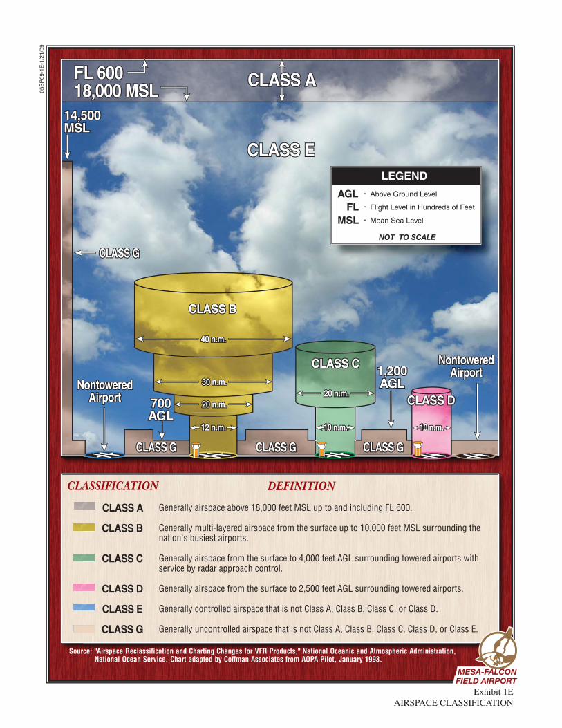
- Above Ground Level
- Flight Level in Hundreds of Feet
- Mean Sea Level
AGLFL
MSL
CLASSIFICATION DEFINITION
CLASS A
CLASS B
CLASS C
CLASS D
CLASS E
CLASS G
Generally airspace above 18,000 feet MSL up to and including FL 600.
Generally multi-layered airspace from the surface up to 10,000 feet MSL surrounding the nation's busiest airports.
Generally airspace from the surface to 4,000 feet AGL surrounding towered airports with service by radar approach control.
Generally airspace from the surface to 2,500 feet AGL surrounding towered airports.
Generally controlled airspace that is not Class A, Class B, Class C, or Class D.
Generally uncontrolled airspace that is not Class A, Class B, Class C, Class D, or Class E.
Exhibit 1EAIRSPACE CLASSIFICATION
05S
P09
-1E
-1/2
1/09
Source: "Airspace Reclassification and Charting Changes for VFR Products," National Oceanic and Atmospheric Administration, National Ocean Service. Chart adapted by Coffman Associates from AOPA Pilot, January 1993.
LEGEND
NOT TO SCALE
MESA-FALCONMESA-FALCONFIELD AIRPORTFIELD AIRPORTMESA-FALCONFIELD AIRPORT
1-29
control (ATC) facility to enter Class A airspace. In addition, the pilot must possess an instrument rating.
Class B airspace is controlled air-
space surrounding high-activity commercial service airports (i.e. Phoenix Sky Harbor International Airport). Class B airspace is de-signed to regulate the flow of un-controlled traffic, above, around, and below the arrival and departure airspace required for high perfor-mance, passenger-carrying aircraft at major airports. In order to fly within Class B airspace, an aircraft must be equipped with special radio and navigation equipment and must obtain clearance from air traf-fic control. A pilot is required to have at least a private pilot’s certif-icate or be a student pilot who has met the requirements of F.A.R. Part 61.95, which requires special ground and flight training for the Class B airspace. Aircraft are also required to utilize a Mode C trans-ponder within a 30 nautical mile range of the center of the Class B airspace. A Mode C transponder al-lows the ATCT to track the location and altitude of the aircraft.
Class C airspace is controlled air-
space surrounding lower-activity commercial service (i.e. Tucson In-ternational Airport) and some mili-tary airports. The FAA has estab-lished Class C airspace at 120 air-ports around the country, as a means of regulating air traffic in these areas. Class C airspace is de-signed to regulate the flow of un-controlled traffic above, around, and below the arrival and departure
airspace required for high-performance, passenger-carrying aircraft at major airports. To oper-ate inside Class C airspace, the air-craft must be equipped with a two-way radio and an encoding trans-ponder, and the pilot must have es-tablished communication with ATC.
Class D airspace is controlled air-
space surrounding most airports with an operating ATCT and not classified under B or C airspace de-signations. The Class D airspace typically constitutes a cylinder with a horizontal radius of four or five nautical mile from the airport, ex-tending from the surface up to a designated vertical limit, typically set at approximately 2,500 feet above the airport elevation. If an airport has an instrument approach or departure, the Class D airspace sometimes extends along the ap-proach or departure path.
All aircraft operating within Class A, B, C, and D airspace must be in con-stant contact with the air traffic con-trol facility responsible for that par-ticular airspace sector. Class E airspace is controlled air-
space surrounding an airport that encompasses all instrument ap-proach procedures and low-altitude federal airways. Only aircraft con-ducting instrument flights are re-quired to be in contact with the ap-propriate air traffic control facility when operating in Class E airspace. While aircraft conducting visual flights in Class E airspace are not required to be in radio contact with air traffic control facilities, visual flight can only be conducted if min-
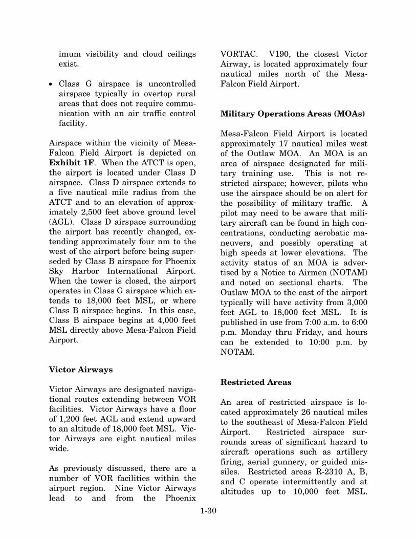
1-30
imum visibility and cloud ceilings exist.
Class G airspace is uncontrolled
airspace typically in overtop rural areas that does not require commu-nication with an air traffic control facility.
Airspace within the vicinity of Mesa-Falcon Field Airport is depicted on Exhibit 1F. When the ATCT is open, the airport is located under Class D airspace. Class D airspace extends to a five nautical mile radius from the ATCT and to an elevation of approx-imately 2,500 feet above ground level (AGL). Class D airspace surrounding the airport has recently changed, ex-tending approximately four nm to the west of the airport before being super-seded by Class B airspace for Phoenix Sky Harbor International Airport. When the tower is closed, the airport operates in Class G airspace which ex-tends to 18,000 feet MSL, or where Class B airspace begins. In this case, Class B airspace begins at 4,000 feet MSL directly above Mesa-Falcon Field Airport. Victor Airways Victor Airways are designated naviga-tional routes extending between VOR facilities. Victor Airways have a floor of 1,200 feet AGL and extend upward to an altitude of 18,000 feet MSL. Vic-tor Airways are eight nautical miles wide. As previously discussed, there are a number of VOR facilities within the airport region. Nine Victor Airways lead to and from the Phoenix
VORTAC. V190, the closest Victor Airway, is located approximately four nautical miles north of the Mesa-Falcon Field Airport. Military Operations Areas (MOAs) Mesa-Falcon Field Airport is located approximately 17 nautical miles west of the Outlaw MOA. An MOA is an area of airspace designated for mili-tary training use. This is not re-stricted airspace; however, pilots who use the airspace should be on alert for the possibility of military traffic. A pilot may need to be aware that mili-tary aircraft can be found in high con-centrations, conducting aerobatic ma-neuvers, and possibly operating at high speeds at lower elevations. The activity status of an MOA is adver-tised by a Notice to Airmen (NOTAM) and noted on sectional charts. The Outlaw MOA to the east of the airport typically will have activity from 3,000 feet AGL to 18,000 feet MSL. It is published in use from 7:00 a.m. to 6:00 p.m. Monday thru Friday, and hours can be extended to 10:00 p.m. by NOTAM. Restricted Areas An area of restricted airspace is lo-cated approximately 26 nautical miles to the southeast of Mesa-Falcon Field Airport. Restricted airspace sur-rounds areas of significant hazard to aircraft operations such as artillery firing, aerial gunnery, or guided mis-siles. Restricted areas R-2310 A, B, and C operate intermittently and at altitudes up to 10,000 feet MSL.
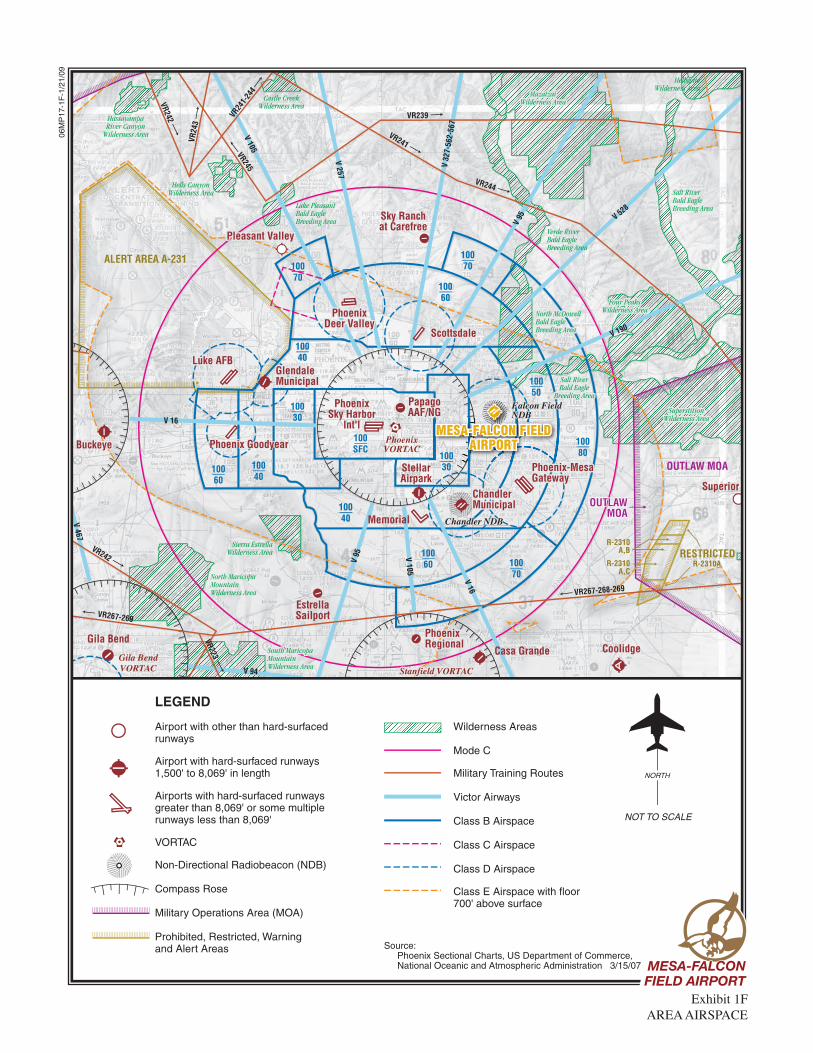
LEGEND
Airport with other than hard-surfacedrunways
Airport with hard-surfaced runways1,500' to 8,069' in length
Airports with hard-surfaced runwaysgreater than 8,069' or some multiplerunways less than 8,069'
VORTAC
Non-Directional Radiobeacon (NDB)
Compass Rose
Military Operations Area (MOA)
Prohibited, Restricted, Warning and Alert Areas
Wilderness Areas
Mode C
Military Training Routes
Victor Airways
Class B Airspace
Class C Airspace
Class D Airspace
Class E Airspace with floor700' above surface
Source: Phoenix Sectional Charts, US Department of Commerce, National Oceanic and Atmospheric Administration 3/15/07
NOT TO SCALE
NORTH
Exhibit 1FAREA AIRSPACE
Coolidge
Superior
PhoenixVORTAC
Gila BendVORTAC
Casa Grande
PhoenixPhoenixRegionalRegional
Phoenix-MesaGatewayGateway
Memorial
EstrellaSailport
Pleasant ValleyPleasant ValleyPleasant Valley
Sky Ranchat Carefree
Luke AFBLuke AFB
BuckeyeBuckeye
Gila Bend
StellarAirpark
PapagoPapagoAAF/NG
PhoenixSky Harbor
Int'l
Stanfield VORTACStanfield VORTAC
PhoenixRegional
Phoenix-MesaGateway
MESA-FALCON FIELDMESA-FALCON FIELDAIRPORTAIRPORT
MESA-FALCON FIELDAIRPORT
ChandlerChandlerMunicipalMunicipalChandlerMunicipal
GlendaleGlendaleMunicipalMunicipalGlendaleMunicipal
PhoenixPhoenixDeer ValleyDeer Valley
PhoenixDeer Valley
ScottsdaleScottsdaleScottsdale
Luke AFB
Buckeye
PapagoAAF/NG
Stanfield VORTAC
V 95 V 105
V 16V 190
V 528
V 95
V 32
7-56
2-56
7
V 257
V 105
V 16
V 467
V 94
VR267-268-269
VR242
VR242
VR24
3
VR239
VR241
VR244
VR24
1-24
4
VR245
VR223
VR267-269
OUTLAW MOA
RESTRICTED
ALERT AREA A-231
R-2310A
R-2310A,B
R-2310A,C
North MaricopaMountainWilderness Area
South MaricopaSouth MaricopaMountainMountainWilderness AreaWilderness Area
South MaricopaMountainWilderness Area
Sierra EstrellaWilderness Area
Verde RiverBald EagleBreeding Area
Lake PleasantBald EagleBreeding Area
Castle CreekWilderness Area
Hells CanyonWilderness Area
HassayampaRiver Canyon
Wilderness Area
Salt RiverBald EagleBreeding Area
HellsgateWilderness Area
BuckeyeVORTAC
SuperstitionSuperstitionWilderness AreaWilderness Area
Four PeaksFour PeaksWilderness AreaWilderness Area
Salt RiverSalt RiverBald EagleBald Eagle
Breeding AreaBreeding Area
North McDowellNorth McDowellBald EagleBald EagleBreeding AreaBreeding Area
MazatzaiMazatzaiWilderness AreaWilderness Area
SuperstitionWilderness Area
Four PeaksWilderness Area
Salt RiverBald Eagle
Breeding Area
North McDowellBald EagleBreeding Area
MazatzaiWilderness Area
10070
10030
100SFC
10030100
40
10040
10040
10060
10060 100
70
10080
10050
10070
10060
Signal MountainWilderness Area
Woolsey PeakWilderness Area
OUTLAWOUTLAWMOAMOA
OUTLAWMOA
Phoenix GoodyearPhoenix GoodyearPhoenix Goodyear
Falcon FieldFalcon FieldNDBNDBFalcon FieldNDB
Chandler NDBChandler NDBChandler NDB
06M
P17
-1F
-1/2
1/09
MESA-FALCONMESA-FALCONFIELD AIRPORTFIELD AIRPORTMESA-FALCONFIELD AIRPORT

1-31
While general aviation aircraft opera-tions are not prohibited, aircraft oper-ations are restricted during specified times and between the defined alti-tudes. Alert Areas Alert Area A-231 is located approx-imately 26 nautical miles to the northwest of the airport. This alert area is associated with Luke Air Force Base and is likely to have high concen-trations of military jet aircraft per-forming training maneuvers. The mil-itary activity in this area operates at lower altitudes and may occur any-time of the day or night. General avi-ation flights are not restricted within this Alert Area, but pilots are strongly cautioned to be alert for high-speed military training aircraft. Military Training Routes A Military Training Route, or MTR, is a long, low-altitude corridor that serves as a flight path for military air-craft. The corridor is often 10 miles wide, 70 to 100 miles long, and may range from 500 feet to 1,500 feet above ground level; occasionally, they are higher. There are several MTRs lo-cated in the vicinity of the airport, with the closest being approximately 22 nautical miles to the south. Gener-al aviation pilots should be aware of the locations of the MTRs and exercise special caution if they need to cross them.
Boeing Flight Test Area Located immediately to the north of Mesa-Falcon Field Airport is The Boe-ing Company, which manufactures helicopters and conducts flight tests on a regular basis. A large area northeast of the airport has been set aside for the flight testing of these air-craft. Between ground level and 14,500 feet MSL, it can be expected that these aircraft will be conducting routine flight testing operations from sunrise to sunset Monday thru Satur-day. Local Operating Procedures Mesa-Falcon Field Airport is situated at 1,394 feet MSL. The traffic pattern at the airport is maintained to provide the safest and most efficient use of the airspace surrounding the airport. The airport utilizes a right-hand traffic pattern for Runways 4R and 22R and a standard left-hand traffic pattern for Runways 4L and 22L. These traffic patterns are intended to keep proper separation of aircraft while being able to utilize both parallel runways. There is a large amount of flight train-ing conducted at the airport, which re-sults in several touch-and-go aircraft operations. There are also a large number of heli-copter operations at the airport due to the manufacturing of military and ci-vilian helicopters on and adjacent to the airport. Flight training of these helicopters occurs on the north side of Runway 4L-22R in areas adjacent to Taxiway E.

1-32
The ATCT asks that these helicopters utilize a tight traffic pattern to the north of this area when possible at an altitude of 1,900 feet MSL. The traffic pattern for high-performance aircraft, including jets, is at 2,900 feet MSL. The traffic pattern altitude for smaller turbine and piston aircraft is 2,400 feet MSL. Pilots operating in and out of Mesa Falcon-Field Airport are encouraged to adhere to the voluntary Falcon Field Noise Abatement Program which has adopted NBAA and AOPA noise awareness recommendations. Obstructions: Runway 4R has a road located 530 feet from the runway end. It is 305 feet left of the runway center-line. Pilots should implement a 31:1 approach slope angle to clear the ob-struction. Runway 22L has a 45-foot tall tree, 1,200 feet from the runway end, which is 335 feet right of the cen-terline. Pilots should implement a 22:1 approach slope to safely clear the obstruction. Runway 4L has an 18-foot tall pole located 597 feet from the end of the runway that is 66 feet left of the centerline. An approach slope an-gle of 22:1 should be used to clear the obstruction. Finally, Runway 22R has a road 16 feet tall located 600 feet from the runway end. It is 165 feet right of the centerline and can be cleared with a 25:1 approach angle. REGIONAL AIRPORTS There are a number of airports of var-ious size, capacities, and functions within the vicinity of Mesa-Falcon Field Airport, as indicated on Exhibit
1F. It is important to consider the ca-pabilities and limitations of other air-ports when planning for future changes or improvements at Mesa-Falcon Field Airport. In an urban set-ting, airports within 30 nautical miles of each other will generally have some influence on the activity of the other airport. The following are those pub-lic-use airports with asphalt or con-crete runways that can serve general aviation aircraft and are important to the airspace and control environment of the area. Information pertaining to each airport was obtained from FAA Form 5010-1, Airport Master Record. Table 1H identifies the major charac-teristics of each airport. Phoenix-Mesa Gateway Airport (IWA) is located approximately 10 nautical miles southeast of Mesa-Falcon Field Airport. It is owned and operated by the Williams Gateway Airport Authority. The airport is served by three parallel runways, with Runway 12R-30L providing the great-est runway length at 10,401 feet. The airport reports 115 based aircraft, in-cluding 19 jets and 21 helicopters. Served by an ATCT, the airport had 280,700 operations in 2006. The air-port is a converted Air Force Base, with long range planning calling for support of air carrier service, general aviation, and cargo operators. One FBO is located on the field that pro-vides a variety of aviation services in-cluding full-service fuel, minor main-tenance, and tiedown spaces. Several instrument approaches are available at the airport, including a precision instrument landing system (ILS) ap-proach to Runway 30C.
1-33
TABLE 1H Regional Airport Data Mesa-Falcon Field Airport
Airport Name
FAA
Classification
Distance
(nm)
Longest Runway
Based
Aircraft
Annual Operations
(2006) Phoenix-Mesa Gateway GA Reliever 10 10,400 114 280,700 Chandler Municipal GA Reliever 12 4,870 449 269,100 Scottsdale GA Reliever 13 8,250 471 196,300 Stellar Airpark GA 14 3,900 152 39,000 Phoenix Sky Harbor International
Commercial 14 11,500 117 546,300
Memorial Airfield GA - Private 15 8,650 17 2,300 Phoenix Deer Valley GA Reliever 22 8,200 1,149 406,500 Glendale Municipal GA Reliever 29 7,150 378 150,800 Phoenix Regional GA 30 5,000 12 N/A Source: FAA Form 5010-1, Airport Master Record; FAA Air Traffic Activity System (ATADS)
Chandler Municipal Airport (CHD), located approximately 12 nautical miles to the southwest of Me-sa-Falcon Field Airport, is owned and operated by the City of Chandler. The airport is equipped with two parallel runways similar to Mesa-Falcon Field Airport. Runway 4L-22R is 4,401 feet long, and Runway 4R-22L is 4,870 feet long. Approximately 449 aircraft are based at the airport, including 50 mul-ti-engine aircraft and 24 helicopters. The airport is served by an ATCT and reported 269,100 aircraft operations in 2006. One major FBO on the field provides an array of services, includ-ing full-service fueling, maintenance, aircraft rental, flight training, and pi-lot supplies. The City of Chandler also provides self-serve Avgas fuel. The airport is served by three non-precision instrument approaches. Scottsdale Airport (SDL) is located 13 nautical miles northwest of Mesa-Falcon Field Airport and is owned and operated by the City of Scottsdale. It has one runway which is 8,249 feet
long. A control tower is located on the field which reported approximately 196,300 aircraft operations in 2006. The airport reports 471 based aircraft, including 96 jets, 89 multi-engine air-craft, and 10 helicopters. Three FBOs are located on the field, providing a variety of aviation services, including full-service fuel, aircraft maintenance and avionics, a pilot’s lounge, aircraft rental, and courtesy transportation. Three non-precision instrument ap-proaches serve the airport. Stellar Airpark (P19) is a privately owned airport that is open to public use. It is located approximately 14 nautical miles southwest of Mesa-Falcon Field Airport and has one run-way that is 3,913 feet long. Approx-imately 152 aircraft are reported to be based at the airport, including five jets and ten multi-engine aircraft. The airport reported 39,000 aircraft opera-tions in 2005. The local FBO provides self-service Avgas fuel, aircraft main-tenance, tiedowns, and pilot supplies
1-34
to its customers. One circling non-precision approach serves the airport. Phoenix Sky Harbor International Airport (PHX) is located 14 nautical miles west of Mesa-Falcon Field Air-port in the heart of Phoenix. The air-port is owned and operated by the City of Phoenix and is the largest air carri-er airport within the State of Arizona, and one of the largest air carrier air-ports within the United States. Sky Harbor is served by all of the major airlines, with Southwest and USAir-ways utilizing the airport as a hub. Phoenix Sky Harbor International Airport is equipped with three parallel runways, two of which are over 10,000 feet long. An array of instrument ap-proach aids, including an ILS, serve the airport and aid pilots on approach during inclement weather conditions. The airport is served by 17 published instrument approaches, three of which provide Category I (CAT I) weather minimums (200-foot cloud ceiling and one-half mile visibility). Although the airport’s primary role is to provide commercial service to the area, the airport also serves general aviation activity. Approximately 117 aircraft are considered to be based at the airport, including 28 jets and 22 helicopters. In 2006, over 546,000 air-craft operations were reported, with a large majority of these being commer-cial aircraft. Major FBO services are also provided at the airport. Memorial Airfield is a privately owned, private use airport located ap-proximately 15 nautical miles south-west of Mesa-Falcon Field Airport. The most current data found pertain-
ing to the airport shows that it is served by an 8,560-foot runway. Ap-proximately 17 aircraft are based at the airport and limited services are present at the facility. Phoenix Deer Valley Airport (DVT), located approximately 22 nautical miles northwest of Mesa-Falcon Field Airport, is also owned and operated by the City of Phoenix. It is served by parallel runways, with Runway 7R-25L providing the great-est length at 8,208 feet. Approximate-ly 1,149 based aircraft are reported at the airport, making it one of the larg-est airports regarding based aircraft in the country. Of this number, 125 multi-engine aircraft and 19 helicop-ters are included, and ironically, no jets are considered to be based at the airport. The airport is equipped with a control tower, which reported 406,500 aircraft operations in 2006. One major FBO is located on the field that provides full-service fueling capa-bility, aircraft maintenance, a pilot’s lounge, aviation accessories, and air-craft cleaning. There are four non-precision instrument approaches ap-proved for use into the airport. Glendale Municipal Airport (GEU) is located 29 nautical miles west of Mesa-Falcon Field Airport. It is owned and operated by the City of Glendale, and provides one runway that is 7,150 feet long. The airport is home to 378 aircraft, including five jets and 21 helicopters. It is equipped with an ATCT that reported approx-imately 150,800 aircraft operations in 2006. FBO services are provided at the airport, including full-service fuel, a pilot’s lounge, courtesy transporta-

1-35
tion, and aircraft avionics service. One non-precision instrument ap-proach serves the airport. Phoenix Regional Airport (A39) is located approximately 30 nautical miles to the southwest of Mesa-Falcon Field Airport. It is a privately owned airport that is open to public use. One 5,000-foot-long runway serves the air-port. The airport has 12 aircraft based on the field. There are limited services available at the airport to in-clude self-service Avgas fuel. There are no instrument approaches ap-proved for use into the airport. SOCIOECONOMIC CHARACTERISTICS Socioeconomic characteristics are col-lected and examined to derive an un-derstanding of the dynamics of growth within the study area. This informa-tion is essential in determining avia-tion demand level requirements, as most general aviation demand can be directly related to the socioeconomic condition of the area. Statistical anal-ysis of population, employment, and income trends define the economic
strength of the region and the ability of the region to sustain a strong eco-nomic base over an extended period of time. Whenever possible, local or regional data is used for analysis. Historical and forecast data were primarily ob-tained from the Maricopa Association of Governments (MAG), which is the regional metropolitan planning organ-ization (MPO), and the City of Mesa and the Arizona Department of Eco-nomic Security. Other resources in-cluded the U.S. Census Bureau, the Bureau of Labor Statistics, as well as pertinent internet sites. POPULATION Population is one of the most impor-tant socioeconomic factors to consider when planning for future needs of an airport. Historical and forecast trends in population provide an indication of the potential of the region to sustain growth in aviation activity. Historical population data for the City of Mesa, Maricopa County, and the State of Arizona is shown in Table 1J.
TABLE 1J Historical Population Statistics
1990
2000
2005
2006 Average Annual
Growth Rate City of Mesa MPA 329,745* 441,800 486,296 492,657 2.54% Maricopa County 2,122,101 3,072,149 3,700,516 3,792,670 3.70% State of Arizona 3,665,228 5,130,632 5,829,839 6,166,318 3.30% United States 248,709,873 281,421,906 296,507,061 299,398,484 1.17% MPA: Municipal Planning Area *Estimated MPA Population Source: MAG; U.S. Census Bureau
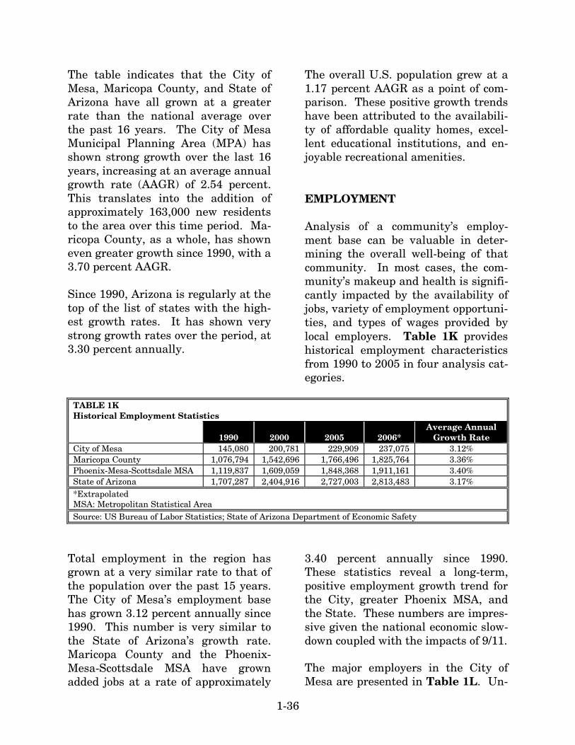
1-36
The table indicates that the City of Mesa, Maricopa County, and State of Arizona have all grown at a greater rate than the national average over the past 16 years. The City of Mesa Municipal Planning Area (MPA) has shown strong growth over the last 16 years, increasing at an average annual growth rate (AAGR) of 2.54 percent. This translates into the addition of approximately 163,000 new residents to the area over this time period. Ma-ricopa County, as a whole, has shown even greater growth since 1990, with a 3.70 percent AAGR. Since 1990, Arizona is regularly at the top of the list of states with the high-est growth rates. It has shown very strong growth rates over the period, at 3.30 percent annually.
The overall U.S. population grew at a 1.17 percent AAGR as a point of com-parison. These positive growth trends have been attributed to the availabili-ty of affordable quality homes, excel-lent educational institutions, and en-joyable recreational amenities. EMPLOYMENT Analysis of a community’s employ-ment base can be valuable in deter-mining the overall well-being of that community. In most cases, the com-munity’s makeup and health is signifi-cantly impacted by the availability of jobs, variety of employment opportuni-ties, and types of wages provided by local employers. Table 1K provides historical employment characteristics from 1990 to 2005 in four analysis cat-egories.
TABLE 1K Historical Employment Statistics
1990
2000
2005
2006* Average Annual
Growth Rate City of Mesa 145,080 200,781 229,909 237,075 3.12% Maricopa County 1,076,794 1,542,696 1,766,496 1,825,764 3.36% Phoenix-Mesa-Scottsdale MSA 1,119,837 1,609,059 1,848,368 1,911,161 3.40% State of Arizona 1,707,287 2,404,916 2,727,003 2,813,483 3.17% *Extrapolated MSA: Metropolitan Statistical Area Source: US Bureau of Labor Statistics; State of Arizona Department of Economic Safety
Total employment in the region has grown at a very similar rate to that of the population over the past 15 years. The City of Mesa’s employment base has grown 3.12 percent annually since 1990. This number is very similar to the State of Arizona’s growth rate. Maricopa County and the Phoenix-Mesa-Scottsdale MSA have grown added jobs at a rate of approximately
3.40 percent annually since 1990. These statistics reveal a long-term, positive employment growth trend for the City, greater Phoenix MSA, and the State. These numbers are impres-sive given the national economic slow-down coupled with the impacts of 9/11. The major employers in the City of Mesa are presented in Table 1L. Un-
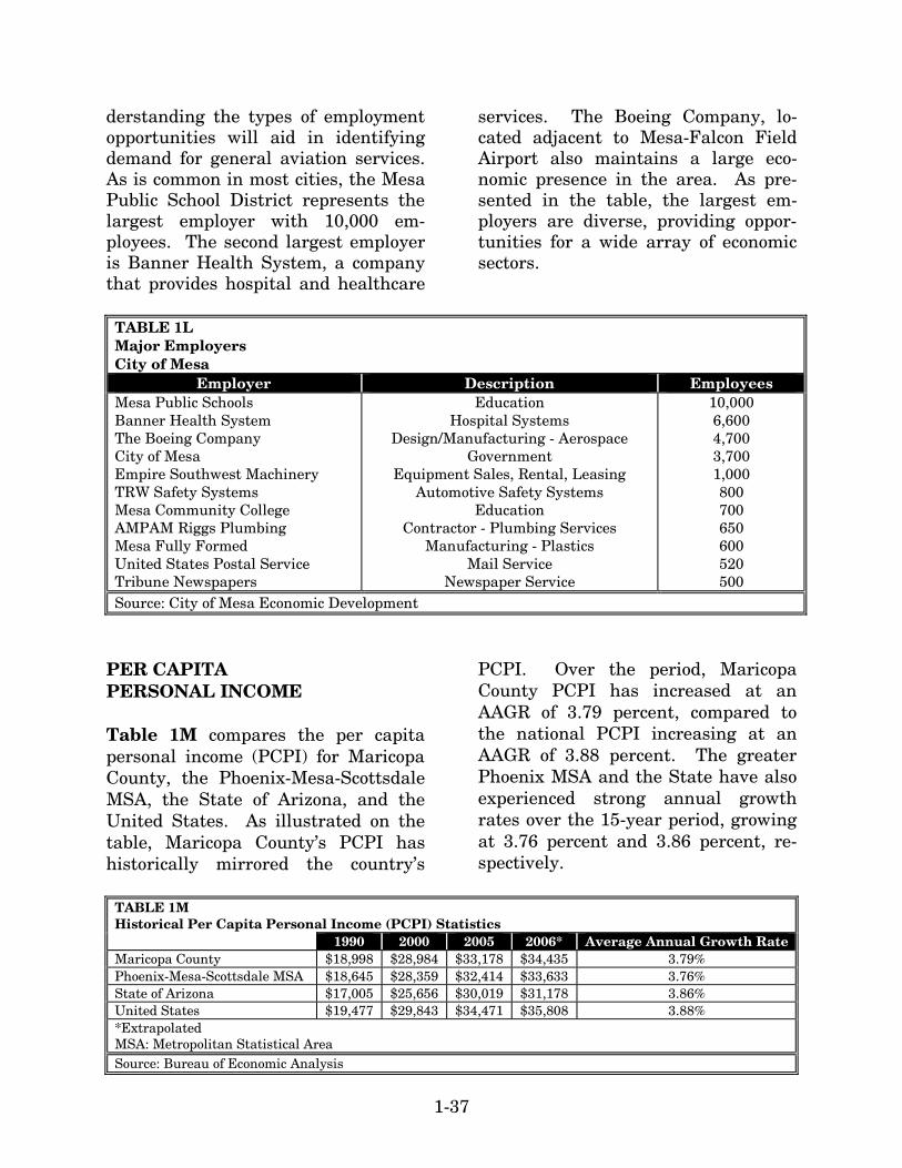
1-37
derstanding the types of employment opportunities will aid in identifying demand for general aviation services. As is common in most cities, the Mesa Public School District represents the largest employer with 10,000 em-ployees. The second largest employer is Banner Health System, a company that provides hospital and healthcare
services. The Boeing Company, lo-cated adjacent to Mesa-Falcon Field Airport also maintains a large eco-nomic presence in the area. As pre-sented in the table, the largest em-ployers are diverse, providing oppor-tunities for a wide array of economic sectors.
TABLE 1L Major Employers City of Mesa
Employer Description Employees Mesa Public Schools Banner Health System The Boeing Company City of Mesa Empire Southwest Machinery TRW Safety Systems Mesa Community College AMPAM Riggs Plumbing Mesa Fully Formed United States Postal Service Tribune Newspapers
Education Hospital Systems
Design/Manufacturing - Aerospace Government
Equipment Sales, Rental, Leasing Automotive Safety Systems
Education Contractor - Plumbing Services
Manufacturing - Plastics Mail Service
Newspaper Service
10,000 6,600 4,700 3,700 1,000 800 700 650 600 520 500
Source: City of Mesa Economic Development
PER CAPITA PERSONAL INCOME Table 1M compares the per capita personal income (PCPI) for Maricopa County, the Phoenix-Mesa-Scottsdale MSA, the State of Arizona, and the United States. As illustrated on the table, Maricopa County’s PCPI has historically mirrored the country’s
PCPI. Over the period, Maricopa County PCPI has increased at an AAGR of 3.79 percent, compared to the national PCPI increasing at an AAGR of 3.88 percent. The greater Phoenix MSA and the State have also experienced strong annual growth rates over the 15-year period, growing at 3.76 percent and 3.86 percent, re-spectively.
TABLE 1M Historical Per Capita Personal Income (PCPI) Statistics 1990 2000 2005 2006* Average Annual Growth Rate Maricopa County $18,998 $28,984 $33,178 $34,435 3.79% Phoenix-Mesa-Scottsdale MSA $18,645 $28,359 $32,414 $33,633 3.76% State of Arizona $17,005 $25,656 $30,019 $31,178 3.86% United States $19,477 $29,843 $34,471 $35,808 3.88% *Extrapolated MSA: Metropolitan Statistical Area Source: Bureau of Economic Analysis
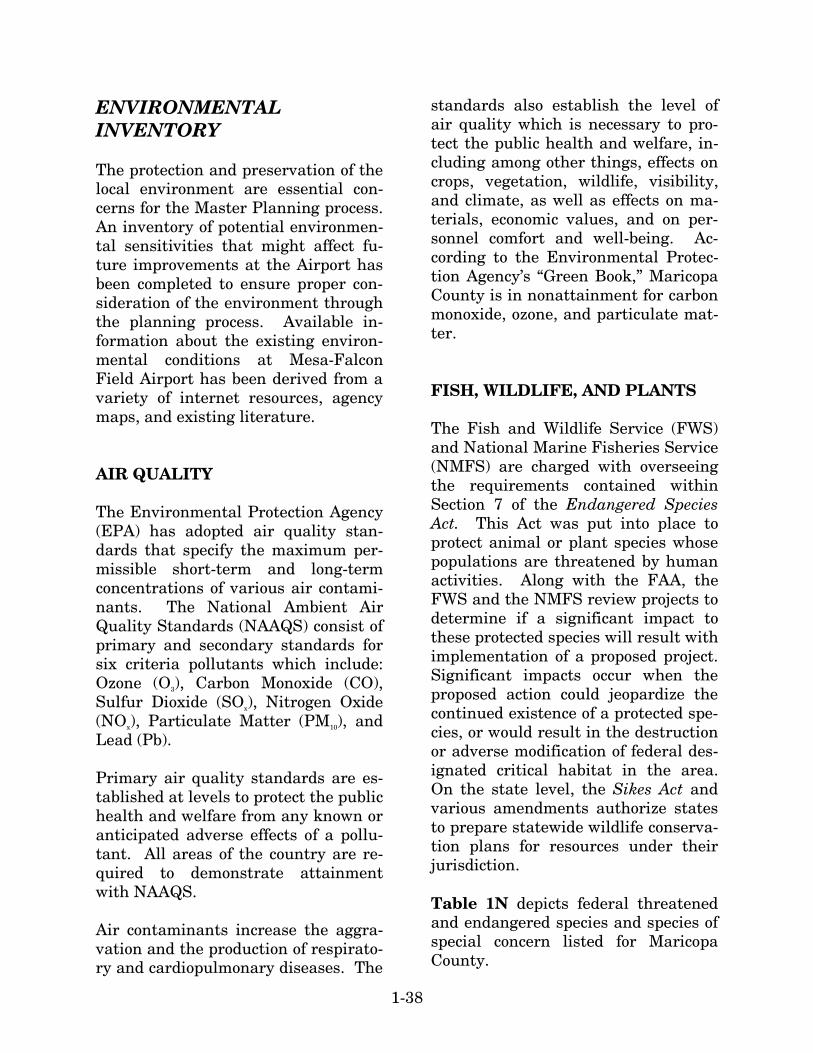
1-38
ENVIRONMENTAL INVENTORY The protection and preservation of the local environment are essential con-cerns for the Master Planning process. An inventory of potential environmen-tal sensitivities that might affect fu-ture improvements at the Airport has been completed to ensure proper con-sideration of the environment through the planning process. Available in-formation about the existing environ-mental conditions at Mesa-Falcon Field Airport has been derived from a variety of internet resources, agency maps, and existing literature. AIR QUALITY The Environmental Protection Agency (EPA) has adopted air quality stan-dards that specify the maximum per-missible short-term and long-term concentrations of various air contami-nants. The National Ambient Air Quality Standards (NAAQS) consist of primary and secondary standards for six criteria pollutants which include: Ozone (O3), Carbon Monoxide (CO), Sulfur Dioxide (SOx), Nitrogen Oxide (NOx), Particulate Matter (PM10), and Lead (Pb). Primary air quality standards are es-tablished at levels to protect the public health and welfare from any known or anticipated adverse effects of a pollu-tant. All areas of the country are re-quired to demonstrate attainment with NAAQS. Air contaminants increase the aggra-vation and the production of respirato-ry and cardiopulmonary diseases. The
standards also establish the level of air quality which is necessary to pro-tect the public health and welfare, in-cluding among other things, effects on crops, vegetation, wildlife, visibility, and climate, as well as effects on ma-terials, economic values, and on per-sonnel comfort and well-being. Ac-cording to the Environmental Protec-tion Agency’s “Green Book,” Maricopa County is in nonattainment for carbon monoxide, ozone, and particulate mat-ter. FISH, WILDLIFE, AND PLANTS The Fish and Wildlife Service (FWS) and National Marine Fisheries Service (NMFS) are charged with overseeing the requirements contained within Section 7 of the Endangered Species Act. This Act was put into place to protect animal or plant species whose populations are threatened by human activities. Along with the FAA, the FWS and the NMFS review projects to determine if a significant impact to these protected species will result with implementation of a proposed project. Significant impacts occur when the proposed action could jeopardize the continued existence of a protected spe-cies, or would result in the destruction or adverse modification of federal des-ignated critical habitat in the area. On the state level, the Sikes Act and various amendments authorize states to prepare statewide wildlife conserva-tion plans for resources under their jurisdiction. Table 1N depicts federal threatened and endangered species and species of special concern listed for Maricopa County.
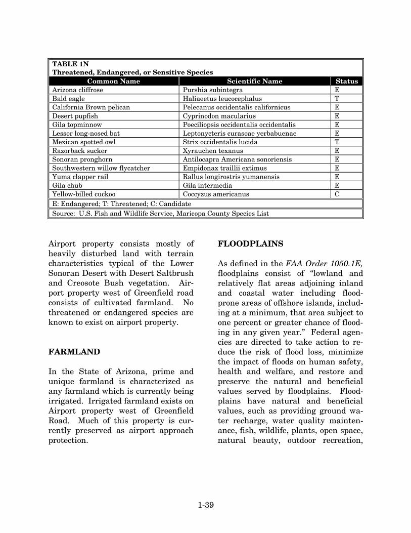
1-39
TABLE 1N Threatened, Endangered, or Sensitive Species
Common Name Scientific Name Status Arizona cliffrose Purshia subintegra E Bald eagle Haliaeetus leucocephalus T California Brown pelican Pelecanus occidentalis californicus E Desert pupfish Cyprinodon macularius E Gila topminnow Poeciliopsis occidentalis occidentalis E Lessor long-nosed bat Leptonycteris curasoae yerbabuenae E Mexican spotted owl Strix occidentalis lucida T Razorback sucker Xyrauchen texanus E Sonoran pronghorn Antilocapra Americana sonoriensis E Southwestern willow flycatcher Empidonax traillii extimus E Yuma clapper rail Rallus longirostris yumanensis E Gila chub Gila intermedia E Yellow-billed cuckoo Coccyzus americanus C E: Endangered; T: Threatened; C: Candidate Source: U.S. Fish and Wildlife Service, Maricopa County Species List
Airport property consists mostly of heavily disturbed land with terrain characteristics typical of the Lower Sonoran Desert with Desert Saltbrush and Creosote Bush vegetation. Air-port property west of Greenfield road consists of cultivated farmland. No threatened or endangered species are known to exist on airport property. FARMLAND In the State of Arizona, prime and unique farmland is characterized as any farmland which is currently being irrigated. Irrigated farmland exists on Airport property west of Greenfield Road. Much of this property is cur-rently preserved as airport approach protection.
FLOODPLAINS As defined in the FAA Order 1050.1E, floodplains consist of “lowland and relatively flat areas adjoining inland and coastal water including flood-prone areas of offshore islands, includ-ing at a minimum, that area subject to one percent or greater chance of flood-ing in any given year.” Federal agen-cies are directed to take action to re-duce the risk of flood loss, minimize the impact of floods on human safety, health and welfare, and restore and preserve the natural and beneficial values served by floodplains. Flood-plains have natural and beneficial values, such as providing ground wa-ter recharge, water quality mainten-ance, fish, wildlife, plants, open space, natural beauty, outdoor recreation,
1-40
agriculture and forestry. FAA Order 1050.1E (12) (c) indicates that “if the proposed action and reasonable alter-natives are not within the limits of a base floodplain (100-year flood area),” that it may be assumed that there are no floodplain impacts. The limits of base floodplains are determined by Flood Insurance Rate Maps (FIRM) prepared by the Federal emergency Management Agency (FEMA). According to the FIRM map panel number 04013C2205G, a 100-year floodplain associated with Roosevelt Canal is located west of the airfield. HAZARDOUS MATERIALS AND SOLID WASTE Four primary laws have been passed governing the handling and disposal of hazardous materials, chemicals, sub-stances, and wastes. The two statutes of most importance to the FAA in pro-posing actions to construct and oper-ate facilities and navigational aids are the Resource Conservation Recovery Act (RCRA) (as amended by the Fed-eral Facilities Compliance Act of 1992) and the Comprehensive Environmental Responses, Compensation, Liability Act (CERCLA), as amended (also known as Superfund). RCRA governs the generation, treatment, storage, and disposal of hazardous wastes. CERCLA provides for cleanup of any release of a hazardous substance (ex-cluding petroleum) into the environ-ment. In evaluating potential impacts within this resource category, significant im-pact determinations are typically only
made when a resource agency, such as the Arizona Department of Environ-mental Quality, has indicated that it would be difficult to issue a permit for the proposed development. A signifi-cant impact may also be realized if the proposed action would affect a proper-ty listed on the National Priorities List (NPL) which is the list of hazard-ous waste sites in the United States that are eligible for long-term remedi-al action financed under the federal Superfund program. No sites listed on the NPL are located on or in the vicin-ity of the airport. Additionally, no ac-tive Superfund sites are present. Solid waste disposal facilities can cause a hazard to aircraft by attract-ing wildlife and, most importantly, birds. A bird hazard exists if a landfill is located approximately 5,000 feet from runways used by piston aircraft and 10,000 feet from runways used by turbojet aircraft. There are no solid waste disposal facilities within 10,000 feet of the airport. DEPARTMENT OF TRANSPORTATION SECTION 4(f) RESOURCES Section 4(f) properties include publicly owned parks, recreational areas, wild-life and waterfowl refuges of national, state, or local significance or land of a historic site of a national, state, or lo-cal significance. Falcon Field Park, located on airport property, is owned by the City of Me-sa. Several memorial plaques, as well as the fireplace and chimney from the remains of the cadet lounge, are lo-
1-41
cated within this park. Several golf courses are within the immediate vi-cinity of the airport: Longbow Golf Course is located northeast of the air-port and several holes are located within the existing 65 DNL; Apache Wells Golf Course is east of the air-port; and Alta Mesa Country Club Golf Course is located southeast of the air-port. Gene Autry Park is located southwest of the airport. HISTORICAL AND CULTURAL RESOURCES No cultural or historical surveys have been completed at the airport. Be-cause of its significance during World War II, structures remaining from that period may be eligible for listing on the National Register of Historic Places. A fireplace and chimney, which was once part of the cadet lounge dating back to when the airport was a WWII training facility, remains located in the Falcon Field Park. Ad-ditionally, several memorial plaques are located in this park. Cultural surveys may need to be con-ducted before construction. In addi-tion, if any undocumented buried cul-tural resource should be encountered, all ground disturbing activities should stop immediately and the remains should be evaluated. WATER SUPPLY AND QUALITY The City of Mesa provides potable water and wastewater service to the City. The City’s water treatment fa-cilities process 91 million gallons of water on an average day, with a peak
production of nearly 138 million gal-lons per day. When additional water is needed, groundwater from City wells – each between 800 and 1,000 feet deep – is pumped and distributed to the zones. The City of Mesa operates under a National Pollutant Discharge Elimi-nation System (NPDES) Permit that allows the discharge of treated wastewater into the Salt River. This permitting process provides a me-chanism to require the implementa-tion of controls designed to prevent harmful pollutants from being washed by stormwater runoff into lo-cal water bodies. WETLANDS The U.S. Army Corps of Engineers (COE) regulates the discharge of dredge and/or fill material into waters of the United States, including adja-cent wetlands, under Section 404 of the Clean Water Act. Wetlands are defined by Executive Or-der 11990, Protection of Wetlands, as “those areas that are inundated by surface or groundwater with a fre-quency sufficient to support and under normal circumstances does or would support a prevalence of vegetation or aquatic life that requires saturated or seasonally saturated soil conditions for growth and reproduction.” Catego-ries of wetlands includes swamps, marshes, bogs, sloughs, potholes, wet meadows, river overflows, mud flats, natural ponds, estuarine areas, tidal overflows, and shallow lakes and ponds with emergent vegetation. Wet-lands exhibit three characteristics:

1-42
hydrology, hydrophytes (plants able to tolerate various degrees of flooding or frequent saturation), and poorly drained soils. No known wetlands are located on airport property. A wetland survey may need to be completed in order to determine if any jurisdictional wet-lands or Waters of the U.S. are located on airport property. WILD AND SCENIC RIVERS The Verde River is the only wild and scenic river in Arizona. This river is not in the proximity to the airport. DOCUMENT SOURCES As mentioned earlier, a variety of dif-ferent sources were utilized in the in-ventory process. The following listing reflects a partial compilation of these sources. This does not include data provided by airport management as part of their records, nor does it in-clude airport drawings and photo-graphs which were referenced for in-formation. On-site inventory and in-terviews with staff and tenants con-tributed to the inventory effort. Airport/Facility Directory, Southwest, U.S. Department of Transportation, Federal Aviation Administration, Na-tional Aeronautical Charting Office, May 10, 2007 Edition. Phoenix Sectional Aeronautical Chart, U.S. Department of Transportation, Federal Aviation Administration, Na-
tional Aeronautical Charting Office, May 10, 2007. National Plan of Integrated Airport Systems (NPIAS), U.S. Department of Transportation, Federal Aviation Ad-ministration, 2007-20011. U.S. Terminal Procedures, Southwest U.S., U.S. Department of Transporta-tion, Federal Aviation Administration, National Aeronautical Charting Of-fice, May 10, 2007. City of Mesa Transportation Plan – A Shared Vision 2025. City of Mesa. 2003. City of Mesa General Plan – A Shared Vision 2025. City of Mesa. 2002 City of Mesa Zoning Map. City of Me-sa – Planning Division. September 2003. Falcon Field Land Use Guidelines. City of Mesa – Community Develop-ment Department. May 1994. Falcon Field Sub-Area Plan. City of Mesa – Planning Division. April 2007. A number of internet websites were also used to collect information for the inventory chapter. These include the following: City of Mesa: www.cityofmesa.org City of Mesa Chamber of Commerce: www.mesachamber.org
1-43
FAA 5010 Airport Master Record Da-ta: http://www.airnav.com Maricopa Association of Governments: http://www.mag.maricopa.gov/display.cms U.S. Census Bureau: http://www.census.gov Maricopa County, Arizona http://www.maricopa.gov/
Arizona Department of Economic Se-curity http://www.de.state.az.us/ASPNew/default.asp Arizona Workforce Informer http://www.workforce.az.gov/ Bureau of Economic Analysis, U.S. Department of Commerce http://www.bea.gov/bea/regional/data.htm


