33
Monitoring the impact of gold mining on the forest cover and fresh water- Suriname Cayenne, 26 November 2014,Djojodikromo Mark & Crabbe Sarah

Monitoring the impact of gold mining on the forest cover and fresh water- Suriname
Cayenne, 26 November 2014,Djojodikromo Mark & Crabbe Sarah

Country background• Independent: November 25th 1975
• Capital : Paramaribo
• Official language : Dutch
• Land surface : 16.4 million ha (164.000 km²)
• Population: 530,000
• Culture: very diverse population
• Contribution of forestry: 1.3%
• Main contributor: mining sector
• Forest cover > 90%
• Forest occurrences/capita: 28 ha
• Deforestation rate: 0,02-0,03%

General information - gold sector in Suriname•First half of 2013 production of gold: 531.000 troy ounce•95% of the total export value is composed of mining (gold, bauxite, oil, gravel) (IMF,2010)•Production of large scale vs small scale gold mining: ca. 40%-60%•In first half of 2013 there was a decrease in large scale mining of 9% but an increase of small scale mining of 7%

General information - gold sector in Suriname
•65-75% of the gold miners are migrants
• ca. 40000 persons are active in the gold sector (direct and indirect)
•Different systems of management:•Concessionaire exploit his own concession
•Other people exploit the concession, but the concessionaire is present
•Other people exploit the concession, while the concessionaire is absent
•Traditional area

Geographical distribution of gold mining

Geographical distribution of gold mining

Geographical distribution of gold mining

Different methods of gold mining in Suriname
• Alluvial goldmining – secondary deposits• mostly mined by SSM enterprises or individuals.
Different steps1) Exploration: digging pits of 2-3m deep2) Deforestation: clearing of ca. 1ha3) Removing the top layer4) Washing of the gold-bearing layer5) Washing sluice box 6) Separating the gold from the mercury
Equipment used: beside the hydraulic pumps, also very often heavy machinery (e.g. Excavators)
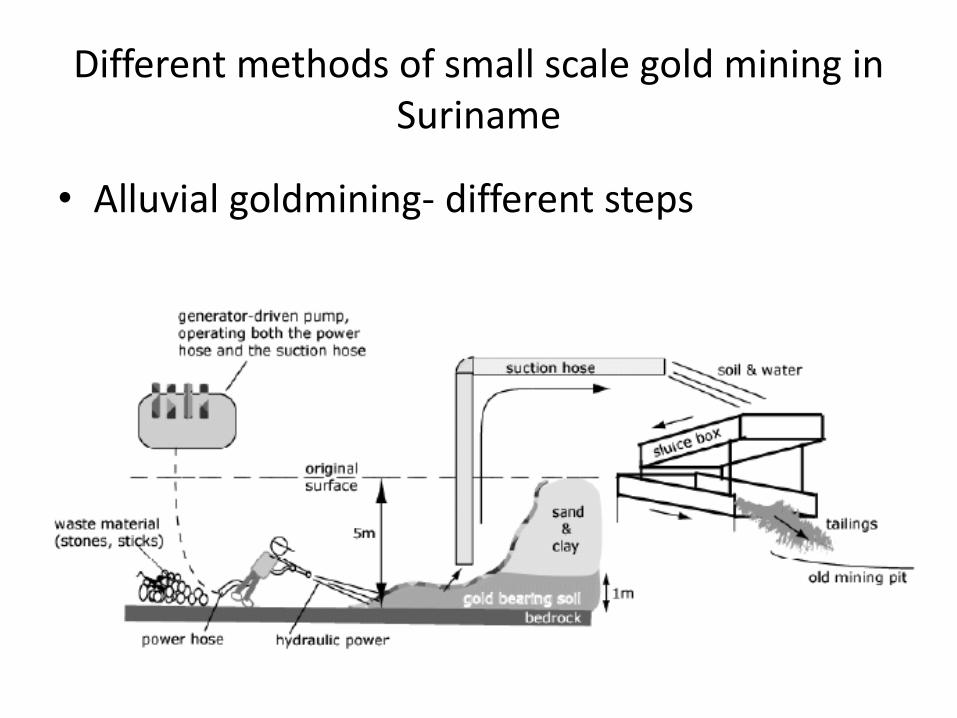
Different methods of small scale gold mining in Suriname
• Alluvial goldmining- different steps

Different methods of gold mining in Suriname
• Primary gold mining- primary or lode (vein) deposites
– Also hydraulic method
– exploited by medium- and large-scale hard rock mining enterprises
– This method will most probably increase in the future

Different methods of gold mining in Suriname
• Dredging (on rivers)- forbidden by law

Establishment of “Commissie Ordening Goudsector” (Regulation goldsector)
• Mandate: “Transform gold-mining sector into a formal economy sector, orderly structures, complying with existing laws and employs only legal and tax-paying residents”
• Activities: Registration of the persons active in the gold mining sector, clean sweeps, removal of illegal miners
• Also: Recording of GPS-points in the field, indicating the locations of the mines.

Within ACTO-project: ”Monitoring deforestation, land use change and logging in the Panamazon forest”:
Carried out activities 2012-now1. Capacity building in various
subject (RS, GIS, Qa/Qc, Radar, programming...)
2. Establishement of the Forest Cover Monitoring Unit
3. Exchange of knowledge amongst countries
4. Development of the FCM-plan5. Development of the method
Establishment of the Forest Cover Monitoring Unit

Methodology to monitor deforestation
Original Images Cloudfree mosaics
First draft forest cover map
Preliminary deforestation map
QA/QC
Not validated
Validated
Final deforestation map
Developped method
Method in development
Method being tested

Methodology to monitor deforestation
• Basic concepts:– Original Images: Landsat Images, currently Landsat 8
(and in the future other freely available images)– Minimum Mapping Unit : 1 hectare– Classes: Forest, Non-forest, Deforestation, No Data
(Clouds), Shifting Cultivation, Hydrology– Projection: WGS 84, UTM 21N– Used software through the process: Open source
software e.g. Rstudio, QGIS, TerraAmazon, PostGres, PostGIS
– Years: 2000 & 2009 (Preliminary map finished, currently Qa/Qc), 2013 (in process), 2014 (planned)

Methodology to monitor deforestation
Original Images Cloudfree mosaics
First draft forest cover map
Preliminary deforestation map
QA/QC
Not validated
Validated
Final deforestation map
Developped method
Method in development
Method being tested

Methodology to monitor deforestationCreation of “Cloudfree” Mosaics
• Why?(example of the “best” images for one scene in 2013)

Methodology to monitor deforestation
Creation of “Cloudfree” Mosaics: Methodology
Original Images
TOA Reflectance
FmaskCloud masks
Joined Images
Resampled
Mosaics
Normalization

Methodology to monitor deforestation
Creation of “Cloudfree” Mosaics

Methodology to monitor deforestation
Original Images Cloudfree mosaics
First draft forest cover map
Preliminary deforestation map
QA/QC
Not validated
Validated
Final deforestation map
Developed method
Method in development
Method being tested

Methods for monitoring deforestation
•Creation of first draft forest cover map
•Originally (method similar to PRODES used by Inpe)• no first draft was automatically produced
•Currently (for 2013 map):• Mixture modeler in TerraAmazon provide Soil, Shade and vegetation components (original method)
•Segmentation in Spring to segment the Soil and Shade (original method)
•Supervised classification in QGIS to do a pixel-based classification
•Segmentation results + results supervised classification First draft forest cover map
•Planning•In collaboration with ONFi improve the process to produce automatically to this first draft forest cover map

Methods for monitoring deforestation
•Components produced by the Mixture modeler:

Methods for monitoring deforestation
•Segmentation results (Spring):

Methodology to monitor deforestation
Original Images Cloudfree mosaics
First draft forest cover map
Preliminary deforestation map
QA/QC
Not validated
Validated
Final deforestation map
Developed method
Method in development
Method being tested

Methods for monitoring deforestation
•Revision of the first draft forest cover map in TerraAmazon
• The results of the automatically generated draft are imported in TerraAmazon
• Visual checks:• Is all detected deforestation really deforestation? (Forest definition)
• Is all deforestation accurately delineated?
•Are all clouds detected?
•…

Implementation of the ACTO-project in Suriname
•Freeware TerraAmazon used•Allows working in a multi-user environment (GRID of 10x10 km)•Easy transferable to new personnel ( eg students)•Excellent solution for manual adjustments of the maps

Methodology to monitor deforestation
Original Images Cloudfree mosaics
First draft forest cover map
Preliminary deforestation map
QA/QC
Not validated
Validated
Final deforestation map
Developed method
Method in development
Method being tested

Methods for monitoring deforestation
•Qa/Qc
Protocol developed together with ONFi

Methods for monitoring deforestation
•Qa/Qc
Protocol developed together with ONFi
Interpretation
Validation points are interpreted with a pan-sharpened image
Chi Square
Statement for the best random selection
Gridcells
Suriname is devided in 10x10km gridcells
Validation points
Proportionally distribution over the classification

Methods for monitoring deforestation
•Qa/Qc
Validation points

Methods for mapping roads and settlements
•Currently just included in the deforestation monitoring
•Road layer used at the SBB combination of:•Old maps
•Results of deforestation monitoring
•GPS-tracks from the field
•Roads seen on higher resolution imagery (google earth, bing etc)
• Settlements need an update, but this should be in done in collaboration with the relevant ministries and the communities
Validation points
Further plans
• Further develop the methodology for the wall-to-wall monitoring of deforestation
• Develop pilot studies for Near Real Time Monitoring in collaboration with e.g. OGS (this project could help to develop a suitable methodology)- this could be done in specific interest areas
• Further strengthening national collaborations • Further participate in regional project to
strengthen national and regional capacity, exchange experiences and methodologies

Bedankt!Thank You!
Merci!Obrigado!


