Deliverable Number: D-02-VF Title of Deliverable: Report on GNSS Service Requirements WP related to the Deliverable: WP 2200 Emitting Company: FDC Partner(s) Contributing: TELESPAZIO – ESSP- THALES
Abstract: This document is the final version of the GNSS Regional Service Requirements produced under WP 2200 of METIS. It is addressing the status of GNSS, user’s needs and on going projects in MEDA countries. This document will feed the GNSS Regional Plan to be produced in Activity A of METIS.
Company Quantity European GNSS Supervisory Authority 3
Telespazio 1
Al Akhawayn University 1
Thales Alenia Space 1
ESSP 1
FDC 1
Reference: Version: Page:
METIS_2200_D-02
VF
4 of 68
REPORT ON GNSS SERVICE REQUIREMENTS METIS
Table of Contents 1 INTRODUCTION .................................................................................................................9
1.1 Applicability............................................................................................................9 1.2 Document Overview ..............................................................................................9 1.3 List of References................................................................................................10
2 APPROACH FOR WORK FLOW AND INPUTS ......................................................................13 2.1 Workflow ..............................................................................................................13 2.2 Inputs ...................................................................................................................13
3 USERS’ NEEDS QUESTIONNAIRE .....................................................................................14 3.1 Questionnaire Content.........................................................................................14 3.2 Dissemination and Answers to the Questionnaire ...............................................14 3.3 Overview of collected Data ..................................................................................14
3.3.1 Countries and Organisation ...................................................................15 3.3.2 Application and host platforms...............................................................16 3.3.3 Use and environment of PNT technologies ...........................................17 3.3.4 Performance requirements ....................................................................18
3.4 Identified gaps and way forward ..........................................................................21 3.4.1 Gaps ......................................................................................................21
4.1.1 Available plan and regulations ...............................................................22 4.1.2 User needs.............................................................................................26 4.1.3 Use of GNSS .........................................................................................27
4.2 Maritime ...............................................................................................................32 4.2.1 Available plan and regulations ...............................................................32 4.2.2 User needs.............................................................................................35 4.2.3 Use of GNSS .........................................................................................37
4.3 Rail.......................................................................................................................40 4.3.1 Available plan and regulations ...............................................................40 4.3.2 User needs.............................................................................................41 4.3.3 Use of GNSS .........................................................................................42
Reference: Version: Page:
METIS_2200_D-02
VF
5 of 68
REPORT ON GNSS SERVICE REQUIREMENTS METIS
4.4 Land Applications ................................................................................................43 4.4.1 Available plan and regulations ...............................................................43 4.4.2 User needs.............................................................................................44
4.5 Road ....................................................................................................................46 4.5.1 Available plan and regulations ...............................................................46 4.5.2 User needs.............................................................................................46 4.5.3 Use of GNSS .........................................................................................47
4.6 Public safety-security applications.......................................................................47 4.6.1 Available plan and regulations ...............................................................47 4.6.2 User needs.............................................................................................48 4.6.3 Use of GNSS .........................................................................................48
5 MISCELLANEOUS INFORMATION PER COUNTRY................................................................49 5.1 Egypt....................................................................................................................49
5.1.1 Land and GIS applications.....................................................................49 5.1.2 User expectation ....................................................................................49
6 IDENTIFICATION OF ON GOING PROJECTS AND INITIATIVES ...............................................51 6.1 On Going Projects ...............................................................................................51
6.2 Initiatives and agreements...................................................................................53 6.2.1 GNSS SBAS Demonstration Test-bed over MID Region.......................53 6.2.2 EGNOS Extension over the MID Region ...............................................54 6.2.3 EGNOS Extension over the AFI Region ................................................54 6.2.4 ARABSAT ..............................................................................................54 6.2.5 NAVISAT................................................................................................54
7 CONCLUSIONS................................................................................................................56 7.1 Users’ needs questionnaire - Gaps .....................................................................56 7.2 GNSS Use and Applications................................................................................56
Reference: Version: Page:
METIS_2200_D-02
VF
6 of 68
REPORT ON GNSS SERVICE REQUIREMENTS METIS
Table of Annexes Errore. Non è stata trovata alcuna voce dell'indice delle figure.
List of Tables Table 1: Applicable Documents..............................................................................................10 Table 2: Reference Documents..............................................................................................10 Table 3: MEDA Countries in Civil Aviation Institutions ...........................................................23 Table 4: MID GNSS Strategy .................................................................................................24 Table 5: AFI GNSS Strategy up to 2017 ................................................................................24 Table 6 : Performance requirements for Oceanic and Remote airspace ...............................28 Table 7 : En Route Performance requirements for Continental airspace...............................28 Table 8: Performance requirements for Terminal airspaces ..................................................29 Table 9: Performance requirements for NPA and APV approaches ......................................30 Table 10: Performance requirements for Precision Approach ...............................................30 Table 11: Performance requirements for Surface movements...............................................31 Table 12: Performance requirements for ADS – RTCA DO-242A .........................................32 Table 13: Current requirements for general navigation..........................................................34 Table 14: Future requirements for general navigation ...........................................................34
List of Figures Figure 1: Countries.................................................................................................................15 Figure 2: Types of Organisation .............................................................................................15 Figure 3: Applications.............................................................................................................16 Figure 4: Host platform...........................................................................................................16 Figure 5: GNSS domain .........................................................................................................17 Figure 6: Use of PNT technology ...........................................................................................17 Figure 7: Environment for PNT technology ............................................................................18 Figure 8: PNT Service Area ...................................................................................................18 Figure 9: Positioning Accuracy...............................................................................................19 Figure 10: Velocity Accuracy..................................................................................................19 Figure 11: Time Accuracy ......................................................................................................19 Figure 12: Integrity requirement .............................................................................................20 Figure 13: Continuity requirement ..........................................................................................20 Figure 14: Time to First Fix Requirements .............................................................................20
V0.4 26.01.2007 Sections 4 and 5 with Inputs from Telespazio, ESSP and Alcatel
Bruno Roussel
V0.5 29.01.2007 Section 4 and section 5 with inputs from ESSP and Telespazio
Bruno Roussel
V1 29.01.2007 Final Editing Bruno Roussel
V2-draft1 18.04.2007 Implementation of GSA comments according to general harmonisation of D01, D02, D03, D04 reports
Bruno Roussel & Activity A Team
V2-draft 2 6.06.2007 Editorial amendments Bruno Roussel & Activity A Team
V2 28.06.2007 TPZ Amendments included and final check Bruno Roussel & Activity A Team
V3 05.12.2007 Update of the document taking into account additional questionnaires gathered.
Benoit Vauvy
VF 20.05.2008 Update of the document taking into account additional questionnaires gathered.
Benoit Vauvy
Reference: Version: Page:
METIS_2200_D-02
VF
9 of 68
REPORT ON GNSS SERVICE REQUIREMENTS METIS
1 INTRODUCTION
1.1 APPLICABILITY This document is the final version of the GNSS Service Requirements for MEDA region. It is produced in the frame of METIS WP 2200 “GNSS Regional Status” and constitutes the deliverable D-02 VF. This document will serve as input for the WP 2300 in the elaboration of the GNSS Regional Plan.
1.2 DOCUMENT OVERVIEW This report aims at reporting the 3 main tasks undertaken in this WP:
• Review of navigation users needs,
• GNSS development projects, policies and strategies at application level in the MEDA Region,
• GNSS applications market opportunities in the MEDA Region.
This document builds upon different inputs collected by local actors and on the METIS Report on current status and evolution plans of the navigation infrastructure (METIS D-01 VF.1). The present final version includes additional feedbacks obtained through METIS User needs questionnaire disseminated in January 2008 to the updated METIS Points of Contact list including more than 250 persons.
Compared to the first version of the D01, D02, D03 and D04 documents, a harmonisation process has been applied between them in order to avoid duplication of information.
Then the review of navigation users need has been improved with additional collected data.
Regarding the GNSS developments and plans in the MEDA region, it seems that the civil aviation community is the most in advance compared to the other transport domains. The maritime community who has already a mature experience with GPS use is not so heavily regulated than aviation but has still a lot of work regarding the introduction of Galileo. The rail community might be more interested through freight multimodal applications rather than by pure navigation and control of the assets. The road transport domain needs further investigations to define if some applications outside the scope of road safety or freight tracking and tracing can be envisaged as first applications to be implemented.
[AD1.] METIS Management Plan METIS_WP1100_O-O1 V1 21/07/2006
[AD2.] METIS Description of Work METIS_WP1100_O-05 V1 01/08/2006
[AD3.] METIS Report on current status and evolution plans of the navigation infrastructure
METIS_2100_D-01_VF V1 29/1/2007
[AD4.]
Report of the fifth meeting of MIDDLE EAST GNSS TASK FORCE (GNSS TF/5) Cairo, 12 - 14 September 2005
- - September 2005
[AD5.] Blue Paper “Toward an Integrated Euro-Mediterranean Transport System
Communication from the Euro-Med Transport Forum to the first Eur-Med Conference of transport Ministers (Marrakech, 15 December 2005)
- November 2005
Table 2: Reference Documents
Reference: Version: Page:
METIS_2200_D-02
VF
11 of 68
REPORT ON GNSS SERVICE REQUIREMENTS METIS
1.4 ABBREVIATIONS A ACAC Arab Civil Aviation Commission AFI Africa and Indian Ocean (ICAO) AIS Automatic Identification System (Maritime) AIS Aeronautical Information System (ICAO) APIRG Africa Planning and Implementation Regional Group APV Approach with Vertical Guidance ASECNA Agence pour la Sécurité de la Navigation Aérienne en Afrique et à
Madagascar ATS Air Traffic Services
B B-RNAV Basic Area Navigation
C CAT Category CEP Circular Error Probable COMESA Common Market for Eastern and Southern Africa
D DGPS Differential GPS
E EOIG EGNOS Operators and Infrastructure Group EMRF European Maritime Radionavigation Forum
G GPS Global Positioning System GNSS Global Navigation Satellite System GSA GNSS Supervisory Authority
H HP High Accuracy Positioning
I IALA International Association of Marine Aids to Navigation and Lighthouse
Authorities IATA International Air Transport Association ILS Instrument Landing System IMO International Maritime Organisation
Reference: Version: Page:
METIS_2200_D-02
VF
12 of 68
REPORT ON GNSS SERVICE REQUIREMENTS METIS
ITU International Telecommunication Union
M MID Middle East (ICAO) MIDANPIRG Middle East Air Navigation Planning and Implementation Regional
Group
N NDB Non directional Beacon NPA Non Precision Approach
P PNT Positioning, Navigation, Timing P-RNAV Precision RNAV
R RIMS Ranging and Integrity Monitoring Station RNAV Area Navigation RNP Required Navigation Performance RTCM Radio Technical Commission for Maritime Services RIMS Remote Integrity Monitoring Station
S SBAS Satellite Based Augmentation System
V VBS Virtual Balise System VOR VHF Omni Range
X XP Extra Precision
Reference: Version: Page:
METIS_2200_D-02
VF
13 of 68
REPORT ON GNSS SERVICE REQUIREMENTS METIS
2 APPROACH FOR WORK FLOW AND INPUTS
2.1 WORKFLOW The chosen approach to achieve the three different tasks looked at two batches of sequential tasks. The first batch intends to:
• The preparation of a questionnaire focussed on collection of user needs for different application domains and submission to the users through the METIS Points of contact list,
• The identification of the users and their needs from the answers to the questionnaire and derivation of the addressed domains in the answers to the questionnaire,
The second batch aims at analysing the high level identified domains at national and where appropriate, at regional level in order to identify the opportunity of markets development brought by EGNOS – Galileo in the MEDA Region. In parallel, an identification of the on-going projects and agreements in this area has been undertaken in order to better assess some frameworks that could be useful for the GNSS market development.
2.2 INPUTS The main inputs used in this approach are:
• METIS D01 – Report on current status and evolution plans of GNSS infrastructure,
• Previous studies performed in the frame of the Euro-Med transport programme,
• Inputs provided by METIS Consortium Members in MEDA countries
Reference: Version: Page:
METIS_2200_D-02
VF
14 of 68
REPORT ON GNSS SERVICE REQUIREMENTS METIS
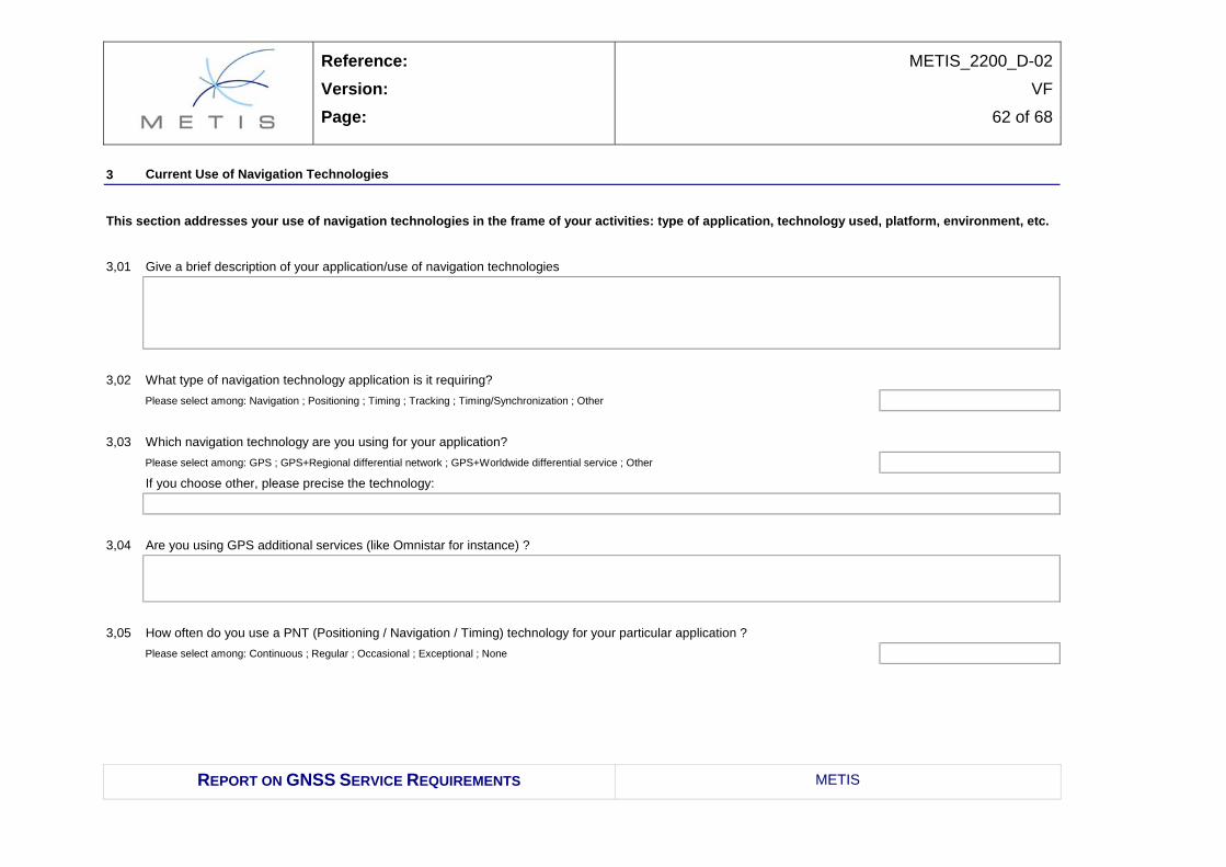
3 USERS’ NEEDS QUESTIONNAIRE
3.1 QUESTIONNAIRE CONTENT The initial task consists in setting up a questionnaire aimed at gathering the current use of GNSS technologies in the MEDA region and assessing the user’s expectations regarding the deployment of EGNOS and Galileo. The answers to this questionnaire feed a database related to
• Technical Performance Expected from future Systems
• Potential Service Enablers Availability at National or Regional level.
The questionnaire is given in full text in Annex 1.
3.2 DISSEMINATION AND ANSWERS TO THE QUESTIONNAIRE As a first step, the questionnaire has been sent to around 90 persons registered in the METIS Contact list. Up to that point (23rd April 2007) 23 answers were collected, mostly for aviation domain. Questionnaires have also been sent to the participants (20 persons) of the METIS Cairo Training and Awareness event in October 2007. At that point, only one additional answer was received (December 5th 2007). To improve the results collected about GNSS User Needs, the questionnaire has been sent a second time to the PoCs identified in the updated METIS Contact List end of January 2008 (the list was including 280 POCs). Two additional answers were received. The feedback gained during workshops and training sessions also contributed to the update of the present report.
3.3 OVERVIEW OF COLLECTED DATA A preliminary analysis of the collected data (26 answers) is given in this section. The results have been grouped under 4 groups: Countries and organisations, application and host platforms, use and environment of PNT technologies, performance requirements. The following figures detail these results.
Reference: Version: Page:
METIS_2200_D-02
VF
15 of 68
REPORT ON GNSS SERVICE REQUIREMENTS METIS
3.3.1 Countries and Organisation All MEDA countries but Israel answered to the questionnaires. One questionnaire from Palestinian Authority provided only contact data with no answer to the technical questions. The received answers are partitioned as shown in the next figure:
The organisations mainly involved were mainly Service Provider and Public Authorities. Institutional bodies are mainly governmental organisms like universities, national research laboratories or institutions that do not regulate nor provide any service. Public Authorities are governmental bodies or agencies in charge of the administration of public services like civil aviation, ports, roads and transport etc. Regulators are the governmental services, mainly at ministerial level, that are in charge to elaborate the laws and regulation in their domains.
3.3.2 Application and host platforms The most used navigation applications are Navigation and Positioning, with little interest for Timing and Tracking.
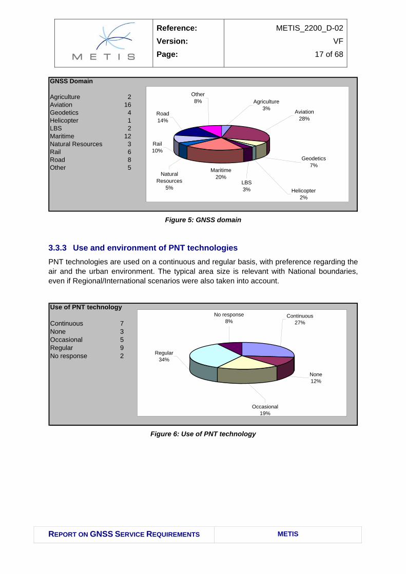
With regard to the host platform of the PNT equipment and the GNSS domain, more heterogeneous answers were available due to the possibility to choose one or more items from a predetermined list. Looking at the graphs it is clear how aviation is the most used domain for GNSS application, followed by both maritime and road/car.
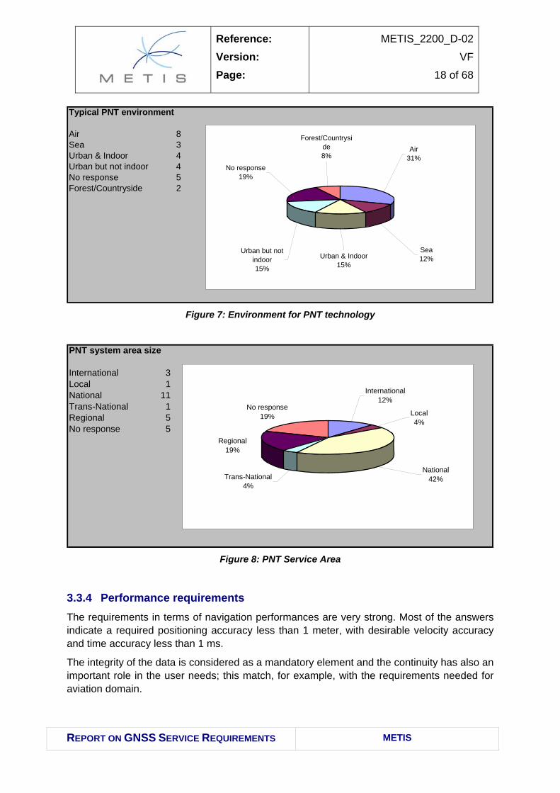
3.3.3 Use and environment of PNT technologies PNT technologies are used on a continuous and regular basis, with preference regarding the air and the urban environment. The typical area size is relevant with National boundaries, even if Regional/International scenarios were also taken into account.
Air 8Sea 3Urban & Indoor 4Urban but not indoor 4No response 5Forest/Countryside 2
Forest/Countryside8%
Air31%
Sea12%Urban & Indoor
15%
Urban but not indoor15%
No response19%
Figure 7: Environment for PNT technology
PNT system area size
International 3Local 1National 11Trans-National 1Regional 5No response 5
No response19%
International12%
Local4%
National42%
Regional19%
Trans-National4%
Figure 8: PNT Service Area
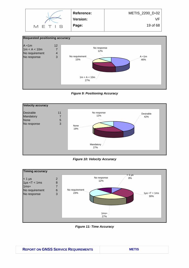
3.3.4 Performance requirements The requirements in terms of navigation performances are very strong. Most of the answers indicate a required positioning accuracy less than 1 meter, with desirable velocity accuracy and time accuracy less than 1 ms.
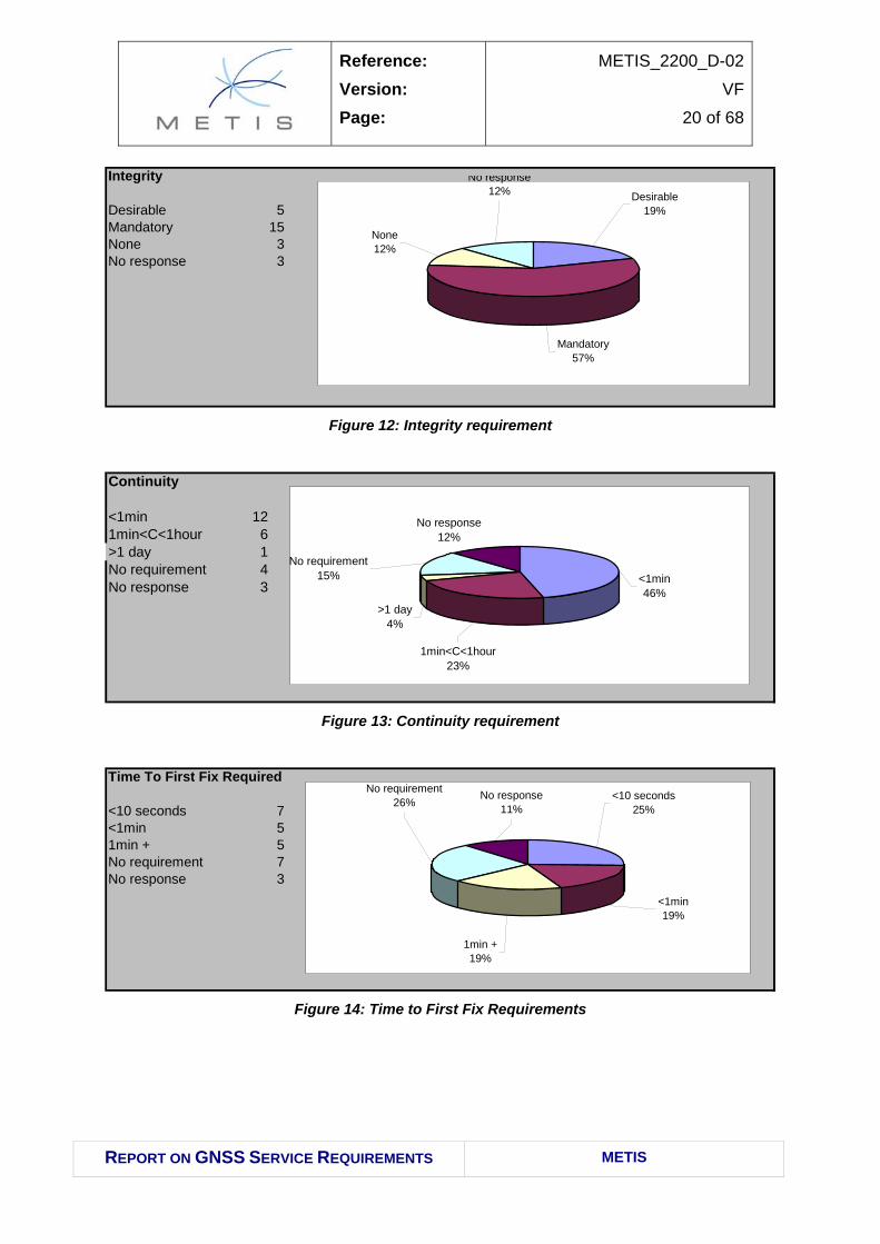
The integrity of the data is considered as a mandatory element and the continuity has also an important role in the user needs; this match, for example, with the requirements needed for aviation domain.
Reference: Version: Page:
METIS_2200_D-02
VF
19 of 68
REPORT ON GNSS SERVICE REQUIREMENTS METIS
Requested positioning accuracy
A <1m 121m < A < 10m 7No requirement 4No response 3 A <1m
3.4.1 Gaps Despite efforts undertaken to improve the number and quality of responses to the questionnaire disseminated, a number of gaps are still identified:
• Number of answers: the collected answers (25) represent less than 10% of the questionnaires sent.
• Countries: some one country’s feedback is missing or still poor regarding the scope of applications (e.g. Israel or Palestinian authority).
• Completeness of answers: many items are often not filled, particularly those related to national or regional plans or policies. Some domains (agriculture, natural resources, LBS) are insufficiently represented to get valid conclusions.
• Internal consistency of the answers: it has been noted that some answered items were not in line with some others, particularly between the description of the responsibilities devoted to the organism who answered and the GNSS domain, hosting platforms or navigation applications declared.
Reference: Version: Page:
METIS_2200_D-02
VF
22 of 68
REPORT ON GNSS SERVICE REQUIREMENTS METIS
4 ANALYSIS – REGIONAL SPECIFICITIES For consistency with the work performed under WP 2300 Regional Plan, the reporting of the results has been sorted by major application domains: civil aviation, maritime, rail, road, public safety-security. This presentation is deemed to be easier for the decision makers when studying the GNSS regional Plan.
4.1 CIVIL AVIATION
4.1.1 Available plan and regulations The Euro-Mediterranean region is characterised by the presence of investment coming from European, African and Middle-East stakeholders. The development of GNSS in aviation in MEDA is based on specific activities in addition to the GNSS general ones like the European GNSS strategy, the EU development policy and the Euro-Mediterranean partnership.
The European key actors in GNSS development are the European Commission (the two Directorates General “Energy & Transport” and “Europe Aid Co-operation Office”), the European Space Agency, the Galileo Supervisory Authority, the European Investment Bank, and bilateral stakeholders such as the EOIG (EGNOS Operators and Infrastructure Group).
On the MEDA side, there is the Euro-MED Transport Office, and in addition some of the MEDA countries are also part of other organisation (like Egypt in COMESA)
4.1.1.1 MEDA countries in civil aviation institutions
The stakeholders for the aviation activities are ICAO and IATA, at an International level, and the Air Traffic Service Providers, airlines, aircraft operators at the national level. Some MEDA countries are also belonging to the Arab Civil Aviation Commission who is an international body set up by the Arab League.
Regarding ICAO, MEDA Countries belongs to different ICAO Regions and planning groups as reported in the following table:
Civil Aviation Conference / Commission
Planning and Implementation Regional
Group MEDA Countries
ECAC ACAC MIDANPIRG APIRG Algeria X X Cyprus X Egypt X X X Israel X Jordan X X Lebanon X X
Reference: Version: Page:
METIS_2200_D-02
VF
23 of 68
REPORT ON GNSS SERVICE REQUIREMENTS METIS
Civil Aviation Conference / Commission
Planning and Implementation Regional
Group MEDA Countries
ECAC ACAC MIDANPIRG APIRG Malta X Morocco X X Palestine X Syria X X Tunisia X X Turkey X
Table 3: MEDA Countries in Civil Aviation Institutions
• European region: Turkey who is Member State of the ECAC and of Eurocontrol;
• Middle East region (MID): Egypt, Jordan, Israel, Lebanon, Syria,
• African and Indian Ocean region (AFI): Algeria, Tunisia, Egypt.
The Aviation ICAO GNSS policy has been progressing with regular meeting related to such regions.
The ICAO AFI (African and Indian Ocean) and MIDAN (Middle East Air Navigation) Planning and Implementation Regional Group (APIRG and MIDANPIRG) meetings enable Civil Aviation managers to exchange information, highlight progress in infrastructure development, traffic management, efficiency of operations, safety, and to access deficiencies, on a continental basis. As some of the MEDA countries belong to the AFI or MID Region, and that conclusions also affect their policies.
The 9th ICAO MIDANPIRG meeting has been held in Cairo (Egypt) between April 11th and 15th 2005. The conclusions 9/33 to 9/35, related to the activities, studies, demonstrations and Cost-Benefits analysis for the augmentation in the MID region where further discussed during the following 5th meeting of the ICAO Middle East GNSS Task Force (GNSS TF/5) where the existence of the MEDA infrastructure development was acknowledged and further cost and funding scheme analysis have been asked for covering the whole Middle East Region.
The conclusion 9/36 of the meeting MIDANPIRG/9 asked for the updated of the strategy for the GNSS implementation in the MID region taking into account users requirements and the outcome of the 11th Air Navigation Conference; in the GNSS TF/5 it was updated as in the following table.
Precision Approach ILS based ILS based CAT-I (augmented GNSS)CAT-II / III (ILS, GBAS1)
Decommissioning NDBs started NDBs completed VORs started
VORs completed ILS CAT-I
1 where operationally required and economically beneficial.
Table 4: MID GNSS Strategy
4.1.1.2 The AFI GNSS Strategy (APIRG)
The last 15th ICAO APIRG meeting has been held in Nairobi (Kenya) between September 26th and 30th 2005. Such meeting updated the AFI GNSS strategy developed by the AFI GNSS Working Group in the following three phases, the first of them considered closed.
AFI GNSS Strategy
Phase I Phase II Phase III Timescale
2000-2005 2006-2011 2012-2017
Certification Basic GNSS / NPA En-route to LPV (APV-I) En-route to CAT-I
Approach and Landing GPS/Baro NPA LPV (APV-I) SBAS CAT-I SBAS
CAT-I/II/III GBAS
Table 5: AFI GNSS Strategy up to 2017
4.1.1.3 The EU strategy
The EU Development policy under the European Commission Transport policy strategy has led to the cooperation between the European and MEDA entities. On this regard, the conclusion of the Euro-Mediterranean Ministerial Conference on Transport held in Marrakech on 15th December 2005, identified the need of cooperation between European and MEDA entities to cover issues related to the opening of the market and the promotion of regulatory convergence and technical cooperation on safety, security and ATM issues.
Actions has been identified for this purpose, like the extension of the applicability of Single European Sky regulations to the Mediterranean partners; the promotion of the role of the European Aviation Safety Agency (EASA) in view of potential cooperation. The long term objective identified is the definition of a Euro-Med Common Aviation Area.
Reference: Version: Page:
METIS_2200_D-02
VF
25 of 68
REPORT ON GNSS SERVICE REQUIREMENTS METIS
In line with the above objectives, a Euro-Mediterranean Aviation project is going to start in 2007, with the main tasks of:
• promoting approximation of the MEDA countries aviation regulations to the EU SES ones, providing technical assistance for this purpose;
• improving air safety and security in the region;
• promoting the cooperation on Air Traffic Management (ATM)
4.1.1.4 Bilateral agreements of interest
At present, bilateral relationships are in place between the European and MEDA aviation partners. Important example is the AEFMP group (composed by Civil Aviation Authorities and/or Air Navigation Services Providers of Algeria, Spain, France, Morocco and Portugal), created in the 1991 with the aim of harmonise the actions required to improve and harmonise the traffic flow in the air-space under the responsibility of the member states (the composition of the air-spaces is shown in the following figure). The AEFMP has defined a convergence plan for the harmonisation of the Air Navigation System.
Figure 15: AEFMP Airspace
As stated, air traffic exchanges between MEDA countries, as well as between these countries and other countries, including EU countries, are largely governed by traditional bilateral air services agreements. Nevertheless, MEDA countries have started to open international air traffic exchanges and to implement an open market policy. (cf. [AD5.])
Cyprus and Malta have already achieved such opening up of the markets with the EU, since they are EU member states and the SES regulations are directly applicable to such states.
Reference: Version: Page:
METIS_2200_D-02
VF
26 of 68
REPORT ON GNSS SERVICE REQUIREMENTS METIS
4.1.1.5 The Arab Civil Aviation Commission (ACAC)
Concerning the opening up of air transport exchanges among MEDA countries themselves, a significant initiative already exists in this domain, namely the ACAC programme (Arab Civil Aviation Commission programme for air transport liberalisation), which brings together eight MEDA countries (Lebanon, Syria, Jordan, Palestine, Egypt, Tunisia, Morocco and Algeria.) and is expected to be in full force by 2007. The Yamoussoukro Declaration which aims at opening up air transport exchanges across the entire African continent also presents another relevant initiative in this field (Algeria and Tunisia are members of this agreement and Morocco may join in the future). In addition, Morocco, Jordan, Israel and Algeria have negotiated bilateral open market agreements with the United States (Algeria is in the final stages of negotiation). The concrete benefits of these initiatives are already starting to appear.
Since May 2005, in agreement with the EC, ACAC allows its members to negotiate horizontal agreements with the EC. This decision is expected to give momentum to the ACAC members to start horizontal negotiations with the EC: Lebanon and Morocco have recently initialled a horizontal agreement with the EC in order to put existing bilateral air services agreements in conformity with Community law (EC has the mandate to negotiate such agreement with all third countries). Jordan has also recently completed the first round of negotiations with the EC in this regard and is expected to sign the horizontal agreement in the near future. The conclusion of such horizontal agreements is a prerequisite to any further cooperation with the EU in the aviation sector.
As far as negotiations for a global aviation agreement are concerned (vertical mandate), the only MEDA country for which the EC has a mandate at the present time is Morocco, with negotiations ongoing since May 2005. Such negotiations of a Euro-Mediterranean Aviation Agreement with Morocco will be a precedent for all future Euro-Mediterranean Aviation Agreements. In the light of the experience with Morocco, the EU Council of Ministers will decide on the Commission’s request to open similar aviation negotiations with Lebanon and Jordan.
4.1.2 User needs Answers to the questionnaire have been received only by civil aviation authorities, air navigation service providers and ATM related companies belonging to Egypt, Morocco, Lebanon, Jordan, Syria and the Palestinian Authority. In line with the high regulated nature of the civil aviation domain, the answers received are quite homogenous for what concerns the user needs, corresponding to the performances required for the different en-route, terminal and approach operations as indicated in the ICAO GNSS SARPS Annex 10 Vol. I.
Such requirements present some range of values for some of the performance parameters (availability and continuity) to be fixed according with the operational needs specific of the area of operations. For the EGNOS case such requirements have been fixed for Europe by Eurocontrol and, included in the EGNOS MRD v.2.0, they are considered applicable also to the MEDA region.
Reference: Version: Page:
METIS_2200_D-02
VF
27 of 68
REPORT ON GNSS SERVICE REQUIREMENTS METIS
For what concerns Galileo, two services have been defined in the Galileo MRD v6.0 to support the Civil Aviation users. They are the Galileo Open Service and the Galileo Safety of Life.
4.1.3 Use of GNSS
4.1.3.1 Aviation market segmentation
Aviation market is usually segmented in the following categories:
• Air Transport (AT): aircraft used in trade environment, and carrying passengers or goods (cargo);
• General Aviation (GA): all the other aircrafts used for leisure or commercial purposes, like: leisure, business aviation, air ambulances, training, aerial survey, and so on…
• Military and State aircraft; • Rotorcraft
4.1.3.2 Peculiarities of MEDA aviation market
Main peculiarities of the MEDA aviation market respect European structure can be summarised as below:
• Not complete coverage of the MEDA airspace by the existing ground Nav-Aids;
• Reliability of ground based Nav-Aids due to environmental, security and maintenance issues;
• Sustainability of the operational costs of the existing ground Nav-Aids; • High growth of cities dimension which reduces space for airports infrastructure
extension and highlight the need for flexibility in the design of the procedures;
• Age of the air-fleet, considering the traffic towards other African countries and the lack of tools like the European black-list for airlines.
4.1.3.3 GNSS Applications for aviation
GNSS applications for aviation can be generally listed as follows:
• Navigation in Oceanic and Remote airspaces; • En-route navigation in continental airspaces; • Terminal Airspaces; • Non Precision Approach (NPA) and Approach with Vertical Guidance (APV);
• Precision Approach and Landing; • Surface Movement (including A-SMGCS); • Automatic Dependent Surveillance (ADS);
Reference: Version: Page:
METIS_2200_D-02
VF
28 of 68
REPORT ON GNSS SERVICE REQUIREMENTS METIS
• Data Communication synchronization. • GPS Status monitoring
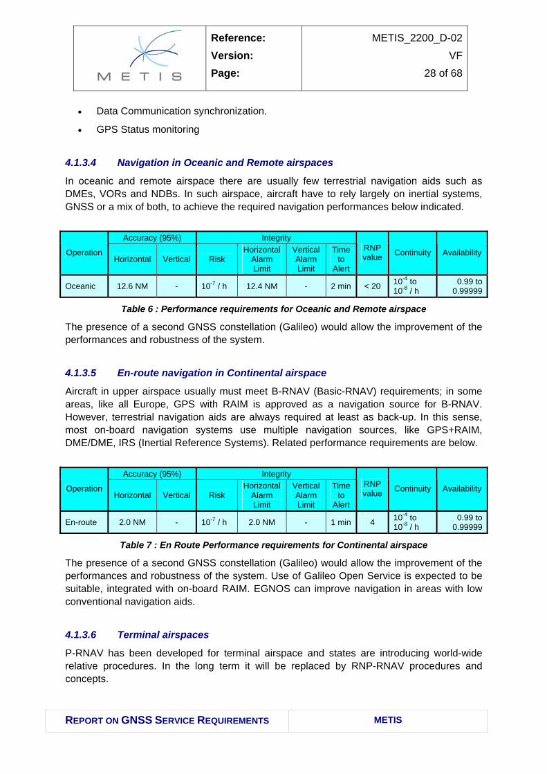
4.1.3.4 Navigation in Oceanic and Remote airspaces
In oceanic and remote airspace there are usually few terrestrial navigation aids such as DMEs, VORs and NDBs. In such airspace, aircraft have to rely largely on inertial systems, GNSS or a mix of both, to achieve the required navigation performances below indicated.
Accuracy (95%) Integrity
Operation Horizontal Vertical Risk
Horizontal Alarm Limit
Vertical Alarm Limit
Time to
Alert
RNP value Continuity Availability
Oceanic 12.6 NM - 10-7 / h 12.4 NM - 2 min < 20 10-4 to 10-8 / h
0.99 to 0.99999
Table 6 : Performance requirements for Oceanic and Remote airspace
The presence of a second GNSS constellation (Galileo) would allow the improvement of the performances and robustness of the system.
4.1.3.5 En-route navigation in Continental airspace
Aircraft in upper airspace usually must meet B-RNAV (Basic-RNAV) requirements; in some areas, like all Europe, GPS with RAIM is approved as a navigation source for B-RNAV. However, terrestrial navigation aids are always required at least as back-up. In this sense, most on-board navigation systems use multiple navigation sources, like GPS+RAIM, DME/DME, IRS (Inertial Reference Systems). Related performance requirements are below.
Accuracy (95%) Integrity
Operation Horizontal Vertical Risk
Horizontal Alarm Limit
Vertical Alarm Limit
Time to
Alert
RNP value Continuity Availability
En-route 2.0 NM - 10-7 / h 2.0 NM - 1 min 4 10-4 to 10-8 / h
0.99 to 0.99999
Table 7 : En Route Performance requirements for Continental airspace
The presence of a second GNSS constellation (Galileo) would allow the improvement of the performances and robustness of the system. Use of Galileo Open Service is expected to be suitable, integrated with on-board RAIM. EGNOS can improve navigation in areas with low conventional navigation aids.
4.1.3.6 Terminal airspaces
P-RNAV has been developed for terminal airspace and states are introducing world-wide relative procedures. In the long term it will be replaced by RNP-RNAV procedures and concepts.
Reference: Version: Page:
METIS_2200_D-02
VF
29 of 68
REPORT ON GNSS SERVICE REQUIREMENTS METIS
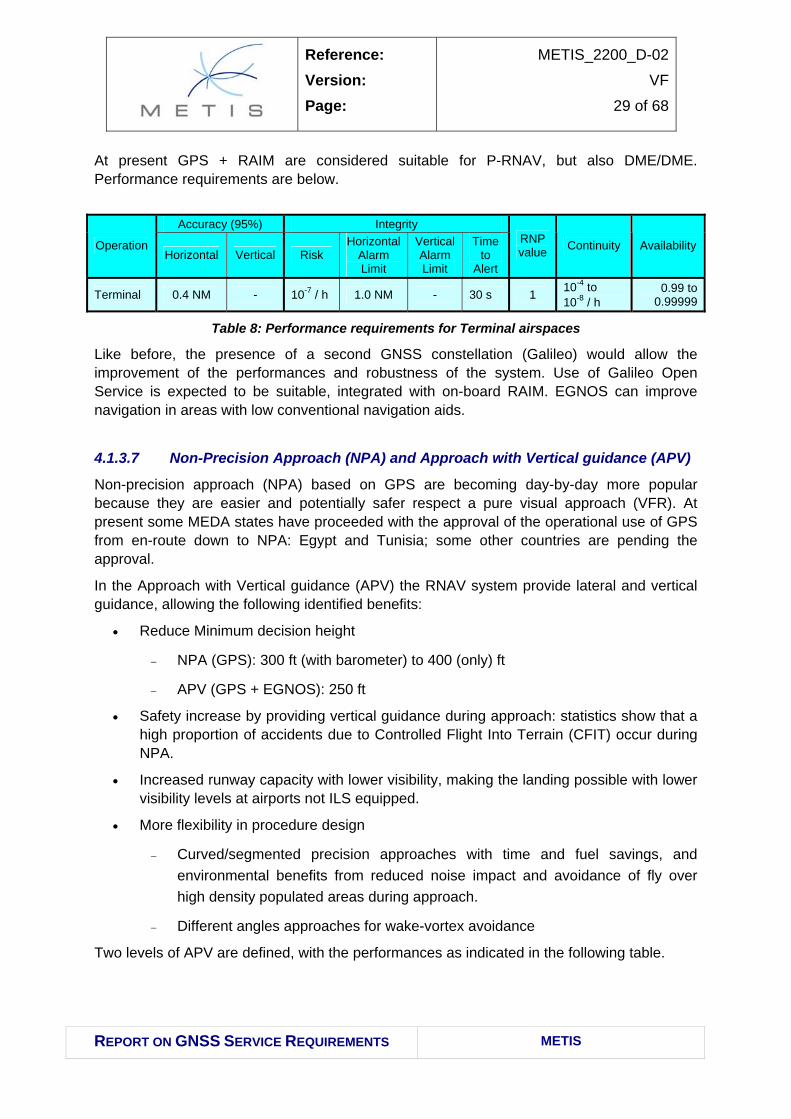
At present GPS + RAIM are considered suitable for P-RNAV, but also DME/DME. Performance requirements are below.
Accuracy (95%) Integrity
Operation Horizontal Vertical Risk
Horizontal Alarm Limit
Vertical Alarm Limit
Time to
Alert
RNP value Continuity Availability
Terminal 0.4 NM - 10-7 / h 1.0 NM - 30 s 1 10-4 to 10-8 / h
0.99 to 0.99999
Table 8: Performance requirements for Terminal airspaces
Like before, the presence of a second GNSS constellation (Galileo) would allow the improvement of the performances and robustness of the system. Use of Galileo Open Service is expected to be suitable, integrated with on-board RAIM. EGNOS can improve navigation in areas with low conventional navigation aids.
4.1.3.7 Non-Precision Approach (NPA) and Approach with Vertical guidance (APV)
Non-precision approach (NPA) based on GPS are becoming day-by-day more popular because they are easier and potentially safer respect a pure visual approach (VFR). At present some MEDA states have proceeded with the approval of the operational use of GPS from en-route down to NPA: Egypt and Tunisia; some other countries are pending the approval.
In the Approach with Vertical guidance (APV) the RNAV system provide lateral and vertical guidance, allowing the following identified benefits:
• Reduce Minimum decision height
− NPA (GPS): 300 ft (with barometer) to 400 (only) ft
− APV (GPS + EGNOS): 250 ft
• Safety increase by providing vertical guidance during approach: statistics show that a high proportion of accidents due to Controlled Flight Into Terrain (CFIT) occur during NPA.
• Increased runway capacity with lower visibility, making the landing possible with lower visibility levels at airports not ILS equipped.
• More flexibility in procedure design
− Curved/segmented precision approaches with time and fuel savings, and environmental benefits from reduced noise impact and avoidance of fly over high density populated areas during approach.
− Different angles approaches for wake-vortex avoidance
Two levels of APV are defined, with the performances as indicated in the following table.
Reference: Version: Page:
METIS_2200_D-02
VF
30 of 68
REPORT ON GNSS SERVICE REQUIREMENTS METIS
Accuracy (95%) Integrity
Operation Horizontal Vertical Risk
Horizontal Alarm Limit
Vertical Alarm Limit
Time to
Alert
RNP value Continuity Availability
NPA 220 m - 10-7 / h 556 m - 10 s 0.3 10-4 to 10-8 / h
0.99 to 0.99999
APV-I 16 m 20 m 2x10⁻⁷ / approach 40 m 50 m 10 s 0.3/125 8x10⁻⁶ in
any 15s 0.99 to
0.99999
APV-II 16 m 8 m 2x10⁻⁷ / approach 40 m 20 m 6 s 0.03/50 8x10⁻⁶ in
any 15s 0.99 to
0.99999
Table 9: Performance requirements for NPA and APV approaches
APV approaches have been designed to be supported by GNSS, mainly by SBAS; at present some high capability aircraft are near to fly APV-I independently from the presence of external GPS augmentation.
Other aircraft are locally authorised (in different countries) to fly procedures with intermediate performances (in terms of minima) between NPA and APV, by relying on Baro-VNAV. Discussions are on-going in aviation operational environments about operational and safety issues related to such operation.
As reported in the EGNOS MRD v.2.0, EGNOS is going to provide NPA over MEDA FIRs and APV-I over MEDA landmasses, and will be able to provide APV-II and CAT-I when the modernised GPS (with the double civil frequency L1/L5) and Galileo will be available.
Regarding Galileo, at present the MRD assign Galileo Safety of Life (SoL) service the mission to provide APV-II world-wide alone. This would allow having more robust RNAV systems based on GPS+SBAS and Galileo SoL services.
4.1.3.8 Precision Approach and Landing (PA)
Instrument Landing System (ILS) is used since 50 years for precision approach and landing and offers CAT-I, II and III capability. Most of the large aircraft world-wide are basically equipped with ILS, and almost all the main airports world-wide are equipped with ILS on at least one runway. The system requires maintenance and could present outage periods.
Recently Microwave Landing System (MLS) and GBAS are under development (GBAS) and initial installation and will provide the required performances below.
Accuracy (95%) Integrity
Operation Horizontal Vertical Risk
Horizontal Alarm Limit
Vertical Alarm Limit
Time to
Alert
RNP value Continuity Availability
CAT – I 16 m 4 to 6 m
2x10⁻⁷ / approach 40 m 10 to
15 m 6 s 0.02/40 10-6 / 15s 0.99 to 0.99999
CAT – II 6.9 m 2 m 2x10⁻⁹ / 15s 17.3 m 5.3 m 1 s 0.01/15 4x10⁻⁶ in
any 15s 0.99 to
0.99999
CAT – III 6.2 m 2 m 2x10⁻⁹ / 15s 15.5 m 5.3 m 1 s 0.003/z 4x10⁻⁶ in
any 15s 0.99 to
0.99999
Table 10: Performance requirements for Precision Approach
Reference: Version: Page:
METIS_2200_D-02
VF
31 of 68
REPORT ON GNSS SERVICE REQUIREMENTS METIS
GBAS for CAT-I is under initial pilot installation in Europe and Australia; for CAT-II / III capabilities it is probably required to wait until the additional capabilities in terms of double frequency and robustness will be available from Galileo and the modernised GPS. Studies are on progress through FAA and Eurocontrol for harmonisation of the RTCA and Eurocae standardisation.
4.1.3.9 Surface Movement
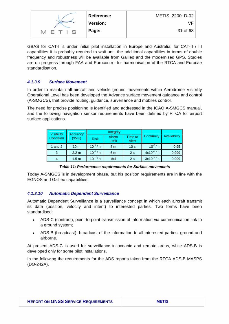
In order to maintain all aircraft and vehicle ground movements within Aerodrome Visibility Operational Level has been developed the Advance surface movement guidance and control (A-SMGCS), that provide routing, guidance, surveillance and mobiles control.
The need for precise positioning is identified and addressed in the ICAO A-SMGCS manual, and the following navigation sensor requirements have been defined by RTCA for airport surface applications.
Integrity Visibility
Condition Accuracy
(95%) Risk Alarm Limit
Time to Alert
Continuity Availability
1 and 2 10 m 10-5 / h 8 m 10 s 10-3 / h 0.95
3 2.2 m 10-6 / h 6 m 2 s 4x10⁻⁴ / h 0.999
4 1.5 m 10-7 / h tbd 2 s 3x10⁻³ / h 0.999
Table 11: Performance requirements for Surface movements
Today A-SMGCS is in development phase, but his position requirements are in line with the EGNOS and Galileo capabilities.
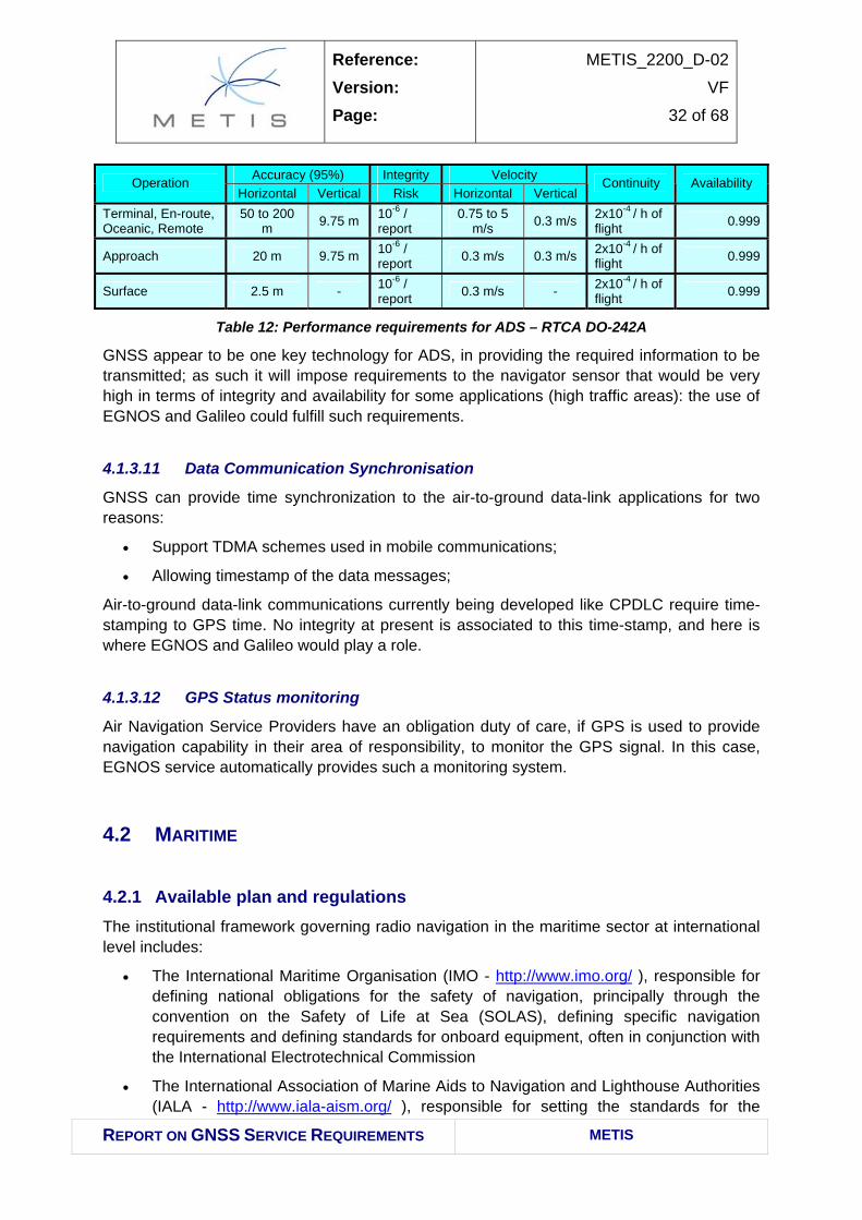
4.1.3.10 Automatic Dependent Surveillance
Automatic Dependent Surveillance is a surveillance concept in which each aircraft transmit its data (position, velocity and intent) to interested parties. Two forms have been standardised:
• ADS-C (contract), point-to-point transmission of information via communication link to a ground system;
• ADS-B (broadcast), broadcast of the information to all interested parties, ground and airborne.
At present ADS-C is used for surveillance in oceanic and remote areas, while ADS-B is developed only for some pilot installations.
In the following the requirements for the ADS reports taken from the RTCA ADS-B MASPS (DO-242A).
Approach 20 m 9.75 m 10-6 / report 0.3 m/s 0.3 m/s 2x10⁻⁴ / h of
flight 0.999
Surface 2.5 m - 10-6 / report 0.3 m/s - 2x10⁻⁴ / h of
flight 0.999
Table 12: Performance requirements for ADS – RTCA DO-242A
GNSS appear to be one key technology for ADS, in providing the required information to be transmitted; as such it will impose requirements to the navigator sensor that would be very high in terms of integrity and availability for some applications (high traffic areas): the use of EGNOS and Galileo could fulfill such requirements.
4.1.3.11 Data Communication Synchronisation
GNSS can provide time synchronization to the air-to-ground data-link applications for two reasons:
• Support TDMA schemes used in mobile communications;
• Allowing timestamp of the data messages;
Air-to-ground data-link communications currently being developed like CPDLC require time-stamping to GPS time. No integrity at present is associated to this time-stamp, and here is where EGNOS and Galileo would play a role.
4.1.3.12 GPS Status monitoring
Air Navigation Service Providers have an obligation duty of care, if GPS is used to provide navigation capability in their area of responsibility, to monitor the GPS signal. In this case, EGNOS service automatically provides such a monitoring system.
4.2 MARITIME
4.2.1 Available plan and regulations The institutional framework governing radio navigation in the maritime sector at international level includes:
• The International Maritime Organisation (IMO - http://www.imo.org/ ), responsible for defining national obligations for the safety of navigation, principally through the convention on the Safety of Life at Sea (SOLAS), defining specific navigation requirements and defining standards for onboard equipment, often in conjunction with the International Electrotechnical Commission
• The International Association of Marine Aids to Navigation and Lighthouse Authorities (IALA - http://www.iala-aism.org/ ), responsible for setting the standards for the
Reference: Version: Page:
METIS_2200_D-02
VF
33 of 68
REPORT ON GNSS SERVICE REQUIREMENTS METIS
provision of marine radio-navigation services and initiating the definition of signal-in-space standards, principally through the International Telecommunications Union (ITU) and the Radio Technical Commission Maritime (RTCM).
All MEDA countries are members of the International Maritime Organisation and have adopted the basic IMO conventions relating to maritime safety, security and environmental protection; the only MEDA countries members of IALA are Algeria, Morocco, Egypt, Tunisia.
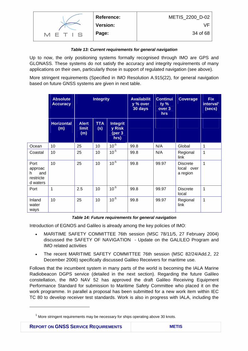
The current requirements for general navigation are specified in IMO Resolution A.953(23) on the World-Wide Radio Navigation System (WWRNS). These requirements are applicable to current systems, and are considerably less stringent than those specified for future GNSS systems. The current requirements are specified for navigation in harbour entrances, harbour approaches and coastal waters (i.e. discrete, local coverage is required) with a high volume of traffic and/or significant degree of risk:
• Accuracy should be better than 10 m to 95% probability
• Coverage should be adequate throughout the phase of navigation
• Signal availability should be 99.8% over a two-year period
• The update rate should be better than once every 10 s (every 2 s if the position data is used for AIS, graphical display or to control the vessel directly)
• The service reliability (undefined) should be better than 99.97% per over a 3 hour period
• The time-to-alarm for non-availability or discontinuity should be better than 10 seconds.
Current requirements (Specified in IMO Resolution A.953(23) for general navigation are given in next table. These are applicable to current systems such as GPS and the IALA radiobeacon DGPS service.
Accuracy (95%)
Horizontal (m)
TTA (s) Availability % over 2
yrs
Reliability % over
3 hrs
Coverage Update rate
(secs)
Ocean waters 100 Asap by MSI
99.8 over 30 days
10
Coastal waters, harbour entrances, approaches – high volume /signf. risk
Table 13: Current requirements for general navigation
Up to now, the only positioning systems formally recognised through IMO are GPS and GLONASS. These systems do not satisfy the accuracy and integrity requirements of many applications on their own, particularly those in support of regulated navigation (see above).
More stringent requirements (Specified in IMO Resolution A.915(22), for general navigation based on future GNSS systems are given in next table.
10 25 10 10-5 99.8 99.97 Discrete local over a region
1
Port 1 2.5 10 10-5 99.8 99.97 Discrete local
1
Inland water ways
10 25 10 10-5 99.8 99.97 Regional link
1
Table 14: Future requirements for general navigation
Introduction of EGNOS and Galileo is already among the key policies of IMO:
• MARITIME SAFETY COMMITTEE 76th session (MSC 78/11/5, 27 February 2004) discussed the SAFETY OF NAVIGATION - Update on the GALILEO Program and IMO related activities
• The recent MARITIME SAFETY COMMITTEE 76th session (MSC 82/24/Add.2, 22 December 2006) specifically discussed Galileo Receivers for maritime use.
Follows that the incumbent system in many parts of the world is becoming the IALA Marine Radiobeacon DGPS service (detailed in the next section). Regarding the future Galileo constellation, the IMO NAV 52 has approved the draft Galileo Receiving Equipment Performance Standard for submission to Maritime Safety Committee who placed it on the work programme. In parallel a proposal has been submitted for a new work item within IEC TC 80 to develop receiver test standards. Work is also in progress with IALA, including the
1 More stringent requirements may be necessary for ships operating above 30 knots.
Reference: Version: Page:
METIS_2200_D-02
VF
35 of 68
REPORT ON GNSS SERVICE REQUIREMENTS METIS
review of the IALA NAVGUIDE and IALA R-121 recommendation, to ensure Galileo is included. This work is carried out in the new e-NAV committee resulting from the merge of the former AIS and RNAV committees.
With respect to the issue of maritime security, it seems that the level to which the IMO’s International Ship and Port Facility Security Code (ISPS Code) is implemented differs greatly among MEDA countries, although there is common acceptance of its provisions and necessity. Most ports are still gathering the necessary capacity and funds to fully deploy the required security and contingency plans. Regarding security on board vessels, the provisions of the ISPS Code for on-board security are mandatory for ships registered in MEDA countries. However, as such regulations are fairly recent, their implementation by ship-owners is often not complete.
In the frame of Euro-Mediterranean Ministerial Conference on Transport (Marrakech, 15 December 2005), it was recommended to support an enhanced role of the European Maritime Safety Agency (EMSA) in the Mediterranean region, including the possibility for Mediterranean Partners to participate as observers in EMSA activities.
The SAFEMED Project specifically focuses on maritime safety and security in the Mediterranean region. It is a response to the interest of the European Union (EU) to develop Euro-Mediterranean cooperation in the field of maritime safety and security and prevention of pollution from ships, by providing technical advice and support to the non-EU Mediterranean countries included in the group of “Mediterranean Partners” as defined in the Euro-Mediterranean Partnership established in the 1995 Barcelona Conference. The ten Mediterranean Partners are Algeria, Egypt, Israel, Jordan, Lebanon, Morocco, the Palestinian Authority, Syria, Tunisia, and Turkey
The project is being implemented since January 2006 and until the end of 2008, under the overall coordination of the European Commission and with technical backstopping from IMO.
4.2.2 User needs Due to the importance of maritime transport as the predominant mode of transport in the Mediterranean region, it is quite clear that the Mediterranean basin constitutes a priority area for the development of Motorway of the Sea (MoS) and for the enhancement of maritime trade.
This includes both the improvement of existing maritime links and the creation of new links, whether between the EU and the MEDA countries or between the MEDA countries themselves.
It should be noted that the development of the MoS concept in the Mediterranean region would be justified not on the basis of reducing road congestion (as this problem is not as common in the MEDA region as in the EU), but rather on the basis of the significant regional benefits that can be obtained including enhanced economic efficiency and environmental sustainability of the transport system, as well as increased regional cohesion promoted by the improved connections between the various shores and island states of the Mediterranean.
Reference: Version: Page:
METIS_2200_D-02
VF
36 of 68
REPORT ON GNSS SERVICE REQUIREMENTS METIS
Thus, the extension of the Motorways of the Sea to connect the European Union with the neighbouring regions, including the Mediterranean is a strategic issue from both MEDA and European viewpoint.
To implement the Motorways of the Sea concept in the MEDA region (as well is in other neighbouring regions of the EU), measures to improve the quality of infrastructure and services in ports, to ensure good connections from the ports to their hinterland but also to stimulate more frequent and reliable shipping services are essential. Good intermodal connections between ports and the road, rail and inland waterway networks are also necessary. Measures to improve maritime safety should also be looked at.
In addition, it should not be forgot the support to the short-range navigation, typically coastal, and the fisheries activities, one of the main economical activities around the Mediterranean sea, with safety, liability, environmental and security issue that can benefit from the availability of an improved and liable PVT information.
More in details, the following axes (in the Mediterranean region and of trans-national interest) are identified as issues of priority:
• The extension of the Mediterranean Motorways of the Sea to the Mediterranean neighbours;
• The multimodal axis connecting Turkey to Syria, Jordan up to Cairo/Alexandria (as part of the South-Eastern axis identified by the Group). In the longer term, extension of this multimodal axis to from Alexandria – Libya- up to Tunisian borders as well as a connection from Egypt to the South towards other African countries are also foreseen.
• Connections from the East Mediterranean countries towards, Iran and Iraq and the Persian Gulf are also foreseen in the longer term (the multimodal branch connecting Damietta to Cairo up to Aswut - including also inland waterways mode -, the axis from Haifa port to Amman towards Saudi Arabia, the axis from the port of Tartus to Damascus towards Iraq and the axis from the port of Beirut to Damascus);
• The multimodal axis connecting the Iberia Peninsula to Morocco up to Agadir (as part of the South-Western axis identified by the Group).
• The multimodal axis connecting Rabat to Alger, to Tunis up to Libyan borders.
• The general improvement of coastal navigation, supporting sort range navigation and fisheries activities.
Due to the geographical nature of the MEDA Countries, inland waterways navigation is not seen as a priority, of course excluding the Egypt, where the Nile is characterised by high traffic that involve both goods and passenger transport, highlighting safety issues that need to be carefully solved.
Similar safety environment, mixing passenger and goods transport, even if in a different environment, can be seen the navigation in strict waterways, like Bosporus and Suez Channel. Here the precise positioning of the vessel assume the highest importance, due to the nature of the transports and the high level of traffic, that push towards solutions able to increase both the efficiency without reducing, even better, improving, the safety levels.
Reference: Version: Page:
METIS_2200_D-02
VF
37 of 68
REPORT ON GNSS SERVICE REQUIREMENTS METIS
4.2.3 Use of GNSS The maritime market represents one of the most mature sets of GNSS users and already depends heavily upon GPS for today’s operational needs. Although not as heavily regulated as the aviation market, it is an international community which to that end, depends upon standards and regulatory measures for global interoperability and safety. The future steps necessary to support the introduction of EGNOS and Galileo are well known and documented and much work is already underway. It is generally expected that as these new GNSS services become available, the maritime community will make immediate use of the potential increase in overall performance.
Ocean: The principal use of navigation systems in this phase of the voyage is for the execution of safe and efficient routes, accounting for weather conditions.
Coastal: The principal uses of navigation systems in this phase of the voyage are associated with maintaining safety. At present, coastal navigation only requires two-dimensional position-fixing but this may be increased to three-dimensional in the future, depending on the depth of channels being navigated.
Port approaches: The need for frequent manoeuvring, close proximity to other vessels and grounding mean that navigation requirements are more stringent than for the coastal phase and may require three-dimensional position fixing, depending on local circumstances, e.g. whether channels are shallow compared to the draught of the vessel.
Transition from sea to river navigation: This type of navigation is not considered separately, as it has the same requirements as navigation as ports, port approaches and restricted waters.
Inland waterways: These requirements are generally governed by local or regional authorities, which may or may not adopt IMO recommendations. It has been assumed that IMO requirements are representative.
The requirements for radionavigation systems to support general navigation have been agreed globally within the IMO forum and are either requirements that are currently applicable or future requirements.
Inland waterways are used by mainly three types of vessels: cargo, passenger and leisure vessels. Cargo and passenger transportation gain an increasing importance on European rivers and call for modern and reliable tools to improve the service.
In particular for the transportation of goods, the inland mode of transport is typically part of a multimodal chain.
The integration of Information and Communication Technology (ICT) within the operational processes of the inland waterway sector has not been developed to the same level in relation to other transport modes. However, as a consequence of the possibilities and opportunities that are connected to ICT - increased efficiency of logistics operations, increased safety, improved environmental protection - so-called River Information Services (RIS) are undergoing development within regulation framework. These services are seen as a major step forward, turning inland navigation into a transparent, reliable, flexible, safe and easy-to-access transport mode. In addition to the significance of RIS for commercial logistics actors,
Reference: Version: Page:
METIS_2200_D-02
VF
38 of 68
REPORT ON GNSS SERVICE REQUIREMENTS METIS
RIS have proven to be invaluable for waterway authorities (e.g. supporting traffic management tasks, dangerous goods monitoring, Calamity abatement etc.).
Concerning inland waterways, in order to be a competitive mode of transport (in particular for goods), they shall not represent a ”stand-alone” in multimodality, but on the contrary shall be integrated in an effective intermodality chain.
Such integration can be pursued only by increasing efficiency, while ensuring safety.
GNSS-based technologies and services can help in the achievement of this objective. Hence, the main opportunities of GNSS for this market segment rely on GNSS’s capability to be an important instrument allowing the enhancement of inland waterways transportation. The introduction of GNSS use can support inland waterways in being a competitive means of transport, and in line with European policies concerning the development of sustainable transport systems
In the MEDA region, presently there is not a specific policy fostering implementation of RIS. However, the future planning of the use of GNSS in Egypt also includes DGPS and digital maps will be used for safe navigation in the River Nile.
4.2.3.1 Regulated marine navigation
Currently, radio-navigation plays a key role in maritime policy and plans for provision of aids to navigation at international level. For example, IMO has specified a requirement for all SOLAS vessels to carry a radio-navigation receiver (satellite or terrestrial) suitable for use at all times during its voyage.
By the use of this equipment, the current SOLAS convention mandates the use of the following:
• Automatic Identification System (AIS)
AIS is an autonomous and continuous broadcast system, operating in the VHF maritime mobile band. It is capable of exchanging information such as vessel identification, position, course, speed, etc through information broadcasts. The system can provide many benefits, including increased situational awareness, improved navigational safety and automatic reporting in areas of mandatory and voluntary reporting schemes.
• Voyage Data Recorders (VDR)
Like the black boxes carried on aircraft, VDRs enable accident investigators to review procedures and instructions in the moments before an incident and help to identify the cause of any accident.
VDRs must equip passenger ships and ships other than passenger ships of 3000 gross tonnage and upwards constructed on or after 1 July 2002 to assist in accident investigations, under regulations adopted in 2000, which entered into force on 1 July 2002.
The mandatory regulations are contained in chapter V on Safety of Navigation of the International Convention for the Safety of Life at Sea, 1974 (SOLAS).
• Vessel Traffic Services (VTS)
Reference: Version: Page:
METIS_2200_D-02
VF
39 of 68
REPORT ON GNSS SERVICE REQUIREMENTS METIS
Vessel traffic services are shore-side systems which range from the provision of simple information messages to ships, such as position of other traffic or meteorological hazard warnings, to extensive management of traffic within a port or waterway. SOLAS Chapter V (Safety of Navigation) states that governments may establish VTS when, in their opinion, the volume of traffic or the degree of risk justifies such services.
All of the above mentioned systems require or benefit from input from positioning systems.
In general terms, the maritime market sector is a mature user base of GPS with a relatively slow evolution expected over the next twenty years, characteristic of an internationally regulated marketplace. Key evolutionary factors are:
• Slow but steady growth in global vessel population, consistent with figures for global trade;
• Increasing concerns regarding issues of homeland security and further applications such as long-range identification and tracking (LRIT) likely;
• Demands for higher accuracy and integrity for ‘marginal’ port operations, resulting in specific local infrastructure and offering benefits in greater capacity and goods traffic;
• Increasing concerns regarding dependency upon GPS and levels of vulnerability, giving rise to need for complementary solutions.
4.2.3.2 Marine engineering
This application deals with high-precision positioning systems (as IALA Radio beacon DGNSS) to face with environments like channels and port areas with very stringent horizontal and vertical absolute accuracy requirements but with coverage confined to the specific areas of interest.
Other possible application could be cable and pipe lying, where coverage may be required over large areas. GPS and wide-area differential services may be used in this case. Real-time solutions (data exchange, precise survey and positioning etc.) could also be an important driver to enlarge this market.
4.2.3.3 Multimodal transhipment
Mediterranean Motorways of the Sea and short-sea-shipping are a priority for the Euro-Mediterranean transport network. The shared Euro-Mediterranean key policy objectives rely in the development of port hinterland connections and cooperation between ports in order to promote “motorways of the sea” projects, approximation of market conditions taking into consideration international and European standards, and progressive replacement of the numerous existing bilateral agreements by more comprehensive agreements at regional or sub-regional level; simplifying and harmonisation of border crossing procedures (in particular customs procedures).
The importance of intermodal container facilities at ports and inland shall be included among key policy objectives, since they become bottlenecks if not given the required attention.
Reference: Version: Page:
METIS_2200_D-02
VF
40 of 68
REPORT ON GNSS SERVICE REQUIREMENTS METIS
The border-crossing process is not optimally streamlined; customs practices are not simplified as should be, adherence to international agreements is not sufficient, and the level of development of the freight forwarding industry does not satisfactorily meet international standards.
4.2.3.4 Inland Waterways Navigation
River Information Services
River Information Services means the harmonised information services to support traffic and transport management in inland navigation, including interfaces to other transport modes. RIS aim at contributing to a safe and efficient transport process and utilizing the inland waterways to their fullest extent. RIS are already in operation in manifold ways.
Rivers in the context of RIS include all types of inland waterways, e.g. canals, lakes and ports, too: it regards the collection, processing, assessment and dissemination of fairway, traffic and transport information. It includes interfaces with other transport modes on sea, roads and railways.
4.3 RAIL
4.3.1 Available plan and regulations Available plans refer to the following organisations:
• ESCWA (United Nations Economic and Social Commission for Western Asia, www.escwa.org.lb/ The United Nations Economic and Social Commission for Western Asia (UNESCWA or ESCWA) was established in 1973 (then as the UN Economic Commission for Western Asia) to encourage economic cooperation among its member states. It is one of five regional commissions under the administrative direction of United Nations headquarters. The ESCWA has 13 member States, and reports to the UN Economic and Social Council (ECOSOC). Member States are: Bahrain, Egypt, Iraq, Jordan, Kuwait, Lebanon, Oman, Palestinian Authority, Qatar, Saudi Arabia, Syrian Arab Republic, United Arab Emirates, Yemen.
• AMU (Azione per Un Mondo Unito, http://www.azionemondounito.org/home.asp),
• UNECE (United Nations Economic Commission for Europe, http://www.unece.org/Welcome.html . The United Nations Economic Commission for Europe (UNECE) is one of the five regional commissions of the United Nations. It is the forum where the countries of western, central and eastern Europe, central Asia and North America – 56 countries in all – come together to forge the tools of their economic cooperation. That cooperation concerns such areas as economic cooperation and integration, energy, environment, human settlements, population, statistics, timber, trade, and transport.
Reference: Version: Page:
METIS_2200_D-02
VF
41 of 68
REPORT ON GNSS SERVICE REQUIREMENTS METIS
Standardisation/Regulations Framework includes the UIC (International Union of Railways, www.uic.asso.fr) the worldwide organisation for railway cooperation. It is active in all the fields involved in developing rail transport.
The harmonisation of international railway transport is given little attention by the MEDA countries at the time being. This is understandable given the fact that regional rail traffic is currently insignificant as strategic rail links between neighbouring countries are often missing, and in the occasions where such links do exist, their operation is sometimes disrupted due to political problems (e.g. closure of borders between Morocco and Algeria).
Accordingly, bilateral and multilateral rail transport agreements are rather limited in the region, in contrast to road transport. Moreover, many sub-regional initiatives pertaining to rail transport (e.g. ESCWA Agreement on International Railways, AMU Agreement on Rail Transport) are either not fully adopted by the member countries or not actually implemented.
As for the important UNECE rail conventions and the recommendations of the International Union of Railways (UIC), these have been adopted by few countries only (e.g. Syria implements the basic international rail conventions; Morocco is an active member of the UIC and applies all standards of this union; Turkey is also an active member of the UIC and adopts all relevant UIC standards concerning railway infrastructure, rolling stock and railway operations), and neglected by many others.
4.3.2 User needs In this sector, Railway Reform and Market Opening is the key element, driving the needs. Market opening and reform in the rail sector are the separation of infrastructure management from the commercial operations, and permitting the involvement of the private sector in the rail business. To this end, MEDA countries can be categorised into three groups:
• The first group includes Egypt, Syria, Tunisia and Lebanon which are at early stages of market reform, with a restricted administrative and financial independence of rail authorities, no legal framework to allow the involvement of the private sector in the rail business (except in Egypt and Syria where this is allowed), and no separation of infrastructure management from operations (except in Tunisia where within the rail authority, different units with different accounts are responsible for each function). It should be noted that all these countries are preparing plans in relation to the reform of their rail sectors; however, actual implementation seems to be still lacking.
• The second group consists of Jordan and Turkey which are at an intermediate stage in terms of market reform. A restructuring programme is underway for the Aqaba rail where infrastructure will remain under state ownership and operations will be concessioned to a public-private company responsible also for the construction of new lines. Similarly, in Turkey, a huge programme is ongoing with the aim of restructuring TCDD, separating infrastructure from operations, and dealing with the issue of subsidies coming from the port revenues (port revenues are not used in support of a single activity but rather to feed the overall budget of the rail sector which is prepared as a single annual budget). It should also be noted that in Turkey, the private sector is allowed to operate trains on certain lines sections under a legal framework that has been recently put into force.
Reference: Version: Page:
METIS_2200_D-02
VF
42 of 68
REPORT ON GNSS SERVICE REQUIREMENTS METIS
• The third group includes countries such as Morocco, Algeria and Israel which are at an advanced stage in this domain, with separation of infrastructure management from commercial operations being complete, although in different forms, and with a legal framework already in place allowing private sector participation in rail construction and/or operation (although very limited involvement of the private sector has been actually witnessed to this date).
The MEDA rail network that connects the various MEDA countries together is also highly disjointed due to the following reasons:
• Libya2 (even though Libya is not part of MEDA countries) has currently no operational rail system, and has recently abandoned its railway development programme
• No current connection exists between rail networks in Jordan, Israel, Egypt and Lebanon.
• A significant portion of the MEDA rail networks is non-interoperable due to differences in rail gauge. Specifically, narrow gauge rail tracks still exist in Jordan, Lebanon, Syria and Tunisia, although at varying extents and levels. As such, any major rail upgrading/reconstruction programme in these countries would require the standardisation of rail gauge, given a long-term view for the promotion of inter-MEDA and EU-MEDA rail services. There are, however, some recent improvements in this regard. Syria has started, within its own territory, the process of reconstruction of the Hijaz railway line to standard gauge. Jordan has initiated a Master Plan study for railways, through which the upgrading of the Hijaz line to standard gauge will be considered up to the Syrian borders. Lebanon will be constructing in the near future a standard gauge link between the port of Tripoli and Homs city in Syria.
• In some cases where interoperable cross-border rail links, in relatively good condition, do exist, political factors hinder the operation of these links.
• In addition, it is worth noting that some bottlenecks exist in the rail systems of Turkey and Egypt, mostly related to the lack of modern signalling systems and single-track operation.
4.3.3 Use of GNSS GNSS applications in the rail market can be divided into two distinct categories:
• Non-safety critical applications such as fleet and asset/freight management; passenger information; track survey;
• Safety critical: train control and supervision and derived applications such as energy optimised driving style manager.
In non-safety critical applications, the decisions to implement such systems are based on the individual choices of train operators and are driven simply by the local cost-benefit that they offer.
2 Libya is not part of MEDA countries
Reference: Version: Page:
METIS_2200_D-02
VF
43 of 68
REPORT ON GNSS SERVICE REQUIREMENTS METIS
The situation is much more complicated in safety critical applications, where international standards and local safety regulations are of critical significance.
The rail market represents today a very small market for GNSS. Train operating companies (Railway infrastructure managers, Railway Undertakings and Rail Transport Operators/Forwarders) can make use of GPS for the purposes of management (asset and freight) or passenger information.
Today’s safety critical and signalling systems depend primarily upon traditional track-based passive components to determine train location. Although international standards allow for the future location of trains independently from the ground infrastructure, this has yet to be embraced. It is however well understood that GNSS offers the potential benefit of significant savings in ground infrastructure provision and maintenance particularly for low traffic density rural lines
While in Europe, as awareness of new GNSS services increases, more and more train infrastructure providers are beginning to assess the potential through studies and demonstrations, MEDA region are still immature with respect to such issue (mainly to the fact that more modern infrastructures should be required, including rail tracks and communication).
Key GNSS applications are the localisation of locos and wagon, for freight and passengers. Concerning freight, it is important to highlight that rail shall be part of an intermodal scenario, in order to enhance and facilitate the freight traffic (for example Turkey is a key bridge between Europe and East countries, and increasing freight on these axis is a key policy for Europe and turkey as well. Moreover, the Turkish Railways – TCDD (General Directorate of Turkish State Railways) is one of the authorities in charge of managing the major publicly and controlling the biggest and most important ports in the country. The revenues (or more accurately parts of the revenues) generated from the ports under the control of TCDD are used to cross-subsidise the rail sector, not in support of a single activity but rather to feed the overall budget of the rail sector.).
Concerning rail links, where these are available, they are also most of the time in need of some maintenance and rehabilitation works, and are used mainly for carrying bulk goods (e.g. phosphates). In addition, several rail links that are needed to connect ports with major centres of demand and production are missing (e.g. rail link between the port of Nador and Taourirt in Morocco14, improved rail access to the port of Radès, etc.).
4.4 LAND APPLICATIONS
4.4.1 Available plan and regulations None identified.
Reference: Version: Page:
METIS_2200_D-02
VF
44 of 68
REPORT ON GNSS SERVICE REQUIREMENTS METIS
4.4.2 User needs Answers to the questionnaire have been received only by Institutional bodies by Egypt Syrian and Palestine, so an accurate analysis of the user needs was not possible in this application domain.
All answers denote a continue and regular use of GNSS technologies, with use of hand held equipment and a required accuracy less than 1 metre; positioning is the technology most required for such applications.
The integrity of the data is desirable for almost all users; the availability required match the standard for the relevant applications.
With the term “Land applications” several fields of application are here get together:
4.4.2.1 Land, cadastral survey and geodesy
Land Surveying is a commonly practiced activity from national mapping agencies, government, utility companies, civil engineering consultants and contractors.
It is commonly associated with the legal deed of title of land and property (Cadastral Surveying) since the existence of an effective land registration system or Cadastre is often considered to be a fundamental component of a country’s political, economic and legal fabric. Accuracy is the key requirement of that application.
The provision of accurate mapping is an essential foundation of modern society. Originally, each nation established is own geodetic reference frame as a basis for such maps, but with the trend toward globalisation experienced during the later half of the 20th century, there has been a growing need to provide global and continental scale geodetic reference networks. The provision of such networks has been driven by, and assisted by, satellite technology in general and GPS in particular.
4.4.2.2 Geographic Information System
GIS is a collection of computer hardware, software, and geographic data for capturing, managing, analysing, and displaying all forms of geographically referenced information.
GIS applications are relatively young since it concerns the use of IT, in particular data bases and Graphical User Interfaces, to store, present and support the analysis of geospatial data.
It is used for cartographic modelling, map overlay, automated cartography, geostatistics, geocoding and reverse geocoding
4.4.2.3 Oil and Gas
In these decades the world is hugely dependant on the use of non-renewable carbon fuels. Increasing energy demand has gone hand-in-hand with industrialisation and the growth of large cities.
Reference: Version: Page:
METIS_2200_D-02
VF
45 of 68
REPORT ON GNSS SERVICE REQUIREMENTS METIS
During the 20th century the demand for oil and gas grew from a modest level to about 1.8 million barrels a day as it became a key fuel for transport, for industrial process, for heating etc.
The frontier exploration phase normally lasts about 5 years; the typical process of oil field development includes satellite images, gravity and magnetic surveys. In this way, surveying and high accuracy positioning play a key role across a broad spectrum of activities within the exploration and production phases.
4.4.2.4 Precision agriculture
The yield of arable crops is governed by complex relationships between soil type, drainage, disease, weather, and the density of fertiliser application.
The recording of yield data and its subsequent analysis using GIS tools provides the farmer the knowledge to pro-actively manage the different crop inputs such as seed, fertiliser, water, pesticides and lime, in order to improve crop quality, crop yield and to further aid profitability by reducing expenditure on chemicals and nutrients.
The use of yield maps ensures also that chemicals are applied where they are needed in the optimum quantity.
4.4.2.5 Mining
The mining industry is diverse and fragmented with major differences between different segments:
• The metals segment
• The coal segment
• The industrial and construction minerals segment
For each of them positioning technologies have a crucial role in supporting the monitoring and optimisation of mining operations. Low resolution (10m) positioning capability is needed for tracking of vehicle locations, especially haul trucks. High precision positioning (<1 m) is needed for the location machinery bits (drill bits, shovel buckets, bulldozer blades).
In the more technologically advanced mining operations, GPS has become a component of “dispatch systems” which monitor the positioning of hauling vehicles (fleet management for mine vehicles).
Reference: Version: Page:
METIS_2200_D-02
VF
46 of 68
REPORT ON GNSS SERVICE REQUIREMENTS METIS
4.5 ROAD
4.5.1 Available plan and regulations
4.5.1.1 Road safety
Road safety is not given sufficient attention, and the regulatory, enforcement and infrastructure dimensions pertaining to this issue are not developed enough.
However, approximating the legislation governing international rail and road transport with the European regulations in this domain is becoming a key priority, for example designing and implementing a Road Safety Action Plan that tackles and improves all safety aspects including institutional, enforcement, infrastructure, superstructure and technological aspects.
4.5.1.2 Road freight
The road haulage sector is not optimally structured and organised; the fragmentation of operators dominates the market, the level of professionalism of the industry does not sufficiently match international standards, and agreements governing international road transport need further improvements and fine-tuning.
However regulation and harmonisation of the International Road Freight Industry is starting. There is an abundance of bilateral road transport agreements in the region, which may lead to confusion for carriers and to conflicts between agreements, especially when engaged in triangular transport. There are already some multilateral initiatives aimed at regulating and harmonising road freight transport between countries.
4.5.1.3 Road tolling
The payment of a charge for road usage is diffused as a means of motorway financing and operation - by paying a road charge, travellers can help finance the transport infrastructure (Morocco for example has 611 km of tolled motorways, and ADM is part of ASECAP).
There is no clear regional or sub-regional plan on the Electronic Fee Collection. Some countries (Morocco, Egypt, other….) have implemented the payment of a charge for road usage as a means of motorway financing and operation - by paying a road charge, travellers can help finance the transport infrastructure.
4.5.2 User needs This market has 3 major applications as follows:
• Road vehicle telematics: car navigation or route guidance and automotive eCalls. • Road charging; • Transport of dangerous goods.
Reference: Version: Page:
METIS_2200_D-02
VF
47 of 68
REPORT ON GNSS SERVICE REQUIREMENTS METIS
These are described separately in the following sections. Additionally, these applications cover each of the following vehicle categories:
4.5.3 Use of GNSS The Electronic Fee Collection (EFC) application deals with automatic road toll payment, by equipping vehicles with an autonomous on-board-unit (OBU).
The objectives that link modern traffic management with the introduction of a road charge have also become more varied, for example financing the transport infrastructure, avoidance/management of traffic congestion, protection of the environment and public health, revenue generation and long-term sustainable economic growth.
In terms of technological solutions, DRSC (Dedicated Short Range Communication, using microwaves 5.8 GHz) provides the basis for the longest existing and operating EFC systems. The OBU installed on vehicles interfaces with the roadside gates for the toll calculation and execution on microwave basis. Roadside gates are integrated with cameras for violation enforcement purposes.
GNSS (EGNOS / GALILEO) is recommended for flexibility to be infrastructure-free and easily expandable, to cope with different pricing schemes and interoperability (including extra-urban and urban), with the capability to support the exploitation of added-value ITS (Intelligent Transport System) services. For example, these may include freight and fleet management, and services for the purpose of road safety (automotive emergency calls, the management of special vehicle classes, such as dangerous road vehicles, HGV (Heavy Good Vehicles), collective / passengers transport, live animals).
Market opportunities rely in MEDA regions where tolled highways are in place, or under development
4.6 PUBLIC SAFETY-SECURITY APPLICATIONS
4.6.1 Available plan and regulations Plans are typically developed for how transportation agencies address single incidents, like hazardous material spills. While for single incidents, practical experience is supported by training exercises, analysis and follow-up of actual experiences, bigger incidents and situations where multiple incidents exist simultaneously are more complicated. This type of incident might occur if an epidemic broke out among the citizens or livestock in a region. Public health authorities typically create areas of limited mobility, called “quarantines” or “isolation zones”, in order to halt spread of disease.
Reference: Version: Page:
METIS_2200_D-02
VF
48 of 68
REPORT ON GNSS SERVICE REQUIREMENTS METIS
4.6.2 User needs Applications for emergency and rescue operators face three main challenges.
First, transportation must be sustained within each limited mobility zone, so that citizens can obtain basic commodities necessary for life. Of particular importance would be delivery of medications both to ease the suffering of the afflicted, and to prevent further contagion.
A second challenge would be delivery of goods from the outside into the zone. This is complicated by the transfer of goods through the “barrier” separating the isolated from outside. Decontamination protocols and actions slow the transfer of goods and assistance to the affected population.
As in any incident, transportation outside the impacted zone must be sustained. This is the third challenge. Sustaining transportation is necessary fro national and regional economies. Re-routing of trucks, buses or trains must be required (sometimes fewer routes are workable).
The GNSS application targets the services aimed at the management of resources and mobile workforces, during normal operation and crisis / relief situations. GNSS services include:
• Updated localisation and displacement of resources and S&R (Search & Rescue) vehicles / aid personnel (including volunteers, and commercial support personnel)
• Capability of planning / optimising the resource allocation • Possibility of knowing the status of assistance resources (such as shift or operating)
• Management of movement of materials (logistics) • Control of transport of sensitive material • Capability of providing and organising a prompt response (including in sparse and
remote areas) and emergency management.
4.6.3 Use of GNSS Opportunities target specific User Communities:
• Civil Protection to facilitate co-operation in protection assistance interventions in the event of major emergencies which may require urgent response actions. This also applies to situations where there may be an imminent threat of such major emergencies.
• NGO involved in peacekeeping operations, for logistics and support/management of humanitarian intervention mobile workforces, when operating in sensitive and warning situations.
Reference: Version: Page:
METIS_2200_D-02
VF
49 of 68
REPORT ON GNSS SERVICE REQUIREMENTS METIS
5 MISCELLANEOUS INFORMATION PER COUNTRY This section provides miscellaneous information per country around GNSS applications and users. It is foreseen to update the section with the different information to be further collected.
5.1 EGYPT
5.1.1 Land and GIS applications GPS is used for static and Real Time Kinematics (RTK) for cadastral surveying and mapping. Single point positioning in surveying operation depends on the Doppler measurement of GPS Carrier frequency. DGPS is used in the National agricultural cadastral plan.
The required accuracy for nation wide reference network is less than 0.1ppm.
In 1997, the ministry of Aviation has adopted WGS 84 control for runways and navigation aids to support Satellite-based civil aviation.
GPS is used to aid aerial photogrammetry with autonomous position and time information.
5.1.2 User expectation User expectations in general are focused on the benefits to transport safety, agriculture, fisheries, water management, mining, and trade. It includes the various applications already in use and such expectations include:
• Modern GPS and strong signals from Galileo
• Minimum GNSS vulnerability and modelling of corrections.
• Precise and reliable real time positioning
• Establishment of regional reference station networks.
• Support and monitoring of GNSS receivers market.
• Provision for economic and innovative application.
Users are expecting that Galileo will enable then to determine very precisely their position in time and space at any given moment.
5.2 ISRAEL Car Navigation (Road): Israel has a complete set of road maps and charts based on GIS system. Most of the cities in Israel are well demonstrated by road map system. The introduction of the use of GPS car receiver has been utilized by many users.
Reference: Version: Page:
METIS_2200_D-02
VF
50 of 68
REPORT ON GNSS SERVICE REQUIREMENTS METIS
Pedestrian Navigation: the introduction of hand held receiver combined with mobile receiver become available in Israel. Though, the concept of hand held cell phone / GPS receiver still in its initial stage. However, some companies are providing such services in Israel.
5.3 LEBANON Lebanon is following the aviation implementation of GNSS coordinated at MIDANPIRG level. Thus GPS is mainly used for air navigation, neither Omni star or EGNOS are aiding the existing navigation system in use.
5.4 TUNISIA The Tunisian ANSP (DGAC) has implemented RNAV within the Tunisian airspace:
• 1st Stage (Jan. 2004): Airspace is B-RNAV (Fl 245 and above)
• 2nd Stage (Jan. 2006): Airspace is B-RNAV (Fl. 155&above)
• 3rd Stage: Planning for the extension of the B-RNAV. Airspace to the FL 95.
B-RNAV is based on: VOR/DME, DME/DME and GPS.
Some GPS procedures for Tunisian airports (NPA) are already published.
5.5 MOROCCO As per the questionnaire fulfilled, their requirements are the following:
• The degree of accuracy for position parameter is in the order of 1 meter, accuracy of the velocity function is describable, whereas the timing accuracy is required to be in the range of 1 ms.
• Time To First Fix is an important issue especially for aviation; it is desirable to be down to < 10 sec.
• Integrity is important parameter in PNT it is mandatory for air navigation within the standards sets by ICAO.
• Availability of the system should be continuous and as close as 100% with an initial availability time not exceeding one minute.
• Interoperability with GPS is critical: future systems should be interoperable.
Reference: Version: Page:
METIS_2200_D-02
VF
51 of 68
REPORT ON GNSS SERVICE REQUIREMENTS METIS
6 IDENTIFICATION OF ON GOING PROJECTS AND INITIATIVES
6.1 ON GOING PROJECTS With METIS, several projects are currently under implementation all around the MEDA zone, which could from a way to another benefit to the MEDA countries.
The main on going projects are:
• EUROMED Transport
• EUROMED AVIATION PROJECT
• SAFEMED
• MOSES
6.1.1 Euro-Med Transport project The Euro-Med Transport Project (http://www.euromedtransport.org/) aims to facilitate cooperation between the 12 Mediterranean Partner Countries with the goal of supporting the development of the future Euro-Mediterranean Free Trade Area and promoting regional economic integration by improving the functioning and the efficiency of the Mediterranean transport system.
The project will assist in the preparation of:
• A Diagnostic Study of the regional transport system outlining the main challenges and bottlenecks,
• A Regional Transport Action Plan addressing both policy and institutional measures and physical infrastructure issues.
The project will also:
• Contribute to reinforcing the Policy Dialogue among regional actors;
• Promote cooperation of the private sector, and;
• Establish tools for monitoring the performance of the sector.
Under this umbrella MEDA regional transport projects are running:
6.1.2 Euro-Med Aviation project This project has been launched in January 2007 and addresses five main components: aviation market, security, safety, environment and air traffic management (ATM).
A consortium of five companies has been selected by the European Commission to implement the EuroMed Aviation Project which is financed by the MEDA regional programme
Reference: Version: Page:
METIS_2200_D-02
VF
52 of 68
REPORT ON GNSS SERVICE REQUIREMENTS METIS
with up to €4.99 million over three years. The project, which started on 15 January 2007, aims to promote the emergence of an Euro-Mediterranean airspace and to facilitate any future negotiations of comprehensive Euro-Mediterranean Aviation Agreements with the Mediterranean partners.
With the annual number of global air passengers predicted to rise from an expected 5 billion in 2010 to more than 9 billion in 2025, aviation safety and security around the world is more than ever a global priority. According to the 2007 edition of the Airports Council International (ACI) Global Traffic Forecast, the Middle East is expected to be the fastest growing region and was the only one to see double-digit growth in 2006. Moreover, total aircraft movements are predicted to nearly double from 67.9 million in 2005 to 118.6 million by 2025, requiring not only new airport infrastructure but also investments in en-route and terminal air traffic control systems.
In December 2005, participants to the Euro-Mediterranean Ministerial Conference on Transport agreed, among other things, on the need to work towards the longer-term objective of a Euro-Mediterranean Common Aviation Area. The Euro-Med Aviation Project was developed in response to the ministers' wish to see reinforced cooperation with and among the MEDA countries in the field of air transport.
The project focuses on five main components:
• Support an open, healthy & competitive aviation market,
• Promote improved aviation safety,
• Promote improved aviation security,
• Promote improved environmental friendliness of air transport
• Support regional air traffic management cooperation and harmonisation
The project shall produce a Road Map for the implementation of the Common Aviation Area, as well an impact assessment.
6.1.3 SAFEMED project The SAFEMED project is being implemented by REMPEC since January 2006 and until the end of 2008, under the overall coordination of the European Commission and with technical backstopping from IMO.
Project is a response to the interest of the European Union (EU) to develop Euro-Mediterranean cooperation in the field of maritime safety and security and prevention of pollution from ships, by providing technical advice and support to the non-EU Mediterranean countries included in the group of “Mediterranean Partners” as defined in the Euro-Mediterranean Partnership established in the 1995 Barcelona Conference. The 10 Mediterranean Partners are Algeria, Egypt, Israel, Jordan, Lebanon, Morocco, the Palestinian Authority, Syria, Tunisia, and Turkey.
The primary objective of the SAFEMED Project is to mitigate the existing imbalance in the application of maritime legislation in the region between the EU Member States and the Mediterranean partners that are not members of the EU, through promoting a coherent,
Reference: Version: Page:
METIS_2200_D-02
VF
53 of 68
REPORT ON GNSS SERVICE REQUIREMENTS METIS
effective and uniform implementation of the relevant international conventions and rules aimed at better protection of the marine environment in the Mediterranean region by having safer shipping and preventing pollution from ships.
The main activities of the project: are:
• Effective flag State implementation and monitoring of classification societies,
• Safety of navigation through the development of traffic monitoring systems,
• Protection of the marine environment,
• Human element,
• Security of ships and Port facilities in the Mediterranean region.
6.1.4 MOSES project MOSES (Motorways of the Sea European Style) is a 6th FP project which goal is to develop a blue print establishing the detailed criteria and conditions for developing an innovative European network of Motorways of the Sea (MoS ) as part of the Trans-European Transport Network (TEN-T). A critical factor is to complement the research on constraints and solutions for the development of the sea motorways with research on how the marketing of the intermodal sea motorways may best be achieved. One of the challenges will be to remove the barriers that make the existing intermodal door-to-door solutions more like an endless row of crossroads with red traffic lights, by transforming port terminals into seamless motorways junctions linking sea transport efficiently with all other surface transport modes.
The coordinator of the project is MARINTEK (Norway) and its duration will be 3 years. The EC DG TREN funds this project with 8 M€ on a total project budget of 14 M€.
The MOSES concept will be demonstrated and tested out in real environments. The Business cases will show different aspects which together shall cover the most essential areas of MOSES in MoS. These Demonstrators will be developed and shown in the following four Business Cases:
• Shipping Lines’ development of MoS
• Deep Sea, Feedering, and Hinterland Regional Business Case
• Shipping Lines as Lead Logistics Providers Case
• Port Utilisation of ICT for MoS Marketing
6.2 INITIATIVES AND AGREEMENTS
6.2.1 GNSS SBAS Demonstration Test-bed over MID Region In the light of the MIDANPIRG GNSS Task force 5 conclusions, an SBAS test bed was foreseen to be deployed in the region with the facilities for the required reference stations
Reference: Version: Page:
METIS_2200_D-02
VF
54 of 68
REPORT ON GNSS SERVICE REQUIREMENTS METIS
provided by the States of the MID Region willing to participate in the study of the GNSS SBAS demonstration test beds.
6.2.2 EGNOS Extension over the MID Region In the light of the MIDANPIRG GNSS Task force 5 conclusions and more precisely the recommendation raised to provide a cost estimate related to the EGNOS extension to the MID region, the Galileo Joint Undertaking has ordered a definition study in order to:
• Define potential infrastructure scenario and implementation plan
• Define and establish an institutional framework
• Define a demonstration, training and awareness plan
This study started in December 2006, and should end by August 2007.
6.2.3 EGNOS Extension over the AFI Region In the light of the APIRG GNSS Task force 3 conclusions, the inter-regional SBAS over AFI (ISA) is considered as comprised by:
• The RIMS of the AFI part of MEDA (FIRs Algiers, Cairo, Casablanca, Tripoli, Tunis)
• The RIMS be installed south of latitude 20°N, for which technical and economical analysis, and discussion about funding are still on-going
6.2.4 ARABSAT ARABSAT, the Arab States Satellite Operator intend to order in the frame of its 5th generation of satellites, one spacecraft with a Navigation Payload, in order to provide L1/L5 Navigation signals for the entire Middle East and Europe area with a launch expected in 2010.
ARABSAT is supported by the GACA, General Authority for Civil Aviation (Saudi Arabia), also member of ACAC.
This project is under proposal phase, so is still as an initiative at this time.
6.2.5 NAVISAT NAVISAT is a project aiming at developing a space-based infrastructure for the provision of CNS services over Africa and Middle-East regions. The objective of NAVISAT is to allow major improvements in CNS services, and thus to contribute to the safety and efficiency of air transport in AFI/MID. The panel of services includes fixed and mobile ATM communication, as well as satellite navigation service (GNSS).
AAS has conducted in 2005&06 a study to define and assess the economic feasibility of the most appropriate solutions for NAVISAT. A steering committee composed of the Egyptian, French and South African CAA, the ACAC, the ICAO regional office and the ASECNA has
Reference: Version: Page:
METIS_2200_D-02
VF
55 of 68
REPORT ON GNSS SERVICE REQUIREMENTS METIS
been put in place to follow the study. The nominal solution would be 2 telecom satellites with L1/L5 navigation payloads. It seems there is not yet a consolidated schedule for this project.
The NAVISAT study produced a consolidated Business Case for the ATM satellite infrastructure.
Based on those elements a NAVISAT company has been incorporated end of 2006 in Egypt. The full name is "Navisat Middle East & Africa". It is a private company, although sponsored by Egypt government. Such company will now address the tasks of the phase 1 of the project as described in the feasibility study:
WP1Management
WP31Operation Concept
WP32Space Segment
WP33Early Services
WP2System Specification
WP31C/Ku Coordination
WP32L Coordination
WP3Institutional Issues
WP41Services Consolidation
WP2Business Analysis
WP43Implementation Roadmap
WP44Promotion & Awareness
WP4Business Development
WP5.1Public/Private Scheme
WP5.2Licenses, Liability, IPR
WP5.3Funding Scheme
WP5Legal & Finance
NAVISATPhase 1
Figure 16: NAVISAT study WBS Structure
Reference: Version: Page:
METIS_2200_D-02
VF
56 of 68
REPORT ON GNSS SERVICE REQUIREMENTS METIS
7 CONCLUSIONS
7.1 USERS’ NEEDS QUESTIONNAIRE - GAPS The final issue of this report shows that the users’ requirements and market assessment have been improved but would still need to be consolidated with a wider scope and number of inputs from the different communities and organisation.
The gaps identified in the questionnaires analysis could be filled through different time consuming actions, notably future events in the MEDA area where face to face discussions with GNSS stakeholders and decision makers would allow more precise and consistent answers.
7.2 GNSS USE AND APPLICATIONS Although a small number of answers had been collected, additional research on GNSS introduction and current status of downstream applications shows that the uptake of GNSS in MEDA countries has to be found in the transport domain. Transports mainly drive the user needs/market opportunities, especially those dealing with economic and neighbouring cooperation enhancement (Aviation, maritime, freight transport along specific axes, ports). Isolate transport applications of LBS will probably be difficult to uptake, only in case of local or bilateral agreements.
The well structured aviation community is preparing the GNSS implementation since many years and MEDA countries are interested in through different ICAO regional groups, namely AFI and MID. The applications to serve are quite well identified because of their standardisation already achieved for some of them or on going for the others at ICAO level.
The maritime community has stringent requirements that GPS cannot fulfill without augmentations. The regulatory and standardisation process is not so advanced than in civil aviation but works are going on in the main bodies and forum. If it is expected that progresses will be obtained with Galileo, for the time being it could be expected that intermodality applications can be developed to increase the efficiency of ports connections with road transport and for some countries with the railway network.
The road application and market opportunities would need consolidation, particularly for Electronic Fee Collection. Road freight tracking-tracking applications are linked to intermodality. It seems that rail needs customisation per country and cannot be taken as a whole on a regional basis.
Reference: Version: Page:
METIS_2200_D-02
VF
57 of 68
REPORT ON GNSS SERVICE REQUIREMENTS METIS
ANNEX 1 METIS Users’ Needs Questionnaire
The following pages contains the METIS Users’ Needs Questionnaire
Reference: Version: Page:
METIS_2200_D-02
VF
58 of 68
REPORT ON GNSS SERVICE REQUIREMENTS METIS
Context
Guidelines
2) This questionnaire is printer-friendly, however you are kindly invited to enter your answers in the Excel spreasheet, and provide your METIS POC with theelectronic file when filled.
This questionnaire is for information purpose only, in order to support the activities carried out in the frame of the project. It does not represent any official stand,statement or commitment with respect to the interest in or the potential use of the GNSS signals.
This questionnaire aims at collecting the needs, requirements and specificities of potential users in terms of positioning, navigation and timing, for differentapplication domains and MEDA regions.
The METIS project is managed by the Galileo Joint Undertaking and the European GNSS Supervisory Authority (GSA) through EU Funds, and is coordinated by aconsortium of European companies led by Telespazio. The aim of the project is to pave the way towards the introduction of Galileo and EGNOS into MediterraneanCountries (MEDA countries).
1) For many items, a list of pre-defined answers is proposed. You are invited to select one of the proposed answers, and potentially add some commentswhen it is required.
Questionnaire
User Needs
Reference: Version: Page:
METIS_2200_D-02
VF
59 of 68
REPORT ON GNSS SERVICE REQUIREMENTS METIS
Please fill below your personal information:
Title
First Name
Last Name
Organisation
Function
Email
Telephone
Fax
Address
Post Code
City
Country
Identification
Reference: Version: Page:
METIS_2200_D-02
VF
60 of 68
REPORT ON GNSS SERVICE REQUIREMENTS METIS
1
1,01 What is the main activity of your organization/company ?Please select among: Industrial ; Service Provider ; Institutional ; Regulator ; Public Authority ; Standardization Body ; Other
1,02 Give a brief description of your organization missions:
1,03 Which GNSS application domains are related to your organization activities ?
This section addresses the type of activites performed by your organization.
Organization information
Aviation
Road
Maritime
LBS
Rail
Agriculture
Natural Ressources (mining, oil, etc.)
Geodetics
Other
Reference: Version: Page:
METIS_2200_D-02
VF
61 of 68
REPORT ON GNSS SERVICE REQUIREMENTS METIS
2
2,01 Is there any National or Regional plan setting navigation systems in the future for your application domain ?
2,02 Is there any National or Regional policy defining potential funding, investments or growing capabilities in the field of navigation systems ?
2,03 Within your country or region, is there any project or initiative related with GNSS services exploitation ?
National or Regional actions toward Navigation Systems
This section is intended to identify any existing plan or policy defining the strategy to implement or use navigation systems within your country or region.
Reference: Version: Page:
METIS_2200_D-02
VF
62 of 68
REPORT ON GNSS SERVICE REQUIREMENTS METIS
3
3,01 Give a brief description of your application/use of navigation technologies
3,02 What type of navigation technology application is it requiring?Please select among: Navigation ; Positioning ; Timing ; Tracking ; Timing/Synchronization ; Other
3,03 Which navigation technology are you using for your application?Please select among: GPS ; GPS+Regional differential network ; GPS+Worldwide differential service ; Other
If you choose other, please precise the technology:
3,04 Are you using GPS additional services (like Omnistar for instance) ?
3,05 How often do you use a PNT (Positioning / Navigation / Timing) technology for your particular application ?Please select among: Continuous ; Regular ; Occasional ; Exceptional ; None
This section addresses your use of navigation technologies in the frame of your activities: type of application, technology used, platform, environment, etc.
Current Use of Navigation Technologies
Reference: Version: Page:
METIS_2200_D-02
VF
63 of 68
REPORT ON GNSS SERVICE REQUIREMENTS METIS
3,06 What types of platforms are hosting your PNT equipments ?
3,07 What is the typical size of the area in which you operate your PNT system ?Please select among: International ; Trans-National ; National ; Regional ; Local
3,08 What is the typical environment in which you operate your PNT system ?Please select among: Urban & Indoor ; Urban but not indoor ; Forest/Countryside ; Sea ; Air
3,09 What are the advantages provided by the PNT system your are currently using for your particular application ?
3,10 What are the drawbacks linked to the PNT system your are currently using for your particular application ?
Helicopter
Aircraft
Train
Car
Ship
Handheld
Other
Fixed Ground Station
Reference: Version: Page:
METIS_2200_D-02
VF
64 of 68
REPORT ON GNSS SERVICE REQUIREMENTS METIS
4
4,01 Is there any added value or any new service that would make your organization change of PNT Technology / Service Provider ?
4,02 If yes, would you be ready to pay to get such added service or new service ?
4,03 Positioning: Positioning accuracy is the degree of conformance between the position measured by a system and the true/actual position.Which positioning accuracy would you desire for your application ?Please select among: <1m ; 1m < A < 10m ; 10m+ ; No requirement
4,04 Velocity: Velocity accuracy is the degree of conformance between the velocity measured by a system and the true/actual velocity.How critical is the velocity accuracy feature to perform your application ?Please select among: Mandatory ; Desirable ; None
4,05 Timing: Timing accuracy is the degree of conformance between the time measured by a system and the true/actual time.Which timing accuracy would you desire for your application ?Please select among: < 1 µs ; 1µs <T < 1ms ; 1ms+ ; No requirement
4,06 TTFF: Time to First Fix is the time between receiver initialisation and first computation of a PNT information.Which maximum Time to First Fix could be tolerated by your application ?Please select among: <10s ; <1min ; 1min+ ; No requirement
This section addresses the performances you are expecting from a potential PNT technology for your particular application.
Performances expected from future navigation systems
Reference: Version: Page:
METIS_2200_D-02
VF
65 of 68
REPORT ON GNSS SERVICE REQUIREMENTS METIS
4,07 Integrity: Integrity is the ability of a system to check and inform users about the correctness of the PNT information supplied.How critical is the integrity feature for your application ?Please select among: Mandatory ; Desirable ; None
4,08 Availability is the percentage of the time that the positioning system is operating satisfactorily (wrt accuracy and integrity)What is the percentage of time during which your positioning system must operate satisfactorily ? %
4,09 Continuity is the ability of the total system to perform its function without interruption during the intended operation.What is the critical period of your operation during which continuous navigation information must be available ?Please select among: <1min ; 1min<C<1hour ; 1 hour<C<1day ; >1 day ; No requirement
4,10 Interoperability with GPS:How critical is the interoperability with GPS of a potential PNT system or service for your particular application ?Please select among: Mandatory ; Desirable ; None
Reference: Version: Page:
METIS_2200_D-02
VF
66 of 68
REPORT ON GNSS SERVICE REQUIREMENTS METIS
5
5,01 What is the cellular network coverage in your country ?Please select among: National ; Regional ; Scattered ; None
5,02 Within your country, are there geographically referenced maps available ? (produced by institutions, industrials, etc.)Please select among: National coverage ; Regional coverage ; Scattered coverage ; None
5,03 For your particular application, is there any alternative PNT system that can be potentially used in case of GNSS failure ?
This section addresses the availability of potential PNT service or application enablers in your region or country.
Positioning / Navigation / Timing Service Enablers at National or Regional level
Reference: Version: Page:
METIS_2200_D-02
VF
67 of 68
REPORT ON GNSS SERVICE REQUIREMENTS METIS
6
You are invited to provide your comments, if any, in the table below.
6,01 General Comments
6,02 Organisation Information
6,03
6,04
6,05
Thanks for having filled this questionnaire ! The METIS project team will come back to you in order to provide further information about the project.
Current Use of Navigation Technologies
Performances expected from future navigation systems
PNT Service Enablers at National or Regional level