22
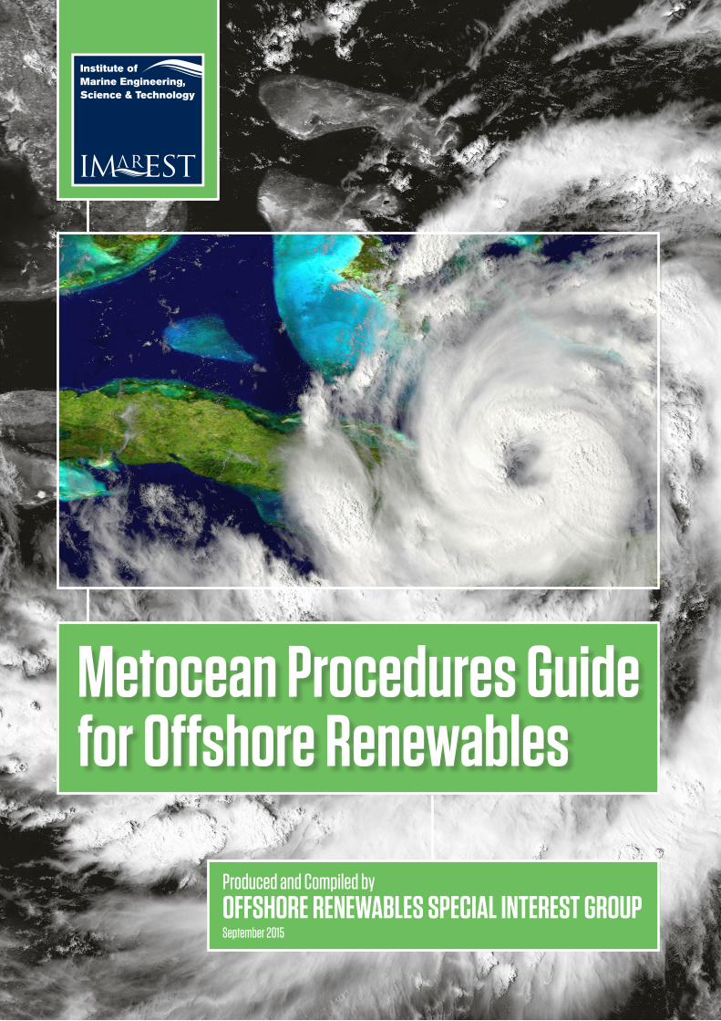
Metocean Procedures Guide for Offshore Renewables Produced and Compiled by OFFSHORE RENEWABLES SPECIAL INTEREST GROUP September 2015
Metocean Procedures Guide for Offshore Renewables
Produced and Compiled byOFFSHORE RENEWABLES SPECIAL INTEREST GROUPSeptember 2015
CONTENTS1. INTRODUCTION. . . . . . . . . . . . . . . . . . . . . . . . . . . . . . . . . . . . . . . . . . . . . . . . . . . . . . . . . . . . . . . . . . . . . . . . . . . . . . . . . . . . . . . . . . . . . . . . . . . . . . . . . . . . . . . . . . . . . . . . . . . . . . . . . . . . . . . . . . . . . . . . . . . . . . . . . . . . . . . . . . . . . . . . . . . . . . . . . . . . . . . . . . . . . . . . . . . . . . . . .2
2. METOCEAN CONSIDERATIONS . . . . . . . . . . . . . . . . . . . . . . . . . . . . . . . . . . . . . . . . . . . . . . . . . . . . . . . . . . . . . . . . . . . . . . . . . . . . . . . . . . . . . . . . . . . . . . . . . . . . . . . . . . . . . . . . . . . . . . . . . . . . . . . . . . . . . . . . . . . . . . . . . . . . . . . . . . . . . . . . . . . . . . . . . . . . . . . . . . . . . . . . . . . . . . . . . . . . . . . . . . . . . . . . . . . . . . . . . . . . . . . . . . . . . . . . . . . . . . . . . . . . . . . . . . . . . . . . . . . . . . . . .22.1 Cost Implications for Metocean Inputs. . . . . . . . . . . . . . . . . . . . . . . . . . . . . . . . . . . . . . . . . . . . . . . . . . . . . . . . . . . . . . . . . . . . . . . . . . . . . . . . . . . . . . . . . . . . . . . . . . . . . . . . . . . . . . . . . . . . . . . . . . . . . . . . . . . . . . . . . . . . . . . . . . . . . . . . . . . . . . . . . . . . . . . . . . . . . . . . . . . . . . . . . . . . . . . . . . . . . . . . . . . . . . . . . . . . . . . . . . . . . . . . . . . . . . . . . . . . . . . . . . . . . . . . . .32.2 An Integrated Metocean Approach. . . . . . . . . . . . . . . . . . . . . . . . . . . . . . . . . . . . . . . . . . . . . . . . . . . . . . . . . . . . . . . . . . . . . . . . . . . . . . . . . . . . . . . . . . . . . . . . . . . . . . . . . . . . . . . . . . . . . . . . . . . . . . . . . . . . . . . . . . . . . . . . . . . . . . . . . . . . . . . . . . . . . . . . . . . . . . . . . . . . . . . . . . . . . . . . . . . . . . . . . . . . . . . . . . . . . . . . . . . . . . . . . . . . . . . . . . . . . . . . . . . . . . . . . . . . . . . . . .32.3 Metocean Focal Point . . . . . . . . . . . . . . . . . . . . . . . . . . . . . . . . . . . . . . . . . . . . . . . . . . . . . . . . . . . . . . . . . . . . . . . . . . . . . . . . . . . . . . . . . . . . . . . . . . . . . . . . . . . . . . . . . . . . . . . . . . . . . . . . . . . . . . . . . . . . . . . . . . . . . . . . . . . . . . . . . . . . . . . . . . . . . . . . . . . . . . . . . . . . . . . . . . . . . . . . . . . . . . . . . . . . . . . . . . . . . . . . . . . . . . . . . . . . . . . . . . . . . . . . . . . . . . . . . . . . . . . . . . . . . . . . . . . . . . . . . .3
3. METOCEAN THROUGH PROJECT LIFECYCLE . . . . . . . . . . . . . . . . . . . . . . . . . . . . . . . . . . . . . . . . . . . . . . . . . . . . . . . . . . . . . . . . . . . . . . . . . . . . . . . . . . . . . . . . . . . . . . . . . . . . . . . . . . . . . . . . . . . . . . . . . . . . . . . . . . . . . . . . . . . . . . . . . . . . . . . . . . . . . . . . . . . . . . . . . . . . . . . . . . . . . . . . . . . . . . . . . . . . . . . . . . . . . . . . . . . . . . . . . . . . . . . . . . . . . . . . . . . .43.1 Site Selection and Feasibility . . . . . . . . . . . . . . . . . . . . . . . . . . . . . . . . . . . . . . . . . . . . . . . . . . . . . . . . . . . . . . . . . . . . . . . . . . . . . . . . . . . . . . . . . . . . . . . . . . . . . . . . . . . . . . . . . . . . . . . . . . . . . . . . . . . . . . . . . . . . . . . . . . . . . . . . . . . . . . . . . . . . . . . . . . . . . . . . . . . . . . . . . . . . . . . . . . . . . . . . . . . . . . . . . . . . . . . . . . . . . . . . . . . . . . . . . . . . . . . . . . . . . . . . . . . . . . . . . . . . . . . . . . . .43.2 Development and Consents . . . . . . . . . . . . . . . . . . . . . . . . . . . . . . . . . . . . . . . . . . . . . . . . . . . . . . . . . . . . . . . . . . . . . . . . . . . . . . . . . . . . . . . . . . . . . . . . . . . . . . . . . . . . . . . . . . . . . . . . . . . . . . . . . . . . . . . . . . . . . . . . . . . . . . . . . . . . . . . . . . . . . . . . . . . . . . . . . . . . . . . . . . . . . . . . . . . . . . . . . . . . . . . . . . . . . . . . . . . . . . . . . . . . . . . . . . . . . . . . . . . . . . . . . . . . . . . . . . . . . . . . . . . . . .43.3 Design . . . . . . . . . . . . . . . . . . . . . . . . . . . . . . . . . . . . . . . . . . . . . . . . . . . . . . . . . . . . . . . . . . . . . . . . . . . . . . . . . . . . . . . . . . . . . . . . . . . . . . . . . . . . . . . . . . . . . . . . . . . . . . . . . . . . . . . . . . . . . . . . . . . . . . . . . . . . . . . . . . . . . . . . . . . . . . . . . . . . . . . . . . . . . . . . . . . . . . . . . . . . . . . . . . . . . . . . . . . . . . . . . . . . . . . . . . . . . . . . . . . . . . . . . . . . . . . . . . . . . . . . . . . . . . . . . . . . . . . . . . . . . . . . . . . . . . . . . . . . . . . . . . . . . . .43.4 Installation. . . . . . . . . . . . . . . . . . . . . . . . . . . . . . . . . . . . . . . . . . . . . . . . . . . . . . . . . . . . . . . . . . . . . . . . . . . . . . . . . . . . . . . . . . . . . . . . . . . . . . . . . . . . . . . . . . . . . . . . . . . . . . . . . . . . . . . . . . . . . . . . . . . . . . . . . . . . . . . . . . . . . . . . . . . . . . . . . . . . . . . . . . . . . . . . . . . . . . . . . . . . . . . . . . . . . . . . . . . . . . . . . . . . . . . . . . . . . . . . . . . . . . . . . . . . . . . . . . . . . . . . . . . . . . . . . . . . . . . . . . . . . . . . . . . . . . . . . . . . . . .53.5 Operations and Maintenance (O+M) . . . . . . . . . . . . . . . . . . . . . . . . . . . . . . . . . . . . . . . . . . . . . . . . . . . . . . . . . . . . . . . . . . . . . . . . . . . . . . . . . . . . . . . . . . . . . . . . . . . . . . . . . . . . . . . . . . . . . . . . . . . . . . . . . . . . . . . . . . . . . . . . . . . . . . . . . . . . . . . . . . . . . . . . . . . . . . . . . . . . . . . . . . . . . . . . . . . . . . . . . . . . . . . . . . . . . . . . . . . . . . . . . . . . . . . . . . . . . . . . . . . . . . . . . . . . . . .53.6 Decommissioning. . . . . . . . . . . . . . . . . . . . . . . . . . . . . . . . . . . . . . . . . . . . . . . . . . . . . . . . . . . . . . . . . . . . . . . . . . . . . . . . . . . . . . . . . . . . . . . . . . . . . . . . . . . . . . . . . . . . . . . . . . . . . . . . . . . . . . . . . . . . . . . . . . . . . . . . . . . . . . . . . . . . . . . . . . . . . . . . . . . . . . . . . . . . . . . . . . . . . . . . . . . . . . . . . . . . . . . . . . . . . . . . . . . . . . . . . . . . . . . . . . . . . . . . . . . . . . . . . . . . . . . . . . . . . . . . . . . . . . . . . . . . . . . . .5
4. METOCEAN STANDARDS . . . . . . . . . . . . . . . . . . . . . . . . . . . . . . . . . . . . . . . . . . . . . . . . . . . . . . . . . . . . . . . . . . . . . . . . . . . . . . . . . . . . . . . . . . . . . . . . . . . . . . . . . . . . . . . . . . . . . . . . . . . . . . . . . . . . . . . . . . . . . . . . . . . . . . . . . . . . . . . . . . . . . . . . . . . . . . . . . . . . . . . . . . . . . . . . . . . . . . . . . . . . . . . . . . . . . . . . . . . . . . . . . . . . . . . . . . . . . . . . . . . . . . . . . . . . . . . . . . . . . . . . . . . . . . . . . . . . . .54.1 General. . . . . . . . . . . . . . . . . . . . . . . . . . . . . . . . . . . . . . . . . . . . . . . . . . . . . . . . . . . . . . . . . . . . . . . . . . . . . . . . . . . . . . . . . . . . . . . . . . . . . . . . . . . . . . . . . . . . . . . . . . . . . . . . . . . . . . . . . . . . . . . . . . . . . . . . . . . . . . . . . . . . . . . . . . . . . . . . . . . . . . . . . . . . . . . . . . . . . . . . . . . . . . . . . . . . . . . . . . . . . . . . . . . . . . . . . . . . . . . . . . . . . . . . . . . . . . . . . . . . . . . . . . . . . . . . . . . . . . . . . . . . . . . . . . . . . . . . . . . . . . . . . . . . . .54.2 Background to Key Documents . . . . . . . . . . . . . . . . . . . . . . . . . . . . . . . . . . . . . . . . . . . . . . . . . . . . . . . . . . . . . . . . . . . . . . . . . . . . . . . . . . . . . . . . . . . . . . . . . . . . . . . . . . . . . . . . . . . . . . . . . . . . . . . . . . . . . . . . . . . . . . . . . . . . . . . . . . . . . . . . . . . . . . . . . . . . . . . . . . . . . . . . . . . . . . . . . . . . . . . . . . . . . . . . . . . . . . . . . . . . . . . . . . . . . . . . . . . . . . . . . . . . . . . . . . . . . . . . . . . . . . . .5
5. METOCEAN DATA SOURCES AND MANAGEMENT . . . . . . . . . . . . . . . . . . . . . . . . . . . . . . . . . . . . . . . . . . . . . . . . . . . . . . . . . . . . . . . . . . . . . . . . . . . . . . . . . . . . . . . . . . . . . . . . . . . . . . . . . . . . . . . . . . . . . . . . . . . . . . . . . . . . . . . . . . . . . . . . . . . . . . . . . . . . . . . . . . . . . . . . . . . . . . . . . . . . . . . . . . . . . . . . . . . . . . . . . . . . . . . . . . . . . . . . . . . . . . . 75.1 Data Sources . . . . . . . . . . . . . . . . . . . . . . . . . . . . . . . . . . . . . . . . . . . . . . . . . . . . . . . . . . . . . . . . . . . . . . . . . . . . . . . . . . . . . . . . . . . . . . . . . . . . . . . . . . . . . . . . . . . . . . . . . . . . . . . . . . . . . . . . . . . . . . . . . . . . . . . . . . . . . . . . . . . . . . . . . . . . . . . . . . . . . . . . . . . . . . . . . . . . . . . . . . . . . . . . . . . . . . . . . . . . . . . . . . . . . . . . . . . . . . . . . . . . . . . . . . . . . . . . . . . . . . . . . . . . . . . . . . . . . . . . . . . . . . . . . . . . . . . . . . 75.2 Metocean Processes . . . . . . . . . . . . . . . . . . . . . . . . . . . . . . . . . . . . . . . . . . . . . . . . . . . . . . . . . . . . . . . . . . . . . . . . . . . . . . . . . . . . . . . . . . . . . . . . . . . . . . . . . . . . . . . . . . . . . . . . . . . . . . . . . . . . . . . . . . . . . . . . . . . . . . . . . . . . . . . . . . . . . . . . . . . . . . . . . . . . . . . . . . . . . . . . . . . . . . . . . . . . . . . . . . . . . . . . . . . . . . . . . . . . . . . . . . . . . . . . . . . . . . . . . . . . . . . . . . . . . . . . . . . . . . . . . . . . . . . . . . . 75.3 Data Management. . . . . . . . . . . . . . . . . . . . . . . . . . . . . . . . . . . . . . . . . . . . . . . . . . . . . . . . . . . . . . . . . . . . . . . . . . . . . . . . . . . . . . . . . . . . . . . . . . . . . . . . . . . . . . . . . . . . . . . . . . . . . . . . . . . . . . . . . . . . . . . . . . . . . . . . . . . . . . . . . . . . . . . . . . . . . . . . . . . . . . . . . . . . . . . . . . . . . . . . . . . . . . . . . . . . . . . . . . . . . . . . . . . . . . . . . . . . . . . . . . . . . . . . . . . . . . . . . . . . . . . . . . . . . . . . . . . . . . . . . . . . . . . . . 75.4 Metocean Contractors. . . . . . . . . . . . . . . . . . . . . . . . . . . . . . . . . . . . . . . . . . . . . . . . . . . . . . . . . . . . . . . . . . . . . . . . . . . . . . . . . . . . . . . . . . . . . . . . . . . . . . . . . . . . . . . . . . . . . . . . . . . . . . . . . . . . . . . . . . . . . . . . . . . . . . . . . . . . . . . . . . . . . . . . . . . . . . . . . . . . . . . . . . . . . . . . . . . . . . . . . . . . . . . . . . . . . . . . . . . . . . . . . . . . . . . . . . . . . . . . . . . . . . . . . . . . . . . . . . . . . . . . . . . . . . . . . . . . . . . . 8
6. METOCEAN STRATEGY . . . . . . . . . . . . . . . . . . . . . . . . . . . . . . . . . . . . . . . . . . . . . . . . . . . . . . . . . . . . . . . . . . . . . . . . . . . . . . . . . . . . . . . . . . . . . . . . . . . . . . . . . . . . . . . . . . . . . . . . . . . . . . . . . . . . . . . . . . . . . . . . . . . . . . . . . . . . . . . . . . . . . . . . . . . . . . . . . . . . . . . . . . . . . . . . . . . . . . . . . . . . . . . . . . . . . . . . . . . . . . . . . . . . . . . . . . . . . . . . . . . . . . . . . . . . . . . . . . . . . . . . . . . . . . . . . . . . . . . . . . 96.1 Briefing Note . . . . . . . . . . . . . . . . . . . . . . . . . . . . . . . . . . . . . . . . . . . . . . . . . . . . . . . . . . . . . . . . . . . . . . . . . . . . . . . . . . . . . . . . . . . . . . . . . . . . . . . . . . . . . . . . . . . . . . . . . . . . . . . . . . . . . . . . . . . . . . . . . . . . . . . . . . . . . . . . . . . . . . . . . . . . . . . . . . . . . . . . . . . . . . . . . . . . . . . . . . . . . . . . . . . . . . . . . . . . . . . . . . . . . . . . . . . . . . . . . . . . . . . . . . . . . . . . . . . . . . . . . . . . . . . . . . . . . . . . . . . . . . . . . . . . . . . . . . 96.2 Preliminary Data and Analyses . . . . . . . . . . . . . . . . . . . . . . . . . . . . . . . . . . . . . . . . . . . . . . . . . . . . . . . . . . . . . . . . . . . . . . . . . . . . . . . . . . . . . . . . . . . . . . . . . . . . . . . . . . . . . . . . . . . . . . . . . . . . . . . . . . . . . . . . . . . . . . . . . . . . . . . . . . . . . . . . . . . . . . . . . . . . . . . . . . . . . . . . . . . . . . . . . . . . . . . . . . . . . . . . . . . . . . . . . . . . . . . . . . . . . . . . . . . . . . . . . . . . . . . . . . . . . . . . . . . . . . . . 96.3 Full Data and Analyses. . . . . . . . . . . . . . . . . . . . . . . . . . . . . . . . . . . . . . . . . . . . . . . . . . . . . . . . . . . . . . . . . . . . . . . . . . . . . . . . . . . . . . . . . . . . . . . . . . . . . . . . . . . . . . . . . . . . . . . . . . . . . . . . . . . . . . . . . . . . . . . . . . . . . . . . . . . . . . . . . . . . . . . . . . . . . . . . . . . . . . . . . . . . . . . . . . . . . . . . . . . . . . . . . . . . . . . . . . . . . . . . . . . . . . . . . . . . . . . . . . . . . . . . . . . . . . . . . . . . . . . . . . . . . . . . . . . . . . . . 96.4 Other Products and Analyses . . . . . . . . . . . . . . . . . . . . . . . . . . . . . . . . . . . . . . . . . . . . . . . . . . . . . . . . . . . . . . . . . . . . . . . . . . . . . . . . . . . . . . . . . . . . . . . . . . . . . . . . . . . . . . . . . . . . . . . . . . . . . . . . . . . . . . . . . . . . . . . . . . . . . . . . . . . . . . . . . . . . . . . . . . . . . . . . . . . . . . . . . . . . . . . . . . . . . . . . . . . . . . . . . . . . . . . . . . . . . . . . . . . . . . . . . . . . . . . . . . . . . . . . . . . . . . . . . . . . . . . . . . 106.5 Strategy Overview. . . . . . . . . . . . . . . . . . . . . . . . . . . . . . . . . . . . . . . . . . . . . . . . . . . . . . . . . . . . . . . . . . . . . . . . . . . . . . . . . . . . . . . . . . . . . . . . . . . . . . . . . . . . . . . . . . . . . . . . . . . . . . . . . . . . . . . . . . . . . . . . . . . . . . . . . . . . . . . . . . . . . . . . . . . . . . . . . . . . . . . . . . . . . . . . . . . . . . . . . . . . . . . . . . . . . . . . . . . . . . . . . . . . . . . . . . . . . . . . . . . . . . . . . . . . . . . . . . . . . . . . . . . . . . . . . . . . . . . . . . . . . . . 10
7. REFERENCES . . . . . . . . . . . . . . . . . . . . . . . . . . . . . . . . . . . . . . . . . . . . . . . . . . . . . . . . . . . . . . . . . . . . . . . . . . . . . . . . . . . . . . . . . . . . . . . . . . . . . . . . . . . . . . . . . . . . . . . . . . . . . . . . . . . . . . . . . . . . . . . . . . . . . . . . . . . . . . . . . . . . . . . . . . . . . . . . . . . . . . . . . . . . . . . . . . . . . . . . . . . . . . . . . . . . . . . . . . . . . . . . . . . . . . . . . . . . . . . . . . . . . . . . . . . . . . . . . . . . . . . . . . . . . . . . . . . . . . . . . . . . . . . . . . . . . . . . . . . . . . . . 11
APPENDIX 1 – STANDARDS . . . . . . . . . . . . . . . . . . . . . . . . . . . . . . . . . . . . . . . . . . . . . . . . . . . . . . . . . . . . . . . . . . . . . . . . . . . . . . . . . . . . . . . . . . . . . . . . . . . . . . . . . . . . . . . . . . . . . . . . . . . . . . . . . . . . . . . . . . . . . . . . . . . . . . . . . . . . . . . . . . . . . . . . . . . . . . . . . . . . . . . . . . . . . . . . . . . . . . . . . . . . . . . . . . . . . . . . . . . . . . . . . . . . . . . . . . . . . . . . . . . . . . . . . . . . . . . . . . . . . . . . . . . . . . . . 11A1.1 Oil and Gas . . . . . . . . . . . . . . . . . . . . . . . . . . . . . . . . . . . . . . . . . . . . . . . . . . . . . . . . . . . . . . . . . . . . . . . . . . . . . . . . . . . . . . . . . . . . . . . . . . . . . . . . . . . . . . . . . . . . . . . . . . . . . . . . . . . . . . . . . . . . . . . . . . . . . . . . . . . . . . . . . . . . . . . . . . . . . . . . . . . . . . . . . . . . . . . . . . . . . . . . . . . . . . . . . . . . . . . . . . . . . . . . . . . . . . . . . . . . . . . . . . . . . . . . . . . . . . . . . . . . . . . . . . . . . . . . . . . . . . . . . . . . . . . . . . . . . . . . . . . . . . 11A1.2 Renewable Energy . . . . . . . . . . . . . . . . . . . . . . . . . . . . . . . . . . . . . . . . . . . . . . . . . . . . . . . . . . . . . . . . . . . . . . . . . . . . . . . . . . . . . . . . . . . . . . . . . . . . . . . . . . . . . . . . . . . . . . . . . . . . . . . . . . . . . . . . . . . . . . . . . . . . . . . . . . . . . . . . . . . . . . . . . . . . . . . . . . . . . . . . . . . . . . . . . . . . . . . . . . . . . . . . . . . . . . . . . . . . . . . . . . . . . . . . . . . . . . . . . . . . . . . . . . . . . . . . . . . . . . . . . . . . . . . . . . . . . . . . . . . . . . . 11A1.3 Other . . . . . . . . . . . . . . . . . . . . . . . . . . . . . . . . . . . . . . . . . . . . . . . . . . . . . . . . . . . . . . . . . . . . . . . . . . . . . . . . . . . . . . . . . . . . . . . . . . . . . . . . . . . . . . . . . . . . . . . . . . . . . . . . . . . . . . . . . . . . . . . . . . . . . . . . . . . . . . . . . . . . . . . . . . . . . . . . . . . . . . . . . . . . . . . . . . . . . . . . . . . . . . . . . . . . . . . . . . . . . . . . . . . . . . . . . . . . . . . . . . . . . . . . . . . . . . . . . . . . . . . . . . . . . . . . . . . . . . . . . . . . . . . . . . . . . . . . . . . . . . . . . . . . . . . . 12
APPENDIX 2 - GLOSSARY . . . . . . . . . . . . . . . . . . . . . . . . . . . . . . . . . . . . . . . . . . . . . . . . . . . . . . . . . . . . . . . . . . . . . . . . . . . . . . . . . . . . . . . . . . . . . . . . . . . . . . . . . . . . . . . . . . . . . . . . . . . . . . . . . . . . . . . . . . . . . . . . . . . . . . . . . . . . . . . . . . . . . . . . . . . . . . . . . . . . . . . . . . . . . . . . . . . . . . . . . . . . . . . . . . . . . . . . . . . . . . . . . . . . . . . . . . . . . . . . . . . . . . . . . . . . . . . . . . . . . . . . . . . . . . . . . . . 13A2.1 General . . . . . . . . . . . . . . . . . . . . . . . . . . . . . . . . . . . . . . . . . . . . . . . . . . . . . . . . . . . . . . . . . . . . . . . . . . . . . . . . . . . . . . . . . . . . . . . . . . . . . . . . . . . . . . . . . . . . . . . . . . . . . . . . . . . . . . . . . . . . . . . . . . . . . . . . . . . . . . . . . . . . . . . . . . . . . . . . . . . . . . . . . . . . . . . . . . . . . . . . . . . . . . . . . . . . . . . . . . . . . . . . . . . . . . . . . . . . . . . . . . . . . . . . . . . . . . . . . . . . . . . . . . . . . . . . . . . . . . . . . . . . . . . . . . . . . . . . . . . . . . . . . . . . . . . 13A2.2 Wind. . . . . . . . . . . . . . . . . . . . . . . . . . . . . . . . . . . . . . . . . . . . . . . . . . . . . . . . . . . . . . . . . . . . . . . . . . . . . . . . . . . . . . . . . . . . . . . . . . . . . . . . . . . . . . . . . . . . . . . . . . . . . . . . . . . . . . . . . . . . . . . . . . . . . . . . . . . . . . . . . . . . . . . . . . . . . . . . . . . . . . . . . . . . . . . . . . . . . . . . . . . . . . . . . . . . . . . . . . . . . . . . . . . . . . . . . . . . . . . . . . . . . . . . . . . . . . . . . . . . . . . . . . . . . . . . . . . . . . . . . . . . . . . . . . . . . . . . . . . . . . . . . . . . . . . . . . . 14A2.3 Wave. . . . . . . . . . . . . . . . . . . . . . . . . . . . . . . . . . . . . . . . . . . . . . . . . . . . . . . . . . . . . . . . . . . . . . . . . . . . . . . . . . . . . . . . . . . . . . . . . . . . . . . . . . . . . . . . . . . . . . . . . . . . . . . . . . . . . . . . . . . . . . . . . . . . . . . . . . . . . . . . . . . . . . . . . . . . . . . . . . . . . . . . . . . . . . . . . . . . . . . . . . . . . . . . . . . . . . . . . . . . . . . . . . . . . . . . . . . . . . . . . . . . . . . . . . . . . . . . . . . . . . . . . . . . . . . . . . . . . . . . . . . . . . . . . . . . . . . . . . . . . . . . . . . . . . . . . . 14A2.4 Current . . . . . . . . . . . . . . . . . . . . . . . . . . . . . . . . . . . . . . . . . . . . . . . . . . . . . . . . . . . . . . . . . . . . . . . . . . . . . . . . . . . . . . . . . . . . . . . . . . . . . . . . . . . . . . . . . . . . . . . . . . . . . . . . . . . . . . . . . . . . . . . . . . . . . . . . . . . . . . . . . . . . . . . . . . . . . . . . . . . . . . . . . . . . . . . . . . . . . . . . . . . . . . . . . . . . . . . . . . . . . . . . . . . . . . . . . . . . . . . . . . . . . . . . . . . . . . . . . . . . . . . . . . . . . . . . . . . . . . . . . . . . . . . . . . . . . . . . . . . . . . . . . . . . . . 15A2.5 Water Levels. . . . . . . . . . . . . . . . . . . . . . . . . . . . . . . . . . . . . . . . . . . . . . . . . . . . . . . . . . . . . . . . . . . . . . . . . . . . . . . . . . . . . . . . . . . . . . . . . . . . . . . . . . . . . . . . . . . . . . . . . . . . . . . . . . . . . . . . . . . . . . . . . . . . . . . . . . . . . . . . . . . . . . . . . . . . . . . . . . . . . . . . . . . . . . . . . . . . . . . . . . . . . . . . . . . . . . . . . . . . . . . . . . . . . . . . . . . . . . . . . . . . . . . . . . . . . . . . . . . . . . . . . . . . . . . . . . . . . . . . . . . . . . . . . . . . . . . . . . . . 15A2.6 Units and Convention. . . . . . . . . . . . . . . . . . . . . . . . . . . . . . . . . . . . . . . . . . . . . . . . . . . . . . . . . . . . . . . . . . . . . . . . . . . . . . . . . . . . . . . . . . . . . . . . . . . . . . . . . . . . . . . . . . . . . . . . . . . . . . . . . . . . . . . . . . . . . . . . . . . . . . . . . . . . . . . . . . . . . . . . . . . . . . . . . . . . . . . . . . . . . . . . . . . . . . . . . . . . . . . . . . . . . . . . . . . . . . . . . . . . . . . . . . . . . . . . . . . . . . . . . . . . . . . . . . . . . . . . . . . . . . . . . . . . . . . . . . . 15
APPENDIX 3 – IN-SITU DATA COLLECTION. . . . . . . . . . . . . . . . . . . . . . . . . . . . . . . . . . . . . . . . . . . . . . . . . . . . . . . . . . . . . . . . . . . . . . . . . . . . . . . . . . . . . . . . . . . . . . . . . . . . . . . . . . . . . . . . . . . . . . . . . . . . . . . . . . . . . . . . . . . . . . . . . . . . . . . . . . . . . . . . . . . . . . . . . . . . . . . . . . . . . . . . . . . . . . . . . . . . . . . . . . . . . . . . . . . . . . . . . . . . . . . . . . . . . . . . . . . . 16A3.1 Scope of Works . . . . . . . . . . . . . . . . . . . . . . . . . . . . . . . . . . . . . . . . . . . . . . . . . . . . . . . . . . . . . . . . . . . . . . . . . . . . . . . . . . . . . . . . . . . . . . . . . . . . . . . . . . . . . . . . . . . . . . . . . . . . . . . . . . . . . . . . . . . . . . . . . . . . . . . . . . . . . . . . . . . . . . . . . . . . . . . . . . . . . . . . . . . . . . . . . . . . . . . . . . . . . . . . . . . . . . . . . . . . . . . . . . . . . . . . . . . . . . . . . . . . . . . . . . . . . . . . . . . . . . . . . . . . . . . . . . . . . . . . . . . . . . . . . . . . . . . 16A3.2 Schedule . . . . . . . . . . . . . . . . . . . . . . . . . . . . . . . . . . . . . . . . . . . . . . . . . . . . . . . . . . . . . . . . . . . . . . . . . . . . . . . . . . . . . . . . . . . . . . . . . . . . . . . . . . . . . . . . . . . . . . . . . . . . . . . . . . . . . . . . . . . . . . . . . . . . . . . . . . . . . . . . . . . . . . . . . . . . . . . . . . . . . . . . . . . . . . . . . . . . . . . . . . . . . . . . . . . . . . . . . . . . . . . . . . . . . . . . . . . . . . . . . . . . . . . . . . . . . . . . . . . . . . . . . . . . . . . . . . . . . . . . . . . . . . . . . . . . . . . . . . . . . . . . . . .17A3.3 Data and Equipment Loss . . . . . . . . . . . . . . . . . . . . . . . . . . . . . . . . . . . . . . . . . . . . . . . . . . . . . . . . . . . . . . . . . . . . . . . . . . . . . . . . . . . . . . . . . . . . . . . . . . . . . . . . . . . . . . . . . . . . . . . . . . . . . . . . . . . . . . . . . . . . . . . . . . . . . . . . . . . . . . . . . . . . . . . . . . . . . . . . . . . . . . . . . . . . . . . . . . . . . . . . . . . . . . . . . . . . . . . . . . . . . . . . . . . . . . . . . . . . . . . . . . . . . . . . . . . . . . . . . . . . . . . . . . . . . . . . . . . .17A3.4 Data Specification . . . . . . . . . . . . . . . . . . . . . . . . . . . . . . . . . . . . . . . . . . . . . . . . . . . . . . . . . . . . . . . . . . . . . . . . . . . . . . . . . . . . . . . . . . . . . . . . . . . . . . . . . . . . . . . . . . . . . . . . . . . . . . . . . . . . . . . . . . . . . . . . . . . . . . . . . . . . . . . . . . . . . . . . . . . . . . . . . . . . . . . . . . . . . . . . . . . . . . . . . . . . . . . . . . . . . . . . . . . . . . . . . . . . . . . . . . . . . . . . . . . . . . . . . . . . . . . . . . . . . . . . . . . . . . . . . . . . . . . . . . . . . . . . . .17A3.5 Health, Safety and Environment . . . . . . . . . . . . . . . . . . . . . . . . . . . . . . . . . . . . . . . . . . . . . . . . . . . . . . . . . . . . . . . . . . . . . . . . . . . . . . . . . . . . . . . . . . . . . . . . . . . . . . . . . . . . . . . . . . . . . . . . . . . . . . . . . . . . . . . . . . . . . . . . . . . . . . . . . . . . . . . . . . . . . . . . . . . . . . . . . . . . . . . . . . . . . . . . . . . . . . . . . . . . . . . . . . . . . . . . . . . . . . . . . . . . . . . . . . . . . . . . . . . . . . . . . . . . . . . . . . . . . . . .17A3.6 Measurement Camapign Specification Sheet. . . . . . . . . . . . . . . . . . . . . . . . . . . . . . . . . . . . . . . . . . . . . . . . . . . . . . . . . . . . . . . . . . . . . . . . . . . . . . . . . . . . . . . . . . . . . . . . . . . . . . . . . . . . . . . . . . . . . . . . . . . . . . . . . . . . . . . . . . . . . . . . . . . . . . . . . . . . . . . . . . . . . . . . . . . . . . . . . . . . . . . . . . . . . . . . . . . . . . . . . . . . . . . . . . . . . . . . . . . . . . . . . . . . . . . . . . . . . .17
APPENDIX 4 – MODELLING . . . . . . . . . . . . . . . . . . . . . . . . . . . . . . . . . . . . . . . . . . . . . . . . . . . . . . . . . . . . . . . . . . . . . . . . . . . . . . . . . . . . . . . . . . . . . . . . . . . . . . . . . . . . . . . . . . . . . . . . . . . . . . . . . . . . . . . . . . . . . . . . . . . . . . . . . . . . . . . . . . . . . . . . . . . . . . . . . . . . . . . . . . . . . . . . . . . . . . . . . . . . . . . . . . . . . . . . . . . . . . . . . . . . . . . . . . . . . . . . . . . . . . . . . . . . . . . . . . . . . . . . . . . . . .20A4.1 Deliverables. . . . . . . . . . . . . . . . . . . . . . . . . . . . . . . . . . . . . . . . . . . . . . . . . . . . . . . . . . . . . . . . . . . . . . . . . . . . . . . . . . . . . . . . . . . . . . . . . . . . . . . . . . . . . . . . . . . . . . . . . . . . . . . . . . . . . . . . . . . . . . . . . . . . . . . . . . . . . . . . . . . . . . . . . . . . . . . . . . . . . . . . . . . . . . . . . . . . . . . . . . . . . . . . . . . . . . . . . . . . . . . . . . . . . . . . . . . . . . . . . . . . . . . . . . . . . . . . . . . . . . . . . . . . . . . . . . . . . . . . . . . . . . . . . . . . . . . . . . . . .20A4.2 Inputs . . . . . . . . . . . . . . . . . . . . . . . . . . . . . . . . . . . . . . . . . . . . . . . . . . . . . . . . . . . . . . . . . . . . . . . . . . . . . . . . . . . . . . . . . . . . . . . . . . . . . . . . . . . . . . . . . . . . . . . . . . . . . . . . . . . . . . . . . . . . . . . . . . . . . . . . . . . . . . . . . . . . . . . . . . . . . . . . . . . . . . . . . . . . . . . . . . . . . . . . . . . . . . . . . . . . . . . . . . . . . . . . . . . . . . . . . . . . . . . . . . . . . . . . . . . . . . . . . . . . . . . . . . . . . . . . . . . . . . . . . . . . . . . . . . . . . . . . . . . . . . . . . . . . . . .20A4.3 Methodology. . . . . . . . . . . . . . . . . . . . . . . . . . . . . . . . . . . . . . . . . . . . . . . . . . . . . . . . . . . . . . . . . . . . . . . . . . . . . . . . . . . . . . . . . . . . . . . . . . . . . . . . . . . . . . . . . . . . . . . . . . . . . . . . . . . . . . . . . . . . . . . . . . . . . . . . . . . . . . . . . . . . . . . . . . . . . . . . . . . . . . . . . . . . . . . . . . . . . . . . . . . . . . . . . . . . . . . . . . . . . . . . . . . . . . . . . . . . . . . . . . . . . . . . . . . . . . . . . . . . . . . . . . . . . . . . . . . . . . . . . . . . . . . . . . . . . . . . . .20
METOCEAN PROCEDURES GUIDE (MPG) 1
1. INTRODUCTION This procedures guide outlines the metocean activities required to support all phases of an offshore renew-able (OR) energy project, through development and construction to ongoing operations and maintenance (O+M). It is intended as a tool for all those involved in offshore renewables, including project managers, structural engineers, surveyors and logistics personnel, based within OR companies or support organisations and contractors.
Metocean is a technical engineering discipline that ad-dresses meteorological and physical oceanographic matters. It originated in the oil and gas sector in the late 1970s and is equally applicable to the OR sector. Me-tocean is primarily concerned with quantifying the ef-fects of weather and sea conditions (specifically wind, wave, current and water level) and more broadly on the physical aspects of the water column (such as conduc-tivity and temperature).
As metocean is specifically concerned with physical oceanography it does not address chemical, biologi-cal or environmental considerations. However, there is overlap between metocean and environmental requirements, so (where appropriate) collaboration between the two disciplines should be considered to enable cost savings. Metocean in the context of this
document excludes information on the energy re-source itself (e.g. the tidal, current or wind resource that will generate the energy), although it is highly relevant to the identification of suitable data sources and the acquisition of data from which resource as-sessments can be reliably derived.
Whilst this document relies heavily upon experience gained from offshore wind developments on fixed structures, the majority of it is also applicable to emerging technologies, including floating wind, wave and tidal. It draws primarily on UK experience but pro-cedures may be applied in other parts of the world tak-ing into account relevant local standards.
This guide applies to the OR site area, maintenance base(s) and access routes throughout a project’s life, from early development through to decommissioning, and can also be used to support Environmental Im-pact Assessment (EIA) during the consenting process. The majority of the associated metocean activities take place during the development and pre-construction stages of the project.
It must be emphasised that this is a generic guide illus-trating typical approaches to be adopted. The imple-mentation of the metocean strategy in reality may vary from the approach suggested as different projects have different stages within their governance processes that may not correspond directly. However, the principles will be the same. It is necessary at the outset of a project to programme the key milestones and outline the cor-responding metocean requirements.
A concise list of references, applicable standards and a glossary of terms are included.
2. METOCEAN CONSIDERATIONSAll offshore activities are affected by prevailing me-tocean conditions. There is a requirement for me-tocean information and support at all stages of a project and throughout its operation after installa-tion. A recommended strategy for ensuring this in-formation and support is provided appropriately is outlined in Section 6 and presented in terms of key deliverables.
Because many of the metocean requirements are de-pendent on one another, for example, reliable statistics need quality long-term datasets, it makes sense to view and conduct metocean activities in a co-ordinated and integrated way.
ACKNOWLEDGEMENTSThe Offshore Renewables Special Interest Group (ORSIG) has produced and compiled this proce-dure guide, with support from the Operational Oceanography Special Interest Group (OOSIG). It is based on a draft document originally produced for SSE Renewables by Ian Leggett of OceanExpert Limited in 2012.
IMarEST members who have contributed are:Name CompanyLaure Grignon RES OffshoreGus Jeans OceanalysisIan Leggett OceanExpertAdam Nicholls GardlineMicheal O’Cathain SSE RenewablesJames Parker CefasZoe Roberts Vattenfall Wind PowerAlastair Stagg Fugro GEOSRichard Wakefield Atkins
2 METOCEAN PROCEDURES GUIDE (MPG)
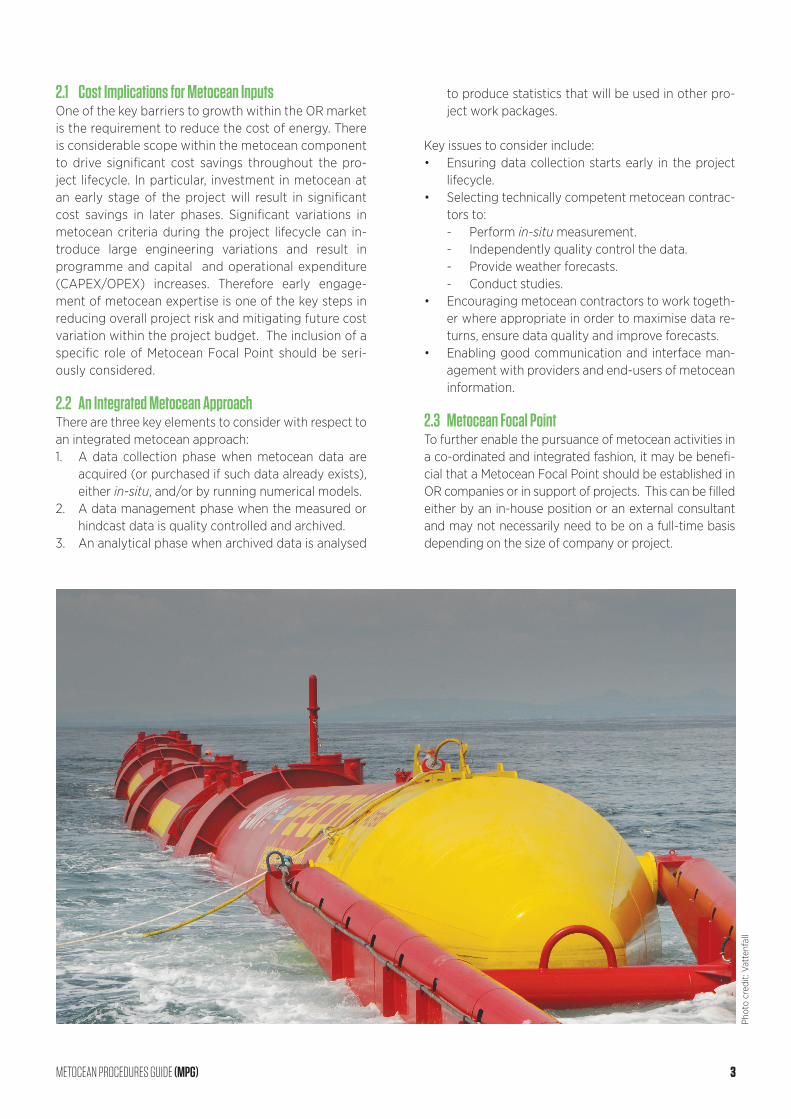
2.1 Cost Implications for Metocean InputsOne of the key barriers to growth within the OR market is the requirement to reduce the cost of energy. There is considerable scope within the metocean component to drive significant cost savings throughout the pro-ject lifecycle. In particular, investment in metocean at an early stage of the project will result in significant cost savings in later phases. Significant variations in metocean criteria during the project lifecycle can in-troduce large engineering variations and result in programme and capital and operational expenditure (CAPEX/OPEX) increases. Therefore early engage-ment of metocean expertise is one of the key steps in reducing overall project risk and mitigating future cost variation within the project budget. The inclusion of a specific role of Metocean Focal Point should be seri-ously considered.
2.2 An Integrated Metocean Approach There are three key elements to consider with respect to an integrated metocean approach:1. A data collection phase when metocean data are
acquired (or purchased if such data already exists), either in-situ, and/or by running numerical models.
2. A data management phase when the measured or hindcast data is quality controlled and archived.
3. An analytical phase when archived data is analysed
to produce statistics that will be used in other pro-ject work packages.
Key issues to consider include:• Ensuring data collection starts early in the project
lifecycle.• Selecting technically competent metocean contrac-
tors to:- Perform in-situ measurement.- Independently quality control the data.- Provide weather forecasts.- Conduct studies.
• Encouraging metocean contractors to work togeth-er where appropriate in order to maximise data re-turns, ensure data quality and improve forecasts.
• Enabling good communication and interface man-agement with providers and end-users of metocean information.
2.3 Metocean Focal PointTo further enable the pursuance of metocean activities in a co-ordinated and integrated fashion, it may be benefi-cial that a Metocean Focal Point should be established in OR companies or in support of projects. This can be filled either by an in-house position or an external consultant and may not necessarily need to be on a full-time basis depending on the size of company or project.
Phot
o cr
edit:
Vat
tenf
all
METOCEAN PROCEDURES GUIDE (MPG) 3
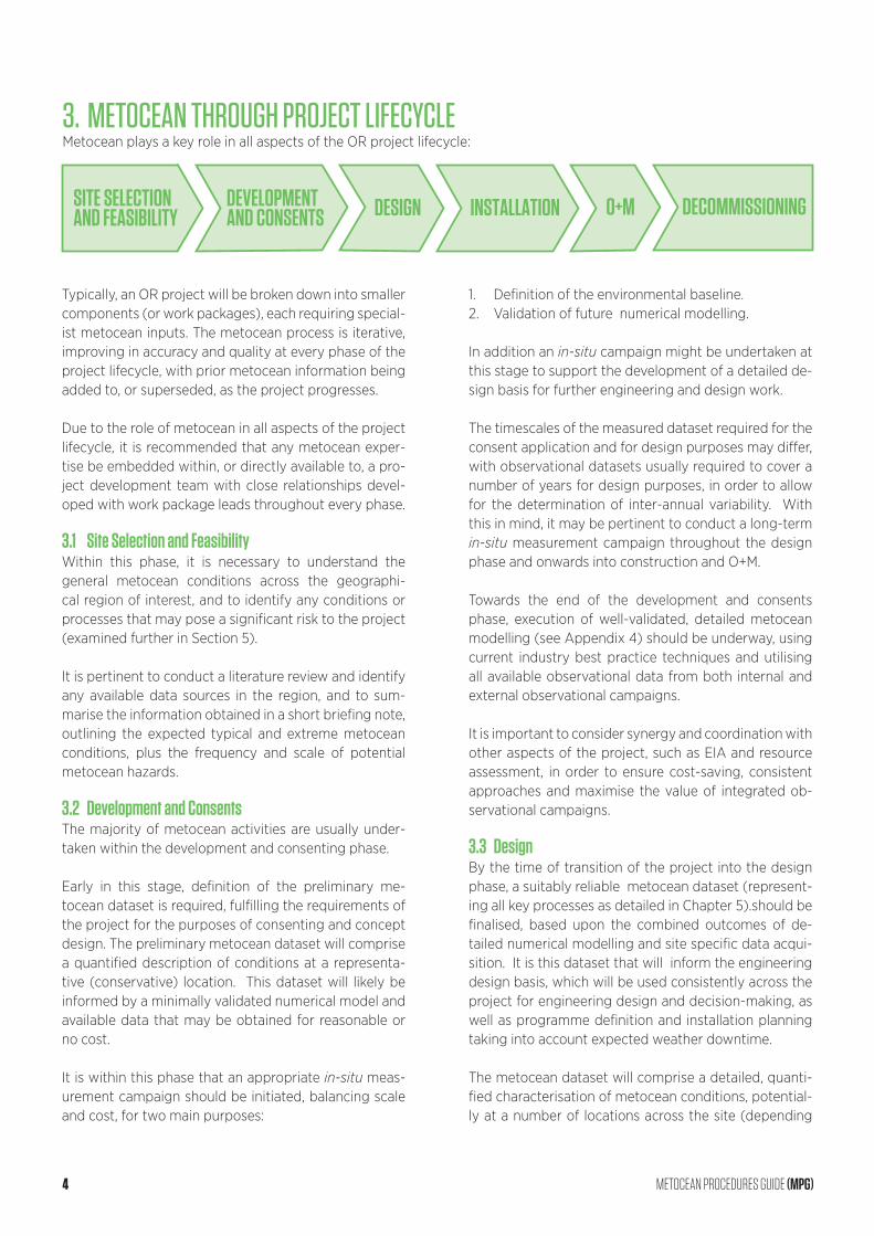
Typically, an OR project will be broken down into smaller components (or work packages), each requiring special-ist metocean inputs. The metocean process is iterative, improving in accuracy and quality at every phase of the project lifecycle, with prior metocean information being added to, or superseded, as the project progresses.
Due to the role of metocean in all aspects of the project lifecycle, it is recommended that any metocean exper-tise be embedded within, or directly available to, a pro-ject development team with close relationships devel-oped with work package leads throughout every phase. 3.1 Site Selection and FeasibilityWithin this phase, it is necessary to understand the general metocean conditions across the geographi-cal region of interest, and to identify any conditions or processes that may pose a significant risk to the project (examined further in Section 5). It is pertinent to conduct a literature review and identify any available data sources in the region, and to sum-marise the information obtained in a short briefing note, outlining the expected typical and extreme metocean conditions, plus the frequency and scale of potential metocean hazards.
3.2 Development and ConsentsThe majority of metocean activities are usually under-taken within the development and consenting phase.
Early in this stage, definition of the preliminary me-tocean dataset is required, fulfilling the requirements of the project for the purposes of consenting and concept design. The preliminary metocean dataset will comprise a quantified description of conditions at a representa-tive (conservative) location. This dataset will likely be informed by a minimally validated numerical model and available data that may be obtained for reasonable or no cost.
It is within this phase that an appropriate in-situ meas-urement campaign should be initiated, balancing scale and cost, for two main purposes:
1. Definition of the environmental baseline.2. Validation of future numerical modelling.
In addition an in-situ campaign might be undertaken at this stage to support the development of a detailed de-sign basis for further engineering and design work.
The timescales of the measured dataset required for the consent application and for design purposes may differ, with observational datasets usually required to cover a number of years for design purposes, in order to allow for the determination of inter-annual variability. With this in mind, it may be pertinent to conduct a long-term in-situ measurement campaign throughout the design phase and onwards into construction and O+M.
Towards the end of the development and consents phase, execution of well-validated, detailed metocean modelling (see Appendix 4) should be underway, using current industry best practice techniques and utilising all available observational data from both internal and external observational campaigns.
It is important to consider synergy and coordination with other aspects of the project, such as EIA and resource assessment, in order to ensure cost-saving, consistent approaches and maximise the value of integrated ob-servational campaigns.
3.3 DesignBy the time of transition of the project into the design phase, a suitably reliable metocean dataset (represent-ing all key processes as detailed in Chapter 5).should be finalised, based upon the combined outcomes of de-tailed numerical modelling and site specific data acqui-sition. It is this dataset that will inform the engineering design basis, which will be used consistently across the project for engineering design and decision-making, as well as programme definition and installation planning taking into account expected weather downtime.
The metocean dataset will comprise a detailed, quanti-fied characterisation of metocean conditions, potential-ly at a number of locations across the site (depending
DEVELOPMENTAND CONSENTS DESIGN INSTALLATION O+M DECOMMISSIONINGSITE SELECTION
AND FEASIBILITY
3. METOCEAN THROUGH PROJECT LIFECYCLEMetocean plays a key role in all aspects of the OR project lifecycle:
4 METOCEAN PROCEDURES GUIDE (MPG)
upon spatial variability) and along the cable corridor. It may be beneficial to continue refining the existing me-tocean data in order to reduce their uncertainty.
3.4 InstallationIn the lead up to the installation phase of the project, it is necessary to procure weather forecasting services for the duration of the offshore installation activities. This should be undertaken in conjunction with real-time monitoring, which may be an extension of the previous metocean measurement campaign. A combined fore-casting and real-time monitoring approach is likely to increase installation efficiency by providing marine per-sonnel with reliable information from which they can make decisions. Additionally, where operations have as-sociated metocean thresholds, real-time data and fore-cast outlook provide the basis upon which the decision to continue operations may be made, for example by a Marine Warranty Surveyor, thereby minimising down-time and reducing risk of compensation claims from contractors.
3.5 Operations and Maintenance (O+M)The O+M phase of a project has similar requirements to that of the installation phase, that is, provision of weather forecasting and real-time data for work plan-ning. In addition operations will also require large scale monitoring, including the continuation of me-tocean measurements, in order to analyse perfor-mance, and understand the impact of localised events so as to revise and adapt the O+M strategy as neces-sary. Furthermore, potential specific modelling require-ments may be required for asset management purpos-es, for example, to complement structural monitoring campaigns. This additional information is beneficial for understanding events leading to damage or failure and the actual conditions endured by the structure for fa-tigue life assessment.
3.6 DecommissioningThe main requirements for decommissioning are provi-sion of hindcast data for programme planning and weath-er forecasting and real-time data for work planning.
4. METOCEAN STANDARDS4.1 GeneralThere have been a number of industry standards and guidance notes released to inform offshore developers of the importance of metocean data, suitable acquisition methods, and analysis to achieve development require-ments. These standards have been issued by organisa-tions such as American Petroleum Institute (API), DNV GL, The International Organization for Standardization (ISO), Norsk Sokkels Konkuranseposisjon (NORSOK), and the International Association of Oil and Gas Produc-ers (OGP). They have, therefore, been created with a fo-cus on deep-water infrastructure installations within the petroleum and natural gas industries.
Whilst the applications of metocean data within the renewable energy industry have been broadly tack-led by Cooper et al. (2008), these were based on the developing UK offshore wind industry during the sec-ond round of offshore renewable development in the UK (Greater Wash, Greater Thames and Irish Sea) and consequently do not adequately address the environ-mental conditions experienced at the offshore wind sites during the Round 3 development, or identified wave and tidal energy sites. Following the publica-tion of Cooper et al (2008), a number of standards relating to the offshore wind industry have now been produced, along with some for the developing marine energy sector.
Furthermore, the International Electrotechnical Com-mission are preparing international standards for marine energy conversion systems, with the primary focus on the conversion of wave, tidal and other water current energy into electrical energy. Specifically relating to me-tocean, the standards produced by Technical Commit-tee (TC) 114 will address resource assessment require-ments, design and survivability; and the evaluation and mitigation of environmental impacts.
4.2 Background to Key DocumentsWhilst a comprehensive list of relevant standards and guidelines are provided within Appendix 2 of this docu-ment, the following provides a brief background to some of the key documents considered to be best practice for application in this sector.
METOCEAN PROCEDURES GUIDE (MPG) 5
DOCUMENT TITLE
DNV OS J101 Design of Offshore Wind Turbine Structures
DNV-OS-C101 Design of Offshore Steel Structures, General (LRFD method).
ISO 19901-1:2005 Petroleum and natural gas industries – Specific requirements for offshore structures Part 1: Metocean design and operating considerations.
NORSOK N-002 Collection of metocean data
OGP 447 Health, Safety and Environmental guidelines for metocean and Arctic surveys
UK Health and Safety Executive document OTR 2001/010 ‘Environmental Considerations’ (HSE, 2002)
DESCRIPTION
A comprehensive offshore standard for the design of wind turbine support structures, including detailed information on metocean requirements (DNV, 2014).
An offshore standard provides principles, technical requirements and guidance for the structural design of offshore structures
Provides general requirements for the determination and use of metocean conditions in the design, construction and operation of offshore structures of all types used in the petroleum and natural gas industries (ISO, 2005). This document is in the process of being updated.
Developed by the Norwegian petroleum industry to present the functional requirements and common principles for the collection of metocean data, and is intended as an initial reference for offshore operators when planning metocean monitoring equipment on offshore installations. The document covers both the statutory requirements and operator’s own requirements, spanning applications including (but not limited to) weather forecasting, climate statistics, helicopter traffic, tanker loading and general marine operations (NORSOK, 2010).
The Norwegian N-002 standard goes beyond ISO 19901-1 in that it provides a recommended instrument accuracy and typical operation performance for a variety of metocean variables including temperature, humidity, atmospheric pressure, cloud, wind, visibility, wave, ocean current, water level, temperature profile, salinity profile and dissolved oxygen.
Details health, safety and environmental guidelines for carrying out metocean measurement campaigns (OGP, 2011).
This document is only a re-issue of the previous 1990 edition of the ‘Department of Energy Guidance Notes’. It has not been updated with the latest technical informa-tion and should therefore be used with caution. In this respect the other standards mentioned above take precedence.
6 METOCEAN PROCEDURES GUIDE (MPG)
5. METOCEAN DATA SOURCES AND MANAGEMENT
The required level of accuracy, and therefore cost, of metocean data evolves with the project. Public data are often available, and can be used to provide a prelimi-nary characterisation of metocean conditions on site. At this early stage, inherent uncertainties and limitations of the data should be acknowledged, and where possible the potential implications understood and interpreted if relevant. As the project progresses and the design is re-fined, more accurate statistics are required. This enables increased certainty in the design basis.
5.1 Data SourcesThere are three fundamental sources of metocean data obtained by:• In-situ measurement.• Numerical modelling.• Satellite observations.
These are subjected to various analyses to produce a range of statistics and deliverables suitable for engi-neering applications. Within the context of metocean data gathering, a fourth effective type of metocean data may be added:• Statistics from pre-existing proprietary reports or
publications.
Some of these data can be obtained from public domain sources, or collaboration with other operators with in-terests in the region. However, an offshore development usually requires, and directly benefits from, a dedicated site-specific data collection effort. A suitable metocean database usually includes all of the above.
In-situ measurement provides reliable quantification of conditions at a specific site during the instrumentation deployment period, but usually of much too short a du-ration for reliable quantification of long-term trends and statistics.
Numerical models provide the required longer term context, but require validation and calibration using in-situ measurement or satellite observations.
Numerical models and satellite observations both pro-vide valuable spatial coverage, well beyond a limited set of in-situ measurement sites, but have limitations in terms of temporal and spatial resolution.
As such, a good metocean database is the result of careful combination of different data sources. Further
details on data collection and numerical modelling are provided in Appendices 3 and 4 respectively.
5.2 Metocean ProcessesSelected data sources must represent the key metocean processes that impact the development site. These pro-cesses vary considerably from region to region.
Examples of key processes affecting extreme and op-erating conditions within the extensively studied North Sea include:• Winds forced by atmospheric disturbances, notably
mid-latitude storms.• Wind-sea waves generated by the local near surface
wind field.• Swell waves generated by remote near surface wind
field.• Tidal currents and water level driven by predictable
astronomical forcing.• Surge currents and water level driven by less pre-
dictable atmospheric disturbances.
The spatial and temporal resolution of selected datasets must be sufficient to resolve the dominant metocean processes. For the examples given for the North Sea, time intervals between 3 hours and 10 minutes will generally suffice. However, more frequent sampling is required to capture the small scale, rapidly varying processes that dominate in other regions (for example, turbulence, solitons and squalls).
Although OR projects need site-specific (and possibly technology specific) information, a general understanding of the broader metocean conditions in a region is useful. These can be found in the regional annexes of ISO (2005).Metocean processes control all key metocean param-eters, including those relating to wind, wave, current and water level. A summary of specific parameters un-der each of these categories is given in the Glossary of Terms (Appendix 2).
5.3 Data Management Metocean data is a valuable resource which needs to be managed through application of quality control and ar-chiving processes. This subsequently establishes a long-term database which can be accessed and implemented by a number of stakeholders for a number of wide-rang-ing applications. Recent technological developments and refined scientific requirements have meant that survey data packages (both in-situ measured and modelled) are increasing in size. Terabytes of data should therefore be expected, which have associated impacts on the tech-nology and infrastructure required to suitably undertake data processing, analysis and management.
METOCEAN PROCEDURES GUIDE (MPG) 7
There are a number of marine data management schemes being developed and implemented at a range of spatial scales. The International Council for the Exploration of the Sea (ICES) is a global collabo-rative effort with a well-established data centre man-aging large marine environmental datasets. European efforts include the European Global Ocean Observ-ing System (EuroGOOS) and the European Marine Observation and Data Network (EMODnet), where EMODnet’s physics portal has been developed to provide access to physical data sets made available from partner countries in addition to the array of data available via EuroGOOS.
In order to promote the sharing of, and improved ac-cess to, collected marine environmental data at a na-tional level, and specifically for the UK, the Marine En-vironmental Data and Information Network (MEDIN) has been created. Associated with MEDIN, individual Data Archive Centres (DACs) have been established for discrete scientific areas to provide secure, long-term storage and provide access to marine data. The use of MEDIN also complies with the INSPIRE1 Di-rective for consenting purposes. Specifically related to the metocean technical area, the UK Met Office is the DAC responsible for marine meteorological data, making it available via a number of separate facilities. The British Oceanographic Data Centre (BODC) is the DAC responsible for hosting marine biological, chemi-cal, physical and geophysical data. Other equivalent
organisations apply in other parts of the world, not specified in this document.
Due to the number of potential users of the data, it is essential to create an environment which promotes easy access and use of data, and ensures that datasets are described in a consistent way. For this purpose, marine data standards including the use of standardised field names and controlled vocabularies have been estab-lished by MEDIN.
5.4 Metocean ContractorsMetocean activities can be broadly classified into five categories with respect to services offered by metocean contractors:1. In-situ measurement.2. Numerical hindcast modelling.3. Numerical forecast modelling.4. Satellite observations.5. Data analysis and desktop studies.
Some contractors offer a comprehensive service cover-ing all categories whereas others occupy specific niches. It is important to ensure that, in choosing contractors, due account is taken of their relevant competency, ex-perience, reputation, health and safety record and qual-ity assurance system.
As part of the contracting process it is imperative to have a clearly defined, fit-for-purpose scope of work. This should be developed by the Metocean Focal Point in conjunction with the project team. Further discussion regarding the scope of work for observational and modelling campaigns can be found in Appendix 3 and 4 respectively.
1 Directive 2007/2/EC of the European Parliament and of the Council of 14 March 2007 establishing an Infrastructure for Spatial Information in the European Community (INSPIRE)
8 METOCEAN PROCEDURES GUIDE (MPG)
6. METOCEAN STRATEGYPrevious parts of this document introduced the impor-tance of a co-ordinated and integrated approach to me-tocean activities. This section outlines a recommended strategy to be adopted to ensure that metocean deci-sions, requirements and products appropriate to an OR project are delivered throughout its lifecycle.
As noted in the introduction, this procedures guide is fo-cussed on offshore wind developments involving a fixed structure, due to relative technical maturity. Many of the general principles will also apply to floating wind, wave and tidal. However, some specific details will differ.
For floating wind energy and wave energy, a major dif-ference from a metocean perspective will be the charac-terisation of metocean conditions required to quantify impact upon a floating structure, which reacts dynami-cally to its environment. For example, it is necessary to characterise details of the full directional wave spectra. A major challenge is designing for platform motion with corresponding motion of the wind turbine blades, or electrical power take-off in the case of wave energy.
With regard to tidal energy, one major difference will be the need to characterise ocean turbulence. This is analo-gous to the need to characterise atmospheric turbulence for wind turbine engineering, but may bring specific new challenges to the data collection strategy. Potential tidal energy development sites are necessarily in regions of strong tidal flow, which are often highly turbulent. There are presently no established standards for characterisa-tion of ocean turbulence for current turbine engineering.
A recommended approach for the delivery of the me-tocean strategy is structured in terms of key deliverables outlined in Sections 6.1 - 6.4 below, and summarised in a Gantt chart shown in Section 6.5.
6.1 Briefing Note In the early phases of site selection and feasibility, a metocean briefing note is required and would typically include:• General description of the proposed site.• Summary of available data sources and data gap
analysis.• Identification of potential hazards (for example,
wave breaking, scour, hurricanes, bi-modal sea state, and sediment movement).
• Approximation of wind, wave, current and water level (operational, extreme and weather downtime).
The briefing note should identify the conditions that may prevent the technical feasibility and economic vi-ability of a potential project. If a specific risk is identi-fied, it may be that further investigation is required at an early stage of the project.
6.2 Preliminary Data and AnalysesAs an OR project progresses into development and consenting and early design, a preliminary engineering dataset and selected analyses will be required. This pro-vides a best estimate of metocean conditions based on available measured data or coarse, uncalibrated, unvali-dated model data if insufficient measured data is avail-able. It will generally include:• Quantified description of conditions at a represent-
ative (conservative) location or locations. • Quantification of potential hazards, leading to as-
sessment of associated risk.• Concurrent time series of wind, wave, current and
water level from which to derive a range of opera-tional, extreme and weather downtime statistics.
Metocean data and analyses will also contribute to other aspects of the project, such as definition of the environ-mental baseline and impact studies regarding founda-tion impact on metocean regime, scour, sediment dis-persion due to piling, seabed preparation or cable burial.
Requirements for this dataset will be project specific as a combined consequence of site conditions, project defini-tion, project team and the methodologies used for prelimi-nary design. It is therefore recommended that the detailed content of the preliminary engineering data and analyses be defined in coordination with the project team.
6.3 Full Data and AnalysesThe full dataset will comprise a high quality, accurate ac-count of metocean conditions from detailed modelling validated against in-situ measurements, taking account of spatial variability, including:• Quantified description of conditions at a number of
locations depending on spatial variability.• Statistical analyses, including operational extremes
and weather downtime.• Additional specialist analyses as required by project
teams.
Metocean will also contribute to detailed quantification of identified high-risk hazards, such as scour.
The full dataset and analyses will be required as soon as is practicably possible within the design phase and will form the basis of engineering design and installation planning.
METOCEAN PROCEDURES GUIDE (MPG) 9
6.4 Other Products and AnalysesFrom the construction of the project up to its decom-missioning, additional metocean inputs and analyses may be required by project activities, such as:• Weather forecasting.• Real-time in-situ measurement.• Weather downtime planning.• Performance evaluation.• Condition monitoring.• O+M strategy optimisation.
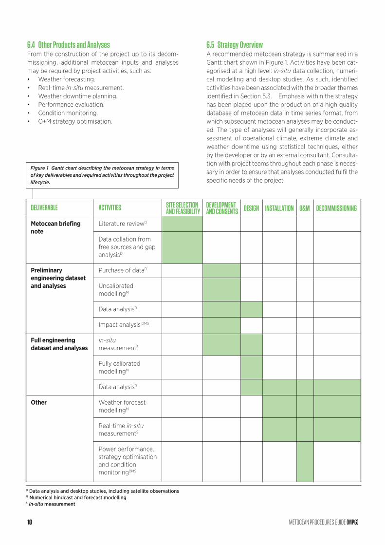
6.5 Strategy OverviewA recommended metocean strategy is summarised in a Gantt chart shown in Figure 1. Activities have been cat-egorised at a high level: in-situ data collection, numeri-cal modelling and desktop studies. As such, identified activities have been associated with the broader themes identified in Section 5.3. Emphasis within the strategy has been placed upon the production of a high quality database of metocean data in time series format, from which subsequent metocean analyses may be conduct-ed. The type of analyses will generally incorporate as-sessment of operational climate, extreme climate and weather downtime using statistical techniques, either by the developer or by an external consultant. Consulta-tion with project teams throughout each phase is neces-sary in order to ensure that analyses conducted fulfil the specific needs of the project.
DELIVERABLE
Metocean briefing note
Preliminary engineering dataset and analyses
Full engineering dataset and analyses
Other
ACTIVITIES
Literature reviewD
Data collation from free sources and gap analysisD
Purchase of dataD
Uncalibrated modellingM
Data analysisD
Impact analysis DMS
In-situ measurementS
Fully calibrated modellingM
Data analysisD
Weather forecast modellingM
Real-time in-situ measurementS
Power performance, strategy optimisation and condition monitoringDMS
SITE SELECTION DEVELOPMENT DESIGN INSTALLATION O&M DECOMMISSIONING AND FEASIBILITY AND CONSENTS
D Data analysis and desktop studies, including satellite observations M Numerical hindcast and forecast modelling S In-situ measurement
Figure 1 Gantt chart describing the metocean strategy in terms of key deliverables and required activities throughout the project lifecycle.
10 METOCEAN PROCEDURES GUIDE (MPG)
7. REFERENCESDNV, 2014. Offshore Standard DNV-OS-J101: Design of Offshore Wind Turbine Structures, Det Norske Veritas.
HSE, 2002. Offshore Technology Report 2001/010: Envi-ronmental Considerations, Health and Safety Executive.
ISO, 2005. ISO19901-1:2005 Petroleum and natural gas industries – Specific requirements for offshore struc-tures – Part 1: Metocean design and operating consid-erations, International Organisation for Standardisation.
NORSOK, 2010. NORSOK Standard N-002: Collection of metocean data, Edition 2 (October 2010), Norsk Sokkels Konkuranseposisjon.
OGP, 2011. Health, Safety and Environmental guidelines for metocean and Arctic surveys, Report No. 477, Inter-national Association of Oil and Gas Producers.
APPENDIX 1 – STANDARDSA1.1 Oil and Gas• DNV, 2010. Recommended Practice DNV-RP-C205:
Environmental Conditions and Environmental Loads.
• DNV, 2011. Offshore Standard DNV-OS-H101: Marine Operations (General).
• International Organisation for Standardisation, 2005. ISO 19901-1:2005 Petroleum and natural gas industries – Specific requirements for offshore structures – Part 1: Metocean design and operating considerations.
• Norsk Sokkels Konkuranseposisjon, 2010. NORSOK Standard N-002: Collection of metocean data, Edi-tion 2 (October 2010).
• International Association of Oil and Gas Producers, 2011. Health, Safety and Environmental guidelines for metocean and Arctic surveys, Report No. 477.
A1.2 Renewable Energy• Cooper, W., Saulter, A., and Hodgetts, P., 2008.
Guidelines for the use of metocean data through the life cycle of a marine renewable energy devel-opment, CIRIA (London).
• DNV, 2013. Offshore Standard DNV-OS-J103: Design of Floating Wind Turbine Structures.
• European Marine Energy Centre, 2009. Marine Re-newable Energy Guides (drafts),:- Assessment of Wave Energy Resource*- Assessment of Tidal Energy Resource*- Guidelines for Health and Safety in the Marine
Energy Industry- Guidelines for Marine Energy Converter Certifi-
cation Schemes- Guidelines for Design Basis of Marine Energy
Conversion Systems*- Guidelines for Reliability, Maintainability and Sur-
vivability of Marine Energy Conversion Systems- Guidelines for Grid Connection of Marine En-
ergy Conversion Systems- Tank Testing of Wave Energy Conversion Systems*- Guidelines for Project Development in the Ma-
rine Energy Industry- Guidelines for Manufacturing, Assembly and
Testing of Marine Energy Conversion Systems• International Electrotechnical Commission, 2009.
IEC 61400-3:2009 Design requirements for offshore wind turbines.- IEC 61400-3-2 Design requirements for floating
offshore wind turbines, International Electro-technical Commission.
• International Electrotechnical Commission, 2013.
METOCEAN PROCEDURES GUIDE (MPG) 11
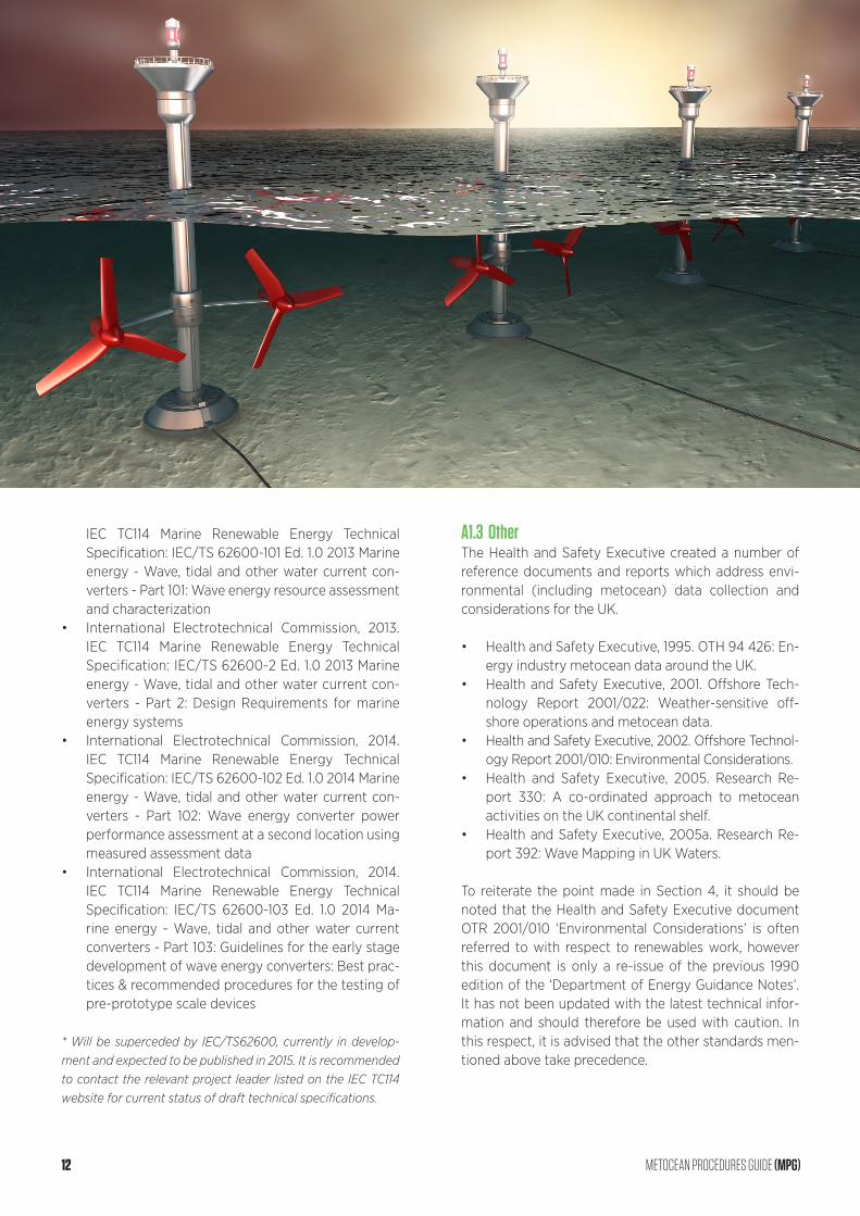
IEC TC114 Marine Renewable Energy Technical Specification: IEC/TS 62600-101 Ed. 1.0 2013 Marine energy - Wave, tidal and other water current con-verters - Part 101: Wave energy resource assessment and characterization
• International Electrotechnical Commission, 2013. IEC TC114 Marine Renewable Energy Technical Specification: IEC/TS 62600-2 Ed. 1.0 2013 Marine energy - Wave, tidal and other water current con-verters - Part 2: Design Requirements for marine energy systems
• International Electrotechnical Commission, 2014. IEC TC114 Marine Renewable Energy Technical Specification: IEC/TS 62600-102 Ed. 1.0 2014 Marine energy - Wave, tidal and other water current con-verters - Part 102: Wave energy converter power performance assessment at a second location using measured assessment data
• International Electrotechnical Commission, 2014. IEC TC114 Marine Renewable Energy Technical Specification: IEC/TS 62600-103 Ed. 1.0 2014 Ma-rine energy - Wave, tidal and other water current converters - Part 103: Guidelines for the early stage development of wave energy converters: Best prac-tices & recommended procedures for the testing of pre-prototype scale devices
* Will be superceded by IEC/TS62600, currently in develop-ment and expected to be published in 2015. It is recommended to contact the relevant project leader listed on the IEC TC114 website for current status of draft technical specifications.
A1.3 OtherThe Health and Safety Executive created a number of reference documents and reports which address envi-ronmental (including metocean) data collection and considerations for the UK.
• Health and Safety Executive, 1995. OTH 94 426: En-ergy industry metocean data around the UK.
• Health and Safety Executive, 2001. Offshore Tech-nology Report 2001/022: Weather-sensitive off-shore operations and metocean data.
• Health and Safety Executive, 2002. Offshore Technol-ogy Report 2001/010: Environmental Considerations.
• Health and Safety Executive, 2005. Research Re-port 330: A co-ordinated approach to metocean activities on the UK continental shelf.
• Health and Safety Executive, 2005a. Research Re-port 392: Wave Mapping in UK Waters.
To reiterate the point made in Section 4, it should be noted that the Health and Safety Executive document OTR 2001/010 ‘Environmental Considerations’ is often referred to with respect to renewables work, however this document is only a re-issue of the previous 1990 edition of the ‘Department of Energy Guidance Notes’. It has not been updated with the latest technical infor-mation and should therefore be used with caution. In this respect, it is advised that the other standards men-tioned above take precedence.
12 METOCEAN PROCEDURES GUIDE (MPG)
APPENDIX 2 - GLOSSARYA2.1 GeneralAnalyses Statistical analysis of selected datasets to produce in-formation or products, for example, design criteria or weather downtime.
DataIndividual measurements or model outputs at discrete timesteps, for example, hourly.
Dataset (or time series)A record of parameters at discrete timesteps for a given time period, for example, 2 years of observational wave data or 40 years of hindcast wave data. This time series of data is the basis for all statistical analyses.
Design criteriaA statement of the worst-case (or extreme) metocean conditions that a structure or vessel must be designed to withstand.
ExtremesThe worst case metocean conditions expected, derived from statistical extreme value analysis. Usually stated in association with a return period and probability of occurrence.
ForecastTypically described as numerical modelling of a future pe-riod informed by skilled forecasters using a variety of guid-ance data such as in-situ or satellite measurements. Due to the chaotic nature of atmospheric and oceanographic con-ditions, forecasts are generally constrained to a 7-10 day period ahead. The reliability of the forecast is dependent on the forecast horizon and synoptic situation.
HindcastNumerical modelling of a historical period. Hindcast techniques allow a numerical wave, current or wind model to be verified against available observations, thereby improving accuracy and reliability and allowing the production of long-term time series of data.
In-situ measurementMeasurement or observation of real metocean condi-tions at a specific location.
MetoceanA technical engineering discipline that addresses meteorological and physical oceanographic matters, originating from the oil and gas sector in the late
1970’s and equally applicable to the offshore renewa-bles sector.
Metocean processesAll-encompassing term for the physical processes gov-erning the metocean regime that vary from region to region, such as tides, ocean circulation or atmospheric phenomena.
Mid-latitude stormSynoptic scale low pressure weather systems occurring at mid-latitudes.
Numerical modellingComputer simulation of the known dynamics of the real world.
Operational limitsThe metocean conditions up to which an activity can be performed, for example, significant wave height < 1.5m.
Return period The duration (in years) within which an extreme value is expected to be equalled or exceeded once, for example, once in 1, 10, 50 or 100 years.
Satellite ObservationData derived from satellite altimeter or scatterometer observations.
SolitonsSolitary wave packets associated with local density vari-ations, causing localised short-term increases in currents.
Spatial resolutionThe spacing of model grid points or observations, for example, 1m, 100m, 3km or 1 degree.
SquallA sudden sharp increase in wind speed resulting from localised events such as thunderstorms.
Temporal resolutionThe frequency of measurements or model output in time, for example, 1 second, 1 minute, 10 minutes or 1 hour.
TurbulenceDisturbed, semi-random motion of air or water particles, occurring where flow interacts with a structure.
Weather downtimePeriods when offshore operations must be suspended due to adverse weather conditions, due to the exceed-ance of operational limits.
METOCEAN PROCEDURES GUIDE (MPG) 13
Weather windowThe minimum time period within an operational limit required to perform a given installation or mainte-nance activity, for example, significant wave height <1.5m for a weather window of 6 hours.
A2.2 WindWind speed and directionThe sustained wind speed over a given period at a given height above the sea surface (typically 10 metres) and associated direction, usually expressed as follows:• 1 hour mean – mean wind speed measured over 1
hour• 10 minute mean – mean wind speed measured over
10 minutes• 1 minute mean – mean wind speed measured over 1
minute• 3 second gust – maximum value of wind speed over
3 seconds
A2.3 WaveMaximum individual wave heightThe highest individual wave crest to trough excursion in a wave sample.
Mean zero-crossing periodThe average period between successive (up or down) crossings of waves in a sea state.
Peak periodThe period corresponding to the frequency where the spectral density (see below) reaches its maximum.
Sea (or wind-sea)Component of the sea state related to locally generated wind.
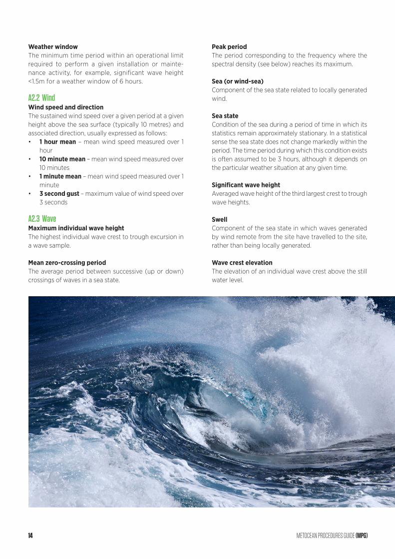
Sea stateCondition of the sea during a period of time in which its statistics remain approximately stationary. In a statistical sense the sea state does not change markedly within the period. The time period during which this condition exists is often assumed to be 3 hours, although it depends on the particular weather situation at any given time.
Significant wave heightAveraged wave height of the third largest crest to trough wave heights.
SwellComponent of the sea state in which waves generated by wind remote from the site have travelled to the site, rather than being locally generated.
Wave crest elevationThe elevation of an individual wave crest above the still water level.
14 METOCEAN PROCEDURES GUIDE (MPG)
Wave directionThe direction from which a wave propagates.
Wave spectrumThe wave spectrum or spectral density describes how the variance of the sea surface elevation is distributed over frequency and propagation direction, from which all wave parameters may be derived.
A2.4 CurrentResidual currentResidual currents are caused by a variety of physical mechanisms and comprise a large range of natural frequencies and magnitudes in different parts of the world. The residual current is the part of the total current that is not constituted from harmonic tidal components.
Tidal currentTidal current is the part of the total current related to the astronomical forcing alone. As a result, tidal currents are predictable, with accuracy increased by analysis of the total current against increased numbers of harmonic constituents.
Total currentThe combination of tidal and residual currents makes up the total current which is the resulting (primarily) hori-zontal flow of water experienced.
A2.5 Water LevelsAmphidromic pointA location where the tidal range is zero.
Chart datumThe level of water that charted depths displayed on a nautical chart are measured from. A chart datum is gen-erally a tidal datum, typically mean sea level or lowest astronomical tide.
Extreme water level (EWL)An engineering abstraction calculated by combining wave crest elevation, tide and surge. EWL is important in helping to determine the height of deck elevations above LAT or MSL on offshore structures. Note that oth-er factors such as water depth uncertainty and seabed subsidence should be considered when determining deck elevations.
Still water level (SWL)An engineering abstraction calculated by adding the ef-fects of tides and storm surge to the water depth, but excluding variations due to waves. It can be above or below mean sea level.
SurgeThe change in sea level (either positive or negative) that is due to meteorological (rather than tidal) forcing.
Tidal levelsA range of different levels related to the various daily, monthly, annual and decadal astronomical cycles:• HAT – the highest level of tide which occurs once
every 18.6 years• MHWS – mean high water springs• MHWN – mean high water neaps• MSL – mean sea level• MLWN – mean low water neaps• MLWS – mean low water springs• LAT – the lowest level of tide which occurs once
every 18.6 years
Tidal rangeEither the vertical difference between a high tide and the succeeding low tide, or HAT and LAT.
Water depth Vertical distance between the sea floor and a designat-ed datum, typically LAT or MSL.
A2.6 Units and Convention• Units are expressed using the Standard Internation-
al (SI) convention:- Distance (wave height, surface elevation and
water depth) in metres- Time (wave periods) in seconds- Velocity (wind or current speed) in metres per
second• Wave and wind direction is expressed as ‘coming
from’ in nautical degrees, i.e. degrees relative to true north positive clockwise.
• Current direction if expressed as ‘going to’ in nauti-cal degrees, i.e. degrees relative to true north posi-tive clockwise.
METOCEAN PROCEDURES GUIDE (MPG) 15
APPENDIX 3 – IN-SITU DATA COLLECTIONThe start of any metocean data collection is deter-mined on a project-specific basis, but it will generally be initiated at the beginning of the development and consent phase, with consultation between the project teams. When making a decision with regards to the commencement of a measurement campaign, strong consideration should be given to the entire project programme, taking into account the desire for long-term on-site measurements
A3.1 Scope of WorksThere are many issues to address with respect to a data collection programme:• Ensure data collection starts early enough to collect
sufficient data (normally at least 1-2 years for devel-opment needs and preferably longer to ensure vali-dation of design criteria, depending on availability of other data).
• Consider the benefits of real-time access to data for monitoring and quality control purposes.
• Ensure data are quality controlled on a monthly or quarterly basis, or as and when data becomes avail-able.
• Consider data archiving options, i.e. in-house or with a contractor.
• Consider continuation of data collection into the op-erational phase of any development to provide in-formation for maintenance activities and to improve future statistical analyses.
• Consider use of a weather forecast service to assist with deployment and recovery phases.
A long-term metocean measurement campaign is en-couraged, covering the development and design phase of the project, and maintained throughout construction and O+M phases in order to support forecasting with real-time data.
The metocean measurement campaign should com-prise, as a minimum, measurement of wave, water level and current conditions, unless long-term in-situ data are already available at the site.
It is usually cost-effective to simultaneously collect ad-ditional environmental monitoring data, including but not limited to:• Seabed samples, water samples and a time series
of suspended sediment concentrations to support impact studies.
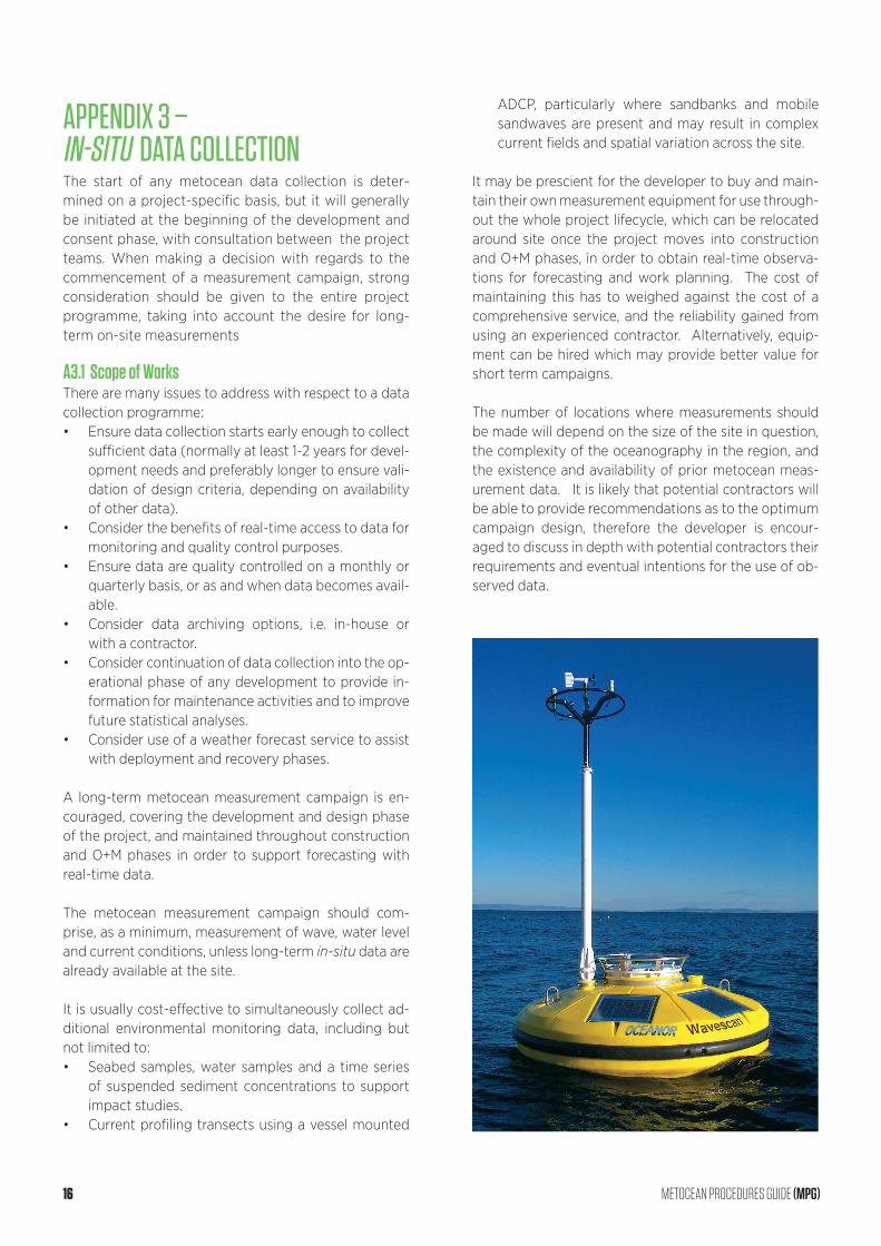
• Current profiling transects using a vessel mounted
ADCP, particularly where sandbanks and mobile sandwaves are present and may result in complex current fields and spatial variation across the site.
It may be prescient for the developer to buy and main-tain their own measurement equipment for use through-out the whole project lifecycle, which can be relocated around site once the project moves into construction and O+M phases, in order to obtain real-time observa-tions for forecasting and work planning. The cost of maintaining this has to weighed against the cost of a comprehensive service, and the reliability gained from using an experienced contractor. Alternatively, equip-ment can be hired which may provide better value for short term campaigns.
The number of locations where measurements should be made will depend on the size of the site in question, the complexity of the oceanography in the region, and the existence and availability of prior metocean meas-urement data. It is likely that potential contractors will be able to provide recommendations as to the optimum campaign design, therefore the developer is encour-aged to discuss in depth with potential contractors their requirements and eventual intentions for the use of ob-served data.
16 METOCEAN PROCEDURES GUIDE (MPG)

A3.2 ScheduleIt is pertinent to consider the scheduling of a metocean data collection campaign in order to ensure the best op-portunity for gathering information on extreme events, however, deployment of metocean equipment mid-winter is ill-advised. Developers should initiate procure-ment of contracted services in good time to ensure de-ployment by, for example, the end of summer for 1-year campaigns, taking into consideration the likelihood of vessel schedules having been set well in advance. Lead-times for the contracting and deployment of metocean equipment will vary from company to company, and developers should initiate contracting in a timely man-ner to allow for the full tendering process, acquisition of necessary licences and future availability of potential contractors.
The possibility for alignment with other measurement campaigns (for example, those requiring installation of meteorological masts or fixed or floating LiDAR) within the project should also be considered. Where possible, it is recommended that metocean data is collected along-side other measurement campaigns, in order that the full dynamics of a site can be captured concurrently. However, factors such as lead time and cost of concur-rent deployment must also be allowed for.
A3.3 Data and Equipment LossConsideration must be given to the level of data loss deemed acceptable by the developer. Data loss can be mitigated by real-time transmission of data, or by re-dundancy in the measurement strategy.
It should be noted that the deployment of metocean equipment may require licencing from relevant national bodies and is likely to include, for example, the issue of a Notice to Mariners. In some locations, it may be nec-essary to request an addition to navigational charts and, for busy shipping areas, the use of higher grade guard buoys should be considered. Additionally, in areas of in-tense fishing activity, it may be beneficial to contract a lo-cal Fisheries Liaison Organisation to assist in the engage-ment of the industry and distribution of information.
Assessing the risk to third parties of installed equipment is extremely important. In addition, assessing the risk to the equipment from shipping and other activities such as trawling, is key to the execution of a successful meas-urement campaign. Metocean measurement campaigns often experience issues such as collisions with vessels and technology failure, so it is important to ensure that any contract incorporates risk management and emer-gency response in order to rectify issues and minimise loss of data.
A3.4 Data SpecificationIt is recommended that raw, as well as processed data, be obtained from the contractor. A metocean measure-ment campaign will generally result in large amounts of raw data. It is necessary to plan in advance how and where data will be stored and archived, how it will be accessed, and to ensure adequate quality control meth-odologies.
A3.5 Health, Safety and EnvironmentThe execution of a metocean measurement campaign involves offshore working and therefore has implica-tions in terms of Health and Safety. Personnel to be used in offshore operations should possess the correct cer-tification (offshore survival training and medical), with vessels checked for their suitability to the task and com-pliance with health and safety. It is recommended that the relevant guidelines be consulted, such as the project Health, Safety and Environment guidelines (see Section 4 and Appendix 2).
A3.6 Measurement Campaign Specification SheetWhen designing a metocean measurement campaign, a number of elements need to be defined within the Scope of Works. In order to aid in the definition of an appropriate campaign and assist in deliberations with potential contractors, a Measurement Campaign Specification Sheet is provided in Figure 2. A complet-ed example for the design of a current measurement campaign is provided in Figure 3. The sheet should be modified to reflect the specific project requirements in any given case.
METOCEAN PROCEDURES GUIDE (MPG) 17

REVISION NUMBER
HSE Plan
Parameters required
Intended use of data
Deployment duration
Device type and number required
Locations
Sampling depths
Sampling interval
Data specification
Servicing interval
Final report
Interim reports
Deployment reports
Emergency response reports
Data Delivery: Real Time
Data Delivery: Raw and processed archive
DATE
A full HSE plan is required for all offshore works
Define parameters required
Define onward use of data (design criteria, operational support)
Define how many months data should be collected and start date
Define preferred device of known, and number of locations
Define locations for deployment
Define levels (relative to seabed OR surface) that data is required.
Define sampling frequency
Define the specification to be used
If required define servicing interval
Define report requirements in detail
Is interim reporting required? When?
Are deployment reports required?
Are emergency response reports required?
Yes/no? If yes then define where require.
Raw and/or processed data archive required and spec
MEASUREMENT CAMPAIGN SPECIFICATION SHEET: [PROJECT NAME]
DATA COLLECTION TYPE: [DATA TYPE]
APPROVED
Figure 2 Measurement Campaign Specification Sheet – blank
18 METOCEAN PROCEDURES GUIDE (MPG)
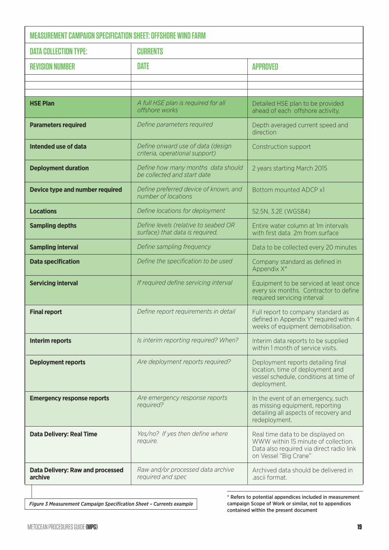
REVISION NUMBER
HSE Plan
Parameters required
Intended use of data
Deployment duration
Device type and number required
Locations
Sampling depths
Sampling interval
Data specification
Servicing interval
Final report
Interim reports
Deployment reports
Emergency response reports
Data Delivery: Real Time
Data Delivery: Raw and processed archive
DATE
A full HSE plan is required for all offshore works
Define parameters required
Define onward use of data (design criteria, operational support)
Define how many months data should be collected and start date
Define preferred device of known, and number of locations
Define locations for deployment
Define levels (relative to seabed OR surface) that data is required.
Define sampling frequency
Define the specification to be used
If required define servicing interval
Define report requirements in detail
Is interim reporting required? When?
Are deployment reports required?
Are emergency response reports required?
Yes/no? If yes then define where require.
Raw and/or processed data archive required and spec
MEASUREMENT CAMPAIGN SPECIFICATION SHEET: OFFSHORE WIND FARM
DATA COLLECTION TYPE: CURRENTS
APPROVED
Detailed HSE plan to be provided ahead of each offshore activity.
Depth averaged current speed and direction
Construction support
2 years starting March 2015
Bottom mounted ADCP x1
52.5N, 3.2E (WGS84)
Entire water column at 1m intervals with first data 2m from surface
Data to be collected every 20 minutes
Company standard as defined in Appendix X*
Equipment to be serviced at least once every six months. Contractor to define required servicing interval
Full report to company standard as defined in Appendix Y* required within 4 weeks of equipment demobilisation. Interim data reports to be supplied within 1 month of service visits.
Deployment reports detailing final location, time of deployment and vessel schedule, conditions at time of deployment.
In the event of an emergency, such as missing equipment, reporting detailing all aspects of recovery and redeployment.
Real time data to be displayed on WWW within 15 minute of collection. Data also required via direct radio link on Vessel “Big Crane”
Archived data should be delivered in .ascii format.
Figure 3 Measurement Campaign Specification Sheet – Currents example* Refers to potential appendices included in measurement campaign Scope of Work or similar, not to appendices contained within the present document
METOCEAN PROCEDURES GUIDE (MPG) 19
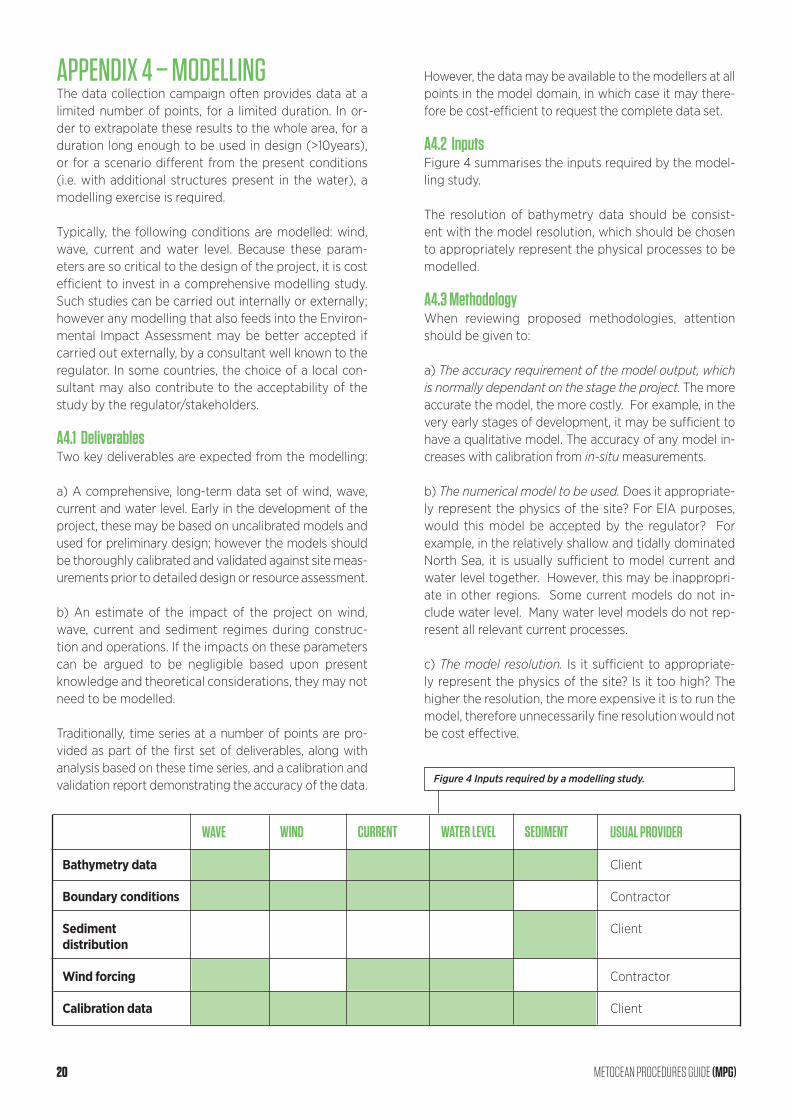
APPENDIX 4 – MODELLINGThe data collection campaign often provides data at a limited number of points, for a limited duration. In or-der to extrapolate these results to the whole area, for a duration long enough to be used in design (>10years), or for a scenario different from the present conditions (i.e. with additional structures present in the water), a modelling exercise is required.
Typically, the following conditions are modelled: wind, wave, current and water level. Because these param-eters are so critical to the design of the project, it is cost efficient to invest in a comprehensive modelling study. Such studies can be carried out internally or externally; however any modelling that also feeds into the Environ-mental Impact Assessment may be better accepted if carried out externally, by a consultant well known to the regulator. In some countries, the choice of a local con-sultant may also contribute to the acceptability of the study by the regulator/stakeholders.
A4.1 DeliverablesTwo key deliverables are expected from the modelling:
a) A comprehensive, long-term data set of wind, wave, current and water level. Early in the development of the project, these may be based on uncalibrated models and used for preliminary design; however the models should be thoroughly calibrated and validated against site meas-urements prior to detailed design or resource assessment.
b) An estimate of the impact of the project on wind, wave, current and sediment regimes during construc-tion and operations. If the impacts on these parameters can be argued to be negligible based upon present knowledge and theoretical considerations, they may not need to be modelled.
Traditionally, time series at a number of points are pro-vided as part of the first set of deliverables, along with analysis based on these time series, and a calibration and validation report demonstrating the accuracy of the data.
However, the data may be available to the modellers at all points in the model domain, in which case it may there-fore be cost-efficient to request the complete data set.
A4.2 InputsFigure 4 summarises the inputs required by the model-ling study.
The resolution of bathymetry data should be consist-ent with the model resolution, which should be chosen to appropriately represent the physical processes to be modelled.
A4.3 MethodologyWhen reviewing proposed methodologies, attention should be given to:
a) The accuracy requirement of the model output, which is normally dependant on the stage the project. The more accurate the model, the more costly. For example, in the very early stages of development, it may be sufficient to have a qualitative model. The accuracy of any model in-creases with calibration from in-situ measurements.
b) The numerical model to be used. Does it appropriate-ly represent the physics of the site? For EIA purposes, would this model be accepted by the regulator? For example, in the relatively shallow and tidally dominated North Sea, it is usually sufficient to model current and water level together. However, this may be inappropri-ate in other regions. Some current models do not in-clude water level. Many water level models do not rep-resent all relevant current processes.
c) The model resolution. Is it sufficient to appropriate-ly represent the physics of the site? Is it too high? The higher the resolution, the more expensive it is to run the model, therefore unnecessarily fine resolution would not be cost effective.
Bathymetry data
Boundary conditions
Sediment distribution
Wind forcing
Calibration data
WAVE WIND CURRENT WATER LEVEL SEDIMENT USUAL PROVIDER
Client
Contractor
Client
Contractor
Client
Figure 4 Inputs required by a modelling study.
20 METOCEAN PROCEDURES GUIDE (MPG)
The Institute of Marine Engineering, Science and Technology
Aldgate House, 33 Aldgate High Street, London, UK, EC3N 1ENt +44 (0)20 7382 2600 n f +44 (0)20 7382 2670
www.imarest.org


