22
MIAMI-DADE COUNTY November 8, 2012 R. Hardy Matheson Preserve PROSPECTUS Miami-Dade County Parks, Recreation and Open Spaces Department

MIAMI-DADE COUNTY
November 8, 2012
R. Hardy Matheson PreservePROSPECTUS
Miami-Dade County Parks, Recreation and Open Spaces Department
MIAMI-DADE COUNTY R. HARDY MATHESON PRESERVEPage 2
PROSPECTUS
INTRODUCTION
R. Hardy Matheson Preserve is an approximately 813.6 acre tract of land located east of Old Cutler Road at the southern extent of the City of Coral Gables in central Miami-Dade County (Map 1). The Preserve is bordered by Biscayne Bay Aquatic Preserve to the east, Matheson Hammock Park on the north, and by residential development on the north. On the west, the Preserve is bounded by the Snapper Creek Lakes residential subdivision, the privately owned Snapper Creek Marina, Four Fillies Farm - a University of Miami housing development for faculty, and the Gables-by-the-Sea residential subdivision. The Preserve is a multiple use facility that serves the purpose to protect considerable ecological and cultural resources found on the Preserve, while providing passive recreation opportunities to the residents of Miami-Dade County. An aerial photograph of the Preserve is included as Map 2.
In 1982, the State of Florida purchased a 640-acre parcel that comprises the majority of the Preserve and entered into a management agreement with Miami-Dade County to be the managing agency for the Preserve. The Preserve became the first property in Miami-Dade County to be acquired under the CARL program. Miami-Dade County Parks, Recreation, and Open Spaces Department (MDPROS) is the lead managing agency. Properties purchased under the CARL land acquisition program must be managed under the following terms. All lands shall: 1) provide the greatest combination of benefits to the public and to the resources; and 2) provide for public outdoor recreation which is compatible with the conservation and protection of public lands. In 1986, a 180-acre was purchased using money from the state’s Environmentally Endangered Lands Fund. In 2001, a 20.45 acre parcel known as the North Addition was acquired adjacent to the northern boundary of the Preserve, by the Miami-Dade County Environmentally Endangered Lands (EEL) Program as an addition to the R. Hardy Matheson Preserve.
At this time, a determination of land for surplus property is not applicable. MDPROS is currently using the site for recreation and preservation purposes, and does not intend to request that any of the acreage be deemed surplus. There are four parcels of land adjacent to the northern boundary of the park that have been identified on the Miami-Dade County Environmentally Endangered Lands Program Acquisition List as potential
additions to the Preserve (Map 9).
The Preserve is classified as an “Existing County Park” and “ECO Hub Park” by the Miami-Dade County Parks and Open Space Master Plan. The Preserve is one of several public properties of regional and national ecological significance in the vicinity (Map 1), including:
• Biscayne Bay Aquatic Preserve – adjacent • Matheson Hammock Park – adjacent• Chapman Field Park – adjacent• Biscayne National Park – 4 miles to the east/
southeast• Deering Estate at Cutler – 2.3 miles to the southwest• Bill Baggs Cape State Park – 6.4 miles to the east
NATURAL RESOURCES
Located alongside of the Biscayne Bay Aquatic Preserve and bisected by Snapper Creek Canal, R. Hardy Matheson Preserve exhibits five distinct biotic communities, including rockland hammock, rockland hammock restoration area, pine rockland, mangroves, and marine submerged lands and one developed/disturbed land use (Map 3). The common and scientific names of plant and wildlife species referenced in the text of this management plan are identified in ATTACHMENT G. These vegetation communities and land uses are briefly described as follows:
• Pine Rockland - The northwest section of the Preserve contains approximately four acres of pine rockland, the northern most coastal pine rockland in public ownership in the United States. The site contains a diversity of age-classes of South Florida slash pine, with many young pines and several remaining older trees. The understory is a mosaic of saw palmetto and cabbage palm mixed with open areas of native grasses and other herbaceous plant species. Areas of exposed limestone substrate in the pine rockland support a wide diversity of grasses and other herbaceous species, including 11 plant taxa endemic to Florida. Of these Florida endemic species, eight are found only in pine rocklands of south Florida.
• Rockland Hammock - The majority of the rockland hammock community in the Preserve lies south of the Snapper Creek Canal and covers
MIAMI-DADE COUNTY R. HARDY MATHESON PRESERVE Page 3
PROSPECTUS
approximately 10 acres, although rockland hammock also occurs on the boundary of the pine rockland and mangroves north of the canal. Native canopy consists primarily of tropical tree species such as poisonwood, gumbo limbo, red bay, strangler fig, West Indian cherry, mastic, and black ironwood. The understory includes spicewood, marlberry, Simpson’s stopper, white stopper, Spanish stopper, and redberry stopper. Several rare plant species, including slender spleenwort, bird’s nest fern, Florida tree fern, holly fern, and filmy fern occur within the hammock areas on the Preserve. The rockland hammock vegetation continues down the slope of the rock ridge to the edge of the white mangrove forest. The United States Champion Jamaica Dogwood and many other West Indian species are located in the hammock.
• Rockland Hammock Restoration Area - Due to road, bridge, and canal construction, the north side of the Snapper Creek Canal contains approximately six acres of disturbed upland, primarily located in the southwest corner of the parcel. The disturbed area consists of native and exotic grass and herbaceous species surrounded by taller exotic plants, such as Brazilian pepper. The disturbed parcel also contains isolated remnants of rockland hammock, with plant species that are very similar to those which occur on the south side of the canal, although more epiphytic bromeliads and orchids occur here due to increased light availability. More than 1,000 rockland hammock trees have been planted within this disturbed area over the last several years as part of the restoration process for this area.
• Mangrove Swamp - On the eastern side of the rockland hammock on both sides of the Snapper Creek Canal and on the 1986 addition, the limestone ridge abruptly drops and the mangrove community begins. Prior to Hurricane Andrew, buttonwood and white mangroves mixed with golden leather fern, mangrove mallow and mangrove rubber vine dominated the drier ground; while white and red mangroves dominated the more frequently inundated areas. The white mangroves, which occupied an extensive area of the Preserve, created a basin mangrove forest that was considered one of the largest in South Florida. In the years since Hurricane Andrew, the mangroves have returned to their historic size. At the edge of Biscayne Bay, red and black mangroves thrived. Mangrove mallow, known to exist in only one other locality in Florida, grows in the Preserve’s white
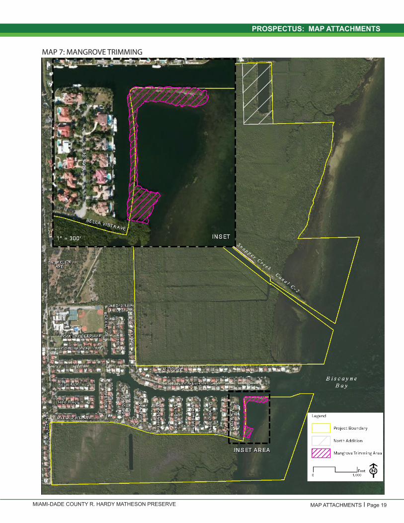
mangrove forest. Areas adjacent to Snapper Creek Canal were graded to ground elevations consistent with the adjacent mangrove forests following the removal of fill material and subsequently planted with mangroves. The County has coordinated with landowners living adjacent to the southern portion of the Preserve to facilitate trimming of mangroves in a small area (Map 6 – Mangrove Trimming Zone) to maintain views of the Bay.
• Marine Submerged Lands - The Preserve includes submerged lands under the waters of Biscayne Bay that are part of the Biscayne Bay Aquatic Preserve (BBAP). These submerged lands consist of soft bottom, hard bottom, and seagrass zones that are tidally influenced with depths sufficient to allow seagrasses to thrive while limiting mangrove expansion. Soft bottom areas exhibit fine layers of silty mud overlaid on limestone rock that provide habitats for various crustaceans and mollusks and other marine organisms. Hard bottom areas consist of limestone with or without a covering of sand on that would provide a substrate for various species of algae to grow. Seagrasses, such as turtle grass, manatee grass, and shoal grass, grow in shallow waters of the bay and provide habitat for fish and other marine wildlife. Historically, the shallow submerged lands of the Bay have been subject to prop scars from boats and other water uses. However, the submerged lands within the Preserve are typically in very good condition outside of the primary channel for the Snapper Creek Canal.
• Developed / Disturbed - Developed/disturbed areas include the entry drive and trail along Snapper Creek Canal. These areas were filled with spoil from the excavation of the Canal. The spoil material was recently removed and much of this area has been replanted with native vegetation. Disturbed areas west and south of Snapper Creek Canal are associated with the Montgomery Botanical Center. These areas include an access point and trails that occurred on the margins of the Preserve prior to acquisition. The remaining disturbed lands occur around the lake in the North Addition and were filled prior to acquisition by the County. Brazilian pepper and Australian pine occur on much of the filled areas by the lake.
The Florida Natural Areas Inventory (FNAI) provided a standard data report that documented element occurrence records on the Preserve for at least 10 plant species and two plant communities (pine rockland and

MIAMI-DADE COUNTY R. HARDY MATHESON PRESERVEPage 4
PROSPECTUS
rockland hammock). Monitoring activities conducted within the Preserve by biologists from Fairchild Tropical Botanic Garden has documented 13 imperiled plant species, including seven species not identified on the FNAI report. Mangrove habitats are home to two of the listed species (the golden leather fern and Christmas berry), while pine rocklands of the Preserve provide habitat for Cartagena prairie-clover, pineland jacquemontia, villose fennel, rockland painted-leaf, five-petaled leaf-flower, and Carter’s small-flowered flax. Redberry stopper, West Indian cherry, and silver palm were noted to occur within the rockland hammocks of the Preserve, while Florida keys nutrush and Florida flatsedge occur in openings in the rockland hammock and/or disturbed areas. The yellowspike orchid, cardinal airplant, and giant airplant are epiphytes that can grow on canopy trees in both the rockland hammock and margins of the mangrove swamp. Current management practices, including exotic species removal and targeted prescribed burns within pine rockland should continue to maintain suitable conditions for these species.
Hurricane Andrew, which struck the east coast of Florida in 1992, significantly impacted the site, damaging the hammock and allowing the widespread establishment of numerous exotic vines and trees. Since that time, the County has undertaken multiple restoration efforts including exotic species removal, which have resulted in greatly improved site conditions.
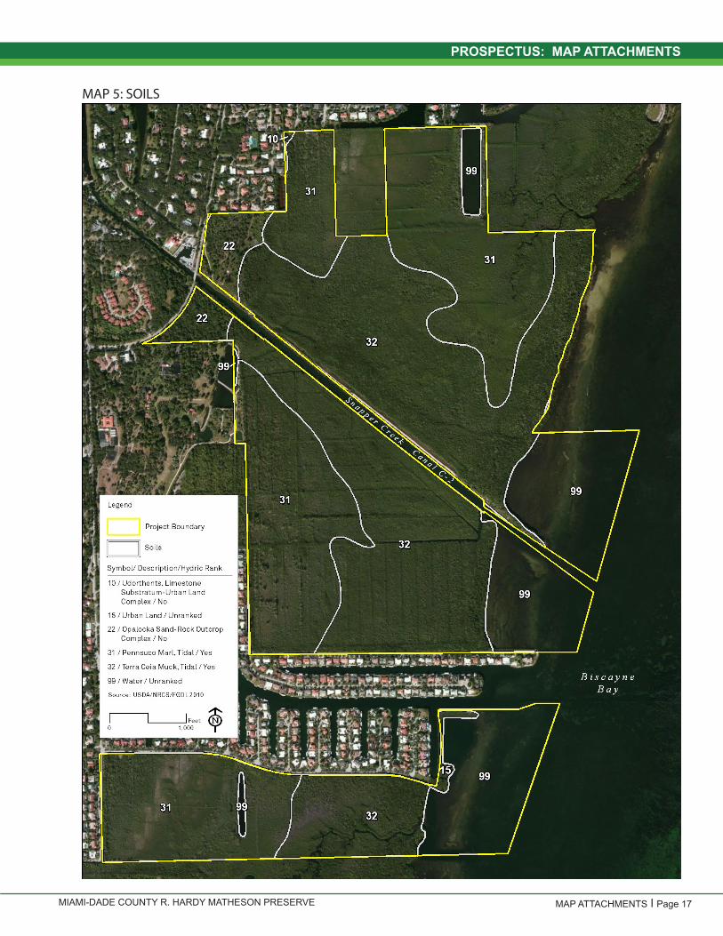
The limestone bluffs overlooking the mangroves are unique geological features on the site. Near the limestone ridge that traverses the rockland hammock, portions of the historical conveyance of Snapper Creek can still be found. Sinkholes and caves, remnants of the old creek, hold pools of crystal clear water fed by seepage that likely occurred within the historical conveyance (estimated in Map 4) and may have represented spring boils or other features of the Creek prior to the channelization activities associated with the Canal. These rock formations are highly unique natural features of the Preserve and are considered an outstanding example of limestone bluffs and caves in Miami-Dade County. The site consists of Terra Ceia muck, Pennsuco marl, Opalocka-rock outcrop complex soil and soil that was removed to create the canal (Map 5).
CULTURAL RESOURCES
R. Hardy Matheson Preserve contains the remains of a prehistoric Indian village dating to 500 BC. This midden, believed to have been occupied by Tequesta Indians, includes a village and quite possibly a cemetery. Unearthed artifacts associated with the village area include tools made from bones, pieces of broken pottery, and ax heads made out of conch shells (Map 7).
With easy access to freshwater springs, the area became an important water stop for passing ships. During the 17th and 18th centuries, settlers built their camps near the original meandering Snapper Creek Canal and the numerous, large freshwater sinkholes. The first settlers planted extensive groves of mango, sapodilla and other tropical fruits. Remnants of these groves may still be found on the site. Through the early 1900’s, Snapper Creek was a very popular picnic site for local residents. A segment of the Ingraham Highway that connected the town of Cutler with Coconut Grove in the 1880s and early 1900s still exists on the Preserve. There is also a partially subterranean structure, commonly known as the “bunker,” located in the northwestern section of the property, which was utilized as a listening station by the Department of Defense during the Cold War.
In 1912-1913, the Snapper Creek Canal was built through the center of the Preserve. The soil or fill removed to create the canal was placed on the north side of the property adjacent to the canal. This fill mound, which contained approximately 500,000 cubic yards, was removed in recent years and the canal bank stabilized. The Canal is one of the first drainage canals constructed in south Florida. The Canal also cuts through the original roadbed of the old Ingraham Highway. Once extending from the Miami River southwest to Cape Sable, the roadbed has since been designated as a historical road by the Miami-Dade County Historic Preservation Board.
CURRENT RECREATION RESOURCES
Currently, there are no developed recreational facilities at the property; with the exception of an informal footpath that spans the length of the maintenance berm along the canal. The path begins at the park entrance and runs along the north side of the canal to Biscayne Bay. The Preserve is not officially open to the public, although public access occurs informally along the trail from Old Cutler Road and from Biscayne Bay. The Preserve is used extensively for fishing and Biscayne Bay sight-seeing.
MIAMI-DADE COUNTY R. HARDY MATHESON PRESERVE Page 5
PROSPECTUS
MANAGEMENT COMPLETED SINCE PREVIOUS PLAN
A management plan for the R. Hardy Matheson Preserve was last adopted 1994. Since that time, the majority of the progress made in management has been in the areas of exotic species removal, habitat restoration and shore stabilization as described below:
• Summer of 2005 – Removed approximately 300,000 cubic yards of excess fill from the site and restored approximately 2.5 acres of mangrove habitat
• Spring of 2006 – Cleared 5.4 acres of Brazilian pepper dominated uplands on the north side of Snapper Creek Canal.
• 2007 – North EEL addition acquired. • 2007-2009 – Planted over 1,000 trees and understory
plants in the area cleared of Brazilian pepper.• 2010 – Cleared 1.5 acres of Brazilian pepper on north
property edge near mangroves. This area still requires continued restoration efforts.
• 2012 – Completed the shoreline stabilization project along the north bank of Snapper Creek Canal.
The site has received annual invasive plant control treatments since 1991 to present. All portions of the Preserve are considered to be in maintenance condition (less than 5% cover invasive plant species) other than the margins of the North Addition.
PROPOSED RECREATIONAL USES
The plan documents the current conceptual general land use plan for the Preserve, which is the long-term, optimal development plan, based on current conditions, location in the regional landscape and the Preserve’s resources (Map 8). A detailed development plan for the Preserve and a site plan for specific facilities will be developed based on this conceptual land use plan, as funding becomes available. The rockland hammocks south of the canal and mangrove areas throughout the Preserve are protected zones within the Preserve, which will be closed to general public use and only available when accompanied by County staff.
Use of the Preserve will be divided into three main areas that will be defined by Snapper Creek, wetlands and
disturbed areas, and existing development adjacent to the property. Over time, signage may be installed to interpret natural and cultural resources on the Preserve.
Area A – This section of the Preserve is north of the Snapper Creek Canal. If it is determined that vehicle parking is a necessity, a parking lot will be constructed in disturbed areas near Old Cutler Road. A nature trail will be developed using the existing maintenance trails and firebreaks. The existing trail on the maintenance berm adjacent to the canal will be maintained as a bicycle/pedestrian trail through the mangrove out to Biscayne Bay. Additional trails may be considered as conditions warrant to provide limited access to the pine rockland area with connections back to the main trail. The bunker will be secured to limit public access. Educational signage about the natural and cultural resources at the Preserve will be located at various intervals along the trail. The trails at R. Hardy Matheson will support pedestrian and bicycle use. Picnic facilities will be located near the entrance to serve as rest areas for trail users and provide visitors the opportunity to relax and enjoy the natural areas.
A canoe landing area will be located near the park entrance within walking distance from the entry. The launch will improve access to the bay and provide safe landing areas from the water.
Area B – is the section of the Preserve that is south of the Snapper Creek Canal and ends at SW 128th Street. This section will remain undeveloped and closed to the public and be designated as a natural area.
Area C – is the section of the Preserve that is directly north of Chapman Field Park and south of residential development. The channel on this section of the Preserve connects to the east lake of Chapman and extends out into the bay. The water trails will provide paddlers’ access to Biscayne Bay and the opportunity to experience mangrove wetland communities first hand. No other improvements are anticipated in this area of the Preserve.Incompatible uses for the Preserve include camping, timber harvesting other than that required for management of the pine rocklands or rockland hammocks, hunting, horseback riding, recreational OHV use outside of the designated area and mountain biking (except on the approved trail). The potential of the Park to accommodate secondary management purposes was analyzed during the development of this plan. Secondary purposes such as water resource development, water supply projects, stormwater management, linear
MIAMI-DADE COUNTY R. HARDY MATHESON PRESERVEPage 6
PROSPECTUS
facilities, mineral extraction, and sustainable forestry and/or agriculture are not consistent with this plan.
MANAGEMENT GOALS
The management goals and objectives for the Preserve are in alignment with those of its managing agency, MDPROS. The agency’s mission is:
“We create outstanding recreational, natural, and cultural experiences to enrich you and to enhance the quality of life for our community for this and future generations.”
The MDPROS Vision Statement is:
“We will build a model park, recreation and open space system to create a healthy, livable, sustainable community and enhance the quality of life for residents and visitors.”
This 10-year management plan provides a basic statement of policy and future direction for the Preserve and is intended to provide a framework for annual management activities. Work plans that provide additional detail on specific activities identified to address goals and objectives of this plan will be prepared annually or as needed to meet Preserve operation needs and provide flexibility for adaptive techniques to be incorporated into the management activities on the site. The goals, objectives and activities identified in this management plan will provide a basis for the work plans developed to implement management of the Preserve. As work plans are implemented, it may become necessary to adjust priority schedules and cost estimates identified within this plan. The following management goals and measurable objectives and activities, both short-term (within the next 2 years) and long-term (3 to 10+ years), have been established for the Preserve. Timeframes for implementation have also been identified in the Year/Frequency column below.
Goal1:Restore and maintain habitat structure and function to maximize native biotic diversity and preserve natural resource values.
Objective 1.1: To control and /or extirpate populations of invasive plants and exotic nuisance animals.
Objective 1.2: To maintain or restore the viability of rare and endemic species consistent with the preservation and restoration of the habitat.
Table 1: Management Goals
25 | P a g e
3. Cultural resource comprehensive survey - $20,000 1
4. Develop and implement educational signage - $2,000 2
5. Canal berm plantings - $50,000 3
6. Fence maintenance and replacement - $35,000 4
7. Bike trail construction - $315,000 5
8. Fishing pier (per pier) - $7,500 6
9. Cover open on floor of bunker - $TBD 7
10. Canal landing improvements - $TBD 8
Table 3: Schedule of Land Management Activities 9
How to Use: goals and objectives are identified above each corresponding table of activities. Priority activities are highlighted in green. Short-10
term is defined as less than two (2) years. Long-term is two (2) or more years. 11
Goal 1: Restore and maintain habitat structure and function to maximize native biotic diversity and preserve natural resource values. 12
Objective 1.1: To control and /or extirpate populations of invasive plants and exotic nuisance animals. 13 14
Activity Short-term
Long-term Priority Year/
Frequency Responsible Entity(ies)
1. Continue to survey pest plant infestations on the Preserve. Yes Yes Yes On-going Miami-Dade County
2. Continue to control invasive pest plants and exotic animals in natural areas. Yes Yes Yes On-going Miami-Dade County
3. Ensure that control measures are not deleterious to native species. Yes Yes Yes On-going Miami-Dade County
4. Coordinate with the Montgomery Botanical Gardens to limit exotic species invasion into the Preserve. Yes Yes Yes On-going Miami-Dade County
15 Objective 1.2: To restore natural area structure and function, native biotic diversity, and natural resource values. 16 17
Activity Short-term
Long-term Priority Year/
Frequency Responsible Entity(ies)
1. Implement the Miami-Dade County Natural Areas Management Plan for habitats on the Preserve. Yes <2 yrs. Miami-Dade County
2. Create a restoration plan for the mangrove, salt marsh, tropical hardwood hammocks, and pine rockland habitats. Yes Yes Yes On-going Miami-Dade County
18 Objective 1.3: To maintain or restore the viability of rare and endemic species consistent with the preservation and restoration of the habitat. 19 20
Activity Short-term
Long-term Priority Year/
Frequency Responsible Entity(ies)
1. Continue the long-term monitoring program for plants and animals of special concern. Yes Yes Yes On-going Miami-Dade
County; Contractor
2. Evaluate information gained through monitoring to modify and improve successful management actions. Yes Yes On-going Miami-Dade County
3. Continue to track and monitor rare plant locations and implement land management activities in a manner that protects rare plants.
Yes Yes Yes On-going Miami-Dade County
4. Reintroduce populations of extirpated species and augment existing populations of rare species where appropriate. Yes <10 yrs. Miami-Dade
County; Fairchild
5. For federally listed species, use USFWS Recovery Plans as guides. Yes <10 yrs Miami-Dade County
21 22 23 24 25 26 27 28 29 30 31 32 33 34 35

MIAMI-DADE COUNTY R. HARDY MATHESON PRESERVE Page 7
PROSPECTUS
Objective 1.3: To maintain or restore the viability of rare and endemic species consistent with the preservation and restoration of the habitat.
Objective 1.4: Institute a fire management program under the direction of the Florida Forest Service in-cluding prescribed burns to restore and maintain fire dependent communities and their historic ecotones.
25 | P a g e
3. Cultural resource comprehensive survey - $20,000 1
4. Develop and implement educational signage - $2,000 2
5. Canal berm plantings - $50,000 3
6. Fence maintenance and replacement - $35,000 4
7. Bike trail construction - $315,000 5
8. Fishing pier (per pier) - $7,500 6
9. Cover open on floor of bunker - $TBD 7
10. Canal landing improvements - $TBD 8
Table 3: Schedule of Land Management Activities 9
How to Use: goals and objectives are identified above each corresponding table of activities. Priority activities are highlighted in green. Short-10
term is defined as less than two (2) years. Long-term is two (2) or more years. 11
Goal 1: Restore and maintain habitat structure and function to maximize native biotic diversity and preserve natural resource values. 12
Objective 1.1: To control and /or extirpate populations of invasive plants and exotic nuisance animals. 13 14
Activity Short-term
Long-term Priority Year/
Frequency Responsible Entity(ies)
1. Continue to survey pest plant infestations on the Preserve. Yes Yes Yes On-going Miami-Dade County
2. Continue to control invasive pest plants and exotic animals in natural areas. Yes Yes Yes On-going Miami-Dade County
3. Ensure that control measures are not deleterious to native species. Yes Yes Yes On-going Miami-Dade County
4. Coordinate with the Montgomery Botanical Gardens to limit exotic species invasion into the Preserve. Yes Yes Yes On-going Miami-Dade County
15 Objective 1.2: To restore natural area structure and function, native biotic diversity, and natural resource values. 16 17
Activity Short-term
Long-term Priority Year/
Frequency Responsible Entity(ies)
1. Implement the Miami-Dade County Natural Areas Management Plan for habitats on the Preserve. Yes <2 yrs. Miami-Dade County
2. Create a restoration plan for the mangrove, salt marsh, tropical hardwood hammocks, and pine rockland habitats. Yes Yes Yes On-going Miami-Dade County
18 Objective 1.3: To maintain or restore the viability of rare and endemic species consistent with the preservation and restoration of the habitat. 19 20
Activity Short-term
Long-term Priority Year/
Frequency Responsible Entity(ies)
1. Continue the long-term monitoring program for plants and animals of special concern. Yes Yes Yes On-going Miami-Dade
County; Contractor
2. Evaluate information gained through monitoring to modify and improve successful management actions. Yes Yes On-going Miami-Dade County
3. Continue to track and monitor rare plant locations and implement land management activities in a manner that protects rare plants.
Yes Yes Yes On-going Miami-Dade County
4. Reintroduce populations of extirpated species and augment existing populations of rare species where appropriate. Yes <10 yrs. Miami-Dade
County; Fairchild
5. For federally listed species, use USFWS Recovery Plans as guides. Yes <10 yrs Miami-Dade County
21 22 23 24 25 26 27 28 29 30 31 32 33 34 35
26 | P a g e
Objective 1.4: Institute a fire management program under the direction of the Florida Forest Service including prescribed burns to restore and 1 maintain fire dependent communities and their historic ecotones. 2 3
Activity Short-term
Long-term Priority Year/
Frequency Responsible Entity(ies)
1. Develop and initiate a prescribed burn plan per Miami-Dade County Natural Areas Management Plan. Yes <2 yrs
Miami-Dade County, Florida Forest
Service
2. Coordinate with the Florida Forest Service and Miami-Dade Fire Rescue to ensure that wildfire response is sensitive to the perpetuation of pine rockland, rockland hammock, mangrove, and salt marsh habitats.
Yes Yes Yes On-going
Miami-Dade County; Florida Forest
Service; Miami-Dade Fire Rescue
3. Continue dialogue with the local community to provide informational and educational materials on and notices of upcoming prescribed burns.
Yes Yes Prior to burns Miami-Dade County
4 Goal 2: Manage the site’s cultural resources in a manner compatible with historic preservation standards and regulations. 5 6 Objective 2.1: To protect and preserve cultural resources on R. Hardy Matheson Preserve. 7 8
Activity Short-term
Long-term Priority Year/
Frequency Responsible Entity(ies)
1. Conduct a systematic archaeological survey of the Preserve to identify and describe prehistoric and historic sites and features and prepare a historic and archaeological report that describes periods of significant human activity, historic resources and structures, and recommendations for interpretation and preservation.
Yes <2 yrs. Miami-Dade County
2. Continue to monitor identified sites and locate areas of probable archaeological sensitivity. Yes Yes Yes On-going Miami-Dade County
3. Continue monitoring ground disturbing activities by notifying the County’s Archaeologist and obtaining a Certificate to Dig from the Regulatory and Economic Resources Department, Office of Historic Preservation.
Yes Yes Yes On-going Miami-Dade County
4. Close the listening station bunker to public access prior to the completion of the bike trail. Yes <2 yrs Miami-Dade County
9 11 Goal 3: Provide authorized public access and increase public awareness while protecting natural areas and cultural resources from adverse 12 human impacts. 13 14 Objective 3.1: Provide compatible public access to Biscayne Bay. 15 16
Activity Short-term
Long-term Priority Year/
Frequency Responsible Entity(ies)
1. Provide pedestrian access at appropriate locations. Yes Yes <1 yr. Miami-Dade County
2. Provide canoe and kayak opportunities. Yes Yes On-going Miami-Dade County
3. Provide a blueway linkage to other coastal public sites such as the Deering Estate at Cutler, Chapman Field Park and Matheson Hammock Park.
Yes On-going Miami-Dade County
4. Continue to allow permitted mangrove pruning that will provide adequate visual access to the residents of Mar Street and San Pedro Road.
Yes Yes 5 to 10+ yrs. Miami-Dade County
5. Provide fishing platform(s) along the north berm of Snapper Creek Canal subject to regulatory approval and funding availability.
Yes 5 to 10+ yrs. Miami-Dade County; District
17 18

MIAMI-DADE COUNTY R. HARDY MATHESON PRESERVEPage 8
PROSPECTUS
Objective 3.1: Provide compatible public access to Biscayne Bay.
Goal3:Provide authorized public access and increase public awareness while protecting natural areas and cultural resources from adverse human impacts.
Goal2: Manage the site’s cultural resources in a manner compatible with historic preservation standards and regu-lations.
Objective 2.1: To protect and preserve cultural resources on R. Hardy Matheson Preserve.
26 | P a g e
Objective 1.4: Institute a fire management program under the direction of the Florida Forest Service including prescribed burns to restore and 1 maintain fire dependent communities and their historic ecotones. 2 3
Activity Short-term
Long-term Priority Year/
Frequency Responsible Entity(ies)
1. Develop and initiate a prescribed burn plan per Miami-Dade County Natural Areas Management Plan. Yes <2 yrs
Miami-Dade County, Florida Forest
Service
2. Coordinate with the Florida Forest Service and Miami-Dade Fire Rescue to ensure that wildfire response is sensitive to the perpetuation of pine rockland, rockland hammock, mangrove, and salt marsh habitats.
Yes Yes Yes On-going
Miami-Dade County; Florida Forest
Service; Miami-Dade Fire Rescue
3. Continue dialogue with the local community to provide informational and educational materials on and notices of upcoming prescribed burns.
Yes Yes Prior to burns Miami-Dade County
4 Goal 2: Manage the site’s cultural resources in a manner compatible with historic preservation standards and regulations. 5 6 Objective 2.1: To protect and preserve cultural resources on R. Hardy Matheson Preserve. 7 8
Activity Short-term
Long-term Priority Year/
Frequency Responsible Entity(ies)
1. Conduct a systematic archaeological survey of the Preserve to identify and describe prehistoric and historic sites and features and prepare a historic and archaeological report that describes periods of significant human activity, historic resources and structures, and recommendations for interpretation and preservation.
Yes <2 yrs. Miami-Dade County
2. Continue to monitor identified sites and locate areas of probable archaeological sensitivity. Yes Yes Yes On-going Miami-Dade County
3. Continue monitoring ground disturbing activities by notifying the County’s Archaeologist and obtaining a Certificate to Dig from the Regulatory and Economic Resources Department, Office of Historic Preservation.
Yes Yes Yes On-going Miami-Dade County
4. Close the listening station bunker to public access prior to the completion of the bike trail. Yes <2 yrs Miami-Dade County
9 11 Goal 3: Provide authorized public access and increase public awareness while protecting natural areas and cultural resources from adverse 12 human impacts. 13 14 Objective 3.1: Provide compatible public access to Biscayne Bay. 15 16
Activity Short-term
Long-term Priority Year/
Frequency Responsible Entity(ies)
1. Provide pedestrian access at appropriate locations. Yes Yes <1 yr. Miami-Dade County
2. Provide canoe and kayak opportunities. Yes Yes On-going Miami-Dade County
3. Provide a blueway linkage to other coastal public sites such as the Deering Estate at Cutler, Chapman Field Park and Matheson Hammock Park.
Yes On-going Miami-Dade County
4. Continue to allow permitted mangrove pruning that will provide adequate visual access to the residents of Mar Street and San Pedro Road.
Yes Yes 5 to 10+ yrs. Miami-Dade County
5. Provide fishing platform(s) along the north berm of Snapper Creek Canal subject to regulatory approval and funding availability.
Yes 5 to 10+ yrs. Miami-Dade County; District
17 18
MIAMI-DADE COUNTY R. HARDY MATHESON PRESERVE Page 9
PROSPECTUS
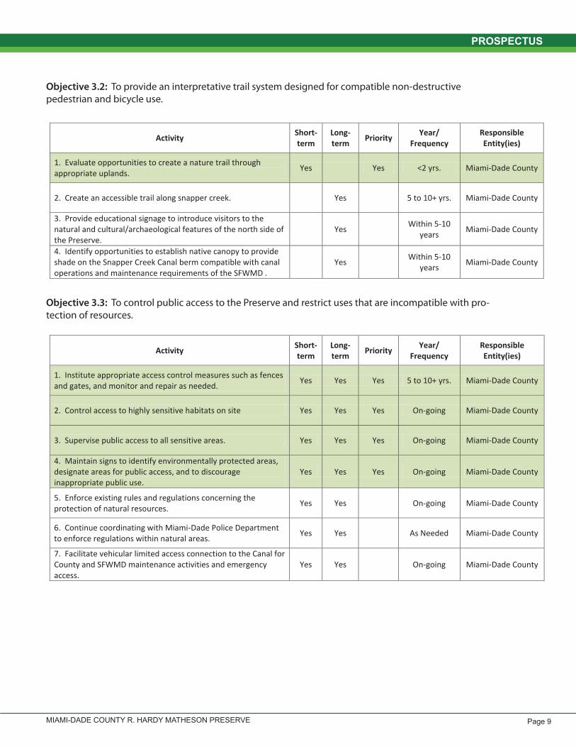
Objective 3.2: To provide an interpretative trail system designed for compatible non-destructive pedestrian and bicycle use.
Objective 3.3: To control public access to the Preserve and restrict uses that are incompatible with pro-tection of resources.
27 | P a g e
Objective 3.2: To provide an interpretative trail system designed for compatible non-destructive pedestrian and bicycle use. 1 2
Activity Short-term
Long-term Priority Year/
Frequency Responsible Entity(ies)
1. Evaluate opportunities to create a nature trail through appropriate uplands. Yes Yes <2 yrs. Miami-Dade County
2. Create an accessible trail along snapper creek. Yes 5 to 10+ yrs. Miami-Dade County
3. Provide educational signage to introduce visitors to the natural and cultural/archaeological features of the north side of the Preserve.
Yes Within 5-10 years Miami-Dade County
4. Identify opportunities to establish native canopy to provide shade on the Snapper Creek Canal berm compatible with canal operations and maintenance requirements of the SFWMD .
Yes Within 5-10 years Miami-Dade County
3 Objective 3.3: To control public access to the Preserve and restrict uses that are incompatible with protection of resources. 4 5
Activity Short-term
Long-term Priority Year/
Frequency Responsible Entity(ies)
1. Institute appropriate access control measures such as fences and gates, and monitor and repair as needed. Yes Yes Yes 5 to 10+ yrs. Miami-Dade County
2. Control access to highly sensitive habitats on site Yes Yes Yes On-going Miami-Dade County
3. Supervise public access to all sensitive areas. Yes Yes Yes On-going Miami-Dade County
4. Maintain signs to identify environmentally protected areas, designate areas for public access, and to discourage inappropriate public use.
Yes Yes Yes On-going Miami-Dade County
5. Enforce existing rules and regulations concerning the protection of natural resources. Yes Yes On-going Miami-Dade County
6. Continue coordinating with Miami-Dade Police Department to enforce regulations within natural areas. Yes Yes As Needed Miami-Dade County
7. Facilitate vehicular limited access connection to the Canal for County and SFWMD maintenance activities and emergency access.
Yes Yes On-going Miami-Dade County
6 7

MIAMI-DADE COUNTY R. HARDY MATHESON PRESERVEPage 10
PROSPECTUS
CONDITIONS AFFECTING MANAGEMENT INTENSITY
Exotic Species Management - Exotic species manage-ment has been ongoing within the Preserve for many years. Continued management to address exotic species infestations that arise or treatment of persistent exotic species populations will continue to enhance the natural areas of the site. The rockland hammock restoration area will continue to be targeted for exotic species removal to allow the planted hammock canopy species to establish. Currently, green iguanas present the most significant ex-otic wildlife issues for the Preserve. MDPROS has worked with local Animal Control, the Humane Society, and in-dependent agencies to develop and implement removal programs where appropriate. Exotic species removal will occur in all natural areas of the site as necessary to meet the maintenance level target.
Hydrological Management - The goal of hydrological management is to protect water dynamics within the Preserve, including water quality, quantity, and inunda-tion periods. The construction of the Snapper Creek Ca-nal in 1912 – 1913 irreparably altered the freshwater flow dynamics of the site. This canal lowered overall ground-water levels thereby decreasing or preventing flow from freshwater spring boils and the remaining portions of the historical Snapper Creek channel. The spoil from the construction was placed on the north side of the canal, which affected circulation of both freshwater and tidal flow into the adjacent mangroves. The spoil from the ca-nal construction has mostly been removed except for an all-season trail along the maintenance berm. Additional hydrological connections may be evaluated over time as funding is available and need is identified for additional connections.
Imperiled Species Management - MDPROS strives to maintain healthy populations of imperiled plant and ani-mal species by implementing effective management of natural communities. Imperiled species management is done as part of a multi-species management approach that includes exotic species control, mechanical man-agement simulating fire, and prescribed fire. The county continues to implement ongoing monitoring of rare plant species within the pine rockland and rockland hammock. Mapping and monitoring of listed species populations will be conducted where possible and appropriate. Inter-pretive trails will avoid areas known to encompass listed species to limit potential impacts.
Fire Management - Fire benefits the pine rockland plant community by recycling nutrients in the form of ash, re-
ducing competition from hard woods, and aiding seed germination by exposing the soil to sunlight. The primary management tool for implementing fires within the Pre-serve will be prescribed burns consistent with the Miami-Dade County Natural Areas Management Plan. Prescribed fire operations in urban areas are very time and resource intensive due to surrounding land use constraints. A pre-scribed burning schedule will be developed in coopera-tion with the Florida Forest Service. Due to the proximity of the project site to residential neighborhoods, careful consideration will be given to the size of burn units and weather conditions at burn time.
Cultural and Historical Resource Management - Archae-ological monitoring will occur during site development and restoration activities to protect existing and possible prehistoric and historic sites and features within the Pre-serve. Artifacts identified during past or future cultural resources surveys will be protected against vandals, col-lectors and site erosion. This includes maintenance of a soil cover over the middens within the former spoil de-position area on the north side of the Canal. The Depart-ment of State, Division of Historical Resources (DHR) will review all archaeological surveys and oversee any activi-ties affecting historic resources. The collection of artifacts or the disturbance of archaeological and historic sites lo-cated on the property will be prohibited unless prior au-thorization is obtained from the DHR.
MANAGEMENT COSTS
Preliminary cost estimates for activities requiring more than staff time. The ability to complete any identified ob-jectives and actions outlined in the management plan is contingent on the availability of funding and other re-sources being available for the purposes specified. Spe-cific costs will be determined at the time of design and construction of these improvements.
1. Annually monitor and treat the pine rockland/ rock-land hammock habitats to remove exotic species - $10,000 / yr
2. Annual rare plant species monitoring - $1,500 / yr3. Cultural resource comprehensive survey - $20,0004. Develop and implement educational signage -
$2,0005. Canal berm plantings - $50,0006. Fence maintenance and replacements - $35,0007. Bike trail construction - $315,0008. Fishing dock (per dock) -$7,5009. Cover open floor of bunker - $TBD
MIAMI-DADE COUNTY R. HARDY MATHESON PRESERVE Page 11
PROSPECTUS
PAGE INTENTIONALLY LEFT BLANK

MIAMI-DADE COUNTY R. HARDY MATHESON PRESERVE
PROSPECTUS:MAP ATTACHMENTS

MIAMI-DADE COUNTY R. HARDY MATHESON PRESERVE
MAP 1: NEARBY PUBLIC LAND

MIAMI-DADE COUNTY R. HARDY MATHESON PRESERVEPage 14 l MAP ATTACHMENTS
PROSPECTUS: MAP ATTACHMENTS
MAP 2: AERIAL PHOTOGRAPH

MIAMI-DADE COUNTY R. HARDY MATHESON PRESERVE MAP ATTACHMENTS l Page 15
PROSPECTUS: MAP ATTACHMENTS
MAP 3: PLANT COMMUNITIES

MIAMI-DADE COUNTY R. HARDY MATHESON PRESERVEPage 16 l MAP ATTACHMENTS
PROSPECTUS: MAP ATTACHMENTS
MAP 4: HISTORIC SNAPPER CREEK
MIAMI-DADE COUNTY R. HARDY MATHESON PRESERVE MAP ATTACHMENTS l Page 17
PROSPECTUS: MAP ATTACHMENTS
MAP 5: SOILS

MIAMI-DADE COUNTY R. HARDY MATHESON PRESERVEPage 18 l MAP ATTACHMENTS
PROSPECTUS: MAP ATTACHMENTS
MAP 6: CULTURAL RESOURCES
MIAMI-DADE COUNTY R. HARDY MATHESON PRESERVE MAP ATTACHMENTS l Page 19
PROSPECTUS: MAP ATTACHMENTS
MAP 7: MANGROVE TRIMMING

MIAMI-DADE COUNTY R. HARDY MATHESON PRESERVEPage 20 l MAP ATTACHMENTS
PROSPECTUS: MAP ATTACHMENTS
MAP 8: CONCEPTUAL GENERAL PLAN

MIAMI-DADE COUNTY R. HARDY MATHESON PRESERVE MAP ATTACHMENTS l Page 21
PROSPECTUS: MAP ATTACHMENTS
MAP 9: POTENTIAL FUTURE ACQUISITIONS

PARKS,RECREATIONandOPENSPACESDEPARTMENT
R. HARDY MATHESON PRESERVE - PROSPECTUS


