Microblock rotations and fault coupling in SE Asia triple junction (Sulawesi, Indonesia) from GPS and earthquake slip vector data Anne Socquet, 1,2 Wim Simons, 1 Christophe Vigny, 3 Robert McCaffrey, 4 Cecep Subarya, 5 Dina Sarsito, 6 Boudewijn Ambrosius, 1 and Wim Spakman 7 Received 19 July 2005; revised 31 March 2006; accepted 23 May 2006; published 31 August 2006. [1] The island of Sulawesi, eastern Indonesia, is located within the triple junction of the Australian, Philippine, and Sunda plates and accommodates the convergence of continental fragments with the Sunda margin. We quantify the kinematics of Sulawesi by modeling GPS velocities and earthquake slip vectors as a combination of rigid block rotations and elastic deformation around faults. We find that the deformation can be reasonably described by a small number of rapidly rotating crustal blocks. Relative to the Sunda Plate, the southwestern part of Sulawesi (Makassar Block) rotates anticlockwise at 1.4°/Myr. The northeastern part of Sulawesi, the Bangai-Sula domain, comprises three blocks: the central North Sula Block moves toward the NNW and rotates clockwise at 2.5°/Myr, the northeastern Manado Block rotates clockwise at 3°/Myr about a nearby axis, and East Sulawesi is pinched between the North Sula and Makassar blocks. Along the boundary between the Makassar Block and the Sunda Plate, GPS measurements suggest that the trench accommodates 15 mm/yr of slip within the Makassar Strait with current elastic strain accumulation. The tectonic boundary between North Sula and Manado blocks is the Gorontalo Fault, moving right laterally at about 11 mm/yr and accumulating elastic strain. The 42 mm/yr relative motion between North Sula and Makassar blocks is accommodated on the Palu-Koro left-lateral strike-slip fault zone. The data also indicate a pull-apart structure in Palu area, where the fault shows a transtensive motion and may have a complex geometry involving several active strands. Sulawesi provides a primary example of how collision can be accommodated by crustal block rotation instead of mountain building. Citation: Socquet, A., W. Simons, C. Vigny, R. McCaffrey, C. Subarya, D. Sarsito, B. Ambrosius, and W. Spakman (2006), Microblock rotations and fault coupling in SE Asia triple junction (Sulawesi, Indonesia) from GPS and earthquake slip vector data, J. Geophys. Res., 111, B08409, doi:10.1029/2005JB003963. 1. Introduction [2] Relative motions between major, fast moving plates can sometimes be accommodated within a complex deform- ing zone that involves microblocks rotating rapidly about nearby poles (e.g., Cascadia, Marianas, Vanuatu, Papua New Guinea, New Zealand, Tonga) [McCaffrey et al., 2000; Kato et al., 2003; Calmant et al., 2003; Wallace et al., 2004, 2005], resulting in complex plate interactions. The boundaries between these rotating microplates are often the sites of major collisional orogenies, subduction zones, rift systems, and rapidly slipping transform faults. Accurate assessment of the kinematics of these convergent plate boundary microblocks, by using Global Positioning System (GPS) techniques for example, may help us help us resolve long-standing questions about the forces driving microplate rotation. [3] Because the triple junction between the Philippine Sea, Australian, and Sunda plates in Southeast Asia is highly seismically active and is characterized by rapid rotations of small blocks revealed by both geological and kinematic studies [Fitch and Hamilton, 1974; Hamilton, 1972; Kreemer et al., 2000; Silver et al., 1983a; Silver and Moore, 1978; Simons et al., 2000; Stevens et al., 1999; Vigny et al., 2002; Walpersdorf et al., 1998a, 1998b] (Figure 1), it constitutes a type example of how a collision can be accommodated by block rotation instead of mountain building. However, to more fully understand this process, a more precise description of these microblock’s motions and a better understanding of the main active structures of the JOURNAL OF GEOPHYSICAL RESEARCH, VOL. 111, B08409, doi:10.1029/2005JB003963, 2006 Click Here for Full Articl e 1 Department of Earth Observation and Space Systems, Delft University of Technology, Delft, Netherlands. 2 Department of Earth and Space Sciences, University of California, Los Angeles, California, USA. 3 Laboratoire de Ge ´ologie de l’Ecole Normale Supe ´rieure, UMR CNRS 8538, Paris, France. 4 Department of Earth and Environmental Sciences, Rensselaer Poly- technic Institute, Troy, New York, USA. 5 National Coordination Agency for Surveys and Mapping, Cibinong, Indonesia. 6 Geodesy Research Group, Faculty of Civil and Environmental Engineering, Institute of Technology Bandung, Bandung, Indonesia. 7 Faculty of Earth Sciences, Utrecht University, Utrecht, Netherlands. Copyright 2006 by the American Geophysical Union. 0148-0227/06/2005JB003963$09.00 B08409 1 of 15
Transcript
Microblock rotations and fault coupling in SE Asia triple junction
(Sulawesi, Indonesia) from GPS and earthquake slip vector data
Anne Socquet,1,2 Wim Simons,1 Christophe Vigny,3 Robert McCaffrey,4 Cecep Subarya,5
Dina Sarsito,6 Boudewijn Ambrosius,1 and Wim Spakman7
Received 19 July 2005; revised 31 March 2006; accepted 23 May 2006; published 31 August 2006.
[1] The island of Sulawesi, eastern Indonesia, is located within the triple junction of theAustralian, Philippine, and Sunda plates and accommodates the convergence ofcontinental fragments with the Sunda margin. We quantify the kinematics of Sulawesi bymodeling GPS velocities and earthquake slip vectors as a combination of rigid blockrotations and elastic deformation around faults. We find that the deformation can bereasonably described by a small number of rapidly rotating crustal blocks. Relative to theSunda Plate, the southwestern part of Sulawesi (Makassar Block) rotates anticlockwise at�1.4�/Myr. The northeastern part of Sulawesi, the Bangai-Sula domain, comprises threeblocks: the central North Sula Block moves toward the NNW and rotates clockwise at�2.5�/Myr, the northeastern Manado Block rotates clockwise at �3�/Myr about a nearbyaxis, and East Sulawesi is pinched between the North Sula and Makassar blocks. Alongthe boundary between the Makassar Block and the Sunda Plate, GPS measurementssuggest that the trench accommodates �15 mm/yr of slip within the Makassar Strait withcurrent elastic strain accumulation. The tectonic boundary between North Sula andManado blocks is the Gorontalo Fault, moving right laterally at about 11 mm/yr andaccumulating elastic strain. The 42 mm/yr relative motion between North Sula andMakassar blocks is accommodated on the Palu-Koro left-lateral strike-slip fault zone. Thedata also indicate a pull-apart structure in Palu area, where the fault shows a transtensivemotion and may have a complex geometry involving several active strands. Sulawesiprovides a primary example of how collision can be accommodated by crustal blockrotation instead of mountain building.
Citation: Socquet, A., W. Simons, C. Vigny, R. McCaffrey, C. Subarya, D. Sarsito, B. Ambrosius, and W. Spakman (2006),
Microblock rotations and fault coupling in SE Asia triple junction (Sulawesi, Indonesia) from GPS and earthquake slip vector data,
J. Geophys. Res., 111, B08409, doi:10.1029/2005JB003963.
1. Introduction
[2] Relative motions between major, fast moving platescan sometimes be accommodated within a complex deform-ing zone that involves microblocks rotating rapidly aboutnearby poles (e.g., Cascadia, Marianas, Vanuatu, PapuaNew Guinea, New Zealand, Tonga) [McCaffrey et al.,2000; Kato et al., 2003; Calmant et al., 2003; Wallace et
al., 2004, 2005], resulting in complex plate interactions.The boundaries between these rotating microplates are oftenthe sites of major collisional orogenies, subduction zones,rift systems, and rapidly slipping transform faults. Accurateassessment of the kinematics of these convergent plateboundary microblocks, by using Global Positioning System(GPS) techniques for example, may help us help us resolvelong-standing questions about the forces driving microplaterotation.[3] Because the triple junction between the Philippine
Sea, Australian, and Sunda plates in Southeast Asia ishighly seismically active and is characterized by rapidrotations of small blocks revealed by both geological andkinematic studies [Fitch and Hamilton, 1974; Hamilton,1972; Kreemer et al., 2000; Silver et al., 1983a; Silver andMoore, 1978; Simons et al., 2000; Stevens et al., 1999;Vigny et al., 2002; Walpersdorf et al., 1998a, 1998b](Figure 1), it constitutes a type example of how a collisioncan be accommodated by block rotation instead of mountainbuilding. However, to more fully understand this process, amore precise description of these microblock’s motions anda better understanding of the main active structures of the
JOURNAL OF GEOPHYSICAL RESEARCH, VOL. 111, B08409, doi:10.1029/2005JB003963, 2006ClickHere
for
FullArticle
1Department of Earth Observation and Space Systems, Delft Universityof Technology, Delft, Netherlands.
2Department of Earth and Space Sciences, University of California, LosAngeles, California, USA.
3Laboratoire de Geologie de l’Ecole Normale Superieure, UMR CNRS8538, Paris, France.
4Department of Earth and Environmental Sciences, Rensselaer Poly-technic Institute, Troy, New York, USA.
5National Coordination Agency for Surveys and Mapping, Cibinong,Indonesia.
6Geodesy Research Group, Faculty of Civil and EnvironmentalEngineering, Institute of Technology Bandung, Bandung, Indonesia.
7Faculty of Earth Sciences, Utrecht University, Utrecht, Netherlands.
Copyright 2006 by the American Geophysical Union.0148-0227/06/2005JB003963$09.00
area are necessary. The purpose of this paper study is todefine the deformation of the Sulawesi area utilizing geo-detic and seismological data. Using a decade of GPSmeasurements, we estimate the kinematics and likelyboundaries of the micro blocks. We also examine the activefaults of Sulawesi (e.g., Palu-Koro and Gorontalo strike-slipfaults) in detail to quantify their interseismic behavior andassess their contributions to seismic hazards. Toward theseends, we model our GPS velocities and earthquake slipvector azimuths with a combination of rigid block rotations[Morgan, 1968; Peltzer and Saucier, 1996] and elasticdeformation due to locking on the faults separating theblocks [Okada, 1985, 1992; Savage, 1983; Savage andBurford, 1973]. This simultaneous inversion results in Eulervectors describing rigid block rotation in addition to degreeof coupling on the faults.
2. Geodynamic Setting
2.1. Present-Day Kinematics
[4] According to the NUVEL-1A plate motion model, thetriple junction of Southeast Asia is a trench-trench-fault(T-T-F) type between the Eurasian (or Sunda), Australian,and Philippine plates [DeMets et al., 1990, 1994] (Figure 1).The Australian and Philippine plates subduct beneath theEurasia (or Sunda) Plate at rates of 75 and 90 mm/yr,respectively. The E-W trending Australia–Philippine Sea/Pacific boundary zone that extends from eastern Indonesiathrough NewGuinea accommodates the relative plate motionby transpressive faulting and tectonic block rotation[Tregoning et al., 1998, 1999, 2000; Stevens et al.,2002; Wallace et al., 2004]. GPS measurement in Indo-nesia have helped considerably to refine the plate kine-matics of Southeast Asia [Puntodewo et al., 1994;Tregoning et al., 1994; Genrich et al., 1996, 2000;
Prawirodirdjo et al., 1997, 2000; Michel et al., 2001;Bock et al., 2003]. In particular, GPS velocities revealedthat the Eurasian Plate does not include Southeast Asia,but instead the separate Sunda Plate moves at about 10mm/yreastward relative to Eurasia [Chamot-Rooke and Le Pichon,1999;Michel et al., 2001; Simons et al., 1999]. Studies basedon denser GPS arrays in Sulawesi reveal even finer detail onblock-like motions, for example, rapid clockwise rotation ofthe northern part of the Sulawesi Island, named the SulaBlock, with respect to the Sunda Block [Walpersdorf et al.,1998a, 1998b; Stevens et al., 1999]. The latest study, based on100+ sites in SEAsia, shows that deformation affects both theEast Borneo and Sulawesi areas, while southern Sulawesi inparticular, also moves independently of the Sunda Plate(W. J. F. Simons et al., A decade of GPS measurementsin SE Asia: (Re)defining Sundaland and its boundaries,unpublished manuscript, 2005, hereinafter referred to asSimons et al., unpublished manuscript, 2005). Thesestudies show that Sulawesi is clearly not a part of theSunda Plate, but instead is itself broken into multiplemicroblocks accommodating complex deformation.
2.2. Regional Active Structures
[5] The active structures of the Sulawesi area showcomplex patterns of faulting [Hall, 2002; Hall and Wilson,2000] (Figure 1). The Sunda Plate is bounded to the southby the Sunda-Banda arc which is associated with thenorthward subduction of the Australian Plate. Subductionof the Australian Plate at the Java Trench evolves intocollision with Australia along the Timor Trough south ofSulawesi [McCaffrey and Abers, 1991]. Highly obliqueconvergence (�110 mm/yr) between the Pacific (or Caro-line after [Weissel and Anderson, 1978]) and the Australianplates is accommodated in western New Guinea whereshortening and left-lateral shear are distributed among
Figure 1. Structural map of the Sunda–Australia–Philippine–Pacific plates junction area. Arrowsdepict the far-field velocities of the plates with respect to Eurasia. Fault traces are adapted from Hamilton[1979].
B08409 SOCQUET ET AL.: DEFORMATION IN EAST INDONESIA FROM GPS
2 of 15
B08409
several tectonic boundaries [McCaffrey and Abers, 1991;Puntodewo et al., 1994; Stevens et al., 2002]. Faults in NewGuinea continue to the west to the Seram Trough and to theSula-Sorong Fault that continues into Sulawesi. In thePhilippines, the oblique convergence between the Sundaand Philippine plates is accommodated by partitioning ofthe slip between the Philippine Trench and the PhilippineFault [Aurelio, 2000; Fitch, 1972]. The Manila-Philippine
trench system (Figure 1) undergoes trench-normal conver-gence [Rangin et al., 1999] while left-lateral strike slip istaken up on the Philippine Fault [Barrier et al., 1991].[6] The central part of the Southeast Asia triple junction
coincides with Sulawesi (Figure 2). The northern part of theisland, is colliding with the Sunda Plate [Rangin, 1989;Silver et al., 1983a, 1983b]. This relative motion is accom-modated by left-lateral strike-slip motion along the Matano/
Figure 2. GPS velocities of Sulawesi and surrounding sites with respect to the Sunda Plate. Greyarrows belong to the Makassar Block, black arrows belong to the northern half of Sulawesi, and whitearrows belong to non-Sulawesi sites (99% confidence ellipses). Numbers near the tips of the vectors givethe rates in mm/yr. The main tectonic structures of the area are shown as well.
B08409 SOCQUET ET AL.: DEFORMATION IN EAST INDONESIA FROM GPS
3 of 15
B08409
Lawanopo Fault (the western continuation of the Sula-Sorong Fault [Hinschberger et al., 2000]) which continuesto the Palu–Koro Fault in the north, which then connects tothe Minahassa Trench where subduction occurs (Figure 2).The Gorontalo strike-slip fault cuts the northern arm ofSulawesi and may connect to the Minahassa Trench. At theeastern termination of the Minahassa Trench, the Sangihedouble subduction zone accommodates convergence be-tween the Philippine Plate and Sulawesi across the MoluccaSea (Figure 2).[7] The main active structure in Sulawesi is the Palu-
Koro Fault and its southeast continuation to the MatanoFault and/or Lawanopo Fault. The Palu-Koro Fault bisectsthe island: the Makassar Block on the southwest and theNorth Sula Block on the northeast. GPS shows that the totalmotion across the fault is around 4 cm/yr. If this slip occurson one single fault locked at depth [Stevens et al., 1999;Walpersdorf et al., 1998c], then it should produce at leastone magnitude 7 earthquake every 100 years [Wells andCoppersmith, 1994]. This history of earthquakes is not seenin trenching in the Palu area [Bellier et al., 2001], whichposes a problem for reconciling neotectonics with thepresent-day geodetic rates.
3. GPS Velocity Field of the Triple Junction Area
3.1. GPS Measurements
[8] The first GPS measurements in Sulawesi took place in1992 [Bock et al., 2003] at which time detailed transectswere also established across the Palu-Koro and Gorontalofaults [Stevens et al., 1999]. Concurrently, in the GEO-DYSSEA project, a network of about 40 geodetic pointscovering an area of 4000 by 4000 km in Southeast Asia wasinstalled and measured between 1994 and 1998 [Michel etal., 2001]. In Sulawesi, the GPS network has been increasedfrom the original eight GEODYSSEA sites in 1994 to morethan 30 by 2003, plus 25 additional transect points acrossthe Palu-Koro and Gorontalo faults. This network has beenremeasured yearly since 1996. Since 1999, six continuousGPS stations have been installed mainly to study thetransient behavior of the Palu-Koro Fault.
3.2. GPS Processing
3.2.1. Regional Processing[9] The Sulawesi GPS data (campaign and continuous
measurements) have been included in regional processingcovering the entire Southeast Asia (Simons et al., unpub-lished manuscript, 2005). The station daily positions werecomputed with GIPSY software [Blewitt et al., 1988],applying the PPP strategy to the ionosphere-free combi-nation of the zero-differenced GPS dual-frequency observ-ables at 5 min intervals, with a cutoff angle of 15�.Tropospheric delays and gradients were estimated at eachinterval. The processing included ocean loading parameters[Scherneck, 1991], variations of the antennae phase centers(National Geodetic Survey (NGS) [Mader, 1998]), precisesatellite orbits and clocks, as well as Earth orientationparameters distributed by the Jet Propulsion Laboratory(JPL). Finally, the individual PPP solutions were mergedinto a daily network solution after which the ambiguitieswere fixed to integer values. These daily network solutionswere combined into weekly or campaign-averaged solu-
tions. The daily coordinate repeatabilities for the Sulawesinetwork have an internal accuracy of about 2 and 5 mmfor the east and north positions and 9 mm for the height.These errors are slightly higher than those of the includedIGS network, and can be explained by the less ideal siteconditions (sky visibility and multipath issues) in Sula-wesi. The 23 IGS stations included in the data set allowedus to project each multiday averaged solution onto theITRF-2000 reference frame [Altamimi et al., 2002], byapplying seven-parameter Helmert transformations to theirpositions. The coordinate residuals between the projectedand the predicted ITRF-2000 positions at each analyzedepoch exhibit stable RMS values of about 2 to 3 mm forthe east and north, and 8 mm for the vertical position. Thesites velocities were estimated by computing a linear fitthrough all the ITRF-2000 mapped coordinate time series,while excluding any epochs that were clearly disturbed byseismic events. The coordinate residuals with respect tothe linear trend at each analyzed epoch have 3-D RMSvalues of 2, 3 and 8 mm for east, north, and up. Thedifferences between the estimated and the ITRF-2000velocities for the IGS stations used for the mapping haveRMS values of 0.6, 0.7 and 2.5 mm/yr, respectively,indicating that the local velocity estimates are consistentlycomputed in a stable reference frame. The uncertainties ofthe horizontal velocity vectors in Sulawesi range from 0.5to 3.0 mm/yr, depending on the number of sessions orcampaigns and on the total time span between first and lastoccupation at each site.3.2.2. Palu Transect Relative Processing[10] The main objective of the Palu transect study is to
estimate the velocity variations across the Palu-Koro Faultwith high relative accuracy. Therefore we follow a differentobservation and processing strategy: each year the WATAstation was taken as a continuously recording reference andthe other transect sites were each occupied for 24 hours ormore. The positions of all the network sites were computedsimultaneously with respect to WATA, following a fiducialnetwork strategy which provides two important advantages.First, since the network is small (diameter of 60 km, noIGS sites included), almost all the ambiguities can be fixed.Second, there is no need to map the network into a globalreference frame. The small network aperture allows forshorter observation periods and prevents loss of relativeaccuracy as a result of mapping errors into a globalreference frame. The velocities with respect to the refer-ence station are estimated as a linear fit through the timeseries of their relative positions. Daily network compar-isons show small, randomly distributed residuals at eachstation and no systematic network rotation is found. TheRMS of the daily coordinate repeatabilities with thistechnique is 2, 2 and 8 mm for each direction between1998 and 2004, with slightly higher values in 1997 whensome transect sites were occupied for only 3 to 4 hours.Long-term uncertainties (epoch residuals relative to a lineartrend) have the same amplitude (a few mm) as the short-term uncertainties (daily repeatabilities). This agreementindicates that uncertainties are correctly estimated and thatstation positions are free of unidentified biases. Hence thePalu transect relative processing, although based on bothfewer and shorter observation periods, delivers (relative)velocity estimates with an uncertainty (1s) ranging from
B08409 SOCQUET ET AL.: DEFORMATION IN EAST INDONESIA FROM GPS
4 of 15
B08409
0.3 to 1.5 mm/yr for the sites that were measured at least3 times.
3.3. Obtaining a Consistent Velocity Field
[11] The Palu transect velocities are processed relative tothe westernmost station of the transect, WATA. In order toget the velocities of the transect in a global reference frame,we simply add the velocity of WATA in ITRF-2000 to allthe points of the transect. In doing this we assume that thetransect is affected only by translation at such a small scale(60 km at most). Indeed, the two independent determina-tions (relative and regional) of the velocity of the transect’seasternmost site (TOBO, also continuously measured) withrespect to that of WATA agree within 0.6 mm/yr. Thevelocities (in the ITRF2000) of this combined solution(regional + relative) are listed in the auxiliary material.1
4. Modeling the Velocity Field
4.1. Description of the Velocities in Sulawesi Area
[12] We specify several tectonic blocks in the Sulawesiregion based on the GPS velocities and the geological andseismological evidence for active faulting. Figure 2 displaysthe velocities relative to the Sunda Plate reference frame[Socquet et al., 2006; Simons et al., unpublished manu-script, 2005], and Figure 3 shows the focal mechanisms inthe same region. The first obvious pattern from the GPSvelocities is the division of the island into two independentdomains. In the south, the Makassar Block (grey arrows)
displays a small but significant motion relative to Sundaappearing to rotate anticlockwise around a pole located nearits southwestern tip. The Makassar Trench (Figure 4)bounds this block to the west and accommodates at leastpart of the Sunda/Makassar convergence. The East SulawesiTrench constitutes the boundary of the Makassar and EastSula blocks with the Banda Sea. The northern half ofSulawesi (black arrows) moves toward the NNWand rotatesclockwise around a pole located near its northeastern tip.The northern half of Sulawesi is divided into three smallerblocks. The eastern part of the northern arm of Sulawesi,here named the Manado Block, has an independent motionfrom the North Sula Block. These two entities are separatedby the Gorontalo Fault, evident in geology. The boundarybetween the Makassar and North Sula blocks is the Palu-Koro Fault. Last, the eastern arm of Sulawesi also showsindependent motion from North Sula, indicated by westtrending GPS vectors at sites LUWU, AMPA, and KAMB.Because of the sparseness of our network in this area, moreexact boundaries of this block (here named East Sulawesi)are difficult to draw. East of Sulawesi, we define the BandaSea as a rigid block on which we have only two GPSvelocities: at SANA and AMBO.
4.2. Data Modeling Approach
[13] The relatively small, rotating blocks are surroundedby active faults where interseismic coupling produceselastic deformation within the blocks. In many instances,a substantial amount of the block’s surface is below sealevel and inaccessible to standard GPS measurements soonly a part of the block has constraints. For example, in thenorthern half of Sulawesi the Tomini Gulf covers the central
Figure 3. Post-1976 instrumental CMT focal mechanismsfrom Harvard catalogue in the Sulawesi area. The size of thesymbol is proportional to the earthquake magnitude. Focalmechanisms in grey, labeled by date (year/month/day) andmagnitude, correspond to the earthquakes cited in the text.
Figure 4. Blocks geometries used for the modeling. Theobserved (black) and the modeled (grey) slip vectors ofmodel 2 are also shown. NSB, North Sula Block; PF, PaluFault; TG, Tomini Gulf fault zone; GF, Gorontalo Fault.
1Auxiliary materials are available at ftp://ftp.agu.org/apend/jb/2005jb003963.
B08409 SOCQUET ET AL.: DEFORMATION IN EAST INDONESIA FROM GPS
5 of 15
B08409
part of the area (Figure 2). Because of the limited sampling,it is difficult to identify observation points that may indicaterigid block rotations only, i.e., no closer than 100km fromany active fault. Consequently, the velocities of most pointsresult from a combination of rigid rotations and elasticloading on faults. Therefore we use an inversion approachthat simultaneously estimates the angular velocities ofelastic blocks on a sphere and creep fractions (e.g., couplingcoefficients) on block-bounding faults. For this purpose weuse the DEFNODE software [McCaffrey, 1995, 2002, 2005]which applies simulated annealing to downhill simplexminimization [e.g., Press et al., 1989] to solve for themodel parameters. We minimize data misfit, defined bythe reduced chi-square statistic: cn
2 = (P
r2/s2)/DOF, wherer is the residual, s is the standard deviation and DOF givesthe degrees of freedom (number of data minus number offree parameters).[14] The coupling fraction (ratio of locked to total slip)
on the fault is defined as a purely kinematic quantity, j. Ifj = 0, the fault is creeping at the full long-term slip rate andif j = 1, the fault interface is fully locked during the inter-seismic period. Since the GPS data we use are sparse, weassume that this coupling fraction is uniform over largepatches of the faults. However, we allowed it to vary alongthe Palu Fault and the Minahassa Trench in some inversionswhere the GPS arrays are denser. The relative motion on thefaults is determined by the Euler vectors describing themotions of the blocks adjacent to the fault. The slip rate de-ficit vector on the fault is the scalar coupling value j mul-tiplied by the relative motion vector between the two blocksat a given fault. The elastic contribution to the velocity fieldfrom the fault slip rate deficit is calculated using a back slipapproach to elastic dislocation modeling [Savage, 1983],using the formulations of Okada [1985] for surface dis-placements due to dislocations in an elastic half-space.
4.3. Results of the Models
[15] In the first model presented here, we use GPS dataonly (applying the 2-sigma uncertainty) to estimate theangular velocities of five blocks (North Sula, Makassar,Manado, Banda Sea, East Sula) and the average couplingratio on seven faults bounding the blocks (Palu Fault,Gorontalo Fault, Minahassa Trench, Makassar Trench, EastSulawesi Trench, Lawanopo Fault, and Tomini Gulf faultzone, Figure 3). Given the high number of sites located nearthe Palu and Gorontalo faults compared to the number ofsites located on the stable blocks away from faults, we down
weigh the former by a factor of 4 to estimate the blocksrotations using the geographically distributed data. Weobtain cn
2 = 8.3 (100 observations, 78 degrees of freedom,Table 1). This model produces very large uncertainties inthe estimates of some block motions and fault couplingcoefficients (on the east Sulawesi Trench, for example,Table 2). Therefore, in a second inversion, in addition tothe GPS data, we use earthquake slip vector azimuthsextracted from Harvard centroid moment tensor (CMT)focal mechanisms (Figures 3 and 4). We apply an uncer-tainty of 10� on the azimuth of the slip vectors except forthose from the Minahassa Trench, where the uncertainty hasbeen fixed at 20� for the western part and 40� for the easternpart because of the abundance of earthquake data in theseareas. In this model, we allow the coupling ratio of the PaluFault and the Minahassa Trench to vary along strike.Although we have in this second model more parametersto estimate, the addition of these slip vector data reduces cn
2
to 6.4 (191 observations, 164 degrees of freedom) andreduces uncertainties on the blocks’ Euler vectors by afactor of 2 to 3. The cn
2 obtained for the best modeldecreases to 3.6 if the outliers (AMBO and WUAS) areexcluded from the model. The misfit to the data remainshowever high, indicating that the formal uncertainties de-rived from the GPS processing are underevaluated and stillpoorly estimated. For the present data set, to obtain arealistic estimate of the error on the GPS velocities, oneshould take 4-sigma of the formal uncertainty given inTable S1 in the auxiliary material (in the inversion, uncer-tainties have already been scaled by 2).[16] Table 3 summarizes the poles of rotation we obtain
for the various blocks and models. It is noticeable that thepoles obtained by the two inversions are similar for theblocks that have several GPS velocities (i.e., North Sula,Manado and Makassar blocks). However, slip vectorsprovide useful constraints for the blocks that have sparseGPS observations (East Sulawesi Block and Banda SeaBlock). Table 2 gives the fault geometries at depth, theestimated coupling ratios and slip rates for the two models.Once again, the estimation of the coupling ratio is improvedby the addition of slip vector constraints for the faults thatare not surrounded by GPS stations (Makassar Trench, EastSulawesi Trench, Lawanopo Fault and Tomini Gulf faultzone). However, the amount of coupling on the Palu Fault,the Gorontalo Fault and the Minahassa Trench is betterdetermined in the model with GPS data only, since the localnetworks around these faults are very dense. Also note that
Table 1. Probablilities Derived From F Tests of Block Independence for Various Tectonic Blocks/Faults Modelsa
Model Number of Blocks Number of Data Number of Parameters DOF cn2
Is Model 2 Better?
Probability, % Answer
1, GPS only 6 100 22 78 8.3 91 yes2, GPS plus SV, best model 6 191 27 164 6.43, MANA = NSUL 5 191 23 168 6.6 56 maybe4, NSUL = ESUL 5 179 23 156 7.2 76 maybe5, ESUL = MANA 5 191 24 167 8.2 94 yes6, ESUL = NSUL = MANA 4 179 19 160 7.4 80 yes7, MAKA = ESUL 5 187 24 163 12.3 99 yes8, BSEA = MAKA 5 185 24 161 10.8 99 yes
aExcept for model 1 where only GPS data were used, all GPS and slip vector (SV) data were used for these models. In model 1, the coupling ratio alongall the faults was uniform. In the other models, the coupling ratio is allowed to vary along the Palu Fault and the Minahassa–North Sulawesi Trench and isuniform along the other faults. Models 3 to 8 are derived from model 2, with fewer blocks considered. For each model, the blocks listed comprise a singlerotating unit. DOF, degree of freedom; cn
2 , normalized chi-square.
B08409 SOCQUET ET AL.: DEFORMATION IN EAST INDONESIA FROM GPS
6 of 15
B08409
the locking depth of the Gorontalo and Palu faults are wellconstrained by the width of the arctangent evident in thehorizontal displacement profile of the GPS transect, while ithas been fixed a priori for the other faults.
5. Discussion
5.1. Makassar Block
[17] The residual velocities of the sites on the MakassarBlock are mainly below 3 mm/yr and display no systematicorientation, suggesting that it deforms little internally. Withrespect to Sunda, the Makassar Block rotates anticlockwisearound a pole located near its southwestern tip (Table 2 andFigure 5). Because of this rotation, convergence on theMakassar Trench increases northward with a correspondingincrease in slip rate deficit (Figure 6). Deformation associ-
ated with this margin may also extend into eastern Kali-mantan. Stations on the eastern margin of Borneo (SAND,TAWA, TNJB, BLKP) display residual velocities of up to7 mm/yr with respect to the Sunda Plate (Figure 2).Westward motion of �5mm/yr at the equator latitude(TNJB station, 1� north) decreases to 1–2 mm/yr at boththe northern and southern ends of the island (stations ofSAND at 6� north, BLKP and BATU at 1� and 4� south)implying a clockwise rotation of the eastern margin ofBorneo north of the equator and an anticlockwise rotationsouth of it. This deformation may be distributed and cannotbe described in terms of rotation of rigid blocks. It might beexplained by initiation of a collision in the Makassar Straitbetween the eastern Borneo shelf and the westward movingMakassar and North Sula blocks.
Table 2. Summary of Fault Parametersa
Fault Dip Depth, km j Dj Slip Rate, mm/yr Azimuth, deg
aDip and depth represent the dip angle and maximum locking depth for the faults; j and Dj represent the coupling ratio and 1-sigma uncertainty. Inmodel 1 (only GPS data used) the coupling ratio was assumed to be uniform along all faults while in model 2 (GPS and slip vectors used) the coupling ratiois allowed to change along the Minahassa Trench and the Palu Fault. Since slip rate and slip azimuth vary along the faults, we give the range of thesevalues.
aThe parameter w is the rotation rate with one standard error. Euler vectors are for the first plate relative to the second one. Emax, Emin, and azimuth referto the maximum and minimum axes of the 68% confidence error ellipse and the azimuth of the major axis, respectively. Positive rotation rates indicateanticlockwise motion looking from above.
bFrom Simons et al. (unpublished manuscript, 2005).
B08409 SOCQUET ET AL.: DEFORMATION IN EAST INDONESIA FROM GPS
7 of 15
B08409
[18] On the eastern southside of Sulawesi, the EastSulawesi Trench is also active. Two large earthquakesoccurred there: 14 May 2000 Mw 6.2 and 19 October2001Mw 7.4 (Figure 3). Sites BAUB and KEND are locatedwithin the elastic deformation zone associated with thetrench indicated by significant displacements detected intheir time series at the epoch of the earthquakes. Hence weuse only the epochs before these events (1994–1998,auxiliary material) to determine the long-term interseismicvelocities of the two sites. The two velocities and slip vectordata are matched by a slip deficit of 15 mm/yr accommo-dated on a plane striking north and dipping at 20–30� fullylocked down to 20 km depth (Figures 4 and 6).
5.2. North Sula Block
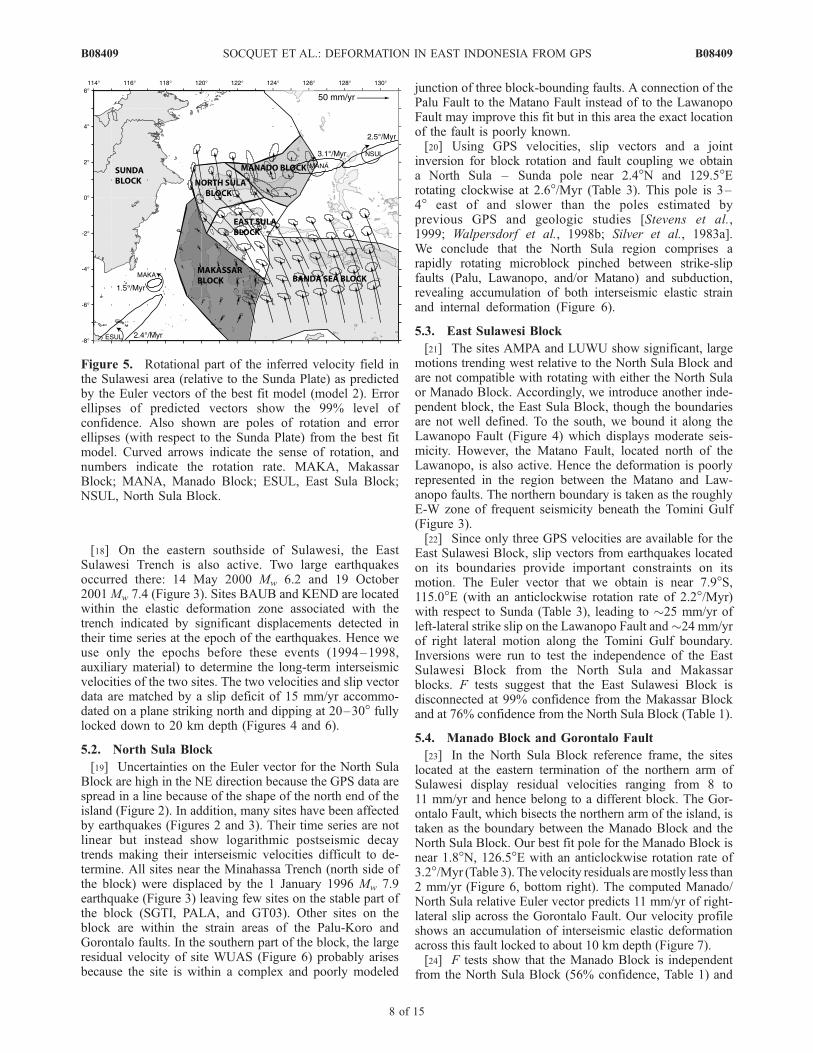
[19] Uncertainties on the Euler vector for the North SulaBlock are high in the NE direction because the GPS data arespread in a line because of the shape of the north end of theisland (Figure 2). In addition, many sites have been affectedby earthquakes (Figures 2 and 3). Their time series are notlinear but instead show logarithmic postseismic decaytrends making their interseismic velocities difficult to de-termine. All sites near the Minahassa Trench (north side ofthe block) were displaced by the 1 January 1996 Mw 7.9earthquake (Figure 3) leaving few sites on the stable part ofthe block (SGTI, PALA, and GT03). Other sites on theblock are within the strain areas of the Palu-Koro andGorontalo faults. In the southern part of the block, the largeresidual velocity of site WUAS (Figure 6) probably arisesbecause the site is within a complex and poorly modeled
junction of three block-bounding faults. A connection of thePalu Fault to the Matano Fault instead of to the LawanopoFault may improve this fit but in this area the exact locationof the fault is poorly known.[20] Using GPS velocities, slip vectors and a joint
inversion for block rotation and fault coupling we obtaina North Sula – Sunda pole near 2.4�N and 129.5�Erotating clockwise at 2.6�/Myr (Table 3). This pole is 3–4� east of and slower than the poles estimated byprevious GPS and geologic studies [Stevens et al.,1999; Walpersdorf et al., 1998b; Silver et al., 1983a].We conclude that the North Sula region comprises arapidly rotating microblock pinched between strike-slipfaults (Palu, Lawanopo, and/or Matano) and subduction,revealing accumulation of both interseismic elastic strainand internal deformation (Figure 6).
5.3. East Sulawesi Block
[21] The sites AMPA and LUWU show significant, largemotions trending west relative to the North Sula Block andare not compatible with rotating with either the North Sulaor Manado Block. Accordingly, we introduce another inde-pendent block, the East Sula Block, though the boundariesare not well defined. To the south, we bound it along theLawanopo Fault (Figure 4) which displays moderate seis-micity. However, the Matano Fault, located north of theLawanopo, is also active. Hence the deformation is poorlyrepresented in the region between the Matano and Law-anopo faults. The northern boundary is taken as the roughlyE-W zone of frequent seismicity beneath the Tomini Gulf(Figure 3).[22] Since only three GPS velocities are available for the
East Sulawesi Block, slip vectors from earthquakes locatedon its boundaries provide important constraints on itsmotion. The Euler vector that we obtain is near 7.9�S,115.0�E (with an anticlockwise rotation rate of 2.2�/Myr)with respect to Sunda (Table 3), leading to �25 mm/yr ofleft-lateral strike slip on the Lawanopo Fault and�24 mm/yrof right lateral motion along the Tomini Gulf boundary.Inversions were run to test the independence of the EastSulawesi Block from the North Sula and Makassarblocks. F tests suggest that the East Sulawesi Block isdisconnected at 99% confidence from the Makassar Blockand at 76% confidence from the North Sula Block (Table 1).
5.4. Manado Block and Gorontalo Fault
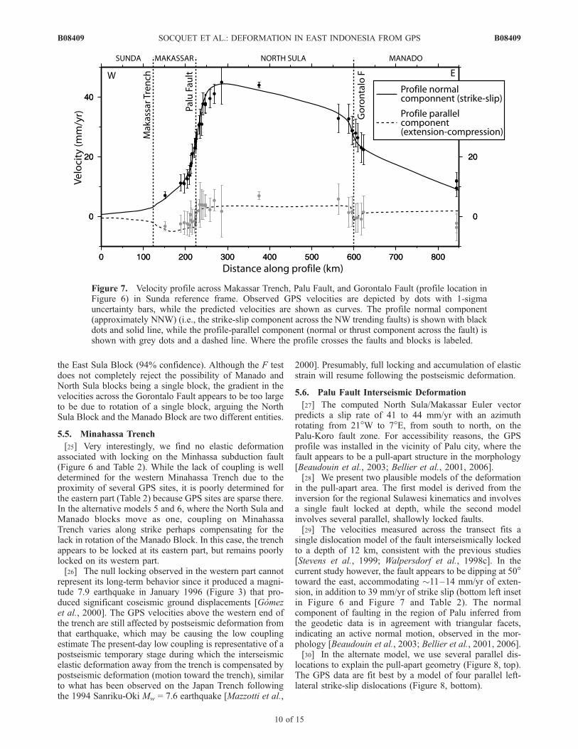
[23] In the North Sula Block reference frame, the siteslocated at the eastern termination of the northern arm ofSulawesi display residual velocities ranging from 8 to11 mm/yr and hence belong to a different block. The Gor-ontalo Fault, which bisects the northern arm of the island, istaken as the boundary between the Manado Block and theNorth Sula Block. Our best fit pole for the Manado Block isnear 1.8�N, 126.5�E with an anticlockwise rotation rate of3.2�/Myr (Table 3). The velocity residuals aremostly less than2 mm/yr (Figure 6, bottom right). The computed Manado/North Sula relative Euler vector predicts 11 mm/yr of right-lateral slip across the Gorontalo Fault. Our velocity profileshows an accumulation of interseismic elastic deformationacross this fault locked to about 10 km depth (Figure 7).[24] F tests show that the Manado Block is independent
from the North Sula Block (56% confidence, Table 1) and
Figure 5. Rotational part of the inferred velocity field inthe Sulawesi area (relative to the Sunda Plate) as predictedby the Euler vectors of the best fit model (model 2). Errorellipses of predicted vectors show the 99% level ofconfidence. Also shown are poles of rotation and errorellipses (with respect to the Sunda Plate) from the best fitmodel. Curved arrows indicate the sense of rotation, andnumbers indicate the rotation rate. MAKA, MakassarBlock; MANA, Manado Block; ESUL, East Sula Block;NSUL, North Sula Block.
B08409 SOCQUET ET AL.: DEFORMATION IN EAST INDONESIA FROM GPS
8 of 15
B08409
Figure 6. Best fit block model derived from both GPS and earthquakes slip vector azimuth data. Center:Observed (red) and calculated (green) velocities with respect to the Sunda Block (shown are 20%confidence ellipses, after GPS reweighting; see text). The slip rate deficit (mm/yr) for the faults includedin the model is represented by a color bar. The profile of Figure 7 is located by the dashed black line. Theblack rectangles around Palu and Gorontalo faults localize the insets. Top right and bottom left insetsshow details of the measured and modeled velocities across the Gorontalo and Palu faults. The bottomright inset shows residual GPS velocities with respect to the model. The value of the coupling ratio, j, forthe faults included in the model is represented by the color bar. Light blue dots represent the locations ofthe fault nodes where the coupling ratio is estimated. Nodes along the block boundaries are at the surfaceof the Earth, and the others are at depth along the fault plane. In this model, j is considered uniform alongstrike and depth for all the faults, except for Palu Fault and Minahassa Trench, where it is allowed to varyalong strike.
B08409 SOCQUET ET AL.: DEFORMATION IN EAST INDONESIA FROM GPS
9 of 15
B08409
the East Sula Block (94% confidence). Although the F testdoes not completely reject the possibility of Manado andNorth Sula blocks being a single block, the gradient in thevelocities across the Gorontalo Fault appears to be too largeto be due to rotation of a single block, arguing the NorthSula Block and the Manado Block are two different entities.
5.5. Minahassa Trench
[25] Very interestingly, we find no elastic deformationassociated with locking on the Minhassa subduction fault(Figure 6 and Table 2). While the lack of coupling is welldetermined for the western Minahassa Trench due to theproximity of several GPS sites, it is poorly determined forthe eastern part (Table 2) because GPS sites are sparse there.In the alternative models 5 and 6, where the North Sula andManado blocks move as one, coupling on MinahassaTrench varies along strike perhaps compensating for thelack in rotation of the Manado Block. In this case, the trenchappears to be locked at its eastern part, but remains poorlylocked on its western part.[26] The null locking observed in the western part cannot
represent its long-term behavior since it produced a magni-tude 7.9 earthquake in January 1996 (Figure 3) that pro-duced significant coseismic ground displacements [Gomezet al., 2000]. The GPS velocities above the western end ofthe trench are still affected by postseismic deformation fromthat earthquake, which may be causing the low couplingestimate The present-day low coupling is representative of apostseismic temporary stage during which the interseismicelastic deformation away from the trench is compensated bypostseismic deformation (motion toward the trench), similarto what has been observed on the Japan Trench followingthe 1994 Sanriku-Oki Mw = 7.6 earthquake [Mazzotti et al.,
2000]. Presumably, full locking and accumulation of elasticstrain will resume following the postseismic deformation.
5.6. Palu Fault Interseismic Deformation
[27] The computed North Sula/Makassar Euler vectorpredicts a slip rate of 41 to 44 mm/yr with an azimuthrotating from 21�W to 7�E, from south to north, on thePalu-Koro fault zone. For accessibility reasons, the GPSprofile was installed in the vicinity of Palu city, where thefault appears to be a pull-apart structure in the morphology[Beaudouin et al., 2003; Bellier et al., 2001, 2006].[28] We present two plausible models of the deformation
in the pull-apart area. The first model is derived from theinversion for the regional Sulawesi kinematics and involvesa single fault locked at depth, while the second modelinvolves several parallel, shallowly locked faults.[29] The velocities measured across the transect fits a
single dislocation model of the fault interseismically lockedto a depth of 12 km, consistent with the previous studies[Stevens et al., 1999; Walpersdorf et al., 1998c]. In thecurrent study however, the fault appears to be dipping at 50�toward the east, accommodating �11–14 mm/yr of exten-sion, in addition to 39 mm/yr of strike slip (bottom left insetin Figure 6 and Figure 7 and Table 2). The normalcomponent of faulting in the region of Palu inferred fromthe geodetic data is in agreement with triangular facets,indicating an active normal motion, observed in the mor-phology [Beaudouin et al., 2003; Bellier et al., 2001, 2006].[30] In the alternate model, we use several parallel dis-
locations to explain the pull-apart geometry (Figure 8, top).The GPS data are fit best by a model of four parallel left-lateral strike-slip dislocations (Figure 8, bottom).
Figure 7. Velocity profile across Makassar Trench, Palu Fault, and Gorontalo Fault (profile location inFigure 6) in Sunda reference frame. Observed GPS velocities are depicted by dots with 1-sigmauncertainty bars, while the predicted velocities are shown as curves. The profile normal component(approximately NNW) (i.e., the strike-slip component across the NW trending faults) is shown with blackdots and solid line, while the profile-parallel component (normal or thrust component across the fault) isshown with grey dots and a dashed line. Where the profile crosses the faults and blocks is labeled.
B08409 SOCQUET ET AL.: DEFORMATION IN EAST INDONESIA FROM GPS
10 of 15
B08409
[31] 1. The first dislocation is located along the westernside of the pull-apart, recognized by geologists as being theactive Palu Fault scarp [Beaudouin et al., 2003; Bellier etal., 2001, 2006]. It accommodates 13 mm/yr, and its lockingis between 2 and 5 km depth (Figure 6).
[32] 2. The second dislocation is 14 km east of this mainscarp, accommodates 10 mm/yr and is locked between 1and 5 km depth. This second dislocation, located along theeastern coast of the Palu Gulf, corresponds to the fault thatbounds the Palu pull-apart to the east. It separates Mio-Quaternary molasses from the metamorphic bedrock [Bellier
Figure 8. (top) GPS velocities in Palu area relative to station WATA. STRM topography is used asbackground. (bottom) Four parallel elastic dislocations that fit best the velocities in the Palu fault zone.The fault-parallel component of the GPS velocities (with 1-sigma error bars) is plotted with respect totheir distance to the main fault scarp, in the North Sula Block reference frame. The black curve representsthe fault-parallel modeled velocity of the four strand model. For comparison, the fault-parallel modeledvelocity predicted by the single fault model is also plotted (grey dashed curve). The location of themodeled dislocation is represented as vertical bars for each model (black and dashed grey lines,respectively).
B08409 SOCQUET ET AL.: DEFORMATION IN EAST INDONESIA FROM GPS
11 of 15
B08409
et al., 2006] and has been activated during the February 2005Mw = 6.3 earthquake (A. Soehaimi et al., personal communi-cation, 2006).[33] 3. The third dislocation is located 28 km from the
main scarp and accommodates 7 mm/yr. Its locking depthtends to zero, which is equivalent to a creeping behavior.The dislocation is near a steep gradient in topography thatcould correspond to a fault scarp. The abruptness of the stepin the velocities depends on the velocity determination ofthe sites SLBY and PL16 (measured 3 and 4 times,respectively).[34] 4. The three previous dislocations accommodate
30 mm/yr of the relative block motion. Another 8 mm/yrare missing and seem to be accommodated over a broadzone 50 km to the east. Dense GPS measurements aremissing to discriminate whether these 8 mm/yr arelocalized on one single dislocation or are distributed.Velocities are fit well by including a fourth dislocationlocked at 5–15 km depth and located �54 km east of themain scarp. The parameters of this last dislocation arepoorly constrained by three sites (DONG, SGTI, PALA)that are well to the north of Palu and span 1� in latitude.[35] The GPS inferred strike-slip rate (39 mm/yr) for the
Palu Fault agrees with the long-term slip rate (35 ± 8 mm/yr)determined from stream and fan offsets, mainly seen in thequaternary deposits along thewestern border of the Palu basin[Bellier et al., 2001]. This long-term slip rate, ranging from 5to 51 mm/yr [Bellier et al., 2001], argues for the singledislocation model at its high end, although the alternate localmodel, that predicts 13 mm/yr on the western branch of thefault, is also within the long-term range. South of the Palubasin, where the fault trace is more linear and appears to forma single trace, Bellier et al. [2001] obtain a slip rate of 29 ±5 mm/yr. This rate might either correspond to the ‘‘singlestrand model’’ or to the 30 mm/yr (13 + 10 + 7) of totalamount taken on the three western dislocations of the‘‘multiple strand model.’’[36] In terms of seismicity, preliminary paleoseismolog-
ical studies reveal three 6.8 < Mw < 8 earthquakes over thelast 2000 years [Bellier et al., 2001], implying a cumulativeoffset of �30 meters [Wells and Coppersmith, 1994]. Theseearthquakes occurred on the main branch of the fault,western side of the pull-apart. The measured cumulativeoffset matches quite well the 26 meters of cumulative offsetpredicted by the multiple strand model on the westerndislocation. Low slip on the western strand reconciles thefact that although the paleoseismicity is small, the fault isinterseismically locked and releases its strain through earth-quakes. If the multiple strands model is accurate, additionalpaleoseismic studies on the secondary branches of the PaluFault should be performed to sample more completely thepaleoseismicity, and hence assess the complete seismichazard of the fault zone. However, because paleoseismo-logical studies are able to detect only the larger earthquakeevents (Mw � 6.5 and above), there may be other smallerones contributing to a slip rate. Paleoseismology is mostlikely slightly underestimating the rate. It is also possiblethat there could be periodic aseismic slip on this fault(postseismic, or episodic slow slip?), so the paleoseismol-ogy underestimates the slip rates even more if those occur. Ifthat is the case, the single Palu Fault model might be moreaccurate (rather than the three to four strands). However,
small earthquakes (Mw < 6) should be numerous to contrib-ute significantly to a slip rate (one every 1 or 2 years on the150 km long Palu segment), which is not observed in theinstrumental seismicity. Strong geomorphic evidence of apull-apart in this area combined with the recent seismicactivity of the east branch of the pull-apart pleads for themultiple strand model. Therefore we consider that the ‘‘one-dislocation’’ model is a good large-scale approximation(good enough when dealing with block rotations over along period of time for example) but that a refined modelwith more dislocations is needed by geodetic, geomorphicand seismologic data when dealing with local fault behaviorand assessing the seismic hazard. These scenarios are notequally probable, they happen at the same time: in this area,a transtensive motion occurs on the fault system, which isprobably divided into several active branches (each side ofthe pull-apart), that may be regarded as surface splays of astrike-slip flower structure.
6. Conclusion and Outlooks
6.1. Kinematics of the Triple Junction and PossibleMechanisms Driving the Microblock Rotations
[37] Sulawesi is located at the western termination of theboundary between Australia and Philippine/Pacific plates.This boundary accommodates the left lateral oblique con-vergence by rapid microblocks rotations in Papua NewGuinea [Bock et al., 2003; Pubellier and Ego, 2002;Pubellier et al., 1996; McCaffrey and Abers, 1991; Stevenset al., 2002; Wallace et al., 2004] and slip partitioningfurther west (between normal subduction at the TimorTrough and strike slip on the Sula-Sorong Fault, Figure 1).Movements of crustal fragments within this E-W orientedcomplex boundary zone results in local collisions with theSunda Plate in the area of Sulawesi and Borneo. Because ofthe rapid westward motion of the Philippine Sea Plate, theSula-Sorong Fault slips left laterally. It ends in Sulawesi(there called Matano/Palu-Koro Fault), where it separatesthe island in two parts. The southern blocks of the study area(Makassar, Banda Sea and East Sula blocks, Figure 5) rotateanticlockwise, which is consistent with a left lateral sense ofshear. The northern parts of Sulawesi however (North Sulaand Manado blocks) rotate clockwise: the North Sula Blockrotates quickly, while the Manado Block is swept along thelatter and rotates at a slower rate (relative to the fixed SundaBlock).[38] We suggest that the clockwise tectonic block rotation
in the northern part of Sulawesi occurs due to the change inboundary condition around the North Sula Block. To thewest the Sulawesi Island is bound by buoyant Borneocontinental crust, while oceanic crust bounds the island tothe north (Celebes Sea) and to the east (Banda Sea).Because of its thick, buoyant crust, the Borneo lithosphereresists subduction below Sulawesi. Such buoyancy forceshave been termed ‘‘colliding resistance’’ forces [Forsythand Uyeda, 1975]. This collision inhibits rapid convergencebetween Borneo and Sulawesi but results in slow deforma-tion of the eastern margin of Borneo island. Conversely, thepresence of oceanic crust north and east of Sulawesifacilitates subduction. North of Sulawesi at the MakassarTrench, ‘‘trench suction’’ forces [Elsasser, 1971; Forsythand Uyeda, 1975; Chapple and Tullis, 1977; Chase, 1978]
B08409 SOCQUET ET AL.: DEFORMATION IN EAST INDONESIA FROM GPS
12 of 15
B08409
allow the extrusion of material toward the north. Thewestward motion of the northern part of Sulawesi is hencemore easily accommodated by a clockwise rotation of theNorth Sula Block than by mountain building, since arelatively low stress boundary exists toward the north.The same kind of process has been invoked in other places(e.g., westward extrusion of the Bird’s Head Block inwestern Papua [Pubellier and Ego, 2002; McCaffrey andAbers, 1991; Stevens et al., 2002] or extrusion models forthe deformation of Asia in response to the Indian indenter[e.g., Tapponnier et al., 1982]). Similarly, the decrease ofthe motion from the Banda Sea Block to the MakassarBlock might not only be due to a westward decreasing left-lateral shear but also to collision of the Makassar Block withBorneo continental crust. These ‘‘colliding resistance’’forces would cause the E-W convergence to be insteadaccommodated on the East Sulawesi Trench, where theBanda Sea oceanic crust can easily subduct under theMakassar Block’s continental lithosphere.
6.2. Interseismic Behavior of Faults
[39] The Sulawesi microblocks are surrounded by activefaults that produce elastic deformation inside them. Wemonitored two active strike-slip faults in the region ofSulawesi using two dense local GPS networks. The Gor-ontalo Fault appears to be active although little seismicity isevident in this area. The fault accommodates 11 mm/yr indextral transtension and is locked to about 10 km depth. ThePalu Koro Fault zone accommodates 42 mm/yr and shows atranstensive behavior more complex than the simple strikeslip commonly described (39 mm/yr of left-lateral strike slipassociated with �11–14 mm/yr of extension). This defor-mation is most likely explained by the presence of a pull-apart structure that may be localized around the Palu area.We present here two models that can explain the deforma-tion in this area. The first model is a good large-scaleapproximation and involves one single transtensive fault,while the second involves three closely spaced (�14 kmapart) faults with shallow locking depths accommodating atotal amount of 30 mm/yr, the remaining motion beingaccommodated 50 km to the east. That refined threedislocation model has important consequences concerningthe seismic hazard: the coexistence of three dislocationswith very shallow locking depths may explain the deficit ofpaleoseismicity on the one studied surface trace of the fault.The GPS inferred slip rate agrees with the long-term sliprate determined from stream and fan offsets [Bellier et al.,2001]. The Lawanopo/Matano Fault zone, extending fromthe Palu Fault toward the south, is probably coupled in theinterseismic period. It is still poorly known which of thesefaults is the southern continuation of the Palu Fault.Sulawesi is surrounded by three active trenches. The EastSulawesi Trench accommodates the motion between theBanda Sea and the Makassar Block. This trench is affectedby periodic earthquakes between which strain is accumu-lated above the locked subduction plane. To explain ourmeasured velocities properly, another locked fault must belocated in the Makassar Strait. Finally, the MinahassaTrench bounds the island to the north and accommodatesthe motion of the North Sula Block relative to the SundaPlate. We find here a null coupling for this trench that hasgenerated very large subduction earthquakes in the recent
past [Gomez et al., 2000]. Hence this absence of loadingcannot represent the regular interseismic behavior of thetrench and is certainly a transient state maybe due toafterslip following a recent seismic event [Mazzotti et al.,2000].
6.3. Limitations of the Model
[40] To fully represent the interseismic deformation, thetime series of the sites affected by earthquakes should beanalyzed in terms of transient displacements, coseismicjumps and postseismic deformation. Beyond its crucialinterest for a better understanding of the earthquake cycle,such modeling can also allow better determination of theinterseismic velocity required for kinematic studies. How-ever, constraining coseismic and postseismic deformationrequires long and dense (temporally and spatially) timeseries (ideally, those provided by permanent GPS stations)that are still missing at most sites.[41] The current model explains the data and describes
the kinematics and the behavior of the active structuresaround Sulawesi. Given the sparseness of the data, theinterseismic coupling on several of the faults should onlybe taken as a first approximation. However, the deformationaround Palu and Gorontalo faults is accurately modeled.Our detailed analysis in the Palu area revealed severalsubsurface splays of the fault unknown prior to this study.
[42] Acknowledgments. This work is a continuation of the jointresearch activities in SE Asia, which were initiated by the GEODYSSEAproject. Thanks and appreciation are extended to all people who havecontributed significantly in expanding the GPS database on SE Asia. Wewould like to thank especially all the staff and students at the Geodesydepartment of the Institut Teknologi Bandung and the Geodynamicsdivision of the National Coordination Agency for Surveys and Mapping(BAKOSURTANAL) in Indonesia for their contribution to the GPSmeasurements in Sulawesi. GPS activities in Indonesia were supportedby the Dutch Integrated Solid Earth Science (ISES) research program, theFrench Embassy in Indonesia (Service de Cooperation et d’Action Cultur-elles), and the French Ministry of Research (through the ACI ‘‘Observationde la Terre’’ research program). McCaffrey’s participation was supported byENS and Rensselaer Polytechnic Institute. Finally, the authors wish to thankthe Jet Propulsion Laboratory for their support and advice on using theGIPSY-OASIS GPS software. This paper benefited from very constructivereviews (M. Keep, L. M. Wallace, and an anonymous Associate Editor). Wewant to express special thanks to L. M. Wallace for her extremely long,detailed, and thorough analysis of our work. The maps in this paper wereproduced using the public domain Generic Mapping Tools (GMT) software[Wessel and Smith, 1995].
ReferencesAltamimi, Z., P. Sillard, and C. Boucher (2002), ITRF2000: A new releaseof the International Terrestrial Reference Frame for earth science applica-tions, J. Geophys. Res., 107(B10), 2214, doi:10.1029/2001JB000561.
Aurelio, M. A. (2000), Shear partitioning in the Philippines: Constraintsfrom Philippine Fault and global positioning system data, Island Arc, 9,584–597.
Barrier, E., P. Huchon, and M. Aurelio (1991), Philippine Fault—A key forPhilippine kinematics, Geology, 19, 32–35.
Beaudouin, T., O. Bellier, and M. Sebrier (2003), Present-day stress anddeformation fields within the Sulawesi Island area (Indonesia): Geody-namic implications, Bull. Soc. Geol. Fr., 174, 305–317.
Bellier,O.,M. Sebrier, T.Beaudouin,M.Villeneuve,R.Braucher,D.Bourles,L. Siame, E. Putranto, and I. Pratomo (2001), High slip rate for a lowseismicity along the Palu-Koro active fault in central Sulawesi (Indonesia),Terra Nova, 13, 463–470.
Bellier, O., M. Sebrier, D. Seward, T. Beaudouin, M. Villeneuve, andE. Putranto (2006), Fission track and fault kinematics analyses for newinsight into the Late Cenozoic tectonic regime changes in west-centralSulawesi (Indonesia), Tectonophysics, 413, 201–220.
Blewitt, G., et al. (1988), GPS geodesy with centimeter accuracy, in LectureNotes in Earth Sciences, vol. 19, edited by E. Groten and R. Strauss,pp. 30–40, Springer, New York.
B08409 SOCQUET ET AL.: DEFORMATION IN EAST INDONESIA FROM GPS
13 of 15
B08409
Bock, Y., L. Prawirodirdjo, J. F. Genrich, C. W. Stevens, R. McCaffrey,C. Subarya, S. S. O. Puntodewo, and E. Calais (2003), Crustal motionin Indonesia from Global Positioning System measurements, J. Geo-phys. Res., 108(B8), 2367, doi:10.1029/2001JB000324.
Calmant, S., B. Pelletier, P. Lebellegard, M. Bevis, F. W. Taylor, andD. Phillips (2003), New insights on the tectonics along the NewHebrides subduction zone based on GPS results, J. Geophys. Res.,108(B6), 2319, doi:10.1029/2001JB000644.
Chamot-Rooke, N., and X. Le Pichon (1999), GPS determined eastwardSundaland motion with respect to Eurasia confirmed by earthquakes slipvectors at Sunda and Philippine trenches, Earth Planet. Sci. Lett., 173,439–455.
Chapple, W. M., and T. E. Tullis (1977), Evaluation of the forces that drivethe plates, J. Geophys. Res., 82, 1967–1984.
Chase, C. G. (1978), Extension behind island arcs and motions relative tohot spots, J. Geophys. Res., 83, 5385–5387.
DeMets, C., R. Gordon, D. Argus, and S. Stein (1990), Current plate mo-tions, Geophys. J. Int., 101, 425–478.
DeMets, C., R. G. Gordon, D. F. Argus, and S. Stein (1994), Effect ofrecent revisions to the geomagnetic reversal time scale on estimates ofcurrent plate motions, Geophys. Res. Lett., 21(20), 2191–2194.
Elsasser, W. M. (1971), Sea-floor spreading as thermal convection, J. Geo-phys. Res., 76, 1101–1112.
Fitch, T. J. (1972), Plate convergence, transcurrent faults, and internaldeformation adjacent to Southeast Asia and western Pacific, J. Geophys.Res., 77, 4432–4460.
Fitch, T. J., and W. Hamilton (1974), Reply to comment by M. G. Audley-Charles and J. Milsomon on ‘‘Plate convergence, transcurrent faults, andinternal deformation adjacent to Southeast-Asia and western Pacific,’’J. Geophys. Res., 79, 4982–4985.
Forsyth, D., and S. Uyeda (1975), On the relative importance of the drivingforces of plate motion, Geophys. J. R. Astron. Soc., 43, 163–200.
Genrich, J. F., Y. Bock, R. McCaffrey, E. Calais, C. W. Stevens, andC. Subarya (1996), Accretion of the southern Banda arc to the Aus-tralian plate margin determined by Global Positioning System mea-surements, Tectonics, 15, 288–295.
Genrich, J. F., Y. Bock, R. McCaffrey, L. Prawirodirdjo, C. W. Stevens,S. S. O. Puntodewo, C. Subarya, and S. Wdowinski (2000), Distribu-tion of slip at the northern Sumatran fault system, J. Geophys. Res.,105, 28,327–28,342.
Gomez, J. M., R. Madariaga, A. Walpersdorf, and E. Chalard (2000), The1996 earthquakes in Sulawesi, Indonesia, Bull. Seismol. Soc. Am., 90,739–751.
Hall, R. (2002), Cenozoic geological and plate tectonic evolution of SEAsia and the SW Pacific: Computer-based reconstructions, model andanimations, J. Asian Earth Sci., 20, 353–431.
Hall, R., and M. E. J. Wilson (2000), Neogene sutures in eastern Indonesia,J. Asian Earth Sci., 18, 781–808.
Hamilton, W. B. (1972), Plate tectonics of Southeast Asia and Indonesia,Am. Assoc. Pet. Geol. Bull., 56, 621.
Hamilton, W. (1979), Tectonics of the Indonesian region, U.S. Geol. Surv.Prof. Pap., 1078, 345 pp. + map.
Hinschberger, F., J.-A. Malod, J.-P. Rehault, J. Dyment, C. Honthaas,M. Villeneuve, and S. Burhanuddin (2000), Origin and evolution of theNorth Banda Basin (Indonesia): Constraints from magnetic data, C. R.Acad. Sci., Ser. Fasc. Sci. Terre Planetes, 331, 507–514.
Kato, T., J. Beavan, T. Matsushima, Y. Kotake, J. T. Camacho, and S. Nakao(2003), Geodetic evidence of back-arc spreading in the Mariana Trough,Geophys. Res. Lett., 30(12), 1625, doi:10.1029/2002GL016757.
Kreemer, C., W. E. Holt, S. Goes, and R. Govers (2000), Active deforma-tion in eastern Indonesia and the Philippines from GPS and seismicitydata, J. Geophys. Res., 105, 663–680.
Mader, G. L. (1998), GPS Antenna calibration at the National GeodeticSurvey, technical report, Natl. Geod. Surv., Silver Spring, Md.
Mazzotti, S., X. Le Pichon, P. Henry, and S. Miyazaki (2000), Full inter-seismic locking of the Nankai and Japan-west Kurile subduction zones:An analysis of uniform elastic strain accumulation in Japan constrainedby permanent GPS, J. Geophys. Res., 105, 13,159–13,177.
McCaffrey, R. (1995), DEFNODE users’ guide, Rensselaer Polytech. Inst.,Troy, N. Y. (Available at http://www.rpi.edu/�mccafr/defnode)
McCaffrey, R. (2002), Crustal block rotations and plate coupling, inPlate Boundary Zones, Geodyn. Ser., vol. 30, edited by S. Stein andJ. Freymueller, pp. 101–122, AGU, Washington, D. C.
McCaffrey, R. (2005), Block kinematics of the Pacific–North Americaplate boundary in the southwestern United States from inversion ofGPS, seismological, and geologic data, J. Geophys. Res., 110, B07401,doi:10.1029/2004JB003307.
McCaffrey, R., and G. A. Abers (1991), Orogeny in arc-continentcollision: the Banda Arc and western New-Guinea, Geology, 19,563–566.
McCaffrey, R., M. D. Long, C. Goldfinger, P. C. Zwick, J. L. Nabelek, C. K.Johnson, and C. Smith (2000), Rotation and plate locking at thesouthern Cascadia subduction zone, Geophys. Res. Lett., 27, 3117–3120.
Michel, G. W., et al. (2001), Crustal motion and block behaviour in SE-Asia from GPS measurements, Earth Planet. Sci. Lett., 187, 239–244.
Morgan, W. J. (1968), Rises, trenches, great faults, and crustal blocks,J. Geophys. Res., 73, 1959–1982.
Okada, Y. (1985), Surface deformation due to shear and tensile faults in ahalf-space, Bull. Seism. Soc. Am., 75, 1135–1154.
Okada, Y. (1992), Internal deformation due to shear and tensile faults in ahalf-space, Bull. Seismol. Soc. Am., 82, 1018–1040.
Peltzer, G., and F. Saucier (1996), Present-day kinematics of Asia derivedfrom geologic fault rates, J. Geophys. Res., 101, 27,943–27,956.
Prawirodirdjo, L., et al. (1997), Geodetic observations of interseismic strainsegmentation at the Sumatra subduction zone, Geophys. Res. Lett., 24,2601–2604.
Prawirodirdjo, L., Y. Bock, J. F. Genrich, S. S. O. Puntodewo, J. Rais,C. Subarya, and S. Sutisna (2000), One century of tectonic deformationalong the Sumatran Fault from triangulation and GPS surveys, J. Geophys.Res., 105, 28,343–28,361.
Press, W. H., B. P. Flannery, S. A. Teukolsky, and W. T. Vetterling (1989),Numerical Recipes, Cambridge Univ. Press, New York.
Pubellier, M., and F. Ego (2002), Anatomy of an escape tectonic zone:Western Irian Jaya (Indonesia), Tectonics, 21(4), 1019, doi:10.1029/2001TC901038.
Pubellier, M., G. Girardeau, H. Permana, B. Deffontaines, M. Pubellier, andC. Rangin (1996), Escape tectonics during and after collision in westernIrian Jaya, Indonesia, Eos Trans. AGU, 77(46), Fall Meet. Suppl., F654.
Puntodewo, S. S. O., R. McCaffrey, E. Calais, Y. Bock, J. Rais, C. Subarya,R. Poewariardi, C. Stevens, Fauzi, J. Genrich, and P. Zwick (1994), GPSmeasurements of crustal deformation within the Pacific-Australia Plateboundary zone in Irian Jaya, Indonesia, Tectonophysics, 237, 141–153.
Rangin, C. (1989), The Sulu Sea, a back-arc basin setting within a Neogenecollision zone, Tectonophysics, 161, 119–141.
Rangin, C., X. Le Pichon, S. Mazzotti, M. Pubellier, N. Chamot-Rooke,M. Aurelio, A. Walpersdorf, and R. Quebral (1999), Plate convergencemeasured by GPS across the Sundaland/Philippine Sea Plate deformedboundary; the Philippines and eastern Indonesia, Geophys. J. Int., 139,296–316.
Savage, J. C. (1983), A dislocation model of strain accumulation and re-lease at a subduction zone, J. Geophys. Res., 88, 4984–4996.
Savage, J. C., and R. O. Burford (1973), Geodetic determination of re-lative plate motion in central California, J. Geophys. Res., 78, 832–845.
Scherneck, H.-G. (1991), A parametrized solid Earth tide mode and oceanloading effects for global geodetic base-line measurements, Geophys.J. Int., 106, 677–694.
Silver, E. A., and J. C. Moore (1978), Molucca Sea Collision Zone, In-donesia, J. Geophys. Res., 83, 1681–1691.
Silver, E. A., R. McCaffrey, and R. B. Smith (1983a), Collision, rotation,and the initiation of subduction in the evolution of Sulawesi, Indonesia,J. Geophys. Res., 88, 9407–9418.
Silver, E. A., R. McCaffrey, Y. Joyodiwiryo, and S. Stevens (1983b),Ophiolite emplacement by collision between the Sula Platform and theSulawesi Island-Arc, Indonesia, J. Geophys. Res., 88, 9419–9435.
Simons,W. J. F., B. A. C. Ambrosius, R. Noomen, D. Angermann, P.Wilson,M. Becker, E. Reinhart, A. Walpersdorf, and C. Vigny (1999), Observingplate motions in S.E. Asia: Geodetic results of the GEODYSSEA project,Geophys. Res. Lett., 26, 2081–2084.
Simons, W. J. F., D. L. F. van Loon, A. Walpersdorf, B. A. C. Ambrosius,J. Kahar, Z. H. Abidin, D. A. Sarsito, C. Vigny, S. Haji Abu, andP. Morgan (2000), Geodynamics of the S.E. Asia: First results of theSulawesi 1998 GPS campaign, in Geodesy Beyond 2000: The Challengesof the First Decade: IAG General Assembly, Birmingham, July 19–30,1999, Int. Assoc. Geod. Symp., vol. 121, edited by K.-P. Schwarz,pp. 271–277, Springer, New York.
Socquet, A., C. Vigny, N. Chamot-Rooke, W. Simons, C. Rangin, andB. Ambrosius (2006), India and Sunda plates motion and deformationalong their boundary in Myanmar determined by GPS, J. Geophys.Res., 111, B05406, doi:10.1029/2005JB003877.
Stevens, C., R. McCaffrey, Y. Bock, J. Genrich, Endang, C. Subarya, S. S. O.Puntodewo, Fauzi, and C. Vigny (1999), Rapid rotations about a verticalaxis in a collisional setting revealed by the Palu Fault, Sulawesi, Indonesia,Geophys. Res. Lett., 26, 2677–2680.
Stevens, C. W., R. McCaffrey, Y. Bock, J. F. Genrich, M. Pubellier, andC. Subarya (2002), Evidence for block rotations and basal shear inthe world’s fastest slipping continental shear zone in NW New Guinea,in Plate Boundary Zones, Geodyn. Ser., vol. 30, edited by S. Stein andJ. Freymueller, pp. 87–99, AGU, Washington, D. C.
B08409 SOCQUET ET AL.: DEFORMATION IN EAST INDONESIA FROM GPS
14 of 15
B08409
Tapponnier, P., G. Peltzer, A. Y. Le Dain, R. Armijo, and P. Cobbold(1982), Propagating extrusion tectonics in Asia: New insights from sim-ple experiments with plasticene, Geology, 10, 611–616.
Tregoning, P., F. K. Brunner, Y. Bock, S. S. O. Puntodewo, R. McCaffrey,J. F. Genrich, E. Calais, J. Rais, and C. Subarya (1994), First geodeticmeasurement of convergence across the Java Trench, Geophys. Res.Lett., 21, 2135–2138.
Tregoning, P., et al. (1998), Estimation of current plate motions in PapuaNew Guinea from Global Positioning System observations, J. Geophys.Res., 103, 12,181–12,204.
Tregoning, P., R. J. Jackson, H. McQueen, K. Lambeck, C. Stevens, R. P.Little, R. Curley, and R. Rosa (1999), Motion of the South BismarckPlate, Papua New Guinea, Geophys. Res. Lett., 26, 3517–3520.
Tregoning, P., H. McQueen, K. Lambeck, R. Jackson, R. Little, S. Saunders,and R. Rosa (2000), Present-day crustal motion in Papua New Guinea,Earth Planets Space, 52, 727–730.
Vigny, C., et al. (2002), Migration of seismicity and earthquake interac-tions monitored by GPS in SE Asia triple junction: Sulawesi, Indonesia,J. Geophys. Res., 107(B10), 2231, doi:10.1029/2001JB000377.
Wallace, L. M., C. Stevens, E. Silver, R. McCaffrey,W. Loratung, S. Hasiata,R. Stanaway, R. Curley, R. Rosa, and J. Taugaloidi (2004), GPS and seis-mological constraints on active tectonics and arc-continent collision inPapua New Guinea: Implications for mechanics of microplate rotationsin a plate boundary zone, J. Geophys. Res., 109, B05404, doi:10.1029/2003JB002481.
Wallace, L. M., R. McCaffrey, J. Beavan, and S. Ellis (2005), Rapid micro-plate rotations and backarc rifting at the transition between collision andsubduction, Geology, 33(11), 857–860, doi:10.1130/G21834.1.
Walpersdorf, A., C. Rangin, and C. Vigny (1998a), GPS compared to long-term geologic motion of the north arm of Sulawesi, Earth Planet. Sci.Lett., 159, 47–55.
Walpersdorf, A., C. Vigny, P. Manurung, C. Subarya, and S. Sutisna(1998b), Determining the Sula Block kinematics in the triple junctionarea in Indonesia by GPS, Geophys. J. Int., 135, 351–361.
Walpersdorf, A., C. Vigny, C. Subarya, and P. Manurung (1998c), Monitor-ing of the Palu-Koro Fault (Sulawesi) by GPS, Geophys. Res. Lett., 25,2313–2316.
Weissel, J. K., and R. N. Anderson (1978), Is there a Caroline Plate, EarthPlanet. Sci. Lett., 41, 143–158.
Wells, D. L., and K. J. Coppersmith (1994), New empirical relationshipsamong magnitude, rupture length, rupture width, rupture area, and sur-face displacement, Bull. Seismol. Soc. Am., 84, 974–1002.
Wessel, P., and W. H. F. Smith (1995), New version of the generic mappingtools released, Eos Trans. AGU, 76(33), 329.
�����������������������B. Ambrosius and W. Simons, DEOS, Delft University of Technology,
Kluyverweg 1, Delft, ZH NL-2629 HS, Netherlands.R. McCaffrey, Department of Earth and Environmental Sciences, RPI,
110 8th St., Troy, NY 12180-3590, USA.D. Sarsito, Geodesy Research Group, Faculty of Civil and Environmental
Engineering, Institute of Technology Bandung, Jl. Ganesha 10, Bandung40132, Indonesia.A. Socquet, Department of Earth and Space Sciences, University of
California, 595 Charles E. Young Drive East, Los Angeles, CA 90095-0000, USA. ([email protected])W. Spakman, Faculty of Earth Sciences, Utrecht University, Budapes-