Acknowledgement This material is based upon work supported by the Department of Energy under Award Number DE-FE0026087. The Project Team is led by Battelle and includes the state geological surveys of Delaware, Maryland, and Pennsylvania; United States Geological Survey; Lamont-Doherty Earth Observatory at Columbia University; and Rutgers University. In addition, Harvard University, Texas Bureau of Economic Geology, and Virginia Department of Mines, Minerals, & Energy serve as technical advisors.
2
This report was prepared as an account of work sponsored by an agency of the United States Government. Neither the United States Government nor any agency thereof, nor any of their employees, makes any warranty, express or implied, or assumes any legal liability or responsibility for the accuracy, completeness, or usefulness of any information, apparatus, product, or process disclosed, or represents that its use would not infringe privately owned rights. Reference herein to any specific commercial product, process, or service by trade name, trademark, manufacturer, or otherwise does not necessarily constitute or imply its endorsement, recommendation, or favoring by the United States Government or any agency thereof. The views and opinions of authors expressed herein do not necessarily state or reflect those of the United States Government or any agency thereof.
3
Disclaimer
A brief project overview will be provided • Background
§ Why is the project important?
§ What is special about the study area?
§ What is a carbon storage resource assessment?
• Project Scope § What are the project’s objectives?
§ How will they be achieved?
§ What are the schedule and deliverables?
• Discussion § What progress has been made?
§ What does the future hold?
4
Why is the project important? Very few scenarios achieve climate goals without CCS
2050
Nuclear 8%
Power generation efficiency
End-use fuel switching 12%
CCS 14% End-use efficiency 42%
Renewables 21%
Source: IEA Energy Technology Perspectives 2014
2Ds
6Ds
& Fuel switching 3%
• CCS technology tested & ready for large-scale deployment
• In need of economic &/or policy drivers
5
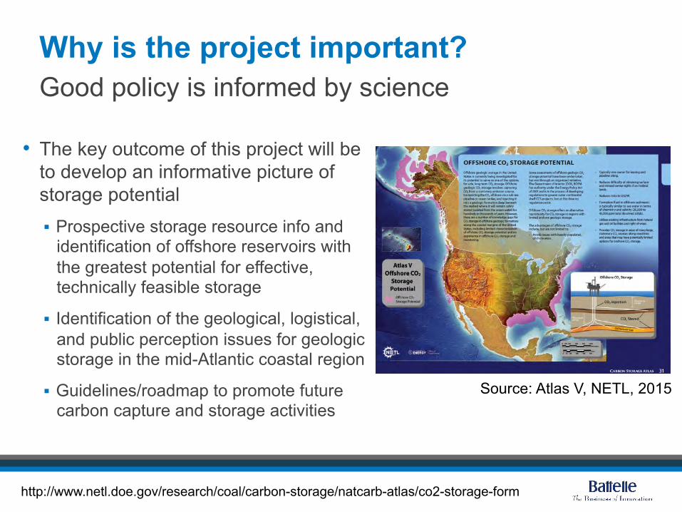
Why is the project important?
• The key outcome of this project will be to develop an informative picture of storage potential § Prospective storage resource info and
identification of offshore reservoirs with the greatest potential for effective, technically feasible storage
§ Identification of the geological, logistical, and public perception issues for geologic storage in the mid-Atlantic coastal region
§ Guidelines/roadmap to promote future carbon capture and storage activities
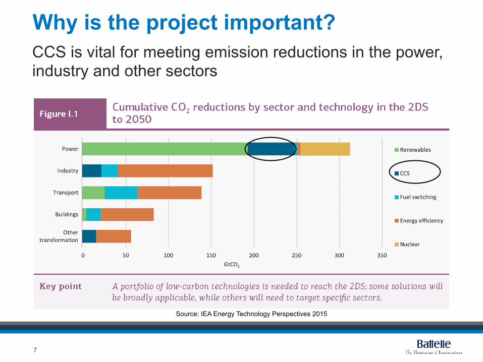
Why is the project important? CCS is vital for meeting emission reductions in the power, industry and other sectors
Source: IEA Energy Technology Perspectives 2015
7
What is special about the study area?
• Addresses heavily populated Mid-Atlantic States: Virginia, Maryland, Delaware, New Jersey, Pennsylvania, New York
• Potential storage within the mid- and north-Atlantic Planning Areas
Characterized by numerous point sources which could be matched to storage
8
What is special about the study area? Includes three major sub regions
9
Mid-Atlantic U.S. Offshore Carbon Storage Resource Study Area
1
3
2
1. Georges Bank Basin
2. Baltimore Canyon Trough
3. Long Island Platform
9
What is special about the study area? Synergistic with MRCSP projects
Collaborative geologic storage potential mapping with state geological surveys and universities
10
MRCSP's geology team
What is a carbon storage resource assessment? Defining Terminology & Classification Systems
US-DOE-NETL, 2010
CSLF, 2008
IEAGHG, 2008
11
What is a carbon storage resource assessment?
CO2 Storage Resource: The pore volume of a potential storage formation that is accessible to injected CO2 via drilled and complete wellbores. Can have subset of qualifiers (e.g. Theoretical, Effective, Prospective, Contingent). Exploration phase
Resource vs Capacity
CO2 Storage Capacity: Quantity of CO2 that can be commercially stored in a formation in a given timeframe under specific economic & regulatory constraints such as: land use, field/operational conditions, costs, proximity to CO2 source. Implementation phase
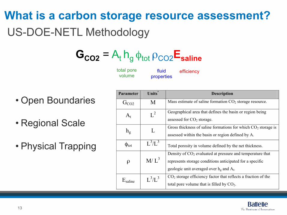
What is a carbon storage resource assessment? US-DOE-NETL Methodology
GCO2 = At hg φtot ρCO2Esaline
• Open Boundaries
• Regional Scale
• Physical Trapping
Parameter Units* Description
GCO2 M Mass estimate of saline formation CO2 storage resource.
At L2 Geographical area that defines the basin or region being
assessed for CO2 storage.
hg L Gross thickness of saline formations for which CO2 storage is
assessed within the basin or region defined by A.
φtot L3/L3 Total porosity in volume defined by the net thickness.
ρ M/ L3 Density of CO2 evaluated at pressure and temperature that
represents storage conditions anticipated for a specific
geologic unit averaged over hg and At.
Esaline L3/L3 CO2 storage efficiency factor that reflects a fraction of the
total pore volume that is filled by CO2.
total pore volume
fluid properties
efficiency
13
What are the project objectives?
Carbon Storage Program Goal
Mid-Atlantic U.S. Project Objectives
Support industry’s ability to predict CO2 storage capacity
Define the geologic characteristics of candidate storage sites
Use seismic data to better define continuity of reservoirs and seals
Catalog hydrologic properties of mid-Atlantic offshore storage sites
Determine appropriate efficiency parameters specific to offshore lithology
Develop Best Practice Manuals
Examine risk factors
Engage stakeholders to guide future projects
14
Project objectives are aligned with DOE goals
How will the objectives be achieved? Diverse, qualified project team
Project Management (Task1)
Project Manager: Lydia Cumming Principal Investigator: Neeraj Gupta
Task 2
Offshore Geological
Characterization
Ken Miller (Rutgers)
Task 3
Seismic Evaluation
Greg Mountain (Rutgers)
Task 4
Hydrologic Properties
Characterization
Peter McLaughlin (Delaware
Geo. Survey)
Task 5
Carbon Resource Calculations
Isis Fukai (Battelle)
Task 6
Risk Factor Analysis
Joel Sminchak
(Battelle)
Sponsors
DOE
Technical Advisory Committee
Daniel Schrag (Harvard) Tip Meckel (BEG)
David Spears (Virginia)
Project Lead
Task 8
Reporting & Tech Transfer
Lydia Cumming (Battelle)
Task 7
Stakeholder Education & Engagement
Kristin Carter (Pennsylvania Geo. Survey)
15
How will project objectives be achieved?
• Compilation and review of all existing available data
• Construction of a digital database
• Interpretation of porosity and mineralogy using well logs and core
• Correlation and calibration of seismic data with well log data
• Construction of new storage and seal formation maps and cross-sections
Define the geologic characteristics of candidate storage sites
From Brian Slater, Stolorow, and Smith, 2011
16
How will project objectives be achieved? Use seismic data to better define continuity of reservoirs and seals
17
Locations of wells and seismic profiles compiled by the USGS and available for analysis (Source: USGS)
• BOEM newly released industry multichannel seismic data from 70-80s
• Augmented with lines from USGS and academia
• Dense data grid of 2-D seismic reflection lines on shelf and slope from Cape Hatteras to Georges Bank
• Variability in vintages, navigation quality and acquisition parameters
NY
MA
NJ
DE
MD
How will project objectives be achieved? Use seismic data to better define continuity of reservoirs and seals
18
Example of unprocessed seismic data along the Long Island basin (after Hutchinson et al., 1986)
Poor resolution of basement structures, which may represent potential storage reservoirs
• Modern workflow processing will be applied to go beyond basic steps previously applied to enhance resolution
How will project objectives be achieved?
• Collection of data to help determine pore space available for CO2 storage and the distribution, movement of fluids - including lithology, porosity, permeability
• Use existing data in reports from the era when the wells were drilled
• New data generated by selecting core material available in the DGS Outer Continental Shelf Sample Repository
Catalog hydrologic properties
Example of DGS core repository holdings, COST G2 well
19
How will project objectives be achieved?
• Physical and hydrologic properties of formations will be determined from existing well log data in the public domain
• Well log data will be compared to and calibrated with existing core data
Catalog hydrologic properties
From Amato, R. V., Simonis, E. K., 1980, US Geological Survey Open File Report 80-269
20
How will project objectives be achieved?
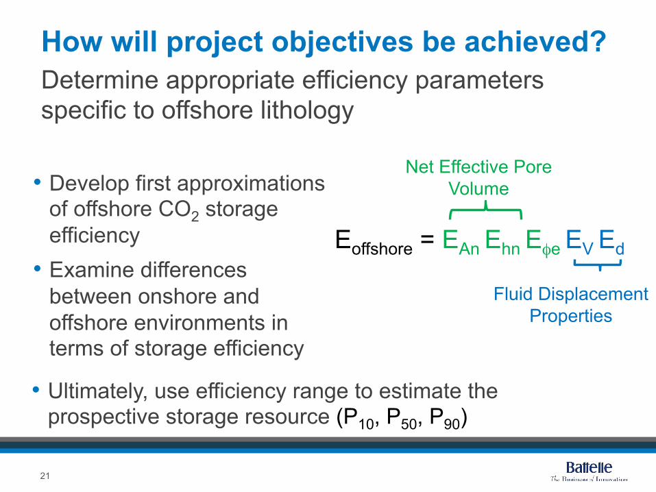
• Develop first approximations of offshore CO2 storage efficiency
• Examine differences between onshore and offshore environments in terms of storage efficiency
Determine appropriate efficiency parameters specific to offshore lithology
Net Effective Pore Volume
Fluid Displacement Properties
Eoffshore = EAn Ehn Eφe EV Ed
21
• Ultimately, use efficiency range to estimate the prospective storage resource (P10, P50, P90)
How will project objectives be achieved? Examine risk factors that may impact storage resource estimates
Source: BOEM, 2015. Source: BOEM, 2015.
Bathymetry
Map shows items like marine protected areas, national marine sanctuaries, hazardous areas, telecommunication cables.
22
How will project objectives be achieved?
• Several workshops will be held
• Objective is to seek input for road mapping, examination of risk and other factors
Engage stakeholders to assist future project planning and implementation
MRCSP Annual Partner’s Meeting, 2015
23
MRCSP partnership members at the East Bend Electricity Generating Station, Kentucky, to observe the geologic storage demonstration
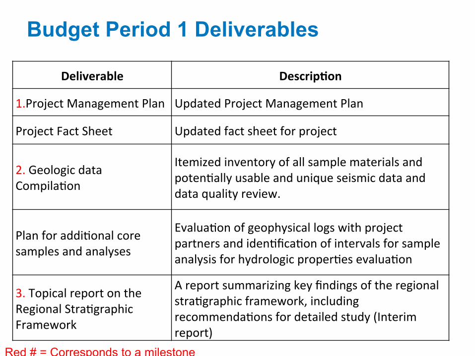
What are the schedule and deliverables? A lot to do within 36 months / 2 Budget Periods!
• Completing the data inventory § Reviewing in-house data (geo surveys)
§ Digitized well logs from 10 wells drilled in Georges Bank – more to do
• Building a database to support carbon storage resource calculations and data integration
• Reviewing seismic data for data quality and selecting and prioritizing lines for additional pre-stack and post-stack processing of data § ~1000 line km for the first batch
Team is actively compiling and prioritizing data
NJ
USGS multibeam bathymetry surface and interpreted 2-D seismic reflection profiles of the Mid-Atlantic Margin
27
What does the future hold?
• Completion of data collection and analysis
• Incorporation into the Prospective CO2 Storage Resource calculations
• Development of clearly-defined criteria for screening potential offshore storage formations
• Uncertainty quantification specific to offshore storage environments and storage resource estimates
• Examining risk factors and hosting stakeholder workshops for road mapping
Stay tuned for budget period 2 NJ
28
Summary • Mid-Atlantic Offshore study area includes three major basins
• The study area is close to numerous CO2 sources
• The project builds on work done under MRCSP and other projects
• Methodologies developed will support CO2 storage assessment in mid-Atlantic U.S. offshore areas
• The project includes an assessment of risk, safety, and deployment factors
• Diverse and highly qualified project team ensures expansion of institutional knowledge
• The study is synergistic with other offshore projects and potential future exploration