Looking after all our water needs Water resource allocation planning series Report no 37 September 2012 Middle Canning River surface water allocation plan September 2012 Middle Canning River surface water allocation plan (below Canning Dam to Kent Street Weir)
Transcript
Looking after all our water needs
Water resource allocationplanning seriesReport no 37September 2012
Department of Water168 St Georges Terrace, Perth, Western Australia
PO Box K822 Perth Western Australia 6842Phone: 08 6364 7600
Fax: 08 6364 7601www.water.wa.gov.au
9071 100 0912
Mid
dle
Ca
nn
ing
Riv
er su
rfac
e w
ate
r allo
ca
tion
pla
n
Sep
tem
be
r 2012
Middle Canning Riversurface water allocation plan(below Canning Dam to Kent Street Weir)
Department of WaterWater resource allocationplanning seriesReport no 37September 2012
Middle Canning Riversurface water allocation plan
(below Canning Dam to Kent Street Weir)
Department of Water 168 St Georges Terrace Perth Western Australia 6000 Telephone +61 8 6364 7600 Facsimile +61 8 6364 7601 National Relay Service 13 36 77 www.water.wa.gov.au
This work is copyright. You may download, display, print and reproduce this material in unaltered form only (retaining this notice) for your personal, non-commercial use or use within your organisation. Apart from any use as permitted under the Copyright Act 1968, all other rights are reserved. Requests and inquiries concerning reproduction and rights should be addressed to the Department of Water.
ISSN 1327-8428 (print) ISSN 1834-2620 (online)
ISBN 978-1-921907-85-2 (print) ISBN 978-1-921907-86-9 (online)
Acknowledgements
The Department of Water acknowledges the middle Canning River surface water project team, project board, and the Swan Avon regional staff for their contribution to this publication.
For more information about this plan, contact:
Swan Avon Region Department of Water7 Ellam StreetVictoria Park Western Australia 6100
Telephone 08 6250 8000Facsimile 08 6250 8050
Disclaimer
This document has been published by the Department of Water. Any representation, statement, opinion or advice expressed or implied in this publication is made in good faith and on the basis that the Department of Water and its employees are not liable for any damage or loss whatsoever which may occur as a result of action taken or not taken, as the case may be in respect of any representation, statement, opinion or advice referred to herein. Professional advice should be obtained before applying the information contained in this document to particular circumstances.
This publication is available at our website <www.water.wa.gov.au> or for those with special needs it can be made available in alternative formats such as audio, large print, or Braille.
Middle Canning River surface water allocation plan
i i i
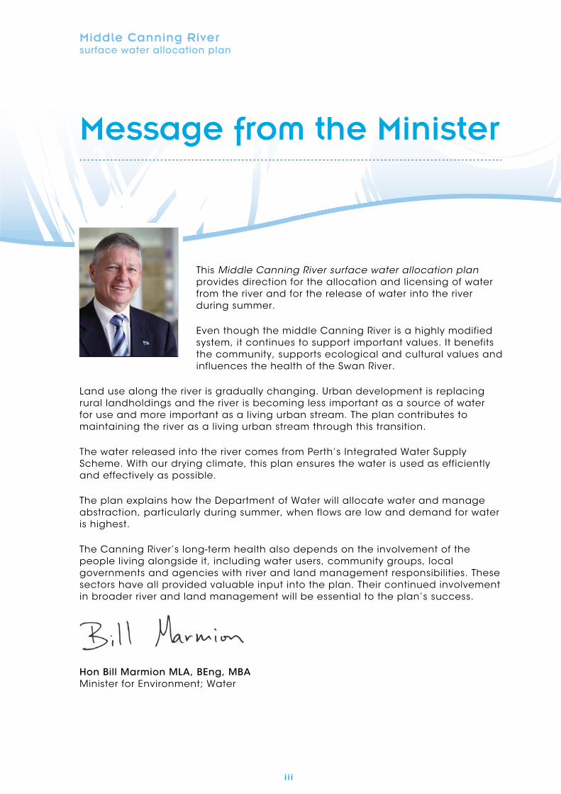
This Middle Canning River surface water allocation plan provides direction for the allocation and licensing of water from the river and for the release of water into the river during summer.
Even though the middle Canning River is a highly modified system, it continues to support important values. It benefits the community, supports ecological and cultural values and influences the health of the Swan River.
Land use along the river is gradually changing. Urban development is replacing rural landholdings and the river is becoming less important as a source of water for use and more important as a living urban stream. The plan contributes to maintaining the river as a living urban stream through this transition.
The water released into the river comes from Perth’s Integrated Water Supply Scheme. With our drying climate, this plan ensures the water is used as efficiently and effectively as possible.
The plan explains how the Department of Water will allocate water and manage abstraction, particularly during summer, when flows are low and demand for water is highest.
The Canning River’s long-term health also depends on the involvement of the people living alongside it, including water users, community groups, local governments and agencies with river and land management responsibilities. These sectors have all provided valuable input into the plan. Their continued involvement in broader river and land management will be essential to the plan’s success.
Hon Bill Marmion MLA, BEng, MBA Minister for Environment; Water
iv
Middle Canning River surface water allocation plan
v
Contents
Message from the Minister iii
Summary vii
1 Plan context and scope 1
1.1 Purpose of the plan 1
1.2 Scope of the plan 1
1.3 Plan area 3
1.4 Plan timeframe 3
1.5 Stakeholder interests 3
2 What the plan will achieve 5
2.1 Objectives 5
2.2 Strategies 5
2.3 Measuring the plan’s success 6
3 Allocation limits 7
3.1 Setting an allocation limit 7
3.2 Components of the allocation limit 7
4 Water allocation and licensing approach 9
4.1 Legislative requirements 9
4.2 Approach to allocating water 10
4.3 Licensing policy 12
5 Managing water releases 15
5.1 Why we release water into the middle Canning River 15
5.2 How and when is water released? 17
5.3 What will happen in low-winter-rainfall years? 18
5.4 Variations to releases 19
6 Monitoring program for the middle Canning River plan area 21
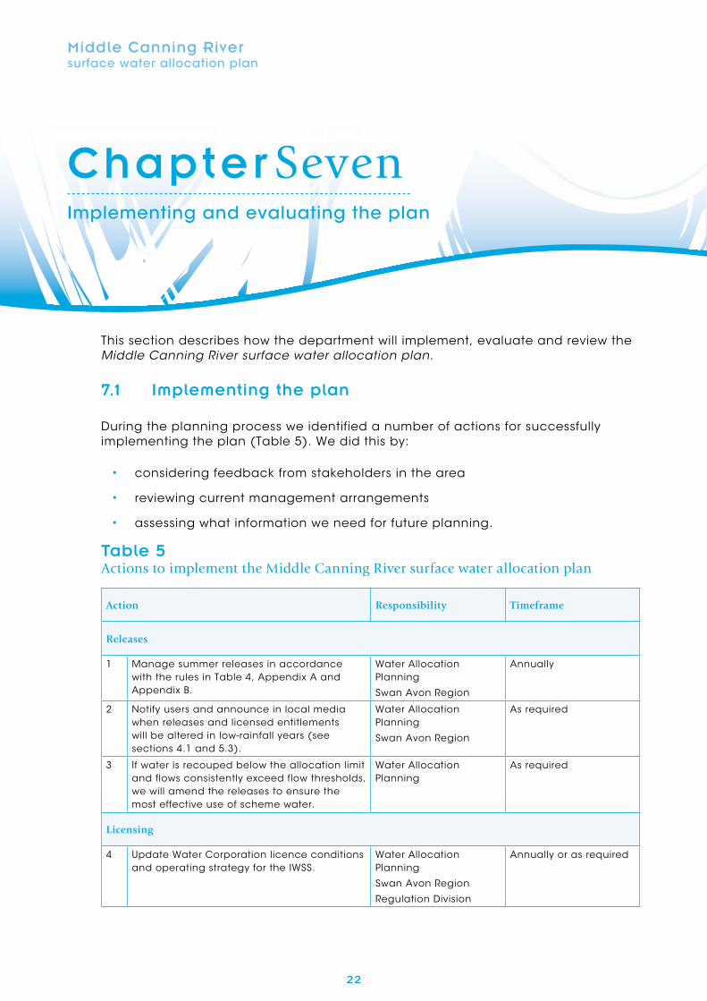
7 Implementing and evaluating the plan 22
7.1 Implementing the plan 22
7.2 Evaluating the plan 24
vi
Contents
Appendices 25
Appendix A Standard release schedule 26
Appendix B Low-rainfall-year release schedule 28
Appendix C Map information and disclaimer 29
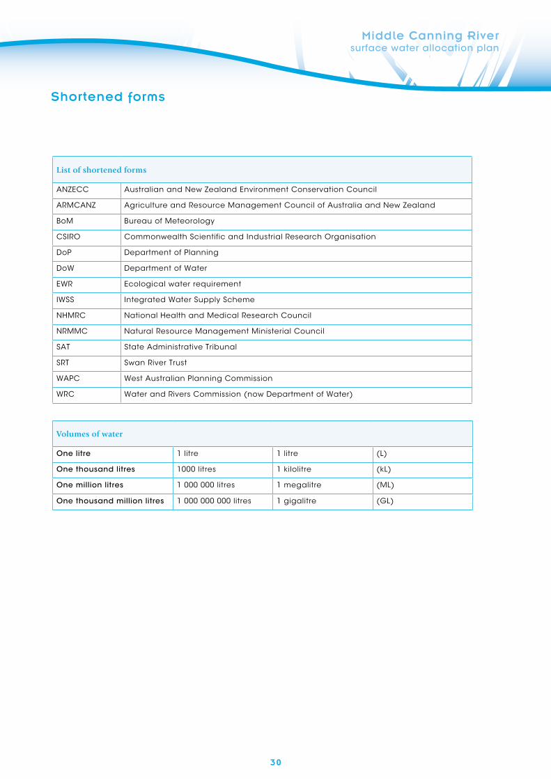
Shortened forms 30
Glossary 31
References 33
Figures
Figure 1 Middle Canning plan area and catchments 2
Figure 2 Location of the six management reaches and release points along the 16 middle Canning River
Tables
Table 1 Allocation limit for the middle Canning River surface water resource 8
Table 2 Licensing policy specific to the middle Canning River plan area 12
Table 3 Statewide policies that apply in the middle Canning River plan area 13
Table 4 Variations to management of the releases 20
Table 5 Actions to implement the Middle Canning River surface water 22 allocation plan
Table 6 Performance indicators against the plan objectives 24
vi i
SummaryMiddle Canning River surface water allocation plan
The Department of Water uses allocation plans to manage how water is taken from surface water and groundwater systems, while meeting the social and cultural values and ecological needs of those systems.
This Middle Canning River surface water allocation plan replaces the Canning River interim allocation policy (WRC 1996). It applies to the section of the middle Canning River from the base of the Canning Dam to the Kent Street Weir in Wilson.
Need for a plan in this area
Since 1940 almost all of the water in the Canning River has been stored to provide water for Perth’s Integrated Water Supply Scheme (IWSS). Because downstream flows were dramatically reduced after damming, some treated scheme water has been released to the middle Canning River each summer. Originally these summer releases were to enable people living alongside the river to access water for economic and domestic purposes. This demand has gradually reduced as the area has urbanised and direct access to public water supply from the IWSS has increased. Summer releases have also contributed to maintaining the river’s ecological, social and cultural values and these needs continue. Though it is a highly modified system, these values are important to the river’s traditional owners, to people living near the river and to visitors.
In this context the plan sets out how we will manage the beneficial use of this high-value resource while maintaining
the middle Canning River as an important urban river environment. Over many years stakeholders have worked with us to update the management arrangements for the middle Canning River.
Water availability
Inflow to the river is from local catchment runoff in winter and from the scheme releases in summer. Winter rainfall is declining across the plan area and there are competing consumptive demands outside the plan area for treated scheme water. The combination of low flows and ongoing abstraction mean that not all needs can be met, especially in dry years. To manage this, we have reduced the allocation limit slightly, and made the scheme releases more efficient. We have set a new allocation limit at 650 000 kL,10 per cent below current use. Water use will be reduced and entitlements recovered as land use alongside the river changes and licensed and riparian use of water from the river is no longer required. The new allocation limit will prevent reallocation of this water and thus gradually reduce impacts on both remaining water users and non-consumptive values.
Water for new developments will only be available through:
• increased water use efficiency
• accessing water from scheme supply
• alternative water sources, where available.
Middle Canning River surface water allocation plan
vi i i
Summary continues
Management approach
The plan sets out the department’s approach to managing surface water resources in the plan area. It describes how we will:
• release scheme water into the river during the summer months, including triggers for turning releases on and off
• respond to dry years by reducing releases and abstraction
• manage the abstraction of water, focusing on a gradual recouping of surface water entitlements as land uses change.
Summer releases are only one factor contributing to river health. The plan does not include strategies for addressing drainage, stormwater, sediment management and other land planning issues. We will continue to work with the responsible agencies to directly manage these issues.
Updating the plan using the public submissions
We received 16 submissions on the Lower Canning River surface water allocation plan: for public comment (DoW 2010c). The plan has been renamed the Middle Canning River surface water allocation plan. Our response to these submissions and an explanation of how we used the comments to update the plan is described in the statement of response (DoW 2012).
1
Chapter OnePlan context and scope
Middle Canning River surface water allocation plan
The middle Canning River’s surface water resources support important social, cultural and ecological values and its abstraction provides economic benefits to landholders adjacent to the river.
Flows in the Canning River are highly modified as a result of dams and pumpback stations associated with Perth’s Integrated Water Supply Scheme (IWSS). The infrastructure is managed by the Water Corporation and includes three public water supply dams (Canning, Churchman Brook and Victoria) and two pumpback stations (Araluen and Bickley). After the dams were built, several release points were constructed along the river to supply scheme water (during summer) to users living alongside the river and to meet the river’s social and ecological needs of the river.
1.1 Purpose of the plan
Declining rainfall has resulted in lower natural flow levels, which in turn has affected the river’s ecological values and the ability of water users to abstract. The lower rainfall has also led to increased pressure on the IWSS. This plan reflects these changes. We have updated the allocation limit, our licensing approach and how releases will be managed to be more efficient while still supplying water to users and maintaining the river’s key ecological functions.
Land use adjacent to the river has changed significantly since the interim plan was developed in 1996. There has been a shift from agricultural towards rural residential and urban uses. With these changes, the need to abstract water from the river has declined, and the river will be managed more as a living urban stream.
1.2 Scope of the plan
The department has developed this plan and set allocation limits using the best-available information. We have also considered questions posed during the community consultation process and input from our advisory group, the Middle Canning River Stakeholder Group.
The plan shows:
• the plan area
• the objectives for water allocation and ongoing water resource management
• the allocation limit
• our approach to allocation and licensing including:
- licensing rules
- how water will be allocated in low-rainfall years
- the strategy to recover over-allocation
2
1 Plan context and scope
Figure 1Middle Canning plan a rea and catc hments Middle Canning River surface water allocation plan
!(
!(
!(
!(
!(
Brookton Hwy
South W
estern Hw
y
Albany Hwy
Tonkin Hw
y
Kwin
ana
Fwy
Roe H
wy
Great E
aster
n Hwy
Cannin
g Hw
y
Perth
Armadale
Kalamunda
Mundaring
Roleystone
±0 4
Kilometres
LegendMiddle Canning catchment
Wungong River
Bickley Brook
Stoney Brook
Yule Brook
Stinton Creek
Ellis Brook
!( Localities
Main roads
Canning River
Main tributaries
Catchments of the Middle Canning
!(
!(
Perth
Mandurah
0 4020
Kilometres
DoW reference: 33026610Report name and year: Middle Canning River Surface
Water Allocation Plan, 2012
Government of Western AustraliaDepartment of WaterGovernment of Western AustraliaDepartment of Water
Map reference: 33026610
3
1
Middle Canning River surface water allocation plan
Plan context and scope
• how water will be released
• how we will implement and evaluate the plan including:
- a monitoring program to measure streamflow and review critical low-flow thresholds.
The plan does not:
• address management of the Kent Street Weir
• cover drainage, stormwater, sediment management and other land planning issues.
Even though this plan cannot address the important land planning issues outlined above, we will continue to work with the agencies responsible for them because they impact on the effectiveness of the allocation and water release arrangements.
1.3 Plan area
Location
This plan applies to the middle Canning River, which is located in the Perth metropolitan area’s south-east corridor, as shown in Figure 1. It includes the freshwater reach of the Canning River from the base of the Canning Dam to the Kent Street Weir in Wilson.
Proclamation
The Canning River channel was proclaimed under the Rights in Water Irrigation Act 1914 (WA) in January 1914. This means that water users require a water licence to lawfully abstract surface
water under Section 5C of the Act in this area, unless exempted under the Act.
1.4 Plan timeframe
The Middle Canning River surface water allocation plan will remain in effect until 2016 after which it will be reviewed and may be replaced. It may be amended or revoked by the Minister for Water or replaced sooner if it is identified as necessary through the periodic evaluation process.
1.5 Stakeholder interests
Collaboration on the management of the middle Canning River has a long history. Our consultation for the allocation plan drew on work started through the Canning River interim allocation policy (WRC 1996), Caring for the Canning: a plan to revitalise the Canning, Southern and Wungong rivers (SRT 2002) and the department’s ecological water requirements study (Radin et al. 2010).
Valuable advice on the allocation plan has come from community groups, the Water Corporation, local government, other state government agencies and licensees. The Canning River Stakeholder Group, which represents these interests, provided a focus for consultation during the plan’s development.
The main aspects for consultation were:
• the department’s approach to summer releases
• the department’s approach to managing licences to take water
• availability of water for use
4
1
Middle Canning River surface water allocation plan
• unauthorised taking of water
• broad catchment management issues outside the scope of this plan including:
- river restoration and revegetation
- foreshore and reserve management
- water quality
- channel modification, erosion and sedimentation.
We also consulted with licensees and riparian users during the 2010–11 dry season on the impact of reduced release volumes and ways they could improve water use efficiency.
We considered all consultation in preparing this plan, as well as submissions received during the public comment period. Our responses to all submissions are documented in the Middle Canning River surface water allocation plan – Statement of response (DoW 2012).
5
Middle Canning River surface water allocation plan
Chapter TwoWhat the plan will achieve
This section describes our objectives for the allocation of surface water in the middle Canning River plan area. Most of the Canning River’s water is stored for public water supply in the dams on the upper part of the river. The plan’s objectives for the river recognise that the scheme water released into it is valuable and must be used effectively and efficiently, and that existing licensees are relying on the river for their livelihoods. The objectives also recognise that maintaining the river’s ecological function is important to the local community for social and cultural reasons.
2.1 Objectives
The water resource objectives of this plan are:
R1 To maintain the river’s capacity to supply water for use as needs change
R2 To maintain sufficient flow regimes (summer and winter) in a changing climate to minimise risks to the riverine environment including:
- maintaining summer baseflows
- maintaining oxygen levels and pool connectivity
- provision of occasional pulse flows to meet native fish requirements over the summer months.
The management objectives of this plan are:
M1 To recover licensed entitlements to within the allocation limit
M2 To improve water use efficiency
M3 To reduce abstraction to allow the releases to be minimised following low-rainfall winters
M4 To reduce unauthorised water use.
2.2 Strategies
This plan provides the management approach for water releases and for allocation and licensing, and informs the department’s advice on land use planning processes.
To meet the objectives of this plan we will:
• manage to the allocation limits in Table 1
• deliver the releases through the actions in Section 5.4
• follow the approach for allocating and licensing water set out in Section 4
• license water abstraction according to the licensing rules in Section 4.3
• monitor the resources using the program explained in Section 6
• carry out the actions for the plan outlined in Section 7.1.
6
2 What the plan will achieve
Middle Canning River surface water allocation plan
2.3 Measuring the plan’s success
The department will regularly evaluate the plan to see if the objectives are being met. The results will be published in an evaluation statement. See Chapter 7 and Section 7.2 for more information on how we will monitor and evaluate the plan’s performance.
7
Middle Canning River surface water allocation plan
Chapter ThreeAllocation limits
An allocation limit is the total volume of water set aside for annual take from a resource. This includes water available for licensing and water for uses exempt from licensing such as small-scale riparian use. This plan sets the allocation limit for the middle Canning River surface water resource. The allocation limit takes into account both the inflows from the catchment, and the summer releases of scheme water.
3.1 Setting an allocation limit
With reduced rainfall and declining streamflow, the river cannot sustain the current levels of abstraction. Even with supplementation, there are impacts on the river’s cultural and social values and the critical ecological values that sustain them. To protect these values while supporting the remaining beneficial uses of the resource, the new allocation limit is set at 10 per cent below current use volumes. This will prevent growth in use, enable recouping, drive efficiency and gradually bring the volume of licensed use closer to sustainable abstraction levels. We will also reduce unauthorised use within the life of this plan.
The allocation limit has been set at this level because it:
• is consistent with the declines we have seen in licensed use, largely due to land use changes in recent years
• supports the staged recovery of the water resource to sustainable levels of use without affecting current authorised use.
This resource is now managed as over-allocated and no additional water is available for abstraction.
As we track the implementation of this plan’s strategies and actions, we will also evaluate the allocation limit to ensure it is supporting the plan’s objectives.
3.2 Components of the allocation limit
For administrative purposes, the allocation limit has two components:
• licensable components (including general licensing and licensed public water supply)
• unlicensed components (including water for small-scale riparian use).
The allocation limit, its components, and the status of water availability for licensing (at 10 August 2012) are shown in Table 1.
8
3 Water allocation limits
Middle Canning River surface water allocation plan
Table 1Allocation limit for the middle Canning River surface water resource
Allocation limit kL/yr
Component for unlicensed use kL/yr
Component for general licensing kL/yr
Resource status for licensing
650 000 42 000 608 000 No new water available (over-allocated)
9
Middle Canning River surface water allocation plan
Chapter FourWater allocation and licensing approach
Water licences are the regulatory instrument the department uses under the Rights in Water and Irrigation Act 1914 to manage the individual abstraction of surface water.
This allocation plan includes policies and rules to address water allocation and licensing issues in the plan area.
4.1 Legislative requirements
Water licences
The Rights in Water and Irrigation Act 1914 establishes the legislative framework for managing and allocating water in Western Australia.
Water users in the middle Canning River plan area generally require a water licence to lawfully take surface water under Section 5C of the Act. When assessing a water licence application the department considers the allocation plan as well as Clause 7 (2) of Schedule 1 of the Act.
The department, in granting a licence, may apply terms, conditions and restrictions to licences under Clause 15 of Schedule 1 of the Act. For large licences this may include an operating strategy.
The department’s requirements for altering any licence condition are specified under Clause 24 (1) of Schedule 1 of the Act. The rights of licensees are covered under Clause 26.
A permit is required to interfere with the bed and banks of watercourses. This includes installing pipes, pumps or constructing dams, under clauses 11, 17 and 21 of the Act,
Riparian rights
Riparian rights are detailed in Part III, Division 1B, sections 9 and 20 of the Rights in Water and Irrigation Act 1914. A riparian right grants a landholder whose property borders a watercourse the right to abstract surface water without a licence for domestic use, watering stock (other than under intensive conditions) or non-commercial irrigation (gardens/orchards from which no produce is sold). This right does not guarantee that water will be available.
Exemptions
The taking of surface water from the resource is exempt from licensing where it is used solely for fire fighting purposes.
10
4 Water allocation and licensing approach
Middle Canning River surface water allocation plan
4.2 Approach to allocating water
The department’s approach to allocating water is designed to maximise the beneficial use of this high-value resource by providing some water for use and some for key environmental flows. We use the licensing process to share the available water, up to the allocation limit.
The approach is influenced by the fact that in this plan area, there is insufficient water to meet all needs, especially in dry years. The resource will now be managed as over-allocated.
Allocating water in low-rainfall years
During low-winter-rainfall periods (as defined in Section 5.3) the department encourages existing users to reduce their abstraction and supplement use with an alternative supply such as rainwater tanks, groundwater or scheme water.
Following low-rainfall winters, licensed and riparian users will be asked to reduce their summer water abstraction by 50 per cent. If water is available from other sources (e.g. scheme water), this water should be used in preference to taking water from the river. We are confident that water users will take the necessary measures to reduce their use. However, we may formally seek to reduce licence volumes by changing licence conditions if voluntary reductions are not successful.
In addition, because the middle Canning River’s flow during summer is predominantly from scheme water, those using water for non-commercial purposes should observe any restrictions for scheme water users. It is a condition
of some surface water licences that water for non-commercial crops (i.e. lawns and gardens) is not used between the hours of 9am and 6pm.
Notification
If a low-rainfall winter triggers reductions in releases and use, we will notify water users by letter and make announcements in the local media at the end of October.
Recovery strategy
Not all licensed entitlements in the middle Canning River plan area are fully utilised. As the current licensed volume is above the new allocation limit, the department will recoup unused water entitlements in the plan area.
We will recoup unused licensed entitlements (or unused portions of them) in accordance with Statewide policy no. 11 – Management of unused licensed water entitlements (WRC 2003). The opportunity to recoup will be identified:
• at licence renewal
• if a licence is amended (traded/transferred)
• during routine compliance surveys.
As land uses change we will take the opportunity to recoup water.
Because the resource is over-allocated we will not reallocate recouped water entitlements. We may review the allocation limit, consistent with the plan’s objectives.
1 1
4Water allocation and licensing approach
Middle Canning River surface water allocation plan
Reducing riparian use of surface water
Approximately 30 properties historically had riparian rights along the middle Canning River. As land uses changed and became more urbanised (with access to scheme water), the number of properties with this right has decreased.
Compliance and enforcement
Unauthorised use is subject to the enforcement provisions of the Rights in Water and Irrigation Act 1914, including a $10 000 fine and an additional $1000 for each day of continued non-compliance. Unauthorised use may include:
• licensed users exceeding their licensed entitlement, or any terms, conditions or restrictions placed on their licence
• using water taken under a riparian right for uses other than those defined in sections 9 and 20 of the Act.
Auditing licensed use
The department may audit licence compliance to ensure that water abstraction and use is in accordance with licence volumes and conditions. We also review monitoring and metering data to assess whether any local impacts are occurring and to ensure that the licence conditions are appropriate for that particular circumstance. Where non-compliance or unauthorised use is identified we will undertake the appropriate enforcement measures.
Water use efficiency
To meet the plan’s objectives we encourage all licensees and riparian users to implement water efficiency measures.
We will work with public water suppliers, local government authorities, government agencies and land developers to ensure that water use in urban areas is in accordance with Operational policy no 1.2 – Policy on water conservation and efficiency plans (DoW 2009c) as well as their licence conditions and any other operational strategies in place.
Sprinkler restrictions
As discussed in Section 4.2, because the middle Canning River’s water during summer is essentially scheme water, all non-commercial water users should observe the current sprinkler restrictions for scheme water users.
Alternative and fit-for-purpose water sources
Where possible, users should consider alternative supplies such as scheme water (where available), recycled wastewater, drainage water and rainwater to meet their water requirements.
12
4 Water allocation and licensing approach
Middle Canning River surface water allocation plan
4.3 Licensing policy
Local licensing rules for the middle Canning River plan area
These local policies provide additional guidance to manage water-related issues specific to the middle Canning River plan area. They apply because either the local issues are not addressed in statewide policy or an alternative approach is needed to better manage the local issue. Where a local policy differs from a statewide policy, the local policy in this allocation plan is applied.
Table 2Licensing policy specific to the middle Canning River plan area
Policy group Policy details
1 Water licensing and use
1.1 Water level and flow criteria
1.1.1 Where abstraction is likely to have a detrimental impact during low-flow periods on downstream water users, flows, water levels or water quality, the department may specify the following as licence conditions:
• a maximum daily abstraction rate
• a period when pumping is permitted
• a minimum water level above which abstraction is permitted
• additional monitoring and measurement
• installation of a staff gauge to monitor water levels.
1.2 Metering and monitoring
1.2.1 Licensees with a larger entitlement (greater than or equal to 20 000 kL/yr) are required to install and maintain a department-approved meter within three years of the issue of this plan.
2 Trading (water entitlement transactions)
2.1 Trading and transfers
2.1.1 Water which has not been used for the previous three years is not normally eligible to be traded or transferred.
2.1.2 Trades will be assessed under Clause 7(2) of Schedule 1 to the Rights in Water and Irrigation Act 1914 and it is unlikely that unused entitlements will be traded in line with the objectives of the plan.
2.1.3. Any change in the location of drawpoints in the Trust Development Control Area (as defined under the Swan and Canning Rivers Management Act 2006) will require approval from the Swan River Trust.
3 Recovery of over-allocated resources
3.1 Recovery 3.1.1 Recouped water will not be reallocated
13
4Water allocation and licensing approach
Middle Canning River surface water allocation plan
Statewide licensing policies
The department develops policies that apply to all water resources across the state, including the middle Canning River plan area. Table 3 outlines the main strategic and operational policies that apply to plan area. An up-to-date list of the policies is available on our website: <www.water.wa.gov.au> Doing business with us > Water licensing>.
Table 3Statewide policies that apply in the middle Canning River plan area
Policy Description
Operational policy no. 5.08 – Use of operating strategies in the water licensing process (DoW 2010a)
Guidance on when an operating strategy is required and what it should contain, including:
• the water licence circumstances likely to require an operating strategy
• how operating strategies form part of the conditions of a water licence
• how the licensee should develop an operating strategy
• the licensee’s responsibilities in complying with an operating strategy.
Operational policy no. 5.13 – Water entitlement transactions for Western Australia (DoW 2010b)
The rules for a trade, transfer or lease of all or part of a licensed water entitlement. Of particular note:
• new landholders must apply to transfer water entitlements within 30 days of the land sale
• trading will only be possible where it can be demonstrated that the new drawpoint will result in equivalent or better environmental outcomes and improved water efficiencies.
Statewide policy no. 11 – Management of unused licensed water entitlements (DoW 2003)
Whole or portions of licensed entitlements may be recouped by the department if:
• it is proved the entitlements are consistently unused
• extenuating circumstances cannot be provided.
Operational policy no. 1.2 – Policy on water conservation and efficiency plans: achieving water-use efficiency gains through water licensing (DoW 2009c)
Under this policy the department may require licensees to implement water conservation and efficiency plans. We may require users, as part of the licensing process, to identify opportunities for using fit-for-purpose lower quality water (e.g. drainage water, stormwater and recycled water) in such plans.
Strategic policy no. 5.03 – Metering the taking of water (DoW 2009a)
Guidelines for water meter installation (DoW 2009b)
Rights in Water and Irrigation (Approved Meters) Order 2009 factsheet (DoW 2009e)
Outlines the department’s position on metering the taking of water in Western Australia. The policy also details the circumstances in which we may impose metering conditions on individual licences (except under 1.1.1).
Guidance on how the department provides water for environmental flows and the passage of aquatic life in surface water and groundwater resources across the state.
Middle Canning River surface water allocation plan
Additional information
Drinking of surface water
The department does not recommend the middle Canning River’s water for drinking. If surface water is used for private drinking water supplies, we recommend that it be filtered, treated and tested according to public health advice from the Department of Health. Also see our water quality protection notes, the Australian drinking water guidelines (NHMRC 2004) and the Australian fresh and marine water quality guidelines (ANZECC & ARMCANZ 2000) for more information.
15
Middle Canning River surface water allocation plan
Chapter fiveManaging water releases
5.1 Why we release water into the middle Canning River
The middle Canning River is a highly regulated river with modified values, but it remains important as a living urban stream. The river’s ecology has changed in response to the modified flow regime resulting from damming, summer releases, declining rainfall and use. We have designed a new release regime to efficiently and effectively deliver water to maintain the modified ecological functions, benefit licensees, and provide for cultural and social values.
The hydrological record before the dam and pumpback stations were built on the Canning indicates a strong variation in seasonal spring/summer and winter flow regimes. The winter months were dominated by high channel-forming flows that inundated the lower floodplain during flood events. During the summer months, although flows would reduce, the river did not cease to flow.
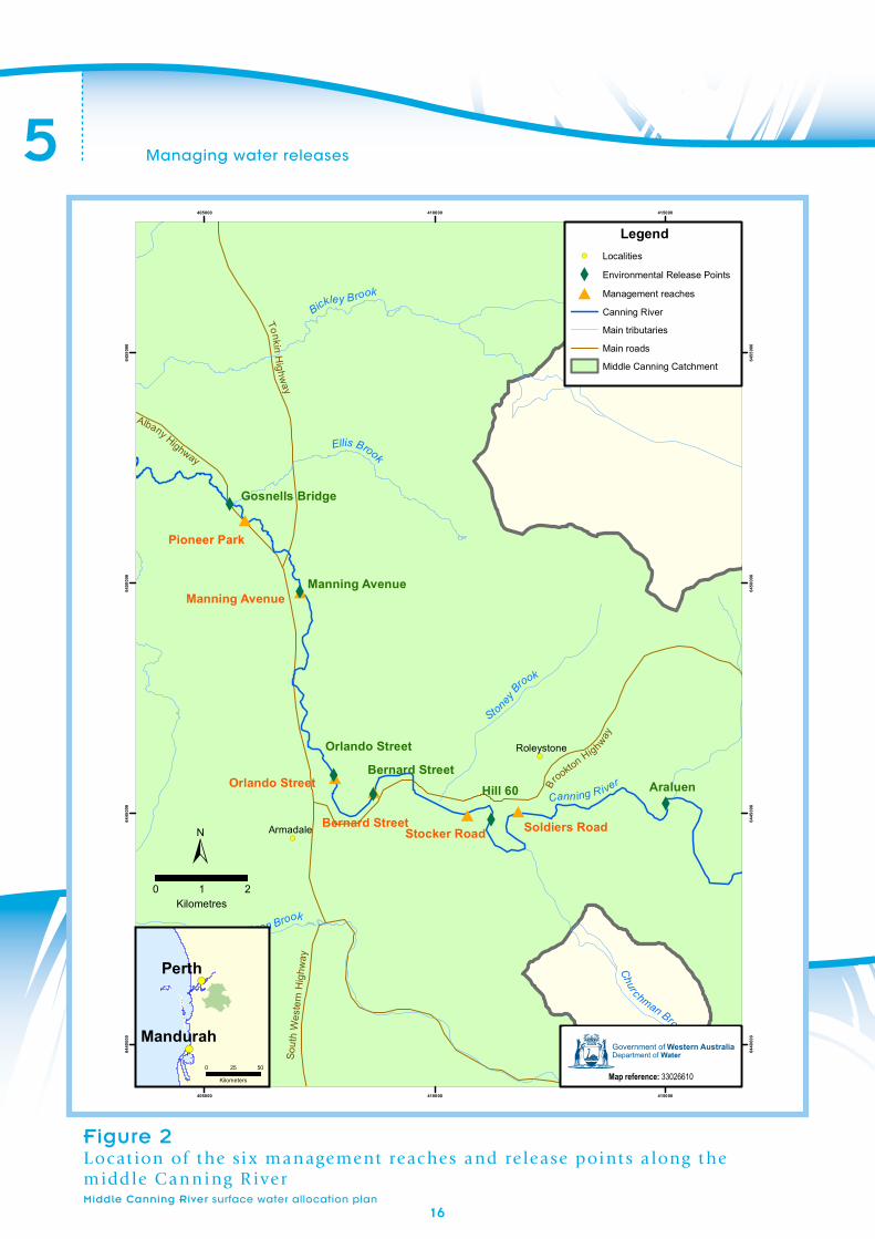
In most years more than 80 per cent of annual flow in the middle Canning River occurs between June and October. During the drier months between November and May, streamflows are supplemented by the release of treated scheme water through six release points (Figure 2).These release points have been operating for decades and were originally designed to compensate horticultural water users for the loss of flow after the Canning and Wungong dams were built.
While post-dam natural flow is still seasonal, both summer and winter flows have declined in line with declining rainfall.
The Noongar name for the Canning River is Dyarlgarro, meaning place of abundance. The river is rich in Noongar culture and history. Many significant and sacred sites are embedded within its banks and its entire channel is classified on the Department of Indigenous Affairs Register of Aboriginal Sites.
16
Managing water releases5
#
##
#
#
#X
X
XX
X
X
!(
!(
Ellis Brook
Stoney B
rook
Canning River
Churchman Brook
Bickley Brook
Neerigen Brook
Albany Highway
Brookto
n HighwayTonkin H
ighway
Sout
h W
este
rn H
ighw
ay
Armadale
Roleystone
405000
405000
410000
410000
415000
415000
6440
000
6440
000
6445
000
6445
000
6450
000
6450
000
6455
000
6455
000
!(
!(Perth
MandurahDoW reference: 33026610Report name and year:
Legend!( Localities
X Environmental Release Points
# Management reaches
Canning River
Main tributaries
Main roads
Middle Canning Catchment
±0 21
Kilometres
0 5025
Kilometers
Gosnells Bridge
Manning Avenue
Orlando Street
Bernard StreetHill 60 Araluen
Pioneer Park
Manning Avenue
Orlando Street
Bernard StreetStocker Road Soldiers Road
Government of Western AustraliaDepartment of Water
Middle Canning River SurfaceWater Allocation Plan, 2012
Figure 2L ocat ion of t he si x management reac hes and re lease point s a long t he middle Canning R iver Middle Canning River surface water allocation plan
Government of Western AustraliaDepartment of Water
Map reference: 33026610
1717
5
Middle Canning River surface water allocation plan
Managing water releases
5.2 How and when is water released?
The release arrangements
In summer scheme water is released from six points along the middle Canning River. These releases maintain key ecological functions, benefit licensees, and provide for the cultural and social values of this living urban stream. The release schedule is part of the Water Corporation’s operating strategy for the IWSS.
Studies to determine the ecological water requirements (EWRs) to maintain the current ecological values of this highly modified river informed this allocation plan. For the details and findings of these studies, see the supporting document, Ecological water requirements of the lower Canning River (Radin et al. 2010). The document also describes the water release program that was trialled in summer 2007 by the Department of Water and Water Corporation (the release program is referred to as the environmental flow provision).
The river’s ecological, social and cultural values are described in Caring for the Canning: a plan to revitalise the Canning, Southern and Wungong rivers (SRT 2002), and have been confirmed through consultation with the Canning River Stakeholder Group (see Section 1.5).
Using the trial results, the EWR document and information from the other studies, we designed the current release schedule. Details of the release schedule are provided in Appendix A.
Summer releases
The objective of the summer releases is to ensure the river does not stop flowing between the Araluen pumpback and the Kent Street Weir. The release maintains flow connectivity and pool depth, submerging riffles and preventing anoxic conditions.
These releases comprise the majority of the river’s summer baseflow. The department monitors the mean daily discharge at Seaforth gauging station to ensure an adequate baseflow is being maintained.
Additionally, three pulse flows each of five days duration will be provided in summer, either naturally or through additional releases, if winter rainfall has been average or above (see Appendix A). The purpose is to inundate in-stream obstacles that act as a barrier to fish migration. This is particularly relevant for freshwater cobbler, which migrate and spawn during the summer months.
An additional release (2.5 ML/day) will be made for 10 days each February from the base of the Canning Dam. This release will provide water higher up in the system (above the Araluen pumpback). This stretch of the river has high ecological values.
Winter flows
During the winter months, river flow comes from catchment rainfall/runoff – not from releases of scheme water. Releasing scheme water into the river during winter would not be an effective use of that water. The volume of water delivered through summer releases is very low relative to the flows generated by catchment rainfall/runoff in the winter.
1818
5 Managing water releases
Middle Canning River surface water allocation plan
Future climate and maintaining releases
The releases for the middle Canning River established in this plan are based on the rainfall regime experienced since 1975. The current summer releases factor in a ‘25 per cent loss’ rule, which takes into account water that is abstracted, and the loss of water through evaporation and infiltration.
The CSIRO has investigated future climate scenarios and their effects on streamflows in south-west Western Australia (CSIRO 2009). Under a ‘mid-range’ climate future for the region, the CSIRO study predicted that flows at Seaforth gauging station would be reduced by 20 per cent during winter and 25 per cent during summer. The releases may need to be altered in the future if evaporation rates increase as a result of climate change or if daily abstraction declines or patterns change.
Reduced winter rainfall will mean a greater number of years with low-rainfall conditions (see Section 5.3) and may mean fewer days of bankfull flows during winter.
Reduced summer rainfall may reduce the number of natural pulse flows for fish, resulting in a greater reliance on the specified three pulse flows each summer being provided artificially via releases.
Quality of releases
The water released from the six release points is chlorinated scheme water. Chlorine breaks down rapidly with aeration and exposure to sunlight. Chlorine in the released water dissipates rapidly, so that 500 m
downstream of the release points, chlorine concentrations are within acceptable ANZECC & ARMCANZ (2000) levels for freshwater systems.
The middle Canning River has been substantially affected by sedimentation (as a result of catchment clearance and changing land uses). It is not possible to release enough water through the release structures to move built-up sediment. The releases do not address sedimentation. Reducing sedimentation would require changes to land management in the catchment.
5.3 What will happen in low-winter-rainfall years?
The release points provide flows in the middle Canning River during the summer months. These scheme releases come from the IWSS, which relies on winter (May to October) recharge to groundwater and dams.
When winter rainfall is low, there is less recharge and consequently less water for use in the IWSS and for release into rivers downstream of water supply dams. To manage these periods, the department has developed a low-rainfall response (Table 4) for years when a serious rainfall deficiency1 may lead to reduced water availability from the IWSS. The low-rainfall trigger is based on the lowest 10 per cent of winter rainfall received for the period 1975 to 2008. For this period, winter rainfall (defined as 1 May to 30 September) recorded at Bickley (Bureau of Meteorology station no. 9240) in the lowest 10 per cent of years was below 675 mm.
1 The Bureau of Meteorology defines a serious rainfall deficiency as being rainfall that is equal to or
less than rainfall in the lowest 10 per cent of years. The period used is 1975 to 2008.
1919
5Managing water releases
Middle Canning River surface water allocation plan
Should low-rainfall conditions occur two years in succession, summer ecosystem condition monitoring will be triggered, as well as a review of the low-rainfall response in this plan.
Releases in low and standard winter-rainfall years
If rainfall during the winter months (1 May to 30 September) is below 675 mm, the low-rainfall release schedule will be adopted. If winter rainfall is 675 mm or greater, the standard release schedule will apply.
Under the low-rainfall release schedule, the total releases will equate to around 75 per cent of the standard release schedule. No fish-passage pulse releases will occur (see Appendix B). The low-rainfall release schedule is designed to maintain pool connectivity and water quality.
The standard release schedule has been designed to meet the requirements of surface water users as well as the environmental objectives (see Section 2). In low-rainfall years, releases will be reduced so that water for IWSS customers is prioritised. However, to meet the objectives of the low-rainfall release schedule licensed and riparian users will also need to reduce their abstraction from the river by 50 per cent (see sections 2 and 4).
Notification
If reductions in releases and licensed entitlements are required due to a low-rainfall winter, at the end of October the department will:
• notify licensed and riparian users by letter
• notify other stakeholder groups
• make announcements in the local media.
We will also notify key stakeholder groups when releases are turned on/off or any changes are made (e.g. a fish pulse).
Appendix B outlines the low-rainfall-year release schedule.
5.4 Variations to releases
In certain circumstances we will vary the management of the releases and our response to certain events; for example, changes to water quality (Table 4). Releases may also be varied from time to time to meet operational and other requirements. Appendix A outlines the standard release schedule and Appendix B outlines the low-rainfall year-release schedule.
2020
5 Managing water releases
Middle Canning River surface water allocation plan
Table 4Variations to management of the releases
Trigger Response
Rainfall
Low-rainfall year: rainfall recorded at Bickley during the winter period (1 May to 30 September) is below 675 mm (the lowest 10% of historic winter rainfall).
Apply the low-rainfall release schedule. Volumes are set to around 75% of the standard release schedule (see Appendix B).
Cease fish-passage flows.
Announce reduction in volume of abstraction (50% of licensed entitlement) for all licensed and riparian users downstream of the Canning Dam (see sections 5.3 and 4.1).
Two successive low-rainfall release years.
Implement low-rainfall release schedule for a second year but undertake fish monitoring in the second summer and review the effectiveness of the low-rainfall response in maintaining ecosystem health.
Flows
Standard release year: during the summer months, baseflow falls below 0.021 m3/sec for five consecutive days or more at Seaforth gauging station.
Low-rainfall year: baseflow falls below 0.01 m3/sec for five consecutive days or more.
Survey of water users to determine where over-abstraction is occurring and initiate compliance action.
Water quality
Standard and low-rainfall release years: during the summer months water quality (total nitrogen, total phosphorus, dissolved oxygen and pH) falls below baseline levels (see Table 6) but flows remain above thresholds (above).
Present measurement data to Swan River Trust and local government for their action as issue is unlikely to be a result of low flows.
Water quality decline occurs at the same time as flow declines.
Survey of water users to determine where over-abstraction is occurring and initiate compliance action.
Native fish (as indicators of ecosystem condition, see Section 6)
Native fish species are absent in triennial sampling (see Table 6).
Discontinue fish pulse-flows.
21
Middle Canning River surface water allocation plan
Chapter SixMonitoring program for the middle Canning River plan area
The plan’s monitoring program sets out how the department will monitor water resources in the plan area to support plan evaluation and knowledge of the water resource over time.
The monitoring program has been designed to measure the plan’s success. To check how the river is tracking, we assess the monitoring information we collect, as well as that of water users. This information is reported in the plan’s evaluation statement.
Assessment of the middle Canning River will involve two components: management monitoring and condition monitoring. Management monitoring will focus on the plan’s implementation. It will include monitoring of:
• the timing and volumes discharged from the six release points
• mean daily flow rates and water levels at Seaforth gauging station (AWRC ref. no. 616027 – water level and flow data is available on the river-level monitoring page of our website <www.water.wa.gov.au>)
• the annual volume of water entitlements recouped
• winter rainfall.
Water quality is monitored for the Swan River Trust, including:
• total nitrogen (≤ 1.2 mg/L)
• total phosphorus (≤ 0.065 mg/L)
• pH (between 5.0 and 8.0).
Condition monitoring will focus on ecological parameters and assess:
• key water quality and flow parameters
- measured while releases are occurring at representative sites along the river
- using water quality monitoring undertaken by the Swan River Trust at Seaforth gauging station
• the presence of freshwater fish as an indicator of overall ecosystem health:
- measured every three years while releases are occurring at representative sites along the river
- monitored in the second summer if two successive low-rainfall release years occur.
Middle Canning River surface water allocation plan
This section describes how the department will implement, evaluate and review the Middle Canning River surface water allocation plan.
7.1 Implementing the plan
During the planning process we identified a number of actions for successfully implementing the plan (Table 5). We did this by:
• considering feedback from stakeholders in the area
• reviewing current management arrangements
• assessing what information we need for future planning.
Table 5Actions to implement the Middle Canning River surface water allocation plan
Action Responsibility Timeframe
Releases
1 Manage summer releases in accordance with the rules in Table 4, Appendix A and Appendix B.
Water Allocation Planning
Swan Avon Region
Annually
2 Notify users and announce in local media when releases and licensed entitlements will be altered in low-rainfall years (see sections 4.1 and 5.3).
Water Allocation Planning
Swan Avon Region
As required
3 If water is recouped below the allocation limit and flows consistently exceed flow thresholds, we will amend the releases to ensure the most effective use of scheme water.
Water Allocation Planning
As required
Licensing
4 Update Water Corporation licence conditions and operating strategy for the IWSS.
Water Allocation Planning
Swan Avon Region
Regulation Division
Annually or as required
7Implementing and evaluating the plan
Middle Canning River surface water allocation plan
23
Action Responsibility Timeframe
5 All licensees with entitlements greater than or equal to 20 000 kL/yr have a department-approved flow meter installed within three years of the plan’s release.
Swan Avon Region By 2015
6 Conduct property surveys. Swan Avon Region Ongoing
7 Undertake an audit on riparian use. Identify unauthorised riparian use and investigate options for managing.
Swan Avon Region
Water Allocation Planning
By 2016
Recovery strategy – over-allocated resources
8 Review the allocation limit when:
• water is recouped so that total entitlements are below the licensable component of the allocation limit
• water is recouped so that total entitlements fall to within 5% of the allocation limit.
Swan Avon Region
Water Allocation Planning
As required
Water use efficiency
8 Consider opportunities to use fit-for-purpose water to replace the use of scheme water for releases.
Local government, community groups, Water Corporation and Department of Water
Ongoing
Communication and evaluation statement
9 Produce and publish an evaluation statement on the plan and its implementation.
Swan Avon Region
Water Allocation Planning
Periodically, after the plan has been in effect for at least a year
Table 5 (continued)Actions to implement the Middle Canning River surface water allocation plan
24
7 Implementing and evaluating the plan
Middle Canning River surface water allocation plan
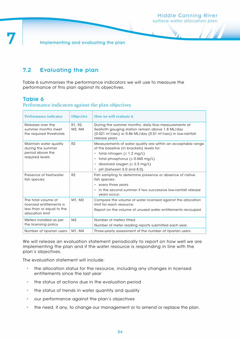
7.2 Evaluating the plan
Table 6 summarises the performance indicators we will use to measure the performance of this plan against its objectives.
Table 6Performance indicators against the plan objectives
Performance indicator Objective How we will evaluate it
Releases over the summer months meet the required thresholds
R1, R2, M3, M4
During the summer months, daily flow measurements at Seaforth gauging station remain above 1.8 ML/day (0.021 m3/sec) or 0.86 ML/day (0.01 m3/sec) in low-rainfall release years.
Maintain water quality during the summer period above the required levels
R2 Measurements of water quality are within an acceptable range of the baseline (in brackets) levels for:
• total nitrogen (≤ 1.2 mg/L)
• total phosphorus (≤ 0.065 mg/L)
• dissolved oxygen (≥ 2.5 mg/L)
• pH (between 5.0 and 8.0).
Presence of freshwater fish species
R2 Fish sampling to determine presence or absence of native fish species:
• every three years
• in the second summer if two successive low-rainfall release years occur.
The total volume of licensed entitlements is less than or equal to the allocation limit
M1, M2 Compare the volume of water licensed against the allocation limit for each resource.
Report on the volume of unused water entitlements recouped.
Meters installed as per the licensing policy
M2 Number of meters fitted.
Number of meter reading reports submitted each year.
Number of riparian users M1, M4 Three-yearly assessment of the number of riparian users.
We will release an evaluation statement periodically to report on how well we are implementing the plan and if the water resource is responding in line with the plan’s objectives.
The evaluation statement will include:
• the allocation status for the resource, including any changes in licensed entitlements since the last year
• the status of actions due in the evaluation period
• the status of trends in water quantity and quality
• our performance against the plan’s objectives
• the need, if any, to change our management or to amend or replace the plan.
AppendicesMiddle Canning River surface water allocation plan
(below Canning Dam to Kent Street Weir)
25
26
A
Middle Canning River surface water allocation plan
Appendix A Standard release schedule
Flo
w c
om
po
nen
tTa
sk/a
ctiv
ity
Trig
ger
for
acti
on
Info
rmat
ion
so
urc
eD
aily
vo
lum
es o
f w
ater
to
be
rele
ased
fro
m r
elea
se p
oin
tsTi
mef
ram
e
Sum
me
r m
inim
um
fl
ow
(in
clu
de
s d
isc
ha
rge
s re
qu
ire
d
to m
ain
tain
flo
w
co
nn
ec
tivi
ty,
ma
inta
in p
oo
l de
pth
a
s re
fug
e h
ab
ita
t,
ma
inta
in m
inim
um
flo
w o
ver
riff
les
for
ma
cro
inve
rte
bra
tes
an
d p
reve
nt
an
oxi
c
co
nd
itio
ns
in p
oo
ls).
Turn
on
re
lea
se
po
ints
to
ma
inta
in
sum
me
r flo
w.
Wh
en
dis
ch
arg
e a
t Se
afo
rth
ga
ug
ing
st
ati
on
fa
lls
be
low
9.3
ML/
da
y (0
.10
8 m
3/s
ec
) fo
r th
ree
co
nse
cu
tive
d
ays
in la
te s
pri
ng
.
Re
lea
se p
oin
t to
b
e t
urn
ed
on
to
st
an
da
rd r
ele
ase
sc
he
du
le w
ith
in 4
8 h
ou
rs o
f th
is e
ven
t.
Da
ily t
ele
me
try
da
ta o
n d
isc
ha
rge
a
nd
sta
ge
he
igh
t fo
r Se
afo
rth
g
au
gin
g s
tati
on
o
n D
ep
art
me
nt
of
Wa
ter
we
bsi
te.
The
vo
lum
es
liste
d b
elo
w f
or
ea
ch
re
lea
se p
oin
t a
re r
efe
rre
d t
o a
s th
e
‘sta
nd
ard
re
lea
se s
ch
ed
ule
’.
•A
ralu
en
: 2
.8 M
L/d
ay
•H
ill 6
0:
2.2
ML/
da
y
•B
ern
ard
St:
0
.7 M
L/d
ay
•O
rla
nd
o S
t:
1.6
ML/
da
y
•M
an
nin
g A
ve:
0.2
ML/
da
y
•G
osn
ells
Bri
dg
e:
1.0
ML/
da
y.
No
te t
ha
t re
lea
se p
oin
ts w
ill b
e
turn
ed
on
in t
wo
ph
ase
s, s
tart
ing
w
ith
Hill
60
, B
ern
ard
Str
ee
t a
nd
O
rla
nd
o S
tre
et
follo
we
d b
y th
e
rem
ain
ing
th
ree
re
lea
se p
oin
ts
wh
en
th
e d
isc
ha
rge
tri
gg
er
is
me
t a
ga
in.
Re
visi
on
of
me
an
d
aily
dis
ch
arg
e a
t Se
afo
rth
ga
ug
ing
st
ati
on
to
sta
rt o
n
1 O
cto
be
r. R
evi
sio
n
to c
on
tin
ue
u
nti
l me
an
da
ily
dis
ch
arg
e d
rop
s b
elo
w 9
.3 M
L/d
ay
an
d a
ll re
lea
se
po
ints
ha
ve b
ee
n
turn
ed
on
.
Sum
me
r m
inim
um
fl
ow
Info
rm t
he
D
ep
art
me
nt
of
Wa
ter
if m
ea
n
da
ily d
isc
ha
rge
at
Sea
fort
h g
au
gin
g
sta
tio
n f
alls
be
low
th
e r
ec
om
me
nd
ed
su
mm
er
min
imu
m
flow
.
If m
ea
n d
aily
d
isc
ha
rge
at
Sea
fort
h g
au
gin
g
sta
tio
n f
alls
b
elo
w 1
.8 M
L/d
ay
(0.0
21
m3/s
ec
) fo
r fiv
e c
on
sec
uti
ve
da
ys f
ollo
win
g t
he
st
art
of
sum
me
r flo
w.
Da
ily t
ele
me
try
da
ta o
n d
isc
ha
rge
a
nd
sta
ge
he
igh
t fo
r Se
afo
rth
g
au
gin
g s
tati
on
o
n D
ep
art
me
nt
of
Wa
ter
we
bsi
te.
To b
e n
eg
oti
ate
d b
etw
ee
n t
he
D
ep
art
me
nt
of
Wa
ter
an
d W
ate
r C
orp
ora
tio
n if
su
mm
er
flow
c
on
sist
en
tly
falls
be
low
1.8
ML/
da
y a
t Se
afo
rth
ga
ug
ing
sta
tio
n.
On
ce
re
lea
se p
oin
t va
lve
s h
ave
be
en
tu
rne
d o
n,
reg
ula
r re
visi
on
of
me
an
d
aily
dis
ch
arg
e a
t Se
afo
rth
ga
ug
ing
st
ati
on
to
en
sure
su
sta
ine
d m
inim
um
flo
w o
f a
t le
ast
1
.8 M
L/d
ay
at
Sea
fort
h g
au
gin
g
sta
tio
n.
Ad
dit
ion
al d
isc
ha
rge
fo
r sp
ora
dic
, w
inte
r o
r in
tera
nn
ua
l flo
ws
fro
m t
he
re
lea
se p
oin
ts m
ay
be
ma
de
at
the
dis
cre
tio
n
of
the
de
pa
rtm
en
t. T
he
se v
olu
me
s m
ay
be
va
rie
d a
s re
qu
ire
d t
o m
ee
t o
pe
rati
on
al a
nd
oth
er
req
uir
em
en
ts.
27
A
Middle Canning River surface water allocation plan
Appendix A Standard release schedule continued
Flo
w c
om
po
nen
tTa
sk/a
ctiv
ity
Trig
ger
for
acti
on
Info
rmat
ion
so
urc
eD
aily
vo
lum
es o
f w
ater
to
be
rele
ased
fro
m r
elea
se p
oin
tsTi
mef
ram
e
Re
lea
ses
fro
m b
ase
o
f C
an
nin
g D
am
Pro
vid
e f
low
of
ten
d
ays
’ d
ura
tio
n t
o
ma
inta
in m
inim
al
po
ol c
on
ne
cti
vity
, e
co
log
ica
l va
lue
s a
nd
pre
ven
t a
no
xic
c
on
dit
ion
s.
1 F
eb
rua
ry2
.5 M
L/d
ay
Ten
-da
y p
eri
od
st
art
ing
1 F
eb
rua
ry.
Turn
ing
off
su
mm
er
min
imu
m f
low
Turn
off
va
lve
s in
late
au
tum
n
or
ea
rly
win
ter
follo
win
g t
he
on
set
of
win
ter
rain
s.
On
ce
cu
mu
lati
ve
rain
fall
rec
eiv
ed
a
fte
r 1
Ap
ril r
ea
ch
es
40
mm
.
No
te t
ha
t th
is t
rigg
er
ma
y o
cc
ur
in M
ay
or
eve
n e
arly
Ju
ne
in
an
exc
ep
tion
ally
d
ry y
ea
r.
Da
ily r
ain
fall
da
ta f
or
Go
sne
lls
we
ath
er
sta
tio
n
on
Bu
rea
u o
f M
ete
oro
log
y (B
oM
) w
eb
site
.
No
t a
pp
lica
ble
.
No
te t
ha
t re
lea
se p
oin
ts w
ill b
e
turn
ed
off
tw
o a
t a
tim
e,
sta
rtin
g
fro
m t
he
fu
rth
est
do
wn
stre
am
an
d
en
din
g w
ith
th
e f
urt
he
st u
pst
rea
m
at
on
e-w
ee
k in
terv
als
.
Re
visi
on
of
rain
fall
da
ta f
rom
1 A
pri
l fr
om
Bo
M’s
G
osn
ells
we
ath
er
sta
tio
n.
Re
visi
on
to
c
on
tin
ue
un
til
trig
ge
r h
as
be
en
re
ac
he
d.
Fre
shw
ate
r c
ob
ble
r p
ass
ag
e f
low
s
(in
clu
de
s u
p t
o
thre
e h
igh
er-
volu
me
‘p
uls
e’
flow
s to
a
id u
pst
rea
m f
ish
m
igra
tio
n b
etw
ee
n
No
vem
be
r a
nd
Ja
nu
ary
).
Pro
vid
e f
low
p
uls
e(s
) o
f fiv
e
da
ys’
du
rati
on
fo
r u
pst
rea
m p
ass
ag
e
of
fre
shw
ate
r c
ob
ble
r.
On
ce
me
an
da
ily
dis
ch
arg
e a
t Se
afo
rth
ga
ug
ing
st
ati
on
fa
lls
be
low
9.3
ML/
da
y (0
.10
8 m
3/s
ec
) fo
r 1
5 c
on
sec
uti
ve
da
ys a
t a
ny
po
int
be
twe
en
th
e s
tart
of
No
vem
be
r a
nd
th
e
en
d o
f Ja
nu
ary
.
Da
ily t
ele
me
try
da
ta o
n d
isc
ha
rge
a
nd
sta
ge
he
igh
t fo
r Se
afo
rth
g
au
gin
g s
tati
on
o
n D
ep
art
me
nt
of
Wa
ter
we
bsi
te.
No
te t
ha
t th
e v
olu
me
s b
elo
w f
or
ea
ch
re
lea
se p
oin
t a
re t
o b
e
rele
ase
d f
or
five
da
ys o
nly
. A
fte
r fiv
e
da
ys,
volu
me
s m
ust
be
re
turn
ed
to
th
e s
tan
da
rd r
ele
ase
sc
he
du
le.
•A
ralu
en
: 2
.8 M
L/d
ay
•H
ill 6
0:
3.1
ML/
da
y
•B
ern
ard
St:
4
.5 M
L/d
ay
•O
rla
nd
o S
t:
2.5
ML/
da
y
•M
an
nin
g A
ve:
5.4
ML/
da
y
•G
osn
ells
Bri
dg
e:
2.5
ML/
da
y.
Re
visi
on
of
me
an
d
aily
dis
ch
arg
e
figu
res
for
Sea
fort
h
ga
ug
ing
sta
tio
n
fro
m 1
No
vem
be
r to
de
term
ine
w
he
the
r flo
w
ha
s fa
llen
be
low
9
.3 M
L/d
ay
for
15
co
nse
cu
tive
d
ays
. R
evi
sio
n t
o
co
nti
nu
e u
nti
l en
d
of
Jan
ua
ry.
No
te t
ha
t m
ore
th
an
on
e f
low
pu
lse
m
ay
be
re
qu
ire
d.
28
B Appendix B Low-rainfall-year release schedule
Middle Canning River surface water allocation plan
Flo
w c
om
po
nen
tTa
sk/a
ctiv
ity
Trig
ger
for
acti
on
Info
rmat
ion
so
urc
eD
aily
vo
lum
es o
f w
ater
to
be
rele
ased
fro
m r
elea
se p
oin
tsTi
mef
ram
e
Sum
me
r m
inim
um
fl
ow
(in
clu
de
s d
isc
ha
rge
s re
qu
ire
d
to m
ain
tain
min
ima
l flo
w c
on
ne
cti
vity
, m
ain
tain
po
ol
de
pth
as
refu
ge
h
ab
ita
t, m
ain
tain
m
inim
um
flo
w
ove
r ri
ffle
s fo
r m
ac
roin
vert
eb
rate
s a
nd
pre
ven
t a
no
xic
c
on
dit
ion
s in
po
ols
)
Turn
on
re
lea
se
po
ints
in la
te
spri
ng
to
ma
inta
in
min
ima
l flo
w.
Wh
en
dis
ch
arg
e a
t Se
afo
rth
ga
ug
ing
st
ati
on
fa
lls
be
low
6.9
ML/
da
y (0
.08
1 m
3/s
ec
) fo
r th
ree
co
nse
cu
tive
d
ays
in la
te s
pri
ng
.
Da
ily t
ele
me
try
da
ta o
n d
isc
ha
rge
a
nd
sta
ge
he
igh
t fo
r Se
afo
rth
g
au
gin
g s
tati
on
o
n D
ep
art
me
nt
of
Wa
ter
we
bsi
te.
The
vo
lum
es
liste
d b
elo
w f
or
ea
ch
re
lea
se p
oin
t a
re r
efe
rre
d t
o a
s th
e
‘low
-ra
infa
ll re
lea
se s
ch
ed
ule
’.
•A
ralu
en
: 1
.4 M
L/d
ay
•H
ill 6
0:
2.2
ML/
da
y
•B
ern
ard
St:
0
.7 M
L/d
ay
•O
rla
nd
o S
t:
1.6
ML/
da
y
•M
an
nin
g A
ve:
0.2
ML/
da
y
•G
osn
ells
Bri
dg
e:
0.5
ML/
da
y.
No
te t
ha
t re
lea
se p
oin
ts w
ill b
e
turn
ed
on
in t
wo
ph
ase
s, s
tart
ing
w
ith
Hill
60
, B
ern
ard
Str
ee
t a
nd
O
rla
nd
o S
tre
et
follo
we
d b
y th
e
rem
ain
ing
th
ree
re
lea
se p
oin
ts w
he
n
the
dis
ch
arg
e t
rig
ge
r is
me
t a
ga
in.
Re
visi
on
of
me
an
d
aily
dis
ch
arg
e a
t Se
afo
rth
ga
ug
ing
st
ati
on
to
sta
rt o
n
1 O
cto
be
r. R
evi
sio
n
to c
on
tin
ue
u
nti
l me
an
da
ily
dis
ch
arg
e d
rop
s b
elo
w 6
.9 M
L/d
ay
an
d a
ll re
lea
se
po
ints
ha
ve b
ee
n
turn
ed
on
.
Re
lea
ses
fro
m b
ase
o
f C
an
nin
g D
am
Pro
vid
e f
low
of
ten
d
ays
’ d
ura
tio
n t
o
ma
inta
in m
inim
al
po
ol c
on
ne
cti
vity
, e
co
log
ica
l va
lue
s a
nd
pre
ven
t a
no
xic
co
nd
itio
ns
1 F
eb
rua
ry2
.5 M
L/d
ay
Ten
-da
y p
eri
od
st
ari
ng
1 F
eb
rua
ry.
Turn
ing
off
su
mm
er
min
imu
m f
low
Turn
off
va
lve
s in
late
au
tum
n
or
ea
rly
win
ter
follo
win
g t
he
o
nse
t o
f w
inte
r ra
ins.
On
ce
cu
mu
lati
ve
rain
fall
rec
eiv
ed
a
fte
r 1
Ap
ril r
ea
ch
es
40
mm
.
No
te t
ha
t th
is t
rig
ge
r m
ay
oc
cu
r in
Ma
y o
r e
ven
ea
rly
Jun
e
in a
n e
xce
pti
on
ally
d
ry y
ea
r.
Da
ily r
ain
fall
da
ta f
or
Go
sne
lls
we
ath
er
sta
tio
n o
n
Bo
M w
eb
site
.
No
t a
pp
lica
ble
.
No
te t
ha
t re
lea
se p
oin
ts w
ill b
e
turn
ed
off
tw
o a
t a
tim
e,
sta
rtin
g
fro
m t
he
fu
rth
est
do
wn
stre
am
an
d
en
din
g w
ith
th
e f
urt
he
st u
pst
rea
m a
t o
ne
-we
ek
inte
rva
ls.
Re
visi
on
of
rain
fall
da
ta f
rom
1 A
pri
l fr
om
Bo
M’s
Go
sne
lls
we
ath
er
sta
tio
n.
Re
visi
on
to
c
on
tin
ue
un
til
trig
ge
r h
as
be
en
re
ac
he
d.
29
CAppendix C Map information and disclaimer
Middle Canning River surface water allocation plan
Flo
w c
om
po
nen
tTa
sk/a
ctiv
ity
Trig
ger
for
acti
on
Info
rmat
ion
so
urc
eD
aily
vo
lum
es o
f w
ater
to
be
rele
ased
fro
m r
elea
se p
oin
tsTi
mef
ram
e
Sum
me
r m
inim
um
fl
ow
(in
clu
de
s d
isc
ha
rge
s re
qu
ire
d
to m
ain
tain
min
ima
l flo
w c
on
ne
cti
vity
, m
ain
tain
po
ol
de
pth
as
refu
ge
h
ab
ita
t, m
ain
tain
m
inim
um
flo
w
ove
r ri
ffle
s fo
r m
ac
roin
vert
eb
rate
s a
nd
pre
ven
t a
no
xic
c
on
dit
ion
s in
po
ols
)
Turn
on
re
lea
se
po
ints
in la
te
spri
ng
to
ma
inta
in
min
ima
l flo
w.
Wh
en
dis
ch
arg
e a
t Se
afo
rth
ga
ug
ing
st
ati
on
fa
lls
be
low
6.9
ML/
da
y (0
.08
1 m
3/s
ec
) fo
r th
ree
co
nse
cu
tive
d
ays
in la
te s
pri
ng
.
Da
ily t
ele
me
try
da
ta o
n d
isc
ha
rge
a
nd
sta
ge
he
igh
t fo
r Se
afo
rth
g
au
gin
g s
tati
on
o
n D
ep
art
me
nt
of
Wa
ter
we
bsi
te.
The
vo
lum
es
liste
d b
elo
w f
or
ea
ch
re
lea
se p
oin
t a
re r
efe
rre
d t
o a
s th
e
‘low
-ra
infa
ll re
lea
se s
ch
ed
ule
’.
•A
ralu
en
: 1
.4 M
L/d
ay
•H
ill 6
0:
2.2
ML/
da
y
•B
ern
ard
St:
0
.7 M
L/d
ay
•O
rla
nd
o S
t:
1.6
ML/
da
y
•M
an
nin
g A
ve:
0.2
ML/
da
y
•G
osn
ells
Bri
dg
e:
0.5
ML/
da
y.
No
te t
ha
t re
lea
se p
oin
ts w
ill b
e
turn
ed
on
in t
wo
ph
ase
s, s
tart
ing
w
ith
Hill
60
, B
ern
ard
Str
ee
t a
nd
O
rla
nd
o S
tre
et
follo
we
d b
y th
e
rem
ain
ing
th
ree
re
lea
se p
oin
ts w
he
n
the
dis
ch
arg
e t
rig
ge
r is
me
t a
ga
in.
Re
visi
on
of
me
an
d
aily
dis
ch
arg
e a
t Se
afo
rth
ga
ug
ing
st
ati
on
to
sta
rt o
n
1 O
cto
be
r. R
evi
sio
n
to c
on
tin
ue
u
nti
l me
an
da
ily
dis
ch
arg
e d
rop
s b
elo
w 6
.9 M
L/d
ay
an
d a
ll re
lea
se
po
ints
ha
ve b
ee
n
turn
ed
on
.
Re
lea
ses
fro
m b
ase
o
f C
an
nin
g D
am
Pro
vid
e f
low
of
ten
d
ays
’ d
ura
tio
n t
o
ma
inta
in m
inim
al
po
ol c
on
ne
cti
vity
, e
co
log
ica
l va
lue
s a
nd
pre
ven
t a
no
xic
co
nd
itio
ns
1 F
eb
rua
ry2
.5 M
L/d
ay
Ten
-da
y p
eri
od
st
ari
ng
1 F
eb
rua
ry.
Turn
ing
off
su
mm
er
min
imu
m f
low
Turn
off
va
lve
s in
late
au
tum
n
or
ea
rly
win
ter
follo
win
g t
he
o
nse
t o
f w
inte
r ra
ins.
On
ce
cu
mu
lati
ve
rain
fall
rec
eiv
ed
a
fte
r 1
Ap
ril r
ea
ch
es
40
mm
.
No
te t
ha
t th
is t
rig
ge
r m
ay
oc
cu
r in
Ma
y o
r e
ven
ea
rly
Jun
e
in a
n e
xce
pti
on
ally
d
ry y
ea
r.
Da
ily r
ain
fall
da
ta f
or
Go
sne
lls
we
ath
er
sta
tio
n o
n
Bo
M w
eb
site
.
No
t a
pp
lica
ble
.
No
te t
ha
t re
lea
se p
oin
ts w
ill b
e
turn
ed
off
tw
o a
t a
tim
e,
sta
rtin
g
fro
m t
he
fu
rth
est
do
wn
stre
am
an
d
en
din
g w
ith
th
e f
urt
he
st u
pst
rea
m a
t o
ne
-we
ek
inte
rva
ls.
Re
visi
on
of
rain
fall
da
ta f
rom
1 A
pri
l fr
om
Bo
M’s
Go
sne
lls
we
ath
er
sta
tio
n.
Re
visi
on
to
c
on
tin
ue
un
til
trig
ge
r h
as
be
en
re
ac
he
d.
Datum and projection information
Vertical datum: Australian Height Datum (AHD)
Horizontal datum: Geocentric Datum of Australia 94
This map is a product of the Department of Water, Water Assessment and Allocation Division and was printed as shown.
This map was produced with the intent that it be used for information purposes at the scale as shown when printing.
While the Department of Water has made all reasonable efforts to ensure the accuracy of this data, the department accepts no responsibility for any inaccuracies and anyone relying on this data does so at their own risk.
Sources
The Department of Water acknowledges the following datasets and their custodians in the production of this map:
WA Coastline, WRC (Poly) – DoW – 20/07/2006
Hydrography, Linear (Hierarchy) – DoW – 05/11/2007
State Roads – DOLA – 06/01/1999
Population Centres – GA – 13/11/1998
30
Middle Canning River surface water allocation plan
Shortened forms
List of shortened forms
ANZECC Australian and New Zealand Environment Conservation Council
ARMCANZ Agriculture and Resource Management Council of Australia and New Zealand
BoM Bureau of Meteorology
CSIRO Commonwealth Scientific and Industrial Research Organisation
DoP Department of Planning
DoW Department of Water
EWR Ecological water requirement
IWSS Integrated Water Supply Scheme
NHMRC National Health and Medical Research Council
NRMMC Natural Resource Management Ministerial Council
SAT State Administrative Tribunal
SRT Swan River Trust
WAPC West Australian Planning Commission
WRC Water and Rivers Commission (now Department of Water)
Volumes of water
One litre 1 litre 1 litre (L)
One thousand litres 1000 litres 1 kilolitre (kL)
One million litres 1 000 000 litres 1 megalitre (ML)
One thousand million litres 1 000 000 000 litres 1 gigalitre (GL)
31
Middle Canning River surface water allocation plan
Glossary
Abstraction The permanent or temporary withdrawal of water from any source of supply, so that it is no longer part of the resources of the locality.
Allocation limit Annual volume of water set aside for consumptive use from a water resource. This includes water available for licensing and water for uses exempt from licensing.
Baseflow The component of streamflow supplied by groundwater discharge.
Catchment The area of land from which rainfall runoff contributes to a single watercourse, wetland or aquifer.
Climate change A change of climate that is attributed directly or indirectly to human activity that alters the composition of the global atmosphere and which is in addition to natural climate variability observed over comparable time periods.
Commercial use Water taken from a resource that is directly or indirectly used for commercial purposes. This includes water taken for public and private purposes and water stored in a dam.
Consumptive use The use of water for private-benefit consumptive purposes including irrigation, industry, urban and stock and domestic use.
Dam Embankments constructed to store or regulate surface water flow. A dam can be constructed in or outside a watercourse.
Ecological water requirement
The water regime needed to maintain the ecological values (including assets, functions and processes) of water-dependent ecosystems at a low level of risk.
Releases The releases made from 2007 onwards to meet key ecological functions, benefit users and provide for the cultural and social values of the river.
Ecosystem A community or assemblage of communities or organisms, interacting with one another, and the specific environment in which they live and with which they also interact (e.g. a lake) to include all the biological, chemical and physical resources and the interrelationships and dependencies that occur between those resources.
Evaporation Loss of water from the water surface or soil surface by vaporisation due to solar radiation.
Environment Living things, their physical, biological and social surroundings, and the interactions between all of these.
Exempt use Water use that is not required to be licensed under the Rights in Water and Irrigation Act 1914. This is sometimes referred to as stock and domestic use or a riparian right.
Flow Streamflow – may be measured as m3/yr, m3/d or ML/yr. May also be referred to as discharge.
Flow regime A description of the variation of the flow rate over time.
Licence A formal permit which entitles the licenceholder to abstract water from a proclaimed watercourse, wetland or underground source.
Licensed use Total (annual) volume of surface water that has been allocated to licensees as entitlements. This may include what is taken for public and private purposes and what can be taken to be stored in a dam.
Off-stream storage Storages (such as farm dams, turkey’s nest dams) that are not on defined waterways or watercourses and primarily store water either extracted from rivers or aquifers, or from flood water emanating from rivers or from local catchment runoff.
On-stream storage Storages (such as farm dams) that are built on or within a defined waterway or watercourse.
32
Middle Canning River surface water allocation plan
Glossary
Over-allocation Refers to situations where with full development of water access entitlements in a particular system, the total volume of water able to be extracted by entitlement holders at a given time exceeds the environmentally sustainable level of extraction for that system.
Proclaimed resource
An area proclaimed under the Rights in Water and Irrigation Act 1914 to enable water licensing, which is used for water allocation planning and management. Surface water is proclaimed as a surface water area, irrigation district or proclaimed river under Part III Division 1B s.6 of the Act.
Social value A particular in-situ quality, attribute or use that is important for public benefit, welfare, state or health (physical and spiritual).
Stock and domestic water use
Water that is used for ordinary domestic purposes associated with a dwelling, such as water for cattle or stock other than those being raised under intensive conditions; water for up to 0.2 ha (if groundwater) or 2 ha (if surface water) of garden from which no produce is sold. This abstraction is generally considered a basic right.
Surface water Water flowing or held in streams, rivers and wetlands on the surface of the landscape.
Sustainability Meeting the needs of current and future generations by integrating environmental protection, social advancement and economic prosperity.
Transferable (tradeable) water entitlement
The ability to transfer or trade a water entitlement, or a part thereof, to another person within a common water resource.
Unlicensed use Water use that is currently exempt from licensing under the Rights in Water and Irrigation Act 1914. For surface water, this includes water taken:• for small-scale household purposes and non-intensive stock
watering• from springs and wetlands wholly within a property• from streams arising on a property• in areas not proclaimed• by plantations.
Use Water taken for private-benefit consumptive purposes including irrigation, industry, urban, stock and domestic, aesthetics, lifestyle and storage.
Watercourse a. Any river, creek, stream or brook in which water flowsb. Any collection of water (including a reservoir) into, through or out of
which anything coming within paragraph (a) flowsc. Any place where water flows that is prescribed by local by-laws to
be a watercourse.A watercourse includes the bed and banks of anything referred to in paragraph (a), (b) or (c).
Water entitlement The quantity of water that a person is entitled to abstract annually in accordance with the Rights in Water and Irrigation Act 1914 or a licence.
Water efficiency Increasing water supply efficiency and water demand efficiency to minimise the taking and use of water.
Water meter A device for measuring or estimating the volume or flow of water that is approved under the Rights in Water and Irrigation Act 1914.
Waterways All streams, creeks, stormwater drains, rivers, estuaries, coastal lagoons, inlets and harbours.
33
Middle Canning River surface water allocation plan
References
Australian and New Zealand Environment Conservation Council & Agriculture Resource Management Council of Australia and New Zealand 2000, The Australian and New Zealand guidelines for fresh and marine water quality, paper no. 4, Commonwealth of Australia, Canberra.
Commonwealth Scientific and Industrial Research Organisation (CSIRO) 2009, Water yields and demands in south west Western Australia: a report to the Australian Government from the CSIRO South-West Sustainable Yields Project, available from <www.csiro.au/partnerships/SWSY.html>.
Department of Water 2009a, Strategic policy no. 5.03 – Metering the taking of water, Department of Water, Perth.
—2009b, Guidelines for water meter installation, Department of Water, Perth.
—2009c, Operational policy no. 1.2 – Policy on water conservation and efficiency plans: achieving water use efficiency gains through water licensing, Department of Water, Perth.
—2009d, Operational policy no. 5.12 – Hydrogeological reporting associated with a groundwater well licence, Department of Water, Perth.
—2009e, Rights in Water and Irrigation (Approved Meters) Order 2009 fact sheet, Department of Water, Perth.
—2010a, Operational policy no. 5.08 – Use of operating strategies in the water licensing process, Department of Water, Perth.
—2010b, Operational policy no. 5.13 – Water entitlement transactions for Western Australia, Department of Water, Perth.
—2010c, Lower Canning River surface water allocation plan: for public comment, Department of Water, Perth.
—2012, Middle Canning River surface water allocation plan – statement of response, Department of Water, Perth.
National Health and Medical Research Council & Natural Resource Management Ministerial Council 2004, National water quality management strategy –Australian drinking water guidelines 6, National Health and Medical Research Council and Natural Resource Management Ministerial Council, Government of Australia, Canberra.
Radin, L, Pauli, N, La Spina, K, Braimbridge, M & Malseed, B 2010, Ecological water requirements for the lower Canning River, Department of Water, Perth.
34
Middle Canning River surface water allocation plan
References
Swan River Trust 2002, Caring for the Canning: a plan to revitalise the Canning, Southern and Wungong rivers, Swan River Trust, Perth.
Water and Rivers Commission 1996, Canning River interim allocation policy, Water and Rivers Commission, Perth.
—2002, Statewide policy no. 5 – Environmental water provisions policy for Western Australia, Water and Rivers Commission, Perth.
—2003, Statewide policy no. 11 – Management of unused licensed water entitlements, Water and Rivers Commission, Perth.
35
Middle Canning River surface water allocation plan
Notes
36
Middle Canning River surface water allocation plan
Notes
Looking after all our water needs
Water resource allocationplanning seriesReport no 37September 2012
Department of Water168 St Georges Terrace, Perth, Western Australia
PO Box K822 Perth Western Australia 6842Phone: 08 6364 7600
Fax: 08 6364 7601www.water.wa.gov.au
9071 100 0912
Mid
dle
Ca
nn
ing
Riv
er su
rfac
e w
ate
r allo
ca
tion
pla
n
Sep
tem
be
r 2012
Middle Canning Riversurface water allocation plan(below Canning Dam to Kent Street Weir)