22
Mineral Resource Potential of the NB-20-4 Quadrangle, Eastern Guayana Shield, Bolfvar State, Venezuela U.S. GEOLOGICAL SURVEY BULLETIN 1960
Mineral Resource Potential of the NB-20-4 Quadrangle, Eastern Guayana Shield, Bolfvar State, Venezuela
U.S. GEOLOGICAL SURVEY BULLETIN 1960

Mineral Resource Potential of the NB-20-4 Quadrangle, Eastern Guayana Shield, Bolfvar State, Venezuela
By JEFFREY C. WYNN and GARY B. SIDDER
U.S. GEOLOGICAL SURVEY BULLETIN 1960
U.S. DEPARTMENT OF THE INTERIOR
MANUEL LUJAN, JR., Secretary
U.S. GEOLOGICAL SURVEY
Dallas L. Peck, Director
Any use of trade, product, or firm names in this publication is for descriptive purposes only and does not imply endorsement by the U.S. Government.
UNITED STATES GOVERNMENT PRINTING OFFICE: 1991
For sale by the Books and Open-File Reports Section U.S. Geological Survey Federal Center Box 25425 Denver, CO 80225
Library of Congress Cataloging-in-Publication Data
Wynn, Jeffrey C. Mineral resource potential of the NB-20-4 Quadrangle, Eastern Guayana
Shield, Bolivar State, Venezuela I by Jeffrey C. Wynn and Gary B. Sidder. p. em. - (U.S. Geological Survey bulletin ; 1960)
Includes bibliographical references. Supt. of Docs. no.: 119.3:1960 1. Mines and mineral resources-Venezuela-Bolivar
(State) 2. Geology-Venezuela-Bolfvar (State) I. Sidder, Gary B. II. Title. Ill. Title: Guayana Shield, Bolivar State, Venezuela. IV. Series. QE75.B9 no. 1960 [TN54] 557.3 s-dc20 90-22796 [333.8'5'098763] CIP
CONTENTS Abstract 1 Introduction 1 Summary of geologic data 2 Summary of aeromagnetic data 5 The relation between greenstone belts and granitic intrusions 6 Mineral resource potential 8
Domain 1-Vuelvan Caras and Purgatorio 8 Domain 2-Marwani 10 Domain 3-South Bochinche 11 Domain 4-Nuria 11 Domain 5-Cerro San Cristobal 11 Domain 6-El Callao Formation 11 Domain ?-Greenstone-belt rocks 11 Domain 8-La Rosa 12 Domain 9-Placer gold 13
Mineral-deposit density and resource studies 13 Summary and conclusions 14 References cited 14
PLATES
[Plates are in pocket]
1. Geologic map and domains of tracts pem1issive for certain deposit types in the NB-20-4 quadrangle
2. Map showing interpretation of aeromagnetic data for the NB-20-4 quadrangle
FIGURES
1. Location map of the NB-20-4 quadrangle 2 2. Map showing geographic and geologic features and mining districts, NB-20-4
quadrangle 2 3. Stratigraphic chart of rock units in the NB-20-4 quadrangle 4 4. Diagram showing possible subsurface relationships between greenstone-belt rocks
and intruding granitic bodies 7 5. Diagram showing possible three-dimensional configuration of greenstone-belt arcu-
ate features in the NB-20-4 quadrangle 7
TABLES
1. Geologic map units for the NB-20-4 quadrangle 3 2. Gold mines and prospects in the NB-20-4 quadrangle 9 3. Estimates of gold resources in the NB-20-4 quadrangle for three confidence
levels 13
Contents Ill


Mineral Resource Potential of the NB-20-4 Quadrangle, Eastern Guayana Shield, Bolfvar State, Venezuela
By Jeffrey C. Wynn and Gary B. Sidder
ABSTRACT
Early Proterozoic rocks typical of greenstone-granite terranes underlie eastern Venezuela. The greenstone-belt rocks in the NB-20-4 quadrangle (1 o by 11/2°) consist of submarine sequences with mafic-ultramafic intrusions, mafic to felsic volcanic, volcaniclastic, and turbiditic rocks, and chemical and detrital sedimentary rocks. Granitic rocks and granitic gneiss of the Supamo Complex intrude the greenstone belts. In the greenstone-belt rocks, the metamorphic grade ranges from subgreenschist facies in the interior of belts to amphibolite facies at contacts with intrusions. Diabase dikes and a ringlike complex of diabase or gabbro, such as the Laguna dike and Nuria complex, respectively, are younger than the greenstonegranite rocks. Positive aeromagnetic anomalies throughout the quadrangle coincide closely with mapped greenstone-belt rocks and show a larger proportion of greenstone-belt rocks than is shown on the geologic map, especially on the western margins of the greenstone belts. In one example, magnetic data demonstrate that the greenstone belt extends as much as 15 km (kilometers) farther west-southwest of the westernmost geologically mapped outcrop; the surficial area covered by greenstone-belt rocks may actually be more than 30 percent higher than what is shown on the geologic map. Structural data collected from the field and interpretation of side-looking airborne radar and aeromagnetic data have identified several major fault or shear zones in the quadrangle.
Several mineral-deposit models are possible in quadrangle NB-20-4, based on the geologic, geophysical, and structural characteristics of the rocks and on known mineral occurrences. These mineral-deposit models include: (1) lowsulfide gold-quartz veins; (2) placer gold with platinum-group elements (PGE); (3) dunitic nickel-copper; (4) kuroko-type massive sulfide; (5) laterite-type bauxite; (6) secondarily enriched volcanogenic manganese; and possibly (7) Homestake-type gold deposits. Between 16 and 27 low-sulfide gold-quartz vein-type deposits may be present within the
Manuscript approved for publication September 27, 1990.
quadrangle based on a model of mineral-deposit density within a given area of greenstone-belt rocks in similar geologic environments around the world. At present, two gold vein deposits are being exploited within the quadrangle, and one other lode deposit at the Vuelvan Caras-Purgatorio gold district, which may be more representative of a gold-rich porphyry copper deposit, is also being worked. Placer-gold deposits are also being mined within the quadrangle, as evidenced by small-scale mining activity.
INTRODUCTION
The U.S. Geological Survey established a scientific advisory group in southeastern Venezuela in September, 1987, that is charged with technical training, upgrading of scientific facilities, and assembling a mineral resource assessment of the Venezuelan Guayana (also spelled Gui
ana) Shield. This work is being accomplished in close cooperation with Corporacfon Venezolana de Guayana
Tecnica Minera, C.A., (CVG-TECMIN) a mineral
exploration company wholly owned by the Venezuelan government. As an initial part of this effort, a 1° by ! 1/2°
quadrangle (designated NB-20-4 by the National Cartographic Agency of Venezuela) for which the highest
quality geologic data were available was selected for a
mineral-resource assessment. This assessment is part of ongoing mineral exploration in the quadrangle, and it is intended to be a base upon which to construct a broader
mineral-resource evaluation of the more than 450,000 km2
(square kilometers) of Precambrian terrane lying south and east of the Orinoco River within Venezuelan borders. Dense jungle cover and poor exposures of rocks throughout most of the quadrangle have made geologic mapping difficult. Therefore, this study has combined field and photogeologic data with aeromagnetic data to complete the mineral
resource assessment.
Introduction
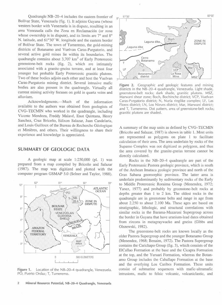
60°00' Quadrangle NB-20-4 includes the eastern frontier of so ~6::_:_1°-:-3~o· _____________ """"l7'7~-~-~ Bolfvar State, Venezuela (fig. 1). It adjoins Guyana (whose western border with Venezuela is in dispute, resulting in an area Venezuela calls the Zona en Reclamaci6n (or zone whose ownership is in dispute), and its limits are 7° and 8° N. latitude, and 61 °30' W. longitude and the eastern border of Bolfvar State. The town of Tumeremo, the gold-mining districts of Botanamo and Vuelvan Caras-Purgatorio, and several active gold mines lie within its boundaries. The quadrangle contains about 3,707 km2 of Early Proterozoic greenstone-belt rocks (fig. 2), which are intimately associated with a granite-gneiss terrane, and at least four younger but probable Early Proterozoic granitic plutons. Two of these bodies adjoin each other and host the Vuelvan Caras-Purgatorio mining district. Several intrusive mafic bodies are also present in the quadrangle. Virtually all current mining activity focuses on gold in quartz veins and alluvium.
Acknowledgments.-Much of the information available to the authors was obtained from geologists of CVG-TECMIN who worked in the quadrangle, including Vicente Mendoza, Freddy Malave, Enot Quintana, Henry Sanchez, Cruz Bricefio, Edixon Salazar, Juan Candelaria, and Louis Guilloux of the Bureau de Recherche Geologique et Minieres, and others. Their willingness to share their experience and knowledge is appreciated.
SUMMARY OF GEOLOGIC DATA
A geologic map at scale 1 :250,000 (pl. 1) was prepared from a map compiled by Briceno and Salazar (1987). The map was digitized and plotted with the computer program GSMAP 5.0 (Selner and Taylor, 1988).
62° 10°
61° 60° 59°
ATLANTIC OCEAN
, so
~ 20-4 ', ZONE IN , DISPUTE \
60 ) •,
~ GUAYANA " 40 SHIELD ~("'' . ~f.:z.uc , : 't, ~. ~'\. .¢'-o/.~\.. :
AMAZON ... • • ( Y> ) ' zo FEDERAL t "- ·' D\ \ TERRITORY '
l
' ·~- ' ' oo . .. ....__ ,./"-· " ·- v-.... _,. ~/
500 KILOMETERS
L__IL_J___JL_L.__I
Figure 1. Location of the NB-20-4 quadrangle, Venezuela. PO, Puerto Ordaz; T, Tumeremo.
2 Mineral Resource Potential, NB-20-4 Quadrangle, Venezuela
ZONE IN DISPUTE
Figure 2. Geographic and geologic features and mining districts in the NB-20-4 quadrangle, Venezuela. Light shade, greenstone-belt rocks; dark shade, granitic plutons. MSZ, Marwani shear zone; Boch, Bochinche district; VCP, Vuelvan Caras-Purgatorio district; N, Nuria ringlike complex; LF, Las Flores district; LN, Los Nieves district; Mar, Marwani district; and T, Tumeremo. Dot pattern, area of greenstone-belt rocks; granitic plutons are shaded.
A summary of the map units as defined by CVG-TECMIN (Briceno and Salazar, 1987) is shown in table 1. Most units are represented as polygons on plate 1 to facilitate calculation of their area. The area underlain by rocks of the Supamo Complex was not digitized as polygons, and thus the area covered by the granite-gneiss terrane cannot be directly calculated.
Rocks in the NB-20-4 quadrangle are part of the Early Proterozoic Pastora geologic province, which is south of the Archean Imataca geologic province and north of the Gran Sabana geomorphic province. The latter area is underlain predominantly by sedimentary rocks of the Early to Middle Proterozoic Roraima Group (Menendez, 1972; Yanez, 1977) and probably by greenstone-belt rocks at depths greater than 1 to 2 km. The oldest rocks in the quadrangle are in greenstone belts and range in age from about 2,250 to about 2.100 Ma. These ages are based on stratigraphic, lithologic, and structural correlations with similar rocks in the Barama-Mazaruni Supergroup across the border in Guyana that have uranium-lead dates obtained from zircons in metagraywacke and gneiss (Gibbs and Olszewski, 1982).
The greenstone-belt rocks are known locally as the older Pastora Supergroup and the younger Botanamo Group (Menendez, 1968; Benaim, 1972). The Pastora Supergroup contains the Carichapo Group (fig. 3), which consists of the ElCallao Formation at the base and the Cicapra Formation at the top, and the Yuruari Formation, whereas the Botanamo Group includes the Caballape Formation at the base and the overlying Los Caribes Formation. These units consist of submarine sequences with mafic-ultramafic intrusions, mafic to felsic volcanic, volcaniclastic, and
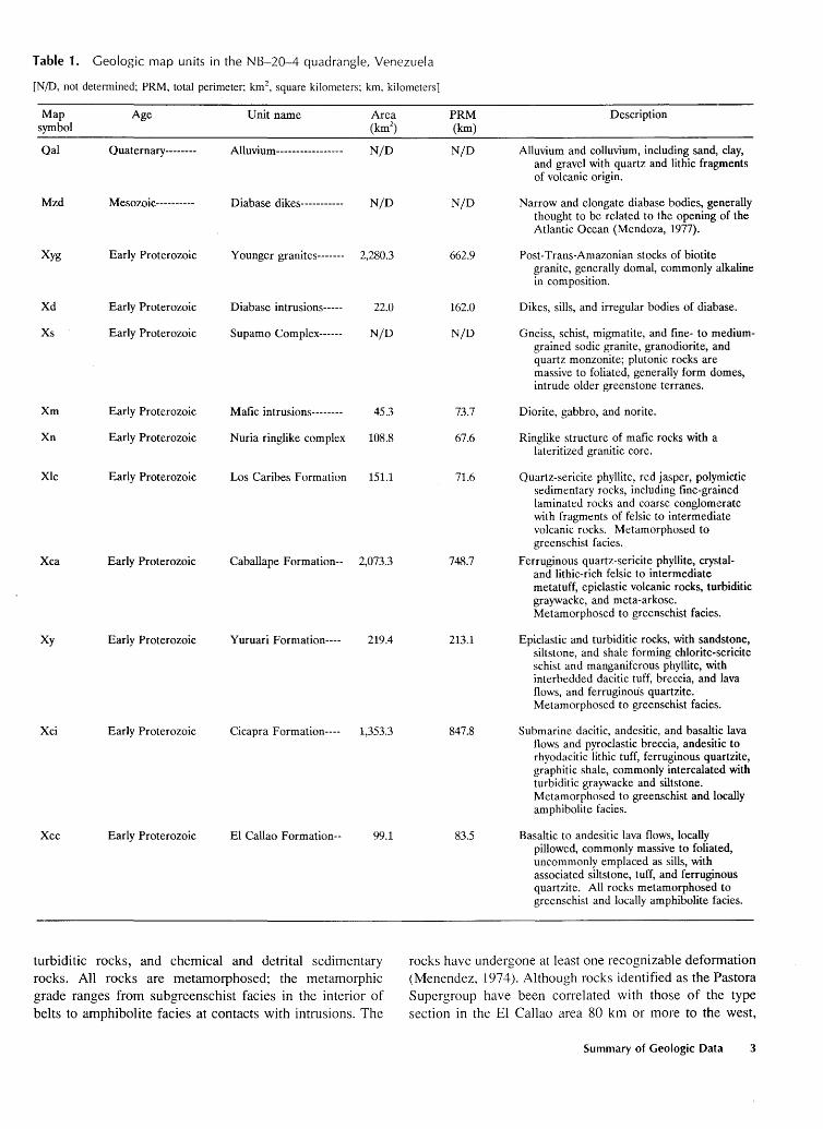
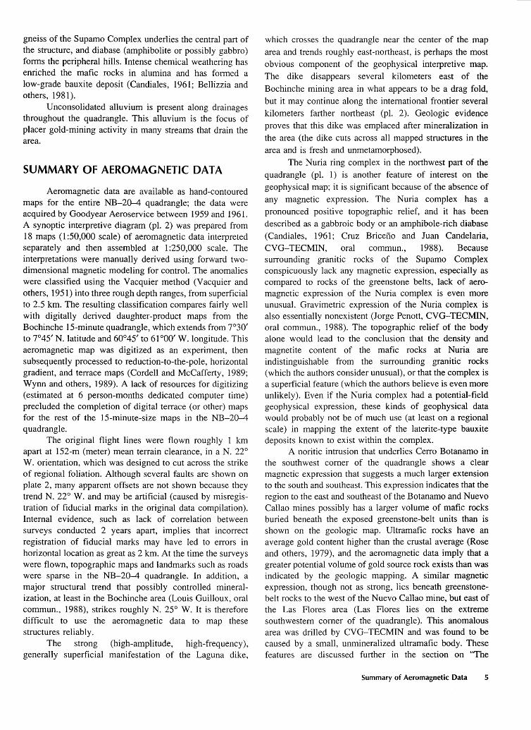
Table 1. Geologic map units in the N 8-20-4 quadrangle, Venezuela
[N/D, not detennined; PRM, total perimeter; km2, square kilometers; km, kilometers]
Map Age Unit name Area symbol (km2
)
Qal Quaternary-------- Alluvium----------------- N/D
Mzd Mesozoic---------- Diabase dikes----------- N/D
Xyg Early Proterozoic Younger granites------- 2,280.3
Xd Early Proterozoic Diabase intrusions----- 22.0
Xs Early Proterozoic Supamo Complex------ N/D
Xm Early Proterozoic Mafic intrusions-------- 45.3
Xn Early Proterozoic Nuria ringlike complex 108.8
Xlc Early Proterozoic Los Caribes Formation 151.1
Xca Early Proterozoic Caballape Formation-- 2,073.3
Xy Early Proterozoic Yuruari Formation---- 219.4
Xci Early Proterozoic Cicapra Formation---- 1,353.3
Xec Early Proterozoic El Callao Formation-- 99.1
turbiditic rocks, and chemical and detrital sedimentary rocks. All rocks are metamorphosed; the metamorphic grade ranges from subgreenschist facies in the interior of belts to amphibolite facies at contacts with intrusions. The
PRM Description (km)
NjD Alluvium and colluvium, including sand, clay, and gravel with quartz and lithic fragments of volcanic origin.
N/D Narrow and elongate diabase bodies, generally thought to be related to the opening of the Atlantic Ocean (Mendoza, 1977).
662.9 Post-Trans-Amazonian stocks of biotite granite, generally domal, commonly alkaline in composition.
162.0 Dikes, sills, and irregular bodies of diabase.
N/D Gneiss, schist, migmatite, and fine- to medium-grained sodic granite, granodiorite, and quartz monzonite; plutonic rocks are massive to foliated, generally form domes, intrude older greenstone terranes.
73.7 Diorite, gabbro, and norite.
67.6 Ringlike structure of mafic rocks with a lateritized granitic core.
71.6 Quartz-sericite phyllite, red jasper, polymictic sedimentary rocks, including fine-grained laminated rocks and coarse conglomerate with fragments of felsic to intermediate volcanic rocks. Metamorphosed to greenschist facies.
748.7 Ferruginous quartz-sericite phyllite, crystal-and lithic-rich felsic to intermediate metatuff, epiclastic volcanic rocks, turbiditic graywacke, and meta-arkose. Metamorphosed to greenschist facies.
213.1 Epiclastic and turbiditic rocks, with sandstone, siltstone, and shale forming chlorite-sericite schist and manganiferous phyllite, with interbedded dacitic tuff, breccia, and lava flows, and ferruginous quartzite. Metamorphosed to greenschist facies.
847.8 Submarine dacitic, andesitic, and basaltic lava flows and pyroclastic breccia, andesitic to rhyodacitic lithic tuff, ferruginous quartzite, graphitic shale, commonly intercalated with turbiditic graywacke and siltstone. Metamorphosed to greenschist and locally amphibolite facies.
83.5 Basaltic to andesitic lava flows, locally pillowed, commonly massive to foliated, uncommonly emplaced as sills, with associated siltstone, tuff, and ferruginous quartzite. All rocks metamorphosed to greenschist and locally amphibolite facies.
rocks have undergone at least one recognizable deformation (Menendez, 1974). Although rocks identified as the Pastora Supergroup have been correlated with those of the type section in the El Callao area 80 km or more to the west,
Summary of Geologic Data 3
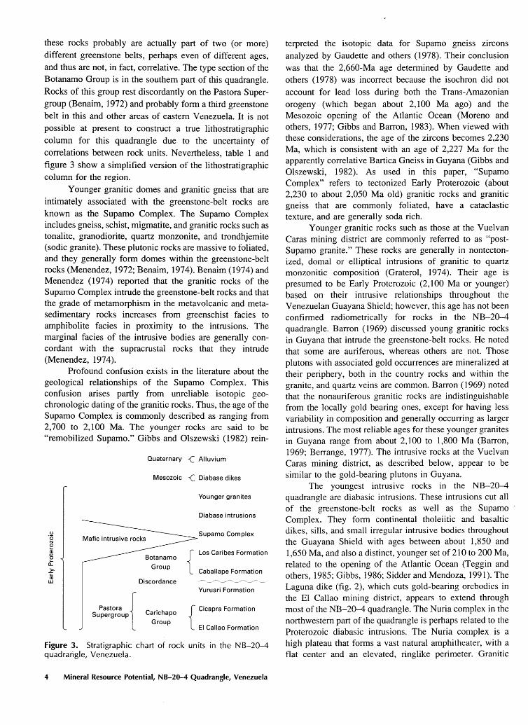
these rocks probably are actually part of two (or more) different greenstone belts, perhaps even of different ages, and thus are not, in fact, correlative. The type section of the Botanamo Group is in the southern part of this quadrangle. Rocks of this group rest discordantly on the Pastora Supergroup (Benaim, 1972) and probably form a third greenstone belt in this and other areas of eastern Venezuela. It is not possible at present to construct a true lithostratigraphic column for this quadrangle due to the uncertainty of correlations between rock units. Nevertheless, table 1 and figure 3 show a simplified version of the lithostratigraphic column for the region.
Younger granitic domes and granitic gneiss that are intimately associated with the greenstone-belt rocks are known as the Supamo Complex. The Supamo Complex includes gneiss, schist, migmatite, and granitic rocks such as tonalite, granodiorite, quartz monzonite, and trondhjemite (sodic granite). These plutonic rocks are massive to foliated, and they generally form domes within the greenstone-belt rocks (Menendez, 1972; Benaim, 1974). Benaim (1974) and Menendez (1974) reported that the granitic rocks of the Supamo Complex intrude the greenstone-belt rocks and that the grade of metamorphism in the metavolcanic and metasedimentary rocks increases from greenschist facies to amphibolite facies in proximity to the intrusions. The marginal facies of the intrusive bodies are generally concordant with the supracrustal rocks that they intrude (Menendez, 1974).
Profound confusion exists in the literature about the geological relationships of the Supamo Complex. This confusion arises partly from unreliable isotopic geochronologic dating of the granitic rocks. Thus, the age of the Supamo Complex is commonly described as ranging from 2, 700 to 2, 100 Ma. The younger rocks are said to be "remobilized Supamo." Gibbs and Olszewski (1982) rein-
(.)
'6 N 0 Q; 0 c': > -;:::: co w
Quaternary -<( Alluvium
Mesozoic -<( Diabase dikes
Discordance
Pastora { . Supergroup Canchapo
Group
Younger granites
Diabase intrusions
Supamo Complex
Los Caribes Formation
Caballape Formation
Yuruari Formation
{
Cicapra Formation
El Callao Formation
Figure 3. Stratigraphic chart of rock units in the NB-20-4 quadrangle, Venezuela.
4 Mineral Resource Potential, NB-20-4 Quadrangle, Venezuela
terpreted the isotopic data for Supamo gneiss zircons analyzed by Gaudette and others (1978). Their conclusion was that the 2,660-Ma age determined by Gaudette and others (1978) was incorrect because the isochron did not account for lead loss during both the Trans-Amazonian orogeny (which began about 2,100 Ma ago) and the Mesozoic opening of the Atlantic Ocean (Moreno and others, 1977; Gibbs and Barron, 1983 ). When viewed with these considerations, the age of the zircons becomes 2,230 Ma, which is consistent with an age of 2,227 Ma for the apparently correlative Bartica Gneiss in Guyana (Gibbs and Olszewski, 1982). As used in this paper, "Supamo Complex" refers to tectonized Early Proterozoic (about 2,230 to about 2,050 Ma old) granitic rocks and granitic gneiss that are commonly foliated, have a cataclastic texture, and are generally soda rich.
Younger granitic rocks such as those at the Vuelvan Caras mining district are commonly referred to as "postSupamo granite." These rocks are generally in nontectonized, domal or elliptical intrusions of granitic to quartz monzonitic composition (Graterol, 1974). Their age is presumed to be Early Proterozoic (2, 100 Ma or younger) based on their intrusive relationships throughout the Venezuelan Guayana Shield; however, this age has not been confirmed radiometrically for rocks in the NB-20-4 quadrangle. Barron ( 1969) discussed young granitic rocks in Guyana that intrude the greenstone-belt rocks. He noted that some are auriferous, whereas others are not. Those plutons with associated gold occurrences are mineralized at their periphery, both in the country rocks and within the granite, and quartz veins are common. Barron (1969) noted that the nonauriferous granitic rocks are indistinguishable from the locally gold bearing ones, except for having less variability in composition and generally occurring as larger intrusions. The most reliable ages for these younger granites in Guyana range from about 2,100 to 1 ,800 Ma (Barron, 1969; Berrange, 1977). The intrusive rocks at the Vuelvan Caras mining district, as described below, appear to be similar to the gold-bearing plutons in Guyana.
The youngest intrusive rocks in the NB-20-4 quadrangle are diabasic intrusions. These intrusions cut all of the greenstone-bdt rocks as well as the Supamo Complex. They form continental tholeiitic and basaltic dikes, sills, and small irregular intrusive bodies throughout the Guayana Shield with ages between about 1,850 and 1 ,650 Ma, and also a distinct, younger set of 210 to 200 Ma, related to the opening of the Atlantic Ocean (Teggin and others, 1985; Gibbs, 1986; Sidder and Mendoza, 1991 ). The Laguna dike (fig. 2), which cuts gold-bearing orebodies in the El Callao mining district, appears to extend through most of the NB-20-4 quadrangle. The Nuria complex in the northwestern part of the quadrangle is perhaps related to the Proterozoic diabasic intrusions. The Nuria complex is a high plateau that forms a vast natural amphitheater, with a flat center and an elevated, ringlike perimeter. Granitic
gneiss of the Supamo Complex underlies the central part of the structure, and diabase (amphibolite or possibly gabbro) forms the peripheral hills. Intense chemical weathering has enriched the mafic rocks in alumina and has formed a low-grade bauxite deposit (Candiales, 1961; Bellizzia and others, 1981).
Unconsolidated alluvium is present along drainages throughout the quadrangle. This alluvium is the focus of placer gold-mining activity in many streams that drain the area.
SUMMARY OF AEROMAGNETIC DATA
Aeromagnetic data are available as hand-contoured maps for the entire NB-20--4 quadrangle; the data were acquired by Goodyear Aeroservice between 1959 and 1961. A synoptic interpretive diagram (pl. 2) was prepared from 18 maps (1 :50,000 scale) of aeromagnetic data interpreted separately and then assembled at 1 :250,000 scale. The interpretations were manually derived using forward twodimensional magnetic modeling for control. The anomalies were classified using the Vacquier method (Vacquier and others, 1951) into three rough depth ranges, from superficial to 2.5 km. The resulting classification compares fairly well with digitally derived daughter-product maps from the Bochinche 15-minute quadrangle, which extends from 7°30' to 7°45' N. latitude and 60°45' to 61 °00' W. longitude. This aeromagnetic map was digitized as an experiment, then subsequently processed to reduction-to-the-pole, horizontal gradient, and terrace maps (Cordell and McCafferty, 1989; Wynn and others, 1989). A lack of resources for digitizing (estimated at 6 person-months dedicated computer time) precluded the completion of digital terrace (or other) maps for the rest of the 15-minute-size maps in the NB-20-4 quadrangle.
The original flight lines were flown roughly 1 km apart at 152-m (meter) mean terrain clearance, in a N. 22° W. orientation, which was designed to cut across the strike of regional foliation. Although several faults are shown on plate 2, many apparent offsets are not shown because they trend N. 22° W. and may be artificial (caused by misregistration of fiducial marks in the original data compilation). Internal evidence, such as lack of correlation between surveys conducted 2 years apart, implies that incorrect registration of fiducial marks may have led to errors in horizontal location as great as 2 km. At the time the surveys were flown, topographic maps and landmarks such as roads were sparse in the NB-20--4 quadrangle. In addition, a major structural trend that possibly controlled mineralization, at least in the Bochinche area (Louis Guilloux, oral commun., 1988), strikes roughly N. 25° W. It is therefore difficult to use the aeromagnetic data to map these structures reliably.
The strong (high-amplitude, high-frequency), generally superficial manifestation of the Laguna dike,
which crosses the quadrangle near the center of the map area and trends roughly east-northeast, is perhaps the most obvious component of the geophysical interpretive map. The dike disappears several kilometers east of the Bochinche mining area in what appears to be a drag fold, but it may continue along the international frontier several kilometers farther northeast (pl. 2). Geologic evidence proves that this dike was emplaced after mineralization in the area (the dike cuts across all mapped structures in the area and is fresh and unmetamorphosed).
The Nuria ring complex in the northwest part of the quadrangle (pl. 1) is another feature of interest on the geophysical map; it is significant because of the absence of any magnetic expression. The Nuria complex has a pronounced positive topographic relief, and it has been described as a gabbroic body or an amphibole-rich diabase (Candiales, 1961; Cruz Briceno and Juan Candelaria, CVG-TECMIN, oral commun., 1988). Because surrounding granitic rocks of the Supamo Complex conspicuously lack any magnetic expression, especially as compared to rocks of the greenstone belts, lack of aeromagnetic expression of the N uria complex is even more unusual. Gravimetric expression of the Nuria complex is also essentially nonexistent (Jorge Penott, CVG-TECMIN, oral commun., 1988). The topographic relief of the body alone would lead to the conclusion that the density and magnetite content of the mafic rocks at Nuria are indistinguishable from the surrounding granitic rocks (which the authors consider unusual), or that the complex is a superficial feature (which the authors believe is even more unlikely). Even if the Nuria complex had a potential-field geophysical expression, these kinds of geophysical data would probably not be of much use (at least on a regional scale) in mapping the extent of the laterite-type bauxite deposits known to exist within the complex.
A noritic intrusion that underlies Cerro Botanamo in the southwest comer of the quadrangle shows a clear magnetic expression that suggests a much larger extension to the south and southeast. This expression indicates that the region to the east and southeast of the Botanamo and Nuevo Callao mines possibly has a larger volume of mafic rocks buried beneath the exposed greenstone-belt units than is shown on the geologic map. Ultramafic rocks have an average gold content higher than the crustal average (Rose and others, 1979), and the aeromagnetic data imply that a greater potential volume of gold source rock exists than was indicated by the geologic mapping. A similar magnetic expression, though not as strong, lies beneath greenstonebelt rocks to the west of the Nuevo Callao mine, but east of the Las Flores area (Las Flores lies on the extreme southwestern comer of the quadrangle). This anomalous area was drilled by CVG-TECMIN and was found to be caused by a small, unmineralized ultramafic body. These features are discussed further in the section on "The
Summary of Aeromagnetic Data 5
Relation Between Greenstone Belts and the Granitic Intrusions," and the magnetic interpretation was used to prepare the mineral domain map (pl. I).
A magnetic complex south of the La Rosa mine in the southeastern part of the quadrangle defines a possible buried stock of intermediate composition. Its spatial association with the La Rosa mine indicates a potential genetic relationship, discussed further below.
A strongly magnetic, northeast-striking structure underlies the southwestern part of the Marwani area, which is east of the (probable) La Rosa stock, and it was recently mapped in the field by CVG-TECMIN and the U.S. Geological Survey. The structure apparent in the magnetic data is characteristic of a narrow plutonic body that extends to considerable depth, with apophyses that may reach to the surface. Disregarding any N. 22° W.-striking offsets as unreliable (as discussed previously), several east- and southeast-trending offsets in this magnetic anomaly appear to coincide with offsets in quartz veins mapped on the surface. This relationship demonstrates that the offsets are younger than the plutonic body and the mineralization. Depth-~o-source analyses of short-wavelength anomalies are permissive of superficial bodies that crop out. One particularly strong and superficial magnetic anomaly exactly overlies the mapped diabase body. The amplitude of this large anomaly approximates that expected for a pluton of mafic composition. The anomaly exactly coincides with the outcropping peridotite, when corrected for the inclined 1t1agnetic field, which indicates that in this region the aeromagnetic data accurately show positions of geologic features. The close apparent spatial relation between the recently discovered quartz-gold-tourmaline veins (S.P. Marsh, U.S. Geological Survey, written commun., 1988) and the magnetic anomaly, including its extensions beyond the southern border of quadrangle NB-20-4, make this area a primary target for further exploration.
An apparent extension of the magnetic anomaly appears to cross the so-called "Marwani shear zone" (fig. 2, pl. 1). This shear zone is a graben or half-graben that strikes south-southeast from the eastern margins of the Vuelvan Caras-Purgatorio granitic intrusions. The magnetic anomaly extends into the northeastern part of the Marwani area, and possibly even beyond towards the Akarabisf River in the parrot's-beak-shaped area that extends into Guyana. A reported "younger Proterozoic [mafic] intrusive belt" of rocks that extends into Venezuela from Guyana, approximately crossing the trend of the Akarabisf River, and that is roughly parallel but 15 to 20 km to the east of the Marwani shear zone is also of interest (Carter and Fernandes, 1969; Barron, 1969, 1975; Ally, 1985). This belt suggests that the Marwani shear zone is a much larger regional feature that may have controlled the location of much of the mineralized rock in the region.
6 Mineral Resource Potential, NB-20-4 Quadrangle, Venezuela
The eastern frontier of quadrangle NB-20-4 with Guyana has large areas where aeromagnetic data have not been acquired, apparently because of possibly crossing the international frontier in an area where (visual) aircraft navigation is extremely difficult. This is unfortunate because a unit (middle part of the Cicapra Formation), described as submarine meta-andesite and metabasalt, covers a large part of the border area. This unit may be highly magnetic, with significant amplitude variations within it, based on data collected from areas at the edge of the airborne coverage. If more aeromagnetic data were available, we would be in a better position to understand the relation in this area between rocks of the greenstone belts and the Supamo Complex.
Small reversed-polarization anomalies are superimposed over deeper regional (positive) magnetic highs in one zone in the northeastern part of the quadrangle (pl. 2) in the lower part of the Cicapra Formation. The zone thus characterized from the surrounding greenstone belt coincides closely with the Las Pavas mining district. Although intrusive rocks do not appear on the geologic map, some geologists (Vicente Mendoza, CVG-TECMIN, oral commun., 1988; Cruz Briceno, oral commun., 1988) have stated that several such intrusions are present in the area, and at least one can be classified as mafic in composition.
Finally, in the northeastern and northern reaches of the quadrangle, strings of superficial positive anomalies lie along the axes of several broad magnetic gradients. These anomalies may indicate that diabase dikes formed along sutures (or tension fractures) between different geologic domains. None of these features appear on the geologic map, yet they are consistent in that they cross 15-minute quadrangle 1 :50,000-scale map boundaries and are not features normally caused by incorrect processing of magnetic data. Their continuity perpendicular to flight-line directions reinforces our evaluation of the offsets in the Bochinche quadrangle further south as being caused by faults and not by data misregistration (so-called "herringbone"). These narrow, continuous anomalies and their associated gradients suggest that substantial regional folding may have been associated with a metamorphic event that postdates the Supamo Complex, such as the TransAmazonian orogenic cycle (Gibbs and Wirth, 1986).
THE RELATION BETWEEN GREENSTONE BELTS AND GRANITIC INTRUSIONS
The occurrence of placer and lode gold in the contact zones between rocks of the greenstone belts and the Supamo Complex makes understanding the three-dimensional relation between the greenstone belts and their surrounding (Supamo Complex) granitic rocks important. Differences in the location and extent of the greenstone-belt rocks as identified by the interpreted aeromagnetic data and geologic
mapping is critical to understanding the relation between the contact of the greenstone belts and their intrusive granitic suite.
Many of the positive aeromagnetic anomalies in quadrangle NB-20-4 closely match mapped greenstonebelt rocks. However, the aeromagnetic data indicate that greenstone-belt rocks probably extend beyond their geologically mapped positions, especially on the western margins of the greenstone belts. In one place, magnetic data indicate that the greenstone belt extends as much as 15 km further west-southwest of the westernmost geologically mapped outcrop. Two possibilities may explain these discrepancies: (1) the greenstone-belt rocks are buried beneath granitic rocks of the Supamo Complex; or (2) adequate geologic mapping has not been completed.
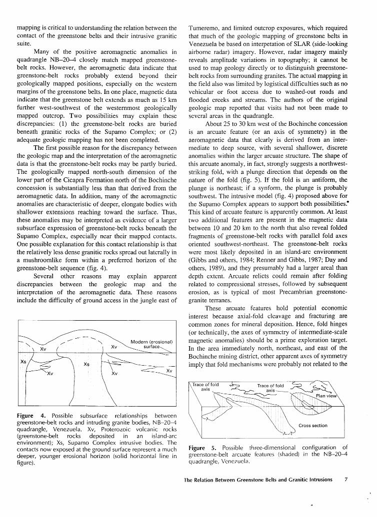
The first possible reason for the discrepancy between the geologic map and the interpretation of the aeromagnetic data is that the greenstone-belt rocks may be partly buried. The geologically mapped north-south dimension of the lower part of the Cicapra Formation north of the Bochinche concession is substantially less than that derived from the aeromagnetic data. In addition, many of the aeromagnetic anomalies are characteristic of deeper, elongate bodies with shallower extensions reaching toward the surface. Thus, these anomalies may be interpreted as evidence of a larger subsurface expression of greenstone-belt rocks beneath the Supamo Complex, especially near their mapped contacts. One possible explanation for this contact relationship is that the relatively less dense granitic rocks spread out laterally in a mushroomlike form within a preferred horizon of the greenstone-belt sequence (fig. 4).
Several other reasons may explain apparent discrepancies between the geologic map and the interpretation of the aeromagnetic data. These reasons include the difficulty of ground access in the jungle east of
Figure 4. Possible subsurface relationships between greenstone-belt rocks and intruding granite bodies, NB-20-4 quadrangle, Venezuela. Xv, Proterozoic volcanic rocks (greenstone-belt rocks deposited in an island-arc environment); Xs, Supamo Complex intrusive bodies. The contacts now exposed at the ground surface represent a much deeper, younger erosional horizon (solid horizontal line in figure).
Tumeremo, and limited outcrop exposures, which required that much of the geologic mapping of greenstone belts in Venezuela be based on interpetation of SLAR (side-looking airborne radar) imagery. However, radar imagery mainly reveals amplitude variations in topography; it cannot be used to map geology directly or to distinguish greenstonebelt rocks from surrounding granites. The actual mapping in the field also was limited by logistical difficulties such as no vehicular or foot access due to washed-out roads and flooded creeks and streams. The authors of the original geologic map reported that visits had not been made to several areas in the quadrangle.
About 25 to 30 km west of the Bochinche concession is an arcuate feature (or an axis of symmetry) in the aeromagnetic data that clearly is derived from an intermediate to deep source, with several shallower, discrete anomalies within the larger arcuate structure. The shape of this arcuate anomaly, in fact, strongly suggests a northweststriking fold, with a plunge direction that depends on the nature of the fold (fig. 5). If the fold is an antiform, the plunge is northeast; if a synform, the plunge is probably southwest. The intrusive model (fig. 4) proposed above for the Supamo Complex appears to support both possibilities.• This kind of arcuate feature is apparently common. At least two additional features are present in the magnetic data between 10 and 20 km to the north that also reveal folded fragments of greenstone-belt rocks with parallel fold axes oriented southwest-northeast. The greenstone-belt rocks were most likely deposited in an island-arc environment (Gibbs and others, 1984; Renner and Gibbs, 1987; Day and others, 1989), and they presumably had a larger areal than depth extent. Arcuate relicts could remain after folding related to compressional stresses, followed by subsequent erosion, as is typical of most Precambrian greenstonegranite terranes.
These arcuate features hold potential economic interest because axial-fold cleavage and fracturing are common zones for mineral deposition. Hence, fold hinges (or technically, the axes of symmetry of intermediate-scale magnetic anomalies) should be a prime exploration target. In the area immediately north, northeast, and east of the Bochinche mining district, other apparent axes of symmetry imply that fold mechanisms were probably not related to the
Figure 5. Possible three-dimensional configuration of greenstone-belt arcuate features (shaded) in the NB-20-4 quadrangle, Venezuela.
The Relation Between Greenstone Belts and Granitic Intrusions 7
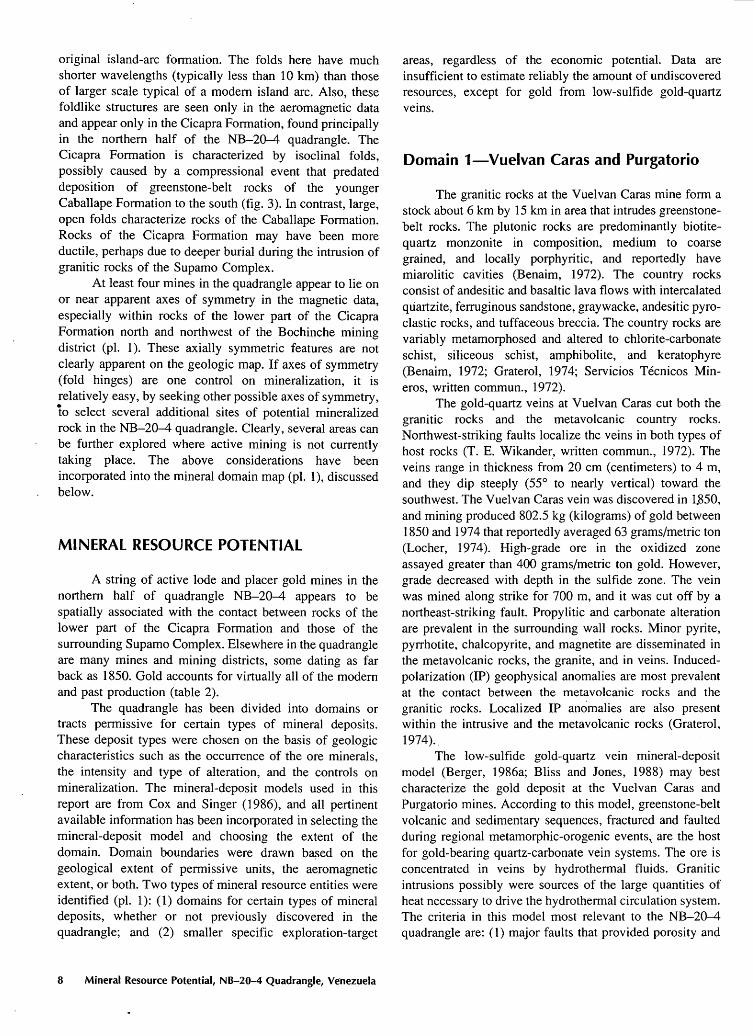
original island-arc formation. The folds here have much shorter wavelengths (typically less than I 0 km) than those of larger scale typical of a modem island arc. Also, these foldlike structures are seen only in the aeromagnetic data and appear only in the Cicapra Formation, found principally in the northern half of the NB-20-4 quadrangle. The Cicapra Formation is characterized by isoclinal folds, possibly caused by a compressional event that predated deposition of greenstone-belt rocks of the younger Caballape Formation to the south (fig. 3). In contrast, large, open folds characterize rocks of the Caballape Formation. Rocks of the Cicapra Formation may have been more ductile, perhaps due to deeper burial during the intrusion of granitic rocks of the Supamo Complex.
At least four mines in the quadrangle appear to lie on or near apparent axes of symmetry in the magnetic data, especially within rocks of the lower part of the Cicapra Formation north and northwest of the Bochinche mining district (pl. 1 ). These axially symmetric features are not clearly apparent on the geologic map. If axes of symmetry (fold hinges) are one control on mineralization, it is relatively easy, by seeking other possible axes of symmetry, to select several additional sites of potential mineralized rock in the NB-20-4 quadrangle. Clearly, several areas can be further explored where active mining is not currently taking place. The above considerations have been incorporated into the mineral domain map (pl. 1 ), discussed below.
MINERAL RESOURCE POTENTIAL
A string of active lode and placer gold mines in the northern half of quadrangle NB-20-4 appears to be spatially associated with the contact between rocks of the lower part of the Cicapra Formation and those of the surrounding Supamo Complex. Elsewhere in the quadrangle are many mines and mining districts, some dating as far back as 1850. Gold accounts for virtually all of the modem and past production (table 2).
The quadrangle has been divided into domains or tracts permissive for certain types of mineral deposits. These deposit types were chosen on the basis of geologic characteristics such as the occurrence of the ore minerals, the intensity and type of alteration, and the controls on mineralization. The mineral-deposit models used in this report are from Cox and Singer (1986), and all pertinent available information has been incorporated in selecting the mineral-deposit model and choosing the extent of the domain. Domain boundaries were drawn ba~ed on the geological extent of permissive units, the aeromagnetic extent, or both. Two types of mineral resource entities were identified (pl. 1 ): ( 1) domains for certain types of mineral deposits, whether or not previously discovered in the quadrangle; and (2) smaller specific exploration-target
8 Mineral Resource Potential, NB-20-4 Quadrangle, Venezuela
areas, regardless of the economic potential. Data are insufficient to estimate reliably the amount of undiscovered resources, except for gold from low-sulfide gold-quartz veins.
Domain 1-Vuelvan Caras and Purgatorio
The granitic rocks at the Vuelvan Caras mine form a stock about 6 km by 15 km in area that intrudes greenstonebelt rocks. The plutonic rocks are predominantly biotitequartz monzonite in composition, medium to coarse grained, and locally porphyritic, and reportedly have miarolitic cavities (Benaim, 1972). The country rocks consist of andesitic and basaltic lava flows with intercalated quartzite, ferruginous sandstone, graywacke, andesitic pyroclastic rocks, and tuffaceous breccia. The country rocks are variably metamorphosed and altered to chlorite-carbonate schist, siliceous schist, amphibolite, and keratophyre (Benaim, 1972; Graterol, 1974; Servicios Tecnicos Mineros, written commun., 1972).
The gold-quartz veins at Vuelvan Caras cut both the granitic rocks and the metavolcanic country rocks. Northwest-striking faults localize the veins in both types of host rocks (T. E. Wikander, written commun., 1972). The veins range in thickness from 20 em (centimeters) to 4 m, and they dip steeply (55° to nearly vertical) toward the southwest. The Vuelvan Caras vein was discovered in 1.850, and mining produced 802.5 kg (kilograms) of gold between 1850 and 1974 that reportedly averaged 63 grams/metric ton (Locher, 1974). High-grade ore in the oxidized zone assayed greater than 400 grams/metric ton gold. However, grade decreased with depth in the sulfide zone. The vein was mined along strike for 700 m, and it was cut off by a northeast-striking fault. Propylitic and carbonate alteration are prevalent in the surrounding wall rocks. Minor pyrite, pyrrhotite, chalcopyrite, and magnetite are disseminated in the metavolcanic rocks, the granite, and in veins. Inducedpolarization (IP) geophysical anomalies are most prevalent at the contact between the metavolcanic rocks and the granitic rocks. Localized IP anomalies are also present within the intrusive and the metavolcanic rocks (Graterol, 1974).'
The low-sulfide gold-quartz vein mineral-deposit model (Berger, 1986a; Bliss and Jones, 1988) may best characterize the gold deposit at the Vuelvan Caras and Purgatorio mines. According to this model, greenstone-belt volcanic and sedimentary sequences, fractured and faulted during regional metamorphic-orogenic events,. are the host for gold-bearing quartz-carbonate vein systems. The ore is concentrated in veins by hydrothermal fluids. Granitic intrusions possibly were sources of the large quantities of heat necessary to drive the hydrothermal circulation system. The criteria in this model most relevant to the NB-20-4 quadrangle are: ( 1) major faults that provided porosity and
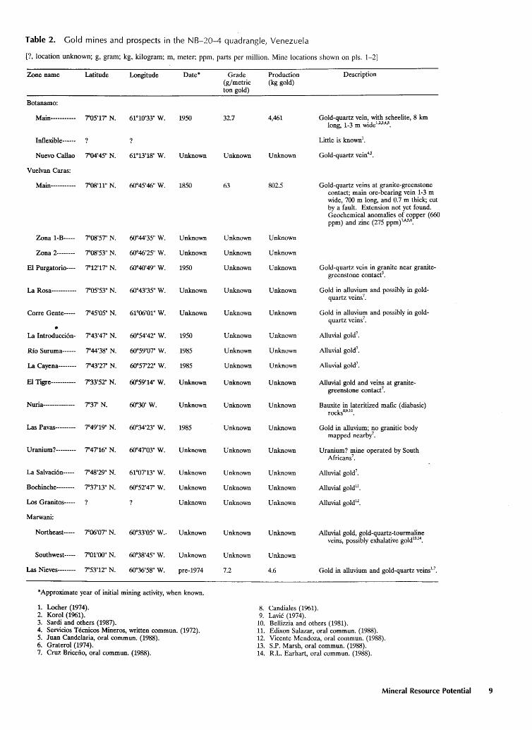
Table 2. Gold mines and prospects in the NB-20-4 quadrangle, Venezuela
[?, location unknown; g, gram; kg, kilogram; m, meter; ppm, parts per million. Mine locations shown on pis. 1-2]
Zone name Latitude Longitude Date* Grade Production Description (g/metric (kg gold) ton gold)
Botanamo:
Main----------- 'r05'17" N. 61"10'33" w. 1950 32.7 4,461 Gold-quartz vein, with scheelite, 8 km long, 1-3m wide1
'2.3'
4.s.
Inflexible------ Little is known1•
Nuevo Callao 'r04'45" N. 61°13'18" w. Unknown Unknown Unknown Gold-quartz vein4.s.
Vuelvan Caras:
Main----------- 'r08'11" N. 60°45'46" w. 1850 63 802.5 Gold-quartz veins at granite-greenstone contact; main ore-bearing vein 1-3m wide, 700 m long, and 0.7 m thick; cut by a fault. Extension not yet found. Geochemical anomalies of copper (660 ppm) and zinc (275 ppm)1
,4,s,6
•
Zona 1-B----- 'r08'57" N. 60°44'35" w. Unknown Unknown Unknown
Zona 2-------- 'r08'53" N. 60°46'25" w. Unknown Unknown Unknown
El Purgatorio---- 'r12'17" N. 60°40'49" w. 1950 Unknown Unknown Gold-quartz vein in granite near granite-greenstone contacf.
La Rosa----------- 'r05'53" N. 60°43'35" W. Unknown Unknown Unknown Gold in alluvium and possibly in gold-quartz veins7
•
Corre Gente----- 'r45'05" N. 61°06'01" w. Unknown Unknown Unknown Gold in alluvium and possibly in gold-quartz veins7
•
• La Introducci6n- 7°43'47" N. 60°54'42" w. 1950 Unknown Unknown Alluvial gold7
•
Rio Suruma------ 'r44'38" N. 60°59'07" W. 1985 Unknown Unknown Alluvial gold7•
La Cayena-------- 'r43'27" N. 6()057'22" w. 1985 Unknown Unknown Alluvial gold7•
El Tigre----------- r33'52"N. 6()059'14" w. Unknown Unknown Unknown Alluvial gold and veins at granite-greenstone contacf.
Nuria-------------- r37'N. 6()030' w. Unknown Unknown Unknown Bauxite in lateritized mafic ( diabasic) rocks8
'9
'10
•
Las Pavas--------- 'r49'19" N. 60~'23"W. 1985 Unknown Unknown Gold in alluvium; no granitic body mapped nearby7
•
Uranium?--------- 'r47'16" N. 60°47'03" w. Unknown Unknown Unknown Uranium? mine operated by South Africans7
•
La Salvaci6n----- r48'29" N. 61"07'13" w. Unknown Unknown Unknown Alluvial gold7•
Bochinche-------- 737'13" N. 60°52'47" W. Unknown Unknown Unknown Alluvial gold11•
Los Granitos----- Unknown Unknown Unknown Alluvial gold12•
Marwani:
Northeast----- 7°06'07" N. 60~3'05" w .. Unknown Unknown Unknown Alluvial gold, gold-quartz-tourmaline veins, possibly exhalative gold13
•14
•
Southwest----- roroo" N. 60~'45"W. Unknown Unknown Unknown
Las Nieves-------- r53'12" N. 60"36'58" w. pre-1974 7.2 4.6 Gold in alluvium and gold-quartz veins1·7
•
*Approximate year of initial mining activity, when known.
1. Locher (1974). 8. Candiales (1961). 2. Korol (1961). 9. Lavie (1974). 3. Sardi and others (1987). 10. Bellizzia and others (1981). 4. Servicios Tecnicos Mineros, written commun. (1972). 11. Edixon Salazar, oral commun. (1988). 5. Juan Candelaria, oral commun. (1988). 12. Vicente Mendoza, oral commun. (1988). 6. Graterol (1974). 13. S.P. Marsh, oral commun. (1988). 7. Cruz Briceno, oral commun. (1988). 14. R.L. Earhart, oral commun. (1988).
Mineral Resource Potential 9
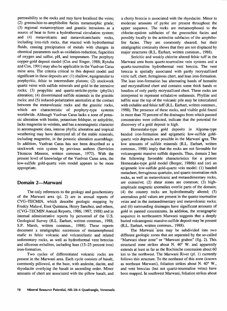
permeability to the rocks and may have localized the veins; (2) greenschist-to-amphibolite facies metamorphic grade; (3) regional metamorphism and granitic intrusions as a source of heat to form a hydrothermal circulation system; and (4) metavolcanic and metavolcaniclastic rocks, including iron-rich rocks, that reacted with hydrothermal fluids, causing precipitation of metals with changes in chemical parameters such as oxidation-reduction, fugacities of oxygen and sulfur, pH, and temperature. The porphyry copper-gold deposit model (Cox and Singer, 1988; Rytuba and Cox, 1991) may also be applicable in the Vuelvan Caras mine area. The criteria critical to this deposit model and significant in these deposits are: ( 1) shallow, equigranular to porphyritic, felsic to intermediate plutons; (2) stockwork quartz veins with sulfide minerals and gold in the intrusive rocks; (3) propylitic and quartz-sericite-pyrite (phyllic) alteration; (4) disseminated sulfide minerals in the granitic rocks; and (5) induced-polarization anomalies at the contact between the metavolcanic rocks and the granitic rocks, which are characteristic of porphyry-type systems worldwide. Although Vuelvan Caras lacks a zone of potassic alteration with biotite, potassium feldspar, or anhydrite, lacks magnetite in veinlets, and has a nonmagnetic character in aeromagnetic data, intense phyllic alteration and tropical weathering may have destroyed all of the stable minerals, including magnetite, in the potassic alteration assemblage. In addition, Vuelvan Caras has not been described as a stockwork vein system by previous authors (Servicios Tecnicos Mineros, written commun., 1972). With the present level of knowledge of the Vuelvan Caras area, the low-sulfide gold-quartz vein model appears to be more appropriate.
Domain 2-Marwani
The only references to the geology and geochemistry of the Marwani area (pl. 2) are in annual reports of CVG-TECMIN, which describe geologic mapping by Freddy Malave, Enot Quintana, Henry Sanchez, and others, (CVG-TECMIN Annual Reports, 1986; 1987; 1988) and in internal administrative reports by personnel of the U.S. Geological Survey (R.L. Earhart, written commun., 1988; S.P. Marsh, written commun., 1988). These reports document a stratigraphic succession of metamorphosed mafic to felsic volcanic and volcaniclastic and related sedimentary rocks, as well as hydrothermal vent breccias and siliceous exhalites, including lean (15-25 percent iron) iron-formation.
Two cycles of differentiated volcanic rocks are present in the Marwani area. Each cycle consists of basalt, commonly pillowed, at the base, with andesite, dacite, and rhyodacite overlying the basalt in ascending order. Minor amounts of chert are associated with the pillow basalt, and
10 Mineral Resource Potential, NB-20-4 Quadrangle, Venezuela
a cherty breccia is associated with the rhyodacite. Minor to moderate amounts of pyrite are present throughout the upper sequence. The rocks are metamorphosed to the chlorite-epidote subfacies of the greenschist facies and possibly locally to the actinolite subfacies of the amphibolite facies. They are commonly sheared, but their stratigraphic continuity shows that they are not displaced by major structures (R.L. Earhart, written commun., 1988).
Sericitic and weakly chlorite altered felsic tuff in the Marwani area hosts quartz-tourmaline vein systems and a quartz-tourmaline hydrothermal vent breccia. The vent breccia is spatially associated with partly recrystallized vitric tuff, chert, ferruginous chert, and lean iron-formation. The lean iron-formation has alternating bands of hematite and recrystallized chert and contains some thick bands or boudins of only partly recrystallized chert. These rocks are interpreted to represent exhalative sediments. Phyllite and tuffite near the top of the volcanic pile may be intercalated with exhalite and felsic tuff (R.L. Earhart, written commun., 1988). The presence of these rocks, and visible gold found in more than 70 percent of the drainages from which panned concentrates were collected, indicate that the potential for discovery of a gold deposit is high.
Homestake-type gold deposits in Algoma-type banded iron-formation and epigenetic low-sulfide goldquartz vein deposits are possible in the Marwani ¥ea. The low amounts of sulfide minerals (R.L. Earhart, written commun., 1988) imply that the rocks are not favorable for volcanogenic massive sulfide deposits. Thus, domain 2 has the following favorable characteristics for a protore Homestake-type gold model (Berger; 1986b) and (or) an epigenetic low-sulfide gold-quartz vein model: (1) banded metachert, ferruginous quartzite, and quartz-tourmaline-rich rocks, as well as metavolcanic and metasedimentary rocks, are extensive; (2) shear zones are common; (3) highamplitude magnetic anomalies overlie parts of the domain; (4) the country rocks are hydrothermally altered; (5) anomalous gold values are present in the quartz-tourmaline veins and in the metasedimentary and metavolcanic rocks; and ( 6) surrounding drainages have significant amounts of gold in panned concentrates. In addition, the stratigraphic sequence in northeastern Marwani suggests that a deeply buried volcanogenic massive-sulfide deposit may be present (R.L. Earhart, written commun., 1988).
The Marwani "area may be subdivided into two different geologic zones that are separated by the so-called "Marwani shear zone" or "Marwani graben" (fig. 2). This structural zone strikes about N. 40° W. and apparently extends at least as far as the Bochinche concession about 60 km to the northwest. The Marwani River (pl. 1) currently follows this structure. To the northeast of this zone (known as northeast Marwani), foliation strikes about N. 40° W., and vent breccias (but not quartz-tourmaline veins) have been mapped. In southwest Marwani, foliation strikes about
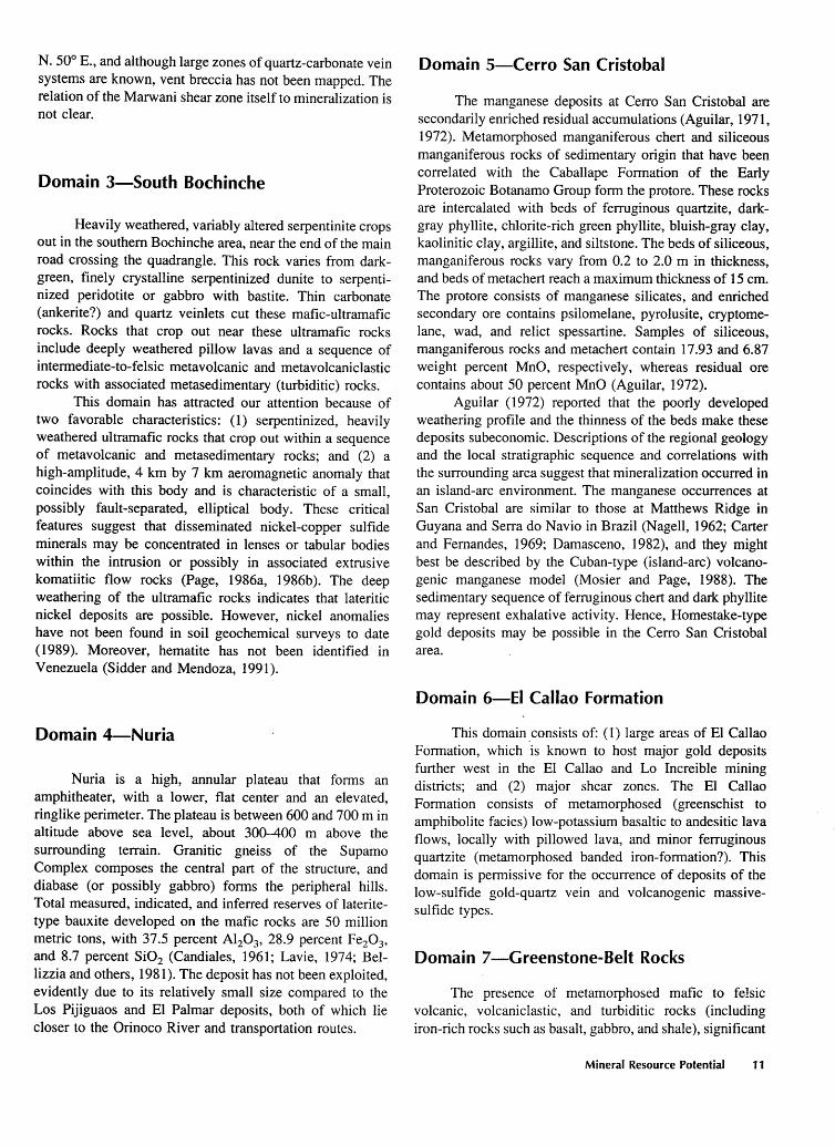
N. 50° E., and although large zones of quartz-carbonate vein systems are known, vent breccia has not been mapped. The relation of the Marwani shear zone itself to mineralization is not clear.
Domain 3-South Bochinche
Heavily weathered, variably altered serpentinite crops out in the southern Bochinche area, near the end of the main road crossing the quadrangle. This rock varies from darkgreen, finely crystalline serpentinized dunite to serpentinized peridotite or gabbro with bastite. Thin carbonate (ankerite?) and quartz veinlets cut these mafic-ultramafic rocks. Rocks that crop out near these ultramafic rocks include deeply weathered pillow lavas and a sequence of intermediate-to-felsic metavolcanic and metavolcaniclastic rocks with associated metasedimentary (turbiditic) rocks.
This domain has attracted our attention because of two favorable characteristics: (1) serpentinized, heavily weathered ultramafic rocks that crop out within a sequence of metavolcanic and metasedimentary rocks; and (2) a high-amplitude, 4 km by 7 km aeromagnetic anomaly that coincides with this body and is characteristic of a small, possibly fault-separated, elliptical body. These critical features suggest that disseminated nickel-copper sulfide minerals may be concentrated in lenses or tabular bodies within the intrusion or possibly in associated extrusive komatiitic flow rocks (Page, 1986a, 1986b ). The deep weathering of the ultramafic rocks indicates that lateritic nickel deposits are possible. However, nickel anomalies have not been found in soil geochemical surveys to date (1989). Moreover, hematite has not been identified in Venezuela (Sidder and Mendoza, 1991).
Domain 4-Nuria
Nuria is a high, annular plateau that forms an amphitheater, with a lower, flat center and an elevated, ringlike perimeter. The plateau is between 600 and 700 m in altitude above sea level, about 300-400 m above the surrounding terrain. Granitic gneiss of the Supamo Complex composes the central part of the structure, and diabase (or possibly gabbro) forms the peripheral hills. Total measured, indicated, and inferred reserves of lateritetype bauxite developed on the mafic rocks are 50 million metric tons, with 37.5 percent Al20 3, 28.9 percent Fe20 3,
and 8.7 percent Si02 (Candiales, 1961; Lavie, 1974; Bellizzia and others, 1981). The deposit has not been exploited, evidently due to its relatively small size compared to the Los Pijiguaos and El Palmar deposits, both of which lie closer to the Orinoco River and transportation routes.
Domain 5-Cerro San Cristobal
The manganese deposits at Cerro San Cristobal are secondarily enriched residual accumulations (Aguilar, 1971, 1972). Metamorphosed manganiferous chert and siliceous manganiferous rocks of sedimentary origin that have been correlated with the Caballape Formation of the Early Proterozoic Botanamo Group form the protore. These rocks are intercalated with beds of ferruginous quartzite, darkgray phyllite, chlorite-rich green phyllite, bluish-gray clay, kaolinitic clay, argillite, and siltstone. The beds of siliceous, manganiferous rocks vary from 0.2 to 2.0 m in thickness, and beds of metachert reach a maximum thickness of 15 em. The protore consists of manganese silicates, and enriched secondary ore contains psilomelane, pyrolusite, cryptomelane, wad, and relict spessartine. Samples of siliceous, manganiferous rocks and metachert contain 17.93 and 6.87 weight percent MnO, respectively, whereas residual ore contains about 50 percent MnO (Aguilar, 1972).
Aguilar (1972) reported that the poorly developed weathering profile and the thinness of the beds make these deposits subeconomic. Descriptions of the regional geology and the local stratigraphic sequence and correlations with the surrounding area suggest that mineralization occurred in an island-arc environment. The manganese occurrences at San Cristobal are similar to those at Matthews Ridge in Guyana and Serra do Navio in Brazil (Nagell, 1962; Carter and Fernandes, 1969; Damasceno, 1982), and they might best be described by the Cuban-type (island-arc) volcanogenic manganese model (Mosier and Page, 1988). The sedimentary sequence of ferruginous chert and dark phyllite may represent exhalative activity. Hence, Homestake-type gold deposits may be possible in the Cerro San Cristobal area.
Domain 6-EI Callao Formation
This domain _consists of: (1) large areas of El Callao Formation, which is known to host major gold deposits further west in the El Callao and Lo Increible mining districts; and (2) major shear zones. The El Callao Formation consists of metamorphosed (greenschist to amphibolite facies) low-potassium basaltic to andesitic lava flows, locally with pillowed lava, and minor ferruginous quartzite (metamorphosed banded iron-formation?). This domain is permissive for the occurrence of deposits of the low-sulfide gold-quartz vein and volcanogenic massivesulfide types.
Domain ?-Greenstone-Belt Rocks
The presence of metamorphosed mafic to felsic volcanic, volcaniclastic, and turbiditic rocks (including iron-rich rocks such as basalt, gabbro, and shale), significant
Mineral Resource Potential 11
faulting and shearing, and gold-quartz-tourmaline vein systems make this domain permissive for low-sulfide goldquartz veins and possibly volcanogenic massive-sulfide deposits (kuroko-type). However, massive-sulfide deposits have not been identified anywhere in the Guayana Shield, nor have base-metal sulfide minerals been recognized in the metavolcanic or metasedimentary rocks. A few geochemical anomalies of copper, lead, and zinc in soil have been located by CVG-TECMIN in the Bochinche and Marwani areas. However, the anomalies are related to the gold-bearing quartz veins and are not representative of massive sulfide deposits (S.P. Marsh, oral commun., 1989). The lack of known massive-sulfide occurrences may be due to the deep tropical weathering and also to the lack of systematic exploration programs for this kind of deposit.
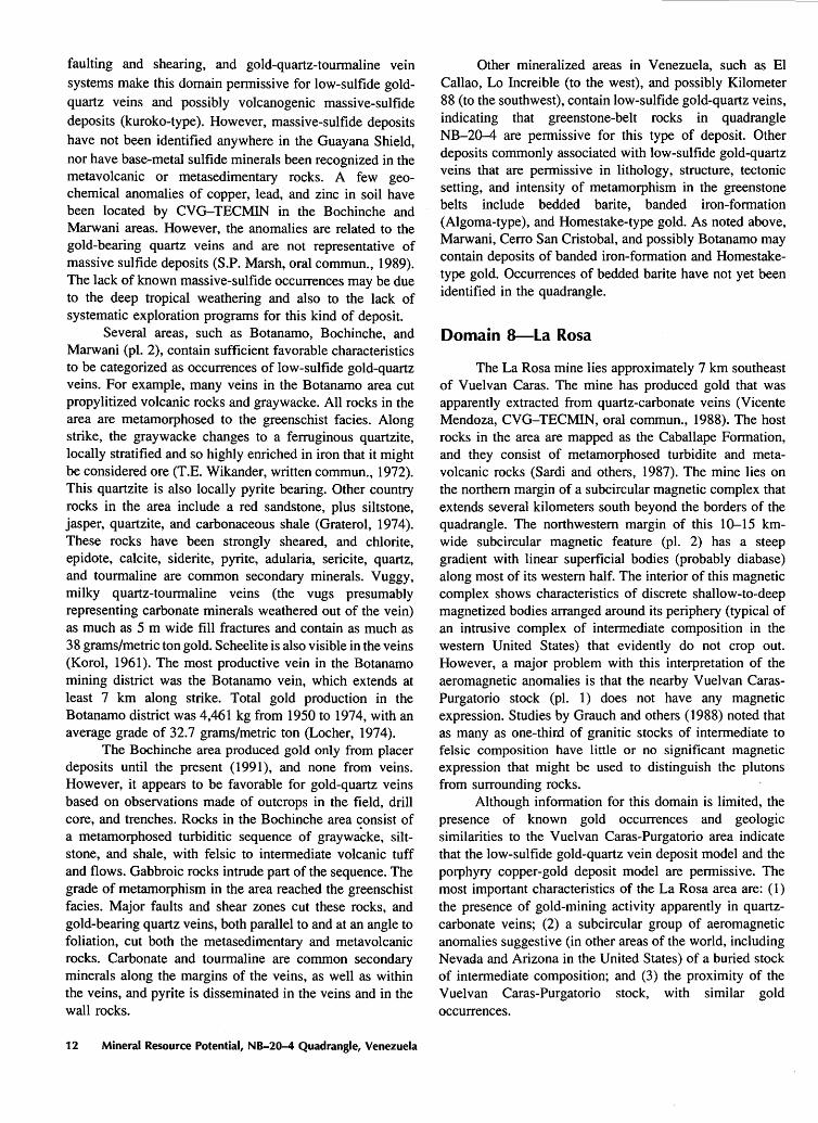
Several areas, such as Botanamo, Bochinche, and Marwani (pl. 2), contain sufficient favorable characteristics to be categorized as occurrences of low-sulfide gold-quartz veins. For example, many veins in the Botanamo area cut propylitized volcanic rocks and graywacke. All rocks in the area are metamorphosed to the greenschist facies. Along strike, the graywacke changes to a ferruginous quartzite, locally stratified and so highly enriched in iron that it might be considered ore (T.E. Wikander, written commun., 1972). This quartzite is also locally pyrite bearing. Other country rocks in the area include a red sandstone, plus siltstone, jasper, quartzite, and carbonaceous shale (Graterol, 1974). These rocks have been strongly sheared, and chlorite, epidote, calcite, siderite, pyrite, adularia, sericite, quartz, and tourmaline are common secondary minerals. Vuggy, milky quartz-tourmaline veins (the vugs presumably representing carbonate minerals weathered out of the vein) as much as 5 m wide fill fractures and contain as much as 38 grams/metric ton gold. Scheelite is also visible in the veins (Korol, 1961). The most productive vein in the Botanamo mining district was the Botanamo vein, which extends at least 7 km along strike. Total gold production in the Botanamo district was 4,461 kg from 1950 to 1974, with an average grade of 32.7 grams/metric ton (Locher, 1974).
The Bochinche area produced gold only from placer deposits until the present ( 1991 ), and none from veins. However, it appears to be favorable for gold-quartz veins based on observations made of outcrops in the field, drill core, and trenches. Rocks in the Bochinche area consist of a metamorphosed turbiditic sequence of graywacke, siltstone, and shale, with felsic to intermediate volcanic tuff and flows. Gabbroic rocks intrude part of the sequence. The grade of metamorphism in the area reached the greenschist facies. Major faults and shear zones cut these rocks, and gold-bearing quartz veins, both parallel to and at an angle to foliation, cut both the metasedimentary and metavolcanic rocks. Carbonate and tourmaline are common secondary minerals along the margins of the veins, as well as within the veins, and pyrite is disseminated in the veins and in the wall rocks.
12 Mineral Resource Potential, NB-20-4 Quadrangle, Venezuela
Other mineralized areas in Venezuela, such as El Callao, Lo Increible (to the west), and possibly Kilometer 88 (to the southwest), contain low-sulfide gold-quartz veins, indicating that greenstone-belt rocks in quadrangle NB-20--4 are permissive for this type of deposit. Other deposits commonly associated with low-sulfide gold-quartz veins that are permissive in lithology, structure, tectonic setting, and intensity of metamorphism in the greenstone belts include bedded barite, banded iron-formation (Algoma-type), and Homestake-type gold. As noted above, Marwani, Cerro San Cristobal, and possibly Botanamo may contain deposits of banded iron-formation and Homestaketype gold. Occurrences of bedded barite have not yet been identified in the quadrangle.
Domain 8-La Rosa
The La Rosa mine lies approximately 7 km southeast of Vuelvan Caras. The mine has produced gold that was apparently extracted from quartz-carbonate veins (Vicente Mendoza, CVG-TECMIN, oral commun., 1988). The host rocks in the area are mapped as the Caballape Formation, and they consist of metamorphosed turbidite and metavolcanic rocks (Sardi and others, 1987). The mine lies on the northern margin of a subcircular magnetic complex that extends several kilometers south beyond the borders of the quadrangle. The northwestern margin of this 10-15 kmwide subcircular magnetic feature (pl. 2) has a steep gradient with linear superficial bodies (probably diabase) along most of its western half. The interior of this magnetic complex shows characteristics of discrete shallow-to-deep magnetized bodies arranged around its periphery (typical of an intrusive complex of intermediate composition in the western United States) that evidently do not crop out. However, a major problem with this interpretation of the aeromagnetic anomalies is that the nearby Vuelvan CarasPurgatorio stock (pl. 1) does not have any magnetic expression. Studies by Grauch and others (1988) noted that as many as one-third of granitic stocks of intermediate to felsic composition have little or no significant magnetic expression that might be used to distinguish the plutons from surrounding rocks.
Although information for this domain is limited, the presence of known gold occurrences and geologic similarities to the Vuelvan Caras-Purgatorio area indicate that the low-sulfide gold-quartz vein deposit model and the porphyry copper-gold deposit model are permissive. The most important characteristics of the La Rosa area are: ( 1) the presence of gold-mining activity apparently in quartzcarbonate veins; (2) a subcircular group of aeromagnetic anomalies suggestive (in other areas of the world, including Nevada and Arizona in the United States) of a buried stock of intermediate composition; and (3) the proximity of the Vuelvan Caras-Purgatorio stock, with similar gold occurrences.
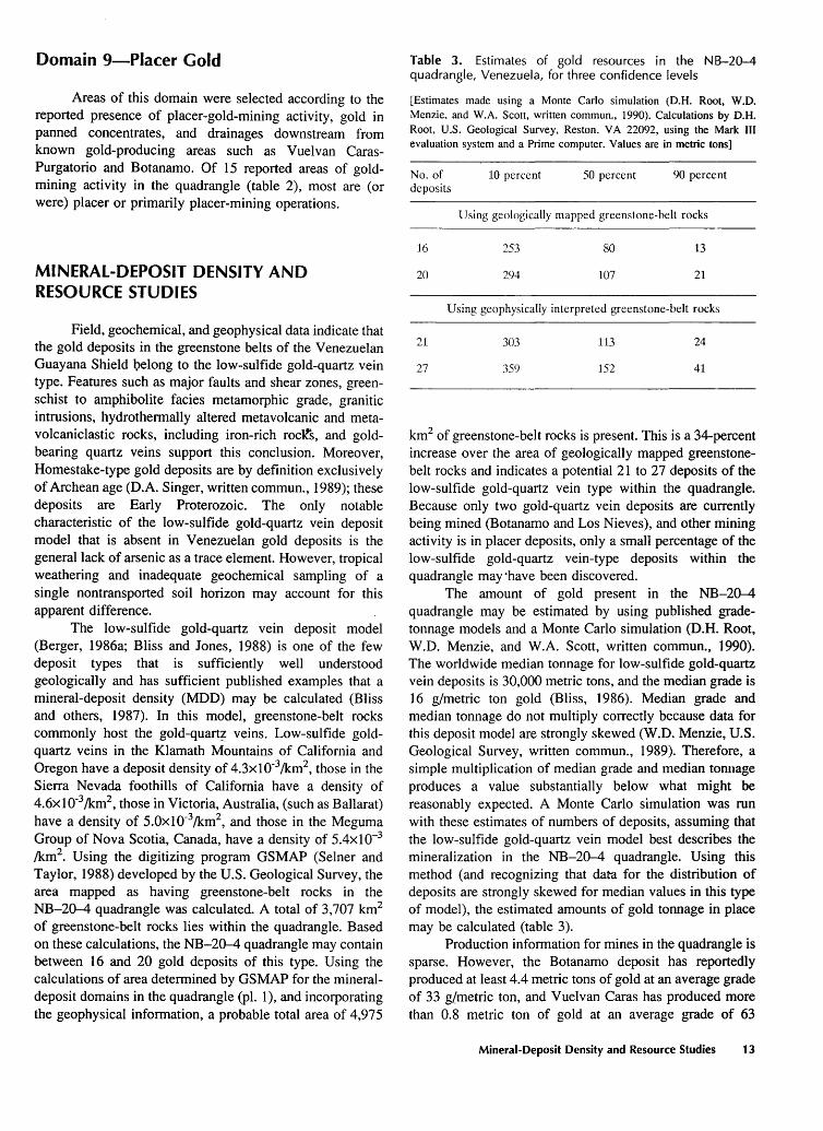
Domain 9-Piacer Gold
Areas of this domain were selected according to the reported presence of placer-gold-mining activity, gold in panned concentrates, and drainages downstream from known gold-producing areas such as Vuelvan CarasPurgatorio and Botanamo. Of 15 reported areas of goldmining activity in the quadrangle (table 2), most are (or were) placer or primarily placer-mining operations.
MINERAL-DEPOSIT DENSITY AND RESOURCE STUDIES
Field, geochemical, and geophysical data indicate that the gold deposits in the greenstone belts of the Venezuelan Guayana Shield ]?elong to the low-sulfide gold-quartz vein type. Features such as major faults and shear zones, greenschist to amphibolite facies metamorphic grade, granitic intrusions, hydrothermally altered metavolcanic and metavolcaniclastic rocks, including iron-rich roclts, and goldbearing quartz veins support this conclusion. Moreover, Homestake-type gold deposits are by definition exclusively of Archean age (D.A. Singer, written commun., 1989); these deposits are Early Proterozoic. The only notable characteristic of the low-sulfide gold-quartz vein deposit model that is absent in Venezuelan gold deposits is the general lack of arsenic as a trace element. However, tropical weathering and inadequate geochemical sampling of a single nontransported soil horizon may account for this apparent difference.
The low-sulfide gold-quartz vein deposit model (Berger, 1986a; Bliss and Jones, 1988) is one of the few deposit types that is sufficiently well understood geologically and has sufficient published examples that a mineral-deposit density (MDD) may be calculated (Bliss and others, 1987). In this model, greenstone-belt rocks commonly host the gold-quart~ veins. Low-sulfide goldquartz veins in the Klamath Mountains of California and Oregon have a deposit density of 4.3x10⁻³!km2
, those in the Sierra Nevada foothills of California have a density of 4.6x10⁻³/km2
, those in Victoria, Australia, (such as Ballarat) have a density of 5.0x10⁻³/km2
, and those in the Meguma Group of Nova Scotia, Canada, have a density of 5.4x10⁻³
/km2• Using the digitizing program GSMAP (Selner and
Taylor, 1988) developed by the U.S. Geological Survey, the area mapped as having greenstone-belt rocks in the NB-20-4 quadrangle was calculated. A total of 3, 707 km2
of greenstone-belt rocks lies within the quadrangle. Based on these calculations, the NB-20-4 quadrangle may contain between 16 and 20 gold deposits of this type. Using the calculations of area determined by GSMAP for the mineraldeposit domains in the quadrangle (pl. 1), and incorporating the geophysical information, a probable total area of 4,97 5
Table 3. Estimates of gold resources in the NB-20-4 quadrangle, Venezuela, for three confidence levels
[Estimates made using a Monte Carlo simulation (D.H. Root, W.O. Menzie, and W.A. Scott, written commun., 1990). Calculations by D.H. Root, U.S. Geological Survey, Reston, VA 22092, using the Mark III evaluation system and a Prime computer. Values are in metric tons]
No. of deposits
16
20
10 percent 50 percent 90 percent
Using geologically mapped greenstone-belt rocks
253 80 13
294 107 21
Using geophysically interpreted greenstone-belt rocks
21 303 113 24
27 359 152 41
km2 of greenstone-belt rocks is present. This is a 34-percent increase over the area of geologically mapped greenstonebelt rocks and indicates a potential 21 to 27 deposits of the low-sulfide gold-quartz vein type within the quadrangle. Because only two gold-quartz vein deposits are currently being mined (Botanamo and Los Nieves), and other mining activity is in placer deposits, only a small percentage of the low-sulfide gold-quartz vein-type deposits within the quadrangle may ·have been discovered.
The amount of gold present in the NB-20-4 quadrangle may be estimated by using published gradetonnage models and a Monte Carlo simulation (D.H. Root, W.D. Menzie, and W.A. Scott, written commun., 1990). The worldwide median tonnage for low-sulfide gold-quartz vein deposits is 30,000 metric tons, and the median grade is 16 g/metric ton gold (Bliss, 1986). Median grade and median tonnage do not multiply correctly because data for this deposit model are strongly skewed (W.D. Menzie, U.S. Geological Survey, written commun., 1989). Therefore, a simple multiplication of median grade and median tonnage produces a value substantially below what might be reasonably expected. A Monte Carlo simulation was run with these estimates of numbers of deposits, assuming that the low-sulfide gold-quartz vein model best describes the mineralization in the NB-20-4 quadrangle. Using this method (and recognizing that data for the distribution of deposits are strongly skewed for median values in this type of model), the estimated amounts of gold tonnage in place may be calculated (table 3).
Production information for mines in the quadrangle is sparse. However, the Botanamo deposit has reportedly produced at least 4.4 metric tons of gold at an average grade of 33 g/metric ton, and Vuelvan Caras has produced more than 0.8 metric ton of gold at an average grade of 63
Mineral-Deposit Density and Resource Studies 13
grams/metric ton (Locher, 1974). Both of these deposits may be characterized as having low-sulfide gold-quartz vein types. Hence, possibly 14 to 25 deposits still remain to be discovered, and a total of at least 19 metric tons of gold (using the 90-percent confidence level from the geophysically interpreted data, table 3) remain within the quadrangle. The most conservative estimate, that more than 8 metric tons of gold still remain to be discovered in the quadrangle, suggests strongly that further exploration in the quadrangle is warranted.
SUMMARY AND CONCLUSIONS
Early Proterozoic rocks typical of greenstone-granite terranes crop out in eastern Venezuela. Domains permissive for specific mineral deposits within these terranes have been identified in the NB-20-4 quadrangle. Mineral-deposit types possible include: (1) low-sulfide gold-quartz veins; (2) placer gold with platinum-group eleme11ts; (3) dunitic nickel-copper; (4) kuroko-type massive sulfide; (5) lateritetype bauxite; (6) secondarily enriched volcanogenic manganese; and possibly (7) Homestake-type gold. One model, low-sulfide gold-quartz veins, is sufficiently well known worldwide to permit a quantitative estimate of the number of undiscovered deposits in the NB-20-4 quadrangle. Between 16 and 27 low-sulfide gold-quartz vein-type deposits may be present within the quadrangle, based on a model of mineral-deposit density within a given area of greenstone-belt rocks in similar geologic environments around the world. Clearly, the number of placer-gold deposits is also intimately connected to the number of lode deposits, but partly because of the complex interrelationship, a mineral-deposit density is not as easily quantifiable for placer gold.
Aeromagnetic data were analyzed using forwardmodel calculations to understand the magnetic anomalies in a shallow-inclination field. Estimates of the shapes and depths of most of the discrete source bodies were made, and different magnetic terranes were outlined. Positive aeromagnetic anomalies throughout the NB-20-4 quadrangle coincide closely with mapped greenstone-belt rocks and show probable extensions of greenstone-belt rocks beyond where they are shown on the geologic map, especially on the western margins of mapped greenstone belts. The aeromagnetic data suggest the possibility of more than 30 percent additional greenstone-belt rocks in the quadrangle at the surface or in the shallow subsurface than are mapped geologically. The aeromagnetic data also indicate that, at least in the lower part of the Cicapra Formation, there are axes of symmetry not apparent on the geologic map. Many mines are associated with these probable fold structures, and additional similar structures not known to host mining activity are potential targets for exploration.
This study is the first in a series by the U.S. Geological Survey to assess the mineral resources of the
14 Mineral Resource Potential, NB-20-4 Quadrangle, Venezuela
Venezuelan Guayana Shield. Methods and techniques used in this study are immediately applicable to adjacent 1° by l 1/2° quadrangles, and even to the Guyana side of the frontier. The compilation of geologic, geophysical, geochemical, and structural data is continuing throughout the shield, and subsequent mineral resource assessments are in progress as part of the U.S. Geological Survey-CVG TECMIN cooperative project.
REFERENCES CITED
Aguilar R., Alfonso, 1971, Estudio pre! iminar de los yacimientos manganesiferos del Cerro San Cristobal, cuenca norte del Rio Botanamo, Estado Bolivar '[abs.]: IV Congreso Geologico Venezolano, Caracas 1971, Memoria, Publicacion Especial 5, v.1, p. 180.
___ 1972, Estudio preliminar de los yacimientos manganesiferos del Cerro San Cristobal, region cuenca norte del Rfo Botanamo: IV Congreso Geologico Venezolano, Caracas 1971, Memoria, Publicacion Especial5, v. 4, p. 2489-2497.
Ally, Liaquat, 1985, Volcanogenic massive sulphide potential in northern Guyana: I Simposium Amazonico, Caracas 1981, Publica1:ion Especial 10, p. 431-442.
Barron, C.N., 1969, Notes on the stratigraphy of Guyana: Seventh Guiana Geological Conference, Paramaribo, 1966, Proceedings, Records, Geological Survey of Guyana, v. 6, Paper 11-1, p. 1-28.
___ 1975, Notes on the geology of Guyana along the frontier with Venezuela: Anais da Decima Conferencia Geologica lnterguianas, Belem, Brazil, 1975, p. 219-240.
Bellizzia G., Alirio, Pimentel de Bellizzia, Nelly, and Rodriguez, Simon, 1981, Recursos minerales de Venezuela y su relacion a Ia metalogenesis: Ministerio de Energfa y Minas, Publicacion Especial 8, p. 6-77.
Benaim, Nesin, 1972, Geologia de la region de Botanamo, Edo. Bolivar: IV Congreso Geologico Venezolano, Caracas 1971, Memoria, Publicacion Especial5, v. 3, p. 1291-1314.
___ 1974, Geologia de la reg1on El Dorado-Anacoco-Botanamo, Estado Bolivar: Novena Conferencia Geologica Inter-Guayanas, Ciudad Guayana, Venezuela, 1972, Memoria, Publicacion Especial 6, p. 198-206.
Berger, B.R., 1986a, Descriptive model of low-sulfide Au-quartz veins, in Cox, D.P., and Singer, D.A., eds., Mineral deposit models: U.S. Geological Survey Bulletin 1693, p. 239.
___ 1986b, Descriptive model of Homestake Au, in Cox, D.P., and Singer, D.A., eds., Mineral deposit models: U.S. Geological Survey Bulletin 1693, p. 244.
Berrange, J.P., 1977, The geology of southern Guyana, South America: London Institute of Geological Sciences, Overseas Division Memoir, v. 4, 112 p.
Bliss, J.D., 1986, Grade and tonnage model of low-sulfide Auquartz veins, in Cox, D.P., and Singer, D.A., eds., Mineral deposit models: U.S. Geological Survey Bulletin 1693, p. 239-243.
Bliss, J.D., and Jones, G.M., 1988, Mineralogical and gradetonnage information on low-sulfide Au-quartz veins: U.S. Geological Survey Open-File Report 88-229, 99 p·.
Bliss, J.D., Menzie, W.O., Orris, G.J., and Page, N.J, 1987, Mineral deposit density-A useful tool for mineral-resource
assessment, in Sachs, J.S., ed., U.S. Geological Survey research on mineral resources-1987 program and abstracts: U.S. Geological Survey Circular 995, p. 6.
Briceno, Cruz, and Salazar, Edixon, 1987, Mapa de geologia, hoja de radar NB-20-4: Corporacion Venezolana de GuayanaTecnica Minera, C.A., 1987 annual report, map with geologic-unit descriptions, scale 1 :500,000.
Candiales, L.J., 1·961, Descubrimiento y exploracion de bauxita en Venezuela: III Congreso Geologico Venezolano, Caracas 1959, Memoria, v. 4, p. 1661-1680.
Carter, J.W., and Fernandes, L.L., 1969, The stratigraphical, lithological and structural controls to mineralization within the Barama-Mazaruni Assemblage: Geological Survey of Guyana, Records, v. 6, Paper XII-I, p. XII-1-XII-222.
Cordell, L.E., and McCafferty, A.E., 1989, A terracing operator for physical property mapping with potential field data: Geophysics, v. 54, p. 621-634.
Cox, D.P., Barton, P.B., and Singer, D.A., 1986, Introduction, in Cox, D.P., and Singer, D.A., eds., Mineral deposit models: U.S. Geological Survey Bulletin 1693, p. 1-10.
Cox, D.P., and Singer, D.A., eds., 1986, Mineral deposit models: U.S. Geological Survey Bulletin 1693, 379 p.
___ 1988, Distribution of gold in porphyry copper deposits:
U.S. Geological Survey Open-File Report 88-46, 10 p. Damasceno, E.C., 1982, Archean and Early Proterozoic mineral
deposits in Brazil: Revista Brasileira de Geociencias, International Symposium on Archean and Early Proterozoic Geologic Evolution and Metallogenesis, Salvador, Brazil, 1982, v. 12, nos. 1-3, p. 426-436.
Day, W.C., FrancoM., Luis, and Quintana, Enot, 1989, Bedrock geology and geochemistry of the Anacoco Sur II area, Bolfvar State, Venezuela: U.S. Geological Survey OpenFile Report 89-305, 14 p.
Gaudette, H.E., Hurley, P.M., Fairbairn, H.W., Espejo, Anibal, and Dahlberg, E.H., 1978, Older Guiana basement south of the Imataca Complex in Venezuela, Geological Society of America p. 1290-1294.
and in Suriname: Bulletin, v. 89,
Gibbs, A.K., 1986, Contrasting styles of continental mafic intrusions in the Guiana Shield, in Halls, H.C., and Fahrig, W.F., eds., Mafic dyke swarms: Geological Association of Canada Special Paper 34, p. 457-465.
Gibbs, A.K., and Barron, C.N., 1983, The Guiana Shield reviewed: Episodes, v. 1983, no. 2, p. 7-14.
Gibbs, A.K., O'Day, P.A., and Renner, Rebecca, 1984, Recent work on the Barama-Mazaruni Supergroup of Guyana: II Symposium Amazonico, Ministerio das Minas e Energia, Departamento Nacional da Produc;ao Mineral, Manaus, Brazil, 1984, Anais, p. 39-52.
Gibbs, A.K., and Olszewski, W.J., Jr., 1982, Zircon U-Pb ages of Guyana greenstone-gneiss terrane: Precambrian Research, V. 17, p. 199-214.
Gibbs, A.K., and Wirth, K.R., 1986, Origin and evolution of the Amazonian Craton, in Ashwal, L.D., ed., Workshop on early crustal genesis; world's oldest rocks: Godthab, Greenland, Lunar and Planetary Institute Technical Report, 1985, v. 86-04, p. 46-50.
Graterol, Victor, 1974, Resultados de Ia prospeccion geoffsica en las zonas de Vuelvan Caras y Botanamo, Edo. Bolivar: Novena Conferencia Geologica Inter-Guayanas, Ciudad Guayana, Venezuela, 1972, Memoria, Publicacion Especial 6, p. 529-549.
Grauch, V.J.S., Blakely, R.J., Blank, H.R., Jr., Oliver, H.W., Plouff, Donald, and Ponce, D.A., 1988, Geophysical delineation of granitic plutons in Nevada: U.S. Geological Survey Open-File Report 88-11, 7 p., 2 maps.
Korol, Bohdan, 1961, Minerales de tungsteno de las Minas Botanamo y El Callao: III Congreso Geologico Venezolano, Caracas 1959, Memoria, v. 4, p. 1889-1895.
Lavie, H.J., 1974, Evaluacion sistematica de las lateritas aluminosas en Ia altiplanicie de Nuria: Novena Conferencia Geologica Inter-Guayanas, Ciudad Guayana, Venezuela, 1972, Memoria, Publicacion Especial 6, p. 550-554.
Locher, Eugenio, 1974, Oro en Venezuela: Novena Conferencia Geologica Inter-Guayanas, Ciudad Guayana, Venezuela, 1972, Memoria, Publicacion Especial 6, p. 558-587.
Mendoza, Vicente, 1977, Evolucion tectonica del Escudo de Guayana: Segundo Congreso Latinoamericano de Geologia, Caracas 1973, Memoria, Publicacion Especial 7, v. 3, p. 2237-2270.
Menendez, Alfredo, 1968, Revision de Ia estratigraffa de Ia Provincia de Pastora, segun el estudio de Ia region de Guasipati, Guayana Venezolana: Caracas, Boletin de Geologia, v. 10, p. 309-338.
___ 1972, Geologia de Ia region Guasapati, Guayana Venezolana: IV Congreso Geologico Venezolano, Caracas 1971, V. 4, p. 2001-2046.
___ 1974, Petrologia y tectonica de Ia region de El Callao y su relacion con Ia mineralizacion del oro: Novena Conferencia Geologica Inter-Guayanas, Ciudad Guayana, Venezuela, 1972, Memoria, Publicacion Especial 6, p. 606.
Moreno, Luis, Lira, Pedro, Mendoza, Vicente, and Rios, J.H., 1977, Ami! isis de edades radiometricas en Ia parte oriental de Ia Guayana Venezolana y eventos tectonicos-termales registrados: V Congreso Geologico Venezolano, Caracas 1977, Memoria, v. 2, p. 509-518.
Mosier, D.L., and Page, N.J, 1988, Descriptive and grade-tonnage models of volcanogenic manganese deposits in oceanic environments-A modification: U.S. Geological Survey Bulletin 1811, 28 p.
Nagell, R.H., 1962, Geology of the Serra do Navio manganese district, Brazil: Economic Geology, v. 57, p. 481-498.
Page, N.J, 1986a, Descriptive model of komatiitic Ni-Cu, in Cox, D.P., and Singer, D.A., eds., Mineral deposit models: U.S. Geological Survey Bulletin 1693, p. 18.
___ 1986b, Descriptive model of dunitic Ni-Cu, in Cox, D.P., and Singer, D.A., eds., Mineral deposit models: U.S. Geological Survey Bulletin 1693, p. 24.
Renner, Rebecca, and Gibbs, A.K., 1987, Geochemistry and petrology of metavolcanic rocks of the early Proterozoic Mazaruni greenstone belt, northern Guyana, in Pharoah, T.C., Beckinsale, R.D., and Rickard, D., eds., Geochemistry and mineralization of Proterozoic volcanic suites: Geological Society of London Special Publication 33, p. 289-309.
References Cited 15
Rose, A.W., Hawkes, H.E., and Webb, J.S., 1979, Geochemistry in mineral exploration (2d ed.): New York, Academic Press, 657 p.
Rytuba, JJ., and Cox, D.P., 1991, Porphyry gold-A supplement to U.S. Geological Survey Bulletin 1693: U.S Geological Survey Open-File Report 91-116, 7 p.
Sardi, Gustavo, Brojanigo, Antonio, Briceno, Cruz, Salazar, Edixon, Estanga, Y asmin, and Moreira, Antonio, 1987, Informe de avance de geologia, Hoja NB-20--4: Proyecto Inventario de los Recursos Naturales de la region Guayana, 1985 Informe Anual, Corporacion Venezolana de GuayanaTecnica Minera, C.A., 128 p.
Selner, G.I., and Taylor, R.B., 1988, GSDRAW and GSMAP version 5.0--Prototype programs, Level 5, for the IBM PC and compatible microcomputers, to assist compilation and publication of geologic maps and illustrations: U.S. Geological Survey Open-File Report 88-295A, 130 p.
Sidder, G.B., and Mendoza, Vicente, 1991, Geology of the
16 Mineral Resource Potential, NB-20-4 Quadrangle, Venezuela
Venezuelan Guayana Shield and its relation to the entire Guayana Shield: U.S. Geological Survey Open-File Report 91-141, 59 p.
Teggin, D.E., Martinez, Manuela, and Palacios, Gladys, 1985, Un estudio preliminar de las diabasas del Estado Bolivar, Venezuela: VI Congreso Geologico Venezolano, Caracas 1985, Memoria, v. 4, p. 2159-2206.
Vacquier, Victor, Steenland, N.C., and Henderson, R.G., 1951, Interpretation of aeromagnetic maps: Geological Society of America Memoir 47, 151 p.
Wynn, J.C., McCafferty, A.E., and Salazar, Edixon, 1989, Geologic information derived from digital aeromagnetic data: V Simposium Sudamericano de COGEODAT A, Resumen de los Trabajos, Caracas 1989, p. 32-33.
Yanez, G.A., 1977, Provincia geologica de Roraima, geologia estructural y geomorfologica de su parte Sur-Oriental: V Congreso Geologico Venezolano, Caracas 1977, v. 2, p. 845-854.
1< U.S. GOVERNMENT PRINTING OFFICE: 1991--673-049/46,024 REGION 8


