28
Mineral Resources of the Antelope Wilderness Study Area, Socorro County, New Mexico U.S. GEOLOGICAL SURVEY BULLETIN 1734-B NEW MEXICO

Mineral Resources of the Antelope Wilderness Study Area, Socorro County, New Mexico
U.S. GEOLOGICAL SURVEY BULLETIN 1734-B
NEW MEXICO

Chapter B
Mineral Resources of the Antelope Wilderness Study Area, Socorro County, New Mexico
By DONALD H. RICHTER and RICHARD W. SALTUS U.S. Geological Survey
STANLEY L. KORZEB U.S. Bureau of Mines
U.S. GEOLOGICAL SURVEY BULLETIN 1734
MINERAL RESOURCES OF WILDERNESS STUDY AREAS WEST-CENTRAL NEW MEXICO
DEPARTMENT OF THE INTERIOR
DONALD PAUL MODEL, Secretary
U.S. GEOLOGICAL SURVEY
Dallas L. Peck, Director
UNITED STATES GOVERNMENT PRINTING OFFICE, WASHINGTON: 1987
For sale by theBooks and Open-File Reports SectionU.S. Geological SurveyFederal CenterBox 25425Denver, CO 80225
Library of Congress Cataloging-in-Publication Data
Richter, Donald H.Mineral resources of the Antelope Wilderness Study Area, Socorro
County, New Mexico.
(Mineral resources of wilderness study areas west-central New Mexico ; ch. B)(U.S. Geological Survey bulletin ; 1734-B)
Bibliography: p.Supt. of Docs, no.: I 19.3:1734-61. Mines and mineral resources New Mexico Antelope Wilderness
Area. 2. Antelope Wilderness Area (N.M.). I. Saltus, R.W. (Richard W.) II. Korzeb, Stanley L. III. Title. IV. Series. V. Series: U.S. Geological Survey bulletin ; 1734-B.
QE75.B9 no. 1734-B [TN24.N6]
557.3 s [553'.09789'62]
87-600184

STUDIES RELATED TO WILDERNESS
Bureau of Land Management Wilderness Study Areas
The Federal Land Policy and Management Act (Public Law 94-579, October 21, 1976) requires the U.S. Geological Survey and the U.S. Bureau of Mines to conduct mineral surveys on certain areas to determine the mineral values, if any, that may be present. Results must be made available to the public and be submitted to the President and the Congress. This report presents the results of a mineral survey of a part of the Antelope (NM-020-053) Wilderness Study Area, Socorro County, New Mexico.


CONTENTSSummary 1 Introduction 1
Investigations by the U.S. Bureau of Mines 5 Investigations by the U.S. Geological Survey 5
Appraisal of identified resources 5 Assessment of potential for undiscovered resources 5
Geology 5 Geophysics 6
Gravity data 6 Aeromagnetic data 6 Aerial radiometric survey data 9
Mineral and energy resource potential 10 Coal 10 Metals 10 Oil and gas 10 Sand 10
References cited 10 Appendix 13
FIGURES
1. Map showing mineral resource potential and geology of the Antelope Wilderness Study Area and vicinity 2
2. Index map showing location of the Antelope Wilderness Study Area 43. Isostatic residual gravity map of the Antelope Wilderness Study Area and vicin
ity 74. Depth to Paleozoic basement below Santa Fe Group rocks in the Antelope Wilder
ness Study Area and vicinity 85. Aeromagnetic map of the Antelope Wilderness Study Area and vicinity 9
Contents V


MINERAL RESOURCES OF WILDERNESS STUDY AREAS WEST-CENTRAL NEW MEXICO
Mineral Resources of the Antelope Wilderness Study Area, Socorro County, New Mexico
By Donald H. Richter and Richard W. Saltus U.S. Geological Survey
Stanley L. Korzeb U.S. Bureau of Mines
SUMMARY
The USBM (U.S. Bureau of Mines) and USCS (U.S. Geological Survey) studied 9,892 acres of the Antelope (NM-020-053) Wilderness Study Area to appraise the mineral resources and assess the mineral resource po tential. These investigations revealed (1) no identified mineral resources, (2) a high mineral resource potential for undiscovered sand in the southeastern part of the study area and a low resource potential for undiscovered sand in the rest of the study area, (3) a moderate mineral resource potential for undiscovered coal in the northern one-third of the study area and a low resource potential for undiscovered coal in the rest of the study area, and (4) a low mineral resource potential for undiscovered metals and oil and gas in the entire study area (fig. 1).
The Antelope Wilderness Study Area is 25 mi south of the city of Socorro in Socorro County, central New Mexico (fig. 2). The area overlies an extensive and rela tively flat alluvial plain perched a few hundred feet above the modern flood plain of the Rio Crande. The alluvial deposits, which may be as much as 100 ft thick, cover sedimentary and volcanic rocks ranging from the fanglomerate of the Tertiary and Quaternary Santa Fe Croup to the limestone of the Pennsylvanian Magdalena Croup. Coal-bearing strata of the Cretaceous Mesaverde Croup sandstone beds may underlie the northern part of the wilderness study area at relatively shallow depths.
There has been no mineral production in the study area, nor are there any mineral prospects or claims. The study area has no identified mineral resources. The Carthage coal field, about 5 mi northeast of the study area, has produced high-volatile A bituminous coal. Similar rocks crop out within 2 mi of the northern part of the study area, and they may be present within a few hundred feet of the surface in the northern part of the
study area. The northern one-third of the wilderness study area therefore has a moderate mineral resource potential for coal. The southeastern part of the study area contains active sand dunes. These areas have a high resource potential for sand. The rest of the study area has a low resource potential for sand. The entire wilder ness study area has a low mineral resource potential for metals (including sedimentary uranium deposits) and oil and gas.
INTRODUCTION
The USGS and the USBM studied 9,892 acres of the Antelope Wilderness Study Area (NM-020-053) in 1985. The study of this acreage was requested by the BLM (U.S. Bureau of Land Management). In this report the studied area is referred to as the "wilderness study area" or simply the "study area."
The wilderness study area is approximately 25 mi south of the city of Socorro in central New Mexico, on the east side of the Rio Grande, contiguous to the Bosque del Apache National Wildlife Refuge (fig. 2). Access is by an occasionally improved dirt road that services remote ranches in the area; passage can be difficult during periods of inclement weather. The access road extends south from U.S. 380 about 6 mi east of the small town of San Antonio.
The wilderness study area is entirely within the Rio Grande rift valley. It overlies a broad plain, 4,700-4,900 ft in elevation, perched about 300 ft above the modern flood plain of the Rio Grande. The plain is completely overlain by alluvial and eolian deposits. The plain is un derlain by older alluvial deposits of the upper Tertiary
Antelope Wilderness Study Area B1

106°50' 106°45'
33° BO-
33'
45
APPROXIMATE BOUNDARY OF THE ANTELOPE WILDERNESS STUDY AREA (MM-020-053)
Qab
\Base from U S. Geological Survey 1.62,500, Carthage, Gran|ean Well, San Antonio, and Val Verde, 1948
R. 1 E. R. ? E.
2 MILES J
Geology by 0 H Richier and S.O Ludmgton, 1985 Geology ol the northern Little San Pascual Mountains modified after Geddes (1963) Surlicial geology from aerial pnoiographs and G.R. Osburn (unpublished geologic map of Socorro County, N. Mex.)
Figure 1 (above and facing page). Map showing mineral resource potential and geology of the Antelope Wilderness Study Area and vicinity, Socorro County, New Mexico.
B2 Mineral Resources of Wilderness Study Areas West-Central New Mexico

L/B
B
C
EXPLANATION OF MINERAL RESOURCE POTENTIAL
Geologic terrane having high mineral resource potential for sand, with certainty level C
Geologic terrane having moderate mineral re source potential for coal, with certainty level B
Geologic terrane having low mineral resource potential for metals (including sedimentary uranium deposits), oil and gas, coal (except as noted above), and sand (except as noted above), with certainty level B Applies to entire study area
Certainty levelsData indicate geologic environment and sug
gest level of resource potential Data indicate geologic environment and re
source potential but do not establish activ ity of resource-forming processes
Qab
CORRELATION OF MAP UNITS
Surficial deposits
Qa
Sed
vol
1Qaf
ueQab <
mcntary and
canic rocks
QTs
TV
Tb
Pa
Pm
*
. Holocene
Pleistocene
, Pleistocene - to Miocene
* Oligocene
Eocene(?)
QUATERNARY
TERTIARY
PERMIAN
PENNSYLVANIAN
DESCRIPTION OF MAP UNITS
Qe Eolian deposits (Holocene) Active sand dunes.Maximum thickness about 25 ft
Alluvial fan depositsQa Alluvium of Rio Grande flood plain (Holo
cene) Chiefly sand, silt, and mud May in clude some coarser alluvium in fan deposits of side arroyos. Thickness unknown
Qaf Alluvium in broad fans (Holocene and Pleis tocene) Deposits marginal to upland areas consisting chiefly of rounded and poorly sorted sand, gravel, and boulders. Deposits locally reworked by small, intermittent streams. Maximum thickness about 100 ft
QTs
TV
Tb
Pa
Pm
62
Alluvium of closed basins (Holocene and Pleistocene) Chiefly poorly indurated mud- stone, siltstone, and sandstone. Gradational laterally into alluvial fan deposits (unit Qaf) and downward into younger deposits of the Santa Fe Group (unit QTs). Deposits locally veneered by eolian sands. Maximum thick ness about 200 ft
Santa Fe Group, undivided (Pleistocene to Miocene) Chiefly flood-plain deposits of the ancestral Rio Grande and fanglomerate shed into Rio Grande valley from adjacent highlands. Deposits consist of buff, reddish- brown, and gray, moderately to poorly in durated conglomerate, sandstone, and minor siltstone and mudstone. Maximum exposed thickness about 100 ft; maximum thickness underlying wilderness study area may be as much as 2,000 ft
Volcanic rocks (Oligocene) Medium-gray to grayish-red, porphyritic, high-potassium, calc- alkaline andesite flows and shallow intrusives. Rocks contain 30-40 percent phenocrysts (2- 5 mm) of plagioclase (15-25 percent), clino- pyroxene (5-10 percent), hypersthene (0-5 percent) altered to serpentine, and opaque minerals (1-3 percent) in a pilotaxitic ground- mass of feldspar laths and mafic minerals. Probably equivalent to the Datil Group (Osburn and Chapin, 1983). Maximum thickness about 200 ft
Baca Formation (Eocene?) Reddish-brown coarse conglomerate, reddish-brown and very light gray sandstone, and reddish-brown siltstone and mudstone. Conglomerate beds contain pebble- to cobble-size rounded clasts of Paleozoic limestone and sandstone and Precambrian crystalline rocks. Maximum ex posed thickness about 1,000 ft
Abo Formation (Permian) Red, maroon, and dark-reddish-brown, fine-grained sandstone, siltstone, and mudstone. Maximum exposed thickness about 500 ft
Magdalena Group, undivided (Pennsylvanian) Chiefly light-gray to greenish-gray, thin- to massive-bedded limestone and minor inter- beds of greenish-gray shale and sandstone. Maximum thickness about 1,500 ft
Contact Known and approximate; dashedwhere inferred
Fault Dotted where concealed Ball and bar ondownthrown side
Strike and dip of beds
Antelope Wilderness Study Area B3

107°00'
34°07'30"106°33'30"
33°40'30"
COUNTY
\\ CARTHAGE COAL FIELD
7\r
II
BOSQUE / DEL APACHEAPPROXIMATE BOUNDARY OF THE ANTELOPE WILDERNESS STUDY AREA (NM-020-053)
NEW MEXICO
Figure 2. Index map showing location of the Antelope Wilderness Study Area, New Mexico. Dashes indicate unim proved roads.
B4 Mineral Resources of Wilderness Study Areas West-Central New Mexico

and Quaternary Santa Fe Group (see geologic time chart in Appendix for explanation of relative ages); no bedrock (pre-Santa Fe Group) is exposed in the wilderness study area.
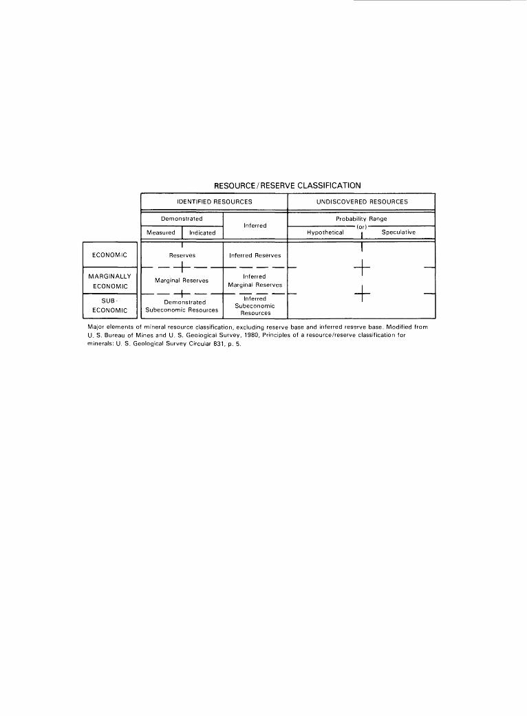
This report presents an evaluation of the mineral endowment (identified resources and mineral resource po tential) of the study area and is the product of several separate studies by the USBM and the USGS. Identified resources are classified according to the system of the USBM and USGS (1980), which is shown in the Appen dix of this report. Identified resources are studied by the USBM. Mineral resource potential is the likelihood of oc currence of undiscovered metals and nonmetals, of indus trial rocks and minerals, and of undiscovered energy sources (coal, oil, gas, oil shale, and geothermal sources). It is classified according to the system of Goudarzi (1984) and is shown in the Appendix of this report. Undiscovered resources are studied by the USGS.
Investigations by the U.S. Bureau of Mines
The USBM reviewed Socorro County and BLM rec ords for information regarding patented and unpatented claims, as well as federal mineral and oil and gas leases in or near the study area. No mineralized areas were found during the three days of field investigations in 1985; no samples were taken. Details of the study are provided in Korzeb (1986).
Investigations by the U.S. Geological Survey
Field investigations by the USGS in 1985 consisted of three days of geologic mapping and rock sampling of the wilderness study area and vicinity. No geochemical studies were undertaken. The lack of bedrock in the area, as well as the absence of alluvium known to be locally derived, ruled out the feasibility of a stream-sediment geochemical investigation. Large-scale gravity and aero- magnetic maps of the wilderness study area and vicinity were prepared from gravity data used for regional gravity maps of New Mexico and from a wide-spaced aeromag- netic survey flown for the NURE (National Uranium Re source Evaluation) program. No new geophysical data were acquired for this resource evaluation.
Acknowledgments. Personnel of the BLM in Socorro, N. Mex., especially geologist Roy Dean, were extremely helpful in providing both background informa tion on the wilderness study area and air photos of the area. Special thanks are also due to Glenn R. Osburn of the New Mexico Bureau of Mines and Mineral Re
sources in Socorro for providing a preliminary copy of the geologic map of Socorro County. A report on the geology, energy, and mineral resources of the Armendaris area, New Mexico (Krason, Jan, Wodzicki, Antoni, and Cruver, S.K., 1982, unpub. data) prepared for the BLM was a very useful guide for this assessment.
APPRAISAL OF IDENTIFIED RESOURCES
By Stanley L. Korzeb U.S. Bureau of Mines
No mining has been done in the Antelope Wilder ness Study Area nor are there any known deposits of either locatable or leasable minerals. The study area con tains no identified resources. The Carthage coal field (Os burn, 1983), which was active from about 1856 to 1967, is approximately 5 mi northeast of the wilderness study area (fig. 2). Production from 1899 to 1960 was more than a million metric tons of high-volatile A bituminous coal. The minable coal occurs in a single bed, 5-6 ft thick, in the lower part of the Upper Cretaceous Crevasse Canyon Formation, a part of the Mesaverde Group. The coal bed dips 12-35° and is locally highly faulted. No detailed geologic mapping has been done in the coal field, and the coal resource is not known.
Sand and gravel occur in the study area, but the current likelihood of development is low. Similar deposits are more readily available elsewhere in the Rio Grande river valley.
ASSESSMENT OF POTENTIAL FOR UNDISCOVERED RESOURCES
By Donald H. Richter and Richard W. Saltus U.S. Geological Survey
Geology
The wilderness study area is almost entirely under lain by alluvial and eolian deposits of Quaternary age; no bedrock older than late Tertiary in age (pre-Santa Fe Group) is exposed. However, Cenozoic to Paleozoic rocks do crop out in three areas, 1-3 mi outside of the wilder ness study area: (1) northeast of the study area, shale and sandstone of the Upper Cretaceous Mesaverde Group, sandstone and conglomerate of the Eocene(?) Baca Forma tion, and volcanic rocks of Oligocene age dip moderately
Antelope Wilderness Study Area B5

both to the east and west; (2) at Sand Mountain about 1 mi east of the study area, Oligocene volcanic rocks are exposed; and (3) southwest of the study area in the northern part of the Little San Pascual Mountains, Paleo zoic limestone (Magdalena Group) and Permian red beds (Abo Formation) dip steeply to the east.
The Quaternary alluvial and eolian deposits, which underlie the wilderness study area, may be as much as 100 ft thick and consist of unconsolidated alluvium in closed basins, broad fans marginal to upland areas, and sand dunes. These surficial deposits overlie perhaps be tween 1,000 and 4,000 ft of older alluvial deposits of the upper Tertiary and Quaternary Santa Fe Group, which were deposited in the tectonically active Rio Grande rift valley. Rocks of the Santa Fe Group are moderately indu rated fanglomerate and sandstone containing abundant vol canic debris, and unconformably overlie rocks ranging in age from middle Tertiary to Paleozoic. Oligocene volcanic rocks, along the east side of the study area, consist of flows and shallow intrusives chiefly of high-potassium an- desitic composition. The volcanic rocks show no evidence of hydrothermal alteration. As much as 1,000 ft of con glomerate and sandstone of the Eocene(?) Baca Formation may be present between the Oligocene volcanic rocks and the sandstone, shale, and coal of the Upper Cretaceous Mesaverde Group. The Paleozoic rocks exposed in the Little San Pascual Mountains southwest of the wilderness study area are faulted and strongly folded. Dips at the north end of the Little San Pascual Mountains are steep to the east.
The complex structures apparent in the pre-Santa Fe Group rocks near the wilderness study area indicate that the distribution and attitude of these strata beneath the study area can be inferred in only a very general way. Paleozoic limestone undoubtedly underlies the entire study area, but depth to these rocks may vary from 2,000 ft to as much as 6,000 ft (fig. 4). Mesaverde Group rocks may occur within a few hundred feet of the surface in the northern one-third of the study area, based on bedding attitudes measured entirely on exposures outside the study area.
Geophysics
Gravity Data
An isostatic residual gravity map of an area encom passing the wilderness study area is shown on figure 3. This map was compiled using data from about 600 gravity stations assembled and edited for regional gravity maps of New Mexico by Cordell and others (1982), and em
phasizes the gravity effect of density distributions in the upper crust (Simpson and others, 1986).
The wilderness study area is situated on the northern end of an elongate north-trending gravity high. This high is flanked on the west by steep gravity gradients leading down into the Rio Grande rift zone. On the east side of the high the gravity field drops to a very large closed gravity low (40 milliGals below the high) centered about 10.5 mi east of the wilderness study area.
The anomalies on the gravity map are probably primarily due to the relief on the contact between the rela tively low density Santa Fe Group sedimentary rocks at the surface and the underlying higher density Paleozoic carbonate rocks. Thus, the central gravity ridge indicates a shallow depth to the Paleozoic rocks and the large closed low to the east is caused by a relatively thick Santa Fe section. If the Paleozoic limestone is assumed to have a bulk density of 2.7 grams per cubic centimeter, the largest reasonable density contrast between the Paleozoic rocks and the Santa Fe Group is probably 0.5 grams per cubic centimeter. Using this density contrast and the method of Cordell and Henderson (1968), a map showing minimum depth to Paleozoic basement has been derived from the gravity map (fig. 4). The map shows that the Paleozoic basement is within 1,600 ft of the surface near the wilderness study area but is at least 10,000 ft deep under the gravity low to the east.
The very steep gradient just west of the wilderness study area (best defined by a line of closely spaced gravity stations on fig. 3) is probably associated with graben faulting along the Rio Grande rift to the west.
Aeromagnetic Data
An aeromagnetic map of the wilderness study area and vicinity is shown on figure 5. Data for the map were obtained as part of the NURE program in 1982 (Berry and others, 1982). The survey was flown at an altitude of 400 ft above ground along flight lines spaced 3 mi apart. Because the flight lines are so widely spaced, short- wavelength features cannot be contoured reliably from line to line. In order to avoid false correlation of these features by automatic contouring, a grid was produced from the original data using the method of minimum curvature (Briggs, 1974) and was then continued upward 1,600 ft to remove the short-wavelength features.
The aeromagnetic map is dominated by a large semicircular closed low with a triangle-shaped high indenting it from the west. These broad long-wavelength features are probably due to relief on the contact between the Precambrian basement and the relatively nonmagnetic
B6 Mineral Resources of Wilderness Study Areas West-Central New Mexico

107°00' 106°30'
33°45'
33°30'
Figure 3. Isostatic residual gravity map of the Antelope Wilderness Study Area (shaded) and vicinity, New Mexico. Contour interval 2 milliCals. Hachures indicate closed gravity low. Gravity station indicated byo. Reduction density 2.67 grams per cubic centimeter.
Antelope Wilderness Study Area B7
106°52'30' 106°37'30"
33°45' -
33030' _
Figure 4. Depth to Paleozoic basement below Santa Fe Group rocks in the Antelope Wilderness Study Area (shaded) and vicinity, New Mexico. Contour interval 200 (650 ft) meters.
rocks above. A two-dimensional model constructed along two flight lines crossing the broad low gives an estimated depth of about 20,000 ft to the Precambrian under the low part of the anomaly along the east edge of the wilder ness study area. This model assumes a 0.001 emu/cm3
(electromagnetic units per cubic centimeter) intensity of magnetization for a normally polarized basement. The same model yields depths of about 7,000 ft to Precambri an basement under the magnetic highs flanking the west edge of the wilderness study area.
B8 Mineral Resources of Wilderness Study Areas West-Central New Mexico

107°00' 106°30'
33°45'
33°30'
Figure 5. Aeromagnetic map of the Antelope Wilderness Study Area (shaded) and vicinity, New Mexico. Dashed lines indicate flight lines. Contour interval 10 nanoTesla. H, aeromagnetic high; L, aeromagnetic low.
Aerial Radiometric Survey Data
The Antelope Wilderness Study Area has low over all radioactivity. The aerial radiometric survey indicated values of 1.3-1.8 ppm (parts per million) equivalent ura
nium, 3.5-5.0 ppm equivalent thorium, and 1.6-2.1 per cent potassium (J.S. Duval, USGS, written commun., 1986). No anomalous radioactivity values are within or near the study area.
Antelope Wilderness Study Area B9

Mineral and Energy Resource Potential
Coal
The inactive Carthage coal field (Osburn, 1983), 5 mi northeast of the Antelope Wilderness Study Area, has produced high-volatile A bituminous coal from a 4- to 6-ft coal bed in the lower part of the Crevasse Canyon Formation, a formation of the Mesaverde Group of Late Cretaceous age. Mesaverde Group rocks crop out within 2 mi of the northern part of the study area, and their attitudes and those of the overlying rocks of the Baca Formation suggest that Mesaverde strata may be present within a few hundred feet of the surface in parts of the study area. The northern one-third of the study area is therefore given a moderate potential for coal resources, with certainty level B. The rest of the study area has a low potential for coal resources, with certainty level B.
Metals
Occurrences of uranium minerals are occasionally found in upper Tertiary and Quaternary sedimentary rocks of the Santa Fe Group throughout New Mexico (Hilpert, 1965). These deposits have been small and too low grade to mine. In the uranium assessment of the Tularosa, N. Mex., 1°X2° quadrangle, Berry and others (1982) indi cated that the Santa Fe Group is unfavorable for either uraniferous calcrete or sandstone uranium deposits. De spite these negative aspects, we believe that the presence of known deposits, adequate source terrane (Tertiary vol canic rocks), and local accumulations of organic debris in the host sediments are criteria that suggest locally favorable geologic environments, especially for sandstone- hosted deposits. In addition, the Baca Formation of Eo- cene(?) age, which probably underlies most of the north ern part of the study area, locally hosts uranium minerals to the north and west of the study area (S.L. Moore, USGS, written commun., 1986) and should be considered a potential uranium source. The entire study area is given a low potential for uranium resources, with certainty level B. The study area lacks the rocks and geologic environ ment favorable for metallic mineral deposits, and no mineralized areas were observed. The study area is there fore given a tow mineral resource potential for metals, with certainty level B.
Oil and Gas
The wilderness study area is underlain at depth by upper Paleozoic sandstone and limestone that are highly productive reservoir and source rocks in southeastern New Mexico. However, in the Rio Grande rift valley these rocks have been structurally disturbed and intruded by
igneous rocks, factors that do not enhance the rocks' abil ity to hold significant quantities of oil and gas. Three exploratory holes testing the Paleozoic section have been drilled about 6 mi west of the study area; all were dry (U.S. Geological Survey, 1981). The entire study area is assessed as having a low potential for oil and gas re sources, with certainty level B.
Sand
The southeastern part of the study area contains ac tive sand dunes with a maximum thickness of 25 ft. These areas have a high resource potential for sand, with cer tainty level C. The other Quaternary deposits in the area are heterogeneous and poorly sorted; they have a low min eral resource potential for sand, with certainty level B.
REFERENCES CITED
Berry, V.P., Nagy, P.A., Spreng, W.C., Barnes, C.W., and Smuse, DeForrest, 1982, Tularosa quadrangle, New Mexico (National Uranium Resource Evaluation): U.S. Department of Energy, GJQ-014(82), 22 p.
Briggs, I.C., 1974, Machine contouring using minimum curva ture: Geophysics, v. 39, no. 1, p. 39-48.
Cordell, Lindrith, and Henderson, R.G., 1968, Iterative three- dimensional solution of gravity anomaly data using a digital computer: Geophysics, v. 33, no. 4, p. 596-601.
Cordell, Lindrith, Keller, G.R., and Hildenbrand, T.G., 1982, Bouguer gravity map of the Rio Grande Rift, Colorado, New Mexico, and Texas: U.S. Geological Survey Geophysi cal Investigations Map GP-949, scale 1:1,000,000.
Geddes, R.W., 1963, Structural geology of Little San Pasqual Mountain and the adjacent Rio Grande Trough: Socorro, N. Mex., New Mexico Institute of Mining and Technology, M.S. thesis, 62 p.
Goudarzi, G.H., 1984, Guide to preparation of mineral survey reports on public lands: U.S. Geological Survey Open-File Report 84-787, 42 p.
Hilpert, L.S., 1965, Uranium, in Mineral and water resources of New Mexico: U.S. 89th Congress, 1st Session, Senate Committee on Interior and Insular Affairs, p. 209-226; re printed 1982, New Mexico Bureau of Mines and Mineral Resources Bulletin 87, 437 p.
Korzeb, S.L., 1986, Mineral investigations of the Antelope Wil derness Study Area (NM-020-053), Socorro County, New Mexico: U.S. Bureau of Mines Open-File Report MLA 17- 86, 6 p.
Osburn, J.C., 1983, Coal resources of Socorro County, New Mexico, in Chapin, C.E., and Callender, J.F., eds., Socorro region II: New Mexico Geological Society, 34th Field Con ference Guidebook, p. 223-226.
Osburn, G.R., and Chapin, C.E., 1983, Nomenclature for Ceno- zoic rocks of northeast Mogollon-Datil volcanic field, New Mexico: New Mexico Bureau of Mines and Mineral Re sources, Stratigraphic Chart SC-1.
B10 Mineral Resources of Wilderness Study Areas West-Central New Mexico

Simpson, R.W., Jachens, R.C., Blakely, R.J., and Saltus, U.S. Bureau of Mines and U.S. Geological Survey, 1980, Prin- R.W., 1986, A new isostatic residual gravity map for the ciples of a resource/reserve classification for minerals: U.S. conterminous United States with a discussion on the signifi- Geological Survey Circular 831, 5 p. cance of isostatic anomalies: Journal of Geophysical Re- U.S. Geological Survey, 1981, Energy resources of New search, v. 91, no. B8, p. 8348-8372. Mexico: U.S. Geological Survey Miscellaneous Investiga
tions Series Map 1-1327, scale 1:500,000.
Antelope Wilderness Study Area B11


APPENDIX
DEFINITION OF LEVELS OF MINERAL RESOURCE POTENTIAL AND CERTAINTY OF ASSESSMENT
Definitions of Mineral Resource Potential
LOW mineral resource potential is assigned to areas where geologic, geochemical, and geophysical charac teristics define a geologic environment in which the existence of resources is unlikely. This broad category embraces areas with dispersed but insignificantly mineralized rock as well as areas with few or no indications of having been mineralized.
MODERATE mineral resource potential is assigned to areas where geologic, geochemical, and geophysical characteristics indicate a geologic environment favorable for resource occurrence, where interpretations of data indicate a reasonable likelihood of resource accumulation, and (or) where an application of mineral-deposit models indicates favorable ground for the specified type(s) of deposits.
HIGH mineral resource potential is assigned to areas where geologic, geochemical, and geophysical charac teristics indicate a geologic environment favorable for resource occurrence, where interpretations of data indicate a high degree of likelihood for resource accumulation, where data support mineral-deposit models indicating presence of resources, and where evidence indicates that mineral concentration has taken place. Assignment of high resource potential to an area requires some positive knowledge that mineral-forming processes have been active in at least part of the area.
UNKNOWN mineral resource potential is assigned to areas where information is inadequate to assign low, moderate, or high levels of resource potential.
NO mineral resource potential is a category reserved for a specific type of resource in a well-defined area.
Levels of Certainty
U/A
UNKNOWN
POTENTIAL
H/B
HIGH POTENTIAL
M/B
MODERATE POTENTIAL
L/B
LOW
POTENTIAL
H/C
HIGH POTENTIAL
M/C
MODERATE POTENTIAL
L/C
LOW
POTENTIAL
H/D
HIGH POTENTIAL
M/D
MODERATE POTENTIAL
L/D
LOW POTENTIAL
N/D
NO POTENTIAL
O inLU CC.
B C
LEVEL OF CERTAINTY
A. Available information is not adequate for determination of the level of mineral resource potential.B. Available information suggests the level of mineral resource potential.C. Available information gives a good indication of the level of mineral resource potential.D. Available information clearly defines the level of mineral resource potential.
Abstracted with minor modifications from:
Taylor, R. B., and Steven, T. A., 1983, Definition of mineral resource potential: Economic Geology,v. 78, no. 6, p. 1268-1270.
Taylor, R. B., Stoneman, R. J., and Marsh, S. P., 1984, An assessment of the mineral resource potentialof the San Isabel National Forest, south-central Colorado: U.S. Geological Survey Bulletin 1638, p.40-42.
Goudarzi, G. H., compiler, 1984, Guide to preparation of mineral survey reports on public lands: U.S.Geological Survey Open-File Report 84-0787, p. 7, 8.
ECONOMIC
MARGINALLY
ECONOMIC
SUB-
ECONOMIC
RESOURCE/RESERVE CLASSIFICATION
IDENTIFIED RESOURCES
Demonstrated
Measured Indicated
1
Reserves
Marginal Reserves
Demonstrated Subeconomic Resources
Inferred
Inferred Reserves
Inferred Marginal Reserves
InferredSubeconomic
Resources
UNDISCOVERED RESOURCES
Hypothetical
Probability Range (or)-
Speculative
+
Major elements of mineral resource classification, excluding reserve base and inferred reserve base. Modified from U. S. Bureau of Mines and U. S. Geological Survey, 1980, Principles of a resource/reserve classification for minerals: U. S. Geological Survey Circular 831, p. 5.

GEOLOGIC TIME CHART Terms and boundary ages used in this report
EON
Phanerozoic
Proterozoic
Archean
pre-Arc
ERA
Cenozoic
Mesozoic
Paleozoic
Late Proterozoic
Middle Proterozoic
Early Proterozoic
Late Archean
Middle Archean
Early Archean
hean 2
PERIOD
Quaternary
Tertiary
Neogene
Subperiod
Paleogene
Subperiod
Cretaceous
Jurassic
Triassic
Permian
Carboniferous Periods
Pennsylvanian
Mississippian
Devonian
Silurian
Ordovician
Cambrian
3800? -
EPOCH
Holocene
Pleistocene
Pliocene
Miocene
Oligocene
Eocene
Paleocene
Late Early
Late Middle Early
Late Middle Early
Late Early
Late Middle Early
Late Early
Late Middle Early
Late Middle Early
Late Middle Early
Late Middle Early
-
BOUNDARY AGE IN
MILLION YEARS
- 0.010
- 1.7
- 5
- 24
OQ
- 55
CC
- 96
1 OO
one
-/v 240
-~ 330
oert
- 410
- 500
- ~ 570 1
- 900
- 1600
- 2500
- 3000
- 3400
dBBO.
' Rocks older than 570 m.y. also called Precambrian, a time term without specific rank.
2 Informal time term without specific rank.
U.S. GOVERNMENT PRINTING OFFICE: 1987 773-047/46,056 REGION NO. 8


'«» V
*5


