65


MINERAL SOILS vs ORGANIC SOILS
Are they really different ?
TROPICAL PEAT vs TEMPERATE PEAT
- Extent
- Differences
- Crops Planted / Uses
PAST DEFINITIONS OF PEAT
- Peninsular Malaysia
- Sabah
- Sarawak
CHARACTERISTICS OF TROPICAL PEAT
- Dome shape - Underlying substratum
- Peat maturity - Depth
- Wood - Surface wood
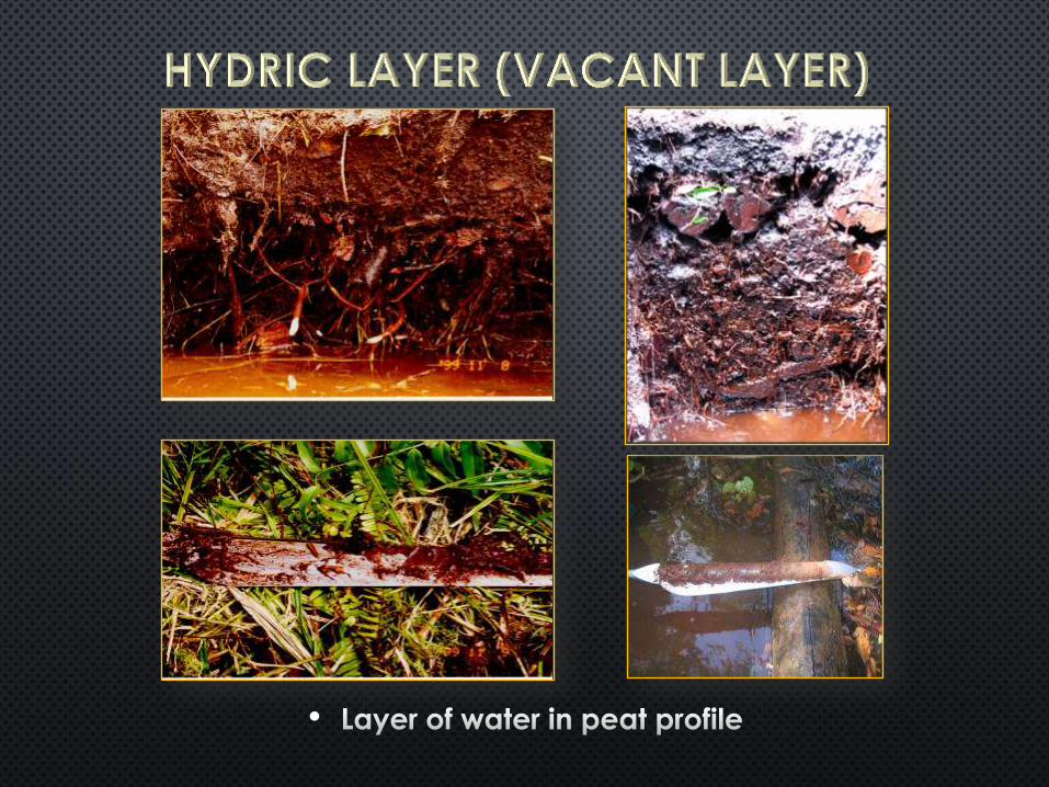
- Stumps of Shorea - Hydric layer
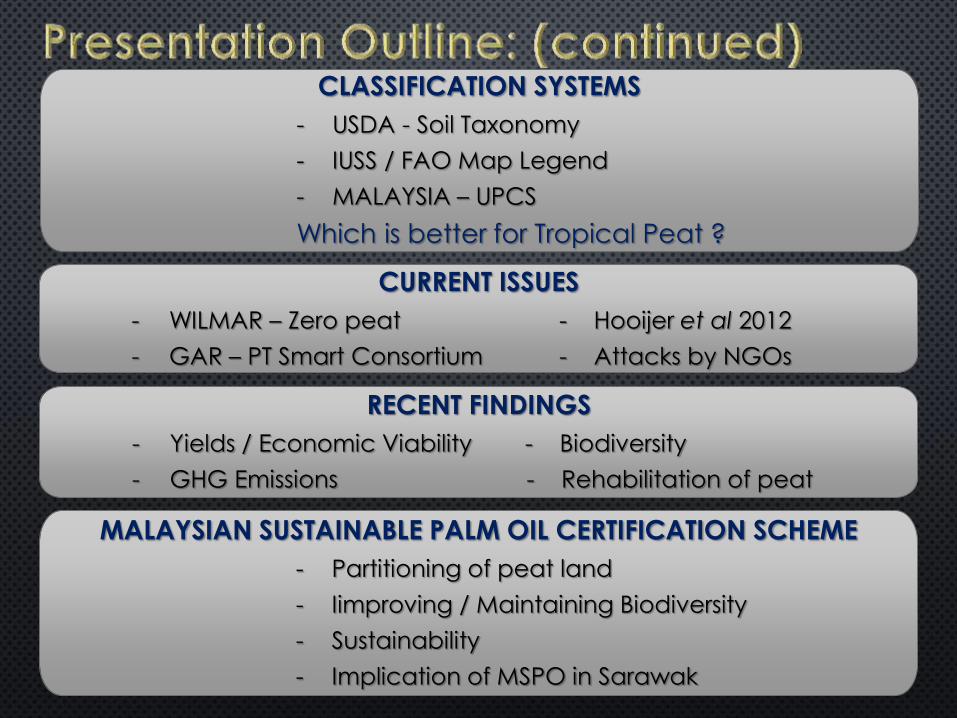
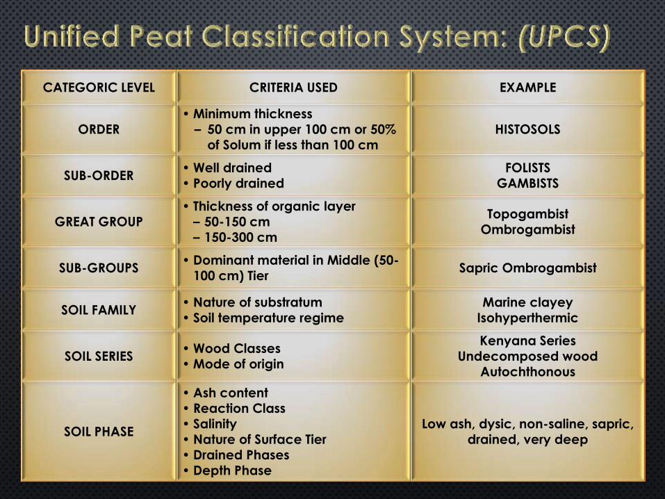
CLASSIFICATION SYSTEMS
- USDA - Soil Taxonomy
- IUSS / FAO Map Legend
- MALAYSIA – UPCS
Which is better for Tropical Peat ?
CURRENT ISSUES
- WILMAR – Zero peat - Hooijer et al 2012
- GAR – PT Smart Consortium - Attacks by NGOs
RECENT FINDINGS
- Yields / Economic Viability - Biodiversity
- GHG Emissions - Rehabilitation of peat
MALAYSIAN SUSTAINABLE PALM OIL CERTIFICATION SCHEME
- Partitioning of peat land
- Iimproving / Maintaining Biodiversity
- Sustainability
- Implication of MSPO in Sarawak

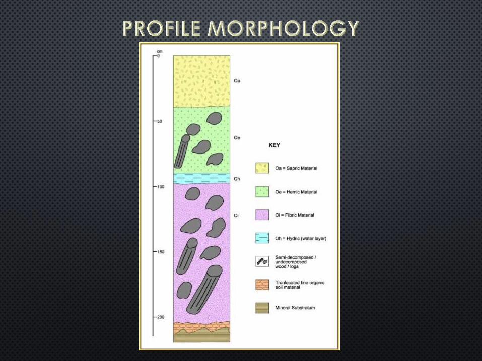
PEAT
(SAPRIC)
PEAT
(HEMIC) PEAT
(FIBRIC)
15-18% CLAY
COARSE LOAMY
18-35% CLAY
FINE LOAMY
>60% CLAY
VERY FINE
MINERAL SOILS ORGANIC SOILS

PEAT
WOOD
50-100 CM
PEAT
NO WOOD
PEAT
WOOD WITHIN
50 CM
CLAYEY-
SKELETAL
CLAYEY OVER
CLAYEY-
SKELETAL
CLAYEY
MINERAL SOILS ORGANIC SOILS
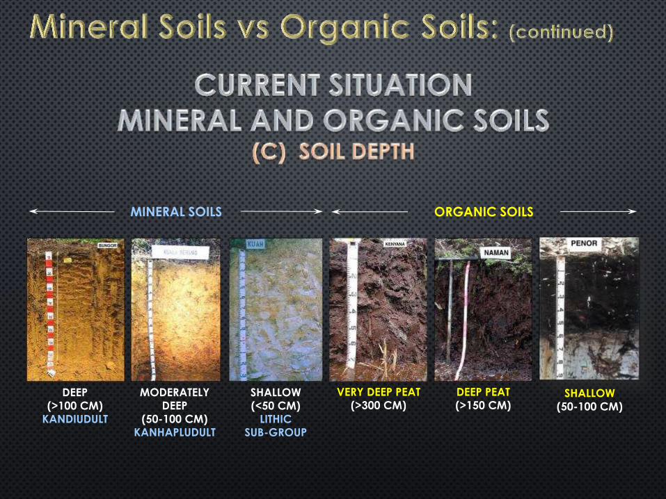
DEEP
(>100 CM)
KANDIUDULT
MODERATELY
DEEP
(50-100 CM)
KANHAPLUDULT
SHALLOW
(<50 CM)
LITHIC
SUB-GROUP
DEEP PEAT
(>150 CM)
VERY DEEP PEAT
(>300 CM)
ORGANIC SOILS MINERAL SOILS
SHALLOW
(50-100 CM)

-
-
-

All peats treated equally
Inherently Wrong
Use of temperate definitions / classification and management for tropical peats
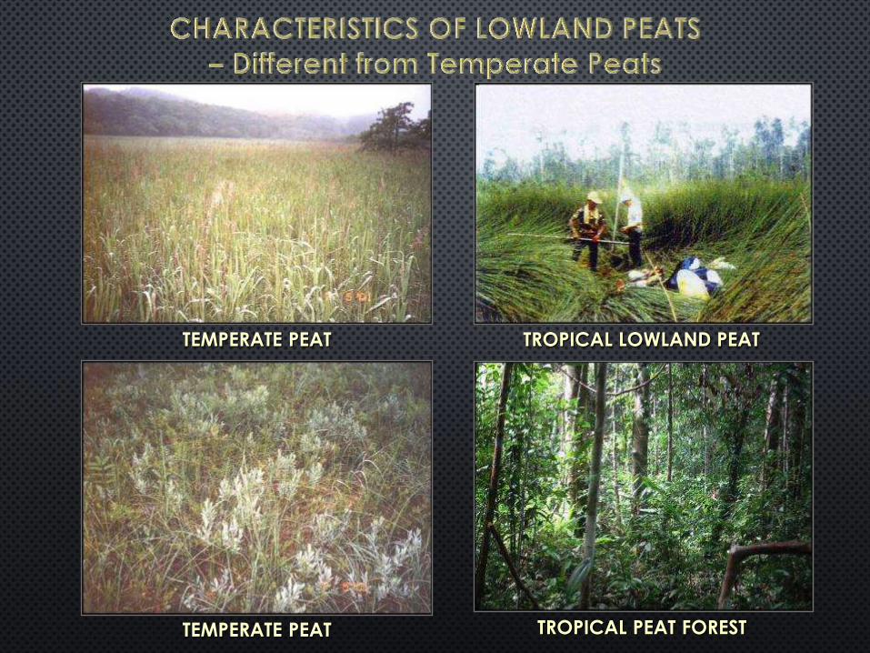
TEMPERATE PEAT
TEMPERATE PEAT
TROPICAL LOWLAND PEAT
TROPICAL PEAT FOREST


GLOBAL TROPICAL
REGION AREA (KM2) GLOBAL
(%)
TROPICAL
(%)
SOUTHEAST ASIA 202,600 4.65 56.6
CARIBBEAN 56,700 1.3 15.8
TROPICAL AND
SUBTROPICAL
PEATLAND
358,000 8.21 100
CONTINENT AREA (KM2) %
NORTH AMERICA 2,096,400 49.19
EASTERN EUROPE 1,519,578 35.65
GLOBAL PEATLAND 4,261,890 100
Source: Data summarised from Bord Na Mona (1984)
and Andriesse (1988)
Source: Andriesse (1988)
SOUTH EAST ASIA
COUNTRY RIELEY et al. (1995) (X MILLION) TIE, 1990
(X MILLION HA) MINIMUM (HA) MAXIMUM (HA) PER CENT
INDONESIA
MALAYSIA
17.00
2.25
27.00
2.73
82.00
8.28
26.20
2.56
TOTAL 19.93 32.94 100.00 30.07
Source: Rieley et al. (1995) and Tie (1990)

REGION HA %
SARAWAK 1,697,847 69.08
PENINSULAR MALAYSIA 642,918 26.16
SABAH 116,965 4.76
TOTAL: 2,457,730 100.00
EXTENT OF ORGANIC SOILS IN MALAYSIA
Source: Wetlands International, 2010

Author Definitions Used
Coulter, 1950
Eutropic
Mesotropic Oligotropic
Null, Acton and Wong, 1965 Wong, 1966
Inland Swamp Association
Leamy and Panton, 1966
Organic clay – Loss on Ignition 20-35%.
Minimum thickness 15 cm
Muck – Loss on Ignition 35-65%
Minimum thickness 60 cm
Peat – Loss on Ignition >65%
Shallow <60 cm
Moderately deep 60-150 cm
Deep >150 cm
Paramananthan, 1976 Organic Soils – Minimum thickness of 50 cm within upper 100 cm. Control Section – 0-30, 30-90, 90-120 cm
Paramananthan et al., 1984
Organic soils – Minimum thickness of 50 cm.
Control Section – 0-50, 50-100, 100-150 cm
Topogambist Peat 50-150 cm
Ombrogambist Peat >150 cm
Proposed use Folist – Well drained peats Gambist – poorly drained peats
Paramananthan, 1998 Proposed the Terms – Topogenous, Ombrogenous, Gambists
Paramananthan, 2010b Developed Keys to the Identification of organic soils

Soil Units Parent Materials Family
Dystric Histosol
(pH < 5.5 in some part
between 20-50 cm depth)
Peat (groundwater)
Klias
Peat (surface water)
Kaintano
Sulfidic Peat (> 0.75% sulfur)
Arang
Eutric Histosol
(pH > 5.5 in all horizons 20-50 cm depth)
Calcareous Peat Mengalum

Differentiae Criteria Used Remarks
Control Section 150 cm or depth to lithic/paralithic contact
Depth of Organic Soil
Materials (cumulative)
Shallow 50-150 cm Depth phases:
1 = 50-100 cm 2 = 100-150 cm
Deep > 150 cm Depth phases:
1 = 150-200 cm
2 = 200-250 cm 3 = > 250 cm
Nature of Mineral Substratum
Sandy substratum (< 15% clay)
Applied only to shallow families
Clayey, sulfidic substratum (> 15% clay)
Clayey, non-sulfidic substratum (> 15% clay)
Surface Vegetation Peat swamp forest Lowland swamp forests
Montane forests Altitudes over 1,000 m
Groundwater Table Present Unless artificially drained
Absent Non-present but material may be saturated
Ash Content
High ash content Weighted average ash content to 50 cm is > 10% (i.e. loss of ignition < 90%)
Low ash content Weighted average ash content to 50 cm is < 10% (loss of ignition > 90%)
Mode of Derivation Autochthonous In-situ build-up
Allochthonous Alluvial accumulation


Organosol (>50 cm OSM)
Fibrik Hemik Saprik

Histosols (>40 or 60 cm)
Gelic Thionic Folic Fibric Terric

CATEGORIC LEVEL CRITERIA USED EXAMPLE
ORDER • Minimum thickness – 50 cm in upper 100 cm or 50%
of Solum if less than 100 cm HISTOSOLS
SUB-ORDER • Well drained • Poorly drained
FOLISTS GAMBISTS
GREAT GROUP • Thickness of organic layer – 50-150 cm
– 150-300 cm
Topogambist
Ombrogambist
SUB-GROUPS • Dominant material in Middle (50-
100 cm) Tier Sapric Ombrogambist
SOIL FAMILY • Nature of substratum • Soil temperature regime
Marine clayey Isohyperthermic
SOIL SERIES • Wood Classes • Mode of origin
Kenyana Series Undecomposed wood
Autochthonous
SOIL PHASE
• Ash content • Reaction Class • Salinity
• Nature of Surface Tier • Drained Phases • Depth Phase
Low ash, dysic, non-saline, sapric,
drained, very deep
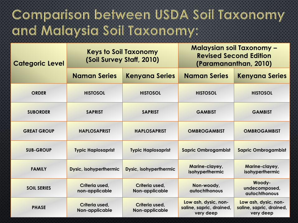
Categoric Level
Keys to Soil Taxonomy (Soil Survey Staff, 2010)
Malaysian soil Taxonomy –
Revised Second Edition (Paramananthan, 2010)
Naman Series Kenyana Series Naman Series Kenyana Series
ORDER HISTOSOL HISTOSOL HISTOSOL HISTOSOL
SUBORDER SAPRIST SAPRIST GAMBIST GAMBIST
GREAT GROUP HAPLOSAPRIST HAPLOSAPRIST OMBROGAMBIST OMBROGAMBIST
SUB-GROUP Typic Haplosaprist Typic Haplosaprist Sapric Ombrogambist Sapric Ombrogambist
FAMILY Dysic, isohyperthermic Dysic, isohyperthermic Marine-clayey, isohyperthermic
Marine-clayey, isohyperthermic
SOIL SERIES Criteria used,
non-applicable
Criteria used, Non-applicable
Non-woody, autochthonous
Woody-undecomposed, autochthonous
PHASE Criteria used,
Non-applicable
Criteria used, Non-applicable
Low ash, dysic, non-saline, sapric, drained,
very deep
Low ash, dysic, non-saline, sapric, drained,
very deep

Penor Gondang Anderson Salleh

• PADANG ALAN FOREST (PC-3)
• - SHOREA ALBIDA
Tristania-Parastemon-
Palaquium forest (PC-5)
Padang Paya forest (PC-6)


Decomposed
wood Undecomposed
wood
No wood

•

•
•

• High Altitude – Low B Density Moss
• >2/3 Fibres after rubbing (Remove Wood) Fibric
• 1/3 – 2/3 Fibres after rubbing (Remove Wood) Hemic
• <1/3 fibres after rubbing (Remove Wood) Sapric
• Decomposed or undecomposed pieces with cross-section diameter ≥2 cm Wood


Decomposed
wood Undecomposed
wood
No wood

Depth of OSM Name Mineral/Organic
Soils Current Issue
0 – 25 cm Organic Phase
Mineral Soils
1. WILMAR-
Zero Peat
2. RSPO- No new
planting on
peat
3. Indonesia- >300 cm
no planting
4. GAR-PT Smart-
No Plantation
on Peat >300
cm overlying
Sand / Sulfate
25 – 50 cm Histic Epipedon
50 – 100 cm Shallow
Organic Soils
100 – 150 cm Moderately
Deep
150 – 300 cm Deep
>300 cm Very Deep

Reference Subsidence Rate
Past Values
• Drainage with no control
• First 2 years 100 cm
• 5 cm per year
• 2 cm per year
Kool et al.
(2006)
• Subsidence : 220 – 400 cm
• Actual decomposition : 2 – 47 cm
RSPO • Subsidence 50%
• Decomposition 50%
Hooijer et al.
(2012)
• First 5 years 142 cm
Subsiquently 5 cm per
year
20 years cycle of oil palm
• 1st cycle 142+75 = 217 cm
• 2nd cycle = 100 cm
• 3rd cycle = 100 cm
• After 3 cycle = 417 cm
United Plantation- No more peat ?
Recent
Findings
• Thailand – 3 cm per year
• Malaysia – 2 to 3 cm per year

• Recent High Carbon Stock (HCS) Study – No new planting on peat
• 35 – 112 MtC/ha/year NGOs
• ‘Cutoff’ 42 MtC/ha/year ICCC
• Current values on peat 42 – 60 MtC/ha/year
MALAYSIA
CATEGORIC LEVEL CRITERIA USED EXAMPLE
ORDER • Minimum thickness – 50 cm in upper 100 cm or 50%
of Solum if less than 100 cm HISTOSOLS
SUB-ORDER • Well drained • Poorly drained
FOLISTS GAMBISTS
GREAT GROUP • Thickness of organic layer – 50-150 cm
– 150-300 cm
Topogambist
Ombrogambist
SUB-GROUPS • Dominant material in Middle (50-
100 cm) Tier Sapric Ombrogambist
SOIL FAMILY • Nature of substratum • Soil temperature regime
Marine clayey Isohyperthermic
SOIL SERIES • Wood Classes • Mode of origin
Kenyana Series Undecomposed wood
Autochthonous
SOIL PHASE
• Ash content • Reaction Class • Salinity
• Nature of Surface Tier • Drained Phases • Depth Phase
Low ash, dysic, non-saline, sapric,
drained, very deep

Categoric Level
Keys to Soil Taxonomy (Soil Survey Staff, 2010)
Malaysian soil Taxonomy –
Revised Second Edition (Paramananthan, 2010)
Naman Series Kenyana Series Naman Series Kenyana Series
ORDER HISTOSOL HISTOSOL HISTOSOL HISTOSOL
SUBORDER SAPRIST SAPRIST GAMBIST GAMBIST
GREAT GROUP HAPLOSAPRIST HAPLOSAPRIST OMBROGAMBIST OMBROGAMBIST
SUB-GROUP Typic Haplosaprist Typic Haplosaprist Sapric Ombrogambist Sapric Ombrogambist
FAMILY Dysic, isohyperthermic Dysic, isohyperthermic Marine-clayey, isohyperthermic
Marine-clayey, isohyperthermic
SOIL SERIES Criteria used,
non-applicable
Criteria used, Non-applicable
Non-woody, autochthonous
Woody-undecomposed, autochthonous
PHASE Criteria used,
Non-applicable
Criteria used, Non-applicable
Low ash, dysic, non-saline, sapric, drained,
very deep
Low ash, dysic, non-saline, sapric, drained,
very deep

••
TOPO
OMBRO
• PRESENCE / ABSENCE OF WOOD
NATURE OF WOOD:
─ DECOMPOSED
─ UNDECOMPOSED
•• PHASE LEVEL
•


• RSPO MAKES BLANKET RULING
- NO NEW OIL PALM ON PEAT
• MSPO MUST FACE REALITY

MSPO
New Areas for Development on Peat
Existing Oil Palms on Peat

Conduct Semi-detailed Soil Survey
Use Unified Peat Classification System
NEW AREAS
Technically suitable
Economically viable
CERTIFY AND PLANT
UNSUITABLE AREAS
Soils Unsuitable
OR
Economically not viable
DO NOT CLEAR FOR PLANTING

EXISTING AREAS
Due for replanting
Carry out Semi-Detailed Soil Survey using Unified Peat Classification
Technically suitable
Economically viable
BMPs Compliant
REPLANT
Technically unsuitable
OR
Economically not suitable
REHABILITATE TO FORESTRY
EXAMPLE:
(RAMESH ET AL., 2014)

Soil Series Soil Management Group Mean Range Standard
Deviation
Naman/
deep Oa (organic, sapric, no wood) 19.50 18.71- 20.62 0.89
Telong/
deep
Oawd (organic, sapric,
decomposed wood) 22.92 19.65-25.18 2.26
Bayas/
very deep
Oewd (organic, hemic,
decomposed wood) 13.37 11.71-15.33 1.31
Gedong/
very deep
Oewu (organic, hemic,
undecomposed wood) 9.467 8.17-10.70 0.91
Bako Mineral soil 13.65 10.28-16.01 2.19

Harvesting Year 1-11 (from 2003-2013.


Soil Series Description of Soils N
Cost of Development
Mean Range Standard Deviation
Naman/deep
(150-300 cm)
Oa (organic soil, sapric, with no
wood); underlying material marine clay.
4 5,552 5,470-5,630 75.19
Suai/very deep (>300 cm)
Oawu (organic soil, sapric with
undecomposed wood); underlying material marine sand.
6 7,123 7,000-7,196 79.79
Bayas/very deep (>300 cm)
Oewd (organic soil, hemic with
decomposed wood); underlying material marine clay.
5 6,037 5,925-6,120 71.37
Gedong/very deep (>300 cm)
Oewu (organic soil, hemic with
undecomposed wood); underlying material marine clay.
5 8,545 8,480-8,612 55.02
Bako (weakly
cemented) (spodic 50-100 cm)
Mineral soil, underlying material sandstone.
6 5,068 4,810-5,820 184.84


MAINTAIN / INCREASE EXTENT OF PRISTINE PEAT SWAMP FOREST
UNDEVELOPED PEAT SWAMP FORESTS (>50% UNDEVELOPED)
STUDIES TO BE CONDUCTED
- SEMI-DETAILED SOIL SURVEY
- IDENTIFY HIGH CONSERVATION VALUE AREAS
- TECHNICALLY UNSUITABLE
- ECONOMICALLY NOT VIABLE
- POTENTIAL GHG EMISSIONS
- PRESENCE OF ENDANGERED SPECIES
- OTHER FACTORS WHICH FAVOUR CONSERVATION
DESIGNATE AS CONSERVATION AREA

DELINEATE AREAS FOR BIODIVERSITY
CONSERVATION
- RIPARIAN AREAS
- ACTIONS TO ATTRACT WILDLIFE
- FISH PONDS
- BENEFICIAL PLANTS
- BIRD PERCHES
- INCREASE FOOD SOURCES


Type of
Soil
Group
Soil
Management
Group
Soil Map
Units
Main
Characteristic/
Limitation
Management
Practices Needed
Peak Yield
Potential
Retus (Sibu)
Complex
mt/ha/yr Ha %
Min
era
l S
oil
L Nyl/3
Klt/3
Deep to moderately deep sandy loam textured
soils. Well drained. Moisture stress and yield
fluctuations. Highly erodable soils on steeper
slopes. Very low fertility.
Soil erosion monitoring and mitigation.
• Cover crop establishment.
• Terracing.
• Frond stacking.
• EFB application.
• Good fertilizer programme.
• Monitor K levels.
24-28 260.8 1.5
D
Tka/3
Tka/4
Bko/3
Bko/4
Moderately deep (50-100 cm) sandy (<10% clay)
soils with albic and spodic horizons.
Excessively drained.
Moisture stress and yield fluctuation.
• EFB application.
• Frond stacking.
• Erosion monitoring and mitigation.
• Soil moisture conservation.
• Cover crop (Mucuna) establishment.
• Additional fertilizers (split). Break cemented pan.
18-24 594.2 3.4
Org
an
ic S
oil
Oa
Oc/1
Lgi/sh/1
Nmn/d/1
Nmn/vd/1
Shallow (50-100 cm), deep (150-300 cm) and very
deep (300+ cm) sapric material, non-woody.
Poorly drained. Low fertility.
Compaction of planting rows.
High planting density.
Water control and management.
Good fertilizer programme with Cu, B and Zn.
26-28 7,491.2 42.6
Oawd Rts/d/1
Rts/vd/1
Deep (150-300 cm) to very deep (300+ cm) sapric
material with decomposed wood. Poorly drained.
Stunted growth common after five years.
Termites. Low fertility.
Compaction of planting rows.
High planting density.
Water control and management.
Good fertilizer programme with Cu, B, Zn.
Thinning of stunted palms.
24-26 2,394.0 13.7
Oawu Kna/vd/1
Very deep (300+ cm) sapric material with
undecomposed wood. Poorly drained. Stunted
growth common after five years. Termites. Low
fertility. High cost of drain construction.
Compaction of planting rows.
High planting density.
Water control and management.
Good fertilizer programme with Cu, B, Zn.
Thinning of stunted palms.
22-24 3,339.4 19.1
Oewd Bys/vd/1
Very deep (300+ cm) hemic material with
decomposed wood. Poorly drained. Stunted
growth common after five years. Termites. Low
fertility. High cost of drain construction.
Compaction of planting rows.
High planting density.
Water control and management.
Good fertilizer programme with Cu, B, Zn.
Thinning of stunted palms.
20-22 1,414.2 8.1
Oewu Ged/vd/1
Very deep (300+ cm) hemic material with
undecomposed wood. Poorly drained . Stunted
growth common after five years. Termites. Low
fertility. High cost of drain construction.
Compaction of planting rows.
High planting density.
Water control and management.
Good fertilizer programme with Cu, B, Zn.
Thinning of stunted palms.
20-22 1,986.5 11.3
Miscellaneous Land Units (TEMUDA, Mill Complex, Quarry, Water body) 49.5 0.3
Total: 17,530.8 100.0

Soil
Management
Group
Soil Map Units
Main Characteristic/ Limitation
Management Practices Needed
Peak Yield
Potential TOTAL
mt/ha/yr Ha %
A Bdp/3
Deep (>100 cm), fine sandy clay to
clay (>35% clay) textured soils.
Soil erosion on steeper slopes. Low fertility.
Soil erosion monitoring and
mitigation: • cover crop establishment. • terracing. • frond stacking. Good fertilizer programme.
28-32 31.2 0.2
C Bjt/1
Deep (>100 cm), imperfect to
poorly drained alluvial soils. Textures clay to sandy clay to sandy clay loam. Flooding and high water tables. Low fertility status.
• Drainage and flood mitigation. • Good fertilizer programme.
28-34 51.6 0.4
Oa
Pnr/sh/1 Erg/sh/1 Erg/md/1 Lku/d/1 Lku/vd/1
Shallow (50-100 cm), moderately
deep (100-150 cm), deep (150-300
cm) to very deep (300+ cm) sapric
material, non-woody. Poorly
drained. Low fertility.
Compaction of planting rows. High planting density. Water control and management. Good fertilizer programme with Cu,
B and Zn.
26-28 4,677.6 34.6
Oawu Krp/vd/1
Very deep (300+ cm) sapric
material with undecomposed wood.
Poorly drained. Stunted growth
common after five years. Termites.
Low fertility. High cost of drain
construction.
Compaction of planting rows. High planting density. Water control and management. Good fertilizer programme with Cu, B, Zn. Thinning of stunted palms.
22-24 8,744.1 64.8
Total: 13,504.5 100.0

Soil
Management
Group
Soil
Map
Units
Main
Characteristic/
Limitation
Management
Practices
Needed
Yield
Potential Total
Mt/ha/yr Ha %
Cc Oc/1
Deep (>100 cm) light gray clay to brown
organic clay. Poorly drained. Flooding
and high watertables.
Drainage and flood mitigation.
Good fertilizer programme. 28-30 171.5 2.3
Cs Ttu/1
Mtu/1
Deep (>100 cm), light gray to brown
sand. Poorly drained. Low fertility.
Sandy textures. Yield fluctuations.
Drainage and water control.
Good fertilizer programme. 26-28 540.6 7.3
Oa
Lgi/md/1
Brm/sh/1
Brm/md/1
Nmn/d/1
Shallow (50-100 cm), moderately deep
(100-150 cm), deep (150-300 cm) to very
deep (300+ cm) sapric material, non-
woody. Poorly drained. Low fertility.
Water control and management.
Good fertilizer programme with Cu, B
and Zn.
26-28 2,166.1 29.6
Oawd Tel/d/1
Tel/vd/1
Shallow (50-100 cm), moderately deep
(100-150 cm), deep (150-300 cm) to very
deep (300+ cm) sapric material with
decomposed wood. Poorly drained.
Stunted growth common after five years.
Termites. Low fertility.
Water control and management.
Good fertilizer programme with Cu, B,
Zn.
Thinning of stunted palms.
24-26 3,739.9 51.1
Oawu Sui/d/1
Sui/vd/1
Shallow (50-100 cm), moderately deep
(100-150 cm), deep (150-300 cm) to very
deep (300+ cm) sapric material with
undecomposed wood. Poorly drained.
Stunted growth common after five years.
Termites. Low fertility. High cost of
drain construction.
Water control and management.
Good fertilizer programme with Cu, B,
Zn.
Thinning of stunted palms.
22-24 709.9 9.7
Total: 7,328.0 100.0

GHG Measurements using chamber
method to obtain quick results
Using UPCS to locate areas with different types of peat
Oa Oawd Oawu
Oe Oewd Oewu
Oi Oiwd Oiwu
MPOB / SOP / PASS Co-operation
• Preliminary results – 4 months
• Long term results – 1 year

Mapping Peat areas using
UPCS is pivotal to
management of oil palm in
a scientific, responsible,
economic manner without
compromising social
considerations

Therefore mapping of peat
areas using UPCS assumes
cardinal importance for:
- Oil Palm establishment &
Management
- MSPO Certification
- Potential landuse planning on a catchment scale

UPCS is realistic and
practicable in addressing
sustainability certification for
oil palm on peat

MSPO embodies all the five
FAO principles for sustainable
development
o Improving efficiency in the use of
resources;
o Conserving, protecting and enhancing
natural ecosystems;
o Protecting and improving rural livelihoods
and social well-being;
o Enhancing the resilience of people,
communities and ecosystems; and
o Promoting good governance of both
natural and human systems.


