MINERALIZATION AT THE CONVERGENCE OF THE AMETHYST AND OH FAULT SYSTEMS,
CREEDE DISTRICT, MINERAL COUNTY, COLORADO
byPhilip Michael Giudice
A. Thesis Submitted to the Faculty of theDEPARTMENT OF GEOSCIENCES
In Partial Fulfillment of the Requirements For the Degree of
. MASTER OF SCIENCEIn the Graduate College
THE UNIVERSITY OF ARIZONA
1 9 8 0
STATEMENT BY AUTHOR
This thesis has been submitted in partial fulfillment of requirements for an advanced degree at The University of Arizona and is deposited in the University Library to be made available to borrowers under rules of the Library.
Brief quotations from this thesis are allowable without special permission, provided that accurate acknowledgment of source is made. Requests for permission for extended quotation from or reproduction of this manuscript in whole or in part may be granted by the head of the major department or the Dean of the Graduate College when in his judgment the proposed use of the material is in the interests of scholarship. In all other instances, however, permission must be obtained from the author.
SIGNED:7
APPROVAL BY THESIS DIRECTORThis thesis has been approved on the date shown below:
J./ML GUILBERT Profess'op of Geosciences
Date
ACKNOWLEDGMENT S
I would like to thank Paul Eimon, of Chevron Resources.Company? who originally brought this project to my attention and whose professional and moral support have been of great value to me, EimonT-s suggestions on the confidentiality of this document have been gratefully accommodatedo
This work has benefited greatly from the numerous discussions and helpful guidance of my academic advisors Dr, John Guilbert, Dr, Spencer Titley, and Dr, John Anthony, The detailed critical reading of this manuscript by John Guilbert has greatly enhanced this thesis.
My thanks are also extended to Chevron Resources Company for providing me access to the area of investigation and for supporting me on a parallel investigation during this study, Freeport Exploration Company kindly provided drafting and typing services.
Work on the Scanning Electron Microprobe was funded by a general research grant from the National Science Foundation, administered by Dr, M, Drake, Tom Teska patiently instructed and assisted me in the use of the microprobe.
Research for this thesis was concurrent with the U, S, Geological .Survey’s investigation of the Creede district. My association with these researchers has benefited this thesis greatly. Specifically, Drs, Bob Rye, Phil Bethke, Paul Barton, and Tom Steven have contributed numerous suggestions, particularly with regard to how this work may fit
ii±
ivinto the evolution of the entire research effort. Bob Rye's critical reading of this manuscript is also gratefully acknowledged.
Also concurrent with this thesis was my association with the exploration activities of Chevron Resources Company, directed by Paul Eimon. Many geologists worked on this exploration project and their numerous contributions have been appreciated, specifically those of John Beeder, Rick Robinson, Bruce Surgenor, and John Rice.
I am also indebted to my fellow graduate students at The University of Arizona who have contributed greatly to my understanding of ore- forming processes and the evolution of this mineralized system, especially Fleetwood Koutz, Jim Reynolds, and Lou Lepry.
Finally, I would like to thank my wife Marcia, for.without her motivation and support- this project may have never come to fruition.
TABLE OF CONTENTS
PageLIST OF ILLUSTRATIONS viiLIST OF TABLES ......... ixABSTRACT . . . . . . . . ............................. . x
VI. ALTERATION ........... 80Morphology........... 81Mineralogy......................................... 83Z o n i n g ................. 83Paragenesis............... 84
VII. SUMMARY AND SYNTHESIS ., ........ . . . . . . . . . . . . . 86REFERENCES C I T E D ............... 92
LIST OF ILLUSTRATIONS
Figure Page1. Creede District Oblique Aerial Photo (Facing
Northwest) ................ . . 42. Creede District Location Map . . . . . . . . . . 53. Prospects and Mines of the Creede District . . . . . . . . 104. Calderas of the Central San Juan Volcanic Field ........ 185. Detailed Description of the Bachelor Mountain Member . . . 206. District Bedrock Geology . . . . . . . . . .......... . . 267. Major Structures of the Emperius Mine . . . . . . . . . . 278. District Mineral Zoning 329. Vein Strike Complexities . . . . . . . . . . . . . . . . . 3910. Vein Dip Complexities . . . . . . . . . . . . . . . . . . 4011. Wall Rock Vein Contact . . . . . . . . . . . . . . . . . . 4112. Dark Acanthite in Quartz Vein Material . . . . . . . . . . 4913. Vein Assemblages Paragenefic Relations . . . . . . . . . . .5214. Vein Assemblage Spatial Relations .............. . . .' 5415. Hypothetical Disseminated Mineralization and Alteration
Patterns ........ . . . . . . . . . . . . 5616. Disseminated Mineralization Fracturing Styles .......... 5817. Distribution of the Disseminated Sulfides Acanthite,
Table Page1. Creede District Production ........ 92. Geologic Column •........ 173. Comparison of Whole Rock Eire Assay and Microprobe
Analysis of Mineral Constituents . . . . . . . . . . . . . 374. Vein Mineral Assemblages ........ 43
ix
ABSTRACT
Field and laboratory mineralogic studies of samples taken from Creede, Colorado have shown the presence of two forms of mineralization: relatively well-understood classic epithermal vein mineralization and newly discovered multi-stage disseminated mineralizatione The vein mineralization is here divided into nine assemblages based on megascopic field relationso Quartz in several varieties is the most abundant con^ stituent of the vein mineralization. A paragenetic sequence and spatial distribution are presented. The disseminated mineralization is inconspicuous, fine-grained, occurs at relatively low abundance at less than two volume percent, and exhibits no systematic tendency for increasing values with approach to major structures. Silver itself is the most important economic component of the suite of disseminated mineralization. It occurs primarily as sulfides; occupies a restricted, late position in the paragenetic sequence; and is found in irregular pods within broader zones of disseminated mineralization. A complex model of origin of the disseminated mineralization and associated wall rock alteration includes the interaction of stratigraphic, structural, and chemical phenomena.
x
CHAPTER I
INTRODUCTION
The presence of economically important disseminated mineralization has only recently been recognized in epithermal silver districts. Recent economic incentives reflected in high silver prices have made one troy ounce recoverable silver, or 31.3 grams, per ton attractive to many companies. These economic incentives in turn have stimulated interest in reevaluating previously mined silver districts. ,
This study was designed to clarify mineralogy and ore controls in the upper portions of the Amethyst and OH fault systems of the Creede Mining District, Mineral County, Colorado. This zone, considered favorable for large tonnage ore bodies, has higher silver values and higher fracture densities than deeper zones. Exploration activity in 1978-79 provided access to several mine levels which had been sealed off since 1940, affording excellent three-dimensional exposure of the zone of disseminated mineralization. This new access, plus the background work of over 20 calendar years of research by members of the U. S. Geological Survey in other parts of the system, were the primary reasons for choosing the Creede study area.
Many geologic tools were employed in the process of this study. Sixteen weeks were spent between June, 1978 and April, 1979 mapping and sampling in the field. Due to limited surface exposure in the area of interest, all field study, aside from surface reconnaissance, was
conducted underground. Geologic mapping was undertaken to determine megascopic relations. Laboratory studies were undertaken to identify silver-bearing phases and to develop specific relations between wall- rock alteration, disseminated mineralization, and vein assemblages.
Scores of samples collected covered the entire accessible volume on the Chance 2, Sloan/Ruth Elder, P & E 60, P & E 150, Amethyst 5, and Commodore 5 levels of the Emperius Mine. Samples were chosen to exhibit the range of megascopic variations in alteration and mineralization; transition zones between alteration types were extensively sampled. Samples were analyzed using ore microscopy, thin section petrography, x-ray diffraction, scanning electron microscopy, and quantitative electron microprobe analysis. Metric system terminology was used when not in conflict with district practice. For example, all elevations are given as feet above sea level, but all petrographic data are metric.
The organization of this paper, in line with the course of this study, concentrates on the distribution and occurrence characteristics of ore mineralization and unraveling the controlling processes involved. Previous investigations and production history are presented in chronologic format with a table showing past production in 1980 metal prices. Regional geologic history, the district geologic column, and an account of structural characteristics have been included as background information with emphasis on aspects pertinent to mineralization. Discussion of mineralization was subdivided into two sections concerning previously mined and well-understood vein mineralization, and disseminated miner-
Ialization which is only recently of economic importance. Wall-rock
alteration is discussed, concentrating on its spatial and genetic association with mineralization. These data are summarized in a section on interpretation of the evolution of this hydrothermal system.
GeographyThe Creede Mining District (Figure 1), located at the geographic
center of the San Juan volcanic field (Figure 2), comprises all of the mines within a few miles of the town of Creede, Mineral County, Colorado (latitude 37°53’N, longitude 106°57’W) . Elevations vary between 8,500 ft at the Rio Grande Valley to 14,000 ft at the Continental Divide; mine workings studied cover a 1,025 ft vertical interval between 9,225 ft and 10,251 ft. Less than 5% of the district is outcrop, the rest being covered by glacial debris, soil, and vegetation. Most of the productive veins in the district have little or no surface expression. Scattered clay alteration, minor silica veining, and slight topographic depressions are the only surface traces of major vein systems. Were it not for fortuitous erosion, this epithermal district might never have been discovered. Access to the area of investigation was good, since recently reopened workings afforded good exposure to the central portion of the study area. Heavily muddied mine walls made geologic mapping slow and obscured inconspicuous transitions between alteration and mineralization types. The mine was generally dry and warm, and temperatures varied between about 45 and 55°F. Overall, this area was well suited for study.
Figure 1. Creede District Oblique Aerial Photo (Facing Northwest).
5
COLORADO
W & W J .
G U N N I S O NM O N T R O S E
OURAY
BA
LVERTON
D U R A N G O
t̂iixdx«AbtiM EXICON E W
1 0 0 Km
37"
C o I d e r a s o f the San Juan Vole a n i c F i e l d
B, B o n a n z a BA, B a c h e lo rC, C re e d e CO, C o c h e to p aG, L a G a r i t aH , Mf. H o p eL , L a k e C ity LL, Lo st L a k e
Ou a t e r n a r y - T e r t i a r y sediments
\ \ \ \ \\ \ \ \ \
P , P la to ro S , S H v e r to n SJ, S a n Juar\S L , S an L u is SM S u m m it v i l le U , U te C reek U N , U n c o m p a h g re
T e r t i a r y i n t r u s i v e ; _________
T e r t i a r y v o l c a n i c s _________Mesozoi c - Paleozoic sed i ment a r y r o c k s _________
P r e c a m br i a n _______________
Figure 2. Creede District Location Map. — After Casadevall and Ohmoto(1977).
Previous Investigations Many distinguished and dedicated scientists have studied the
Creede district. Geology of the Creede district was first reported by Hayden (1877). His study was a regional study encompassing all of Colorado and parts of adjacent territories. Following the discovery of ore in 1891, a flurry of articles describing the district appeared in various scientific and mining journals. The more notable of these are Kirby (1892), MacMechen (1892), Rickard (1897), and Lee (1903). Emmons and Larsen (1913, 1923) published the first comprehensive geologic investigation of the geology and ore deposits at Creede. Larsen (1929) followed up earlier reports with an account of developments between 1913 and 1927. Hills (1924) was the first to report on the occurrence of silver in carbonaceous trash in the sedimentary Creede formation. In 1950, Cannaday detailed the ore mineralogy of the OH vein and discussed some of the structural features at the convergence of the OH and Amethyst veins. Steven and Ratte (1960) published the first recommendation of exploration in the Bulldog fault zone which, five years later, led to a major new discovery. Steven and Ratte (1965) presented new surface and underground geologic mapping and comprehensively reviewed the geology of the .Creede district. A detailed analysis of the petrography and whole- rock geochemistry of the volcanics in the Creede district was released by Ratte and Steven (1967). A major U. S. Geological Survey effort to understand a hydrothermal system in detail was begun in 1959. This effort has concentrated on the accessible OH vein in an attempt to identify and define the physical and chemical parameters with which to
quantify the environment of hydrothermal mineralization. Detailed ore petrography, fluid inclusion studies, oxygen, hydrogen, carbon, and yet-to-be-released sulfur isotope investigations, x-ray analysis of clay minerals, and detailed isotopic dating of ore minerals and district-wide volcanic rocks have been incorporated into this effort. Many researchers have taken part in this project and many papers have been generated (Bethke, Barton, and Bodine, 1960; Roedder, 1960, 1977; Barton, Bethke, and Toulmin, 1963, 1971; Steven and Friedman, 1968; Steven, 1969; Bethke and Barton, 1971; Bethke, Rye, and Barton, 1973; Wetlaufer, 1977). Currently, this work is being released in a continuing series of papers in Economic Geology (Steven and Eaton, 1975;Bethke et al., 1976; Barton et al., 1977; Bethke and Rye, 1979). Geology and alteration north of the Creede district was studied by Chafee (1967) in an unpublished Ph. D. dissertation, and Hull (1970) provided the first comprehensive study of the Bulldog vein system. Creede district surface geology was revised by Steven and Ratte (1973).
Production History Several publications describe the Creede district production
history in detail. Meeves and Darnell (1968) compiled the Creede district’s production history as part of a broader U. S. Bureau of Mines study to evaluate United States silver resources. Production data have been recorded in various U. S. Bureau of Mines bulletins and mineral yearbooks since 1923. Prior to 1923, the U. S. Geological Survey Mineral Resource annual volumes contained sporadic production records. A
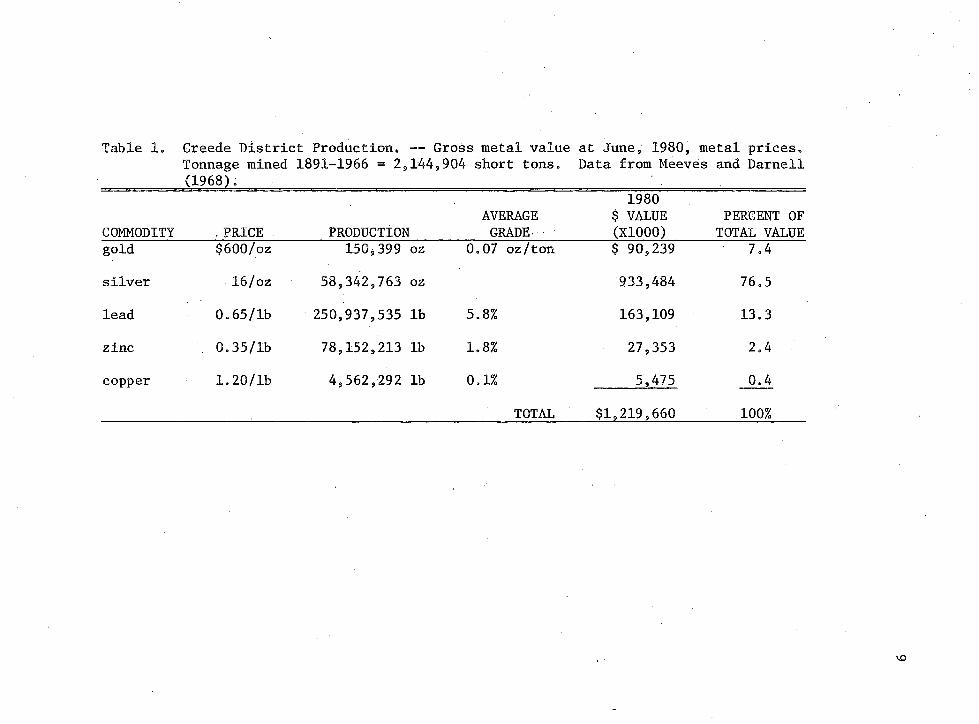
8summary of total district production is presented in Table 1. In terms of June, 1980,metal prices, the district's past production would have a 1,2 billion dollar gross metal value, with a silver-to-gold production ratio of 388 to 1.
A brief historical account of the discoveries which have been made in the Creede mining district are presented chronologically. Prospects and mines in the Creede district are located on Figure 3, Mineralization was first discovered in 1968 on the Alpha claim along the Alpha Corsair fault. Production did not last, due primarily to inadequate metallurgical technology. In 1889, Nicholas Creede made the first major ore discovery along the Solomon-Holy Moses vein, which was followed by ore discoveries along the Amethyst fault in 1891. These developments caused a rapid population increase from 600 in 1889 to 10,000 injust two years in the town of Creede. By 1900, the bulk of the high-grade silver from the southern third of the Amethyst vein had been mined out. By 1915, lead, zinc, some silver, and minor gold and cadmium were being mined from the base metal zone in the north portion of the district. As high-grade silver ore diminished so did the mining activity. Due to a sharp drop in the price of silver in 1930, all mines in the district closed. Many mines were rejuvenated in 1934 when the federal government put a floor under the price of silver at roughly twice the then-current free market price. The next major development was the discovery in 1938 of the OH vein, a major new structure. This event wassoon followed by the Strategic Metals Act which de-emphasized precious metals in favor of base metals, motivating the miners to follow the
Table 1. Greede District Production. -— Gross metal value at June, 1980, metal prices.Tonnage mined 1891-1966 = 2,144,904 short tons. DaLta from Meeves and Darnell
Figure 3. Prospects and Mines of the Creede District. The mines numbered 2-B are controlled by the Emperius Mining Company (after Meeves and Darnell, 1968).
11
district zoning north, away from the silver-rich areas and into the lead- and zinc-rich areas. Exploration instigated by Steven and Ratte (1960) led to the discovery in 1961 of a major new vein system, the Bulldog. This fault zone had been sporadically prospected since the 1890*s. Production,did not begin until 1969 due to the difficulties in mining narrow vertical veins (Jackson, 1974). This discovery was the last major development in the Creede district production history until 1978. A substantial exploration effort, instigated by Paul Eimon of Chevron Resources, is currently underway to prove out the economic viability of bulk tonnage mineralization in the Emperius Mine workings.
CHAPTER II
REGIONAL GEOLOGIC HISTORY
The regional geology of the San Juan volcanic field, only briefly to be outlined here, has most notably been reported by Lipman, Steven, and Mehnert (1970), Steven (1975), Steven and Lipman (1976), and Lipman et al. (1978). The central San Juan volcanic field may lie directly on Precambrian basement (Tweto, 1968), since no rocks between Tertiary and Precambrian age are exposed within 25 miles of the Creede district (Figure 2). Magnetic and gravity geophysical tests do not resolve this question. Similarly, studies of the isotopic composition of minerals from the Creede district have been inconclusive. Bethke and Rye (1979) and Doe et al. (1979) present isotope data on the ores of Creede that neither confirm nor negate the possibility of underlying Mesozoic rocks. Three periods of regional Tertiary geologic history may be defined by compositional changes in eruptive rocks.
The first eruptive period occurred in early Oligocene, when eruptions from widely scattered volcanic centers coalesced into a volcanic field which covered the southern Rocky Mountains. These eruptions began about 40 m.y. ago and peaked in activity between 35 and 30 m.y. ago. The rocks formed were fundamentally andesitic lavas and breccias. Approximately two-thirds' by volume of the volcanic field erosional remnant is composed of these rocks. Lipman et al. (1970) estimate that
Ooriginally 40,000 km were erupted during this time span.12
13The second period began about 28 m.y. ago with eruption of vo
luminous ash flows in the western San Juans. One million years later, while ash flows were still being erupted to the west, the central San Juans erupted. About 26.5 m.y. ago, after just 3.5 m.y., eruptions of the main ash flow sheets, which ranged in composition from quartz la- tite to rhyolite, had ended. Sixteen major ash. flow sheets, generally coextensive with the earlier andesites, were erupted. Lipman et al.(1978) summarized the ages of these ash flows. Caldera-forming subsidence was concurrent with the ash flow eruptions. Fifteen known cal- deras (Figure 2) were formed during this 8 m.y. interval. Plouff and Pakiser (1972) theorized the epicrustal emplacement of a great batholith concurrent with this event, based on interpretations of gravity and magnetic data. As the batholith worked its way up and evolved with time, eruptions were able to tap more differentiated parts of the batholith, accounting for the compositional change to more silicic rocks at this time. The planar outline of the proposed batholith is generally coextensive with the present erosional remnant of the San Juan volcanic field. The third and final eruptive period is marked by a bi-modal assemblage of basalts and rhyolites beginning about 25 m.y. ago in the early Miocene, coinciding with the beginning of Basin and Range faulting in the nearby San Luis Valley portion of the Rio Grande depression (Lipman and Mehnert, 1975). It also coincides with volcanic activity changes throughout the western United States which have been associated with tectonic changes on the western edge of the North American continent. Atwater (1970) considers Basin and Range activity to be the
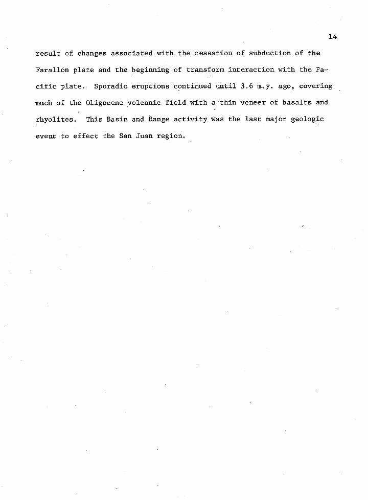
result of changes associated with the cessation of subduction of the Farallon plate and the beginning of transform interaction with the Pacific plateo Sporadic eruptions continued until 3„6 m.yo ago, covering much of the Oligocene volcanic field with a thin veneer of basalts and rhyoliteso This Basin and Range activity was the last major geologic event to effect the San Juan region.
CHAPTER III
DISTRICT GEOLOGIC COLUMN
Regional geologic, history establishes the background for the district's geologic column, to be considered here with emphasis on its role in control of ore deposition. This chapter is organized according to rock formations and associated calderas of development. An interim eruptive period cannot definitively be linked to any distinct caldera, but all other volcanic formations have been correlated with specific calderas. Two comprehensive studies have been made of Creede district geology. Emmons and Larsen (1923) provided a classic review of early production, geography, and general geology with keen observations and insights into overall district ore genesis. Steven and Ratte (1965) assimilated data from four decades of mining and applied newly developed ideas on subaerial volcanism and ore genesis. After a remapping of the district, Stevens and Ratte abandoned Emmons and Larsen's terminology, redefining the stratigraphic nomenclature. Stratigraphic definitions are continually being reviewed and minor changes have been made since 1965. The most comprehensive recent review is the Creede quadrangle geologic map by Steven and Ratte (1973). Age dates reported herein are from numerous sources which have been reviewed by Steven and Lipman (1976) and Bethke et al. (1976).
oApproximately 8,000 knr of rock, exposed in the immediate Creede district, were formed within a 1.4 m.y. period in mid-Oligocene time
15
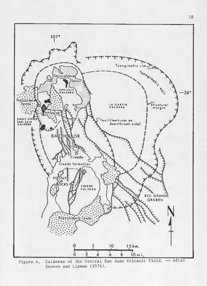
16from 27.8 to 26.4 m.y. ago. Twelve volcanic formations and four major known calderas are exposed in the district (Table 29 Figure 4).
La Garita Caldera The earliest caldera was the La Garita caldera (Figure 4). It
oformed as a result of the eruption of more than 23000 km of Fish Canyon and La Garita tuffs at 27.8 m.y. ago, and the units formed were phenocryst-rich crystal ash flow tuffs of quartz latite composition.The collapse structure, measuring 40-48 km in diameter, was followed by resurgence which domed the caldera core. The southwest side of the caldera has been obliterated by later volcanism and younger caldera formation.
Bachelor Mountain Caldera Eruptive units associated with the Bachelor Mountain caldera
host more than 80% of the mineralization in the district. This caldera became active during the waning stages of formation of the La Garita caldera, as evidenced by intertonguing of the Willow Creek lithology of the Bachelor Mountain Formation with the Phoenix Park member of the La Garita formation near the east side of the district. The Bachelor Mountain caldera, centered on the west flank of the La Garita collapse fault, is not nearly as well preserved as the La Garita. The far- reaching Carpenter Ridge tuff was expelled from the Bachelor Mountain caldera. It has not been dated, but is sandwiched between rocks with 27.8 and 26.7 m.y. dates.
Table 2. Geologic Coltmm. — General geographic distribution of formations are illustrated by the abscissa and age of formation on the ordinate. The vertical bars denote relative duration of
Tgs La Garita Tuff (intracaldera facies of Fish Canyon Tuff) Tfg-Fish Canyon Tuff Tgo-Outlet Tunnel
Lithology of Tg _________ (27.8 m.y.)
18
107'
T o p o g r o phi c r i m
l / i t rocoldero
ova*
S A N L U I S C A L D E R A
PoiCgaJde/ .kpyps,*1'. T̂tructuro I m a r g i n
L A G A R I T A C A L D E R A
lofrpVi Vf'EARLY STA Fau l t (hachure* on
downthrown side)S A N L U I SC A L D E R A
Cr ee de F o r m a t i o n
■fcNT
OF OCKS
C R E E D E C A L D E R A
RIO GRANDE GRABEN NI LW P<>4><?̂l1cGer9''fox,crs'‘ ■’«iy
38 "
10 15 km.- H8 10 m i .
Figure 4. Calderas of the Central San Juan Volcanic Field Steven and Lipman (1976).
After
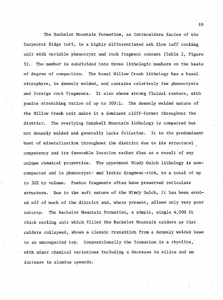
19The Bachelor Mountain Formation, an intracaldera facies of the
Carpenter Ridge tuff, is a highly differentiated ash flow tuff cooling unit with variable phenocryst and rock fragment content (Table 2, Figure 5). The member is subdivided into three lithologic members on the basis of degree of compaction. The basal Willow Creek lithology has a basal vitrophyre, is densely welded, and contains relatively few phenocrysts and foreign rock fragments. It also shows strong fluidal texture, with pumice stretching ratios of up to 300:1. The densely welded nature of the Willow Creek unit makes it a dominant cliff-former throughout the district. The overlying Campbell Mountain lithology is compacted but not densely welded and generally lacks foliation. It is the predominant host of mineralization throughout the district due to its structural competency and its favorable location rather than as a result of any unique chemical properties. The uppermost Windy Gulch lithology is noncompacted and is phenocryst- and lithic fragment-rich, to a total of up to 30% by volume. Pumice fragments often have preserved reticulate structure. Due to the soft nature of the Windy Gulch, it has been eroded off of much of the district and, where present, allows only very poor outcrop. The Bachelor Mountain Formation, a simple, single 4,000 ft ,thick cooling unit which filled the Bachelor Mountain caldera as that caldera collapsed, shows a classic transition from a densely welded base to an uncompacted top. Compositionally the formation is a rhyolite, with minor chemical variations including a decrease in silica and an increase in alumina upwards.
o'
1000-
2000 '-
3 0 0 0 ' -
40 00 '
I%c=0<ZZa»—
tTTmTrrf
W I N D Y GULCH T bw g : noncompocled, unwelded
pumiceous
CAMPBELL M O U N T A I N T b c : compacted, p a r t i a l l y welded, eu taxi t ic texture
W I L L O W CREEK Tbw: densely welded, f l u idal tex ture
J vi t r ophy re
2.2 2.3 2.4 2.5 2.6
Tbwg
Tbc
Tbw
BULK DENSI TY (gm/cmS)
C H E M I C A L A N A L Y S I S
S i 0 2 A I2O3 Fe203 FeO M g O CoO N o20 k 2 o h 2o + H20 ~ T i0 2 P2O5 M nO C 0 2 F Cl T O T A L
Figure 5. Details of the Bachelor Mountain Member. — Data from Ratte and Steven (1967).
21Shortly after deposition of the tuff and collapse of the Bache
lor Mountain caldera, resurgence resulted in the formation of a keystone graben along the crest of the resurgent core. Many of the faults which were developed by this resurgence were later reactivated during mineralization. A barren silicified breccia fills these faults. Dip-slip displacement along these faults was as much as 500 m (Steven and Ratte, 1965).
Interim Eruptive PeriodFollowing the Bachelor Mountain caldera collapse was an interim
eruptive period which is evidenced by several rock formations that cannot definitively be linked to any caldera source. The first of this activity resulted in the deposition of the Mammoth Mountain tuff 26.7 m.y. ago (Table 2). The source of this formation has been obliterated by later volcanism. The formation grades upwards from a rhyolitic, phenocryst-deficient tuff to a quartz latite with abundant phenocrysts. The lower rhyolitic units dip 5-25° to the northeast while the upper quartz latites are flat, indicating structural adjustment during deposition perhaps related to an unknown caldera collapse. The Wasson Park formation succeeded the eruption of Mammoth Mountain, and it is also a phenocryst-rich rhyolite. Its silica content of 68.5% is less than the average Mammoth Mountain and Bachelor Mountain Formations, but is more than that of the uppermost portion of the Mammoth Mountain Formation. There is no evidence for the location of the source area of the Wasson Park formation. A thin veneer of Wasson Park rocks overlies the western half of this study area. A few, low-volume, sporadic, scattered
22eruptions occurred after the Wasson Park formation. Quartz latitic flows erupted along the northwestern third of the district were accompanied by small dacitic to andesitic lavas and flow breccias erupting along the western margins of the district.
San Luis Caldera The San Luis caldera was the third and next major collapse
structure (Table 2, Figure 4). The Rat Creek tuff, the precursor to San Luis collapse, grades upward from a phehocryst-poor rhyolite to a phenocryst-rich quartz latite. The intracaldera facies of the Rat Creek tuff has been largely altered to chlorite. This chloritic alteration is not related to any known mineralizing events. The eruption of the Nelson Mountain tuff was concurrent with resurgence of the San Luis caldera.The tuff is a quartz latite with abundant phenocrysts. Resurgence of the San Luis caldera extended northward, reactivated some of the faults
of the Bachelor Mountain caldera, and created a new set of east-west
faults along its southern margin which would later be mineralized.
Creede Caldera
The fourth and last major caldera subsidence, that of the Creede caldera itself, occurred concurrently with the eruption of the Snowshoe Mountain quartz latite. There was no substantial outflow facies associated with this volatile-deficient eruption. Subsidence, as evidenced by the thickness of the Snowshoe Mountain quartz latite, was more than 1.5 km. Resurgent doming and subsidence tilted the flanks up to 40° and created a north-northwest trending graben along the crest of the core
23
toward the San Luis caldera (Figure 4). The margin's of the Creede cal- dera were the site of many rhyolite to quartz latite eruptions. Included in this are the Fisher quartz latite at 26.4 ± 0.6 m.y. ago, denoted as post-caldera lavas on Figure 4, and the Point of Rocks volcano. Concurrent with these eruptions was the deposition of the sedimentary Creede formation in the arcuate Creede caldera moat. This formation consists of fluvial and lacustrine sediments, interbedded ash beds from the Fisher volcanoes, and irregular travertine deposits. A fanglomeratic facies of this formation originates on the southern margin of the study area.
CHAPTER IV
STRUCTURAL CHARACTERISTICS
Structural characteristics in the Creede district show many of the classic features of an epithermal system at different scales. An extensional regime has been dominant throughout the region's geologic history. Classic cymoid loops, warped fault planes, anastomosing veins, and multiple periods of movement along the same structure are all common features in this system.
District Scale Structures Structures on a district-wide scale originate from events asso
ciated with volcanic eruptions and exhibit episodic reactivation of early structural weaknesses. Much of the early structural movement has been obliterated by later volcanic events. The earliest movement in the Creede district revealed in the exposed rocks is ring faulting associated with the La Garita caldera collapse in the central portion of the district. Following and spatially coincident with this early ring faulting was a period of resurgence and the formation of the keystone graben associated with the Bachelor Mountain caldera. Reactivation of these structures may have occurred with the eruptions of the Mammoth Mountain and Wasson Park formations. Cessation of major movement in the central part of the district was followed by movement in the northern part of the district associated with the San Luis caldera events and in the southern part of the district by Creede caldera activity. All of
24
25the above movements predate mineralization. Hydrothermal activity during these events includes silicification and potassium metasomatism associated with the Bachelor Mountain caldera and chloritization associated with the San Luis caldera. These early structural adjustments account for the majority of the actual displacement in the district.
Preceding and concurrent with mineralization was another vein- forming structural disruption. This period was the result of translational and tehsional forces which reactivated four major subparallel fault zones but caused only minor displacement; resulting veins are named., from west to east, the Alpha-Corsair, the Bulldog, the Amethyst, and the Solomon-Holy Moses (Figure 6). These faults were filled by the major veins of the district. They closely mirrored the earlier structural weaknesses, but at places deviate from them by as much as 300 ft.The bulk of production has come from the Amethyst and two related hanging wall faults, the OH and the P, in the Emperius mines.
Mine Scale StructuresCloser inspection of structures at mine scale reveals features
which were important in localizing ore (Figure 7). The Amethyst fault is the most significant structural feature in the Emperius mine. Stress . and strain along this structure must have been initiated while the Willow Creek lithology was somewhat plastic, as evidenced by observable steepening of foliation and bedding planes with proximity to the fault. This relationship is exposed on the surface at the Commodore 5 and Amethyst 5 addits, where the Willow Creek foliation steepens from a subhorizontal, district-wide orientation to steeply dipping near the
) 26
SKYl !NE
. C O N T I N E N T A L
TfI r e'bw,
T b g w'The
T ! T,cT rc
\Tbc\T b w g Tw
Tbc TwTwT b c ■
j T b w g 'TheT b w
T b wTbc Tbc
/ TbwTbw
Tbc [Tm
T b w
Tbc X,'CREEDS
OBLIQUE PROJECTION
Tw,T bwg TwJ w / 1 T wT b o J be.Tb w gTbc bwT b wTbwg
TbcT b cT b c
T b wTbw T b w Tbw Tgo Tgo
BULLDOG AMETHYST SOLOMON-HOLY MOSESALPHA CORSAIR
CROSS S E C T IO NM i l e s ( N o v e r t i c o l e x o g e r o t i o n )
0 _ 1 Km
Figure 6. District Bedrock Geology. — Overlays photo in Figure 1.
27
S^JrHysr
Figure 7. Major Structures of the Emperius Mine.
Amethyst fault, with no observable faults interrupting the transition. Dip-siip of this normal fault is at least 1400 ft (500 m), the minimum displacement needed to account for the absence of the Willow Creek bed on the hanging wall of the fault on the Commodore 5 level (elevation 9,225 ft, 2,814 m). The fault is sinuous in plan and curviplanar in section. The average strike of the fault plane is N20°W with an average dip of 60°SW. It has a total strike length of approximately seven miles. Beyond the reach of Figure 7, the south end bends sharply to the southeast and dissipates in a mass of horsetail fracturing near the junction of East and West Willow Creeks. The northern half of the Amethyst fault outcrop is obscured by glacial debris. Limited prospecting along this northern trend has revealed the anastomosing of the main fault.
Major hanging wall splits occur at changes in strike and dip of the Amethyst fault. The two most significant hanging wall splits, the OH and P veins, originate at bends in the Amethyst fault (Figure 7).The OH vein extends for over 3,000 ft (915 m) northwest from this bend, striking 15° off vertical. Many smaller veins are similarly concentrated at these bends. The most pronounced bend in the Amethyst fault occurs near the location of the Last Chance mine. On surface, strike deviates from N25°W south of this shaft to due north beside it and then within 2,000 ft (610 m) gradually bends back to a strike of N20oW. On the Commodore 5 level, 1,400 ft (427 m) beneath the surface, the Amethyst fault is nearly planar, striking N25°W and dipping 65°SW. This pronounced bend in strike is accompanied by a roll in the dip of the Amethyst fault. North of the bend, the Amethyst fault dips 55-60°SW.
29The dip steepens 10-15° south of the bendo As a result of movement along this warped fault plane, drag opened subsidiary hanging wall fractures including the major OH and P veins0 Only minor displacement is evidenced across these hanging wall fractures, comparisons having been based on similar lithologies and degrees of compaction because of the lack of any key marker beds. Some minor rotation of blocks appears to have occurred but cannot be detailed due to the scarcity of foliation.
An economically important dense zone of small complex fractures extends several hundred feet into the hanging wall north of the bend in the Amethyst fault where the OH converges into it. This fracturing includes ones which are antithetic, vertical, and sub-parallel to the main Amethyst fault. These fractures are controlling factors at different scales in the occurrence of both disseminated and vein mineralization. Displacement across these fractures appears to be negligible. Complexity and abundance of this hanging wall fracturing decreases with depth. There are markedly fewer, generally wider, more planar and more persistent fractures at depth on the Commodore 5 level 645 ft (200 m) below the Amethyst 5 level. The trend of this densely fractured zone parallels the rake of the intersection of the Amethyst and OH faults, plunging to the north.
Only minor movement post-dated mineralization, as evidenced by the uncrushed nature of most of the ore and the pristine open spaces that remain in some of the breccia zones associated with major veins.One accessible open space on the P vein is large enough for a person to crawl into, the walls being coated by euhedral galena and sphalerite
crystals. Some areas do show delicate open-space textured veins crosscutting veins which show minor crushing, indicating ongoing movement during mineralization. No variations in orientation of early veins with respect to late veins were distinguished, indicating that stress directions were fairly constant, throughout the period of mineralization. A few localities along the Amethyst vein do show minor post-mineral displacement which may be a result of adjustments associated with the Rio Grande graben.
CHAPTER V
MINERALIZATION
The nature of mineralization can be considered within the frame
work provided by the regional geologic history, district geologic col
umn, and structural characteristics. After remarks on district-wide
characteristics, age of mineralization, and methods used to solve the
problems associated with this mineralization, the morphology, spatial relations, and temporal relations of both vein and disseminated mineral
ization will be described.
General Characteristics Many distinguished scientists have contributed to the present
understanding of the characteristics of mineralization in the Creede district (Emmons and Larsen, 1923; Steven and Ratte, 1965; Bethke and Barton, 1971; Barton, Bethke, and Roedder, 1977; Bethke and Rye, 1979). Silver, lead, zinc, and copper, in order of decreasing production value, have been the dominant metals produced from the Creede district. The district is strongly zoned both laterally (north-south) and vertically (Figure 8). The Amethyst-OH convergence area where this study was made occurs at the transition between four zones of mineralization and is the only accessible exposure of the newly discovered disseminated mineralization. The north and deeper mineralization consists of galena, sphalerite, chalcopyrite, and tetrahedrite-tennantite series with chlorite as the dominant gangue. The south and upper mineralization is
31
SOUTH NORTHA m e f h y i t - O H C o nve rg e n ce A r e o
11,500
SURFACE
5,000
DIA G RA M MA T IC LONG SECTION
ASSEMBLAGE □ i l l i t e
Bose metal lu lf ides.aconthite ,quartz
Bose metal sulfides, sulfosolts, chlorite
N at ive silver, sulfosolts,barite, rhodochrosite
Figure 8. District Mineral Zoning
u>to
33composed of native silver, rhodochrosite, barite, and several sulfosalt minerals. A central zone defined in the course of this study consists of base metal sulfides, acanthite, and quartz. A manto zone of extensive illitic alteration caps the mineralization in the northern two- thirds of the district, but essentially fresh rock overlies the entire mineralized system. These assemblages will be discussed in greater detail in the section on vein mineralization. The disseminated mineralization, while most accessible in the Amethyst-OH convergence area, may occur in other as yet undiscovered areas in the district.
Age of Mineralization The age of mineralization in the Creede district is well known
from both direct geologic evidence and radiometric age dating. Direct geologic evidence indicates that mineralization post-dates the last known igneous activity of the Fisher quartz latite. Several strongly mineralized faults crosscut the Creede formation, which is interbedded elsewhere with Fisher quartz latite. Ore in these faults is not appreciably crushed; mineralization was after the faulting which, in turn, post-dates the Creede and Fisher formations. Mineralization has been dated at 24.6 ± 0.3 m.y. ago by K-Ar dating of four samples of vein adularia and sericite. This leaves a 1.8 ±0.9 m.y. gap between the Fisher quartz latite at 26.4 ± 0.6 m.y. and the mineralization. There may be younger Fisher lavas exposed which have not been dated. A U. S. Geological Survey study is in progress to refine the age of the Fisher event.
Methods of AnalysisThe nature of mineralization in the study area became an inter
esting unknown when recent detailed sampling revealed that substantial "invisible" mineralization was present between megascopic vein structures at Creede. Definition of this mineralization was the central task of this thesis. Detailed mapping and sampling of selected crosscuts was performed to discern megascopic relations which might reveal the nature of this mineralization. Vein mineralization was described and assemblages determined in this field portion of the study. From this mapping, it was determined that fine-grained, megascopically inconspicuous mineralization not related to the major veins did occur and that a miner- alogic study was required to determine the nature and distribution of this mineralization.
Several techniques were used to determine pertinent mineralogic variations. The primary means of data collection were reflected light ore microscopy, elemental mapping with a scanning electron microprobe quantometer, and quantitative microprobe analysis. Transmitted light microscopy, x-ray diffraction, heavy mineral separation, and staining for both potassium feldspars and clay determination was used to supplement the above data. Reflected light ore microscopy was essential in determining ore mineralogic variations, textural features, and para- genetic relations, particularly for the disseminated mineralization. Variations and relations were documented by drawings and photographs which were also used to record the locations of microprobe analyses.This microscopic study identified the presence of fine-grained
disseminated sulfides as the probable host of the mineralization in hand specimense More sophisticated techniques were needed to determine the distribution of silver itself. A scanning electron microprobe quantometer was employed to define the mineralogic distribution of silver « Simply puts this instrument focuses a ten-micron diameter beam of
. ' '' ' xelectrons onto a highly polished, electrically grounded sample and measures resulting secondary x-rays generated by the electron bombardment which are characteristic of the elemental composition of the sample0 This tool was used in two ways. It was used to analyze specific minerals for their silver.content; unless otherwise noted, all elemental compositions reported here are from analysis performed with the microprobe. The microprobe was also used to map the distribution of particular elements in specific mineral grains. Photographs were taken of some of these raster-scan elemental maps to document these distributions. The instrument used was an Applied Research Laboratories Scanning Electron Microprobe Quantometer at The University of Arizona, with a detection limit of approximately 0.02% Ag. This limit is equivalent to 5.82 troy ounces per short ton, or 200 ppm. A substantial problem may exist if
Vundetected silver values are disseminated in low abundances through several minerals.
In a deposit where one ounce per ton may be the difference between profit or loss, the potential problem of this insensitivity to low abundances required some cross-checking. In order to determine the magnitude of the potential problem, comparison between whole-frock silver analyses and analyses of the mineralogic components in four rocks was
made (Table 3)» Fire assay was used to determine the abundance of silver in the whole rocko Polished sections were made from carefully chosen splits of the assayed rocks„ Ore petrology was employed to determine abundances of minerals present, and microprobe analysis was used to determine the concentration of silver in these sulfides. The samples were then ground to -200 mesh, and heavy mineral separation was* employed to define the weight abundance of the heavy minerals in it. Calculations based on the abundance of the sulfides in the whole rock, the relative abundance of each sulfide, and the silver content of each sulfide con
firmed that the budget was complete and that the microprobe was detected the significant silver-bearing phases present. Four samples yielded similar results (Table 3). In other words, the 200 ppm detection limit of the microprobe did not pose a problem in identifying silver distribution either qualitatively or quantitatively, all but an insignificant percentage occurring at levels of 0.02% Ag or above.
Vein Mineralization Vein mineralization discussed in this section is presented under
four headings: morphology, mineralogy, zoning, and paragenesis. Thefirst two topics, morphology and mineralogy, present observable features of the vein mineralization exposed in the study area. The final two topics, zoning arid paragenesis, synthesize the data presented in the first sections as an interpretive discussion on spatial and temporal relations.
37
Table 3. Comparison of Whole Rock Fire Assay and Microprobe Analysis of Mineral Constituents.
Veins in the study area exhibit many characteristics typical of1 . •
an epithermal system. They reach thicknesses of up to 15 ft and arevariable in orientation. The Amethyst vein is the only vein which may be traced along dip and strike throughout the Amethyst—OH convergence study area, because it is the only vein which occupies a fault that displaced distinctly different rock types. None of the hanging wall veins exhibit the persistence necessary-to permit tracing singular veins, either laterally or vertically throughout the study area. A stoped area on the Chance 2 (Figure 9) is typical of the complexity of vein strike orientation in plan at one locale. Although they are planar overall, a single vein may be seen in detail to split, crosscut itself, then rejoin itself or another vein. Similarly, vein patterns are complex in section, as can be seen in many of the large stoped areas. Figure 10 shows a sectional veiw drawn from a series of photographs of a stope face on the P & E 60 level. Due to this variability, singular ore shoots were generally not named during mining. When veins were named, different veins on different levels were apt to be given the same name and the same vein might be given different names in various places. Veins are more persistent, more planar, somewhat thicker, and less abundant deeper . in the study area. The vein-wall rock contact is generally knife-sharp (Figure 11). When disseminated mineralization is not present, the vein contact is an abrupt grade cutoff.
Vein Strike Complexities. — From the northern crosscut on the Chance 2 level. All veins shown are greater than two inches thick.
rESTEAST
W A L L R O C K
WALLROCK
W A L L R O C K
Figure 10. Vein Dip Complexities. — This cross section is drawn from a series of photographs of a mine face on the P & E 60 level. Orientation of the section is within ten degrees of perpendicular to vein strike so the apparent dip shown is equivalent to true dip. The bottom of the section is ten feet across.
41
Figure 11. Wall Rock Vein Contact. — Note sharpness of the contact.This vein assays more than 100 oz/ton (3400 ppm) Ag (penny included for scale).
42wall-rock surfaces, sharp wall-rock contacts, euhedrally terminated crystals pointing toward vein center lines, coarse euhedral crystals, even open spaces which have not been filled— all of these traits clearly indicate the domination of open space filling in vein mineralization.Some replacement textures have also been observed, but they are sparse.
MineralogyNine vein mineral assemblages were defined in the course of this
study (Table 4). These assemblages represent the mineralogic distributions from three mineralizing phenomena: hypogene spatial variations,hypogene temporal variations, and supergene overprinting of hypogene events. The assemblages were classified in the field as an aid in mapping important relations which they reflect. After discussing each of the vein assemblages, their spatial and temporal relations will be presented. In general. Assemblages I and II appear supergene; III may be high-level hypogene; IV is the principal hypogene vein filling; V, VI, VII, and IX are variant vein fillings; and VIII is a wall-rock alteration assemblage.
Assemblage I. Assemblage I (Table 4) is restricted to the upper portions of the mine, with distinctly increased abundance in the extreme uppermost levels. Below the P & E level at 10,070 ft (306 m) elevation, these minerals are uncommon and are generally only seen coating mine walls. Minerals of this assemblage occur as open-space coatings in fractured or vuggy zones in earlier vein assemblages. Leached cavities are common features associated with this assemblage. It occurs as an
V 43Table 4. Vein Mineral Assemblages«AssemblageNumber Vein Minerals
Alteration Minerals'
I native silvernative copperanglesiteemboiite-bromyritenative sulfurcerrusitehematitegoethitejarositeoxide coppers including: brochantite azurite
kaolin halloysite other clays
II
III
manganese oxide group including: hollandite cryptomelane
kaolin quartz other clays
alunitequartz
IV chalcocite acanthite native silver pyrite galena sphalerite chalcopyr it e greenockite
kaolinillitequartz (minor chlorite)
V native silver undetermined sulphosalts
quartzbariterhodochrosite
VI "gel" pyriteVII quartzVIII minor pyrite quartz ,
illite
IX pyritegalenasphaleriteehalcopyritetetrahedrite-tehriantite series
chlorite quartz \
44irregular overprinting of Assemblages IV, V, VI, and IX and appears to be part of supergene oxidation of both pre- and post-mine age. Commonly, detailed examination of a vein reveals primary mineralogy, though supergene effects occasionally eradicate previous mineralogy beyond distinction, leaving only the quartz component of the earlier assemblage unaffected.
Clays are volumetrically the most significant component of this assemblage. X-ray diffraction studies reveal kablinite most common. Morphologically distinct halloysite was also identified; it has a hard and waxy appearance when dry, and it gels when moistened. Other clays may occur, but were not identified. The impure and fine-grained nature of these clays requires a major study to define exact clay mineralogy.An x-ray diffraction study by the U. S. Geological Survey under the direction of P. Bethke to detail variations in clay mineralogy throughout the district is presently underway.
An attempt was made to refine the determination of clay types in the field. It was hoped that clay variations might be useful for interpreting supergene versus hypogene assemblages. Benzidine, safranine Y, and malachite green staining techniques (Mielenz, King, and Schiettz, 1950) were applied unsuccessfully. The results were too subtle to be effective when applied to illite, kablinite, and .halloysite.
A complex assemblage of metal-bearing minerals occurs in this group. Silver is present in the native state in alloy with native copper up to 8.43% Ag, in anglesite up to 0.43% Ag, and in some of the copper oxides up to 0.78% Ag. The copper oxides are volumetrically
insignificant and were not studied in detail. Native silver, copper, and even native sulfur are present in these highly oxidized veins.Leaf silver was commonly found coating fractures in pods of halloysite. Anglesite, cerrusite, hematite, jarosite, goethite, and a variety of copper oxide minerals were commonly seen rimming cores of base metal sulfides. Embolite-bromyrite series minerals were detected with the microprobe in two specimens of leached, vuggy barite. These halogen salts were very fine-grained at less than 20 microns in diameter, so x-ray diffraction confirmation was not possible.
Assemblage I is of probable supergene origin. Supporting evidence for this includes the mineralogy of assemblage, the leached nature of texturally older mineralization, the rimming replacement, its zonal position, its concentration in fractured, vuggy veins, and its similarities with post-mine wall coatings.
Assemblage II. A Complex variety of manganese oxide minerals dominates Assemblage II. It occurs only in the upper levels, above the Amethyst 5 level, is concentrated in a zone within 100 ft of the Amethyst vein, and is most abundant in the southern third of the study area. It occurs permeating breccia zones up to 50 ft wide and in distinct veins. The breccia zones contain from 10 to 50% matrix composed of approximately 35 volume percent intimately, intergrown clays, 10 volume percent quartz, and 55 volume percent manganese minerals. The rock fragments in these breccias are generally fresh with some minor bleaching or clay alteration. Vein composition is similar to the breccia matrix, but
occasionally has 80 volume percent quartz» The only clay mineral positively identified was kaolin, but other clay minerals may be present. Powder camera x-ray diffraction was the primary tool for determining the mineralogy of the manganese minerals. This assemblage is complex, and an exhaustive study was not possible. - Due to the delicate structure of many manganese minerals, care was taken to avoid excessive grinding when preparing samples for powder x-ray mounts. Cryptomelane (KMgO-^)
and hollandite (BaMngO^g) were definitively identified, and other manganese minerals may occur. Silver and base metals are present up to 1.53% Ag through most of the manganese mineral ̂assemblages.
Assemblage II is of probable supergene origin. It appears to result from the destruction of Assemblage V, as indicated by the position of Assemblage II overlapping Assemblage V and the occasional occurrence of rimming replacement of rhodochrosite by manganese minerals.
Assemblage III. This comparatively rare assemblage of alunite) - plus quartz was identified in only three locations on the Sloan and
Amethyst 5 levels, where alternating alunite and quartz bands occur inveins up to 4 inches wide. An Assemblage 111 vein on the. Sloan levelcrosscuts earlier quartz veins and is itself crosscut by later quartzveining, relations indicating probable hypogene origin. Although itsrelative rarity hinders determination of its origin, this assemblagemay have implications in terms of modeling of the hydro thermal system.Alunite is a mineral not previously identified in the Creede district.No silver has been identified in this assemblage.
47Assemblage IV, The majority of vein mineralization in the upper
levels of the study area is constituted by this mineral assemblage of quartz with lesser amounts of clay and minor amounts of pyrite, galena, sphalerite, chalcopyrite, acanthite, covellite, chalcocite, and green- ockite, and occasionally trace amounts of chlorite (Figure 8). The many varieties of quartz in this assemblage include very fine-grained, white- to-translucent chalcedony, euhedral, coarsely crystalline amethystine quartz and white quartz crystals up to 4 cm in diameter, jasper, and quartz with a waxy green luster. This "green quartz" in. many epithermal districts is known as a pathfinder mineral indicating close proximity to ore, and it is so in the Creede district. The cause of this coloration is unknown. No apparent mineral inclusions occur within it, and no chemical impurities were detected with the microprobe. While the presence of green quartz does indicate close proximity to ore, the absence of green quartz does not preclude the occurrence of ore. None of the other varieties of quartz are either positive or negative proximity indicators.
Clay minerals in this assemblage, include kaolinite and.illite Exact abundances and kaolinite-illite ratios were not determined. Theoccurrence of illite may indicate a hypogene source for thismineralization..
Silver occurs in this assemblage in many mineral phases. Native silver is present in acanthite (x = 75.25% Ag), covellite (x = 0.47% Ag), chalcocite (x =0.36% Ag), chalcopyrite (x = 0.24% Ag), and galena (x =0.01% Ag). These minerals generally occur as 1-30 mm bands of
coarse-grained mineralization interbanded with quartz. Figure 12 shows feathering acanthite bands in a chalcedonic quartz vein. Galena is the most common sulfide constituent, but the majority of the silver is related to acanthite and native silver phases. Greenockite was noted in one sample from the ,P & E 150 level; x-ray diffraction confirmed its identification. Often a single vein traced over distances of less than 50 ft will have a variety of sulfide mineral phases present, but seldom do the different phases occur in contact with one another. Paragenesis within this assemblage was not distinct due to the scarcity of contact relations between the minerals present and due to the overprinting of Assemblage I.
Assemblage V. Assemblage V consists of native silver, barite, rhodochrosite, and quartz. It is most common in the southern third of the district and occurs in minor amounts on the southern fringe of the Amethyst-OE convergence area (Figure 8). Replacement of this assemblage by Assemblage II is seen in several places, suggesting that Assemblage II probably resulted from supergene replacement of this assemblage. Quartz pseudomorphs of barite commonly envelop veins of Assemblages IV or VII. Euhedral barite crystal form is well preserved in quartz, allowing no doubt of its replacement origin. Native silver occurs as fine wires in vugs in both barite and quartz.
Assemblage VI. Assemblage VI consists entirely of coarsegrained botryoidal pyrite. This assemblage occurs in the Amethyst—OH convergence area above the P & E 150 level. It has not been observed
49
Figure 12. Dark Acanthite in Quartz Vein Material. — Note the anastomosing texture of acanthite interbanded with chalcedonic quartz (penny included for scale).
50south of the study area, but is reported to the north in the upper workings along the OH and P veins. No silver occurs with this assemblage. Botryoidal pyrite appears to be a late-stage event; no assemblage has been seen crosscutting it, and it crosscuts every assemblage associated in space with it. The orientation of veins filled with this assemblage is indistinct from that of any other assemblage.
Assemblage VII. Quartz is the only component of this assemblage. It occurs as a component of other assemblages throughout the Creede district, but appears to be a distinct assemblage only above the Amethyst 5 level in the study area. It may represent a metal-deficient period or zone of Assemblage IV mineralization. This "quartz-only" assemblage is warranted because of the common occurrence of quartz as the sole constituent of certain veins in the study area. No paragenetic relationship with other assemblages could be defined. In some occurrences, "quartz-only" veins are crosscut by others of the same type, indicating that it is a recurrent assemblage.
Assemblage VIII. Assemblage VIII consists of illite with minor amounts of fine-grained quartz and trace amounts of pyrite. Distribution of this assemblage is restricted to veins above the Amethyst 5 level and is more prominent along the western edge of the study area.This assemblage comprises the most conspicuous and abundant form of wall-rock alteration present in the district (Figure 8). It will be discussed in detail in the section on wall-rock alteration. It has
51
been mentioned here because it occurs as vein-filling as well as wall- rock alteration.
Assemblage IX. Assemblage IX occurs throughout the northern third of the district (Figure 8). It has been described in detail as the primary mineralogy of the OH vein (Bethke and Barton, 1971; Barton et al., 1977). In the Amethyst-OH convergence area, this assemblage is exposed only on the Commodore 5 level. No access exists to the 645 ft vertical interval between the Amethyst 5 level and the Commodore 5 level. Assemblage IX is composed of galena, sphalerite, pyrite, chalcopyrite, and tetrahedrite-tennantite series phases with abundant chlorite and minor amounts of quartz; it is notably silver-poor. Tetrahedrite- tennantite sulfosalt series are the silver-bearing minerals in this assemblage. X-ray patterns showed chlorite to be thuringite, a high Fe, low Mg member of the chlorite mineral group. Anomalous manganese at up to 2.75 wt % (Emmons and Larsen, 1923) is also present.
Zoning and ParagenesisSpatial and temporal relations will be discussed together in
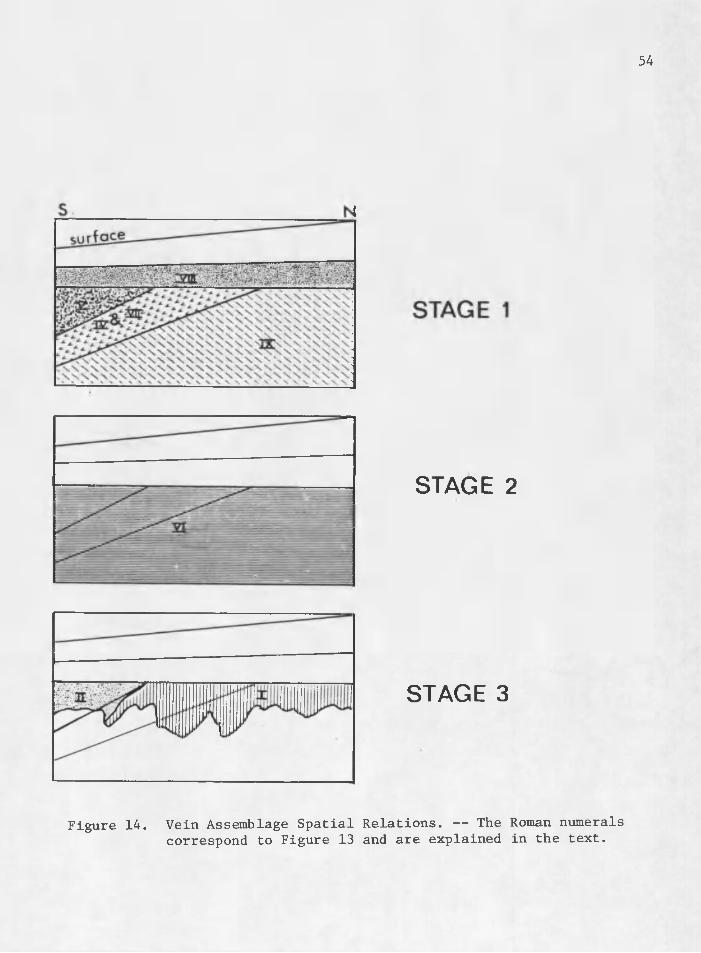
this section to illustrate the concurrent processes involved. Due to lack of either surface or underground exposure, the relationships described below are vague; crucial areas of transition between.hypogene assemblages are not exposed and generally when they are exposed, super- gene processes have obscured primary relationships. Three stages of mineralization have been classified (Figure 13); schematic diagrams of the spatial relations between assemblages for each stage are presented
ASSEMBLAGE EARLY.Stage 1
I - oxidesII - manganese oxides III - alunite, quartzIV - base and precious metal _______ _
53(Figure 14). Stage 1 mineralization consists of the main hypogene event and is composed of illite (VIII) at the top of the system; rhodochrosite, barite, sulfosalts, native silver, and quartz (V) at the south end; base metal sulfides, acanthite, quartz (IV), and "quartz-only?' (VII) assemblages in the middle third; and base metal sulfides, sulfosalts, and chlorite (IX) at the north end of the study area. Stage 2 mineralization is composed predominantly of Assemblage VI, the coarse-grained botryoidal pyrite. The paragenetic position of Assemblage III, alunite with quartz, is vague due to its limited exposure, but the crosscutting relationships of the "quartz-only" assemblage (VII) suggests that Assemblage III belongs in Stage 2 between the major hypogene and supergene events. Stage 3 is the supergene stage, at least partially continuing to form today, as can be seen on mine walls. It is composed of the various oxides, sulfates, salts, carbonates, and native elements in Assemblage I and the manganese oxides and clays of Assemblage II.
Disseminated Mineralization The presence of disseminated mineralization in the Creede dis
trict has not been noted by previous workers, in part because mineralization of this grade has only recently become of economic interest. Due to relatively limited exploration activity for this form of mineralization compared to vein mineralization, its only known Creede district occurrence is in the Amethyst-OH convergence area. Exposure of this "heart" of disseminated mineralization is good, but the north, south, and vertical boundaries are not exposed in the accessible mine workings. Workings do expose the east and west boundaries of the disseminated
54
STAGE 2
STAGE 3
Figure 14. Vein Assemblage Spatial Relations. — The Roman numerals correspond to Figure 13 and are explained in the text.
55mineralization, but the workings stop in intensely altered rock on the west side of the zone, creating uncertainty. Only a small percentage of the system may be exposed in the present workings, a fact which hinders discussion of zoning and of the fringes of the system.
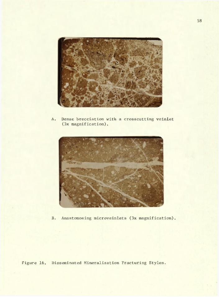
MorphologyDisseminated mineralization occurs in a broad, irregular zone
within which ore-grade material is localized in erratic pods. These pods are erratic in both shape and distribution, and most have gradational fringes, Expectably, the erratic shape becomes more regular and the distribution of pods of ore coalesce as one accepts a lower grade definition for ore, and the total tonnage similarly increases. The distribution and magnitude of this zone of disseminated mineralization can be seen on Figure 15, It appears to plunge to the south and to dip subparallel to the Amethyst fault. The Amethyst fault is the abrupt foot- wall on the east side of this zone, and the irregular hanging wall which - dips slightly shallower than the Amethyst fault is defined by a zone of extensive illite alteration. The bottom is defined by a gradual decrease in the abundance of sulfides, and illite alteration converges across the top of the zone. Surface exposures of the disseminated mineralization are poor and limited to a few small areas exposing illitic alteration and a unique sample with disseminated sulfides found in talus downslope from the mineralized zone. Exposure is limited north and south of the zone, so these boundaries are undefined.
The disseminated mineralization is fine-grained, commonly less than 100 u in diameter. Particles fill microveinlets, rim and fill
56
I S O M E T R I C PROJECTI ON
L E G E N DFAULT
&
f . W
— V — V E I N
I L L I T I C A L T E R A T IO N
SIL IC IFJCA T / O N
\£>ISSEMINATED SULFIDES
Figure 15. Hypothetical Disseminated Mineralization and Alteration Patterns.
57pumice fragments, and fill intergranular pore spaces in volcanic matrix. Closely spaced microfracturing is a key component of this form of mineralization. Dense brecciatibn with later crosscutting veinlets (Figure 16A) and anastomosing microveinlets (Figure 16B) are common features of this microstructural regime.
The only visible evidence of the presence of disseminated mineralization may be the occurrence of jarosite and copper oxides coating mine walls. The relationship is not simple and direct, for significant disseminated mineralization can occur with no dusting of jarosite or copper oxides, but it is a useful guide.
MineralogyA simple group of base and precious metal sulfides is found in
this type of mineralization. Extensive search for sulfosalts in the disseminated mineralization proved fruitless. The ore minerals present include pyrite, galena, chalcopyrite, greenockite, sphalerite, covel- lite, chalcocite, and acanthite; the similarity of this assemblage to Assemblage IV of the vein assemblages is apparent. Gangue consists solely of quartz. Sternbergite was at first thought to be present, but more detailed analysis revealed the suspect grains to be fine-grained acanthite replacing pyrite. Anglesite is present in a few samples, commonly with galena cores still present. Silver occurs in acanthite (average = 75.25% Ag), covellite (average = 0.47% Ag), chalcocite (average = 0.36% Ag), chalcopyrite (average = 0.24% Ag)^ galena (average = 0.01% Ag), and anglesite (average = 0.43% Ag), in order of decreasing abundance within the deposit.
58
A. Dense brecciation with a crosscutting veinlet (3x magnification).
59An intriguing phenomenon became apparent during reconnaissance
with the microprobe when anomalous titanium up to 0.03% Ti02 was detected in several sulfides. Detailed petrographic examination and further microprobe analysis revealed the occurrence of ilmenite as an accessory mineral in the rhyolite. One polished section showed a euhedral quartz crystal with ilmenite blades concentrated along hexagonal growth planes of the quartz crystal and a pyrite grain located at the edge of the quartz. Microprobe analysis revealed anomalous titanium in the pyrite grain. Similarly, sulfides which have replaced early pyrite sometimes contain anomalous titanium. This evidence indicates that some of the pyrite may be a result of sulfurization of primary ilmenite.
Supergene mineralization resulting from weathering of these disseminated sulfides consists predominantly of minor hematite and jarosite lining pyrite molds. As previously mentioned, this supergene mineralization is volumetrically insignificant. A small amount of the covellite, chalcocite, and acanthite may be of supergene origin, but three lines of evidence suggest a hypogene origin for the majority of this mineralization. First, these minerals are the predominant silver-bearing phases; were they supergene, then other silver-bearing hypogene phases should occur. Second, the chalcocite always appears coarse-grained, not the sooty, fine-grained variety to be expected in a supergene environment a This coarse-grained nature of the chalcocite was confirmed by 50% nitric acid etch tests, which revealed the.expected "mud-cracked" pattern.Third, botryoidal chalcocite occurs as thin alternating growth bands with quartz, an unlikely occurrence in a supergene environment.
ZoningDetermination of spatial relations within and at boundaries of
disseminated mineralization is vague because, of three factors: - 1) the fine-grained, inconspicuous nature of this mineralization; 2) limited mine workings in the zone of interest; and 3) muddied mine walls. This mineralization and the economically important silver within it are best located by assay. Figure 17 presents the hypothetical distribution zoning patterns of pyrite, acanthite, galena, and sphalerite interpreted from limited underground exposure, analysis, and microscopy. A few relations may be deduced from these patterns. All of the mineral zones may occur by themselves or with any combination of the other zones. No simple concentric or unidirectional zoning pattern exists. Each zone irregularly partially overprints each other zone with the early pyrite zone most widespread and the late acanthite zone the least widespread.
ParagenesisMany classic paragenetic textures are evident in samples of dis
seminated mineralization. Characteristics used for determination of replacement and for relative age determination are largely those of Edwards (1947). Relationships used for determining successive deposi- . tion include transecting veins, incipient veing when the long dimension is at least four, times the short dimension, and straight crystal boundaries with internal angles of the older mineral less than 180°. Replacement textures used include relict crystal form of pseudomorphed minerals and rim replacement with clear caries "biting" into the older
Figure 17. Disseminated Sulfide Distribution. — The distribution of the disseminated sulfides acanthite, sphalerite, galena, and pyrite. Note the lack of concentric or uni-directional zoning. Pyrite is the most widespread and the later episodes of sphalerite-rgalena and acanthite are progressively less widespread and irregularly overprint the early pyrite.
mineral. Caries were used to add support to a mineral relationship, not as conclusive evidence by themselves.
Paragenetic relations based on detailed polished section studies show both replacement and successive deposition (Figure 18). Four stages of paragenesis can be distinguished on the basis of this study. The A stage, consisting of quartz, was deposited before the sulfides, although minor quartz deposition continued until the end of the mineralization. The 15 stage consists of pyrite which followed quartz and was a precursor to the other sulfides, galena, sphalerite, chalcopyrite, and minor greenockite of the stage. The final I) stage was silver-bearing, consisting of acanthite, covellite, and chalcocite.
Numerous photomicrographs, scanning electron micrographs, and elemental x-ray maps from the microprobe will be used to present the details of these paragenetic relations. Unfortunately, the color quality of the photos is not true to the optical properties of the minerals, so line drawings of the photomicrographs have been included to document the mineral distributions. Euhedral pyrite cubes transected by sphalerite veins are.a common feature (Figure 19). Note unmatched walls indicating replacement where the sphalerite crosscuts the pyrite. Sulfide grains are markedly coarser when they fill pumice fragments as opposed to impregnating interstitial volcanic matrix (Figure 20). Note that the pyrite crystals have been replaced by chalcopyrite and covellite. Covellite replacing both chalcopyrite and pyrite is not apparent on the photo, but is seen in the specimen. Replacement of growth bands in euhedral pyrite cubes by covellite is common (Figure 21). D-stage
Figure 20. Coarser Sulfides in Pumice Fragment. — Chalcopyrite (cp) and covellite (cv) are replacing the early pyrite.
66
CV-
Imm
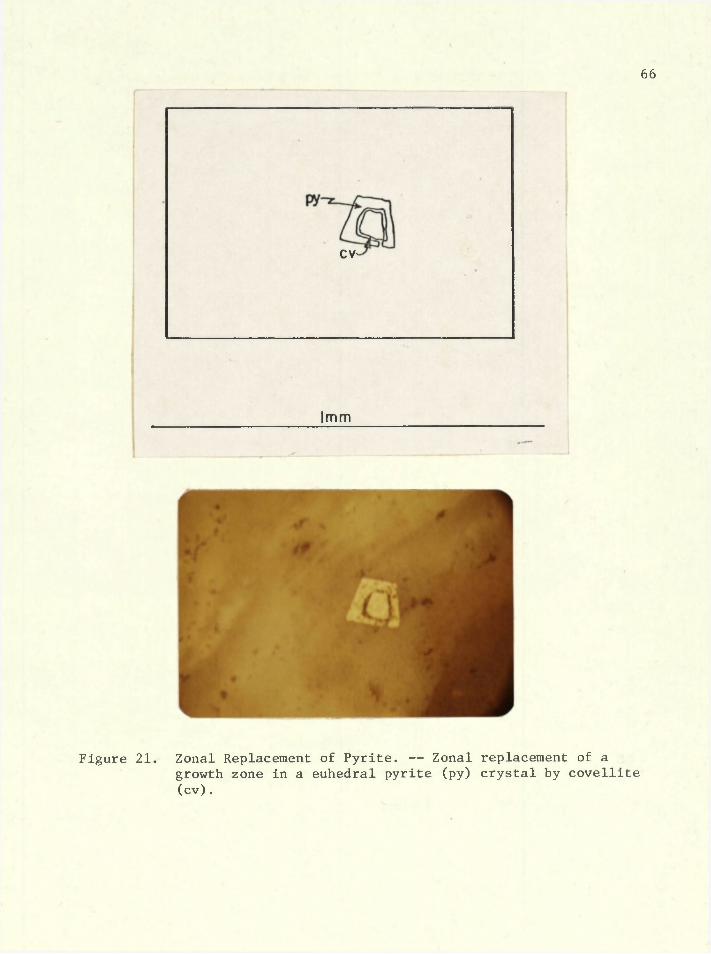
Figure 21. Zonal Replacement of Pyrite. — Zonal replacement of agrowth zone in a euhedral pyrite (py) crystal by covellite (cv) .
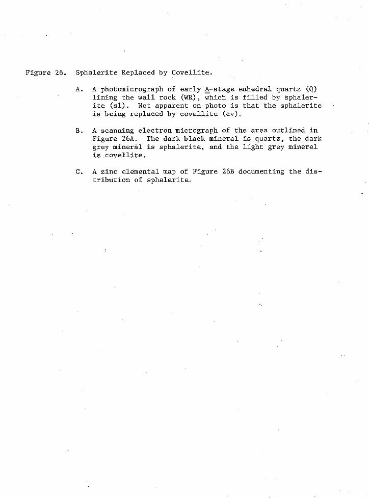
acanthite replacement of B-stage pyrite (Figure 22) is evidenced by vein- ing and caries along pyrite rims. Microprobe elemental maps of an enlarged portion of a grain in the photomicrograph of Figure 22 show iron and silver distributions which document this relationship. A more complex and common relationship involves multiple stages of replacement. Three stages of replacement are apparent in Figure 23, where early B- stage pyrite is replaced via veining by C-stage sphalerite plus chalco- pyrite, with D-stage covellite replacing all of the above. These sequential stages are not readily apparent in the photomicrograph (Figure 23A), but they are documented on the elemental maps which follow (Figure 23C-F)„ Also illustrated on the elemental maps is the occurrence of silver (Figure 23E) in the cdyellite. This relationship can be seen by mentally subtracting the patterns outlined in the iron map (Figure 23D) from the copper map (Figure 23F), separating the chalcopyrite and pyrite distribution from the covellite distribution, and then comparing this to the silver map (Figure 23E). Quantitative microprobe analysis confirms the silver-bearing nature of the covellite. Detection limits for the silver elemental map (Figure 23E) was adjusted so that the higher abundance of silver in the covellite (x = 0.47% Ag) would be detected while the lower abundance of silver in the chalcopyrite (x = 0.24% Ag) would not, in an attempt to illustrate the distribution of covellite. Early-stage euhedral quartz is seen in Figure 24. Also exhibited in this photo is the lack of conclusive age relations between the minerals present, a lack which is more common than not. Age relations between sphalerite and galena commonly show sphalerite
Figure 22. Acanthite Replacing Pyrite.A. A photomicrograph of a pyritized pumice fragment.B. A scanning electron micrograph of the sulfide fragment
marked with an arrow in Figure 22A. The black areas are quartz, the light grey are acanthite, and the medium grey are pyrite.
C. Silver elemental map of Figure 22B illustrating the distribution of acanthite.
D. Iron elemental map of Figure 22B illustrating the distribution of pyrite.
%
C. 0.1 mm
Figure 22. Acanthite Replacing Pyrite.
D. 0.1 mm
Figure 23« Multi-stage Replacement.A. A photomicrograph of a cluster of early B_-stage py-
rite grains variably replaced by later C_~stage chal- copyrite plus sphalerite, with both earlier stages replaced by late _D-stage covellite.
Bo A scanning electron micrograph of the sulfide grain marked with an arrow in Figure 23A. This grain consists of pyrite, sphalerite, chalcopyrite, and covel lite* Their distribution will be apparent in the following elemental maps.
Co Zinc elemental map of Figure 23B documenting the distribution of sphalerite0
Do Iron elemental map of Figure 23B documenting the dis tribution of chalcopyrite and pyrite.
69
Figure 23. Multi-stage Replacement.
Figure 23, Continued.Eo Silver elemental map of Figure 2333 documenting the
distribution of silver-bearing covellite.Fo Copper elemental map of Figure 23B documenting the,
distribution of chalcopyrite and covellite«
\
Figure 23, Continued.
71
CC
lingcv
I mm
Figure 24. Ambiguous Age Relations. — Between galena (gn), sphalerite (si), anglesite (ang), and covellite (cv). The only unequivocal relationship is the early quartz (Q) filling revealed by the euhedral crystals; sphalerite appears to replace galena.
72
crosscutting galena (Figure 25). Also well-illustrated in this photo is the early euhedral quartz filling. Figure 26 shows a veinlet lined with euhedral quartz, which was later filled with sphalerite which has been partially replaced by veining and caried by argentiferous covellite.The zinc elemental map (Figure 26C) illustrates the distribution of sphalerite in the enlarged portion of Figure 26A. The distribution of covellite is seen in the copper elemental map (Figure 27D), and the argentiferous nature of the covellite is documented by thd silver elemental map (Figure 27E), Greenockite is present in microveinlets in Figure 27, which also shows galena crosscutting and corroding sphalerite, a less common relationship than sphalerite replacing galena. This evidence, present in several samples, is the reason for distinguishing two periods of galena mineralization. Note that no conclusive age relations exist between greenockite and the other minerals in this section. Thin alternating bands of botryoidal chalcocite with quartz are evidence of simultaneous deposition (Figure 28). Covellite transects chalcocite (Figure 29), indicating that covellite is somewhat younger than chalcocite. ,
I
Summary and Discussion:Disseminated Mineralization
The overall mineralogy of the disseminated mineralization is essentially the same as that of Assemblage IV of the vein mineralization, indicating a probable contemporaneity of the hydrothermal solutions which precipitated each of these types of mineralization. Further, overall spatial relations reveal that Assemblage IV vein mineralization is roughly coextensive with the zone of disseminated mineralization.
73
Figure 25
hemW R
<WR
mm
¥Sphalerite Replacing Galena. — Sphalerite (si) cutting galena (gn) in a quartz (Q) veinlet. Euhedrally terminated quartz crystals lining the wall rock (WR) and terminating toward the veinlet centerline indicates early-stage, open- space filling of quartz. Supergene hematite (hem) is also seen in this photo.
Figure 26. Sphalerite Replaced by Covellite.A. A photomicrograph of early A-stage euhedral quartz (Q)
lining the wall rock (WR), which is filled by Sphalerite (si). Not apparent on photo is that the sphalerite is being replaced by covellite (cv).
B. A scanning electron micrograph of the area outlined in Figure 26A. The dark black mineral is quartz, the dark grey mineral is sphalerite, and the light grey mineral is covellite.
C. A zinc elemental map of Figure 26B documenting the distribution of sphalerite.
74
figure 26B
0.3 mm B. 0.1 ram
Figure 26. Sphalerite Replaced by Covellite.
Figure 26* Continued.D. A copper elemental map of Figure 26B documenting the
distribution of covellite.E. A silver elemental map of Figure 26B documenting the
argentiferous nature of the covellite.
75
D. 0.1 mm
E. 0.1 mm
Figure 26, Continued.
76
green oc kite
gn
I mm
Figure 27. Greenockite Veinlet. — Veinlet in the center is rimmed by sphalerite (si) which is crosscut by galena (gn) veinlets. A small pyrite (py) cube is present in the volcanic matrix.
77
Q+cc
cc
cc
1mm
Figure 28. Botryoidal Chalcocite Alternating with Quartz. — Botryoidal chalcocite bands alternating with thin quartz bands, togeth-
78
CC
0 .5 mm
Figure 29. Covellite Replacing Chalcocite. — Covellite (cv) microvein- lets crosscutting coarse-grained chalcocite (cc). The covellite may be of exsolution origin, although some of it appears to be texturally young and crosscutting.
more evidence of a genetic tie between these two forms of mineralization* Careful consideration was devoted in the field to defining a possible continuum between the vein mineralization and disseminated miner- mineralization, but no clearcut gradational continuum was found* Distinct veins do not grade into smaller, less distinct veins, which do not grade into vein stockworks, which do not grade into high-density microfractures * which do not grade into grain boundary and pumice fragment fillings* The abundance of disseminated mineralization does not appear to vary proportionally with distance from megascopic veins* Pods of relatively abundant sulfides occur tens of feet from any vein, and barren rock may well intervene. This mappable feature suggests independent detailed controls of main vein and disseminated mineralization, the geologic reasons for which are not understood, but will be hypothesized upon in the summary and synthesis section*
CHAPTER VI
ALTERATION
The best exposures of wall rock alteration in the entire Creede district occur in the Amethyst-OH convergence area. Three types of alteration have been noted throughout the district. The earliest is potassium metasomatism which does not appear to be related to any mineralizing event and will be only briefly discussed here. The second and third types are spatially related to both vein and disseminated mineralization; after a few remarks on their district-wide distribution^ they will be described in detail in terms of their relations to the disseminated mineralization.
The potassium metasomatism was first detected through whole rock chemistry studies (Ratte and Steven9 1967). This alteration introduced K^O and resulted in total K^O values of up to 11%. It is pervasive and district-wide in extent9 occurring throughout much of the Bachelor Mountain rhyolite. No other formations in the district have anomalous K^O contents. The K^O values exhibit a crudely concentric zonation9 centered on the supposed source area of the Bachelor Mountain rhyolite (T. A. Steven/ personal communication, 1979). > There is no significant correlation of K^O values with proximity to mineralization or mineralized structures. A form of deuteric activity may account for this alteration. Anomalous K^O values occur in other subaerial volcanic regions such as the Datil-Mogollon volcanic field in New Mexico (Chapin et al.9 1978)9 and the Commonwealth area near Pearce9 Arizona (Howell9 1977).
80
81In these and many other epithermal districts9 potassium metasomatism can only be related to mineralization in the broadest regional sense* A study by the Ih S„ Geological Survey is in progress to further our understanding of the potassium metasomatism in the Creede district.
Distribution of the silicification and illitization is district- wide, but it is most continuous and best exposed in the Amethyst-OH convergence area, Silicification throughout the district is inconspicuous, generally occurring as envelopes up to 10 m thick surrounding structures, It is discontinuous with a low degree of extensiveness of replacement, Only in the study area can the silicification be considered a major alteration type. The illitic alteration is similarly less pervasive outside the study area than inside. It occurs both as vein filling and as wall rock replacement confined to 5 m-thick selvages around the upper portions of the veins in the northern two-thirds of the district (Figure 8),
In the southern portion of the study area, the illitic alteration becomes less continuous, occurring as discrete pods along the tops of veins and along the erosional contact between the Creede formation and the Bachelor Mountain rhyolite. It is within the Amethyst-OH convergence area that these forms of alteration become most significant.
MorphologyWall rock alteration in the Amethyst-OH convergence area (Figure
15) consists of silicification of low extensiveness but high pervasiveness and illitization which is both extensive and pervasive. The boundaries of the volume of pervasive wall rock alteration are ill-defined
due to lack of exposure. The Amethyst fault forms a sharp footwall boundary on the east side (Figure 15). Only minor bleaching and minor illite occur in the footwall, with virtually fresh rock within 5 m of the contact. This abrupt transition is due to the densely welded nature of the Willow Creek lithology in the footwall of the fault appears not to have had enough porosity or permeability to allow access of altering fluids. The western alteration boundary converges with the Amethyst fault above the 10,250 ft elevation, forming the upper boundary. This western and upper boundary is not exposed, but limited drilling data indicate that it is gradational with virtually fresh barren rock on the upper and outer sides. The transition from altered to fresh rock is one whereby the alteration decreases in extensiveness and continuity while still highly pervasive. The lower gradational boundary of alteration occurs near the Amethyst 5 level in the study area. It does appear that the lower transitional boundary may occur over as much as 300 vertical feet, while the upper and western transitional boundaries are on the order of 50-100 ft thick. The northern and southern boundaries are open due to lack of exposure. The general shape represented a skewed trapezoidal prism capping the mineralization (Figure 15).
Variation in wall rock color are not reliable indicators of alteration or mineralization. Wall rock colors include dark grey, light buff, dark red, pink, yellow-brown, light purple, and all transitions between these shades. Variations may be strikingly abrupt or subtly gradational from, place to place and may result from variable interaction of volcanic, deuteric, hypogene, and supergene processes.
MineralogyWall rock alteration, which forms wall rock replacement and to
a lesser degree intergranular fillings appears to be mineralogically simple. The zone of illitic alteration is composed of 1 M illite with 10-20% interlayered smectite (Wetlaufer, 1977, confirmed by this study) with minor quartz and rare pyrite. Rock texture enhancement often occurs. A sample may be soft and friable but still have.its primary volcanic textures preserved. Illitic alteration appears to affect the pumice fragments first, the volcanic matrix second, the lithic fragments third, and lastly, sanidine phenocrysts if present. This variation may be due both to chemical reactivity rank ordering and to accessibility of grain size of alteration fluids, dictated by the smaller grains having larger surface area per grain. Silicification appears as fine-grained flooding of the wall rock by interstitial quartz. It generally occurs with low extensiveness, but locally primary rock textures are veiled by highly extensive silicification. Silicification is crudely coextensive with disseminated mineralization, but there is no detailed systematic correlation between extensiveness of silicification and proximity to specific pods of disseminated mineralization. The illitic alteration is barren of mineralization; within it, silver levels are often below the district background level.
ZoningA distinct zoning exists between silicification and illitization
(Figure 15), silicification occurring beneath and to the east of the illitic alteration. The transition between these alteration types is a .
zone 30-100 ft thick. The majority of the silica zone east of the il- lite is of only low extensiveness, but gradationally to the west the silica extensiveness increases and irregular pods of highly extensive illitization occur. Progressing westerly, the silicification continues to increase, but it becomes discontinuous, occurring as discrete pods, while the wall rock is irregularly illitically altered. Finally, near the edge of the access on the west side, extensive illitic alteration occurs without pods of silicification. This westernmost, illitically altered rock is so soft and punky when wet that you can lose your hammer in it if you set it down. As previously mentioned, fresh barren rock occurs above and to the west of the zone of illitization. These two forms of alteration appear to bottom:-out near the 9870 ft elevation, occurring as only limited discrete pods beneath this elevation. Data on the bottom of the alteration system is tenuous, coming from limited drilling information.
ParagenesisParagenetic relations between illitic alteration and silica al
teration zones are vague. Occasionally, pods of silicified wall rock occur within zones of highly extensive illitic alteration. It is difficult to envision this soft, friable, illitically altered rock having been competent enough to sustain fractures and allow access of silicify- ing fluids. If this be true, illitic alteration appears to have followed silica alteration. It is also reasonable that they occurred at the same time, with silica as a by-product of hydrolytic reactions altering the wall rock to illite. No textural evidence is available to
date the two phenomena relatively9 but they appear distributionally and in occurrence to be contemporaneous parts of a complex alteration- mineralization system*
CHAPTER VII
SUMMARY AND SYNTHESIS
The foregoing detailed descriptions of stratigraphy9 structure, vein mineralization, disseminated mineralization, and wall rock alteration permit integration into an interpretation of the mineralizing system. This interpretation has benefited greatly from the distinguished work by the U. S. Geological Survey on,the physical and chemical parameters at time of deposition and their interpretations of the evolution of the entire district (Steven and Eaton, 1975; Barton et al., 1977; Bethke and Rye, 1979).
Mineralization began approximately 1.8 m.y. after eruption of the central San Juan volcanic complex (Bethke et al., 1976). The volcanic complex which hosts the mineralization is chemically generally uniform but structurally and texturally complex. A significant feature of the complexity of structural adjustments is the prominent bends in the Amethyst fault described in the section on structure (Figure 7). Hydro- thermal fluid circulation began after emplacement of a small pluton (Steven and Eaton, 1975.; Bethke and Rye, 1979). Mineralizing solutions that percolated up along faults in northern portions of the Creede district progressively cooled and began depositing base metal sulfides, sulfosalts, and chlorite of Assemblage IX seen in the northern zone. Variations in pressure appear to have been a major factor in the mineralizing sequence. With many open structures, it seems reasonable that pressure was essentially hydrostatic. As the fluids migrated upward,
86
they encountered decreasing pressure9 and boiling appears to have occurred at approximately 500 m below the paleo-surface at temperatures near 250°C (Barton et al.-, 1977). This boiling caused COg and HgS vapors to be given off 9 vapors which condensed in the overlying rocks as strong sulfuric and carbonic acids. These acids reacted with the wall rocks and formed the illitic clay alteration of Assemblage VIII. The boiling off of these acidic components may have caused pH to increase in the remaining fluid, may have further decreased solubility constants, and may have saturated the fluid and caused further deposition. The hydrothermal fluids appear to have continued flowing upward and southward, possibly controlled by groundwater gradients, into the central zone.They continued to cool until silver complexes eventually began precipitating silver salts, later and to the south of base metal sulfide deposition (Figure 8). This chemical depositional shift occurred in the area that was also distinctly structurally more disrupted near bends in the Amethyst fault.
As previously mentioned, in the hanging wall of the fault near the bends are volumes of dense fracturing. This zone of dense fracturing was most likely the result of upward decreasing lateral confining pressure and changes in rock competence upward in the volcanic pile.The densely welded Willow Creek lithology at the bottom of the pile and along the footwall of the Amethyst fault is very brittle. Fractures that penetrated this rock generally did not stay open. The Campbell Mountain flow unit lithology varies from a somewhat brittle bottom through a tough, resilient middle to a soft porous top. The resilient
middle is the prime rock type for sustaining open spaces, and hence generated a prime plumbing system for the mineralizing solutions. This middle horizon grades into the thin Windy Gulch lithology at the top which, due to its soft, welded nature, could not have held open fractures.These two properties of decreased confining pressure and decreased rock competence account for the complexly changing fracturing upward and near bends in the Amethyst fault. Here, high fracture density allowed fluids increased access to the wall rock. This zone, where silver was to be deposited, also was the stratigraphic position most favorable for disseminated mineralization due to the porous and permeable nature of the Campbell Mountain lithology. Vein mineralization and disseminated mineralization in this central zone appear to have formed at the same time. Possibly due to the continually changing structural environment during deposition, certain locations within the central zone were episodically opened up and closed off, accounting for two features. First, as mentioned, mineralization from any single vein does not grade into a specific zone of disseminated mineralization. This degree of independence would be expected if some veins were filled before adjacent wall rocks were tectonically shattered or if early, dense fracturing were filled by the disseminated mineralization so as to have sealed the wall rock so that later crosscutting veins could not appreciably affect it.In other words, the fluids might have been the same, but the episodic structural adjustments may have vacillated between through-going structures which gave rise to vein mineralization and dense fracturing which lead to disseminated mineralization. This hypothesis is further
89evidenced by the many periods of structural adjustments seen in both veins and wall rock. Second, this episodic opening and closing of the system would also account for the nature of irregular distribution of the sulfides present in the zone of disseminated mineralization (Figure 17), The pyrite zone is the most widespread, but the other zones are not distributed in any clearly systematic pattern within or adjacent to this pyrite zone. It appears that areas within the volume of disseminated mineralization were open at different times, allowing access of fluids percolating through at the time. Mineral textures indicate that the earliest period, represented by pyrite mineralization, was the most widespread, and that the latest period, represented by acanthite, was the least widespread. No systematic geometry between the different zones would be expected because they were not controlled by chemical reaction fronts, but rather by episodic structural disruptions in turn partially and variable affected by physical and chemical parameters, A final line of evidence supporting the episodic nature of the mineralization is the occurrence of leached vugs in large, euhedral galena crystals in which fine-grained crustified galena has been deposited. This occurrence is. seen in the northern portions of the P and OH veins. This textural relationship indicates that solutions were first saturated with respect to galena, resulting in large crystal growth, later undersaturated resulting in leaching, and finally saturated again, resulting in fine-grained crystal growth. These variations in solution concentrations may have been the result of> fluctuations in groundwater recharge rates related to the structural perturbations.
90As the fluids migrated upward and southward to the southern zone?
they continued cooling. Apparently cooling had progressed sufficiently so that the fluid temperature dropped below the boiling point9 accounting for the decrease in the abundance of the illitic alteration. Without boiling, the deposition of minerals may have been controlled by thermal conduction into the wall rocks and by groundwater dilution. Barite, rhodochrosite, silver sulfosalts, and native silver were the final precipitates from this cooling fluid.
This complex origin is useful to the explorationist for recognizing controlling factors which include the following phenomena:
1) a degree of welding of the host rhyolitic ash flow tuff sequence such that the unit in volumes to be mineralized was competent enough to allow fluids to migrate away from fractures;
2) a long history of structural movement in a primarily extensional regime, particularly along warped fault planes which produced cymoid loops, anastomosing veins, and dense variable local frac^ turing which created the megascopic, mesoscopic, and microscopic plumbing system for migration of hydrothermal solutions; and
3) varied chemical reactions controlled by many parameters which include:a) fluid temperature and pressure decrease as the fluid migrat
ed away from the heat source;b) condensation of acidic gases from sporadic boiling controlled
largely by hydrostatic pressure., in turn by depth of burial and distance from heat source;
91c) multiple surges of hydrothermal solutions of varied composi
tion allowing for both mineral deposition and mineral leaching; and
d) post-depositional oxidation of primary mineralization. Due to the low total sulfide content of the system, this process masked primary mineralization but does not account for wholesale metal migration.
These processes acted together to create erratic, irregularly shaped bodies of mineralization. Other unresolved processes may have been similarly significant in the genesis of this type of ore occurrence. The hypothesized evolution of this hydrothermal system is presented both as a preliminary picture to synthesize the characteristics mentioned and to stimulate further thinking. Mineralization in the Amethyst-OH convergence area is the result of the aforementioned coincidental processes which have acted together and formed a major and economically significant block of mineralized rock.
REFERENCES CITED
Atwater
Barton,
Barton,
Barton,
Bethke,
Bethke,
Bethke,
Bethke,
Bethke,
T., 1970, Implications of plate tectonics for the Cenozoic tectonic evolution of western North America: Geol. Soc. AmericaBull., v. 81, p. 3513-3536.P. B., Bethke, P. M., and Roedder, E., 1977, Environment of ore deposition in the Creede mining district San Juan Mountains, Colorado: Part III: Progress toward interpretation of thechemistry of the ore forming fluid for the OH vein: Ecott. Geol.v. 12, p. 1-24.P. B., Jr., Bethke, P. M., and Toulmin, P., Ill, 1963, Equilibrium in ore deposits: Min. Soc. America, Spec. Paper 1, p. 171-185.P. B., Jr., Bethke, P. M., and Toulmin, M. S., 1971, An attempt to determine the vertical component of flow rate of ore forming solutions in the OH vein, Creede, Colorado: Soc. Min. Geol.Japan, Spec. Issue 2, p. 132-136 (Proc. IMA-IAGOD meetings 1970 joint symposium volume). - ' ,P. M. and Barton, P. B,, Jr., 1971, History of filling of the OH vein, Creede, Colorado: Econ. Geol., v. 66, p. 1265 (abstract).P. M., Barton, P. B., Jr., and Bodine, M. W., Jr., 1960, Time space>relationships of the ores at Creede, Colorado (abstract): Geol. Soc. America Bull., v. 71, no. 12, pt. 2, p. 1825—1826.P. M., Barton, P. B., Jr., Lanphere6 M. A., and Steven, T., 1976 Environment of ore deposition in the Creede mining district, San Juan Mountains, Colorado: II. Age of mineralization: Econ. Geol., v. 71, p. 1006-1011.P. M. and Rye, R. 0., 1979, Environment of ore deposition in the Creede mining district, San Juan Mountains, Colorado: Part IV.Sources of fluids from oxygen, hydrogen, and carbon isotope studies: Econ. Geol., v. 74, p. 1832-1851.P. M., Rye, R. 0., and Barton, P. B., Jr., 1973, Hydrogen, oxygen and sulfur isotopic compositions of ore fluids in the Creede district. Mineral County, Colorado: Geol. Soc. America, Abstracts w/programs, v. 5, no. 7, p. 549; also Econ. Geol., v.68, p. 1205 (abstract).
Cannaday, F. X., 1950, The OH vein and its relation to the Amethystfault: Colo. School of Mines, Master of Science Thesis, 57 p.
93Casadevallg T. and Ohmoto, H„, 1977, Sunnyside Mine, Eureka mining dis
trict, San Juan County, Colorado; geochemistry of gold and base metal ore deposition in a volcanic environment; Econ. Geol., v. 72, p. 1285-1320.
Chafee, M. A., 1967, A study of the geology and hydrothermal alterationnorth of the Creede mining district. Mineral, Hinsdale, and Saguache Counties, Colorado: Ph. D. Dissertation, The University of Arizona, 197 p.
Chapin, C. E., Chamberlin, R. M., Osburn, G. R., White, D. W., andSanford, A. R., 1978, Exploration framework of the Socorro geothermal area. New Mexico: New Mexico Geol. Soc. Spec. Pub. No.7, p. 114-129.
Doe, B. R., Steven, T. A., Delevaux, M. H. , Stacey, J. S., Lipman, P. W.,and Fisher, F. S,, 1979, Genesis of ore deposits in the San Juanvolcanic field southwestern Colorado - lead isotope evidence: Econ. Geol., v. 74, no. 1, p. 1-26.
Edwards, A. B., 1947, Textures of the Ore Minerals: Brown, Prior,Anderson Pty. Ltd., Australia. ^
Emmons, W. H. and Larsen, E. S., 1913, A preliminary report on the geology and ore deposits of Creede, Colorado: U. S. Geol. SurveyBull. 530.
____ , 1923, Geology and ore deposits of the Creede district, Colorado: . U. S. Geol. Survey Bull. 718.
Hayden, F. V., 1877, Geological and Geographical Atlas of Colorado and Portions of Adjacent Territory: U. S. Geol. and Geog. SurveyTerr.
Hills, V. G., 1924, Petrified wood carrying silver at Creede, Colorado: Engr. and Min. Jour. Press, v. 117, no. 24, p. 547.
Howell, K. R., 1977, Geology and alteration of the Commonwealth mine, Cochise County, Arizona: Master's Thesis, The University ofArizona.
Hull, D. A., 1970, Geology of the Puzzle Vein, Creede mining district, Colorado: Ph. D. Dissertation, University of Nevada.
Jackson, D. A., 1974, Homestake's hard work pays off at Bulldog Mountain mine: Engr. and Min. Jour., v. 5, p. 65-70.
Kirby, E. B., 1892, The ore deposits of Creede and their possibilities: ■Engr. and Min. Jour., v. 53, no. 12, p. 325-326.
94Larsen, E. S., 1929 ̂ Recent mining developments in the Creede district,
Colorado: U. S. Geol. Survey Bull. 811-B.Lee, H. K.,. 1903, Gases in metalliferous mines: Colo. Sc. Soc. Proc.,
v. 7, p. 163-188.Lipman, P. W., Doe, B. R., Hedge, C. E., and Steven, T. A. , 1978, Petro
logic evolution of the San Juan volcanic field southwestern Colorado: Pb and Sr isotope evidence: Geol. Soc. America Bull.,v. 89, p. 59-82 (January).
Lipman, P. W., Fisher, F. S., Mehnert, H. H., Naeser, C. W., Luedke,R. G., and Steven, T. A., 1976, Multiple ages of mid-Tertiary mineralization and alteration in the western San Juan Mountains, Colorado: Econ. Geol., v. 71, p. 571-588.
Lipman, P. W. and Mehnert, H. H., 1975^ Late Cenozoic basaltic volcanism and development of the Rio Grande depression in the southern Rocky Mountains, Cenozoic history of the southern Rocky Mountains, Curtis, B. F. (ed.): Geol. Soc. America Mem. 155, p. 119-154.
Lipman, P. W., Steven, T. A., and Mehnert, H., 1970, Volcanic history of the San Juan Mountains, Colorado as indicated by K/Ar dating:Geol. Soc. America Bull. 81, p. 2329-2352.
MacMechan, T. R., 1892, The ore deposits of Creede, Colorado: Engr. andMin. Jour., v. 53, p. 301-303.
Meeves, H. C. and Darnell, R. P., 1968, Study of the silver potential, Creede district. Mineral County, Colorado: U. S. Bur. MinesInfo. Circ. 8370.
Mielenz, R. C., King, M. E., and Schiettz, M. C., 1950, Staining Tests: Report 7, American Petroleum Institute, Project 49, Columbia University, N.Y. .
Plouff, D. and Pakiser, L. C., 1972., Gravity study of the San Juan Mountains, Colorado: U. S. Geol. Soc. Prof. Paper 800-B, p. B183-B190.
Ratte, J. C. and Steven, T. A., 1967, Ash flows and related volcanicrocks, associated with the Creede caldera, San Juan Mountains, Colorado: U. S. Geol. Survey Prof. Paper 524-H. •
Rickard, T. A., 1897, The development of Colorado’s mining industry: American Inst. Min. Eng. Trans,, v. 26, p. 834-848.
Roedder, E., i960, Primary fluid inclusions in sphalerite crystals from the OH vein; Creede, Colorado: Geol. Soc, America Bull., v. 71,no. 12, pt. 2, p. 1958.
95Roedder, E., 1977, Changes in ore fluid with time, from fluid inclusion
studies at Creede, Colorado: 4th Symp. Int. Assoc, on Genesisof Ore Deposits, Varna, 1974, v. II, p. 179-185.
Steven, T. A., 1969, Possible relation of mineralization to thermalsprings in the Creede district, San Juan Mountains, Colorado: Econ. Geol., v. 64, p. 696-698, discussion.
________, 1975, Middle Tertiary volcanic field in the southern RockyMountains: Geol. Soc. America Mem. 144, p. 75-94.
________, 1979, Personal communication: U. S. Geol. Survey, Denver,Colorado.
Steven, T. A. and Eaton, G. P., 1975, Environment of ore deposition in the Creede mining district, San Juan Mountains, Colorado; I Geologic, hydrologic, and geophysical setting: Econ. Geol., v.70, no. 6, p. 1023-1037.
Steven, T. A. and Friedman, I., 1968, The source of travertine in theCreede Formation San Juan Mountains, Colorado: U. S. Geol. Survey Prof. Paper 600-B, p. B29-B36.
Steven, T. A. and Lipman, P. W., 1976, Calderas of the San Juan volcanic field, southwestern Colorado: U. S. Geol. Survey Prof. Paper958, 35 p.
Steven, T. A. and Ratte, J. C., 1960, Relation of mineralization to cal- dera subsidence in the Creede district, San Juan Mountains, Colorado: U. S. Geol. Survey Prof. Paper 400-B, p. B14-B17.
________, 1965, Geology and structural control of ore deposition in theCreede district, San Juan Mountains, Colorado: U. S. Geol. Survey Prof. Paper 487.
________, 1973, Geologic map of the Creede quadrangle: U. S. Geol.Survey, GQ-1053, 1:62,500.
Tweto, 0., 1968, Geologic setting and inter-relationships of mineral deposits in the Mountain Province of Colorado and south-central Wyoming, in Ore Deposits of the U. S. 1933-1967, v. 1, A.I.M.E., New York.
Wetlaufer, P. H., 1977, Geochemistry and mineralogy of the carbonates of the Creede mining district, Colorado: U. S. Geol. Survey Open-file Report, p. 77-706.