FINDING OF NO SIGNIFICANT IMPACT MINERS DRAW BLM QUARRY DEVELOPMENT DOI-BLM-OR-L050-2010-0008 The Bureau of Land Management, Lakeview Resource Area (BLM), has analyzed a proposal and alternative to authorize development of a new rock quarry/mineral material source for use by the Bureau of Land Management for road improvement and maintenance work in the North Warner Valley, primarily in the Sunstone area. The proposed quarry site is located on BLM-administered lands (surface and subsurface) adjacent to the Miners Draw Road (BLM Road 6175-00) approximately 5 miles due north of Plush, Oregon. The proposed action is consistent with multiple use directives in the Federal Land Policy and Management Act of 1976 (FLPMA; Section 102), the Minerals LeasingAct of 1920, and the Mining and Materials Policy Act of 1970. More specifically, the proposed pit expansion is consistent with Energy and Mineral Management Goal 3 ofthe Lakeview Resource Management Plan/Record of Decision. In addition, the area is open to salable mineral development and is consistent with the Guidelines for Development of Salable Minerals (Attachment 2, Appendix N, of the Lakeview RMP/ROD). The following elements of the human environment are either not present in the project area or were determined not to be negatively impacted by either the proposed action or the no action alternative: drinking water resources, perennial streams, wetlands or riparian areas, fish or aquatic habitat, lands and realty, designated wilderness or WSAs, areas with wilderness characteristics, wild and scenic rivers, ACECs, RNAs, wild horse herds or herd management areas, cultural, historic, or paleontological resources, native American traditional use or religious areas, prime or unique farmlands, special status species including threatened or endangered plants and animals, or hazardous waste sites. Neither alternative would have an adverse or disproportionate impact on minority populations. Impacts to other elements of the human environment or resource values (climate and greenhouse gas emissions, air quality, noise, geology and minerals, soils, watershed, vegetation, noxious weeds, wildlife, livestock grazing, visual quality, recreation, and socio-economic conditions) are minor and have been mitigated to the extent practical through the use of best management practices. These impacts are described further in the attached environmental assessment. On the basis of the analysis contained in the attached environmental assessmentand all other available information, I have determined that none of the alternatives analyzed would constitute a major federal action which would adversely impact the quality of the human environment. Therefore, and Environmental Impact Statement (EIS) is unecessary and will not be prepared. .... .:lA.18 o / 0 , Thomas E. Rasmussen, Field Manager Date Lakeview Resource Area
Transcript
FINDING OF NO SIGNIFICANT IMPACT
MINERS DRAW BLM QUARRY DEVELOPMENT
DOI-BLM-OR-L050-2010-0008
The Bureau of Land Management, Lakeview Resource Area (BLM), has analyzed a proposal and alternative to authorize development of a new rock quarry/mineral material source for use by the Bureau of Land Management for road improvement and maintenance work in the North Warner Valley, primarily in the Sunstone area. The proposed quarry site is located on BLM-administered lands (surface and subsurface) adjacent to the Miners Draw Road (BLM Road 6175-00) approximately 5 miles due north of Plush, Oregon.
The proposed action is consistent with multiple use directives in the Federal Land Policy and Management Act of 1976 (FLPMA; Section 102), the Minerals LeasingAct of 1920, and the Mining and Materials Policy Act of 1970. More specifically, the proposed pit expansion is consistent with Energy and Mineral Management Goal 3 ofthe Lakeview Resource Management Plan/Record of Decision. In addition, the area is open to salable mineral development and is consistent with the Guidelines for Development of Salable Minerals (Attachment 2, Appendix N, of the Lakeview RMP/ROD).
The following elements of the human environment are either not present in the project area or were determined not to be negatively impacted by either the proposed action or the no action alternative: drinking water resources, perennial streams, wetlands or riparian areas, fish or aquatic habitat, lands and realty, designated wilderness or WSAs, areas with wilderness characteristics, wild and scenic rivers, ACECs, RNAs, wild horse herds or herd management areas, cultural, historic, or paleontological resources, native American traditional use or religious areas, prime or unique farmlands, special status species including threatened or endangered plants and animals, or hazardous waste sites. Neither alternative would have an adverse or disproportionate impact on minority populations.
Impacts to other elements of the human environment or resource values (climate and greenhouse gas emissions, air quality, noise, geology and minerals, soils, watershed, vegetation, noxious weeds, wildlife, livestock grazing, visual quality, recreation, and socio-economic conditions) are minor and have been mitigated to the extent practical through the use of best management practices. These impacts are described further in the attached environmental assessment.
On the basis of the analysis contained in the attached environmental assessment and all other available information, I have determined that none of the alternatives analyzed would constitute a major federal action which would adversely impact the quality of the human environment. Therefore, and Environmental Impact Statement (EIS) is unecessary and will not be prepared.
~ ~~.... .:lA.18o/ 0 , Thomas E. Rasmussen, Field Manager Date Lakeview Resource Area
1. INTRODUCTION………………………………………………………………………..……………………………………………. 04 2. PURPOSE AND NEED FOR THE ACTION…………………………………………………………….….…………………. 04 2.A Background Information……………………………………………………............................................... 04 2.B Location of Project Area…….……………………………………………………………………………………………… 05 3. CONFORMANCE WITH THE EXISTING LAWS, POLICIES, AND LAND USE PLAN……..……….………. 05 4. ALTERNATIVES INCLUDING THE PROPOSED ACTION…………………………………………………………….. 06 4.A Introduction………………………………………………………………………………………………………………………… 06 4.B No Action…………………………………………………………………………………………………………………………….. 06 4.C Miners Draw Quarry Development (Proposed Action)……………………………………………………….. 06 4.D Alternatives Considered but Dropped from Detailed Study…. ……………………………………………. 10 5. AFFECTED ENVIRONMENT…………………………………………………………………………………………………. 11 5.A Climate, Air Quality, and Noise………………….……………………………………………………………………….. 11 5.A.1 Climate and Greenhouse Gas Emissions………………………………………………………………...…… 11 5.A.2 Air Quality and Noise …………………………………………………………………………………………………… 12 5.B Geology and Minerals.………………………………………….…………………………………………………………….. 12 5.C Soils ……………………………………..……………………………….……………………………………………………………. 13 5.D Watershed Resources………………………………………..….……………………………………………………………. 13 5.E Vegetation…………………………………………………………………………………………………………………………… 13 5.F Noxious Weeds……………………………………………………………………………………………………………………. 13 5.G Special Status Plants……………………………………………………………………………………………………………. 14 5.H Wildlife, Fish, and Special Status Animals………………………………..………………………………………….. 14 5.I Livestock Grazing……………………………………………………………………….…………………………………………. 14 5.J Recreation and Visual Resources……………………………………………….…………………………………………. 14 5.K Wilderness Study Areas, Wild and Scenic Rivers, Areas with Wilderness Character, Areas of Critical Environmental Concern, and Research Natural Areas …………………….…………………….. 15 5.L Cultural and Paleontological Resources …………………………………………………………………….……….. 15 5.M Lands and Realty……………………………………………………………………………………….…………………….... 15 5.N Socio-Economic Resources………………………………………………………………………………………………….. 15 6. ENVIRONMENTAL CONSEQUENCES……………………………………………………………………………………..…. 16 6.A ALTERNATIVE 1 (NO ACTION ALTERNATIVE)………………………………………………………..………….. 16 6.A.1 Climate, Air Quality, and Noise……………………………………………………………………………………. 16 6.A.2 Geology and Minerals ………….…………………………………………………………………………………….. 17 6.A.3 Soils and Watershed Resources………………………………………………………………………………….. 17 6.A.4 Vegetation………………………………………………………………………..………………………..………………. 17 6.A.5 Noxious Weeds……………………………………………………………………………………………………………. 18 6.A.6 Wildlife ………….………………………………………………………………………………………………………..... 18 6.A.7 Livestock Grazing………………………………………………………………………………………………………….18 6.A.8 Recreation and Visual Resources…………………………………………………………………………………. 18 6.A.9 Socio-Economic ………………..………………………………………………………………………………………….. 18
3
6.B ALTERNATIVE 2 (PROPOSED ACTION)………………………………………..………………………..………….. 18 6.B.1 Air, Atmospheric Quality, and Noise……………………………………………………………………………. 18 6.B.2 Geology and Minerals ………….…………………………………………………………………………………….. 20 6.B.3 Soils and Watershed Resources………..……………………………………………………………………….. 21 6.B.5 Vegetation………………………………………………………………………..………………………..………………. 21 6.B.6 Noxious Weeds……………………………………………………………………………………………………………. 22 6.B.7 Wildlife …………..………………………………………………………………………………………………………….. 22 6.B.8 Livestock Grazing…………………………………………………………………………………………………………. 22 6.B.9 Recreation and Visual Resources………………………………………………………………………………… 23 6.B.10 Socio-Economic ……………..………………………………………………………………………………………….. 23 7. BEST MANAGEMENT PRACTICES (BMP’S)…………………………………………………………………………… 24 7.A Surface-Disturbing Activities ………………………………………………………………………………………..…… 24 7.B Mining ………………………………………………………………………………………………………………………………. 24 7.C Noxious Weed Management ……………………………………………………………………………………………. 25 8. SECONDARY, INDIRECT, AND CUMULATIVE EFFECTS……………………………………………………….. 25 8.A Secondary and Indirect Effects ………………………………………………………………………………………….. 25 8.B Cumulative Effects …………………………………………………………………………………………………………….. 25 8.B.1 Introduction ………………………………………………………………………………………………………………… 25 8.B.2 Past Activities ………………………………………………………………………………………….………….………. 25 8.B.3 Present and Reasonably Foreseeable Future Actions …………………………………………………. 28 9. LIST OF PREPARERS……………………………………………………………………………………………………………. 30 10. REFERENCES…………………………………………………………………………………………………………………….. 30 LIST OF TABLES Table 1: Total Acres of Mining-Related Disturbance in the Lakeview Resource Area……….. 29 LIST OF MAPS Map 1: Location of Miners Draw Proposed Quarry……………………………………………………….. 06 Map 2: Proposed Quarry Development…………………………………………………………………………… 09 LIST OF PHOTOS Photo 1: Air Photo of Project Area (cover)………………………………………………………………………… 01 Photo 2: Project Area Photograph…………………………………………………………………………………….. 10
4
1. Introduction
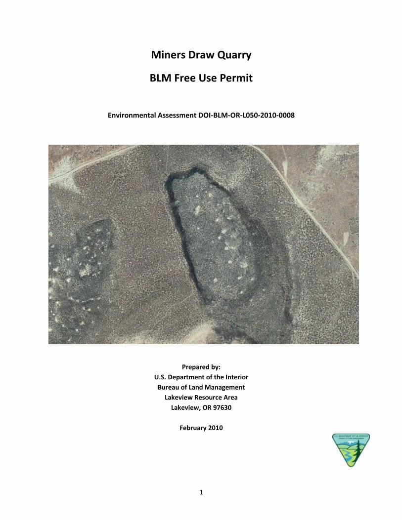
This environmental assessment (EA) has been prepared to analyze the environmental effects of issuing a free use permit to the Bureau of Land Management, Lakeview Resource Area (BLM), for development of a rock quarry for road maintenance needs in the Warner Valley area. Free use permits for mineral materials may be issued to any Federal, state, or other governmental agency and to non-profit entities under 43 Code of Federal Regulation Subpart 3604.
2. Purpose and Need for the Action The purpose of the proposed action is to develop a rock quarry with favorable quality rock that meets BLM road surface specifications. Rock aggregate material is needed for maintenance of BLM roads within the North Warner Valley area, including the main access road to Sunstone Public Collection Area (BLM Roads 6155-00 and 6115-00) and to several dozen sunstone mining operations. The need to develop a new source of rock aggregate in the North Warner Valley has been known for several years. The need for more local sources of rock aggregate has become increasingly more important as fuel and equipment operating costs continue to rise. Increased use of BLM maintained roads in the area, especially the main access roads to the Sunstone Area, has required frequent maintenance in recent years.
The BLM is responsible for maintaining the access roads to the Sunstone Area. Numerous accidents and damage to vehicles has occurred to both tourists and miners traveling to the Sunstone Area in the recent past. These access routes need to be maintained to improve public safety.
To be cost-effective rock maintenance material needs to be available within a reasonable trucking distance of the roads requiring maintenance.
Existing BLM material site sources such as Rabbit Hills, Mugwump Lake, and Mule Springs do not meet material specifications for all-weather road surfacing material due to strength problems discovered during material testing.
The BLM needs to develop a new quarry to allow cost effective and efficient maintenance of BLM transportation plan roads. Increased fuel and equipment maintenance costs would be buffered by reducing the haulage distance of rock materials. The material site would be developed to provide aggregate material for the resurfacing and subsequent maintenance of the Sunstone Road and other adjacent BLM roads.
2.A Background
The basalt rock at the proposed Miners Draw Quarry location meets BLM and ODOT specifications for road surfacing material. A sampling and testing program conducted in September 2009 found that a 30-feet thickness of basalt at this location consistently meets specifications and is close enough to the Sunstone area (approximately 6 miles) that it would be economical to haul. Road maintenance money is available for this project as a result of The American Recovery and Reinvestment Act of 2009, (ARRA; Public Law 111-5).
2.B Location of Project Area
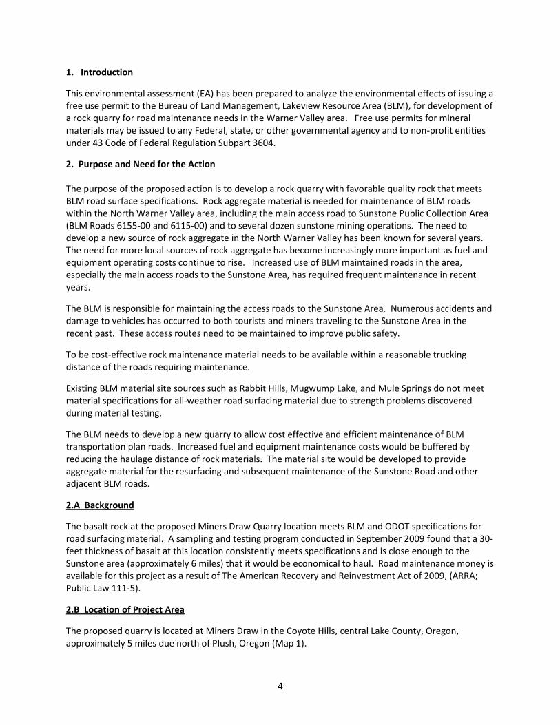
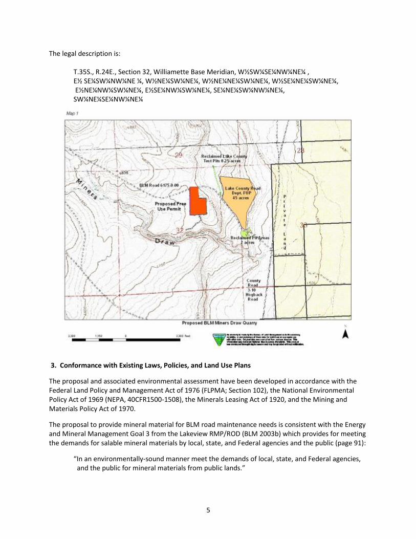
The proposed quarry is located at Miners Draw in the Coyote Hills, central Lake County, Oregon, approximately 5 miles due north of Plush, Oregon (Map 1).
3. Conformance with Existing Laws, Policies, and Land Use Plans
The proposal and associated environmental assessment have been developed in accordance with the Federal Land Policy and Management Act of 1976 (FLPMA; Section 102), the National Environmental Policy Act of 1969 (NEPA, 40CFR1500-1508), the Minerals Leasing Act of 1920, and the Mining and Materials Policy Act of 1970.
The proposal to provide mineral material for BLM road maintenance needs is consistent with the Energy and Mineral Management Goal 3 from the Lakeview RMP/ROD (BLM 2003b) which provides for meeting the demands for salable mineral materials by local, state, and Federal agencies and the public (page 91):
“In an environmentally-sound manner meet the demands of local, state, and Federal agencies, and the public for mineral materials from public lands.”
6
The proposal for developing a quarry for all-weather road surfacing material for use on the Sunstone Road and other BLM road maintenance is consistent with Human Uses and Values Management Direction (page 79): “Provide natural resource amenities on public lands that enhance local communities as places to live, work, or visit (this could include water quality, scenic views, recreation sites, wildlife viewing, hunting, and fishing).” In addition, the project area is designated as open to salable mineral material disposal (Map M-8). The proposed road improvements, weed monitoring, and site rehabilitation actions are also consistent with the road management direction (page 99), Best Management Practices (associated with road maintenance, surface disturbing activities, and mining; see Appendix D, pages A-2 to A-6), noxious weed management (pages 37-38; Appendix D, page A-6; and Appendix G, page A-165) and site rehabilitation direction (Table L2-1, pages A-170 to A-171) of the RMP/ROD (BLM 2003b). The proposed maintenance of the Sunstone Road and other BLM roads is consistent with the RMP direction for continued operation and maintenance actions (RMP 2003, page 100). The proposal is also consistent with the Greater Sage-Grouse Conservation Assessment and Strategy for Oregon (ODFW 2005). This strategy replaced both the interim state guidelines and an existing national strategy. The proposal is consistent because the proposed pit is located outside of occupied sage-grouse habitat. 4. Alternatives Including the Proposed Action
4.A Introduction
The objective of alternative actions is to provide the most cost effective and logistically efficient way to meet future mineral material requirements for road maintenance in the North Warner Lake Valley area. Each alternative focuses on protecting public land resource values consistent with public land management objectives identified in the RMP. Information pertaining to the quarry development was attained from data collected in the fall of 2009. Additional field data collection, review of existing field data and conversations with the Engineering and Resource staff were used to formulate alternatives that provide a reasonable range of alternatives that provide the needed rock material and protect other resource values.
4.B No Action
The no action alternative would eliminate the development of the additional rock material site at Miners Draw. The Sunstone Road maintenance would continue utilizing inferior material from the existing Rabbit Hills material site.
4.C Miners Draw Quarry (Proposed Action)
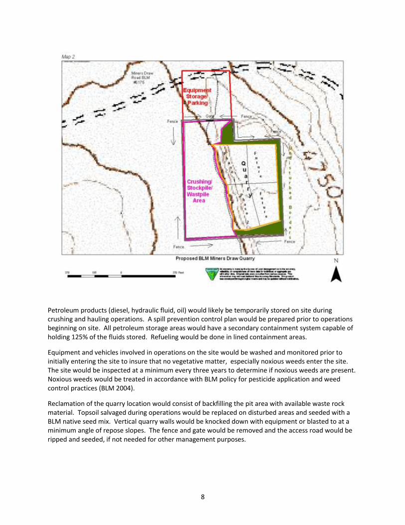
The Miners Draw Quarry would be authorized as a free use permit to the BLM. BLM would have exclusive use of the quarry and would not allow mineral material sales to the general public or other agencies (in contrast to other BLM and Lake County Road Department material sites). Approximately 14 acres would be developed/disturbed for quarry development, road improvement, equipment operations including crushing, and for stockpile and waste pile storage (Map 2). Up to 100,000 cubic yards of
7
crushed rock material would be produced over the 10-year authorization of the free use permit. The existing two-track access road (extending south off of 6175-00; see cover photo) would be upgraded to allow for heavy haul truck travel. The eastern portion of the Miners Draw (6175-00) Road would also require maintenance to fix areas that are rutted and accommodate heavy haul truck travel. Operations could be conducted at the site year-round and would be conducted in several phases:
Future Phases – 50,000 cubic yards Approximately 5 acres of the free use permit would be developed for the quarry. About 5 acres would be used for stockpile storage and equipment operation. About 2.5 acres of the permit area, along the Miners Draw Road would be used for equipment storage, parking, and a turnaround area. About 0.5 acres would be used for upgrading the existing access road. About 1.0 acre would not be disturbed. Site clearing would be avoided during the nesting season (May 15 – July 15). About 11.5 acres of the free use permit area would be fenced. A gate would be installed across the existing access road. The fence around permit area would restrict vehicle access to the quarry, work areas, and stockpiles area to protect public safety and prevent mineral material theft. The fence would be constructed as a three-strand wire fence meeting BLM specifications for wildlife and livestock. During hauling and blasting operations, signs would be installed on the Miners Draw Road to warn the public of heavy truck travel and blasting hazards in the area. During non-operating periods, stockpile cuts would be knocked down to prevent the public from accessing unstable cut slopes. Because the basalt thickness is approximately 30 feet thick at it greatest, the headwall of the quarry is not anticipated to exceed this value. An air-track drill rig would be used to construct holes to depths 20 to 40 feet which would subsequently loaded with blasting agent. The blasting agent would be ANFO (ammonium nitrate and fuel oil) which would fragment the rock to a size fraction amenable to loading operations (typically 15-18 inches in diameter). The fragmented rock would be pushed by a dozer into a pile and loaded into a portable crushing unit to reduce the rock material to a size required for the road surfacing and maintenance. All blasting operations would be supervised by an Oregon State-licensed blasting professional. The crushed rock would be stockpiled in two size fractions, 3-inch minus and 1-inch minus, within the material site until needed for road maintenance. The location of this proposed site is in close proximity to the Sunstone Road to minimize haul distance.
Quarrying and crushing operations on the site would be conducted on an intermittent basis by operators contracted by the BLM. Loading and hauling of material from the site would be done by BLM road maintenance crews or contractors.
During quarrying operations, contractors would commute to the site and not camp within the permit area. Porta-potties or other similar sanitation facilities would be required during quarrying operations.
8
Petroleum products (diesel, hydraulic fluid, oil) would likely be temporarily stored on site during crushing and hauling operations. A spill prevention control plan would be prepared prior to operations beginning on site. All petroleum storage areas would have a secondary containment system capable of holding 125% of the fluids stored. Refueling would be done in lined containment areas.
Equipment and vehicles involved in operations on the site would be washed and monitored prior to initially entering the site to insure that no vegetative matter, especially noxious weeds enter the site. The site would be inspected at a minimum every three years to determine if noxious weeds are present. Noxious weeds would be treated in accordance with BLM policy for pesticide application and weed control practices (BLM 2004).
Reclamation of the quarry location would consist of backfilling the pit area with available waste rock material. Topsoil salvaged during operations would be replaced on disturbed areas and seeded with a BLM native seed mix. Vertical quarry walls would be knocked down with equipment or blasted to at a minimum angle of repose slopes. The fence and gate would be removed and the access road would be ripped and seeded, if not needed for other management purposes.
9
Under the Lakeview RMP/ROD, Appendix N, Attachment 2 – Guidelines for Development of Salable Minerals (BLM 2003b) the following apply:
Operating Procedures:
Oversized boulders shall not be wasted, but shall be broken and utilized concurrently with the excavated material.
The operator shall comply with local and state safety codes for equipment storage and stockpiling rock material is allowed for the duration of the contract or project. Use of the site beyond that time would be authorized under a special use permit.
All topsoil shall be stockpiled or windrowed, as appropriate, for use in reclamation.
Prior to abandonment, all material sites will be graded to conform with the surrounding topography. Oversize material that is not usable, and reject, will be placed in the bottom of the pit, graded, and the pit floor and cut-slopes covered with topsoil. Reseeding, if necessary, will be done as prescribed by the resource area manager. Access roads no longer needed by the BLM will be abandoned and reclaimed as directed by the resource area manager.
10
Quarry Design:
Where in steep terrain in the operating area, quarry developments will require a series of benches to effectively maximize the amount of mineral materials to be removed in a safe manner. In most cases, bench height should not exceed 40 feet, and if the bench will be used by bulldozers to access other parts of the quarry, the width of the bench should be at least 25 feet. If the bench is not used by equipment, then this width can be reduced to approximately 10 feet.
Clearing timber and brush should be planned at least 10 feet beyond the edge of the excavation limit. Most often the brush will be piled and burned at the site, or scattered nearby.
If at all possible, all topsoil and overburden should be stockpiled and saved for eventual quarry site reclamation. These piles may need to be stabilized by seeding in order to minimize erosion during the winter months.
As a standard procedure, the excavation of the quarry floor should be designed with an outslope of approximately 3 percent in order to provide for adequate drainage of the floor. Compliance with this design should be made a requirement of all operators at the site.
4.D Alternatives Considered but Eliminated from Detailed Study
Several existing pits and potential new sites were evaluated during the early stages of the proposal. These sites were eliminated from detailed analysis in this EA because additional field work at these sites yielded data that found the material present was not suitable or of sufficient quantity to meet the area road maintenance needs.
An existing BLM mineral material site at Rabbit Hills was considered, but laboratory testing indicated that the material did not meet specifications for road surfacing material, although it is currently used as a source of material used maintaining the Sunstone Road.
An existing BLM mineral material site at Mugwump Lake was also considered, but upon inspection was discovered not to have the volume of material needed for road surfacing operations.
An existing BLM common use area further up Miners Draw to the northwest was also considered, but because of its location in a narrow canyon, would not have allowed heavy equipment and haul trucks to maneuver easily.
Several basalt outcrops along the eastern edge of the Rabbit Hills were considered for new pit locations, but these did not contain suitable material, would have been visible from the Sunstone Road, and would have involved constructing additional access roads.
Several private sources (Crump Lake) and other government sources (Lake County Hogback Road FUP, Hart Mtn. Wildlife Refuge Hart Lake Pit) were also considered for sources of material, but due to the high cost of hauling material and the volume of material needed, would have not been feasible economically or would have resulted in the depletion of material from these sites and prevented completion of the projects for which they had been intended.
11
5. Affected Environment The affected environment within the Warner Valley area is described as part of the broader landscape of the Lakeview Resource Area within the Lakeview Proposed Resource Management Plan and Final Environmental Impact Statement (BLM 2003a). The majority of that description is incorporated by reference and will not be repeated here. However, a summary of the resource values most likely to be affected by the alternative actions is included in the following section. This section presents the relevant resource components of the existing environment which constitute baseline information for impact analysis comparison purposes.
5.A Climate, Air Quality, and Noise
5.A. 1 Climate and Greenhouse Gases
The climate in the vicinity of Warner Valley is variable, but typical of the Northern Great Basin or high desert system. Mean annual precipitation ranges from 10-16 inches. Precipitation occurs mostly in the form of snow during December through March with spring rains common. The soil temperature regime is frigid. Mean annual air temperatures range from 40 to 43 degrees F. Wind measurements for the site have not been recorded. Data from the Western Regional Climate Center (WRCC) of shows that the nearest RAW station is located at Summit, near Warner Pass on Oregon Highway 140, about 26 miles southwest of the project area has predominate winds from the southwest with an average speed of 6.1 miles per hour. The frost-free time period is from 50 to 80 days. The period of optimum plant growth is from April through June.
Many scientists agree that global climate trends are changing. However, there is not agreement as to whether or not this is primarily a natural cycle, a human-caused event, or some combination of both. Nor is there scientific agreement as to how much climate is likely to change in the future. Future predictions are based primarily on outputs from global climate models. The outputs (predictions) from these models vary widely and depend largely upon the data and assumptions used as input. In addition, many other factors or variables are known to have an effect on climate, but only a few have been modeled or studied (Taylor 2009). Some studies suggest increases in greenhouse gas levels affect global climate. Forster et al. 2007 (pp. 129-234) reviewed scientific information on greenhouse gas emissions and climate change and concluded that human-caused increases in greenhouse gas emissions are likely to have exerted a substantial warming effect on global climate. However, another reviewer noted that other studies have indicated that average global temperatures have actually been much warmer in the past 1,000 years (IPCC 1990, as cited in Taylor 2009) and this warmer period was due to natural forces.
The BLM NEPA Handbook states that a topic must have a cause and effect relationship with the proposed action or alternatives to be considered an issue that needs to be analyzed (see page 40; BLM 2008). Further, the U.S. Geological Survey (May 14, 2008 memorandum to the U.S. Fish and Wildlife Service) has reviewed the latest science on greenhouse gas emissions and concluded that it is currently beyond the scope of existing science to identify a specific source of greenhouse gas emissions or sequestration (storage) and designate it as the cause of specific climate impacts at a specific location. That memorandum is incorporated here by reference. The proposed action and alternatives do not have a clear cause and effect relationship on climate because the available science cannot identify a specific source of greenhouse gas emissions or storage and tie it to a specific amount or type of climate change.
12
However, the BLM can estimate greenhouse gas emissions and carbon sequestration resulting from the various alternatives. The most common greenhouse gases include (in descending order) water vapor, carbon dioxide, methane, and nitrous oxide. Of the four, water vapor represents over 90% of all greenhouse gases present in the atmosphere (Taylor 2009). Methane and nitrous oxide emissions represent a very small percentage of all greenhouse gases in the U.S. and have actually declined between 1990 and 2007 (EPA 2009).
5.A.2 Air Quality and Noise
The project area is located within the U.S. Environmental Protection Agency, Region 10, Eastern Oregon Air Quality Control Region. The air quality in the area is generally good and typical of large rural areas within the Great Basin and the Coyote Hills area. The principal source of air contaminants in the project area is from wind-blown dust, from agricultural operations on private lands to the east, from dry rangeland in the region, and from occasional traffic along dirt roads. During the summer months dust storms and rangeland wildfires may negatively affect air quality.
Current noise sources at the project area are primarily vehicular travel along the Miners Draw Road with occasional overhead flights by military jets using a low altitude military operation area (MOA). Noise from agricultural operations and County Road traffic, approximately 2,800 feet to the east may occasionally be heard at the site.
5.B Geology and Minerals
The site is located on a prehistoric lakeshore bench to the west of the Hogback Road (County Road 3-10). The lakeshore sediments at this site consist of unconsolidated to semi-consolidated silt, sand, and gravel. Discontinuous layers of mudflow material, fluvial or windblown silt may be buried within the proposed project area. The quarry would be excavated into a basalt knob that lies above the upper high water mark of Pleistocene Lake Warner.
The Coyote Hills lies within the Basin and Range Physiographic Province. Basin and Range faulting is a result of crustal extension which was initiated around 17 million years ago, with generally north to south normal range front faulting. The Coyote Hills is a shield volcanic center formed from alternating volcanic-pyroclastic flows with dacitic to andesitic composition with numerous intrusions trending in a general north to south direction. More recently, flood basalts, contemporaneous with flood basalts of Columbia Plateau, were formed. Later volcanism included formation of ash flow tuffs and intermittent flood basalt formation.
The proposed quarry material is from one of the later basalt flows and has been labeled the Upper Basalt. The basalt rim of the proposed quarry is approximately 30 feet thick with a 10 foot thick base of gray and massive olivine basalt, a 10 foot thickness of intercalated volcaniclastic rock (a sand rich layer with basalt and other volcanic rock fragments), and a 10 foot upper layer of massive basalt. All layers meet the testing specifications for road surfacing material.
The mining history of the Coyote Hills begins around 1906 with small level gold mining activity in the Coyote Hills District (aka Camp Loftus, Windy Hollow, Lost Cabin). In 1934, cinnabar mining began with most production occurring between 1941-1943. In 1978, an exploration drilling program was conducted in the upper Miners Draw area. Since that time there has been little activity and no active mining claims are currently held in the area. The ore deposits so far found are characterized as being spotty, low grade veins, although the potential exists for larger vein deposits or disseminated type
13
deposits. Further sampling and/or exploration is possible in the future given the recent increase in metal prices, especially gold.
5.C Soils
Upland rangeland soils found within the project area were surveyed and described in the Soil Survey of Lake County, Southern Part (NRCS and BLM Undated). At the proposed quarry location in Miners Draw, the mapped soil unit is identified as the Old Camp very cobbly loam, 2 to 15 percent slopes. These soils are shallow (8-10 inch depth) and well drained with a moderate erosion hazard. No evidence of large slope stability failures were seen along the basalt rim. The majority of the project area is on areas where the surface slope is level. These areas would be used for equipment operation and stockpile storage. The basalt rim where the actual quarrying would occur is on a slope that exceeds 60 percent in some areas. Under the Lakeview RMP/ROD (BLM 2003b), prior to the disturbance of slopes of over 60 percent, an engineering reclamation plan must be approved by the authorized officer with an exception for operations that can mitigate slope stability concerns. These areas that exceed 60 percent are extremely small in extent and bounded by a level basalt top and base. These areas would eventually be mined through to solid basalt base. No slope stability issues are anticipated other than potential for rock fall from the quarry face during quarrying operations. 5.D Watershed Resources The area surrounding the proposed Miners Draw Quarry site drains into Miners Draw, a distance of over 1,000 feet. The Miners Draw drainage is intermittent at this location and generally flows only during spring runoff or in response to the occasional large precipitation event. Miners Draw eventually drains into the Warner Valley to the east below Hart Lake in the vicinity of Anderson Lake. Though there is no water quality data available from the area, the Miners Draw drainage is not currently listed as a 303(d) stream by the Oregon DEQ. No perennial streams, wetlands, or riparian areas occur on the site. No springs or wells are located within the immediate project area. Developed springs exist in Miners Draw about 3 miles to the northwest of the project area. Five ground water wells are located on private lands in Section 33 on the valley floor, the nearest is about 4,200 feet from the project area. These are used for either irrigation (pivot lines) or for livestock use. These wells vary from 100’ to 460’ depths. It is unknown at what depth the water table is within the project area. 5.E Vegetation The dominant native vegetation at the proposed pit is Thurber needlegrass, Wyoming big sage, Indian ricegrass, bottlebrush squirreltail, and bluebunch wheatgrass. Other vegetation on site includes cheatgrass and annual mustards. 5.F Noxious Weeds Cheatgrass (Bromus tectorum) was the only weed species identified in the botanical survey completed during the summer of 2009 at the proposed quarry site. Annual mustards were also present in modest quantities. However, hoary Cress (Cardaria draba) is located in the area adjacent to the proposed quarry.
14
5.G Special Status Plants A botanical survey was completed during the summer of 2009. No Special Status plants were found within the footprint of the proposed quarry or within ¼ mile buffer surrounding the proposed quarry. 5.H Wildlife, Fish, and Special Status Animals
Field inventory revealed the project site provides minimal or low-quality habitat for wildlife. Numerous wildlife species, common to the sagebrush-steppe eco-type, occur within the general vicinity and include: mule deer, pronghorn antelope, coyotes, bobcats, ground squirrels, jackrabbits, cottontails, badgers, marmots, meadowlarks, sparrows, mice, voles, raptors, and bats.
No known crucial habitat has been identified within the proposed development area for any wildlife species. Field inventory did not find any Threatened or Endangered species or habitat at the proposed quarry site. However, some BLM and State of Oregon sensitive species may, on occasion, forage in the area. Townsend’s big-eared bats are known to roost and hibernate in the hills to the west of the proposed site and may at times forage in the area. Pallid bats are known to use habitat similar to that found at the proposed pit and could be found in the area at times. Bald eagles winter in the surrounding area. Golden eagles are year round residents of the general area. No sagegrouse or pygmy rabbit habitat exists on the site.
There are no perennial stream channels, fish habitat, or fish populations within the proposed project area. An intermittent drainage exists to the north of the project area and extends to the northwest up Miners Draw. Refer to the watershed discussion above for more information.
5.I Livestock Grazing
The proposed pit is located in the East Coyote Hills Pasture of the Coyote-Colvin Allotment (#0517) (refer to Map G-3 of the Lakeview RMP/ROD (BLM 2003b)). The allotment consists of 7 pastures and is managed under a rest rotation grazing management system, as defined in the Lakeview Resource RMP/ROD (Table 5, page 48; and Appendix E5, pageA-147). The permitted season of use is from 2/5-12/14 with a total active Animal Unit Months (AUMs) of 5,091. The Coyote-Colvin Allotment contains approximately 123,038 acres BLM-administered land. The East Coyote Hills Pasture consists of approximately 3,8131 acres of BLM-administered land.
5.J Recreation and Visual Resources
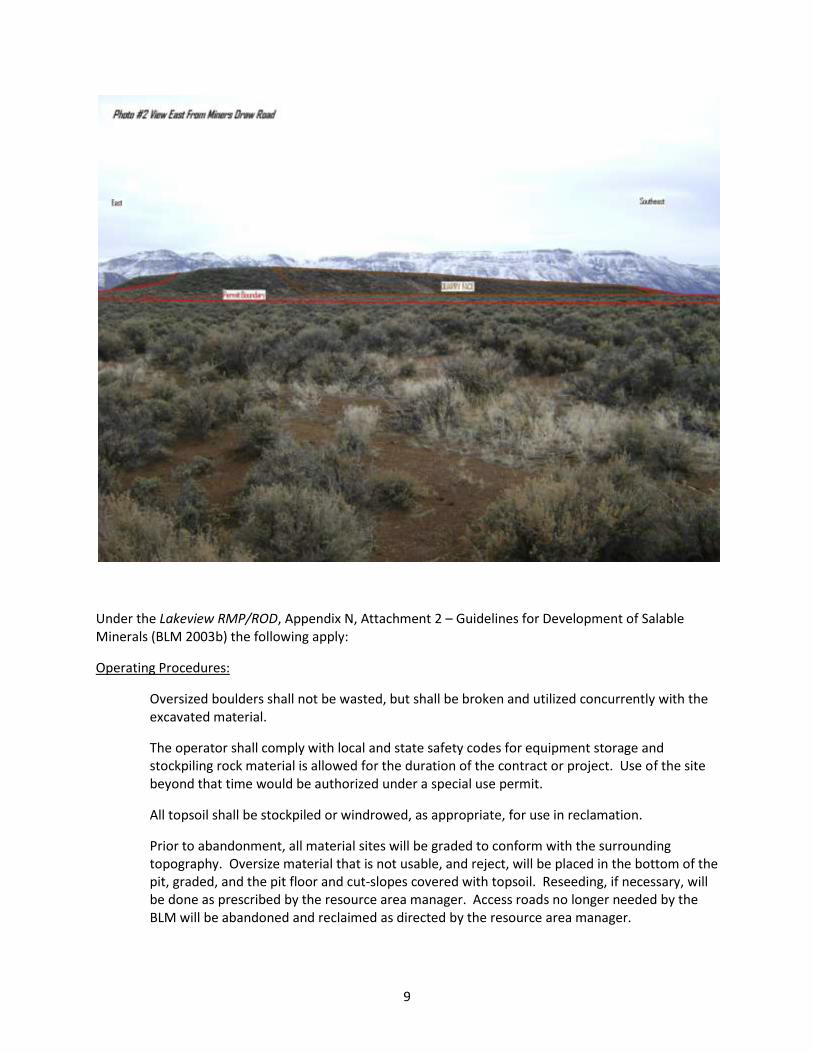
The immediate area around the project is generally used by hunters, campers, general sightseeing and off-highway vehicle travel (OHV). Camping and OHV use has been noted at the adjacent mined-out pit (reclaimed by the Lake County Road Department in 2005) and in other areas adjacent to the Miner Draw Road. The surrounding area is currently open to OHV use (see Map R-7; BLM 2003b).
County Road 3-10 is a main access road for all types of recreation in the Warner Valley including access to the Warner Wetlands to the east and the Public Sunstone Collection Area to the north. Recreational use of the Public Sunstone Collection Area has increased in recent years.
The proposed pit area is classified as visual resource management (VRM) Class IV. The objective of Class IV is to provide for or allow management activities that may require major modification of the landscape. In Class IV areas, management activities may dominate the view and become the focus of
15
viewer attention. However, efforts should be made to minimize the impacts of a given project by carefully locating the activity, minimizing disturbances, and designing the project to conform to the characteristic of the landscape.
5.K Wilderness, Wild and Scenic Rivers, Areas with Wilderness Character, Areas of Critical Environmental Concern, and Research Natural Areas No designated wilderness or Wilderness Study Areas (WSAs), Wild and Scenic Rivers (WSRs), Areas of Critical Environmental Concern (ACECs), or Research Natural Areas (RNAs) are within or near the project area. In 2005, the Oregon Natural Desert Association (ONDA) submitted a Wilderness Inventory Recommendation report to the Lakeview District which identified a large block of surrounding BLM-administered lands to the north and west as a potential wilderness study area which they have called the Coyote Hills Proposed Wilderness Study Area. The BLM completed its own evaluation of the wilderness character within this proposal in early 2010 and has determined that wilderness character is not present (BLM 1010) and, therefore, will not be discussed further in this analysis. 5.L Cultural and Paleontological Resources
A cultural survey has been completed. No cultural or historic sites were found at the proposed quarry site.
The proposed material site is located along the uppermost high water mark of Pleistocene Lake Warner. Areas along the old Pleistocene Warner Basin shoreline contain limited accumulations of Pleistocene mollusks or vertebrate fossils, but no fossil accumulations are known or have been observed in the proposed project area. The actual quarry operations would occur within a basalt flow, where fossils of any type are unlikely to be found.
5.M Lands and Realty
There are no existing land use authorizations (ROWs, etc.) in the project area or the immediate surrounding area. Both the surface and subsurface estates of the project area are held by the Federal government. The Miners Draw access road to the project area (BLM #6175) does not cross private lands from its intersection with County Road 3-10, so there would be no easements needed for road upgrade or maintenance. For this reason, lands and realty will not be discussed further in this document.
5.N Socio-Economic
The proposed quarry is located within Lake County, Oregon. The population of Lake County is approximately 7,239 (2008 Estimate). The small community of Plush, population 82 (2000 Census) is located approximately 5 miles to the south. Plush has limited services, including some retail with a public elementary school, but no lodging services. The local economy is based largely on livestock, agriculture, tourism, and commercial and recreational mining of sunstones. The nearest medical services are provided by the Lake District Hospital located at the county seat of Lake County, Lakeview with a population of 2,655 (2006 Estimate) a distance of approximately 50 miles to the southwest. Lakeview also has the nearest lodging available.
Recreation use of BLM-managed lands generates local economic activity in several ways. Visitors to the area purchase food, fuel, lodging, and other goods and services from local businesses (BLM 2003a).
16
Oregon Sunstones have been featured on numerous television programs and in newspaper articles throughout the region. Because of these stories, a large increase in the number of visitors to the Sunstone Area has occurred over the last five years, which has positively impacted the local economy.
In FY2009, an estimated 3,200 vehicle trips were made to the Sunstone Public Collection Area. This number is based on traffic counters in the area. This number is used to calculate the number of visitors to the site in FY2009 at 8,000.
Commercial operations at the Sunstone Area currently include 10 producing mines operating under plans of operations and 47 notice level (exploration or small-scale production) mining areas.
All of this has led to increased motor vehicle use and associated safety concerns on the access roads (6155-00 and 6115-00) leading to the Sunstone Area. The increased vehicle use has created potholes and washboard sections on the on-lane access roads. Road conditions, in turn, have impacted the number and types of vehicles that can currently visit the site, especially larger vehicles such as motor homes. This has prompted the BLM to create a Safety Corridor on the main access roads to limit speed to 35 miles per hour.
6. Environmental Consequences This chapter is organized by alternative and describes the differences between the proposed action and the no action alternatives. The following elements of the human environment are either not present in the project area or were determined not to be negatively impacted by either the proposed action or the no action alternative: drinking water resources, perennial streams, wetlands or riparian areas, fish or aquatic habitat, lands and realty, designated wilderness or WSAs, areas with wilderness characteristics, wild and scenic rivers, ACECs, RNAs, wild horse herds or herd management areas, cultural, historic, or paleontological resources, native American traditional use or religious areas, prime or unique farmlands, special status species including threatened or endangered plants and animals, or hazardous waste sites. Neither alternative would have an adverse or disproportionate impact on minority populations.
6.A Alternative 1 (No Action Alternative)
6.A.1 Climate, Air Quality, and Noise
Greenhouse Gas Emissions
The No Action Alternative would have no effect on carbon storage/sequestration processes and no measurable increases in U.S. or global nitrous oxide and methane emissions.
Because of the amount of traffic the access roads receive each year and the unsuitability of material from other existing rock sources in the general vicinity for use as surface rock, it is probable that the 2 access roads would require annual maintenance, at a minimum. This could include running a grader over the 2 roads and spot-rocking problem areas (ie. potholes). For this reason, the primary effects on green house gases under this alternative would be associated with carbon dioxide emissions from annual road maintenance activities. The emissions can be estimated assuming the following:
17
a) Road Grader operating about 22 days/ year x 10 hours per day x 6 gallons diesel fuel per hour x 10 years = 13,200 gallons diesel b) Carbon dioxide emissions from burning a gallon of diesel average 22.2 pounds per gallons (EPA undated). Based on these assumptions, the total heavy equipment carbon dioxide emissions associated with road maintenance that would occur under the no action alternative would be about 293,040 pounds or 132.9 metric tons over a 10-year period. This equates to about 13.3 metric tons annually. Between 1990 and 2007, the estimated annual total emissions of carbon dioxide from all transportation sources in the U.S. ranged from 1484.5 to 1887.4 teragrams (1012) or 1,484,500,000 to 1,887,400,000 metric tons. The annual estimated total carbon dioxide emissions from all human sources in the U.S. ranged from 4,871,000,000 to 5,919,500,000 metric tons during this same time period (USEPA 2009). Thus, the annual contribution of carbon dioxide from heavy equipment emissions associated annual road maintenance in the Sunstone area represents no more than 0.000000896% of all annual U.S. transportation related emissions and no more than 0.000000227% of all U.S. human-related emissions. The EPA only requires mandatory reporting from several industrial and agricultural sectors for total carbon dioxide equivalent quantities greater than 25,000 metric tons per year (see 40 CFR 98.2). The annual carbon emissions under this alternative are very small compared to this reporting threshold and, therefore, are not significant. Air Quality and Noise Under the No Action alternative, there would be no change to existing noise levels or other air quality parameters near the quarry area. Fugitive dust levels that currently occur from vehicle use on BLM roads leading to the Sunstone Area would remain unchanged.
6.A.2 Geology and Minerals
Under the No Action Alternative, there would be no changes to the geology or mineral resources at the proposed quarry site or surrounding environment.
6.A.3 Soils and Watershed Resources
Soil and watershed resources in the Miners Draw area would remain unchanged under the No Action alternative unless some other surface disturbance (ie. wildfire) occurred at some point in the future.
6.A.4 Vegetation
Under the No Action alternative, vegetation at the proposed quarry site would not be disturbed by quarry development and would generally remain in its current quantity and condition unless some other disturbance (ie. wildfire) occurred at some point in the future.
18
6.A.5 Noxious Weeds Under the No Action alternative, the site would remain in its current condition unless some other disturbance (ie. wildfire) occurred at some point in the future. Due to its location immediately adjacent to two roads and a drainage, the site retains a moderate potential for weed invasion from future vehicle travel and water transport mechanisms. The adjacent hoary cress (Cardaria draba) site would be treated and monitored in accordance with the existing Integrated Noxious Weed Treatment Program
(BLM 2004). The impacts of this on-going weed treatment program are described in detail in the previous weed treatment EA and will not be repeated here.
6.A.5 Wildlife
Under the No Action alternative, the existing, marginal wildlife habitat would remain undisturbed unless some other disturbance (ie. wildfire) occurred at some point in the future.
6.A.6 Livestock Grazing
The No Action alternative would have no effect on livestock grazing in the East Coyote Hills Pasture of the Coyote-Colvin Allotment. Current livestock grazing activity would continue at the proposed quarry site under this alternative.
6.A.7 Recreation and Visual Resources
Under this alternative, the existing recreation opportunities and visual quality within the Miners Draw area would be unchanged. However, the upgraded road access to other recreation areas in Warner Valley, including the Sunstone Area, would not occur. 6.A.8 Socio-economic Under the No Action alternative, the existing socio-economic conditions within the immediate area and surrounding Lake County would not change substantially. The intermittent or short-term economic benefits to surrounding communities associated with the proposed quarry would not occur. Upgrading of BLM Roads, primarily 6155-00 and 6115-00, would not occur, possibly reducing future tourism or public use in the area. Safety concerns associated with the amount of traffic on these one lane roads would not be addressed. Traffic flow would not be improved.
6.B Alternative 2 (Proposed Action-Development of Miners Draw Quarry)
6.B.1 Climate, Air Quality, and Noise
Greenhouse Gas Emissions Carbon dioxide, nitrous oxide, and methane would be generated during quarry operations primarily by equipment use (generators, track drill rigs, trackhoe excavators, graders, etc.) and vehicle travel (haul trucks, service trucks, etc.). Generation of carbon dioxide and nitrous oxide would also occur during
19
blasting operations utilizing ANFO explosives. Operations would also generate carbon monoxide, which is not considered a direct greenhouse gas, but can affect levels of other greenhouse gasses, such as methane, by reacting with OH (hydroxyls) in the atmosphere. This alternative would have no effect on carbon storage/sequestration processes and cause no measurable increases in U.S. or global nitrous oxide and methane emissions. For this reason, the remainder of this discussion focuses on estimating carbon dioxide emissions.
During the estimated 10-year operation of the quarry, approximately 100,000 cubic yards of crushed rock would be produced. Much of this material would be utilized in upgrading the Sunstone access roads an average distance of 12 miles from the quarry location. This would require an average 24 mile roundtrip to haul material from the quarry. Haul trucks that would be used could be single 10 cubic yard dump or 20 yard tandem dump truck, an average of 15 cubic yards. An estimate of 10 miles per gallon is assumed for the haul trucks. Operations at the quarry itself are estimated at 1 month per year for the 10 year life of the quarry. Using an estimated 22 days per month with 10 hour workdays = 220 hours per year. Utilizing the above assumptions fuel consumption for various types of equipment can be estimated as follows: a) Generator - 500 kW/hour generator x ¼ generator load x 11 gallons/hour x 220 hours/year x 10 years = 6,050 gallons of gasoline b) Trackhoe – 6 gallons per hour x 220 hours/year x 10 years = 13,200 gallons of diesel fuel c) Travel from Lakeview – 80 miles roundtrip/day x 22 days/year x 10 years x 15 mpg = 1173 gallons of gasoline d) Blasting – estimate 500 lbs. ANFO/year x 10 years = 5000 lbs. ANFO e) Haul Trucks - 100,000 cubic yards/15 cubic yards per trip x 24 miles/trip/10 miles/gallon = 16,000 gallons of diesel fuel f) Road Grader operating about 22 days/ year x 10 hours per day x 6 gallons diesel fuel per hour x 10 years = 13,200 gallons of diesel fuel The total estimate of the gasoline and diesel fuel consumption over the 10-year life of the project is about 7,223 and 42,400 gallons respectively. Carbon dioxide emissions from burning a gallon of diesel fuel average 22.2 pounds per gallons and 19.4 pounds per gallon for gasoline (USEPA undated). Based on the above assumptions, the total carbon dioxide emissions associated with quarry operation and road maintenance would be about 490.4 metric tons over a 10-year period. This equates to about 49 metric tons annually. Blasting of 5000 lbs. of ANFO explosives is estimated to release about 1.67 lbs. of carbon dioxide per 1 lb. of ANFO (Climate Mitigation Services 2007). This translates into an estimated 3.8 metric tons total or about 0.38 metric tons per year.
20
Thus, the annual estimate of carbon dioxide emissions from all quarry operations and road maintenance activities is about 490.8 metric tons. This represents no more than 0.00000331% of all annual U.S. transportation related emissions and no more than 0.0000010% of all U.S. human-related emissions.
The EPA only requires mandatory reporting from several industrial and agricultural sectors for total carbon dioxide equivalent quantities greater than 25,000 metric tons per year (see 40 CFR 98.2). The annual carbon emissions under this alternative are very small compared to this reporting threshold and, therefore, are not significant. Air Quality and Noise Air quality impacts from mining would primarily be from particulate matter or fugitive dust generated by quarrying and crushing operations and hauling rock off the site. Because of both the seasonal nature of these operations and the small scale of quarrying and hauling activities, air quality impacts would be
both short-term and minimal. The BLM would be required to obtain a Basic Air Quality Permit from the Oregon DEQ for quarry operations that process between 5,000 and 25,000 tons/year. Other sources of fugitive dust such as from topsoil stockpiles or waste piles would be reduced through the use of interim seeding of these areas. Road surfaces would be modified from a natural soil material consisting of sand-, silt-, and clay-size particles to a nominal 1-inch rock aggregate. The existing road surface material is more effectively transported by wind and vehicle activities than the coarse-grained rock aggregate that would be present upon project completion, especially on the end portion of the Sunstone Road that has not been graveled and many of the non-graveled roads in the North Warner Lake Valley. Therefore, some measure of air quality improvement would be realized. Noise sources from the proposed operations would include heavy equipment, crusher operation, blasting, and haul truck travel. The nearest residences to the proposed quarry location are located to the south at a distance of 6,390 feet and to the southeast along County Road 3-10, a distance of about 8,700 feet. The nearest private land is located 2,800 feet due east of the proposed quarry location. Current noise levels in the vicinity of these receptors are unknown, but noise impacts from mining operations are expected to be minimal, although occasional haul truck travel could be noticeable at these locations. The proposed quarry location is not within one-half mile of a “noise sensitive area” as defined by the Oregon Department of Environmental Quality.
6.B.2 Geology and Minerals Under the proposed action, geologic impacts would be minimal. No evidence of landslide or slope stability issues were seen during field visits at the site. It is possible during blasting operations, that small slabs of basalt could be loosened along vertical cracks in the basalt rim in the immediate vicinity of the quarry location. This could result in small rockfall areas outside of the quarry area. No impact to other mineral resources is anticipated since the project area has not been a focus of any known locatable or leaseable mineral interest. A check of the LR2000 mining claim records found that no mining claims are or have been located at this location. Improvements to the Sunstone Road as a result of the proposed action could increase vehicle travel and access to the Sunstone Area. This could increase interest in sunstone development in the surrounding area.
21
6.B.3 Soils and Watershed Resources
Soils on the proposed quarry site would be permanently altered over the long-term as the site is developed. Existing topsoil is limited on the site, but would be scraped from the 5-acre quarry area, stock-piled, and seeded for future use in site reclamation.
Erosion would occur from soil disturbance during quarrying, processing, and hauling operations. An increase in off-site sedimentation could occur from erosion in the project area due to project activities. Sediment could potentially be available from the roads, waste rock piles, and quarry operation areas. However, the application of project design features (BMPs and mitigation measures described in Section 7 of this EA) would decrease these impacts.
Mining operations could contribute to minor, but adverse watershed effects by increasing overland flow, erosion rates, and sediment transport to the intermittent Miners Draw drainage. Adverse effects to water quality would be minimized or avoided by designing mine operations to meet water quality standards, incorporating BMPs, and adhering to State and Federal laws and regulations (see Section 7 of this EA).
The proposed quarry excavation would occur in a basalt, or basalt-rich sedimentary unit which are not known to be sulfide bearing. The inert basalt would, therefore not pose an acid rock drainage effect (metal dissolution) since sulfide deposits are not present.
Water quality would not be negatively impacted by area road surfacing/maintenance activities as there would be less sediment carried in the runoff water compared to what currently occurs from existing road surfaces. No impacts to groundwater are expected to occur because of the anticipated depth to groundwater. Even with blasting in areas where the water table is much nearer the surface, the observed impacts are temporary and limited, including causing temporary turbidity, but no physical damage to the aquifer or to wells. This is based partly on studies that show fracturing in the rock around a blast hole is generally limited to 20 to 40 times the blast hole diameters; for a standard 3½ inch blast hole, the zone of fracturing would be limited to a 6-12 foot radius from the blast hole (Oregon Department of Transportation, Rock Blasting and the Community). The water table at the proposed quarry location is expected to be at a much greater depth than the depth of fracturing. Petroleum products could be stored on site for short periods of time during quarrying operations. Storage areas and refueling areas would have spill containment preventing spills or leaks from entering the soil. Fuel or lubricant spills from equipment failure could occur. If such equipment problems occur the equipment would be brought to a lined containment area to prevent contamination of groundwater or surface runoff. The contaminated area would be excavated and remediated in accordance with state regulations.
6.B.4 Vegetation
About 13 acres of vegetation would be removed during the construction and operation of the quarry for a period of at least 10 years. At the end of mining activity, the site would be contoured and reseeded with appropriate native species.
22
6.B.5 Noxious Weeds
Due to its location immediately adjacent to two roads and a drainage, the additional surface disturbance associated with quarry development, and the increase in vehicle/equipment use at the quarry site, this alternative has the highest risk for future weed invasion. Hoary cress (Cardaria draba) is located in the area adjacent to the proposed quarry, but would be treated before any surface disturbing activities
occur on the site. Treatment and monitoring of this site and any other sites that could develop in the future would occur as outlined in the Integrated Weed Management Program (BLM 2004). The impacts of this on-going weed treatment program are described in detail in that EA and will not be repeated here.
6.B.6 Wildlife
The soils within the quarry area are fairly rocky and are not conducive for pygmy rabbit burrow construction. The field survey found no pygmy rabbit burrows, pygmy rabbit sign, or rabbits at this location. Therefore, the quarry would have no negative effects on pygmy rabbit habitat or populations. A few migratory birds would likely be displaced by the construction of the quarry. Clearing of native vegetation would be avoided during the nesting season from May 15 – July 15. The 13 acres of habitat lost during the 10-year operation would not cause a significant or population level effect on migratory bird species. The site has poor habitat quality characteristics for sage-grouse. Although sage-grouse habitat does exist elsewhere in the general Miners Draw area, no sage-grouse are known to use the area associated with the proposed quarry. Therefore, the quarry would have no negative effects on sage-grouse habitat or populations. The closest known eagle nest (golden eagle) is located approximately 6 ¼ miles southwest of the proposed quarry. This site is well outside of the U.S. breeding seasonal home range radius estimate of 4 miles (USFWS 2009). Golden or bald eagles may occasionally forage for prey in the area of the proposed quarry. However, the area of disturbance is minor and disruption to foraging activities of eagles would be of little or no significance. Townsend’s big-eared bats roost and hibernate in the hills to the west of the project area and pallid bats may also be found in the area. These bats may forage over in the vicinity of the proposed quarry. Direct disturbance to these two species would be minimal as they forage after dark, past the normal time of quarry operation.
6.B.7 Livestock Grazing
Under the Proposed Action, about 11.5 acres would be fenced and temporarily removed from the allotment. Due to the small area involved, there would be no need to adjust or reduce forage allocation (AUMs) on the existing grazing permit. This small exclosure would have no substantial effect on the total livestock forage available within the allotment. Livestock trailing would not be restricted (along the main access road up Miners Draw) nor would other changes be needed in grazing management.
23
During site reclamation, cattle may graze on the unfenced (about 1.5 acres) newly-seeded area, resulting in slower reclamation success. The seeded area within the fence (11.5 acres) would reclaim faster. Following seeding establishment, the fence would be removed and grazing use allowed back on the site.
6.B.8 Recreation and Visual Resources
The site would be fenced to protect processed material stockpiles from theft and to protect the recreating public from safety hazards associated with quarry operations. The existing two-track road would be gated, blocking public access to this road. However, this route dead-ends approximately ½ mile to the south of the quarry site, does not currently receive much use, and would not result in the loss of much public motorized access to the surrounding area. This alternative would allow BLM Roads in Warner Valley to be maintained or improved in the future with gravel from this rock quarry. This would result in improved recreational access to the surrounding area, most specifically to the Public Sunstone Collection Area. For these reasons, the quarry would not have significant negative effects on recreation opportunities within the Miners Draw area and would result in improved recreational and public access to other recreation sites in the Warner Valley. Because of the proposed layout of the quarry, all activities on the site would be screened from view from the east by a basalt ridge that would not be completely removed. Neither the quarry, stockpiles, or equipment would be visible from County Road 3-10. On occasion, fugitive dust from quarry operations could be visible. Operations would be visible from the Miners Draw Road and from higher elevations of the Coyote Hills to the west, but fewer people typically travel from this direction. The proposed quarry is consistent with the VRM Class IV management objectives. For this reason, along with the screening provided in the project design, there are no significant negative impacts to scenic or visual quality from this project.
6.B.9 Socio-Economic
Development of the Miners Draw Quarry would support secondary employment in other industries within the local area, particularly services, through the spending of workers’ wages in the local economy, and also through the purchase of goods and services as a result of quarrying operations. This impact would be both intermittent and short term. Employment of local people during quarry operations is possible if the quarrying contract is issued to a local contractor, but would again be intermittent and short term.
Upgrading BLM maintained roads in the North Warner Lake Valley, especially the Sunstone Road, could increase tourism and recreational activity in the area, primarily at the Sunstone Area. This impact, although limited primarily to the summer season, would be long term and would have a slightly positive impact on businesses that support tourism both in Plush and Lakeview and other communities in Lake County. Additionally, sunstone commercial mining could possibly expand at the Sunstone Area with improved access road conditions and could result in longer seasons of operations.
Blasting operations at the proposed quarry are expected to be small-scale and intermittent. Because of the distances to private land and residences, no impact is expected from blasting operations to private property. Within the immediate area of the quarry, the possibility exists that some flyrock could be generated during blasting operations. Utilizing Best Management Practices for Blasting should reduce
24
both the amount of flyrock and possible distances of impact for flyrock. A maximum potential flyrock range of 1500 feet was estimated utilizing charts for calculating flyrock distance utilizing a standard 3.5 inch blast hole and an estimated average boulder size of 18 inches. (OSM/Appalachian Region Technology Transfer Blasting Workshop 2008). Other possible impacts from blasting, ground vibration and airblast, are expected to be restricted to the immediate area around the proposed quarry area. During blasting operations, the site would be secured by the contractor and/or the BLM to insure that the public is kept at a safe distance from the site.
During hauling operations, truck travel would increase on both the Lake County Hogback Road (3-10) and BLM roads in the area, especially the Sunstone Road. Road maintenance and surfacing operations on BLM roads could result in slight delays to public travel, but upon completion would facilitate safer vehicle travel on these same roads.
7. Best Management Practices
Best Management Practices (BMPs) are listed in Appendix D of the Lakeview RMP/ROD (BLM 2003b). BMPs are land and resource management techniques designed to maximize beneficial results and minimize negative impacts. Specific BMP’s are selected and implemented as necessary, based on site-specific conditions, to meet water, soil and other resource management objectives. BMP’s for this quarry proposal are designed to assist in achieving the objectives for limiting potential impacts to water quality, reducing the likelihood of noxious weed spread, and aiding in site reclamation.
7.A Surface-Disturbing Activities (Page A-4)
1) Special design and reclamation measures would be required to protect scenic and natural landscape features. This may include mulching and fertilizing disturbed areas and maintaining low-profile stockpiles and berms associated with the material pits to minimize visual contrasts.
2) Above ground facilities requiring painting should be designed to blend in with the surrounding environment.
3) Disturbed areas should be contoured to blend with the natural topography. Blending is defined as reducing form, line, and color contrast associated with the surface disturbance. Disturbance in visually sensitive areas should be contoured to match the original topography, where matching is defined as reproducing the original topography and eliminating form, line, and color caused by the disturbance as much as possible.
4) Reclamation should be implemented concurrent with construction and site operations to the fullest extent possible. Final reclamation actions shall be initiated within 6 months of the termination of operations unless otherwise approved in writing by the authorized officer.
5) Fill material should be pushed into cut areas and up over back slopes. Depressions should not be left that would trap water or form ponds.
7.B Mining (Page A-6)
1) Reclaim all disturbed surface areas promptly, performing concurrent reclamation as necessary, and minimize the total disturbance of all surface disturbance.
2) All surface soil should be stripped prior to conducting operations, stockpiled, and reapplied during reclamation, regardless of soil quality. Minimize the length of time soil remains in stockpiles and the depth or thickness of stockpiles. When slopes on topsoil stockpiles exceed 5 percent, a berm or trench should be constructed below the stockpile to prevent sediment transport offsite.
3) Strip and separate soil surface horizons where feasible and reapply in proper sequence during reclamation.
25
4) Locate soil stockpiles and waste rock disposal areas away from surface water to minimize offsite drainage effects.
5) Establish vegetation cover on soil stockpiles that are to be in place longer than 1 year. 6) Consider temporary measures such as silt fences, straw bales, or mulching to trap sediment in
sensitive areas until reclaimed areas are stabilized with vegetation. 7) Reshape to approximate original contour all areas to be permanently reclaimed, providing for
proper surface drainage. 8) Leave reclaimed surfaces in a roughened condition following soil application. 9) Complete reclamation and seeding during the fall if possible.
7.C Noxious Weed Management (Page A-6)
1) All contractors and land-use operators moving surface-disturbing equipment in or out of weed-infested areas should clean their equipment before and after use on public land.
2) Control weeds annually in areas frequently disturbed such as gravel pits, recreation sites, road- sides, and livestock concentration areas.
3) All seed, hay, straw, mulch, or other vegetation material transported and used on public land weed-free zones for site stability, rehabilitation, or project facilitation should be certified by a qualified Federal, state, or county officer as free of noxious weeds and noxious weed seeds. All baled feed, pelletized feed, and grain transported into weed-free zones and used to feed livestock should also be certified as free of noxious weed seed.
4) It is recommended that all vehicles, including off-road and all-terrain, traveling in or out of weed-infested areas should clean their equipment before and after use on public land.
8. Secondary, Indirect, and Cumulative Effects
8.A Secondary and Indirect Effects
No secondary or indirect impacts are expected as the result of the two alternative analyzed in detail.
8.B Cumulative Effects
8.B.1 Introduction
For the purposes of this analysis, cumulative impacts are considered at the resource area scale. The main reason for choosing this analysis scale is because the BLM has a good idea of other potential reasonably foreseeable mining actions that may occur during the 15-20 year expected life of the Lakeview RMP/ROD (BLM 2003b).
8.B.2 Past Activities
The Council on Environmental Quality (CEQ) issued cumulative impact guidance on June 24, 2005, that states the “environmental analysis required under NEPA is forward-looking,” and review of past actions is required only “to the extent that this review informs agency decision-making regarding the proposed action.” Use of information on the effects of past action may be useful in two ways: one is for consideration of the proposed action’s cumulative effects, and secondly as a basis for identifying the proposed action’s direct and indirect effects.
The CEQ stated that “*g+enerally, agencies can conduct an adequate cumulative effects analysis by focusing on the current aggregate effects of past actions without delving into the historical details of individual past actions.” This is because a description of the current state of the environment (ie.
26
affected environment section) inherently includes the effects of past actions. Further, the “CEQ regulations do not require the consideration of the individual effects of all past actions to determine the present effects of past actions.” Information on the current environmental condition is more comprehensive and more accurate for establishing a useful starting point for a cumulative effects analysis than attempting to establish such a starting point by adding up the described effects of individual past actions to some environmental baseline condition in the past that, unlike current conditions, can no longer be verified by direct examination.
The second area in which the CEQ guidance states that information on past actions may be useful is in “illuminating or predicting the direct and indirect effects of a proposed action. The usefulness of such information is limited by the fact that it is anecdotal only, and extrapolation of data from such singular experiences is not generally accepted as a reliable predictor of effects”.
The Department of Interior issued some additional guidance related to past actions which state, “when considering the effects of past actions as part of a cumulative effects analysis, the Responsible Official must analyze the effects in accordance with 40 CFR 1508.7 and in accordance with relevant guidance issued by the Council on Environmental Quality, such as ‘‘The Council on Environmental Quality Guidance Memorandum on Consideration of Past Actions in Cumulative Effects Analysis’’ dated June 24, 2005, or any superseding Council on Environmental Quality guidance (see 43 CFR 46.115)”.
The current conditions on the lands affected by the proposed action resulted from a multitude of natural and human actions that taken place over many decades. A catalogue and analysis, comparison, or description of individual past actions and their effects which have contributed to the current environmental conditions would be practicably impossible to compile and unduly costly to obtain. Cataloguing the effects of each of these individual past actions would be a time consuming and expensive task which would not provide a clearer understanding of the existing environmental conditions. Instead of incurring the exorbitant costs (time and money), it is possible to implement easier, more accurate, and less costly ways to obtain the information concerning those past actions which are necessary for an analysis of the “impact on the environment which results from the incremental impact of the action when added to other past, present, and reasonably foreseeable future actions.” (See definition of “cumulative impact” in 40CFR1508.7).
A description of the current state of the affected environment inherently includes the effects of past actions and serves as a more accurate and useful starting point for a cumulative effects analysis, rather than attempting to establish such a starting point by “adding up” the described effects of all individual past actions. The importance of “past actions” is to set the context for understanding the incremental effects of the proposed action. This context is determined by combining the current conditions with available information on the expected effects of other present and reasonably foreseeable future actions. Here the cataloguing and analysis of the effects of other similar present and reasonably foreseeable actions is necessary and has been described below. By comparing the total effect of the no action alternative to the effects described when adding the proposed action or any action alternative, one can discern the incremental cumulative impacting resulting from a given a alternative.
Further, the information available on individual past actions is largely anecdotal and does not constitute a scientifically acceptable methodology capable of illuminating or predicting the direct or indirect effects of the proposed action and its alternatives. The basis for predicting the direct and indirect effects of the proposed action and its alternative should be based on generally accepted scientific methodologies such as empirical research.
27
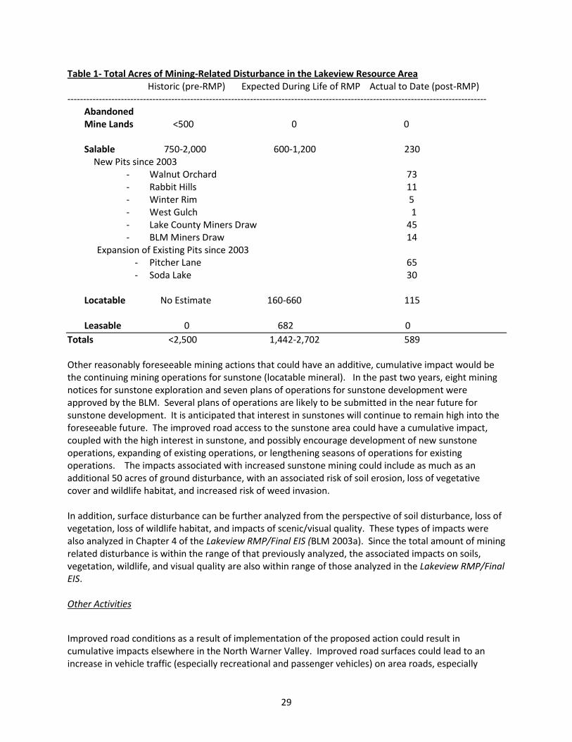
That said, the Lakeview Proposed RMP/Final EIS (BLM 2003a) contains a description of the overall environmental conditions (affected environment) within the Lakeview Resource Area (see Chapter 2) which is incorporated by reference and will not be repeated here. In addition, this EIS contains a discussion of the types of past mineral exploration and development activities that have occurred across the Lakeview Resource Area (BLM 2003a; pages 2-90 to 2-95) which provides a broader context within which to consider the potential incremental cumulative impacts of the two alternatives. Mining activity occurs in three distinct categories governed by different mining laws and regulations: salable, leasable, and locatable. The proposed quarry falls under the salable mineral category. A discussion of the cumulative impacts of all three mineral activities is included below.
Appendix N1 of the Draft Lakeview RMP/EIS (BLM2001), pages A-292 and A-293, summarized historic mineral activity within the resource area. In 1997 and 1998, 34 historic mining districts and two isolated prospect areas were inventoried to document historic, abandoned, or unreclaimed mining sites. A total of 491 small, individual abandoned workings were found, each generally under an acre in size. The majority of which are located in the Coyote Hills area immediately northwest of the proposed quarry. Abandoned mine workings are currently being reclaimed within the Lakeview Resource Area under the abandoned mine lands program at a rate of about one or two sites each year, based on site priority and funding. When new mineral development occurs in one of these old, abandoned sites, they are also reclaimed when the recent mineral development is done.
A discussion of locatable and leasable mineral exploration and development and historical activity is also included in the Lakeview Proposed RMP/Final EIS (BLM 2003a), pages 2-90 to 2-95, and in Appendix N2, pages A-209 to A-219. As of September 1999 (immediately prior to initiation of the Lakeview RMP), there were 368 active mining claims recorded in the resource area. Eighty percent of those claims were located in the Rabbit Basin sunstone area. The remaining claims were in the Tucker Hill perlite area and the Christmas Valley diatomaceous earth area. As of January 19, 2010, there were about 943 active claims on the Lakeview Resource Area.
In 1999, activity on active claims included 67 mining notices and two plans of operations. Disturbance for the mining notices averaged 2.3 acres per notice. Disturbance for mine development requiring plans of operations was changed in 43CFR3809 in 2001 and was required for producing mines that previously only required a mining notice. The Lakeview RMP/Final EIS (BLM 2003b) estimated an average of 67 mining notices and two mining plans would be open at any point in time during the life of the plan (with a total estimated disturbance ranging from 160 to 660 acres). Currently, there are a total of 43 open notices and 10 open mining plans of operation. Of the ten mining plans of operations only two exceed 5 acres in size: Tucker Hill Perlite Mine and Dust Devil Sunstone Mine.
Leasable mineral activity includes all energy minerals and sodium. In 1999, there was no leasable mineral activity. The Lakeview Proposed RMP/Final EIS (BLM 2003a), pages 2-90 to 2-95, and Appendix N2, pages A-215 to A-219, estimated that 2 to 4 oil and gas leases or geophysical activities would occur per year in the Lakeview Resource Area, potentially disturbing up to 670 acres. Up to four geothermal exploration actions per year were expected with approximately 12 acres of disturbance. Currently, neither oil or gas, nor sodium development activity has occurred since the plan was completed in 2003. However, four geothermal leases have been issued near the south end of Summer Lake. Though these leases cover about 2,510 acres, no notice has been issued nor has any exploration or development occurred to date. Therefore, none of these leases currently has any ground disturbance associated with it. Even if exploration occurs on some of these lease areas in the near future, ground disturbance would likely occur on less than 10% of the area (251 acres).
28
A detailed discussion of historic salable mineral activity is also included in Appendix N1, pages A-292 to A-297, of the Draft Lakeview RMP/E IS (BLM 2001). Within the Miners Draw area are several small, mined-out, partially reclaimed mineral pits (2 acres total) about 1,700 feet southeast from the project area (Map 1).
There are an estimated 50 to 100 existing sand, gravel, rock, and cinder pits scattered across the Lakeview Resource Area (Map M-3). These sites disturb an average of approximately 15 to 20 acres of land each, but may be as large as 40 acres. An authorized Common Use Area of 40 acres size is located approximately 3 miles to the northwest. The existing disturbance at this site is about 1 acre in size and is rarely used.
The Lakeview Proposed RMP/Final EIS (BLM 2003a) estimated and analyzed opening 15 to 30 new salable mineral sites, up to 40 acres in size each, over the life of the plan. This represents 600-1,200 acres of potential additional mining disturbance, the impacts of which are discussed in the secondary, indirect, and cumulative impacts section of the Final EIS on page 4-139. Since the RMP/ROD was completed, four new pits have been opened (Walnut Orchard, Rabbit Hills, West Gulch, and Winter Rim). A fifth pit (Miners Draw – Lake County Road Department) has been approved for development (Map 1). This represent a 45-acre mineral material site located about 800 feet to the east of the project area. The Lake County Road Department has not begun mining operations at this site.
These five new pits represent approximately 135 additional acres of new disturbance. In addition, the existing Pitcher Lane Lake County Free Use Permit (FUP) was expanded by 65 acres in 2007 and the existing Lake County Soda Lake FUP was expanded by 30 acres in 2004 for a total of 230 acres of new, authorized salable mineral disturbance since 2003.
8.3.B Present and Reasonably Foreseeable Future Actions Mining The proposed BLM Miners Draw Pit would be the sixth new salable mineral material pit to be opened or authorized since the RMP/ROD was completed in 2003 and represents an incremental cumulative effect of up to 14 additional acres of mining disturbance under the proposed action. Under the no action alternative, the new quarry would not be developed and no new additional acreage would be disturbed. However, up to 970 acres of additional salable mineral pit development would still be expected to occur in other parts of the Lakeview Resource Area (BLM 2003b) in response to future needs. It is likely that some of this additional pit development would occur elsewhere in the north Warner Valley. The estimated 244 acres of total new salable mining disturbance resulting from the five new pits, expansion of existing pits, and the proposed Miners Draw Quarry, the estimated 115 acres of locatable mineral disturbance are well within the range of mineral development impacts anticipated and previously analyzed within the Lakeview RMP/Final EIS (BLM 2003a; see Table). No disturbance has occurred to date within the four existing geothermal lease areas. In addition, the total amount of new mining related disturbance since completion of the RMP/ROD expected from all mining categories (salable, locatable, and leasable) would be small when considered within the context of the 3.2 million acres of public lands potentially available for mineral development and other multiple uses within the Lakeview Resource Area (see Table 1).
29
Table 1- Total Acres of Mining-Related Disturbance in the Lakeview Resource Area Historic (pre-RMP) Expected During Life of RMP Actual to Date (post-RMP) -------------------------------------------------------------------------------------------------------------------------------------
Abandoned Mine Lands <500 0 0 Salable 750-2,000 600-1,200 230 New Pits since 2003
- Walnut Orchard 73 - Rabbit Hills 11 - Winter Rim 5 - West Gulch 1 - Lake County Miners Draw 45 - BLM Miners Draw 14
Expansion of Existing Pits since 2003 - Pitcher Lane 65 - Soda Lake 30
Locatable No Estimate 160-660 115 Leasable 0 682 0
Totals <2,500 1,442-2,702 589 Other reasonably foreseeable mining actions that could have an additive, cumulative impact would be the continuing mining operations for sunstone (locatable mineral). In the past two years, eight mining notices for sunstone exploration and seven plans of operations for sunstone development were approved by the BLM. Several plans of operations are likely to be submitted in the near future for sunstone development. It is anticipated that interest in sunstones will continue to remain high into the foreseeable future. The improved road access to the sunstone area could have a cumulative impact, coupled with the high interest in sunstone, and possibly encourage development of new sunstone operations, expanding of existing operations, or lengthening seasons of operations for existing operations. The impacts associated with increased sunstone mining could include as much as an additional 50 acres of ground disturbance, with an associated risk of soil erosion, loss of vegetative cover and wildlife habitat, and increased risk of weed invasion. In addition, surface disturbance can be further analyzed from the perspective of soil disturbance, loss of vegetation, loss of wildlife habitat, and impacts of scenic/visual quality. These types of impacts were also analyzed in Chapter 4 of the Lakeview RMP/Final EIS (BLM 2003a). Since the total amount of mining related disturbance is within the range of that previously analyzed, the associated impacts on soils, vegetation, wildlife, and visual quality are also within range of those analyzed in the Lakeview RMP/Final EIS. Other Activities
Improved road conditions as a result of implementation of the proposed action could result in cumulative impacts elsewhere in the North Warner Valley. Improved road surfaces could lead to an increase in vehicle traffic (especially recreational and passenger vehicles) on area roads, especially
around the Sunstone Public Use Area and surrounding sunstone deposits. Initially, the road surface upgrades would require less maintenance, but increased traffic could lead to increased maintenance costs in the future. 9. List of Preparers Steve Flock Geologist and Lead Author Bill Cannon Archeologist Jayna Ferrell Range Management Specialist Brennan Hauk Weeds/Botany Breanna O’Connor Recreation Glenn Lorton Wildlife Biologist James Elvin Engineer Paul Whitman Planning and Environmental Coordinator Todd Forbes Natural Resource Specialist James Leal Fisheries/Hydrology/Riparian 10. References
BLM. 2001. Draft Lakeview Resource Management Plan/Environmental Impact Statement. USDI, BLM, Lakeview District, OR. 3 volumes. BLM. 2003a. Lakeview Proposed Resource Management Plan and Final Environmental Impact Statement. USDI, BLM, Lakeview District, Lakeview, OR. 4 volumes. BLM. 2003b. Lakeview Resource Management Plan and Record of Decision. USDI, BLM Lakeview Resource Area, Lakeview, OR. 2 volumes. BLM. 2004. Integrated Noxious Weed Management Program. EA#OR-010-2004-03. USDI, BLM Lakeview Resource Area, Lakeview, OR. BLM. 2008. H-1790-1 - National Environmental Policy Act Handbook. USDI, BLM, Washington Office, Washington, DC. BLM. 2010. Coyote Hills Wilderness Characteristics Evaluation. http://www.blm.gov/or/districts/ lakeview/plans/files/coyote_hills_wild_char_eval.pdf. USDI, BLM, Lakeview District, Lakeview Resource Area. Clark, Dennis, P.E. 2008. Flyrock and Forensic Investigations. OSM/Appalachian Region Technology Transfer Blasting Workshop Presentation. Climate Mitigation Services. 2007. Minnesota Steel Industries GHG Emissions Inventory. http://files.dnr.state.mn.us/input/environmentalreview/minnsteel/feis/comment_3.pdf. Forster, P., V. Ramaswamy, P. Artaxo, T. Berntsen, R. Betts, D.W. Fahey, J. Haywood, J. Lean, D.C. Lowe, G. Myhre, J. Nganga, R. Prinn,
30
31
G. Raga, M. Schulz and R. Van Dorland, 2007: Changes in Atmospheric Constituents and in Radiative Forcing. In: Climate Change 2007: The Physical Science Basis. Contribution of Working Group I to the Fourth Assessment Report of the Intergovernmental Panel on Climate Change [Solomon, S., D. Qin, M. Manning, Z. Chen, M. Marquis, K.B. Averyt, M.Tignor and H.L. Miller (eds.)]. Cambridge University Press, Cambridge, United Kingdom and New York, NY, USA.
GreenHouse Gas Online. Other Indirect Greenhouse Gases – Carbon Monoxide. http://www.ghgonline.org/index.htm Holbeck, T. 1981. Geology and Mineral Deposits of Coyote Hills Mining District, Lake County, Oregon. Oregon State University, Corvalis, OR. National Fleet Management Association (NAFA), Environmental Defense Fund (EDF). 2009. Fleet Greenhouse Gas Emissions Calculator. http://edf.org/documents/9591_fleet-calculator-reference.pdf NOAA Satellite and Information Service, Greenhouse Gases Frequently Asked Questions. http://www.ncdc.noaa.gov/oa/climate/gases.html. NRCS and BLM, Undated. Soil Survey of Lake County, Southern Part. 2 volumes. Oregon Department of Fish and Wildlife. 2005. Greater Sage-Grouse Conservation Assessment and Strategy for Oregon: A Plan to Maintain and Enhance Populations and Habitat. Oregon Department of Transportation. Undated. Rock Blasting and the Community, Geo-Technical Report. ftp://ftp.odot.state.or.us/techserv/Geo-Environmental/Material%20Sources/ Resources/Blasting_and_Community.pdf. PRISM Climate Group. 2010. Data Explorer (Coyote Hills, Oregon). http://gisdev.nacse.org/prism/nn/. [accessed 20 January 2010]. Taylor, G. 2009. Climate change. The Progressive Rancher. May 2009. 3 p. U.S. Environmental Protection Agency. Undated. Emission Facts: Average carbon Dioxide Emissions Resulting from Gasoline and Diesel Fuel. http://www.epa.gov/oms/climate/420f05001.htm. U.S. Environmental Protection Agency. 2009. Inventory of U.S. greenhouse gas emissions and sinks: 1990-2007. USEPA, Washington, DC. U.S. Fish and Wildlife Service. 2009. Final Rule. EA and Implementation Guidance. A permit for Take as Provided Under the Bald and Golden Eagle Protection Act (Eagle Act). U.S. Geological Survey. May 14, 2008 Memorandum to U.S. Fish and Wildlife Service.