Achieving Compliance with the Executive Order “Minimization Criteria” for Off-Road Vehicle Use on Federal Public Lands: Background, Case Studies, and Recommendations The Wilderness Society May 2016
Transcript
Achieving Compliance with the Executive Order
“Minimization Criteria” for
Off-Road Vehicle Use on Federal Public Lands:
Background, Case Studies, and
Recommendations
The Wilderness Society
May 2016
i
Executive Summary In response to the growing use of dirt bikes, snowmobiles, all-terrain vehicles, and other off-road
vehicles (ORVs)1 on federal public lands and corresponding environmental damage, social conflicts, and
public safety concerns, Presidents Nixon and Carter issued Executive Orders 11644 and 11989 in 1972
and 1977, respectively, requiring federal land management agencies to plan for ORV use based on
protecting resources and other recreational uses. Specifically, the executive orders require that areas
and trails designated for ORV use be located to minimize: damage to soil, watershed, vegetation, and
other public lands resources; harassment of wildlife and significant disruption of wildlife habitat; and
conflicts between ORV use and other existing or proposed recreational uses. While the Bureau of Land
Management (BLM) and U.S. Forest Service travel management regulations echo the executive order
“minimization criteria,” they do not provide guidance to field managers on how to apply the criteria.
It has been over four decades since Presidents Nixon and Carter obligated federal agencies to designate
a system of ORV areas and trails that minimize impacts. Yet the agencies consistently struggle to satisfy
that obligation, resulting in unnecessary damage to water, fish, wildlife, and the experience of other
visitors. This is evidenced by a series of court rulings finding agency failures to comply with the
minimization criteria. Those cases confirm the agencies’ substantive obligation to meaningfully apply
and implement – not just identify or consider – the minimization criteria when designating each area or
trail, and to show in the record how they did so.
In this report, we provide the policy framework for designating ORV trails and areas on federal lands,
along with a series of recommendations based on recent case law and ten case studies from the Forest
Service, BLM, and National Park Service that demonstrate both agency failures to comply with the
executive order minimization criteria and good planning practices that could be incorporated into a
model for application of the criteria.
We recommend that agencies issue guidance to clarify their obligations under the Executive Orders.
Specifically, when designating ORV trails and areas, agencies must:
(1) Actually minimize impacts – not just identify or consider them – and show how they did so in
the administrative record; and
(2) Apply a transparent and common-sense methodology for meaningful application of the
minimization criteria that provides opportunities for public participation, incorporates the best
available scientific information and best management practices, addresses site-specific and
larger-scale impacts, and accounts for monitoring and enforcement needs and available
resources.
The substantive obligation to minimize impacts applies to both ORV area allocations (typically made in
land management plans) and specific route designations (often made in travel plans). Guidance should
1 The Bureau of Land Management generally uses the term “off-highway vehicle” or “OHV,” which is synonymous
with off-road vehicle. For consistency across agencies and with the governing executive orders, this white paper uses the term ORV.
ii
also clarify that agency attempts to mitigate impacts associated with an existing ORV system are
insufficient to fully satisfy the executive order minimization criteria, which requires areas and trails to be
located to minimize impacts in the first instance.
There is an immediate need for agency leadership and direction to assist field managers with proper
implementation of the executive order minimization criteria and to provide necessary and appropriate
protection for our nation’s natural and cultural resources, ensure rewarding and safe recreational
experiences for all, and cure legal vulnerabilities. Guidance will also assist with implementation of
President Obama’s policy on mitigating impacts on natural resources, which complements and
reinforces the minimization criteria by requiring agencies to prioritize avoidance and minimization of
harmful effects to land, water, wildlife, and other ecological resources. The call for immediate action is
acute given that the Forest Service is embarking on comprehensive winter-time travel management
planning and the BLM hopes to complete hundreds of travel plans over the next five years.
Our hope is that this white paper serves to initiate a needed dialogue within and between land
management agencies that will result in enhanced agency commitment to and application of the
executive order minimization criteria. The Wilderness Society stands ready to collaborate to advance
these objectives.
1
Overview Presidents Nixon and Carter issued Executive Orders 11644 and 11989 in 1972 and 1977, respectively,
requiring federal land management agencies to minimize environmental impacts and conflicts
associated with the use of dirt bikes, snowmobiles, all-terrain vehicles, and other off-road vehicles
(ORVs)2 on federal public lands. Forty years later, the agencies continue to struggle to comply with the
executive order “minimization criteria,” as evidenced by a series of court rulings finding agency failures
to satisfy those criteria.
This white paper provides: (1) pertinent background information on ORV impacts and the agencies’ legal
obligations; (2) selected case studies from the U.S. Forest Service, Bureau of Land Management (BLM),
and National Park Service (NPS) highlighting lessons-learned from instances where the agencies have
failed to satisfy their duty to minimize impacts associated with ORV use, as well as instances of
successful planning practices, approaches, or outcomes that could be incorporated into a model for
application of the minimization criteria; and (3) recommendations for ensuring effective compliance in
the future, including suggestions for crafting clarifying guidance on proper application of the
minimization criteria.
It is important that the agencies address this issue as soon as possible to provide necessary and
appropriate protection for our nation’s natural and cultural resources, ensure rewarding and safe
recreational experiences for all, and cure legal vulnerabilities. The call for immediate action is acute
given that the Forest Service is embarking on comprehensive winter-time travel management planning
and the BLM hopes to complete hundreds of travel plans over the next five years.
The Wilderness Society is committed to identifying and implementing ways to advance land
management strategies to better protect and inspire Americans to care for our public lands. With this
white paper, we hope to initiate a needed dialogue within and between land management agencies that
will result in enhanced agency commitment to and application of the executive order minimization
criteria. As always, we stand ready to collaborate to advance these objectives.
I. Background
A. Impacts from ORV use While ORVs can provide important access and recreational enjoyment, over four decades of research
has documented significant adverse environmental and social impacts associated with their use on the
public lands. As the Council on Environmental Quality recognized in a 1979 Report, “ORVs have
damaged every kind of ecosystem found in the United States,” and “[f]ederal lands have borne a
disproportionate share of the damage.”
2 The Bureau of Land Management generally uses the term “off-highway vehicle” or “OHV,” which is synonymous
with off-road vehicle. For consistency across agencies and with the governing executive orders, this white paper uses the term ORV.
Impacts include physical resource damage such as soil and snow compaction, erosion, crushing of
vegetation, spread of invasive species, stream sedimentation, and air pollution. ORV use also degrades
and fragments wildlife habitat, diminishing resilience to climate change, while ORV noise, dust,
emissions, and the presence of humans disrupt wildlife processes such as breeding, feeding, migration,
and nesting. Damage to cultural and archaeological resources, including unintentional crushing of
artifacts and increased vandalism and looting, is also associated with ORV use. Finally, ORV use poses
public safety and user conflict concerns. In particular, the noise, dust, fumes, and physical resource
damage associated with ORV use can seriously impair the experience of the majority of public lands
visitors engaging in non-motorized forms of recreation.3
Advancements in ORV technology and changes in use patterns have exacerbated these impacts. In
addition, climate change is making public lands resources increasingly vulnerable to ORV-related
impacts, with changing and in many cases more intense storm events, altered wildlife habitat and
migration patterns, and other stressors intensifying resource damage.
B. Legal obligation to minimize impacts and conflicts with other uses In response to the growing use of ORVs and corresponding environmental damage and conflict,
Presidents Nixon and Carter issued executive orders to “establish policies and provide for procedures
that will ensure that the use of [ORVs] on public lands will be controlled and directed so as to protect
the resources of those lands, to promote the safety of all users of those lands, and to minimize conflicts
among the various uses of those lands.”4 To that end, the orders require federal agencies to plan for
motorized use based on protecting resources and other recreational uses.5 When designating areas or
trails available for ORV use, agencies must locate them to:
(1) minimize damage to soil, watershed, vegetation, or other resources of the public lands;
(2) minimize harassment of wildlife or significant disruption of wildlife habitats; and
3 For a selection of scientific studies, literature reviews, and other publications documenting these impacts, see,
e.g., S.C. Trombulak & C.A. Frissel, Review of Ecological Effects of Roads on Terrestrial and Aquatic Communities, Conservation Biology 14:18-30 (2000), available at http://onlinelibrary.wiley.com/doi/10.1046/j.1523-1739.2000.99084.x/pdf; The Wilderness Society, Science and Policy Brief, Habitat Fragmentation from Roads: Travel Planning Methods to Safeguard Bureau of Land Management Lands (May 2006, No. 2), available at https://partners.tws.org/wildscience/Publications1/Habitat%20Fragmentation%20from%20Roads.pdf; U.S. Government Accountability Office, GAO-09-509, Enhanced Planning Could Assist Agencies in Managing Increased Use of Off-Highway Vehicles (2009), available at http://www.gao.gov/assets/300/291861.pdf; T. Adam Switalski & Allison Jones, Off-road Vehicle Best Management Practices for Forestlands: A Review of Scientific Literature and Guidance for Managers, Journal of Conservation Planning 8:12-24 (2012), available at http://www.journalconsplanning.org/2012/JCP_v8_2_Switalski.pdf; Adam Switalski, Snowmobile Best Management Practices for Forest Service Travel Planning: A Comprehensive Literature Review and Recommendations for Management (2014), available at http://winterwildlands.org/wp-content/uploads/2015/02/BMP-Report.pdf; Saul L. Hedquist et al., Public Lands and Cultural Resource Protection: A Case Study of Unauthorized Damage to Archaeological Sites on the Tonto National Forest, Arizona, Advances in Archaeological Practice 2(4): 298-310 (2014). 4 Exec. Order No. 11644, § 1, 37 Fed. Reg. 2877 (Feb. 8, 1972), as amended by Exec. Order No. 11989, 42 Fed. Reg.
(3) minimize conflicts between off-road vehicle use and other existing or proposed recreational
uses of the same or neighboring public lands.6
The BLM and Forest Service travel management regulations echo these “minimization criteria” (although
they do not provide guidance to field managers on how to apply the criteria).7 The plain language of the
executive orders and agency regulations make clear that the criteria apply both to designations of areas
available for cross-country ORV travel and to designations of specific routes open to ORV use.8
Despite their long-standing legal obligation, the Forest Service, BLM, and NPS have struggled to properly
apply and implement the minimization criteria in their ORV planning decisions, prompting a suite of
federal court cases. Since 2009, federal courts have repeatedly invalidated travel management decisions
for agency failure to correctly apply the criteria to minimize resource damage and conflicts with other
recreational uses when designating ORV areas or trails:
Center for Biological Diversity v. BLM, 746 F. Supp. 2d 1055, 1071-81 (N.D. Cal. 2009) (record
provided no indication that BLM considered or applied the minimization criteria when designating
ORV routes in the West Mojave Desert).
Idaho Conservation League v. Guzman, 766 F. Supp. 2d 1056, 1071-74 (D. Idaho 2011) (record did
not reflect whether or how the Forest Service applied the minimization criteria in its travel plan for
the Salmon-Challis National Forest).
Defenders of Wildlife v. Salazar, 877 F. Supp. 2d 1271, 1304 (M.D. Fla. 2012) (NPS failed to articulate
or document whether or how it applied the minimization criteria to ORV route designations in Big
Cypress Preserve).
Central Sierra Environmental Resource Center v. U.S. Forest Service, 916 F. Supp. 2d 1078, 1094-98
(E.D. Cal. 2013) (Forest Service failed to show that it actually aimed to minimize environmental
damage when designating ORV routes in the Stanislaus National Forest).
The Wilderness Society v. U.S. Forest Service, No. CV08-363-E-EJL, 2013 U.S. Dist. LEXIS 153036, at
*22-32 (D. Idaho Oct. 22, 2013) (remanding the travel plan for a portion of the Sawtooth National
Forest where the agency relied on an unsupported conclusion that route closures and elimination of
cross-country travel minimized impacts).
6 Id. § 3(a). Section 3(a) also provides that “[a]reas and trails shall not be located in officially designated Wilderness
Areas or Primitive Areas” and “shall be located in areas of the National Park system, Natural Areas, or National Wildlife Refuges and Game Ranges only if the respective agency head determines that ORV use will not adversely affect their natural, aesthetic, or scenic values.” 7 43 C.F.R. § 8342.1 (BLM); 36 C.F.R. § 212.55(b) (Forest Service). NPS regulations provide that “[r]outes and areas
designated for off-road motor vehicle use [in national recreation areas, seashores, lakeshores, and preserves] shall be promulgated as special regulations” and “shall comply with . . . E.O. 11644.” 36 C.F.R. § 4.10(b). 8 Exec. Order 11644, § 3(a); 43 C.F.R. § 8342.1; 36 C.F.R. § 212.55(b); see also WildEarth Guardians v. U.S. Forest
Serv., 790 F.3d 920, 932 (9th Cir. 2015) (agency must apply the criteria “with the objective of minimizing . . . the effects of each particularized area and trail designation”); BLM Manual 1626.06(A)(2)(a) & (B) (agency must pay “[p]articular attention . . . to documentation of how the [minimization criteria] were considered in making [ORV] area designation decisions” and “in making individual road, primitive road, and trail designation decisions”).
4
Southern Utah Wilderness Alliance v. Burke, 981 F. Supp. 2d 1099, 1104-06 (D. Utah 2013) (agency
acknowledgment of the minimization criteria was insufficient where the record showed no analysis
of specific impacts of designated ORV routes in BLM’s Richfield Field Office).
Friends of the Clearwater v. U.S. Forest Service, No. 3:13-CV-00515-EJL, 2015 U.S. Dist. LEXIS 30671,
at *37-52 (D. Idaho Mar. 11, 2015) (Forest Service’s conclusory statements failed to show how it
selected ORV routes with the objective of minimizing their impacts in the Clearwater National
Forest).
WildEarth Guardians v. U.S. Forest Service, 790 F.3d 920, 929-32 (9th Cir. 2015) (Forest Service failed
to “apply the minimization criteria to each area it designated for snowmobile use” on the
Beaverhead-Deerlodge National Forest and to provide the “more granular analysis [necessary] to
fulfill the objectives of Executive Order 11644”).
Collectively, these cases confirm the agencies’ substantive obligation to meaningfully apply and
implement – not just identify or consider – the minimization criteria when designating each area or trail,
and to show in the record how they did so.
President Obama’s November 2015 memorandum on mitigating impacts on natural resources
complements and reinforces the minimization criteria. The memo articulates a policy for the
Departments of Interior and Agriculture “to avoid and then minimize harmful effects to land, water,
wildlife, and other ecological resources (natural resources) caused by land- or water-disturbing
activities, and to ensure that any remaining harmful effects are effectively addressed, consistent with
existing mission and legal authorities.”9 The memo requires each agency to develop and implement
guidance that establishes “a clear and consistent approach for avoidance and minimization of, and
compensatory mitigation for, the impacts of their activities and the projects they approve” that
accomplishes a “net benefit goal” (or, at a minimum, a no net loss) for important, scarce, or sensitive
natural resources.10
C. Immediate need for leadership and direction It has been over four decades since Presidents Nixon and Carter obligated federal agencies to designate
a system of areas and trails that minimizes impacts from ORV use. Yet the agencies still struggle to
satisfy that obligation. In 2004, then Forest Service Chief Dale Bosworth identified unmanaged
recreation as one of the “top four threats” to the national forests, and the next year promulgated
regulations requiring National Forest System units to restrict ORVs to a designated system of routes and
areas. This prompted the Forest Service to move quickly to complete summer-time ORV planning on all
but a handful of national forests; the agency is just now starting to tackle winter-time ORV planning.11
9 Presidential Memorandum: Mitigating Impacts on Natural Resources from Development and Encouraging Related
Private Investment, § 1 (Nov. 3, 2015), available at https://www.whitehouse.gov/the-press-office/2015/11/03/mitigating-impacts-natural-resources-development-and-encouraging-related. 10
Id. §§ 1, 3(b), 4. 11
In 2013, a federal court found that the Forest Service regulation allowing but not requiring designation of a system for over-snow vehicle use was inconsistent with the executive order requirement “to ensure that all [public] lands are designated for all off-road vehicles” in a way that minimizes resource damage and conflicts with
While the agency deserves kudos for expeditiously ending cross-country driving and, in certain
instances, elevating resource protection needs in its ORV designation decisions, it has generally failed to
apply and implement the minimization criteria. That failure has resulted in avoidable resource damage
and conflicts with other recreational uses.
In the BLM’s case, the agency has yet to develop ORV travel management plans for the majority of its
units. The agency, however, is embarking on an ambitious plan to complete nearly 500 travel plans by
2020.12 Like the Forest Service, the BLM has lost court challenges to early decisions based on its failure
to apply the minimization criteria. While the agency has generally failed to apply and implement the
minimization criteria, its ORV designation decisions in certain national monument units do appear to
minimize impacts to monument objects including cultural and archaeological resources and provide
examples of good planning practice that may be transferable.
On the Park Service side, dozens of national recreation areas, seashores, lakeshores, and preserves that
permit ORV use have yet to comply with the requirement to promulgate special regulations designating
areas and trails to minimize resource damage and recreational use conflicts, consistent with the
executive orders.13 As with the Forest Service and BLM, NPS ORV management has not escaped
litigation, and the agency’s special regulations often minimize impacts to park resources only where the
agency is under significant legal and political pressure.
Despite the string of court losses, the agencies have generally declined to issue clarifying guidance to
ensure that future ORV plans satisfy the substantive duty to minimize impacts and conflicts, as well as to
reduce their legal vulnerability.14 In the meantime, mismanaged ORV use continues to degrade soil, air,
and water quality, threaten imperiled wildlife species, impair climate change adaptation, and diminish
the experience of the majority of public lands visitors who enjoy the natural landscape through quiet,
non-motorized forms of recreation. The resulting resource damage, public safety concerns, and conflicts
also diminish the experience of ORV recreationists who do not want their use to unnecessarily harm the
other recreational uses. Winter Wildlands Alliance v. U.S. Forest Service, No. 1:11-CV-586-REB, 2013 U.S. Dist. LEXIS 47728, at *27-36 (D. Idaho, Mar. 29, 2013). In response, the Forest Service finalized a winter travel management rule in January 2015. The rule is codified at 36 C.F.R. part 212, subpart C and requires forests to designate a system of areas and trails for over-snow vehicle use that satisfies the minimization criteria. 12
See BLM, 2020 Travel and Transportation Management Vision (April 2015), available at http://www.blm.gov/style/medialib/blm/wo/Information_Resources_Management/policy/im_attachments/2015.Par.52719.File.dat/IM2015-060_att2.pdf. 13
36 C.F.R. § 4.10(b). On the winter-time side, NPS regulations prohibit snowmobile use except on designated routes and water surfaces that are used by motor vehicles during other seasons, and where those routes and water surfaces are designated for snowmobile use by special regulation. Id. § 2.18(c). 14
The agencies’ current directives governing travel management planning fail to provide any meaningful direction on application of the minimization criteria. For example, Forest Service Handbook 7709.55, ch. 10 does not address the minimization criteria, and Forest Service Manual 7715 lists “consider[ation of] the [minimization] criteria in 36 CFR 212.55” as one of seven “policy” objectives for travel management decisions, but then simply recites the language of the regulation. Forest Service Manual 7715.5(2). Similarly, BLM’s Travel and Transportation Management Manual 1626 simply cites 43 C.F.R. § 8342.1 [the minimization criteria] as providing the relevant criteria for designation of areas and routes and states that “the decision-making process must be thoroughly documented in the administrative record.” BLM Manual 1606.06(A)(2)(a) & (B).
environment or others’ enjoyment, and are concerned about being unfairly blamed for problems
resulting from mismanagement.
In this context, there is an immediate need for leadership and direction to assist field managers with
proper implementation of the executive order minimization criteria. This need is particularly urgent
given upcoming agency planning and policy initiatives. As mentioned above, the Forest Service is
commencing winter travel management planning under a new rule and is currently revising its directives
to reflect the mandate to plan for snowmobile use. It is important to make sure that the agency’s
approach to summer-time ORV planning is not a harbinger for similar non-compliance in upcoming
winter travel management planning. On the BLM side, the agency hopes to complete hundreds of new
travel management plans over the next five years. BLM is also currently revising its Travel and
Transportation Management Manual and Handbook and anticipates a 2016 rollout of its “Planning 2.0,”
which likely will adopt the common practice of severing land use planning (where ORV areas generally
are designated) from travel management planning (where ORV routes typically are designated).
These initiatives each provide an immediate need and important opportunity for additional agency
guidance on application of the minimization criteria. More detailed guidance on how to apply the
minimization criteria will lead to better environmental protection, more rewarding and safer
recreational experiences for all, and more efficient and less expensive planning. Guidance will also assist
with implementation of President Obama’s mitigation policy, which complements and is consistent with
the executive order direction to minimize impacts. Agency guidance on application of the minimization
criteria and on implementation of the mitigation policy should reflect and reinforce one another.
The following case studies – which highlight both successes and failures – and recommendations offer
take-aways and next steps for correcting course and institutionalizing policies and practices to finally
satisfy the legal obligation first articulated by President Nixon over forty years ago.
II. Case Studies The following case studies from the Forest Service, BLM, and NPS highlight individual elements of
selected travel or resource management plans that make ORV area and/or trail designations. The case
studies are not intended to be comprehensive or representative either in the selection of plans or in the
description of plan elements. Rather, they are intended to highlight: (1) problematic approaches that fail
to comply with the ORV executive orders and must be avoided in the future, and (2) examples of good
planning practices that could be incorporated into a model for application of the minimization criteria.
Importantly, the case studies highlighting good planning practices are not the result of the agencies’
application of the minimization criteria. In fact, The Wilderness Society and partner organizations have
struggled to identify any Forest Service or BLM ORV designation decisions that show effective
application of the minimization criteria. Nevertheless, the case studies highlight some positive trends,
practices, approaches, or outcomes that may be transferable to agency efforts to correct course and
finally achieve compliance with the executive orders.
7
The case studies, which are attached as an appendix, are as follows:
A. Forest Service 1. Salmon-Challis National Forest Travel Management Plan, pp. A-1 – A-2
2. Clearwater National Forest Travel Management Plan, pp. A-3 – A-4
3. White River National Forest Travel Management Plan, pp. A-5 – A-7
4. Sawtooth National Forest, Minidoka Ranger District Travel Management Plan, pp.
A-8 – A-10
5. Beaverhead-Deerlodge National Forest Land & Resource Management Plan, pp. A-
11 – A-12
B. BLM 6. Richfield Field Office Resource Management Plan and Travel Management Plan, pp.
A-13 – A-15
7. West Mojave Resource Management Plan Amendment and Route Designation
Project, California Desert Conservation Area, pp. A-16 – A-17
8. Sonoran Desert and Ironwood Forest National Monument Resource Management
Plans, pp. A-18 – A-19
C. National Park Service 9. Yellowstone National Park Winter Use Plan and Special Regulation, pp. A-20 – A-22
10. Cape Hatteras National Seashore ORV Management Plan and Special Regulation, pp.
A-23 – A-24
III. Recommendations There is an immediate need for agency leadership and direction to ensure that ongoing and future travel
management planning efforts satisfy the executive order obligation to minimize resource damage and
recreational use conflicts associated with ORV use. The most obvious and effective approach is for the
agencies to issue guidance that clarifies their obligation to: (1) actually minimize impacts – not just
identify or consider them – when designating areas and trails for ORV use, and show how they did so in
the administrative record; and (2) apply a transparent and common-sense methodology for meaningful
application of the minimization criteria that provides opportunities for public participation, incorporates
the best available scientific information and best management practices, addresses site-specific and
larger-scale impacts, and accounts for monitoring and enforcement needs and available resources. We
address each of these elements below, capitalizing on the take-aways from the case studies.
A. Substantive duty to minimize impacts and conflicts As a threshold matter, agency guidance should clarify that agencies must minimize impacts – not just
identify or consider them – when designating areas or trails for ORV use, and demonstrate in the
8
administrative record how they did so.15 In other words, the record must show how the minimization
criteria were “implemented into the decision process.”16 As the Ninth Circuit recently held, “[w]hat is
required is that the [agency] document how it evaluated and applied [relevant] data on an area-by-area
[or route-by-route] basis with the objective of minimizing impacts.”17 This substantive obligation is
consistent with President Obama’s mitigation policy requiring agencies to avoid and minimize harmful
impacts to achieve no net loss of – and ideally a net benefit to – important natural resources.18
As the case studies and litigation outcomes highlight, there are few examples of agency compliance with
that substantive mandate – and numerous examples of agency failures. The NPS’s ORV designations and
management in Yellowstone National Park and Cape Hatteras National Seashore, however, provide
examples of what it might look like to minimize impacts to sensitive wildlife, air quality, and non-
motorized uses. And while not an application of the minimization criteria, the BLM’s impacts analysis
and designation of ORV routes to protect and enhance certain natural and cultural resources in the
Sonoran Desert and Ironwood Forest National Monuments also provide examples of what compliance
with the substantive duty to minimize impacts might look like. Finally, the Clearwater National Forest’s
analysis and decision to close recommended wilderness areas to ORV use demonstrates minimization of
impacts to the forest’s wilderness resources and associated values and uses.
B. Mitigation of impacts Guidance should also clarify that agency attempts to mitigate impacts associated with an existing ORV
system are insufficient to fully satisfy the duty to minimize impacts, as specified in the executive orders.
The language of the executive orders makes this clear: “[a]reas and trails shall be located to minimize”
impacts and conflicts.19 Thus, application of the minimization criteria should be approached in two
steps: first, the agency locates areas and routes to minimize impacts, and second, the agency establishes
site-specific management actions to further reduce impacts. The best available science confirms this
tiered approach, as does President Obama’s mitigation policy, which articulates a hierarchy of first
15
As the courts have routinely held, agencies must document in the administrative record how their ORV designation decisions minimize resource damage and conflicts with other recreational uses. Importantly, that procedural duty – which is grounded in the Administrative Procedure Act – is both related and in addition to the substantive duty to minimize impacts. In other words, agencies may not remedy substantive violations of the executive orders simply by providing additional explanation in the record to justify the same designation decisions. Unfortunately, that approach is something we have seen on remand from court decisions finding such violations, including in BLM’s Richfield Field Office, on the Minidoka Ranger District of the Sawtooth National Forest, and on the Beaverhead-Deerlodge National Forest. 16
Idaho Conservation League, 766 F. Supp. 2d at 1072-74 (explaining that “[t]he whole goal or purpose of the exercise is to select routes in order to minimize impacts”); see also, e.g., Center for Biological Diversity, 746 F. Supp. 2d at 1080-81 (“BLM is required to place routes specifically to minimize” impacts). 17
WildEarth Guardians, 790 F.3d at 931 (emphasis added); see also id. at 932 (“consideration” of the minimization criteria is insufficient; rather, the agency “must apply the data it has compiled to show how it designed the areas open to snowmobile use ‘with the objective of minimizing’” impacts). 18
Exec. Order 11644, § 3(a); see also Center for Biological Diversity, 746 F. Supp. 2d at 1080-81 (“’Minimize’ as used in the regulation . . . refers to the effects of route designations, i.e. the BLM is required to place routes specifically to minimize ‘damage’ to public resources, ‘harassment’ and ‘disruption’ of wildlife and its habitat, and minimize ‘conflicts’ of uses.” (footnote and citations omitted)).
avoiding and minimizing impacts through proper project siting and design, and only then considering
additional measures to mitigate any remaining harmful effects.20
The relative importance of the two steps may vary according to the specific circumstances of the land
management unit. In some instances, the implementation of mitigation measures may be very
important to the overall minimization effort, while in others the initial placement and designation of
ORV areas and routes may dominate. Examples of the former include the Park Service’s science-based,
adaptive management approaches at Yellowstone National Park and Cape Hatteras National Seashore.
An example of the latter is the Clearwater National Forest, where the agency decided to remove ORVs
from recommended wilderness altogether.
The distinction between mitigation and minimization has generally eluded the agencies. For example,
the instruction memorandum from BLM’s Utah State Office appears to sanction an inappropriate
mitigation approach, directing agency staff to identify “recommended mitigation measures to minimize
user and resource conflicts for each alternative.”21 Similarly, on remand from a court decision
overturning its 2008 travel plan, the Minidoka Ranger District of the Sawtooth National Forest – rather
than revisiting its designation decisions – has focused exclusively on monitoring and maintenance of the
designated system.22
C. Application of minimization criteria to area allocations Guidance should also clarify that the agencies must satisfy their substantive duty to minimize impacts
when making both ORV area allocations (typically made in land management plans) and specific route
designations (often made in travel plans). The plain language of the executive orders and agency
regulations clearly require this, yet we have seen the agencies make area allocations with even more
disregard for the minimization criteria than in the route designation context.23 Minimization of impacts
associated with area designations is particularly important in winter travel management planning,
where snowmobiles are often permitted to travel freely throughout large open areas, rather than being
confined to specific routes.24 In overturning the Forest Service’s land management plan decision to
20
See Switalski and Jones, 2012 (cataloguing best management practices for: (1) siting/locating routes to minimize impacts; (2) implementation, including maintenance, restoration, adaptive management, and other mitigation measures; and (3) monitoring); Presidential Mitigation Memorandum, §§ 1, 2(f). 21
See Richfield Field Office case study, pp. A-13 – A-15 of this report. 22
See Sawtooth National Forest, Minidoka Ranger District case study, pp. A-8 – A-10 of this report. BLM’s proposed route network in the West Mojave Desert is a particularly egregious example: it would designate a massive and damaging ORV route network and then attempt to mitigate the impacts associated with its over 10,000-mile network if and when a complicated set of triggers are met. See West Mojave case study, pp. A-16 – A-17 of this report. 23
For example, BLM’s 2011 Resource Management Plan for the Little Snake Field Office designated as open to cross-country ORV travel nearly 20,000 acres in the South Sand Wash Basin Special Recreation Management Area despite the presence of significant cultural sites vulnerable to ORV damage and other sensitive resources including a wild horse herd. 24
The Forest Service’s winter travel management rule permits open area designations to be significantly larger than in the summer travel planning context, and it does not explicitly require analysis of individual routes within those large open areas. See 36 C.F.R. § 212.1 (definition of “area”).
allocate over 60% of the Beaverhead-Deerlodge National Forest to snowmobile use, the Ninth Circuit
Court of Appeals recently confirmed that the agency is required “to apply the minimization criteria to
each area it designate[s] for snowmobile use.”25
We also understand that BLM’s upcoming Planning 2.0 likely will sever land use planning (and associated
ORV area allocations) from travel management planning designed to designate specific routes – an
approach that is already commonplace. With area allocation decisions made in land use plans setting
the framework for where route designations will occur in travel plans (and often leaving large swaths of
land open to cross-country motorized travel, with no future decision-making required to authorize that
use), proper application of the minimization criteria at both scales is important and required.
D. Key elements of recommended methodology In order to achieve compliance with the substantive duty to minimize impacts associated with area and
trail designations, the agencies must apply a transparent and common-sense methodology for
meaningful application of each minimization criterion. Federal court decisions and the case studies in
this white paper highlight necessary elements of that methodology, which are described below and
should be included in agency guidance.
First, application of the minimization criteria is not solely an office exercise. As the courts have
repeatedly made clear, use of cryptic spreadsheets or matrices that favor ORV use and do not facilitate
implementation of the substantive duty to minimize impacts is inadequate.26 Rather, agencies should
get out on the ground, gather site- and resource-specific information, ground-truth desk-top analyses,
and then utilize that data to actually apply the criteria to minimize resource damage and use conflicts
associated with each designated area and route.
The Salmon-Challis National Forest provides a telling example. There, the court invalidated the agency’s
route designations that failed to utilize monitoring and other site-specific data showing resource
damage.27 On remand, however, the agency used existing data and gathered additional site-specific
information to actually assess the impacts of each route, resulting in closures of routes causing resource
damage. The story on the Sawtooth National Forest is not as promising. There, the agency has taken the
troubling approach on remand that it need not apply each minimization criterion to each designated
route and instead may rely on compliance with the governing land and resource management plan as a
proxy for satisfying its obligations under the executive orders.28 A federal court recently invalidated that
approach in a challenge to another travel management plan: “[m]erely concluding that the proposed
action is consistent with the Forest Plan does not . . . satisfy the requirement that the Forest Service
25
WildEarth Guardians, 790 F.3d at 930. 26
See, e.g., Idaho Conservation League, 766 F. Supp. 2d at 1071-74 (agency may not rely on “Route Designation Matrices” that fail to show if or how the agency selected routes with the objective of minimizing their impacts); S. Utah Wilderness Alliance, 981 F. Supp. 2d at 1105 (“cryptic spreadsheet for each route segment provides inadequate information . . . for someone other than the BLM to know why or how the routes were chosen”). 27
Idaho Conservation League, 766 F. Supp. 2d at 1074-77. 28
Land and resource management plans are designed to provide long-term, forest-wide management direction – not to satisfy the executive order minimization criteria. See 16 U.S.C. § 1604; 36 C.F.R. part 219, subpart A.
11
provide some explanation or analysis showing that it considered the minimizing criteria and took some
action to minimize environmental damage when designating routes.”29 This is just one example where
clear agency guidance could avoid duplicative mistakes.
The type of site-specific information will vary depending on the area and resources at stake. For
example, at Cape Hatteras National Seashore, the National Park Service conducts daily monitoring of sea
turtle and bird nesting sites along designated ORV routes, and implements temporary route closures as
necessary to protect those resources. In the Ironwood Forest National Monument, BLM conducted on-
the-ground inventories for archaeological and cultural resources along routes proposed for designation
to gather the information necessary to determine which routes to designate as open and which to close.
By contrast, a federal court invalidated BLM’s route designations in the Richfield Field Office in part
because the agency failed to conduct such inventories.30 Absent inventory data, agencies lack the
information necessary to locate designated routes to minimize impacts to cultural resources.
Second, effective application of the minimization criteria must include meaningful opportunities for
public participation and input early in the planning process.31 In many cases, public lands users and
other stakeholders are the best source of information for identifying resource and recreational use
conflicts. As illustrated in the litigation over the Salmon-Challis National Forest travel plan, agencies
disregard site-specific information submitted by the public at their peril. At the same time, it is
important that agencies assess the reliability and accuracy of information they receive, and
independently verify the information as needed. In certain circumstances, collaborative processes such
as the Vail Pass Task Force on the White River National Forest may provide valuable recommendations
or information.
Third, application of the minimization criteria should be informed by the best available scientific
information and associated strategies and methodologies for minimizing impacts to particular
resources.32 In 2012, the Journal of Conservation Planning published a literature review and best
management practices (BMPs) for ORVs on national forest lands.33 The BMPs provide guidelines, based
on peer-reviewed science, for ORV designation decisions, implementation actions, and monitoring
activities that are intended to minimize impacts to soils, water quality, vegetation, and wildlife, and
conflicts with other recreational uses. Winter Wildlands Alliance recently published a similar literature
review and BMPs for winter travel planning on national forest system lands, which is currently
Friends of the Clearwater, 2015 U.S. Dist. LEXIS 30671, at *46. 30
The court’s decision that BLM’s failure to conduct on-the-ground inventories violated the National Historic Preservation Act is currently on appeal. 31
See Friends of the Clearwater, 2015 U.S. Dist. LEXIS 30671, at *24-30, 40-52 (agency failed to consider best available science on impacts of motorized routes on elk habitat effectiveness or to select routes with the objective of minimizing impacts to that habitat and other forest resources). 33
the minimization criteria – should reference and incorporate these BMPs.35 Although they were
formulated for national forest lands, many of the BMPs may be applicable to ORV designation decisions
on BLM and NPS lands as well.
In addition to generalized BMPs, application of the minimization criteria should incorporate any relevant
site- or resource-specific scientific information or analysis. For example, Yellowstone National Park not
only compiled and incorporated the best available scientific information related to snowmobile use and
park resources – even convening a scientific advisory team to provide guidance on those efforts – but it
also conducted additional scientific studies to fill information gaps on air quality, soundscapes,
snowpack chemistry, and socioeconomic impacts. The ORV management plan for Cape Hatteras
National Seashore incorporates management strategies to minimize impacts to imperiled sea turtles and
birds based on standards contained in state and federal recovery plans and other peer-reviewed,
scientific studies. And the White River National Forest conducted a detailed analysis of recreational use
conflicts that assessed factors such as the quality of recreational experiences, average travel distances
and terrain needs for motorized versus non-motorized users, crowding, user trends and demands, and
locations and availability of access points and staging areas.
Fourth, proper application of the minimization criteria must address both site-specific and larger-scale
impacts.36 For example, agencies should assess and minimize landscape-scale impacts such as habitat
fragmentation, cumulative noise and air and water quality impacts, and degradation of wilderness-
quality lands and associated opportunities for primitive forms of recreation. Even to the extent they
have considered or applied the minimization criteria, the agencies have generally failed to assess and
minimize these larger-scale impacts. The Clearwater National Forest’s analysis of ORV impacts on
recommended wilderness areas, however, did address landscape-scale impacts such as disturbance of
long-term ecological processes and sights and sounds that degrade the areas’ naturalness and
opportunities for solitude. Similarly, Yellowstone National Park analyzed the effects of snowmobile use
on park resources at the site-specific and landscape scales and in the short- and long-term, looking, for
example, at long-term population dynamics and range-wide displacement of bison and elk, in addition
to shorter-term behavioral and physiological responses.
Finally, proper application of the minimization criteria should take into account available resources for
monitoring and enforcement, as well as any measures designed to further reduce and mitigate
impacts.37 For example, the chaotic and damaging situation in the West Mojave Desert highlights the
35
The Bitterroot National Forest recently referenced and applied BMPs from Switalski and Jones, 2012 in its Decision Notice/Finding of No Significant Impact for a project involving the designation of ORV trails. See Darby Lumber Lands Phase I – Decision Notice and Finding of No Significant Impact, pp. 13-14. 36
See, e.g., Idaho Conservation League, 766 F. Supp. 2d at 1066-68, 1074-77 (invaliding travel plan that failed to consider aggregate impacts of short motorized routes on wilderness values or site-specific erosion and other impacts of particular routes). 37
As described above, adopting measures designed to mitigate impacts associated with ORV use alone is insufficient to satisfy the agencies’ obligation under the executive orders to locate designated areas and trails to minimize resource damage and conflicts with other recreational uses. Where mitigation measures assist the agency in satisfying its minimization duty under the executive orders, however, the agency should demonstrate a reasonable expectation that resources will be available to ensure their implementation.
importance of designating an ORV system that the agency is capable of enforcing and maintaining.
Conversely, the Park Service devotes significant resources to monitoring and enforcement at Cape
Hatteras National Seashore – including daily patrols for nesting sea turtles and birds and associated
temporary closures that are posted on-site and regularly updated on an interactive, online Google Earth
map. To ease enforcement obligations and ensure user compliance in the first place, ORV designation
decisions should establish clear boundaries and simple restrictions (posted on-site and depicted on a
widely available ORV area and route map) designed to minimize resource damage and conflicts with
other recreational uses, and should follow a consistent rubric that areas and routes are closed unless
marked open on a map. The clear delineations between motorized and non-motorized areas and trails in
the management plan for the Vail Pass Winter Recreation Area on the White River National Forest
provide a good example. The clear management direction at Vail Pass is further reinforced by robust
monitoring and enforcement by seasonal rangers funded through permit fees.
We recommend that the agencies explore and develop policies, guidance documents, and other tools
that incorporate these recommendations and ensure future compliance with the executive orders. The
Forest Service’s ongoing effort to update its directives to be consistent with the new winter travel
management planning rule, BLM’s ongoing revision of its Travel and Transportation Management
Manual and Handbook, the anticipated 2016 rollout of BLM’s Planning 2.0, and implementation of the
presidential memorandum on mitigation each provide immediate opportunities for the agencies to
incorporate useful guidance on the minimization criteria into their directives. In the short-term, it also
makes sense for agency directors to issue instructive memoranda explaining the agencies’
responsibilities under the executive orders.
IV. Conclusion It has been over four decades since President Nixon obligated the federal land management agencies to
minimize resources damage and recreational use conflicts associated with ORV use. With the Forest
Service embarking on winter travel planning and the BLM ramping up its travel planning efforts, it is
time for the agencies to provide leadership and direction to guide those processes and avoid additional
litigation. We look forward to assisting the agencies with that effort and hope that the
recommendations in this white paper provide a solid starting point.
Please contact Alison Flint (303.802.1404, [email protected]) with any questions.38
38
The following Wilderness Society staff and volunteer interns contributed substantially to the content and production of this white paper: Alison Flint, Vera Smith, Phil Hanceford, Nada Culver, Scott Miller, Barbara Young, Josh Hicks, Brad Brooks, and Louisa Eberle.
prohibitions in recommended wilderness in place.39
Take-Aways
Analysis demonstrated that motorized use was
impairing wilderness character of recommended
wilderness, resulting in closures. Forest Service
recognized that designating motorized use in
recommended wilderness impairs its wilderness
suitability because Congress is unlikely to designate
those areas after motorized uses become established.
Forest Service took initiative to proactively address
winter-time ORV use and minimize impacts associated
with snowmobile use in recommended wilderness
areas.
39
Another lawsuit challenging other, less protective elements of the forest’s 2011 travel plan resulted in a 2015 court decision invalidating the travel plan for failure to apply and implement the minimization criteria and to comply with governing forest plan standards designed to protect wildlife habitat. Friends of the Clearwater v. U.S. Forest Service, No. 3:13-CV-00515-EJL, 2015 U.S. Dist. LEXIS 30671 (D. Idaho Mar. 11, 2015). The entire plan is now back before the agency.
Travel Management Plan Minidoka Ranger District, Sawtooth National Forest, Idaho U.S. Forest Service
he easily accessible Minidoka
Ranger District of southern
Idaho’s Sawtooth National
Forest provides an abundance of
recreational opportunities, including
fishing, camping, pine nut gathering,
hiking, and rock climbing. Despite the
fact that less than 3% of recreation
visits to the Sawtooth in 2005 were
for ORV use, the Forest Service’s 2008
travel plan revision for the Minidoka
District designated nearly 2,000 miles
of ORV routes, including many
previously illegal, user-created trails
in sensitive and impaired watersheds,
riparian areas, and wildlife habitat.
The agency’s failure to minimize
resource damage and comply with the
Clean Water Act prompted
conservation groups to file – and win
– a lawsuit in federal court. Unfortunately, on remand, the Forest Service adopted an ill-conceived and
troubling approach that compliance with the governing land and resource management plan necessarily
satisfied its duty to minimize impacts associated with ORV
use.
Timeline
November 2007: Forest Service releases environmental
assessment (EA) for travel plan revisions in three
Sawtooth Ranger Districts.
December 2007: EPA comments that “there is no
alternative included that would reflect actual recreation
uses and priorities of the public,” “[a]ll proposed route
designations . . . appear to disproportionately favor
motorized recreation,” and “the number of miles of
roads and trails . . . could . . . have a substantial negative
impact on wildlife.”
T
“It goes without saying that reducing
ORV use is beneficial to resources.
That conclusion, however, has
already been reached by the laws
and regulations requiring this action.
What is required of the agency is an
analysis comprised of something
more than restating that
conclusion.” The Wilderness Society v.
U.S. Forest Service, 850 F. Supp. 2d
1144, 1168 (D. Idaho 2012).
Christ’s Indian Paintbrush, an exceptionally rare plant species found only on a single mountaintop in the Minidoka Ranger District and threatened by invasive weeds that can be spread by ORV use (credit: U.S. Forest Service)
the duty to minimize impacts under the executive orders, and compliance with plan direction does
not necessarily mean impacts from ORV designations have been minimized.40
Map depicting high density of motorized routes and seriously degraded watershed conditions (red = functioning
at unacceptable risk; yellow = functioning at risk; green = functioning appropriately; gray = no data) in the
Cassia Division of the Minidoka Ranger District, which includes nearly 500 miles of streams
40
A federal court explicitly rejected this approach in a March 2015 decision invalidating a different travel management plan. Friends of the Clearwater v. U.S. Forest Service, No. 3:13-CV-00515-EJL, 2015 U.S. Dist. LEXIS 30671, at *46 (D. Idaho Mar. 11, 2015) (“Merely concluding that the proposed action is consistent with the Forest Plan does not, however, satisfy the requirement that the Forest Service provide some explanation or analysis showing that it considered the minimizing criteria and took some action to minimize environmental damage when designating routes.”).
A-11
Land & Resource Management Plan Beaverhead-Deerlodge National Forest, Montana U.S. Forest Service
outhwestern Montana’s Beaverhead-Deerlodge National Forest is nationally renowned for its
trout streams, large elk populations, and exceptional backcountry recreation opportunities. As the
largest national forest in Montana, its island mountain ranges and diverse ecosystems provide key
habitat linkages to the Greater Yellowstone Ecosystem for wide-ranging and imperiled species such as
grizzly bear, Canada lynx, and wolverine. As a mecca for winter recreation, the forest has experienced an
explosion in snowmobile use over the past decades, with more powerful modern machines able to
travel further and faster into previously inaccessible areas. Catering to that use, the Forest Service’s
2009 revised forest plan permitted snowmobile travel across more than 2 million acres (or
approximately 60% of the forest), including in sensitive wildlife habitat and favorite areas for skiers and
snowshoers. Conservation groups successfully challenged that decision, leading to the first appeals court
decision invalidating ORV designations that fail to satisfy the executive order duty to minimize resource
damage and conflicts with other recreational uses. The seminal court opinion conclusively establishes
the substantive nature of the agencies’ obligation to meaningfully apply and implement – not just
consider – the executive order minimization criteria when designating each area and trail for ORV use.
Timeline
2002: Forest Service initiates forest plan
revision.
January 2009: Forest Service finalizes revised
forest plan, acknowledging that “the
unmanaged expansion of motorized uses[,
including snowmobiles,] has resulted in
resource damage, wildlife impacts, and
competition and conflict between user groups,”
yet still allocating over 60% of the forest to
S
“What is required is that the Forest Service
document how it evaluated and applied the
[relevant] data on an area-by-area [and
route-by-route] basis with the objective of
minimizing impacts . . . .” WildEarth
Guardians v. U.S. Forest Service, 790 F.3d
920, 931 (9th Cir. 2015).
Miner Ridge in the Hellroaring Basin, Mt. Jefferson Roadless Area (credit: Forrest McCarthy)
cross-country travel by snowmobiles. The plan did close recommended wilderness to motorized
uses.41
September 2010: Conservation groups file suit in federal court.
June 2015: Ninth Circuit Court of Appeals invalidates the 2009 decision, finding no evidence in the
record that the agency applied and implemented the minimization criteria when designating areas
for snowmobile use. The decision specifically adopts the rationales from earlier district court
decisions also invalidating
BLM and Forest Service travel
management decisions.
WildEarth Guardians v. U.S.
Forest Service, 790 F.3d 920,
929-32 (9th Cir. 2015).
Take-Aways
Agencies must apply and
implement – not just consider
– the minimization criteria on
an area-by-area and route-by-
route basis, providing a
“granular” analysis that
applies relevant data to show
how areas and trails are
designed to minimize impacts.
Agencies may not rely on
forest-wide reductions in total open acreage or route mileage, or on plan-wide data or general
decision-making principles. Rather, the minimization criteria are concerned with the effects of area
and trail designations.
The minimization criteria apply with force to area allocations made in land and resource
management plans, as well as to area and trail designations made in specific travel management
plans.
41
A federal court upheld the decision to exclude motorized uses from recommended wilderness. Beaverhead County Commissioners v. U.S. Forest Service, No. CV 10-68-BU-SEH, 2013 U.S. Dist. LEXIS 108196 (July 22, 2013).
Evidence of illegal snowmobile use in the Mt. Jefferson Roadless Area
(credit: Forrest McCarthy)
Denning wolverine on the Beaverhead
Deerlodge (credit: Forrest McCarthy)
A-13
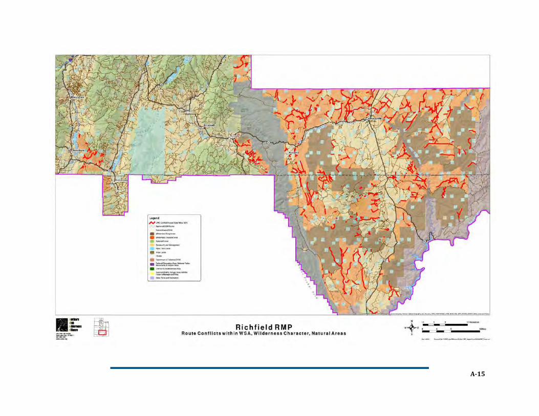
Resource Management Plan & Travel Management Plan Richfield Field Office, Utah Bureau of Land Management
LM’s Richfield Field Office encompasses
some of the Utah’s most iconic and
remote natural landscapes, including
the rugged Henry Mountains and the famed
Dirty Devil River. The region’s fragile desert soils
and vegetation, irreplaceable archaeological
sites, and scarce water resources are
particularly vulnerable to degradation caused by
ORV use. A federal court recently overturned
BLM’s 2008 travel plan designating over 4,000
miles of mostly user-created ORV routes –
enough miles to drive from Atlanta, GA to
Anchorage, AK – for its failure to minimize
impacts to those resources. While BLM’s Utah
State Office has shown leadership by issuing
additional guidance to assist the agency with travel planning for ORVs, that guidance falls short in its
interpretation of the legal duty to minimize impacts.
Timeline
October 2008: BLM finalizes its resource management plan
(RMP) and travel plan, designating over 4,000 miles of ORV
routes, with approximately 400 stream crossings, and nearly
10,000 acres of areas open to cross-country ORV travel.
November 2010: Conservation groups file suit in federal
court challenging the RMP and travel plan.42
August 2012: BLM’s Utah State Director issues an
instruction memorandum (IM 2012-066) providing
additional guidance for travel management planning.
November 2013: Court invalidates travel plan where the
record showed no analysis of specific impacts of designated
ORV routes. Southern Utah Wilderness Alliance v. Burke,
981 F. Supp. 2d 1099, 1104-06, 1107-1110 (D. Utah 2013).
42
The groups also challenged five other RMPs and travel plans finalized in 2008 that cover most of southern, central, and eastern Utah. The parties litigated the merits of the Richfield plan first as part of a “test-case” approach in the consolidated lawsuit. The remaining five challenges remain pending and unresolved.
management plan and special regulation, and a revised
interim management plan.
December 2010: NPS finalizes ORV management plan.
January-February 2012: NPS publishes special
regulation designating ORV routes and implements
2010 management plan, establishing:
o Permit requirement and restrictions on
permitted types and uses of ORVs;
o Seasonal and night-time driving restrictions for
wildlife protection; and
o Temporary route closures to implement species
management strategies including proactive pre-nesting closures and standard buffers
around nesting and fledging sites, resulting in daily updates to an interactive beach access
map on Google Earth and on-site signage.43
2012-2013: Record-breaking numbers of sea turtle nests recorded.
June 2014: Court upholds
management plan and special
regulation in challenge by
motorized access group. Cape
Hatteras Access Preservation
Alliance v. Jewell, No. 2:13-CV-
1-BO, 2014 U.S. Dist. LEXIS
84596 (E.D.N.C. June 19, 2014).
Take-Aways
Minimizing impacts to wildlife
and other resources, while continuing to permit ORV use, may require significant agency resources
in the form of monitoring, enforcement, and iterative processes to ensure resource protection.
Agencies should utilize the best available scientific information to inform application of the
minimization criteria (e.g., management strategies for imperiled species based on U.S. Fish &
Wildlife Service recovery plans, U.S. Geological Survey studies, state wildlife agency
recommendations, and other peer-reviewed information).
Agencies should provide significant opportunity for stakeholder and public participation early in the
ORV designation process to identify impacts and conflicts, and strategies to minimize them.
43
Pursuant to the National Defense Authorization Act for Fiscal Year 2015, Public Law No. 113-291, § 3057, the NPS recently adjusted wildlife buffers and is currently considering whether to make other modifications to the ORV management plan and special regulation. Due to this ongoing effort, the interactive map is not currently available, and the NPS is working to finalize a new format for delivering beach access information. See https://www.nps.gov/caha/learn/management/2015ndaact.htm.
Crowds view turtle hatching (credit: National Park Service)