Page 1
Mining plan for Mining of River Sand in Kangsabati River at Mouza Kenduapal -JLNo.106, Plot No 150(p) 151(p) &153(P) of Sri. Selim Saha
Prepared By K.T.Ramachandra. RQP, ULTRA-TECH Environmental Consultancy & Laboratory Page1
MINING PLAN
FOR MINING OF RIVER SAND
OF
SRI. SELIM SAHA S/O LATE KARIM SAHA
IN KANGSABATI RIVER BED AT MOUZA KENDUAPAL,J.L. No.106,PLOT No.150(P) 151(P)&153(P)
MIDNAPORE.P.S., PASCHIM MIDNAPORE, WEST BENGAL.
EXECUTIVE SUMMARY
Demand for river sand is enormously increased in building construction, good transport
road formation and in infrastructural developments. The river sand is stated vanishing
from the river beds besides causing natural and environmental hazards in surrounding
areas due to illegal and unsystematic way of mining without Proper Mining plan.
Systematic, Scientific and “Eco-Friendly “Mining/ Desilting of river sand will helping in to
avoid flood and also meet the sand requirement in building construction, good transport
road formation and in infrastructural developments. Hence west Bengal Govt. is
sanctioning the sand mining lease.
The Kangsabati or Kasai River is a major river system in the study area. It originates from
Chhotonagpur plateau and flows in the district Paschim Medinipur and conjoined with
Keleghai and falls into the Haldi River near Mahishadal. The river is navigable during
rainy season. River Kumari in Bankura and Cossye from Kapastikri in Paschim Medinipur
are the main tributaries of Kasai River. The river carries a large amount of silt causing
silting up the channel.
Sri.Selim Saha is residing Village Barmumibgarh, P.O. Janardanpur, P.S. Kharapur,
Paschim Midnapore. District west Bengal State. Sri. Selim Saha is mining river sand from
last one d and half decade and is having Vast experience in River sand Mining and
Trading and he was Sanctioned 19.07 acres Long Term Mining Lease in Kangsabati river
bed at Mouza Kenduapal J.L.No.106, plot No.150(p) 151(p)&153(p). Khargapur .P.S.
Paschim Midnapore District, West Bengal. The copy of the Long term lease Sensation
letter (Writ Possession) is enclosed as Annexure No.1.
Page 2
Mining plan for Mining of River Sand in Kangsabati River at Mouza Kenduapal -JLNo.106, Plot No 150(p) 151(p) &153(P) of Sri. Selim Saha
Prepared By K.T.Ramachandra. RQP, ULTRA-TECH Environmental Consultancy & Laboratory Page2
The copy of the Land Lease document is enclosed as Annexure No.2.
As per the orders of National green Tribunal Principal Bench, New Delhi, dated 05AUG
2013, the Ministry of Environment & Forest (MoEF) had issued an office Memorandum
vide no. J-13012/12/2013-IA.II (I) dated 24 th Dec.2013, stipulating that river sand mining
shall obtain the Environmental Clearance from MoEF or concerned State Environmental
impact Assessment Authority (SEIAA). As the case may be. To get Environmental
Clearance from Competent Authority, it is very much necessary to prepare Mining plan,
which is the base document also.
In view of the above Sri.Selim Saha contacted, Ultra-Tech Environmental consultancy &
Laboratoryservices is having his registered (HO) office at Khopat. Thane West & having a
Branch office at CG 229, Salt Lake, Sector-2, Kolkata-700091.Sri K.T. Ramachandra
Geologist & RQP and Sri. Debasish Sengutha, Environmental Engineer. Visited the site on
10/09/2016.The Mining Plan is duly prepared and certified by RQP and Submitted for
approval.
1.0. General Information about the applicant:-
SL No PARTICULARS DESCRIPTION
1. Name of the Lessee, Sri. Selim Saha
Address Barmunibgarh Village, Janardanpur.P.O. Kharagpur P.S. PaschimMidnapore.
District PaschimMidnapore
State West Bengal.
Phone 9051513950
Page 3
Mining plan for Mining of River Sand in Kangsabati River at Mouza Kenduapal -JLNo.106, Plot No 150(p) 151(p) &153(P) of Sri. Selim Saha
Prepared By K.T.Ramachandra. RQP, ULTRA-TECH Environmental Consultancy & Laboratory Page3
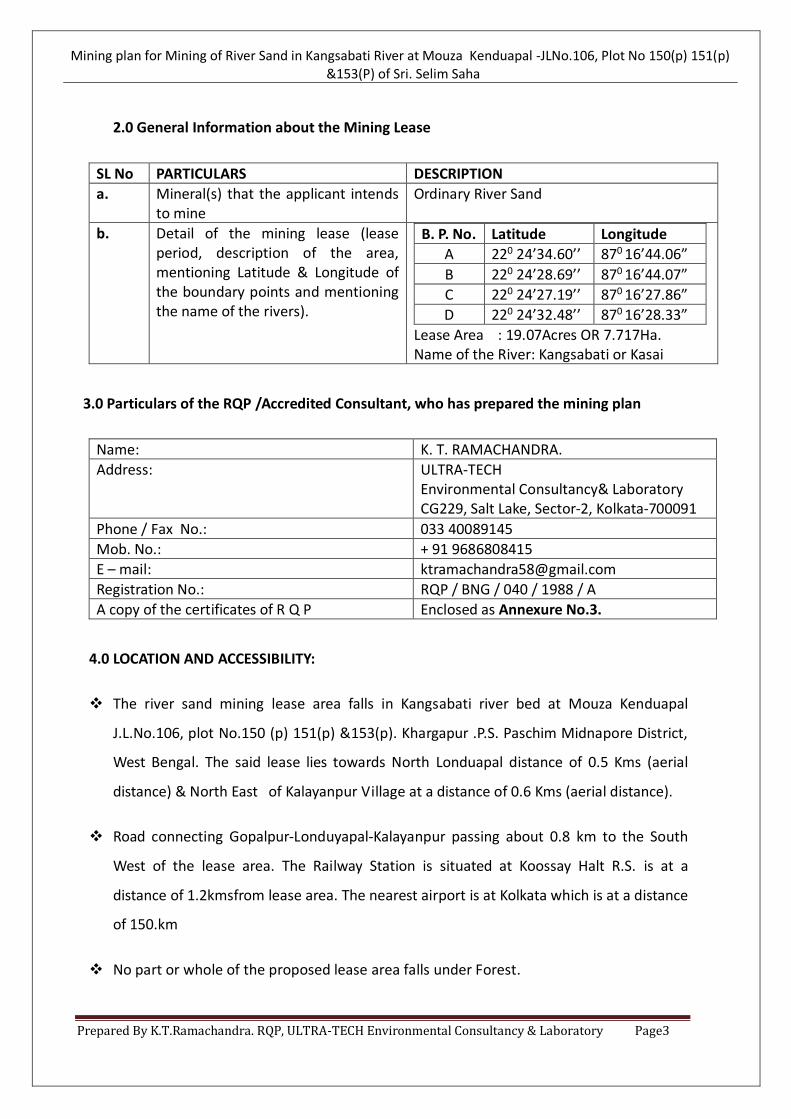
2.0 General Information about the Mining Lease
SL No PARTICULARS DESCRIPTION
a. Mineral(s) that the applicant intends to mine
Ordinary River Sand
b. Detail of the mining lease (lease period, description of the area, mentioning Latitude & Longitude of the boundary points and mentioning the name of the rivers).
B. P. No. Latitude Longitude
A 220 24’34.60’’ 870 16’44.06”
B 220 24’28.69’’ 870 16’44.07”
C 220 24’27.19’’ 870 16’27.86”
D 220 24’32.48’’ 870 16’28.33”
Lease Area : 19.07Acres OR 7.717Ha. Name of the River: Kangsabati or Kasai
3.0 Particulars of the RQP /Accredited Consultant, who has prepared the mining plan
Name: K. T. RAMACHANDRA.
Address: ULTRA-TECH Environmental Consultancy& Laboratory CG229, Salt Lake, Sector-2, Kolkata-700091
Phone / Fax No.: 033 40089145
Mob. No.: + 91 9686808415
E – mail: [email protected]
Registration No.: RQP / BNG / 040 / 1988 / A
A copy of the certificates of R Q P Enclosed as Annexure No.3.
4.0 LOCATION AND ACCESSIBILITY:
The river sand mining lease area falls in Kangsabati river bed at Mouza Kenduapal
J.L.No.106, plot No.150 (p) 151(p) &153(p). Khargapur .P.S. Paschim Midnapore District,
West Bengal. The said lease lies towards North Londuapal distance of 0.5 Kms (aerial
distance) & North East of Kalayanpur Village at a distance of 0.6 Kms (aerial distance).
Road connecting Gopalpur-Londuyapal-Kalayanpur passing about 0.8 km to the South
West of the lease area. The Railway Station is situated at Koossay Halt R.S. is at a
distance of 1.2kmsfrom lease area. The nearest airport is at Kolkata which is at a distance
of 150.km
No part or whole of the proposed lease area falls under Forest.
Page 4
Mining plan for Mining of River Sand in Kangsabati River at Mouza Kenduapal -JLNo.106, Plot No 150(p) 151(p) &153(P) of Sri. Selim Saha
Prepared By K.T.Ramachandra. RQP, ULTRA-TECH Environmental Consultancy & Laboratory Page4
5.0 PHYSIOGRAPHY, DRAINAGE & CLIMATE:
On the basic of the characteristics of the districts, the entire Midnapore district (Purba
and Paschim) has broadly been divided into two natural divisions –the western upland
including undulating lateritic Rarh plain and the eastern Gangetic alluvial plain along
with southern maritime tract. It is assumed that a metalled road passing from Raniganj
to Cuttack through undivided Midnapore district that cut across the district north to
south is the approximate boundary line of these two natural divisions. Physiographically,
the region has been sub-divided into three macro-regions and five micro-regions. The
macro-regions are:
a) The Western Upland
b) The Rarh.
c) The Plain (Deltaic and Coastal).
The micro-regions lies within these macro-regions are:
i. Medinipurupland
ii. Silaiplain
iii. Lower Kasai plain
iv. Contaiplain
v. Digha coastal plain
Lower Kasai plain:
Kasai is the main river in this region. The region extends over both the side of the Kasai
River. Being the largest plain area of undivided Midnapore district, the upper eastern
part is experienced with the deltaic nature while the lower northern part experiencing
the tidal influences; ebb and flow is very much active in this region. It is a long
depressed area characterized by low laying tract of alluvium. This is formed due to the
assimilation of the deltas of Kasai and Silai in the north-west portion which is triangular
in nature. The rate of alluvial deposition is very high as for the river bed of Kasai is
totally lost her navigability.
Page 5
Mining plan for Mining of River Sand in Kangsabati River at Mouza Kenduapal -JLNo.106, Plot No 150(p) 151(p) &153(P) of Sri. Selim Saha
Prepared By K.T.Ramachandra. RQP, ULTRA-TECH Environmental Consultancy & Laboratory Page5
General slope is noticed in this area is from NW-SE a sloppy undulating terrain. The flow
of the water is SE direction. Most of the River bed area covered fine grain to coarse
grain sand with rocky pebbles at places & there is no vegetation except grass at places.
The district is characterized by tropical day climate with a hot summer. The daily
maximum temperature in the hot summer is about 40 0cand annual rain fall is ranging
fron1400 -1800mm.
6.0. GEOLOGY OF THE AREA:
a) Regional Geology:
The terrain characteristic of the district (undivided Midnapore) is lateritic in the western
and north-western part while in southern and south-eastern part it is gradually changing
with alluvium deposit of Gangetic delta. In north-west and western portion is hilly
upland and several ridges are formed where micaceous schist carved out from the
beneath of lateritic outcrop. Grey and bluish-grey micaceous schists are found in the
ridges. The hills are separated by valley in an irregular manner. The hills are composed
of hard grey and grayish-white gritty quartzite whereas blue slater and traps are found
in the valleys.
The lateritic rocks are present in the undulating plain surface and it covers a large area.
The lateritic rocks area is slightly elevated from the adjoining alluvial plain. The gravelly
structure is found in most of the areas. The lateritic gravel and laterite covering areas
are characterized by dry, parched and stony soil which is not suitable for crop
cultivation. The upper laterite often enrooted by conglomeratic and pebbles of quartz or
somewhere it rests upon grayish white and reddish clay, soft soapy and felspathic rocks.
The clay beneath down the lateritic gravels is slightly saturated with iron. Most aberrant
phenomenal feature of geology of the district is the long and vast lateritic sheet found
into the dip of adjoining Gangetic plain and also the dip of western upland.
Page 6
Mining plan for Mining of River Sand in Kangsabati River at Mouza Kenduapal -JLNo.106, Plot No 150(p) 151(p) &153(P) of Sri. Selim Saha
Prepared By K.T.Ramachandra. RQP, ULTRA-TECH Environmental Consultancy & Laboratory Page6
b) Local Geology (Tectonics and structural behavior of rocks, description of formation,
lithology of catchment area,).
Most of the area is covered by ordinary river sand deposited decade back. The other
rock formation in area is alluvial rocky upland and undulating lateritic upland these
formations undergo series of metamorphic cycles, like weathering, erosion,
transportation and deposition of sand material.
The geological parameters / features of the ore body as obtained from the field mapping
and exploration studies reveal the following.
Length of the Deposit (Lease Area.) : 450-500 m
Width of the Deposit (Lease Area.) : 160-170m
Depth of the ore body : 1.5m-2 m.
A Surface Geological Map & Section showing the different litho units is mapped and the
cross-section showing the disposition of the different litho units are marked and
enclosed as Plate No. 5.
C ) Replenishment Study.
i) Origin and Control of mineralization
Sediment dispersal and accumulation patterns are governed by three basic effluent
forces and by tide- or wave-induced processes. Neglecting modifications by tides or
waves, effluent behavior and consequent depositional patterns depend on the relative
dominance of (1) outflow inertia, (2) turbulent bed friction seaward of the mouth, and
(3) outflow buoyancy.
The final source to be discussed is the alluvium of the Plains. Sheet and rill erosion of the
low gradient surface of the Plains is surprisingly high; between 500 and 1000 t km–2 yr–
1 , with ravine (gully) lands yielding ~ 3000 t km–2 yr–1 along river terrace margins
14,36. But there are no estimates of the Sediment Delivery Ratio for these parts of the
Ganga Basin.
Page 7
Mining plan for Mining of River Sand in Kangsabati River at Mouza Kenduapal -JLNo.106, Plot No 150(p) 151(p) &153(P) of Sri. Selim Saha
Prepared By K.T.Ramachandra. RQP, ULTRA-TECH Environmental Consultancy & Laboratory Page7
iii )Geomorphology
Geo-morphologically, the area represents flat topography with regional slope. The
district lies in the Ganges delta Plain. The Ganges delta consists of the whole
of Murshidabad district, Nadia, Kolkata, Hooghly, and Howrah and the northern part
of North and South 24 Parganas. River Ganges passes through this vast area and divides
into three distinct parts – the old delta, the mature delta and the active delta.
iv) Climate Zone, Rainfall, Drainage Pattern
A) Climate Zone
The area is experienced by a great variation in climatic characteristics. The climate is
very much tropical and exercising monsoonal characteristics with variations in micro-
regions. The climate of the northern and western part of the area is being characterized
by arid climate having a vicious dry heat in summer, a short winter season and
moderately rainfall. The climate of eastern and southern part is different in nature;
characterized by hot and humid climatic condition. The seasons are however well
marked for the entire area.
• Summer season – (March to May)
• South west Monsoon season – (June to September)
• Post-Monsoon season – (October to November)
• Winter season – (December to February)
B) Rain fall
The average annual rainfall occurs in the area is 1525.5 mm which is very much variable
in nature from place to place. Most of it occurs during monsoonal period. At least 74.0
percent of the total annual rainfall occurs in monsoonal period. The average annual
range of temperature varies from 25.5 °C to 38.6°C in Purba Medinipur whereas in
Paschim Medinipur it varies from 39.0°C to 10.0°C. The average annual rainfall occurs in
Purba Medinipur is 1697.0 mm whereas in Paschim Medinipur it is 1550.0 mm.
Page 8
Mining plan for Mining of River Sand in Kangsabati River at Mouza Kenduapal -JLNo.106, Plot No 150(p) 151(p) &153(P) of Sri. Selim Saha
Prepared By K.T.Ramachandra. RQP, ULTRA-TECH Environmental Consultancy & Laboratory Page8
C ) Drainage Pattren
The Kangsabati or Kasai River is a major river system in the study area. It originates from
Chhotonagpur plateau and flows in the district Paschim Medinipur and conjoined with
Keleghai and falls into the Haldi River near Mahishadal. The river is navigable during
rainy season. River Kumari in Bankura and Cossye from Kapastikri in Paschim Medinipur
are the main tributaries of Kasai River. The river carries a large amount of silt causing
silting up the channel.
iv) Sedimentation study.
The catchment of the combined Ganga–Brahmaputra rivers is 1.656 ´ 106 km2 in area,
yields ~ 1000 ´ 106 tonnes/yr of suspended sediment at a point ~ 200 km from the ocean
in Bangladesh2,3 (~ 8% of the total sediment load reaching the global oceans), and
appears to be the highest suspended sediment load of any river system in the world.
The Ganga–Brahmaputra rivers contribute almost all of the sediment making up the
Bengal Delta and Submarine Fan, a vast structure that extends from Bangladesh to south
of the Equator, is up to 16.5 km thick, and contains at least 1.13 ´ 1016 tonnes of
sediment4 accumulating over the last 17 ´ 106 years at an average rate of 665 ´ 106 t/yr.
From about 0.9 ´ 106 years ago, the rate of accumulation in the Bengal Fan has
increased by a factor of 4.5 from the previous 6 ´ 106 years, coincident with global
cooling and drying. The Fan has buried organic C at a rate since the early Miocene of ~
1.1 ´ 1012 mol/yr, representing between 10 and 25% of the total global burial flux of
organic carbon during this period.
Silt sediment in the River during the month of May to June 2016, a daily reading showed
0.8 cm increase in the deposit of silt inside the reservoir connected to the river. The
sediment level is higher and the same does not get washed away with low tide as the
water in the reservoir does not have current therefore allowing the sediment to settle
down. The reading was carried out during low tide. The river water was allowed to enter
in to private land. The study measuring sediment level is ongoing; the same shall be
concluded by October, 2016.
Page 9
Mining plan for Mining of River Sand in Kangsabati River at Mouza Kenduapal -JLNo.106, Plot No 150(p) 151(p) &153(P) of Sri. Selim Saha
Prepared By K.T.Ramachandra. RQP, ULTRA-TECH Environmental Consultancy & Laboratory Page9
a) Estimation of Geological Reserve & Grade
The parameters considered for estimation of reserves.
a) The total Sanctioned area for Mining of River Sand 7.717 Ha
b) The total area proposed for Mining of Brick earth/river silt is 7.360 Ha or 73600M2
c) Depth of the Mining allowed is 2.0m from the ground level.
d) Bulk density is taken 2.5.
Geological Reserves of river sand are tabulated below.
Total area in M2
Depth of pit In Mtr Volume in M3 Bulk Density Total MT
73600 2.0 1,47,200 2.5 3,68,000
Note: Every year silt will be removed and allow excavated pit for sedimentation. The
sedimentation study reveals that every day 0.8cms of silt will be filling in the proposed
area, hence mining activity only for four months rest 8 months allowed for
sedimentation of silts.
7.0. METHOD OF MINING IN DETAIL:-
a) Category of mine (A/B1/B2)- B2 :
The proposed River Silt is >than 5.0 Ha, hence this project comes under Category-B1.
b) Year wise development plan.
The sedimentation in every year is about 1,40,000 M3. Year wise production for plan
period is tabulated below.
Year Area in M2
Depth/Bench Height Area in M3 Bulk Density Total in MT
1st Year 70000 2 1,40,000 2.5 3,50,000
2nd Year 65000 2 1,30,000 2.5 3,37.500
3rd Year 65000 2 1,30,000 2.5 3,37.500
4th Year 65000 2 1,30,000 2.5 3,37.500
5th Year 65000 2 1,30,000 2.5 3,37.500
Page 10
Mining plan for Mining of River Sand in Kangsabati River at Mouza Kenduapal -JLNo.106, Plot No 150(p) 151(p) &153(P) of Sri. Selim Saha
Prepared By K.T.Ramachandra. RQP, ULTRA-TECH Environmental Consultancy & Laboratory Page10
c) Extraction methods:-
Presently the ordinary River sand mining is working with conventional open cast with
bench system method with manual mode of operation.
It is only a small-scales and mining. The extraction of sand is being done by manually
with simple hand tools such as shovel pans and crowbars & some place Slurry pumps
will be used to extract sand. This activity followed by sorting of pebbles by manually or
by screening device.
Initially it is proposed to sub level bench method keeping a sub bench height of 1.0m
and at the final stage all the sub benches will merge. The maximum bench height is kept
2.00 m and Pit Slope will be maintaining 65 degree at ultimate stage.
Proposed Project will lift River sand i.e. 1,30,000M3 or3,37,500 MT/annum from the
lease area of 7.717 ha, river sand is having huge demand in construction projects,
infrastructure development in the state.
d) Drilling& Blasting
No Drilling & Blasting is required since it is river sand extraction manual only.
e) Excavation and Transportation of Materials:
Subsequent to the extraction of sand is being done by manually, and sorting of pebbles
by manually or by screening device, will be lode manually or by small loading Machinery
(small Capacity Excavator) into trucks Tippers of 10 tones capacity. The loaded material
is transported to the various places for Building construction, road construction places
f) Details of employment
Since it is only small scale River sand mining, and the Mining is being done by scooping
of sand manually.
Page 11
Mining plan for Mining of River Sand in Kangsabati River at Mouza Kenduapal -JLNo.106, Plot No 150(p) 151(p) &153(P) of Sri. Selim Saha
Prepared By K.T.Ramachandra. RQP, ULTRA-TECH Environmental Consultancy & Laboratory Page11
Local labors shall be engaged from the nearby villages, districts and neighboring states
like Bihar, Jharkhand and Odessa for digging / desilting of and loading / handling of river
sand. The mining project shall provide direct employment to the population nearby.
Total No of labors Skilled ,Semi-Skilled un Skilled required is 10 members,
8.0. STACKING OF MINERALS AND WASTE:
No solid waste is generation other than negligible quantity of screening debris / soil
material will collected and same will be used for Internal and external roads formation
purpose, hence The unit generates zero solid waste during production.
9.0. LOADING & TRANSPORTATION OF MINERALS AND WASTE:
It is only a small-scales and mining. The extraction of sand is being done by manually
with simple hand tools such as shovel pans and crowbars & some place Slurry pumps
will be used to extract sand. This activity followed by sorting of pebbles by manually or
by screening device
River sand mining and loading will be done manually/JCB and the same is transported to
the adjacent high land by overhead load. or by engaging transportation vehicles on
contractual
10.0 ENVIRONMENTAL MANAGEMENT PLAN:
The mining operations in the study area need to be intertwining with judicious
utilization of natural resources within the limits of permissible assimilative capacity. The
assimilative capacity of the study area is the maximum amount of pollution load that
can be discharged in the environment without affecting the designated use and is
governed by dilution, dispersion and removal due to natural physio-chemical and
biological processes. The Environmental Management Plan (EMP) is required to ensure
sustainable development in the study area.
This chapter covers the genesis of pollution, the principal sources of pollution, the
nature of pollution, the proposed measures required for meeting the prevailing
Page 12
Mining plan for Mining of River Sand in Kangsabati River at Mouza Kenduapal -JLNo.106, Plot No 150(p) 151(p) &153(P) of Sri. Selim Saha
Prepared By K.T.Ramachandra. RQP, ULTRA-TECH Environmental Consultancy & Laboratory Page12
statutory requirements of gaseous emissions, wastewater discharge characteristics,
noise levels etc. for environmental management purpose in connection with the mining
and its related activities in the study area.
This section discusses the management plan for mitigation/abatement impacts and
enhancement of beneficial impacts due to mining. The Environmental Management Plan
(EMP) has been designed within the framework of various Indian legislative and
regulatory requirements on environmental and socio-economic aspects.
Environmental Management Plan giving the environmental protection measures at
mining to meet the stipulated norms, are as detailed.
a) Air Environment
As the proposed mining involves only scooping of River sand from the Delta (surface) of
the river bed, the quality of the air will not be altered by this. As it is a manual mining
using simple instruments / tools, there will not be emissions into the atmosphere. The
surrounding area will not have any change in the air quality due to the proposed mining
activity.
The change in air quality will only be due to vehicles used for transportation of River
sand the no. of vehicles per day will be about 12 to 15 considering River sand Desilting/
excavation in general shift 8 hrs duration. All the vehicles used for transport of River silt
will be “environmentally compliant” and the emissions of vehicles will be in accordance
with the MOEF norms. Existing roads are adequate for the handling of this additional
traffic.
The following measures will be adopted in mining to eliminate the fugitive dust
emission.
Proposed Mitigating Measures:
The dust generated during the vehicular movement will be controlled by spraying of
water on roads for which water tanker fitted with sprayer are proposed. Over loading of
Page 13
Mining plan for Mining of River Sand in Kangsabati River at Mouza Kenduapal -JLNo.106, Plot No 150(p) 151(p) &153(P) of Sri. Selim Saha
Prepared By K.T.Ramachandra. RQP, ULTRA-TECH Environmental Consultancy & Laboratory Page13
trucks and consequent spillage on the roads will be avoided. Measures such as covering
with tarpaulins over the loaded material will prevent spreading of River sand from the
trucks.
b) Water Requirement:
The proposed Mining activity requires 3.0 KLD of water. This includes water for domestic
purpose, plantation and dust suppression. Water required will be sourced from wells
available in surrounding area and adjacent river. The depth of River sand mining will be
limited to 2 m. Hence there will not be any significant impact on hydrology of the river.
Fluctuation of Water Table:
The River sand mining will be limited to 1.5 to 2.0 m depth which is in accordance with
MoEF stipulations; hence the ground water depletion will not occur due to the proposed
River sand mining.
Hydrology of River:
It is open cast River sand mining only. Shallow pit will be formed due to excavation. The
depth of mining will be limited to 1.5 to2.0 m .Hence there will not be any significant
change in hydrology of the river.
Waste Water:
Sanitary waste water generated will be treated in septic tank followed soak pit outside
the Mining block. Hence there will not be any impact due to the waste on the water
environment.
Anticipated Impacts:
There will not be any water pollution due to the following reasons in this proposed
Mining activity.
As the proposed activity is a process involving manual scooping/ mining of sand from
the River bed for a depth of 1.5 to 2.0 m only.
Page 14
Mining plan for Mining of River Sand in Kangsabati River at Mouza Kenduapal -JLNo.106, Plot No 150(p) 151(p) &153(P) of Sri. Selim Saha
Prepared By K.T.Ramachandra. RQP, ULTRA-TECH Environmental Consultancy & Laboratory Page14
c) Solid Waste:
The mining does not involve any processes such as overburden removal, drilling, blasting
and beneficiation. The mining will involve extraction of river sand by simple hand tool,
sorting, manual picking and loading into trucks / tractor / trolley for transporting. Hence
there will not be any waste disposal yards proposed.
d) Impact on Vehicular Traffic:
The vehicles using this road are very few. The excavated sand will transported to the
various places for Building construction, road construction places. River sand will be
transported in tarpaulin covered trucks. Number of trucks per day to transport brick will
be 12 to 15 The existing roads can handle this additional vehicular traffic. Hence there
will not be any significant impact on vehicular traffic.
e) Noise Environment:
The Mining/ Desilting of river sand will not have any adverse effect in Noise levels as the
operations are totally manual in nature. No mechanical methods will be used in the sand
excavation. The excavated sand will be transported in tarpaulin covered trucks. Number
of trucks per day to transport brick will be 12 to 15. The existing roads can handle this
additional vehicular traffic. Hence there will not be any significant impact on vehicular
traffic. Hence noise pollution is very minimal.
f) Land Environment
In the proposed Mining activity there will not be much impact on the land environment
due to the following reasons.
1. There is no removal of vegetation such as plants, bushes in the reach area.
2. The proposed Mining/ Desilting of sand block area are situated on the delta /surface of
river bed. Alter extraction / mining, the land is not utilized for any other purposes.
Page 15
Mining plan for Mining of River Sand in Kangsabati River at Mouza Kenduapal -JLNo.106, Plot No 150(p) 151(p) &153(P) of Sri. Selim Saha
Prepared By K.T.Ramachandra. RQP, ULTRA-TECH Environmental Consultancy & Laboratory Page15
3. No effluent generation as any further processing of mineral is proposed. Hence, no
ground water contamination due to the proposed mining activity.
4. The extraction / mining excavated pit will be allowed for resedimentation in rainy
season.
g) Biological Environment:
As the area is devoid of any vegetation, river sand mining is not going to cause any
damage to any plant species. Hence the anticipated negative impacts if any are only
minor, temporary and easily reversible.
h) Occupational Health Management:
If the workers are continuously exposed for dust it may affect their respiratory systems
depending upon the resistance of the individuals. However to overcome this problem,
all the workers who work in the mining will be provided with special masks to prevent
the same and also provided with PPE.
Project Benefits:
River sand Mining is to help to flow river water and also help in avoiding flood situation .
The Govt, will get revenue in the form of royalty due to sand mining.
This project will lead to indirect employment opportunity. Employment is expected
during silt excavation, sand transportation, in trade and other ancillary services.
Employment in these sectors will be temporary or contractual and involvement of
unskilled labor will be more.
11.0. MINE CLOSURE PLAN & FINANCIAL ASSURANCE
Preparation of mine closure plan at this stage is not possible because of replenishment /
resedimentation of silt during rainy season of every year.
Page 16
Mining plan for Mining of River Sand in Kangsabati River at Mouza Kenduapal -JLNo.106, Plot No 150(p) 151(p) &153(P) of Sri. Selim Saha
Prepared By K.T.Ramachandra. RQP, ULTRA-TECH Environmental Consultancy & Laboratory Page16
Since it is continous process ,i.e desilting and allow the area for resedimentation every
year eventhough the following activites are proposed to reclaim the mined out area at
the end.
Proposals are made for plantation all along the 3.0m buffer/safty zone by planting local
plants.
All the temporary building / infrastructures will be removed and area will be reclaimed
for plantation purpose.
a) Disaster Management and Risk Assessment.
Since the mining operation is small scale in nature and is in gently sloping ground with
opencast workings. The anticipated mining depth is up to 1.5 to 2.m. The chance for
disaster due to land sliding of bench slopes is not envisaged. However Cell /Mobile
Phones are provided to the Supervisor for easy communication during any emergency.
b) Care and Maintenance during Temporary Discontinuance.
The requisite care and maintenance procedures shall be followed during temporary
discontinuance of the mine. However due to unforeseen situation if mines happens to
be a temporary discontinuance due to strike, lockout & any order passed by the
government, court and etc, lessee takes the care of mines by providing the fencing the
pit deploying the security guards for watch and ward of the mine.
Payment will be made to all the employees as per the statute and providing medical and
other facilities.
Page 17
Mining plan for Mining of River Sand in Kangsabati River at Mouza Kenduapal -JLNo.106, Plot No 150(p) 151(p) &153(P) of Sri. Selim Saha
Prepared By K.T.Ramachandra. RQP, ULTRA-TECH Environmental Consultancy & Laboratory Page17
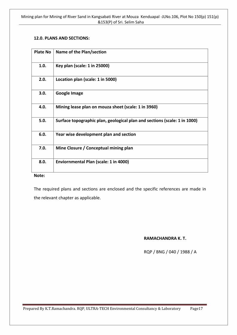
12.0. PLANS AND SECTIONS:
Plate No Name of the Plan/section
1.0. Key plan (scale: 1 in 25000)
2.0. Location plan (scale: 1 in 5000)
3.0. Google Image
4.0. Mining lease plan on mouza sheet (scale: 1 in 3960)
5.0. Surface topographic plan, geological plan and sections (scale: 1 in 1000)
6.0. Year wise development plan and section
7.0. Mine Closure / Conceptual mining plan
8.0. Enviornmental Plan (scale: 1 in 4000)
Note:
The required plans and sections are enclosed and the specific references are made in
the relevant chapter as applicable.
RAMACHANDRA K. T.
RQP / BNG / 040 / 1988 / A


![117] MiningPlan€¦ · CERTIFICATE • I,BirasTirkeyhereby certify that-1.Provisions ofMines Act. Rules and Regulations made there under have been observed inthe aforesaid Mining](https://static.documents.pub/doc/80x56/601ae3ac6458f2253c7d08e6/117-certificate-a-ibirastirkeyhereby-certify-that-1provisions-ofmines-act.jpg)


