37
MINISTRY OF ENVIRONMENT GUIDANCE DOCUMENTS & PROTOCOLS Presentation to Pacific Business & Law Institute May 5, 2016 Peggy Evans Manager, Risk Assessment Land Remediation
| Date post: | 20-Mar-2018 |
| Category: |
Documents |
| Upload: | nguyenthuan |
| View: | 225 times |
| Download: | 2 times |

MINISTRY OF ENVIRONMENT GUIDANCE DOCUMENTS & PROTOCOLS
Presentation to Pacific Business & Law Institute May 5, 2016
Peggy Evans Manager, Risk Assessment Land Remediation

OUTLINE
Recent Documents Pending Documents Groundwater Protection Determining Water Use for Investigation Groundwater Mapping Groundwater Remediation Requirements for Affected Properties Communication Delineation/Remediation of Entire Extent of Contamination
2

RECENT DOCUMENTS
3

PENDING DOCUMENTS – 2016/17
Updates Triggered By Omnibus Protocols 2, 4, 11, 13, Tech Guides 3,7, etc.
Other Documents Draft Technical Guidance 22: Use of Monitored Natural Attenuation
for Groundwater Remediation (date) Draft Protocol 5: Groundwater Remediation Requirements for
Protecting Drinking, Irrigation and Livestock Water Uses Draft Administrative Guidance 15: Approvals Not to Delineate or
Remediate the Entire Extent of Contamination Draft Technical Guidance 4: Vapour Investigation and Remediation Draft Protocol 22: Determining the Presence and Extent of Vapour
Contamination
4

Factors considered in determining water use (CSR 12(2) & (5)): Current and reasonable potential future use Protection for use at a site and on neighbouring lands Prevention of pollution Policies of government or municipality
Protocol 21 provides criteria for determining water uses and water standards for assessing contamination at sites
Water Uses (CSR 12(4)):
Aquatic life (AW)
Irrigation (IW)
Drinking water (DW)
Livestock (LW)
PROTOCOL 21 – WATER USE DETERMINATION
No Use
5

PROTOCOL 21 – WATER USE DETERMINATION
July 2010 December 2015 6

TG6 P21 Shallow aquifers – greater relief Saturated thickness < 2m Composed of fill
Irrigation & Livestock water based on current use only
Bedrock water Mapped aquifers –> DW Yield data required Use of bedrock data within 500 m
Natural confining units – expanded scope equivalent thickness allowed free of contamination (soil only if soil standards)
Filled marine & estuarine foreshore –> no DW
TECH GUIDE 6 TO PROTOCOL 21 – CHANGES
Natural Confining Unit
<2 m
Fill
Drinking water aquifer
>5 m
NO DW
DW
DW
7

8
Future DW use exemption of all geological units located within and below filled former marine/estuarine foreshore
PROTOCOL 21 – HISTORIC SHORELINE, VANCOUVER
8

Director’s Determinations
No relief from specific water uses determined under P21 based on site-specific data but water use(s)
is unlikely or unreasonable to anticipate
Data and arguments presented
in application for Director’s determination of water use
(Appendix 1)
Determinations under Protocol 21
Relief from specific water uses determined under P21 based
on site-specific data
Data and arguments presented in DSI in CS instrument
application
PROTOCOL 21 – DIRECTOR`S DETERMINATIONS
9

GROUNDWATER MAPPING
Groundwater mapping to support determinations of water use Geospatial data to augment site-specific determinations:
Presence of drinking water aquifers Presence of natural confining barriers
Consistent application of water standards Reduced time & cost of environmental investigations
Available Mapping WELLS database and aquifer mapping on iMapBC
Borehole lithology mapping on iMapBC (Lower Mainland)
CSAP Contaminated Sites Legal Instrument Mapping
10

GROUNDWATER MAPPING – MOE WELLS DATABASE
Wells & Aquifer Mapping – iMapBC
11
Vancouver
N. Delta & Surrey
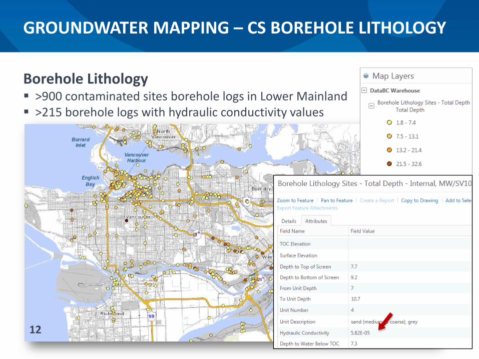
Borehole Lithology >900 contaminated sites borehole logs in Lower Mainland >215 borehole logs with hydraulic conductivity values
GROUNDWATER MAPPING – CS BOREHOLE LITHOLOGY
12

GROUNDWATER MAPPING – CSAP
CSAP Contaminated Sites Legal Instrument Mapping Map of drinking water use from MoE Legal Instruments
DW apply No DW apply DW unknown
13

Selection of remediation options (EMA 56(1)): Remediation must give preference to alternatives that provide permanent solutions to the maximum extent practicable, taking into account factors such as:
a) Risks to human health or the environment; b) Technical feasibility and risks of remediation; c) Remediation costs and potential economic benefits, costs & effects; d) other prescribed factors.
Groundwater Sustainability Living Water Smart (2008) Water Sustainability Act (2014)
Water Objectives
DRAFT PROTOCOL 5 – GROUNDWATER REMED’N REQUIREMENTS
Draft Protocol 5 provides requirements for remediating groundwater at sites where drinking, irrigation or livestock
water uses apply
14
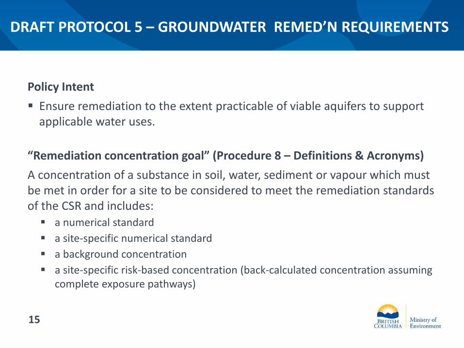
Policy Intent Ensure remediation to the extent practicable of viable aquifers to support
applicable water uses.
“Remediation concentration goal” (Procedure 8 – Definitions & Acronyms) A concentration of a substance in soil, water, sediment or vapour which must be met in order for a site to be considered to meet the remediation standards of the CSR and includes: a numerical standard a site-specific numerical standard a background concentration a site-specific risk-based concentration (back-calculated concentration assuming
complete exposure pathways)
DRAFT PROTOCOL 5 – GROUNDWATER REMED’N REQUIREMENTS
15

DRAFT PROTOCOL 5 - SCHEME
Contaminated Groundwater
Administrative Controls
Usable Groundwater
16

Short-term Remediation Strategy Remediate contamination source and plume to meet the remediation concentration
goals for the entire site within 5 years of issuance of an AIP or COC or as quickly as practicable thereafter
Long-term Remediation Strategies (A & B) Remediate contamination source and plume to meet the remediation concentration
goals for the entire site (A) or for affected properties (B) within 20 years of issuance of an AIP or COC
DRAFT PROTOCOL 5 – REMEDIATION STRATEGIES
17
17

DRAFT PROTOCOL 5 – DIRECTOR’S DECISION
Long-term Remediation Strategy (C) Request approval from a Director to implement an alternative remediation strategy Not feasible to implement remediation strategy A or B Technical &/or cost impracticability is established through a feasibility assessment Remediation of contamination source to maximum extent practicable
Feasibility Assessment Draft Technical Guidance 21 – Feasibility Studies
Limited Use Aquifer Marginal aquifers with no current use & limited potential for future use Petroleum hydrocarbons (<10 X DW stds) with demonstrated degradation Early closure on long term monitoring Permanent closure by institutional controls 18
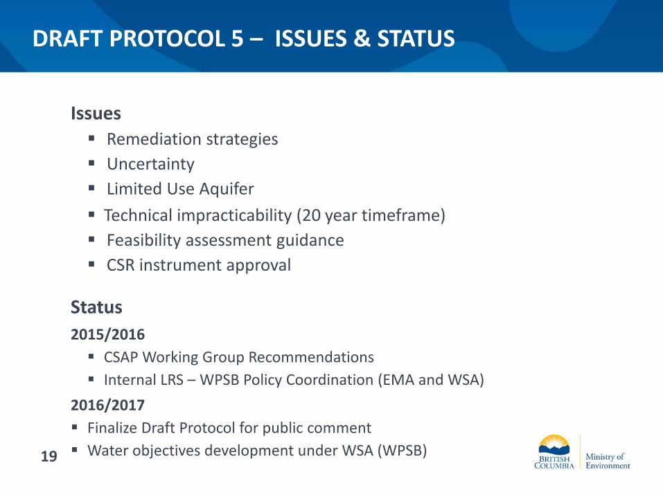
Issues Remediation strategies Uncertainty Limited Use Aquifer Technical impracticability (20 year timeframe) Feasibility assessment guidance CSR instrument approval
Status 2015/2016 CSAP Working Group Recommendations Internal LRS – WPSB Policy Coordination (EMA and WSA)
2016/2017 Finalize Draft Protocol for public comment Water objectives development under WSA (WPSB)
DRAFT PROTOCOL 5 – ISSUES & STATUS
19

DRAFT TECH GUIDE 22: USE OF MONITORED ATTENUATION
“remediation” means action to eliminate, limit, correct, counteract, mitigate or remove any contaminant…..and includes: monitoring, verification and confirmation of whether the remediation
complies with applicable standards and requirements imposed by a director (EMA, (1))
Protocol 5
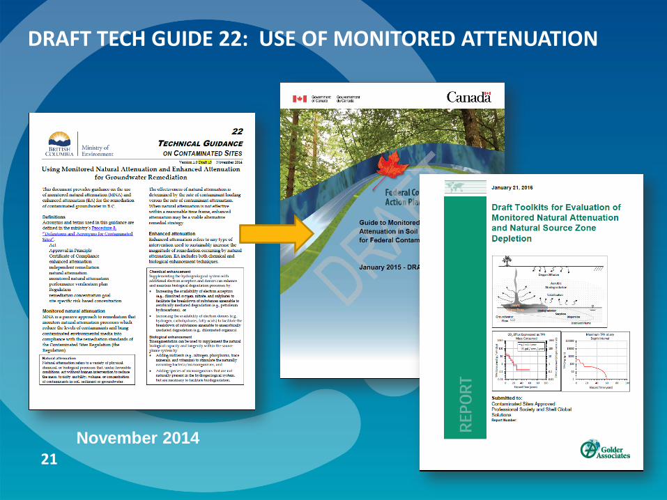
Draft Technical Guidance 22 provides guidance for remediating groundwater using monitored natural attenuation (MNA) and
enhanced attenuation (EA)
20
DRAFT TECH GUIDE 22: USE OF MONITORED ATTENUATION
November 2014 21

TECHNICAL GUIDANCE 22 - DEFINITIONS
Monitored Natural Attenuation MNA refers to natural physical, chemical or biological processes that reduce the mass, toxicity, mobility, volume or concentration of contaminants in soil, sediment or groundwater
Enhanced Attenuation EA refers to processes that increases the magnitude of natural attenuation: Chemical enhancement Biological enhancement
22

TECHNICAL GUIDANCE 22 – SELECTION OF MNA OR EA
MNA or EA used in conjunction with other remediation measures Hydraulic control Groundwater extraction Reactive barriers
MNA or EA used as a follow-up to active remediation measures Source removal/control
Supplemental guidance for MNA/EA TG22 is not prescriptive Incorporate other guidance e.g., EPA, ITRC, Golder Toolkits
From: FAQ about Monitored Natural Attenuation in Groundwater 23

TECHNICAL GUIDANCE 22 – CONDITIONS OF USE
MNA and EA conditions No unacceptable risks to human health or the environment Groundwater contamination sources are remediated or contained Groundwater contamination is shrinking MNA/EA will achieve the remediation concentration goal within 20 years Long term performance monitoring and
validation Contingency plan with implementation
trigger(s) & response Status 2016/2017 Review document along with Protocol 5 Second draft for comment 2017
24

DRAFT ADMIN GUIDE 15 – PREAPPROVALS TO NOT FULLY DELINEATE OR REMEDIATE
Draft Administrative Guidance 15 describes situations where a Director may accept that full delineation or remediation is not
possible or necessary for issuing a legal instrument.
Protocol 6, Version 8.1 (Dec, 2015) 4.5 Subject to section 4.6…any applicant who is a responsible person for
the source of contamination with respect to an application for an AiP or CoC is responsible for the delineation and remediation of the entire area of contamination including contamination at a parcel and that which has migrated from that parcel to neighbouring parcels.
(EMA 1 and CSR 47, 48 & 59)
25

No Types of Applications for Contaminated Sites Legal Instruments Requiring Preapproval
Involving the extent of the area of contamination delineated and remediated
1
If the applicant for a contaminated sites legal instrument is a responsible person for the source parcel and has not delineated and/or remediated the entire area of contamination including contamination at a parcel and contamination which has migrated from that parcel to neighbouring parcels.
Table 2. Applications requiring preapproval by a Director of Waste Management
4.6 Any application for a legal instrument of a type listed in Table 2 must be preapproved by a Director.
DRAFT ADMINISTRATIVE GUIDANCE 15
26

DRAFT ADMINISTRATIVE GUIDANCE 15
General Principles
“Delineation and remediation of the entire area” in Protocol 6 means under a CSR instrument or instruments.
Approved guidance should be followed to the extent practicable, including application of scientifically defensible alternatives.
The Director’s pre-approval process does not replace requirements in protocols (e.g. Protocols 2, 4, 9)
Investigation and remediation to meet regulatory requirements should be conducted to the extent practicable.
Civil matters between parties should be dealt with to the extent practicable between the parties. Preapproval applications involving 3rd parties should include full communication records.
27

DRAFT ADMIN GUIDE 15 – ELIGIBLE APPLICATIONS
Scenario Subject Lands
1 Denied access Affected parcels
2 Technical infeasibility/ Safety hazards
Source parcel/ Affected parcels
3 Merging plumes Affected parcels
4 Flowthrough plumes Affected parcels
5 Area wide contamination Source parcel/ Neighbouring parcels
6 Beneficial Use Source parcel/ Affected parcels
7 Part Site Remediation Source parcel/ Affected parcels
Technica l Expectat ions Only
28

PROTOCOL 6 – PREAPPROVAL DECISIONS
Status 2016/2017 Update based on experience
on approvals to date Finalize in 2017
29

ADMIN GUIDE 11 – COMMUNICATION REQUIREMENTS
May 2013 December 2015 30

COMMUNICATION PROCESS FOR RESPONSIBLE PARTIES
Known or likely migration identified
Send notification of contaminant migration
Seek access for investigations of affected parcels
Investigate/risk assess source & affected parcels
Develop RA/Remediation Plan Seek input/agreement from affected
parcel owners AP review of application &
communication record Submit application with detailed communication record under P6
31
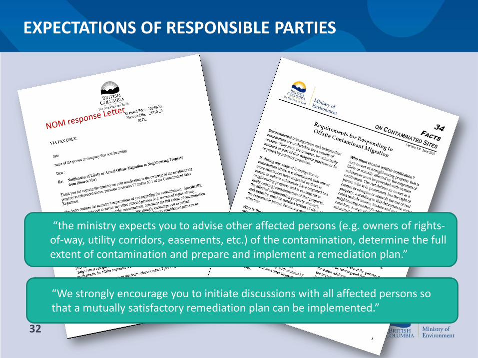
EXPECTATIONS OF RESPONSIBLE PARTIES
“the ministry expects you to advise other affected persons (e.g. owners of rights-of-way, utility corridors, easements, etc.) of the contamination, determine the full extent of contamination and prepare and implement a remediation plan.”
“We strongly encourage you to initiate discussions with all affected persons so that a mutually satisfactory remediation plan can be implemented.”
32

DIRECTOR’S OBLIGATIONS FOR ISSUING INSTRUMENTS
“ensure that…affected parties have an opportunity to review and comment on relevant site investigation information and on any proposed remediation in relation to contamination migrating onto their land.”
“allow adequate time for affected parties to review information and consider any comments received before making any decisions.”
33

WHY COMMUNICATE
To determine for all affected parcels whether:
investigations are adequate; assumptions of current and reasonable future land, water or sediment
uses are valid; assumptions of any risk assessment are valid and appropriate; and any land, water or sediment use restrictions or risk-management
actions required for risk-based remediation of affected parcels are appropriate and achievable.
34

WHAT TO COMMUNICATE
For each affected parcel, responsible parties must provide affected parcel owners with: all relevant site investigation and risk assessment results for the
affected parcel; information on land, water, or sediment use assumptions; a description of any land, water, or sediment use restrictions or risk
management actions required for risk-based remediation; opportunity to comment on any of the above; and a response to all legitimate concerns raised explaining how they will be
addressed.
35

Site Profile Intention Paper – “Identification of Potentially Contaminated Sites”
Contaminated Soil Relocation Agreements Intention Paper – “Prevention of Site Contamination from Soil Relocation”
HWR, CSR amendments – decouple regulations Brownfields Strategy 2 – draft intentions papers Land Remediation Fund – review options (link to spills, brownfields &
residential USTs)
2016/17 INITIATIVES (Other than Omnibus)

2016 Site Remediation in B.C. Conference September 21st -22nd, 2016 Vancouver Convention Centre
siteremediationinbc.com


