MINNESOTA'S MINERAL HERITAGE CONSERVATION BULLETIN NUMBER TWELVE MINNESOTA OF CONSERVATION This document is made available electronically by the Minnesota Legislative Reference Library as part of an ongoing digital archiving project. http://www.leg.state.mn.us/lrl/lrl.asp (Funding for document digitization was provided, in part, by a grant from the Minnesota Historical & Cultural Heritage Program.)
Transcript
MINNESOTA'S
MINERAL
HERITAGE
CONSERVATION BULLETIN NUMBER TWELVE MINNESOTA OF CONSERVATION
This document is made available electronically by the Minnesota Legislative Reference Library as part of an ongoing digital archiving project. http://www.leg.state.mn.us/lrl/lrl.asp (Funding for document digitization was provided, in part, by a grant from the Minnesota Historical & Cultural Heritage Program.)
Author's Foreword Our natural resources constitute the foundations· of our well-being.
the means of our protection, the hope of our future. The resources of any region determine to a marked degree . the activity of its inhabitants. Minnesota, though known as an agricultural state, has great mineral wealth and many of its citizens are engaged in mineral industries. Only ten states exceed Minnesota in the value of their annual mineral output. Of these ten, six are the great oil-producing states, three are the coal-producting states of Pennsylvania, West Virginia and Illinois, and one is California with its oil and gold.
All of the mineral substances produced from the rocks of the states may be considered industrial minerals. Some are metals and others are non-metals. Metal mining· is restricted to the iron ranges, but the non-metals include a great variety of materials, such as limestone, agricultural lime, dolomite, marl, sand and gravel, clays and shales, wool rock, structural and architectural stone, etc., which are excavated and processed at many different places in the state.
In the preparation of the articles in this bulletin, the main objective of the author was to acquaint the citizens of the state with the nature and extent of our mineral heritage. It is hoped that the publication will be instrumental in arousing greater interest in the many undeveloped mineral resources of our state.
In assembling the data in the individual articles, many of the reports and bulletins issued by the Minnesota Geological Survey were used. The author gratefully acknowledges and gladly expresses his obligation to the members of that Survey who made the original investigations. For greater details the reader is referred to the original reports listed in the appendix to this bulletin.
G.A.T.
CONSERVATION BULLETIN NUMBER TWELVE
MINNESOTA'S MINE AL HERITAGE
By GEORGE A. THIEL
Professor, Geology and Mineralogy
Chairman, Department of Geology and Mineralogy
University of Minnesota
MINNESOTA DEPARTMENT OF CONSERVATION Saint Paul, Minnesota
1947
Our stone industry is more than a century old.
Stone for Sturdy Structures Over 50 Kinds Are Quarried in Minnesota
George A. Thiel
Minnesota has natural mineral re- cultures on the basis of the use of sources of great abundance and wide stone and many of the ancient culdiversity of character and of location. tural groups produced work that still These have played a major part in holds the admiration of modern artthe development of our Common- ists. The history of the civilizations of wealth, as they account for a high the past is recorded in their stone percentage of the state's in- .------- buildings. Time has mellow-dustry. The last 50 years Minnesota's ed the color of the rock have been characterized by Mineral minerals, but the rock is still an enormous increase in the Heritage intact. utilization of a 11 mineral • • • The stone industry in Min-products. In fact, during this !Vu~ C11e nesota began more than a period more mineral wealth century ago when limestone has been extracted from the earth was quarried to build part of Fort than during all its previous history. Snelling. From this small beginning
It is apparent that such an accele- in the early history of the territory, ration of production must be accom- the industry has progressed, with pepanied by the adaptation of conserva- riods of fluctuation and retardation, tion practices; for, if our present until today it has become the second economic and social system is to be in value in the mineral production maintained, it follows that a steady of the state. The stone industry now How of mineral products must go to gives employment to hundreds of perour industries. sons, from trained administrators and
BUILDING STONES
Ever since man has dwelt upon the earth's surface, stone has been used in the construction of his dwellings. Even the cavemen had subterranean homes of stone that Nature designed and sculptured out of solid rock. The anthropologists classify early human
4
salesmen to quarrymen and skilled stonecutters and carvers. During the past ten years many new varieties of stone have been located and quarried for commercial purposes and great strides have been made in the methods of quarrying and fabricating stone. Modern machinery has elimi-
STONE FOR STURDY STRUCTURES 5
nated much of the tedious manual labor, and wastage has been greatly reduced by the utilization of various by-products. Today more than fifty distinct varieties of architectural stone are quarried and fabricated in this state. For many years Minnesota stones enjoyed a national reputation for beauty and adaptability before their merits were recognized by our local builders. The inadequate conception that most people have of the importance of the stone industry in Minnesota was evident to the writer from the surprise shown by many persons the first time they saw polished samples of the many beautiful varieties of granites, limestones, dolomites, and sandstones that are taken from local quarries.
The essential qualities of building stones are strength, durability, workability, color, and beauty. The properties required for diHerent uses vary greatly, depending upon the type of structure for which the stone is to be employed. For bridge spans great strength is essential; for monuments and other outdoor structures, appearance and resistance to weathering are required; and for interior decoration, pleasing color and adaptability to carving, and polishing are the most important properties.
The three main classes of rocks from which our stone products are derived are igneous, sedimentary and metamorphic. IGNEOUS ROCKS are formed by the solidification of molten
· mineral matter. When this process takes place in large masses far below the surface of the earth, the masses are called batholiths. Some batholiths are scores or even hundreds of miles across, extending downward to great but unknown depths. Because of their great size they cool and crystallize slowly and are therefore relatively coarse-grained like the common granites. The natural processes of disintegration and transportation, acting through geologic ages, have carried away the rock formations that were formerly over the batholiths and today our granite quarries, such as those in the St. Cloud region, are in the exposed granite masses.
Some molten matter may reach the surface and flow out as lava. When lavas are exposed to the air they cool rapidly and are so fine-grained that the minerals in them cannot be recognized. A dark-colored lava rock, commonly called traprock, is very abundant at Taylors Falls and along the north shore of Lake Superior. It is quarried and crushed for use as concrete aggregate, road material, and so forth.
The granites that are being utilized commercially are found in three widely separated regions in Minnesota: ( I ) central Minnesota, particularly in the region of the city of St. Cloud; ( 2) the upper Minnesota river valley from New Ulm to Ortonville; and (3) the Arrowhead region, which includes
6 MINNESOTA DEPARTMENT OF CONSERVATION
the area north of Duluth in Sf. Louis, Cook and Lake counties.
The stone of the St. Cloud region may be grouped into three major types, namely, pink granite, red granite, and gray granite. The difference in color is due mainly to the character of the feldspar minerals in the rock. These may be colorless, pink, deep red or gray. The pink granites are quarried southwest of St. Cloud. They are best described as a stone with large pink crystals set in a finergrained black and white matrix. The finished stone is marketed under such trade names as Rockville Pink, Cold Spring Pearl Pink, Original Minnesota Pink, and Sauk Rapids Pink granites.
The red granites owe their color to llie orthoclase feldspar which is deep red and ·constitutes about 75 per cent of the rock. The granite is marketed under a variety of trade names, such as Indian Red, Rose Red, Melrose Red, Ruby Red, Mahogany Red, etc. Much of the rock is used for monumental purposes, but some architectural stone is also fabricated.
The gray granites owe their color to gray feldspars and associated black minerals such as hornblende and mica. Various shades of gray occur, depending upon the ratio of feldspars to black minerals. The gray granites south of Mille Lacs Lake, in the region of Isle and Warmen Creek are rather light gray due to the presence of nearly colorless feldspars with black hornblende.
Most of the granites in the Minnesota valley are characterized by attractive color tones in peculiar wavy veins and swirling figures. Because of these textural patterns, the granite has been given a variety of trade names, such as Rainbow, Tapestry, Oriental, Variegated, etc. Its variations in color and texture make it especially desirable for facings, columns, and certain types of interior work. Huge polished slabs may be seen as facing on many large office buildings, such as the Telephone Building and the Baker Building in Minneapolis, the Daily News Building in Chicago, the City Service Building in New York City, the San Juanto Building in Houston, Texas, and many other equally prominent structures.
Black and green rocks that are petrographically known as gabbros and diorites are quarried in the Arrowhead region and sold under such trade names as Emerald Tone, and Arrowhead Black Granite.
SEDIMENTARY ROCKS represent the accumulated sediments carried by the rivers to basins of sedimentation where the river waters come to rest. In this way vast layers of sediment accumulated on the floors of primordial seas. Slowly the loose debris was cemented together with lime, silica and other minerals which were carried in solution by the water that filtered through it. The early sediments were buried deeper
STONE FOR STURDY STRUCTURES 7
and deeper by succeeding deposits, until eventually they were compacted and cemented in layers of solid rock. All sandstones, limestones, dolomites, and shales have been formed by such processes. Today such rocks are exposed at the surface where they are quarried and used extensively as structural and architectural stone. The numerous marine fossils in the strata give evidence of their origin on the floor of the sea.
In some localities, limestone quarries were opened to obtain stone for certain specific structures, on the completion of which the quarries were abandoned. Along the Mississippi River Valley rip-rap is quarried extensively for engineering projects in the valley, and in the driftless and loess-covered areas, where gravel is scarce, much limestone is quarried and crushed for highway construction work. In several localities, limestone is burned for the manufacture of lime, and some dolomite is quarried for cement.
Prior to the war there was a steady demand for Minnesota limestone for architectural purposes, and with the growing desire for attractive, permanent and dignified stone buildings, the limestone and marble industry should flourish again after the war. Architects are becoming more and more interested in variegated wall surfaces, and are building up a demand for
limestone that varies both in color and in texture. Several ledges or strata of different color are found in the Mankato-Kasota district, and when used at random, these blend beautifully and give individuality to the structures. Most of the stone is a fine-grained dolomitic limestone, yellow and yellowish pink in color. Certain ledges of the yellowish stone have solution cavities that give it a texture similar to that of travertine. When sawed across the bedding planes, it is called Veine and when cut parallel to the beds its design is called Fleuri. The yellow stone is used for decorative details because of its rich color, with markings a trifle darker in shade.· Such shadings are also characteristic of some of the pink varieties. The selection of Minnesota dolomite for the exterior of the Art Museum Building in Philadelphia demonstrates the widespread appreciation of our architectural stones for exceptionally fine buildings.
(EmToR's NOTE: Those interested in further reading on this subject are referred to The Architectural, Structural, and Monumental Stones of Minnesota by George A. Thiel and Carl E. Dutton. It is Bulletin 25 of the Minnesota Geological Survey and was published by the University of Minnesota Press in 1935.)
Each year 26,600 cubic miles of water fall on the earth's surface.
Is There rWatei; Watei; Everywhere? The Hydrologic Cycle - An Eternal Merry-g0-round
George A. Thiel
iLife would be scarcely worth living,-if, indeed, it could be maintained,- without an ade
quate supply of pure water. That is the reason villages and cities have spent uncounted billions of dollars, in
B. Water vapor condenses to form rain or snow, which falls to the surface of the earth but then evaporates before infiltration takes place. Thus the water returns to the atmosphere before becomiNg underground water.
the aggregate, to establish the water supply systems which yield safe and pure water every time you open a faucet in your home. This water may have been deep
Minnesota's Mineral Heritage
within the earth, in lakes or ·-------JI
C. Water vapor condenses and falls to the ground as rain or snow. The water seeps below the surface where (I) it may be held temporarily as soil moisture and then be returned by
streams many miles away. But, you may ask, where does it all come from?
The answer to the above question is really very simple. Nature actually practices conservation. She uses the same water over and over again, even though the forms in which it occurs may vary exceedingly. Most of the water we use today has been circulating since the world began. This eternal merry-go-round is called the hydrologic cycle. The processes involved may be summarized as follows:
A. Water vapor condenses to form rain, snow, or fog, which may evaporate again before reaching the earth's surface.
8
plant transpiration and evaporation, or ( 2) may percolate downward toward the zone of saturation.
Some of the water from the rain or snow that percolates beneath the surface is stored only temporarily as perched ground water, or flows through the pores of the loose mantle rock quickly enough to augment floods or to maintain high-water stages of the streams immediately after the floods. Much of the water, however, sinks to the main water table as free:..moving water and is discharged as effiuent seepage and spring flow. This flow furnishes the water of the streams during dry or frozen seasons. A smaller percentage
IS THERE 'WATER, WATER, EVERYWHERE'? 9
Ra/n, Jnow, !toil, etc.
z 0
~ a 0 Q.
&oport1fion while follinJ or from surfaces <( > w
T1Y1nspir1Jtion from soil throu/h f'lonb
THE HYDROLOGIC CYCLE. It has been estimated that a drop of water evaporated
from the ocean rains five times before it gets back to the sea. (After National Resources
Board Report.)
may move as confined water in and through ground-water conduits. It may percolate through such artesian aquifers for hundreds or thousands of years before it is returned to the surface or discharged on the floor of the sea.. Some water apparently remains entrapped in deep-seated rock formations for large units of geologic time.
INFILTRATION OF GROUND WATER
Infiltration is the movement of water from the surface of the earth into the soil and rocks of the earth's crust. The amount of meteoric water that penetrates the earth is determined by several factors, chief of which are ( 1) the amount and kind of precipitation, ( 2) the rate of precipitation, ( 3) the slope of surface, ( 4)
10 MINNESOTA DEPARTMENT OF CONSERVATION
the porosity of soil and rock, ( 5) the structure of the rock formation, ( 6) the amount and kind of vegetation on the surface, and ( 7) the amount of moisture in the atmosphere. Within certain limitations the amount of water that soaks into the ground is determined by the amount of precipitation as rain. In desert areas, ground water generally lies deep, and little water occurs near the surface. The more rapid the rainfall, the less the amount of water that sinks into the earth, for the surface soon becomes saturated. The same is true of the melting snow. The more rapid the rate of melting, the less the amount of water that sinks into the ground, especially into frozen ground. The steeper the slope of the ground, the greater the percentage of the run-off. The flatter the ground, the greater the amount of water that will sink below the surface, because the runoff is retarded, and the water has a longer time to soak into the ground.
Weathered and stratified rocks are more favorable for the entrance of water than most igneous rocks. Inclined strata will allow more water to penetrate than flat-lying beds. Water passing down inclined beds will follow the most porous layers. If the rocks are horizontal, the water passing downward must cross also the less porous beds. Plants and organic material derived from plants check the flow of surface water, causing the flow of water to sink below the
surface. Forests and meadows hold back the run-off and also retard evaporation. If the humidity is low immediately after a shower, much of the rain evaporates before it can sink into the earth. This is especially true in arid regions, where even after heavy rains most of the water evaporates and passes again into the atmosphere.
For a given drainage basin the approximate rate of infiltration can be determined if stream-gauging stations have been installed, and if there are adequate records of both the amount and the intensity of rainfall on the various geographic units of the basin. The type of land usage in each unit of the drainage basin must also be considered. Virgin soil possesses the structural characteristics that are most favorable in promoting infiltration. Native grasslands, forests, and areas of rotated crop land allow a more rapid infiltration than intensively cultivated lands that are low in organic content. It has been shown that cultivation destroys natural structural aggregates and thus causes soil particles to gradually assume a position of closer packing.
WHAT DETERMINES THE YmLD OF
GROUND WATER
If a high percentage of the rain that falls on the earth percolates into the rocks, there should be "water, water, everywhere," below the surface. If so, why isn't it possible to dig or drill a well anywhere in Min-
IS THERE 'WATER, WATER, EVERYWHERE'? 11
nesota and obtain an ample supply of water? The answer to this question is found in the variation in the porosity and permeability of different kinds of rocks and subsoils. Some rocks are very permeable. That is, the pore spaces are sufficiently large that water can flow through them freely.
Well-sorted deposits of uncemented gravel, sand, or silt have a high porosity, regardless of whether they consist of small or large grades. However, if the material is poorly sorted, small particles occupy the spaces between the larger ones, still smaller ones occupy the spaces between these small particles, and so on, with the result that porosity is greatly reduced. Boulder clay, which is an unsorted mixture of glacial drift contain:iing particles of a great variety of materials of varying sizes, may have a very low porosity, whereas outwash gravel and sand derived from the same source but sorted by running water may be highly porous. Well-sorted and uncemented gravel may be composed of pebbles that are themselves porous, so that the deposit as a whole has a very high porosity. Well-sorted porous gravel, sand, or silt may gradually have its interstices filled with mineral matter deposited out of solution from percolating water.
From the standpoint of the yield of ground water, Minnesota may be divided into three major areas, each with its own water supply problems.
From St. Cloud northward to the Canadian boundary and westward to the Red River valley, the glacial drift rests on very ancient crystalline rocks that have a porosity of less than 2 percent. Over that entire area, the only reliable source of ground water is the unconsolidated glacial drift. In many communities these glacial deposits are composed of unsorted boulder clays that are quite impervious, and even if they are saturated with water, the flow is so slow that the yield of a well is small. In areas where layers of sand and gravel are interbedde·d with the clay, ample supplies of water are produced from the coarser sand and gravel strata.
Most of the southwestern part of the state, from Swift and Kandiyohi counties southward to the Iowa-Minnesota line, is underlaid by a series of marine sandstones and shales that occur under the glacial drift, and they rest in turn on the granites and other crystalline rocks such as are exposed in the Minnesota Valley near Granite Falls, Morton, and Montevideo. These marine sandstones yield water copiously but much of the water contains such high percentages of dissolved mineral salts that it is unfit for domestic and industrial use. Here again, the purest water occurs in the glacial drift.
The southeastern counties, from Wright county southward to Mankato, and eastward to the Mississippi River are over an area where the
12 MINNESOTA DEPARTMENT OF CONSERVATION
rocks below the glacial drift contain layers of porous, marine sandstones such as those exposed in the walls of the valleys of the Mississippi and St. Croix rivers. These sandstone strata have a porosity of from 20 to 35 percent and, where saturated with ground water, wells that penetrate them yield from 500 to 1000 gallons per minute. Structurally, these rocks form a broad, trough-like structure, one margin of which crops out along the Mississippi Valley, and the other occurs under the glacial drift in the counties to the north and south of Mankato. The Twin Cities area is a local, saucer-shaped basin at the north end of the larger trough-like structure. Because of these structural relations, southeastern Minnesota is endowed with an exceptionally large supply of artesian water.
In order to more fully appreciate the variation in the distribution of water in the land areas of the earth, a few words regarding the role of the atmosphere in transporting water from the ocean to the land may not be amiss.
The earth's atmosphere constitutes slightly less than a millionth part of the earth's whole mass. But the rain which falls from the atmosphere every century weighs seven times as much as the air itself. Three-fourths of this rain falls back into the ocean. Even so, the work of the atmosphere amounts to pouring all the water of the oceans over the land once in
twelve thousand years. Nearly threefourths of this rainfall again vaporizes. What remains flows back to the sea in rivers. An amount of water equivalent to the whole volume of the ocean has done this at least thirty thousand times during the known duration of geologic history.
The total annual fall of meteoric water on the earth's land areas is about 26,600 cubic miles. This precipitation varies greatly both with respect to geographic location and time. Furthermore, it may be in the form of rain or snow. In polar regions the snowfall represents from eight to fifteen inches of water, whereas, oncertain slopes of the Himalayas, the rainfall may be. as much as five hundred inches a year. In dry regions, such as the vast desert areas of northern Africa, central Asia, Australia, and along the coast of Peru, only a few inches of water are precipitated annually. Among the Canary Islands, surrounded by water, are localities that have very little rainfall for periods as long as three years in duration. Such great variations in rainfall raise important problems in agriculture, forestry, and water supply engineering. But regardless of where the raindrops may fall, they inevitably return to the clouds to start the cycle all over again, "to be renewed in eternal resurrection," as Emil Ludwig thus beautifully describes the hydrologic cycle in his book on the Nile.
IS THERE 'WATER, WATER, EVERYWHERE'?
~PALEOZOIC ~CRETACEOUS
~ PRE-CAMBRIAN
13
GENERALIZED MAP OF MINNESOTA, showing the major areas of pre-Cambrian,
Paleozoic, and Cretaceous rocks. Each area is a separate ground-water province. In the pre
Cambrian area water must be obtained from the glacial drift. The Paleozoic rocks are in
clined and contain porous aquifers. The Cretaceous rocks are mainly horizontal shale beds,
with some sandstone members. (This map and the sketch on page 11 are reproduced from
the Geology and Underground Waters of Southern Minnesota by George A. Thiel, through
courtesy of the University of Minnesota Press.)
Nearly every county of the state has some commercial clay.
The Potters Clay One of Earth's Commonest Materials
George A. Thiel
Ordinary clayey soils are among the commonest materials at the surface of the earth. There are two definitions of clay in common use; the first is that used by the ceramists or clay technologists, and the second is the geologists' definition.
Deposits of clay are of two general types, residual and transported; but in all cases the clay is of secondary origin, that is, it was formed by the alteration of some other rock. The residual deposits were formed by the
alterations or decomposition The ceramist defines a clay as a natural-occurring mineral substance which is
Minnesota's
Mineral
more or less plastic when Heritage
of a rock in place. This alteration may be of two types, one involving chemical change resulting in the formation of clay, the other involving simple solution
wet, and which when heat- ;1;umk/j, 7/uee ed to redness or above, be-comes permanently hard. The geologist, on the other hand, defines clay as a mixture of minerals composed essentially of hydrous aluminum silicates (predominantly K a o 1 n i t e, H4A12Si20 9 in particles which range in size from approximately 0.005 millimeters to submicroscopic.
Clays are seldom pure. They commonly contain various amounts of such minerals as quartz, calcite and feldspars in a fine state of division or as grains the size of silt and sand. Mort clay is so soft that you can dig it with a spade or cut it with a knife. Its colors range from white to green, brown or brick-red. Hard and indurated clays are called shale.
14
of a rock containing clayey impurities and the consequent deposition of the insoluble clay. Residual deposits of the first type are usually formed by the chemical alteration of granites and other rocks which con-
-tain a high percentage of feldspar. The alteration of pure feldspars result in pure kaolins, whereas the alteration of granites results in mixtures of kaolin, silica and mica, together with other impurities originally in the granite. Thick deposits of such white kaolintic mixtures may be seen in the roadcuts in the region of Morton, Redwood Falls and Ft. Ridgely. In humid tropical or subtropical regions the residual clays are
THE POTTER'S CLAY 15
red, brown or yellow because the iron compounds in them are oxidized and often combined with water to form the red and yellow oxides of iron such as hematite and limonite.
Deposits of sedimentary or transported clay5 may have settled on the flood plains of valleys when shallow rivers overflowed. Other were transported and settled to the floors of lakes and swamps that are now drained and still other deposits settled to the floor of the inland seas that occupied this area at intervals during the distant geologic past. Such marine clays and shales contain many petrified corals, bryozoa and other sea-dwelling animals. Marine fossils are abundantly present in the shale pit of the Twin City Brick Company plant in St. Paul.
Many of the transported clay deposits in Minnesota are of glacial origin and were deposited as glacial lake clays, river clays or till plain clays.
CLASSIFICATION OF CLAYS
BY USES
Clays have been classified upon many different bases and in many different ways. Thus, they may be classified according to their mode of origin as outlined above, or according to their chemical or physical properties, their uses, or combinations of any or all of these methods. From a commercial standpoint, probably the classification by properties and uses is most important. How-
ever, it should be noted that no classification is perfect, for one clay may be adapted to several widely differing uses.
High-grade clays include whiteware clays, pottery clays, refractory clays and medicinal clays. The whiteware clays may be plastic or nonplastic and they are composed chiefly of white kaolin. They are used in the manufacture of porcelain, china, pottery and high-grade tile. Non-ceramic uses include such things as "filler" for paper, cloth and window shades, as coating for wallpaper and in the manufacture of rubber, oilcloth, soaps and toilet and tooth powders. It is used also as an invert extender of paints and white washes and as an adulterant in candy, food products, medicinal powders and other products.
Refractory or fire clays are clays which endure high temperatures without change other than dehydration. Their principal uses are in making fire brick and other heat resisting materials required in the iron and steel industry and in making coke. Refractory clays must be relatively free from minerals that act as fluxes, such as calcite, dolomite, iron carbonate, and excessive silica. Flint clay is a non-plastic, hard, dense refractory clay, having an appearance much like flint.
Pottery clay is a general term that includes some refractory and some vitrifying clays. They have high plas-
~-":"'---L..._ _ _L__--1. _ _'.:__J_____!;:!._J_ __ .L.Ji~ZLL-1-6:l'.-' w ... ..="°.:....:.-. ~· :...:JU'iTh Loess I I
·.·\'
I
.. , D .. .. <> :.-0.1 0
91$ 9.¢ 92 ..?O
THE POTTER'S CLAY 17
ticity, great tensile strength, and complete retention of form while being burned. They are, as a rule, semirefractory and burn to a dense, rigid mass. The common products mamifactured from such clays are earthen and stoneware-both plain and decorated, crockery and glazed ware, various color combinations may be produced by changing the content of iron and maganese.
Low-grade clays. As the name implies, these clays are composed of less well-sorted materials and many are of the vitrifying type. That is, they fuse to a glassy vitreous mass or take on a glassy glaze when burned. Many low-grade clays contain considerable iron which acts as a flux and gives color to the glaze. The good clays of this type have a wide range in temperature between incipient and complete fusion. They are used to make terra-cotta ware, roofing tile, hollow drain tile and glazed water pipes, and paving bricks. Almost any kind of clay which possesses plasticity can be used for common brick. Red-burning clays are preferred as they harden at a low temperature.
Adsorbent clays. The use of certain clays as bleaching or decolorizing agents was known to the ancients. The Chinese have used "soap" clays in removing oil and grease from wool and textiles for thousands of years. Today about 90 per cent of the adsorbent clay is used for de-
colorizing and stabilizing petroleum lubricants. The remaining 10 per cent is used chiefly. in the fat and vegetable-oil industry.
The decolorizing action of adsorbent clays on oils is not a filtering or straining action, but a selective adsorption, such as occurs in dyeing fabrics. The dye leaves the solution and adheres to the textile fibers and will not wash off. In a similar manner, the darker constituents of oil are adsorbed on the clay, leaving behind the colorless constituents. The result is a clear, nearly colorless vegetable or mineral oil.
Adsorbent clays are used too for renovating dry-cleaning fluids such as naphtha, gasoline and chlorinated hydrocarbons. If the proper amount of clay is added to a batch of clothes being cleaned, the cleaning fluid remains water-white at all times and acts merely as a solvent and carrier between fabric and clay.
MINNESOTA'S COMMERCIAL CLAYS
Clays in Minnesota were used for the manufacture of brick as early as 1862, and by 1884 it was being used to make pottery, drain tile and fire brick. Nearly every county in the state has some clay that may be used commercially. Clays of marine origin occur in two geologic formationsthe Decorah shale of Ordovician age and the Benton shale of Cretaceous age. The Decorah shale extends from the Twin Cities south and southeast and the Benton shales
18 ~MINNESOTA DEPARTMENT OF CONSERVATION
are found at widely scattered points from Brown county to Goodhue county. It is being used on a large scale at Springfield in Brown county.
The residual clays in Minnesota have resulted from the weathering of pre-Cambrian granites. They occur beneath the glacial drift over large areas in southwestern and westcentral Minnesota. They crop out along the Minnesota valley in Ramsey State Park north of Redwood Falls and near Richmond in Stearns county. Well records indicate that, at many places, white kaolinitic clays attain a thickness of 50 to 100 feet.
Glacial lake clays occur in the area southwest of Duluth, in what was the bed of glacial Lake Duluth. There are large deposits of red plastic clay that were reassorted by stream and wave action and are now excellent brick and pottery clay. It has been mined extensively in the region of Wrenshall.
River valley clays occur along the wide valleys of the Mississippi and Minnesota rivers and their major tributaries. These are banded, gray, glacial clays laid down thousands of years ago when these streams carried sediment-laden water from the melting ice sheet. Clays of this origin have been used at Chaska and J ordan along the Mississippi river from Minneapolis to Brainerd. The old pits at Coon Creek, north of Minneapolis,
produced many tons of high-grade brick and tile clay.
Wind - deposited material known as loess, and composed of fine silt and clay, mantles most of the surface in an area in the southeastern part of the state embracing much of Goodhue, Olmsted, Wabasha, Winona, Fillmore and Houston counties, and parts of Mower, Dodge, Rice and Dakota counties. On the upland plateaus of these counties it attains a thickness of 25 feet. This loess was deposited originally as fine glacial outwash, but later it was transported by the wind and redistributed over the surface of the drift. The more clayey varieties of the loess can be used in the manufacture of brick.
The city of Red Wing has long been famous for its . ceramic industries. At the present time they utilize about 50,000 tons of clay annually. They now manufacture much ornamental pottery, including such articles as jars, jugs, flowerpots, mixing bowls, casseroles and other household accessories.
Minnesota's clay resources have been prospected by the Minnesota Geological Survey in sufficient detail to assure a supply for many decades. Geological indications in the areas now being mined are most encouraging, and it is very likely that future prospecting will disclose additional reserves.
Iron occurs in nearly all classes of rocks and mineral deposits.
Iron Ores-Our Minerals of Might They Fired the Arsenal of Democracy
George- A. Thiel
Iron is the fourth most abundant the formation of sedimentary iron deelement in the earth's crust, and it posits have occurred at many times is nature's most common pigment. in the remote past. These conditions The red, pink, orange, brown and were often very similar in widely green colors in rocks and soils are separated areas. So similar are the caused mainly by iron compounds. pre-Cambrian iron formations of Comparatively small amounts ~------ Minnesota, Wyoming, Lab-o£ these compounds produce Minnesota's rador, Brazil and India that conspicuous colors. The bril- Mineral geologists are scarcely able liantly colored sandstones of Heritage to find diagnostic mineralo-the Painted Desert, or the • • • gic differences. "Red-beds" of the Spearfish !Vumk4 qcm/l, The iron formations on region of South Dakota, contain no more than 5 to 10 per cent of iron.
Iron occurs in nearly all classes of rocks and mineral deposits, but its ores are concentrated in small and widely scattered areas. By far the most important single class is sedimentary iron ore but many large deposits belong to the groups known as magmatic segregation and contact metamorphic ores. Of the many iron minerals known, only the oxides, hematite (Fe203 ), magnetite (Fe30 4 ),
and limonite (a mixture of hydrated iron oxides), the carbonate siderite (Fe C03 ), and the ferrous silicate chamosite are important in ores.
Geological condition~ favorable to
the three ranges in Minnesota (see map) slope or dig toward the basin of Lake Superior, and those of northern Michigan and Wisconsin dip north or northwest. Most of the central part of the Superior basin is occupied by basic lava flows, commonly called trap-rack, and by the great intrusive masses of "black granite" or gabbro that may be seen in the hill at Duluth. The character of the sedimentary rocks and the succession of the different lithologic types are very similar on the two sides of the Lake Superior basin.
The accompanying map shows the geographic location of the iron-bearing rock formations and of the more important magnqtic lines ill Minne-
19
20 MINNESOTA DEPARTMENT OF CONSERVATION
sota. These rocks were originally formed from gelatinous accumulations of marine precipitates of silica (Si02 ) and iron compounds. This material later hardened into darkgray bedded strata that became as hard as flint and contained no more than 20 to 30 per cent of iron. Where these rocks are still unaltered they are called taconite or ferruginous chert. The banded jaspery chert of the Soudan iron formation on the Vermilion range is called jaspilite. Where much of the iron has been oxidized they are known as oxidized taconite, and where a high percentage of the iron has been recrystalized to magnetic iron, they are called magnetite taconite or magnetic taconites. Only in restricted zones where the silica has been leached out by waters circulating through .cracks and fissures has the taconite been converted into commercial ore.
If the Biwabik iron formation. were exposed to view by removal of the glacial drift and the cretaceous sediments (See figure 2) from the region of Grand Rapids to Babbit, not more than 10 per cent of the area of the formation would be found to contain enriched ore. The remaining 90 per cent or more would be some form of taconite.
Most of the ore bodies on the Mesabi Range have one of three shapes-trough, fissure, or flat lying. The trough-shaped deposits range in size from widened fissures to some
that are several miles long, 1,000 feet wide and from 200 to 400 feet in depth; the trough-like shape of the ore body is due to the natural slump that takes place in the ore as the silica is removed from the taconite. An original thickness of 100 feet of taconite forms about 65 feet of concentrated ore. Fissure ore bodies are much smaller than troughs and may be only 2 or 3 feet wide, with a depth of as much as 100 feet and a length that may be 200 feet. Flatlying ore bodies may look like troughs whose upper portions have been eroded, or they may be layers of ore which follow some particular flat-lying horizon of the iron-bearing formation.
The Soudan iron-formation of the Vermilion range (see map) is not a single large extensive iron-bearing bed like that of the Mesabi Range, but consists of lenses of relatively small dimensions. These were folded very complexly during the mountainbuilding epochs that preceded the deposition of the Biwabik iron formation. The conspicuously banded character of the Soudan formation makes it easy to observe the folding, which, in most localities of outcrop, is very intense. The ore bodies at Tower and Ely are as irregular in outline as the formation itself. The ores are mostly hard and dense bluish, crystalline hematite that is an exceptionally fine material for the blast furnace.
9Pre·(om6'-ion f;:::,of,on [bill L ovrenhoa qrofJ!le
qreen·
~ILtS
Fig. 1. (map) Geologic map showing locations of iron-bearing formations. (From Mineral Resources of Minnesota, published by Univ. of Minnesota Press.)
21
22 MINNESOTA DEPARTMENT OF CONSERVATION
bearing rocks in seven or eight main belts, some being less than a mile long, and others extending almost continuously for many miles. The most productive part of the range is in Crow Wing county. Here the ore bodies are roughly tabular in shape, the longer axes being parallel to the bedding of the enclosing rocks. Their widths range up to several hundred feet and their lengths to possibly a mile. Some are shallow; others are as much as 700 feet deep.
The average iron content of Mesabi Range taconite is given in the accompanying table which represents a compilation made by E. W. Davis, Director of the Mines Experiment Station at the University of Minnesota.
During the pre-war period, 1926-1940, the world produced annually an average of 145,000,000 tons of iron ore, 80,000,000 tons of pig iron and 101,000,000 tons of steel. During that period the Lake Superior district normally produced from 3,000,-000 to 60,000,000 tons annually. About two-thirds of this tonnage came from the Mesabi Range. During the war, however, the amount mined and shipped was greatly in-
creased. The record shipment to date (from L. Superior dist.) was 91,542,000 long tons in 1942. In 1944, 79,868,000 tons proved adequate to supply the war industries.
When we realize that in 1940, 14 of our mines each produced over a million tons of ore and more than· a
· half million tons were taken from each of 28 mines, it may well cause us to wonder how long our supplies will last.
There are a number of ways in which conservation may be accomplished and some of these are already being used. Taconite or low grade ore, which owes its low iron content to the presence of a high percentage of silica ( Si02 ), can be enriched or concentrated by one of several processes. An interesting example is the type of taconite that contains magnetic iron oxide. This oxide is attracted by a magnet. Thus, if the lean ore is crushed so as to separate the mineral grains, it is possible to pass the finely divided mineral grains over magnets which remove the ironbearing grains from the valueless minerals. The result is that a magnetic taconite which did not contain more than about 20 per cent of
AVERAGE IRON CONTENT OF MESABI RANGE TACONITE
% Fe Location Total
East of Mesaba -------------------------------------------- 29.93 Mesaba to Nashwauk ------------------------------------ 28.14 Nashwauk to Coleraine ------------------------------- 31.26 Rough weighted average ----------------------------- 29.12
%Fe as
Magnetite 20.61 13.94 3.62
13.23
% Fe %Fe as as other
Hematite minerals 1.30 8.02 7.41 6.79
26.19 1.45 9.94 5.95
IRON ORES-OUR MINERALS OF MIGHT 23
Fig. 2. Generalized geologic cross section of northern Minnesota in the vicinity of the Mesabi range. All of the iron ore now worked on the Mesabi range is near the eroded surface of the Biwabik iron-bearing formation, below the Cretaceous sediments and glacial drift.
iron might yield a concentrate with as much as 48 to 60 per cent of iron.
Non-magnetic or oxidized taconite has most of its iron in the form of the mineral hematite ( Fe20 3 ). From the standpoint of concentration, this low-grade ore has certain advantages over magnetic taconite. The oxidized low-grade ore is easier to drill, blast and crush. It is also more readily available since it occurs in the walls and on the bottoms of many of the mined-out open-pit mines. However, it is at present more difficult to concentrate than the magnetic types. The methods now being studied to concentrate the oxidized taconite include magnetic roasting, gravity methods and floatation.
The total tonnage of available lowgrade ores, both magnetic and oxidized, is enormous, and if cheap and practical methods can be found to
beneficiate them, the problem of where to get iron ore in the United States would be solved for many years. However, there can be no certainty as to the amounts available or the length of time such reserves will suffice our industry. It is' a simple matter to determine the cubic contents of an ore body and to estimate by analyses the amount of iron available to the ton of ore. At present the question to be answered is, can the low-grade ore be worked profitably? That question has so many unknowns and variables that the answers can be little more than mere personal opinions even from those most capable of judging. As profit is the only motive, except with government subsidies, any change in one or more factors may make a given method of beneficiation of low-grade ores a financial failure or an outstanding sue-
24 MINNESOTA DEPARTMENT OF CONSERVATION
cess. Statistics based on calculations that assume a uniformity of conditions throughout the entire extent of the iron formation on the Mesabi Range may be most misleading and result in gross misinterpretations.
However, research has already done much in aiding conservation, and it may be taken for granted that only beginnings have been made. There have been great improvements in the concentration of ore, and new mechanical improvements will make possible the beneficiation of taconites
hitherto regarded as unprofitable. If funds for continuous research are made available, the advance in technical skill will undoubtedly keep pace with other economic developments.
All minerals are a "one-crop resource" and Minnesota is singularly fortunate in having a bumper crop of iron ores. However, we can extend the utilization period of that crop if we succeed in governing its rate of harvesting.
Purest beds in Minnesota are near Rochester and LeRoy.
Limestones Cemeteries of Ancient Seas
George A. Thiel
Extensive strata of limestones and dolomites occur beneath the mantle of the glacial drift in the southeastern counties of Minnesota. The beds crop out along the bluffs of the Mississippi river and its major tributaries such as the Minnesota, St.
shells which can be seen only by microscopic examination. Most of these are similar to the foraminifera dredged up from the sea floor where calcareous ooze is collecting at the present day.
Croix, Cannon, Root, and Cedar rivers.
Minnesota's Mineral
The sediments that later produce limestone usually accumulate beyond the zones of sand and mud that in most places border the lands.
Heritage The natural architecture of limestones can be studied in the walls of the numerous Jlt~ t/}.w.e However, where the sea is quarries that have been ex- "----------' uncontaminated by muddy cavated in that area. When one ex- sediment and especially where the amines the rock closely, it is evident sea-cliffs themselves happen to be that most limesfones are accumula- made of older limestones, limy seditions of calcareous ( CaC03 ) organic ments may form close to the land. remains-vast cemeteries in which the Beaches may locally be composed of teeming life of the ancient seas has sand grains made up not of quartz, been entombed. Some limestones are but of shell debris. Similarly, the packed with the remains of corals sands associated with coral reefs and and marine shells, and the bead-like atolls consist largely of coral fragrelics of the stems of sea-lilies. Others ments, ground to their present small are crowded with the coiled shells of size by wave action. ammonites or with the blunt, pencil- Limestones, dolomites, and marls like remnants of belemnites; the fine- are used in the manufacture of cegrained and friable limestone known ment and of quicklime or lime, as it as chalk contains tiny, smooth white is commonly called. Chemically it is shells and fragments of sea urchins. calcium oxide ( CaO). The greatest Besides these visible fossils there are use for lime is in the chemical ininnumerable little coiled or globular dustry which, in 1939, used 2.2 mil-
25
26 MINNESOTA DEPARTMENT OF CONSERVATION
lion tons for a multiplicity of purposes sueh as bleaching paper pulp, sugar refining, tanning, water purification, glass making, calcium cai:,bide, petroleum refining, and many others (see list) . During the same year building purposes used a million tons and refractory linings used nearly an equal amount. Much of the refuse from limestone quarries can be used for crushed stone. Some idea of the crushed limestone industry may be gained from the fact that more than 66 million short tons were used for that purpose in the United States in 1940.
COMMERCIAL USES OF LIMESTONES AND MARLS
Commercial uses of naturally occurring calcium carbonate and manufactured products in the preparation of which limestones or marls are utilized: Absorbent of gases Acetate of lime Acid neutralizer in
Bone ash Building stone Calcimine Calcium carbide Calcium cyanide Calcium light pencils Calcium nitrate Carbon dioxide Ceramics Chicken grit Chloride of lime Plaster Portland cement Potassium and sodi-
um dichromates Pottery glazes Preservative Purification of sew-
age
Fertilizers Finishing lime Fungicide Gas manufactnre Glass-making Glue Insecticides Insulating Lime burning Lithographing Milk of lime Mortar Oil, fat, glycerine,
and soap Oil refining Ore flotation Paints and varnishes Paper-making Disinfectant Drugs
Railway ballast Refining ef quick-
silver Refractory lime Rip-rap Road metal Rubber manufacture Sand-lime brick Sanitation Salt refining Silica brick Soda-ash products Stock feed Stucco Sugar manufacture Tanning Textiles Water softeaer Wood distillation
The limestones of Minnesota were formed during the Paleozoic Era, and vary in age from the Cambrian to the Devonian. They are nearly all more or less dolomitic. (Dolomite contains both calcium and magnesium carbonate.) The oldest dolomitic limestone is the St. Lawrence formation. This bed is exposed in the Minnesota valley west of Jordan and in Nicollet and Blue Earth counties, near the village of Judson. It crops out also along the St. Croix and down the Mississippi river to the southern boundary of the state. At Red Wing it is quarried and used in the manufacture of rock wool.
The Oneota and Shakopee formations, which are highly dolomitic limestone, form the base of the Ordovician system of rocks in this area.
LIMESTONES 27
They are highly dolomitic limestones which have supplied both lime and building stone to the trades for many years. These beds, varying in thickness from 125 to 350 feet, are exposed along the Minnesota river from Garden City northward to Chaska where they pass below river level. Along the St. Croix they appear in northern Washington county and continue southward in the river bluffs to the Mississippi river in the vicinity of Hastings where it occurs near river level. From there it rises to the top of the bluffs at Red Wing and continues to form the hill caps along the valley to the state line in Houston county.
The Platteville formation is the limestone that crops out in the valley walls around the Twin Cities in Hennepin and Ramsey counties. It is exposed also along Straight river at Faribault and from thence north and
eastward along the southern branches of the Cannon river, the western and southern branches of the Zumbro river, the western branches of the Whitewater river, and the upper parts of the various branches of the Root river. It has been used extensively as a building stone and for crushed stone in the area of the Twin Cities and in the regions referred to above.
The purest limestones in Minnesota occur in the Prosser beds of the Galena formation and in the so-called lithographic beds of the Cedar Valley limestone. The former are exposed along the valleys in the area southeast of Rochester, and the latter occurs under a thin drift mantle in the vicinity of LeRoy near the southern state line southeast of Austin.
(For a tabulation of. the composition of Minnesota limestones, see C. R. Stauffer and G. A. Thiel, The Limestones and Marls of Minnesota (Minnesota Geological Survey, Bulletin 23, 1933) pp. 72-74.)
Each grain of sand could tell a long geological story.
The Sands of Time They're Put to Wark in Minnesota
George A. Thiel
The poet Wordsworth once said, consolidated aggregates of such grains "Wisdom is ofttimes nearer when we are called sand. stoop than when we soar." Such a Sands may be classified in many statement contains good geological different ways-by origin, chemical or advice and therefore let us stoop and mineralogical composition, geological take an excursion among the sand or geographical distribution, grain grains. Each grain of sand- ·------- size uses, or combinations of and there are billions of them Minnesota's two or more of these meth-on even a small beach-could - Mineral ods. The principal types of tell a long geological story. Heritage deposits based on the man-Such a biographical tale ner of deposition are (I) would include the events IV~ $etJ.en river sands, ( 2) lake-bed leading up the formation of ______ __, sands, ( 3) beach sands, ( 4) the crystals and grains of minerals in glacial sands, and ( 5) eolian (wind the ingneous rocks long before the blown) sands. individual crystals became grains of All of the above types of sand de- · sand. posits are found in Minnesota. Fur-
Most sands are composed mainly of thermore most of the sands are very grains or pieces of quartz (Si02 ) but complex mineralogically. The reason many contain varying amounts of such for this complexity is that most of the minerals as feldspar, hornbJende, mag- sands in the state are of glacial origin. netite, mica, garnet, tuurmaline, apa- In other words, great, slowly-moving tite, zircon, and other minerals. All of ice sheets crushed and ground milthese minerals were once constituents lions of granite and other types of of massive rock formation such as boulders to particles the size of sand granites,. diorites, and others, that grains. As the glaciers melted, the were subjected to decomposition and water derived from the ice tended to disintegration under the ever-active sort the sand from the coarser pebbles processes of weathering and erosion. of gravel size, and much of the fine These processes liberate and sort the clay was carried in suspension to more unaltered mineral grains and the un- distant basins of accumulation by the
28
THE SANDS OF TIME 29
glacial outwash streams. In many deposits, however, the sand and gravel occur as an intimate mixture.
Some sands are nearly pure quartz (silica sand) . One of the purest quartz-sand formations in the world ( 99% Si02 ) is the white sandstone formation that crops out in the walls of the Mississippi River valley, in the Twin Cities area. The sands of this formation, called the St. Peter Sandstone, have had a long and varied history. From the fact that only quartz grains are present in the formation, one concludes that all the other less resistant minerals were removed by decomposition and disintegration prior to the deposition of the quartz sand. Since the formation contains marine fossils, it undoubtedly accumulated in an ancient epi-continental area. Its geographic distribution indicates that similar sands were deposited over an area from eastern Colorado to central Kentucky and from Minnesota southward into Oklahoma and Texas. Because of the high silica content of this formation, it is mined at many places and used as the chief raw material in the manufacture of plate glass. A typical installation is the glass plant of the Ford Motor Company in St. Paul, where the sand is mined by underground methods on the land at the plant.
The Jordan sandstone that is exposed in the walls of the St. Croix
valley at Stillwater, and at several points in the valley of the Minnesota River, near Jordan, contains nearly as much silica as the St. Peter formation. The upper part of the Jordan, which has a total thickness of about 100 feet, is composed of sands with many reconstructed quartz crystals. The crystals are hexagonal with short, sharp pyramids on _both ends. Since quartz is very hard (it will cut glass) such crystal sands are used for sandblasting. When the sand grains are forced through the nozzle of a blasting hose under high air pressure, the sharp edges and points of the crystals carve inscriptions or other designs on granite in a few minutes. It is used also quite extensively for cleaning metal castings and for redressing the exterior of stone buildings. Sands for such purposes are mined at Red Wing, Eggleston, and near the city of Jordan.
Sands from both the St. Peter and the Jordan sandstone formations are used for many other purposes, and consequently they may be shipped and sold under several names. A highgrade silica sand is glass sand to a glassmaker, steel sand to a steel molder, grinding sand to a stonecutter, asphalt sand to a pavement contractor, facing sand to a concreteblock maker, and furnace sand to a foundryman.
Because of their many variations
30
96
MINNESOTA DEPARTMENT OF CONSERVATION
92 90
COMMERCIAL SAND If._ GRAVEL PITS IN MINNESO)A
Legend,· @Pr//?cpo/ Co.mO?erc/o/
Sood i! GrC?ve/ P//-s, .!Vo. or P/rs in Areo md/cored Where Yore Thon One.
+ Srore Ot-r/?ed io 1937
{L.eose L.vO?p ...5v/?7_, Per,n/~
· x <ff' ,[eose 8y Cv. Yd. • Tesred Oa/y
..90
Outline map of Minnesota showing commercial sand and gravel pits
and state-owned pits. -Courtesy University of Minnesota Press.
THE SANDS OF TIME 81
both physically and mineralogically, the sands of Minnesota are adaptable to many industrial uses. The foundries require sands that vary from loamy clay to clean silica sand or gravel, the character of the material used depending on the kind of metal to be poured, the size of the casting, the surface desired and the place in the mold where the sand is to be used. For core work a quartz sand free from clay is preferred. Some organic bonding material is added to the clean sand. Greater permeability is obtained in this manner than is possible where clayey or loamy sands are used. A molding sand is a silicious sand having a clay content just sufficient to bind the sand grains together, but· not enough to fill the voids between the sand grains. When such a mixture is moistened slightly, the mass may be molded into any form desired, retaining this form when dry.
The Hinckley sandstone, which is quarried extensively along the Kettle River near the city of Sandstone, contains strata that crumble somewhat during quarry operations. The screenings from such layers are composed of subangular, rough grains which offer good attachment for bonding material and are consequently used for refractory purposes in foundry practice. The Galesville member of the Dresbach sandstone, the Jordan, and the St. Peter sandstones, are used also in many of the foundries in the
southeastern part of the state. Grinding and polishing sands are
sharp, tough, hard sands free from clay or foreign material and sized for use in sawing, cutting and polishing stone and for grinding and etching glass. The size of the sand varies with the character of the material to be worked and the kind of work to be done. A plant for processing such sands is operated at Mendota.
Burnishing s~nd is a fine-grained, clean, tough, silica sand with grains as nearly round as possible used in rolling down and burnishing gold decorations on chinaware and procelain. The sand should be very uniform in size with the grains about seventhousandths of an inch in diameter ( 80 mesh) . The quartz grains of the St. Peter sandstone are exceptionally well rounded and much of the sand is of the size indicated.
By far the greatest tonnage of sand and gravel is used for constructional purposes. These sands are all of glacial origin and were deposited as alluvial sediments in the major valleys or as products of glacial outwash at the margin of the retreating ice sheet. Some deposits occur as alluvial cones known as kames and others are serpent-shaped ridges or eskers that ~epresent deposits made .on the floor of subglacial or superglacial streams. In most glacial streams the sands were washed fre of clay before they were deposited.
Pits and plants producing sand
32 MINNESOTA DEPARTMENT OF CONSERVATION
and gravel are so numerous throughout the state that a complete coverage of the industry would be impossible without an extensive survey. The locations of the principal plants are shown on the map.
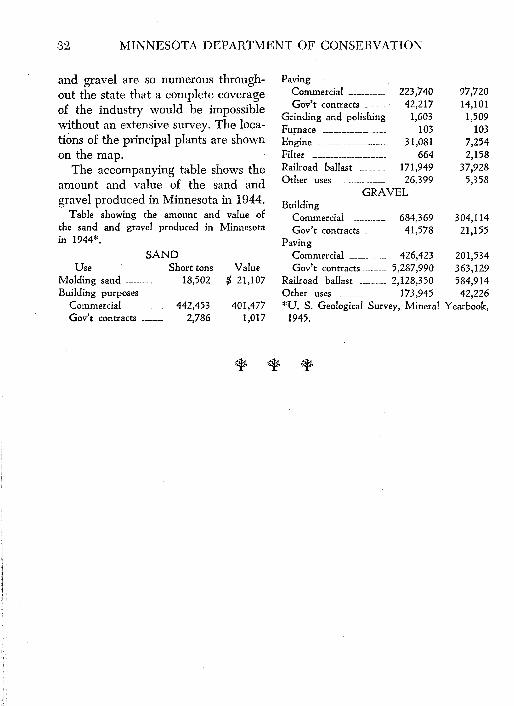
The accompanying table shows the amount and value of the sand and gravel produced in Minnesota in 1944.
Table showing the amount and value of the sand and gravel produced in Minnesota in 1944*.
Railroad ballast __________ 2,128,350 584,914 Other uses __________________ 173,945 42,226 *U. S. Geological Survey, Mineral Yearbook,
1945.
A Portland cement plant is soon to be erected in Minnesota.
Marl Some Deposits Are 50 Feet Thick
George A. Thiel
Marl is a soft earthy material, composed mainly of calcium carbonate ( CaC03 ), that is
found as a freshwater deposit in lake basins and bogs and in marshes or low areas that were once covered with water. Its composition is similar to that of limestone. It is usually grayish-white or buff, but darker colors may be seen where the marl is contaminated with peaty organic matter.
In hardness and consistency fresh marl resembles softened butter. In some of the marsh deposits that are partially drained it is firm enough to be cut into blocks and handled with a shovel, and where compacted under its own weight, marl has the consistency of common mortar when ready for use. In the shallow bays of some lakes where deposition is still in progress, the water may have a milky white appearance due to the suspension of finely divided calcium carbonate, that is kept agitated by wave action.
The manner of deposition of marl is similar to the deposition of the scale in a tea kettle in which "hard" water is boiled. As the water is heated, car-
bon dioxide gas is driven off and this causes the water to become supersaturated with the calcium carbonate. Thus the calcium compound is precipitated from solution and forms a scale in the kettle. In a similar manner the lake water loses carbon dioxide gas through the activity of aquatic plants, such as Chara and Zonotrichia.
All green plants take in carbon dioxide through their leaves and stems. They utilize the carbon in building up the complex molecules of cellulose that serve as the basis of all plant . tissue. Where plants grow in water that c0ntains excess calcium which is held in solution by free carbon dioxide, the extraction of that gas by the growth of the plants causes calcium carbonate to be precipitated.
The source of the calcium in the lake water is the glacial drift with its heterogeneous mass of clay, sand, gravel and boulders that cover most of the state with a mantle more than 100 feet in thickness. In some rngions the drift lies in great level sheets or prames many miles in extent, while elsewhere it is piled up in a
33
34 MINNESOTA DEPARTMENT OF CONSERVATION
great succession of hills, mounds and ridges. Because of its origin this glacial debris contains an appreciable amount of fresh or chemically unaltered rock fragments. In some areas, pebbles of limestone are abundant; in other regions, finely divided rockforming minerals containing calcium compounds constitute a major part of the drift. Soil waters percolating through these limy clays and gravels carry with them dissolved carbon dioxide and the combined action of the dissolved gas and water leaches out the soluble lime compounds from the soils through which it filters. The waters eventually reach the lake basins through seepage springs on the floors of the lakes or as springs on hillsides bordering the lake basins.
From the composition of the drift it has been commonly assumed that the gray limy drift would be a better source of marl than the red stony drift of eastern and central Minnesota. However, a greater number of marl deposits are found in the red drift areas of the state than in the regions of the gray drift. This is due undoubtedly to the differences in texture of the two types of drift. Even though the gray drift contains a higher percentage of calcium carbonate, its texture is so fine-grained that it is relatively impervious, and consequently the leaching action of ground water is retarded.
Since beds of marl owe their origin to the precipitation of lime car-
bonate from solution, it follows that marl is always found in areas that were once covered with water. (See Figure 1) . This does not mean that all deposits are confined to the immediate vicinity of present-day lakes, for during post-glacial time the regional ground-water level has been lowered and many old beach lines of lakes can be traced readily over areas that are now well-drained and cultivated land; marl also underlies partially drained swamps, and in some places it is found in the banks of streams that have cut their channels into a bed of marl as the outlet of a former lake or bog was lowered.
There are hundreds ·of marl deposits in Minnesota, varying from less than a foot to more than 50 feet in thickness. Deposits containing millions of tons occur at Star lake and its vicinity in northern Crow Wing county. Another area of large deposits occurs in a chain of lakes near Monticello and an equally extensive group of marl beds may be seen in a chain of lakes west and south of Clearwater. In the northern part of the state large deposits have been discovered near Bemidji, near Backus and in Riley lake north of Taconite.
Some marl has been excavated and dried to be used as part of the base in manufactured mineral stock foods and for chicken feed where it supplants the crushed clam and oyster shells commonly used for that purpose. The shell marl deposit that oc-
MARL 35
curs near Swanville should make ideal chicken feed.
A considerable tonnage of Minnesota· marl has been used as a neutralizer of acid soils. Nitrifying forage crops such as alfalfa and clover are stunted or even inhibited in their growth by an acid soil condition. Several tons of marl per acre scattered over the soil soon neutralizes the excessive soil acids. Since a great ton-
nage of high grade marl is readily available, more should be used on sandy, siliceous farm lands in order to obtain maximum benefits.
Marl has been used for many years in the manufacture of cement in Indiana and in Michigan. It has been reported recently that a larg-e up-todate plant for making Portland cement will be erected in Minnesota in the near future.
In 1865 there was a 'gold rush' to Lake Vermilion.
Go/~ Silver and Other Metals State Deposits Not Commercially Valuable
George A. Thiel
An island in Lake Vermilion is called Gold Island. It was so named during the 'gold rush' to the lake in 1865 when both gold and silver were discovered there. Much of the land east of the lake that subse-
economic value, but the long record of unsuccessful exploration is not very encouraging.
Silver minerals occur in veins near Pigeon Point, in rocks similar to those that have produced silver in
Ontario near the Minnesota Minnesota's
Mineral boundary. The veins also contain small amounts of the sulphides of lead and zinc (galena and sphalerite) , but
Heritage • • •
quently became valuable for iron ore, was staked for gold claims. In several years it was demonstrated that the gold deposit on the island was too lean and prospecting operations were abandoned.
At~ ti<fld neither of the metals occur
A mine on an island in Rainy Lake, the Little American mine, is the source of the only gold production in Minnesota. It operated in 1894 and 1895 and produced gold valued at $4,635.33. Since that time many veins and gravel deposits have been test-pitted and sampled but no deposits of commercial grade have been discovered.
Small amounts of gold occur in the granites of northern St. Louis and Lake counties, and the general geological conditions are similar to those in a number of gold-producing areas in Ontario. Detailed mapping and prospecting may locate deposits of
36
in sufficient amounts for commercial production. COPPER
The northeastern and east central parts of Minnesota have rocks similar in age and character to the copper-producing rocks of northern Michigan. Test pits have been opened in them at Taylors Falls, Hinckley, Pine City, and at several points between Duluth and Grand Marais. Although copper is present in the rocks, the ore is too lean to be worked commercially.
Various copper minerals occur in veins on Susie Island, near Pigeon Point. A number of the veins have been explored in detail and a shaft has been sunk, but no shipments' of
GOLD, SILVER AND OTHER METALS 37
commercial ore are recorded. Copper boulders, some of which
weigh hundreds of pounds, have been found in the glacial drift. These represent pieces of ore that were plucked from the rocks of the Keweenawan Point area as the glacier that moved from the Labrador Region passed over the copper orebodies.
MANGANESE
Minnesota has noteworthy amounts of manganese, but very little high-grade manganese ore. Oxides of manganese are associated with iron oxides in a number of the ore bodies on the Cuyuna Iron Range. This range has produced manganiferous iron ore since about 1917. The ores are of two general grades: ( 1) black ores in moderate amounts with about 15% manganese, 37% iron and 15% silica; ( 2) brown ores in larger amounts with about 9% manganese, 44% iron and 6% silica.
In addition to the above ores there are large reserves of oxide deposits that have not been marketable be.., cause of high silica content and still larger reserves of fresh rock carrying from five to eight percent of manga-
GEORGE A. THIEL is chairman of the Department of Geology and Mineralogy at the University of Minnesota.
For greater detail about metals the reader is referred to Bulletin 30 of the Minnesota Geological Survey, Mineral Resources of Minnesota, by survey staff members. It is published by the University of Minnesota Press.
nese in the form of various carbonates. Both of these types of lowgrade ore must be concentrated before they can be used by the steel industry.
ALUMINUM
Most metallic aluminum is extracted from the mineral bauxite which is aluminum oxide. This oxide is the product of prolonged weathering and oxidation of minerals with a high percentage of aluminum silicate. There are a number of places in Minnesota where residual kaolinite clays have been leached to such an extent that some silica has been removed and concretionary bauxitic clays have been formed. Such deposits occur along the Minnesota River valley near Morton and at the mouth of Two Rivers near Little Falls. Samples from these deposits assay from 30 to 40 percent alumina (an oxide of aluminum), but this oxide contains only 53 percent of aluminum.
Much research work has been done on high aluminum clays, and it is known that metallic aluminum can be extracted from them, but the processes are too expensive to be commercially practical at the present time. When cheaper methods are developed, Minnesota will be able to supply many millions of tons of relatively pure white clay. MAGNESIUM
The light-weight magnesium occurs as a double carbonate with cal-
38 MINNESOTA DEPARTMENT OF CONSERVATION
cium in the dolomitic limestones of the southeastern counties of Minnesota. The United States Bureau of Mines has reported that dolomite i ock for making magnesium should contain more than 40 percent magnesium carbonate and not less than 97 percent total carbonates. Three marine sedimentary strata in the Paleozoic rocks south and southeast of the Twin Cities meet the above specifications. The oldest stratum occurs in the lower part of the Oneota formation, and is from 10 to 20 feet thick. The next is a unit in the Shakopee dolomite and the youngest is in the upper part of the Cedar Valley limestone. These strata are accessible at many places along the valleys of the Mississippi and Minnesota rivers and millions of tons can be excavated readily.
At the present time magnesium may be extracted more cheaply from sea water and from the minerals magnesite ( MgC03 ) and brucite (Mg(OH) 2 ).
LEAD AND ZINC
Traces of these metals are widespread, but no concentrations that even approach commercial deposits have been discovered.
COBALT
A specimen from a vein near Loon Lake in Cook County was found to contain a small amount of arsenides of cobalt. No other discoveries have been reported.
VANADIUM
The titaniferous magnetites in the gabbro north of Duluth contain small amounts of vanadium. Assays of several of the highly magnetic concentrates produced from lean ore showed as much as 0.50 percent of vanadium oxide ( V 20 5 ) •
TITANIUM
Titanium is present in considerable amounts in the titaniferous magnetite of the Duluth gabbro in Lake and Cook counties. No method for its extraction on a commercial scale has been developed to date.
Minnesota has extensive supplies of wool rock.
Pea~ . Feldspar and Other Non--Metals Will They Support New Industries?
George A. Thiel
PEAT of peat from seven to ten feet thick. The material called peat is partly Locally it may reach a thickness of
decomposed and disintegrated veget- more than 20 feet. The deposits in the able matter that has changed chem- central and southern part of the state ically and physically but still retains are smaller and represent accumula-most of the carbon of the , ______ _, tions of grasses, rushes, cat-:>riginal plant tissues. Many Minnesota's tails and other marsh vegeta
tion. stems, roots, leaves and Mineral seeds are still present in a state of good preservation.
Heritage
From a geologic point of JV~ /Vu.ie
Peat is excavated and used extensively as a fertilizer filler and soil conditioner on
view, peat is the first inter- ,__ ______ , farms, golf courses, gardens, mediate product in the series from nurseries and greenhouses; as packing vegetable matter to coal. material for plants, shrubs, fruit and
There are hundreds of peat de- a variety of fragile objects; as litter posits in Minnesota and from a study for cattle and poultry; as surgical of the topography of the bottoms of dressings, and in the manufacture of the bogs, it is possible to divide them artificial wood, coarse woven fabrics, into two major types: (I) deposits tanning materials, nitrates, ammonium formed by the filling of shallow lakes sulphate, tars and dye-stuffs, etc. or ponds with plant remains and (2) Much of the peat in Minnesota is suitdeposits which have been built up on able for fuel, but at present it is not flat marshy surfaces. Many of the de- in a position to compete with other posits in northern Minnesota are fuels. The estimated tonnage of airknown as "muskeg" swamps which dried peat in this state is more than are largely made up of successive lay- six and one-half billion tons. ers of sphagnum or peat moss. They are the largest, the deepest and Qf the best quality in the state. A single deposit may cover an area of more than 50 square miles with a mantle
FELDSPAR
The feldspars are essentially aluminum silicates containing more or less potassium, sodium, and calcium. These minerals occur mainly in granite, but
39
40 PEAT, FELDSPAR AN DOTHER NON-METALS
the soda-lime feldspars are constituents of darker colored igneous rocks, such as the gabbro that crops. out in the vicinity of Duluth. In exceptionally coarse grained granitic dikes called pegmatites, the feldspar grains may be from three or four inches to more than two feet aoross. Such feldspar is blasted from the rocks and finds a ready market.
Crushed and ground feldspar is used in the manufacture of glazes and metal enamels. It is used also as a flux in the manufacture of glass and in the ceramic industries where it is mixed with clays to make porcelain ware, china, pottery, earthenware, wall and floor tile and other clay products.
The only feldspar mine in Minnesota is located in the Northwest Angle northwest of Lake of the Woods. The hand-picked ore is carried by barge to a mill at Warroad where it is crushed and bagged for shipment to various manufacturers. WooL RocK
Fibrous insulating materials made from rock is known in industry as rock wool. The raw material commonly used for making the fine glassy fibers is a clayey limestone or dolomite. If such rocks have a carbon dioxide content of 20 to 30 percent, they can be satisfactorily melted and blown into wooly fibers. Analyses of Minnesota limestones and dolomites indicate that most of the St. Lawrence dolomite which is about 30 feet thick and thinner layers in the Platte-
ville, Galena and Oneota dolomites are wool rocks.
A plant at Mankato uses an argillaceous dolomite near the base of the Oneota formation and the rock wool plant at Red Wing has quarried and used many tons of the St. Lawrence dolomite.
There is virtually an unlimited supply of suitable wool rock in the sedimentary strata of southeastern Minnesota. POTASH-BEARING MINERALS
The Franconia formation that occurs at or near the surface along the valleys of the St. Croix and Mississippi rivers contains an appreciable amount of the mineral glauconite. This mineral is essentially a hydrous silicate of iron and potassium. At some places the glauconite contains seven or eight percent of potash. Although this potash is only slightly soluble in water, small amounts of it are available for plant use. For this reason glauconitic sands are used as a fertilizer filler with some success. Because of its base-exchange characteristics, glauconite is used extensively also for water softening. There are accessible locations near rail or river transportation where millions of tons of highly glauconitic sands and silts can be excavated in east central and southeastern Minnesota. SULPHUR COMPOUNDS
There are no deposits of pure sulphur known in Minnesota; however, compounds of sulphur and iron are
THE CONSERVATION VOLUNTEER 41
common sources of sulphur. If at some future date large quantities of sulphuric acid are needed for leaching and concentrating low-grade ores or for other chemical processes, sulphides of iron might be obtained in commercial amounts at· several points in the region of Long Lake, about 12 miles southeast of Aitkin. Preliminary drilling has demonstrated the presence of both pyrite and pyrrhotite in the graphitic slates of that area. Pyrite, FeS2 (Fool's Gold) is a very common mineral and it is present· in small amounts in a great variety of rocks; however, few large deposits are known. ';RAPIDTE
The graphite in metamorphic rocks such as slate and schist is a residue dilrived from the cellulose of plant tissue that was deposited in the sediments from which the rocks were formed. Graphitic slates are very common in northern Minnesota and at several places test pits have been excavated in an attempt to locate material of commercial grade. A pit northwest of Mahtowa is in the Carlton slates; one on Pigeon Point is in gray quartzite and another in that area has small quantities of graphite in the "red rock." No commercial deposits have been found. GAS AND OIL
Methane or marsh gas has been
encountered in the glacial drift in numerous areas. It occurs in pockets that "bounce the tools" as well-drillers penetrate them. Occasionally it throws out quantities of mud and other rock debris. These "puffs" are of short duration and further drilling does not increase the How of gas. The highest pressure recorded is 22 pounds. Such pressures subside in a few hours, but small quantities of gas may issue from the wells for many years. No methane has been encountered in holes drilled into the bedrock beneath the glacial drift.
There has been considerable drilling for oil in Minnesota beginning as early as 1887. However, the age and structure of the rocks are such that commercial production is very doubtful. There has been an occasional leak from some storage tank of gasoline or fuel oil into the soil and glacial drift, which created much unjustified hope of commercial accumulation of petroleum.
SALT
No deposits of rock salt are known in Minnesota, but many wells produce salt water. This is especially true in the Red River Valley region where salt was obtained from brine as early as 1884. Although there are numerous salt springs, no large brine industry has developed.