40
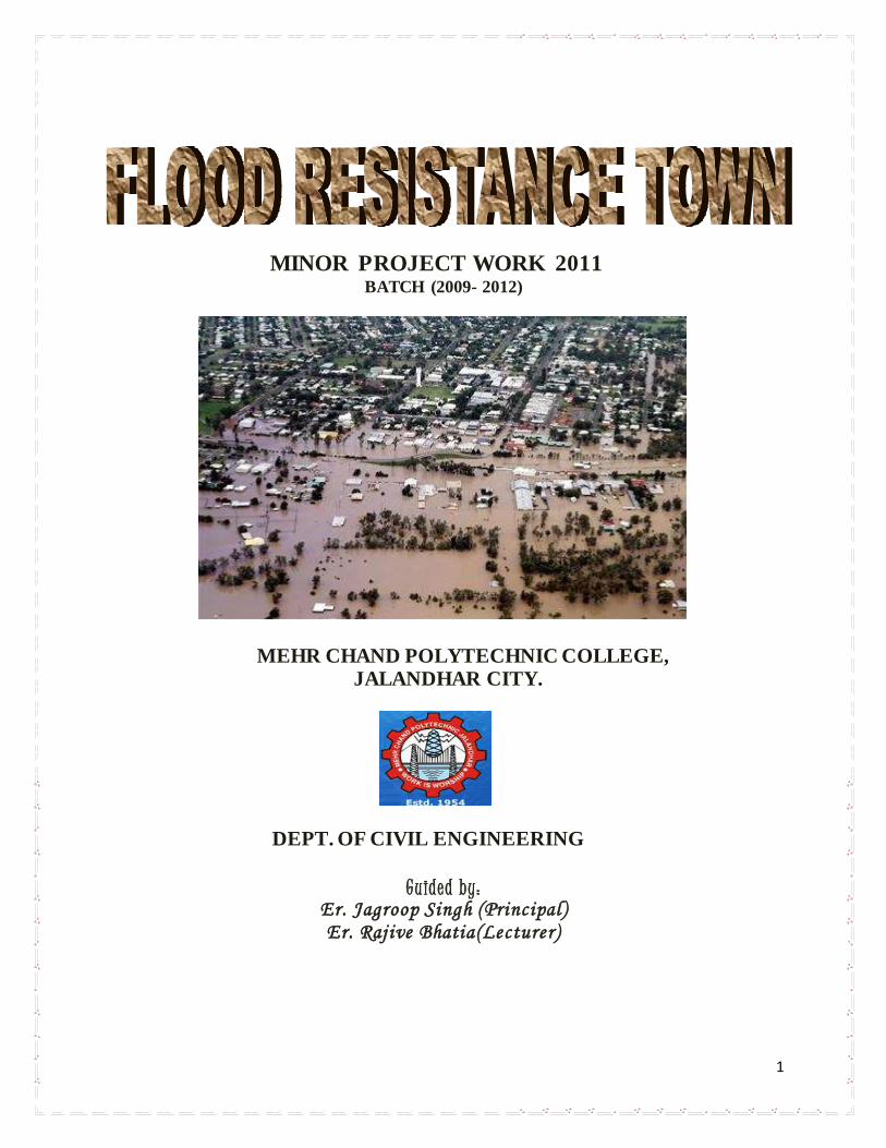
1 MINOR PROJECT WORK 2011 BATCH (2009- 2012) MEHR CHAND POLYTECHNIC COLLEGE, JALANDHAR CITY. DEPT. OF CIVIL ENGINEERING Guided by: Er. Jagroop Singh (Principal) Er. Rajive Bhatia(Lecturer)
| Date post: | 15-Jul-2015 |
| Category: |
Engineering |
| Upload: | jaspreet-singh |
| View: | 65 times |
| Download: | 1 times |
1
MINOR PROJECT WORK 2011 BATCH (2009- 2012)
MEHR CHAND POLYTECHNIC COLLEGE, JALANDHAR CITY.
DEPT. OF CIVIL ENGINEERING
Guided by: Er. Jagroop Singh (Principal) Er. Raj ive Bhatia(Lecturer)

2
CONTENTS
Introduction
1.1 Flood
1.2 Causes of Flood
1.2.1 Heavy Rainfall
1.2.2 Highly Accelerated Snowmelt
1.2.3 Severe Winds over Water
1.2.4 Unusual High Tides
1.2.5 Failure of Dams, Levees Or Other Structures
1.3 Effect of Flood
1.3.1 Primary Effects
1.3.2 Secondary Effects
1.3.3 Tertiary/Long-Term Effects
1.4 Types of Flood
1.4.1 According To Their Duration
1.4.1.1 Flash Floods
1.4.1.2 Slow-Onset Floods

3
1.4.1.3 Rapid-Onset Floods
1.4.2 according to Their Location
1.4.2.1 Coastal Flooding
1.4.2.2 Arroyos Floods
1.4.2.3 River Floods
1.4.2.4 Urban Floods
1.5 Flood Disaster Management
1.5.1 Structural Measures (Flood Control)
1.5.1.1 Dams and Reservoir
1.5.1.2 Flood Wall
1.5.1.2.1 Gravity Wall
1.5.1.2.2 Buttress Retaining Wall
1.5.1.2.3 Cellular Concrete Walls
1.5.1.2.4 Folding Floodwall
1.5.1.2.5 Sheet Pile Cells
1.5.1.3 Flood Gates
1.5.1.4 Valves

4
1.5.1.5levees
1.5.1.6 Sand Dykes
1.5.1.7 Interlinking Of Rivers
1.5.1.8 Tunnel
1.5.2 Non-Structural Measures
1.5.2.1 Flood Plain Management
1.5.2.2 Flood Proofing
1.5.2.3 Classification of Flood Proofing
1.5.2.4 Fema Recommended Methods
1.5.2.4.1 Elevation
1.5.2.4.2 Wet Flood Proofing
1.5.2.4.3 Dry Flood Proofing
1.5.2.4.4 Relocation
1.5.2.4.5 Demolition
1.5.2.3 Flood Fighting and Disaster Relief
1.6 Conclusion

5
ACKNOWLEDGEMENT
First of all thankful to you to almighty to giving strength for complete this project work. The
project is the product of valuable contribution of many people to whom I will remain thankful.
My sincere thanks are due to Principal Jagroop Singh for sparing his valuable time in guide this
project work. His knowledge pool and timely suggestions are praise worthy.
I am sincerely thankful to Sh. Sanjay Mahajan ( Incharge ,Civil Engineering) for his support.
I take an opportunity to convey my heart- felt indebting to Sh. Rajeev Bhatia, Lect. for this study
work. His guidance, suggestions, and healthy criticism helped us to complete the project well in
time.
Finally, I most acknowledge my sincere gratitude to the staff of Civil Engineering department
for updating us in various aspects.
GROUP “F”
6
IMPORTANCE OF PROJECT
Past work
When the river are proceed in a town, due to excessive water there will a chances of flood. As if
we see the last records than a result is come out there was a lot of harmful effect was on the lives
and also on the property. In ancient time the people are not aware about the fact of flood. There
was very less techniques used for protection from flood and they were prayers to the rain god for
stopping of rain so that the level of water will comes down. They did yagas and mantra pooja for
this purpose but after sometimes with passing of time they start to find out what can be done for
flood protection. With passing of time, people use to make a lining of trees around the river
embankment and use the sand bags and making a lining toward bank of river. The main think of
people is to evacuate from there region where is chances of floods and to reach at the station
which level is high than high flood level. But with a new advance technology there are different
measures are accepted for prevention from flood which are described further.
Present work
With the change of scenario, different techniques are used for flood control. The people are very
aware about this concept. They are taking right steps toward for prevention from flood. Now the
days the different techniques are used in India in which first of all Dams and Reservoir are used
for storage the excess water and flood gates, flood valve are used to control the level and
pressure of water. Flood wall and levees is widely used for protection from flood. In case of
detention basin and interlinking of rivers the water is transferred from one place to other by
doing which the water can be used where scarcity of water. In flood plain management, basic

7
concept is to regulate the land use in flood plain in order to restrict the damage potential due to
floods. In flood proofing, we can construct a house which can be protected fully from flood.
Future work
The techniques which are uses very successful but sometimes due to high level and pressure of
that are not safe. Sometimes the flood is of so high pressure that cannot be prevented so there are
also new techniques are used for solving this problem. Tunnel is one of the major new
techniques. In this method an underground tunnel is to be constructed near flood prone area and
when there is a chance of flood than that water will be flush out from that place easily and large
amount of discharge can be done and after that, the water can be used for different purpose. But
this techniques has also a drawbacks that are the cost of this project is higher and such type of
constructing a tunnel is self a big challenge.

8
INTRODUCTION
Flood is most destructive natural disaster which extensively damages the life and property in
India. It is very difficult to predict flood, because of its nature. It may be rightly stated that such
types of natural calamities leave behind a story of death, hunger, epidemic and mass destruction.
Flood is natural phenomenon, whose roots are in monsoon rainfall. It means that it is the result of
rainfall. Out of the total annual rainfall in the country, 75 per cent is concentrated over a short
monsoon season of three to four months. As a result there is a large amount of discharge from
rivers during the monsoon period causing floods.
It has been seen in India that most part of north-eastern India are more frequently hit by the
severe floods. This entire region is ecologically fragile with respect to flood because of large
river system of the country with its hundreds of tributaries. Floods are increasing in India with
respect to intensity, magnitude and frequency.
1.1 FLOOD
A temporary rise of the water level, as in a river or lake or along a seacoast, resulting in its
spilling over and out of its natural or artificial confines over land is known as flood. Flooding
may result from the volume of water within a body of water, such as a river or lake which
overflows or breaks levees, with the result that some of the water escapes its usual boundaries.

9
1.2 CAUSES OF FLOOD
There are different causes of flood due to which flood comes that are following;
1) Heavy rainfall
2) Highly accelerated snowmelt
3) Severe winds over water
4) Unusual high tides
5) Tsunamis
6) Failure of dams, levees, retention ponds or other structures that retained the water.
1.2.1 Heavy Rainfall
The main reason behind flood is a rainfall. During times of rain, some of the water is retained in
ponds or soil, some is absorbed by grass and vegetation, some evaporates, and the rest travels
over the land as surface runoff. Floods occur when ponds, lakes, riverbeds, soil, and vegetation
cannot absorb all the water. Water then runs off the land in quantities that cannot be carried
within stream channels or retained in natural ponds, lakes, and man-made reservoirs. About 30
percent of all precipitation is in the form of runoff small and that amount might be increased by
water from melting snow. River flooding is often caused by heavy rain.
10
1.2.2 Highly accelerated snowmelt
In this cause the snow will start to melt and due to the melting of snow the water in the river
reach its maximum value. This is generally due to the global warming; the snow will start melt in
contact of sun glare and change in to the form of water. That water reach into rivers and cause
flood.
1.2.3 Severe winds over water
Even when rainfall is relatively light, the shorelines of lakes and bays can be flooded by severe
winds—such as during hurricanes—that blow water into the shore areas.
1.2.4 Unusual high tides
Coastal areas are sometimes flooded by unusually high tides, such as spring tides, especially
when compounded by high winds and storm surges.
1.2.5 Failure of dams, levees or other structures
Sometimes the structures which are used for flood resistance that are break and the water stored
and resistance water will come in city and cause of urban flooding.
1.3 EFFECTS
Precisely, the flood hazards have the following impacts on the various anthropogenic activities
including two major sectors i.e. agriculture and socioeconomic conditions of society;

11
1.3.1 Primary effects
Physical damage – Can damage any type of structure, including bridges, cars, buildings,
sewerage systems, roadways, and canals.
1.3.2 Secondary effects
a) Water supplies – Contamination of water. Clean drinking water becomes scarce.
b) Diseases – Unhygienic conditions. Spread of water-borne diseases.
c) Crops and food supplies – Shortage of food crops can be caused due to loss of entire
harvest. However, lowlands near rivers depend upon river silt deposited by floods in
order to add nutrients to the local soil.
d) Trees – Non-tolerant species can die from suffocation.
e) Transport - Transport links destroyed, so hard to get emergency aid to those who need
it.
1.3.3 Tertiary/long-term effects
Economic – Economic hardship, due to: temporary decline in tourism, rebuilding costs, food
shortage leading to price increase, etc.

12
1.4 TYPES OF FLOOD
1.4.1 According to their Duration
Flood can be classified into three types according to their duration are following:
1.4.1.1 Flash floods
In areas with steep slopes, heavy rain can cause a riverbed that held very little or no water at
first, to suddenly brim with fast flowing water. The rain water is collected on the slopes, then
flows downhill gathering speed and all the water comes together in the river bed. The water level
rises fast. The water flows over the river banks and floods the area. Speed is the keyword. It all
happens fast, it rains heavily. The water flows at high speed. Because of this speed it has the
strength to carry away heavy objects as Ladakh region of Himachal Pradesh in aug.2010. More
than 200 people were injured and 60 were killed. A flash flood is a very direct response to
rainfall with a very high intensity or sudden massive melting of snow.
The area covered by water in a flash flood is relatively small compared to other types of floods.
The amount of water that covers the land is usually not very large, but is so concentrated on a
small area that it can raise very high.
Because of the sudden onset and the high travelling speed of the water, flash floods can be very
dangerous. The water can transport large objects like rocks, trees and cars. Never drive through a
flash flood, even if it doesn’t seem to be very deep: the car may be swept away by the sheer
speed of the water.
13
1.4.1.2 Slow-Onset Floods
Slow-Onset Floods usually last for a relatively longer period; it may last for one or more weeks,
or even months. As this kind of flood last for a long period, it can lead to lose of stock, damage
to agricultural products, roads and rail links.
1.4.1.3 Rapid-Onset Floods
Rapid-Onset Floods last for a relatively shorter period; they usually last for one or two days only.
Although this kind of flood lasts for a shorter period, it can cause more damages and pose a
greater risk to life and property as people usually have less time to take preventative action
during rapid-onset floods.
1.4.2According to their Location
Flood can be classified into three types according to their duration are following:
1.4.2.1 Coastal flooding
Simply put a coastal flood is when the coast is flooded by the sea. The cause of such a surge is a
severe storm. The storm wind pushes the water up and creates high waves.
A flood starts when waves move inland on an undefended coast or overtop or breach the coastal
defense works like dunes and dikes. The waves attack the shore time and again. When it is a
sandy coast, each wave in a storm will take sand away. Eventually a dune may collapse that way.

14
1.4.2.2 Arroyos Floods
An arroyo is river which is normally dry. When there are storms approaching these areas, fast-
moving River will normally form along the gully and cause damages.
1.4.2.3 River Floods
This is the most common type of flooding. When the actual amount of river flow is larger than
the amount that the channel can hold, river will overflow its banks and flood the areas alongside
the river. And this may cause by reasons like snow melt or heavy spring rain.
1.4.2.4 Urban Floods
In most of the urban area, roads are usually paved. With heavy rain, the large amount of rain
water cannot be absorbed into the ground and leads to urban floods.
1.5 FLOODS IN INDIA
India is most affected nation in the world. It accounts for one fifth of global deaths due to the
floods and on average thirty million people are evacuated every year. So flood in India is not a
new phenomenon. Unprecedented floods take place every year in one state or another of the
country. India has been traditionary affected by flood. The vulnerability of the states of India due
to floods was not observed severely in past due to low development activities and lack of
population interest. However, in the present has forced of houses the occupation on flood plains
and this makes the society highly vulnerable to flood losses.
India is one of the richest countries in the world with regard to its water resources and it is
continuously affected by its natural sources in the form of floods. India receives 75 per cent of its
15
total annual rainfall in just 100 hours of four months of rainy season. In monsoon, all rivers flow
with large amount of water. These rivers bring floods to the plain areas because of the low slopes
and the fast flow of the water. In the last few decades in India the magnitude and the intensity of
flood occurrence has increased tremendously. According to CCE(Centre for society and
Environment), in the present time floods are not only a research issue but have now become a
critical topic to think about for the environmentalist, hydrologist, geographers and for other
disciplines also. Now the need for proper management of water has been felt due to the floods.
In India, 22 states and one union territory (Andaman &Nicobar) are vulnerable to floods.
However, the most vulnerable states of India are Uttar Pradesh, Bihar, West Bengal,
Maharashtra, Punjab and Jammu.
1.5 FLOOD DISASTER MANAGEMENT
The various measures adopted for flood disaster management may be categorized into two
groups:
Structural
Non-structural
16
1.5.1 Structural Measures (Flood Control)
The general approach was aimed at preventing floodwaters from reaching the potential damage
centre, as a result of which a large number of embankments came up along the various flood
prone rivers. The main thrust of the protection program undertaken in the country so far in the
form of structural measures which may be grouped into the following;
1) Dams and Reservoir
2) Flood gates
3) Flood walls
4) Flood valves
5) Levees
6) Dikes
7) Interlinking of rivers.
8) Tunnel
1.5.1.1 Dams and Reservoir
Dams and reservoir are the storage work, constructed for storing water and utilizing the same for
irrigation and other purposes. Dams are constructed for the purpose of storing water on the u/s
side and forming a lake or pool of water generally called a Reservoir. The construction of a dam
is a major irrigation project because it requires greater understanding in planning and design. An
obstruction or a barrier built across the stream or river is known as Dam.

17
Dams: A solid barrier impervious in nature and constructed across the narrow portion in
valley/stream/rivers is called dam. There are different types of dams according to their use but
dams which detain the flood at various places is termed is known as detention dams or debris.
Flood control Reservoir: A pool or lake of water formed on the upstream side of the solid
barrier constructed at right angles to the flow is known as reservoir and the reservoir which
stores a portion of the flood in such a way so as to minimize the flood peaks at the area to be
protected on the downstream side of the reservoir is called flood control reservoir or flood
mitigation reservoir. There are two types of flood control reservoir: Storage or detention
reservoir and Retarding reservoir.
Fig FR-1 The Bhakhra-nangal dam reservoir, Himachal Pradesh, India

18
1.5.1.2 FLOOD WALL
A flood wall is a primarily vertical artificial barrier designed to temporarily contain the waters of
a river or other waterway which may rise to unusual levels during seasonal or extreme weather
events. Flood walls are mainly used on locations where space is scarce, such as cities or
building levees or dikes would interfere with other interests, such as existing buildings, historical
architecture or commercial exploitation of embankments.
Flood walls are nowadays mainly constructed from pre-fabricated concrete elements. Flood walls
often have "flood gates" which are large openings to provide passage except during periods of
flooding, when they are closed. As flood walls mostly consist of relatively short elements
compared to dikes, the connections between the elements are critical to the failure of flood walls.
1.5.1.2.1 Gravity Wall
A gravity wall consists of mass concrete, generally without reinforcement which gains its
stability from the mass of the wall.
Figure FP- 2 Example of Gravity Wall
19
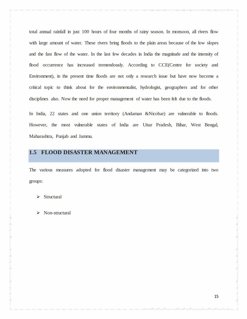
1.5.1.2.2 Buttress Retaining Wall
A buttress retaining wall is similar to a T Wall, except that it is used where the stem of the wall is
long. To reduce stresses in the stem, it contains buttresses at intervals along the wall to tie the
stem and base slab together.
1.5.1.2.3 Cellular Concrete Walls
Cellular concrete walls function similar to concrete gravity walls. However, instead of a solid
mass of concrete, the weight of the wall is a combination of the concrete cell and the weight of
the soil contained by the cell
Figure FP- 4 Example of Buttress Retaining Wall

20
1.5.1.2.4 Folding Floodwall
The folding floodwall consists of a flood barrier which is hinged along the bottom so that it can
be lowered to a horizontal position to form a walk, or to fit flush with existing ground or
pavement. A floodwall in Monroe, Louisiana is based on this concept.
Figure FP- 5 Example of Folding Flood Wall
1.5.1.2.5 Sheet Pile Cells
Flood Wall Constructed with Steel Sheet Pile Cellular Structures.
`
Figure FP- 7 Examples of A cellular sheet pile cells
21
1.5.1.3 FLOOD GATES
Floodgates are adjustable gates which are used to control water flow of water in flood
barriers, reservoir, river, stream, or levee systems. They may be designed to set spillway crest
heights in dams, to adjust flow rates in sluices and canals, or they may be designed to stop water
flow entirely as part of a levee or storm surge system. Since most of these devices operate by
controlling the water surface elevation being stored or routed, they are also known as crest gates.
In the case of flood bypass systems, floodgates sometimes are also used to lower the water levels
in a main river or canal channels by allowing more water to flow into a flood bypass or detention
basin when the main river or canal is approaching a flood stage.
1.5.1.4 VALVES
Valves used in floodgate applications have a variety of design requirements and are usually
located at the base of dams. Often, the most important requirement (besides regulating flow) is
energy dissipation. Since water is very heavy, it exits the base of a dam with the enormous force
of water pushing from above. Unless this energy is dissipated, the flow can erode nearby rock
and soil and damage structures.
Other design requirements include taking into account pressure head operation, the flow rate,
whether the valve operates above or below water, and the regulation of precision and cost.

22
1.5.1.5 LEVEES
The aim of levees is to prevent floodwater getting close to a property. The levees act as barriers,
and are situated within a certain distance of the property.
The barriers can be divided into two sorts: natural and unnatural materials. Levees are natural
barriers made of clay, sand or sandy clay. The unnatural (floodwall) types are made of cement
block bricks or poured concrete. Next to the barriers, a sump pump has to be installed to control
the seepage or infiltration. All openings within the barrier should be equipped with a closure. A
levee is typically a compacted earthen structure. The practical heights of these levees and
floodwalls are usually limited to 6 feet and 4 feet, respectively.
Figure-Leeves
23
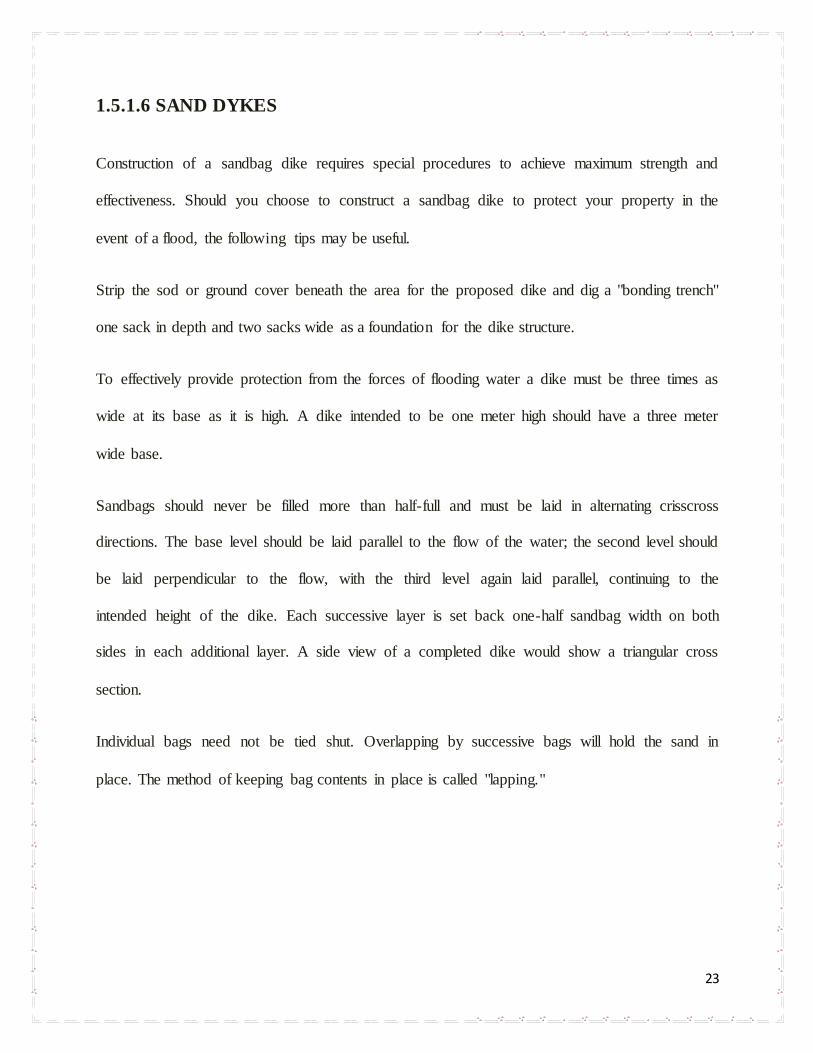
1.5.1.6 SAND DYKES
Construction of a sandbag dike requires special procedures to achieve maximum strength and
effectiveness. Should you choose to construct a sandbag dike to protect your property in the
event of a flood, the following tips may be useful.
Strip the sod or ground cover beneath the area for the proposed dike and dig a "bonding trench"
one sack in depth and two sacks wide as a foundation for the dike structure.
To effectively provide protection from the forces of flooding water a dike must be three times as
wide at its base as it is high. A dike intended to be one meter high should have a three meter
wide base.
Sandbags should never be filled more than half-full and must be laid in alternating crisscross
directions. The base level should be laid parallel to the flow of the water; the second level should
be laid perpendicular to the flow, with the third level again laid parallel, continuing to the
intended height of the dike. Each successive layer is set back one-half sandbag width on both
sides in each additional layer. A side view of a completed dike would show a triangular cross
section.
Individual bags need not be tied shut. Overlapping by successive bags will hold the sand in
place. The method of keeping bag contents in place is called "lapping."
24
Fig FS 1 sand dykes
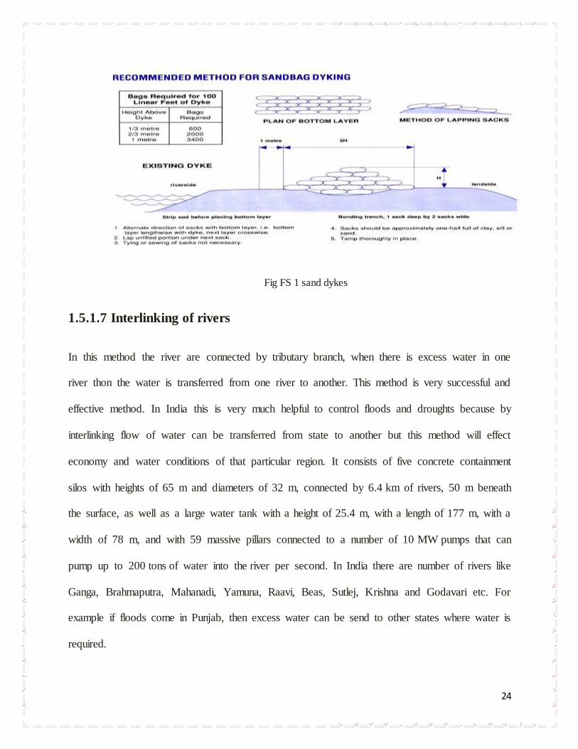
1.5.1.7 Interlinking of rivers
In this method the river are connected by tributary branch, when there is excess water in one
river thon the water is transferred from one river to another. This method is very successful and
effective method. In India this is very much helpful to control floods and droughts because by
interlinking flow of water can be transferred from state to another but this method will effect
economy and water conditions of that particular region. It consists of five concrete containment
silos with heights of 65 m and diameters of 32 m, connected by 6.4 km of rivers, 50 m beneath
the surface, as well as a large water tank with a height of 25.4 m, with a length of 177 m, with a
width of 78 m, and with 59 massive pillars connected to a number of 10 MW pumps that can
pump up to 200 tons of water into the river per second. In India there are number of rivers like
Ganga, Brahmaputra, Mahanadi, Yamuna, Raavi, Beas, Sutlej, Krishna and Godavari etc. For
example if floods come in Punjab, then excess water can be send to other states where water is
required.

25
1.5.1Tunnels
The stormwater management and road tunnel or SMART tunnel is a storm drainage and road
structure. The main objective of this tunnel is to solve the problem of flash floods and also to
reduce traffic jams. There In simple words we can say it is a drainage pipe with larger dia of 10-
15 meters. Construction cost of this project very high but benefits overcomes the construction
cost. Here is estimation cost to construct a one kilometer, regional cost varies are two
components of this tunnel, the stormwater tunnel and motorway tunnel. Storm water tunnel.
Construction cost: US$5146 thousand
Stormwater tunnel length: 1km
Diameter: 13.2 m (43.3 ft)
Tunneling method: tunnel boring machine (TBM)
In India these type of smart tunnel can be used in Delhi during monsoons the outer regions on the
river (Yamuna) bank flooded away by the flow. And lots people die, many became homeless so

26
to protect them SMART tunnel can be constructed over there and flow of water can be changed
to other regions of Delhi and to some parts of Rajasthan. By the construction of this SMART
tunnel traffic problem of Delhi can be solved because is one of the city of India which is
suffering from heavy traffic problem. During monsoons these tunnels can be used for drainage
purpose and rest of the 8-10 months these can be used to control traffic problem.
The Metropolitan Area Outer Underground Discharge Channel also known as the G-Cans
Project, is an underground water infrastructure project built for preventing overflow of the city's
major waterways and rivers during rain.
It consists of five concrete containment silos with heights of 65 m and diameters of 32 m,
connected by 6.4 km of tunnels, 50 m beneath the surface, as well as a large water tank with a
height of 25.4 m, with a length of 177 m, with a width of 78 m, and with 59 massive pillars
connected to a number of 10 MW pumps that can pump up to 200 tons of water into the river per
second.
This type of tunnel can be constructed where the problem of water is more rather than the
problem of traffic but this type can only b used for drainage only or as a tourist spot.
As these tunnels consist of tanks at some distance so they can store very high quantity of water
therefore water can be conserved here for future use and even can be treated over here to make it
drinkable by using WTP.
27
1.5.2 Non-Structural Measure
The non structural measures, on the other hand, aim at modifying the susceptibility to flood
damage as well as modifying the loss burden. The various non–structural measures being
implemented in the country are:
A. Modifying the susceptibility to flood damages through
Flood plain management
Flood proofing
B. Modifying the flood loss burden through
Disaster relief
Flood fighting including public health measures
1.5.2.1 Flood plain management
The basic concept is to regulate the land use in flood plain in order to restrict the damage
potential due to floods. The Rashtriya Barh Ayog and Central Water Commission recommended
that flood plain management measures should be undertaken and suitable management
legislation enacted. This zoning is done by floods of different magnitudes or frequencies and
then to develop such areas where the damage is minimu1)1)m in case floods do occur. Therefore,
flood plain zoning aims to regulate the indiscriminate and unplanned protected areas. It
recognizes the basic fact the flood plains are essentially the domain of the river, and as such all
development activities in flood plains must be compatible with the flood risk involved.

28
1.5.2.2 FLOOD PROOFING
Flood proofing is any combination of structural or non-structural changes or adjustments
incorporated in the design, construction, or alteration of individual buildings or properties that
will reduce flood damages.
APPLICATION: Such measures help greatly in the management of disaster for the population
in flood prone areas. It is essentially a combination of structural change and emergency action
without evacuation. A programme for flood proofing provides the raised platforms for flood
shelters for men and cattle and raising the public utility installation above flood levels. Under
this programme, several villages were raised in Uttar Pradesh. In West Bengal and Assam,
landfills were attempts in villages to keep houses above flood level in some areas. In the Eighth
plan, the flood proofing programme was proposed for the Ganga basin states, particularly for
North Bihar areas.
1.5.2.3 Classification of Flood Proofing
Flood-proofing techniques can be classified on the basis of the type of protection that is provided
as follows:
(1) Permanent measures—always in place, requiring no action if flooding occurs.
(2) Contingent measures—requiring installation prior to the occurrence of flood.
(3) Emergency measures—improvised at the site when flooding occurs.
In the Denver metropolitan area, flood-proofing efforts should focus on permanent measures due
to the rapid response of most of the Front Range stream systems. Contingent measures are more

29
effective when combined with an early flood warning system or in areas not immediately
adjacent to a stream channel.
1.5.2.4 FEMA Recommended Methods
The Federal Emergency Management Agency (FEMA) has published numerous references on
the subject of flood proofing (FEMA 1984, 1986a, 1986b, 1991, 1993a, 1993b, 1993c, 1993d,
1993e, 1994, 1995, 1996). In several of these documents, FEMA outlines six methods of flood
proofing as follows:
(1). Elevation—raising the structure so that the lowest floor is above the flood level.
(2). Wet Flood Proofing—Making uninhabited portions of the structure resistant to flood
damage and allowing water to enter during flooding.
(3). Relocation—moving the structure out of the floodplain to higher ground where it will not
be exposed to flooding.
(4). Dry Flood Proofing—sealing the structure to prevent floodwaters from entering.
(5). Demolition—tearing down the damaged structure and either rebuilding properly on the
same property or buying or building outside the floodplain.
1.5.2.4.1 Elevation
Elevating a building to prevent floodwaters from reaching living areas is an effective retrofitting
method. The goal of the elevation process is to raise the lowest floor to or above the flood
protection elevation (FPE) as shown in Figure FP-4. This can be done by elevating the entire

30
building, including the floor, or by leaving the building in its existing position and constructing a
new, elevated floor within the building. The method used depends largely on construction type,
foundation type, and flooding conditions.
During the elevation process, most buildings are separated from their foundations, raised on
hydraulic jacks, and held by temporary supports while a new or extended foundation is
constructed below. This method works well for buildings originally built on basement, crawl
space, and open foundations. As explained later in this section, the new or extended foundation
can consist of continuous walls or separate piers, posts, columns, or pilings.
Figure FP-1—Example of a Structure Elevated on Continuous Foundation Walls
A variation of this method is used for buildings on slab-on-grade foundations. In these buildings,
the slab forms both the foundation and the floor of the building. Elevating these buildings is
easier if the building is left attached to the slab foundation and both are lifted together. After the
building and slab are lifted, a new foundation is constructed below the slab.

31
Alternative techniques are available for masonry buildings on slab-on-grade foundations. These
techniques do not require the lifting of the building. Instead, they involve raising the floor within
the building or moving the living space to an upper story.
Although elevating a building can help protect it from floodwaters, other hazards need to be
considered before choosing this method (Table FP-1). The walls and roof of an elevated building
may be more susceptible to wind forces because they are higher and more exposed. In addition,
both continuous wall foundations and open foundations can fail as a result of damage caused by
erosion and the impact of debris carried by floodwaters.
1.5.2.4.2 Wet Flood Proofing
Wet flood proofing a building is done by modifying the uninhabited portions (such as a crawl
space or an unfinished basement) so that floodwaters will enter but not cause significant damage
to either the building or its contents. The purpose of allowing water into portions of the building
is to ensure that the interior and exterior hydrostatic pressures will be equal (Figure FP-5).
Allowing these pressures to equalize greatly reduces the likelihood of wall failures and structural
damage. Wet flood proofing is often used when all other retrofitting methods are either too costly
or are not feasible, but it is practical in only a limited number of situations. The advantages and
disadvantages of wet flood proofing are summarized in 1.4.2.1.

32
Figure FP-2—Example of a Building With a Wet Flood-Proofed Sub grade Basement
Because wet flood proofing allows floodwaters to enter the building, all construction and
finishing materials below the FPE must be resistant to flood damage. For this reason, wet flood
proofing is practical only for portions of a building that are not used for living space, such as a
basement as defined by the NFIP regulations, a walkout-on-grade basement, crawl space, or
attached garage. It would not be practical for most slab-on-grade buildings, in which the living
space is at or very near the ground level. Whether or not wet flood proofing is appropriate for a
building will depend on the flood conditions, the FPE selected, the design and construction of a
building, and whether the building has been substantially damaged or is being substantially
improved.
1.5.2.4.3 Dry Flood Proofing
In some situations, a building can be made watertight below the FPE, so that floodwaters cannot
enter. This method is called dry flood proofing. Making the building watertight requires sealing
the walls with waterproof coatings, impermeable membranes, or supplemental layers of masonry
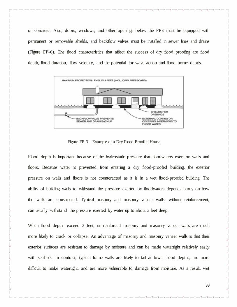
33
or concrete. Also, doors, windows, and other openings below the FPE must be equipped with
permanent or removable shields, and backflow valves must be installed in sewer lines and drains
(Figure FP-6). The flood characteristics that affect the success of dry flood proofing are flood
depth, flood duration, flow velocity, and the potential for wave action and flood-borne debris.
Figure FP-3—Example of a Dry Flood-Proofed House
Flood depth is important because of the hydrostatic pressure that floodwaters exert on walls and
floors. Because water is prevented from entering a dry flood-proofed building, the exterior
pressure on walls and floors is not counteracted as it is in a wet flood-proofed building. The
ability of building walls to withstand the pressure exerted by floodwaters depends partly on how
the walls are constructed. Typical masonry and masonry veneer walls, without reinforcement,
can usually withstand the pressure exerted by water up to about 3 feet deep.
When flood depths exceed 3 feet, un-reinforced masonry and masonry veneer walls are much
more likely to crack or collapse. An advantage of masonry and masonry veneer walls is that their
exterior surfaces are resistant to damage by moisture and can be made watertight relatively easily
with sealants. In contrast, typical frame walls are likely to fail at lower flood depths, are more
difficult to make watertight, and are more vulnerable to damage from moisture. As a result, wet

34
flood proofing is not recommended for buildings with frame walls that will be damaged by
moisture.
Dry flood proofing may not be used to bring a substantially damaged or substantially improved
building into compliance with a community’s floodplain management ordinance or law.
1.5.2.4.4 Relocation
Moving a building to high ground, outside the flood hazard area, is the most effective of the
retrofitting methods described in this Manual. Retrofitting literature commonly refers to this
method as relocation. When space permits, it may even be possible to move a building to another
location on the same piece of property.
Relocating a building usually involves jacking it up and placing it on a wheeled vehicle, which
delivers it to the new site. The original foundation cannot be moved, so it is demolished and a
new foundation is built at the new site. The building is installed on the new foundation and all
utility lines are connected.
Relocation is particularly appropriate in areas where the flood hazard is severe. Relocation is
also appropriate for those who want to be free of worries about damage from future floods that
may exceed a selected FPE.
Although similar to elevation, relocation requires additional steps that usually make it more
expensive. These include moving the building, buying and preparing a new site (including
building the new foundation and providing the necessary utilities), and restoring the old site
(including demolishing the old foundation and properly capping and abandoning old utility
lines).

35
1.5.2.4.5 Demolition
Demolition, as a retrofitting method, is tearing down a damaged building and either rebuilding
properly somewhere on the same property or moving to a building on other property outside the
regulatory floodplain. This retrofitting method may be the most practical of all those described in
this Manual when a building has sustained extensive damage, especially severe structural
damage.
Whether rebuilding or moving, the damaged building must be torn down and the site restored.
Site restoration usually involves filling in a basement, grading, and landscaping. As a result, the
services of a demolition contractor will probably be needed.
All demolition, construction, and site restoration work must be done according to the regulatory
requirements of the community. Permits may be required for all or part of this work. If the new
structure is built on the site of the old building, it must be rebuilt properly, which means ensuring
that the lowest floor of the new building is at or above the FPE and that the new building is
located outside the floodway. This can be accomplished by elevating the new building on an
extended foundation as described in Section 3.1.1 or on compacted fill dirt. If the property
includes an alternative building site outside the regulatory floodplain, a better approach is to
build on that site, where standard construction practices, including the construction of a
basement, can be used. If the building is reconstructed on the existing site within the regulatory
floodplain, the community’s floodplain management ordinance or law will not allow the new
building to have a basement (as defined by the NFIP regulations).

36
1.5.2.3 Flood fighting and disaster relief
On receipt of flood forecasts, the flood forecasting stations disseminate flood warnings to the
officials concerned and people of the affected area and take necessary measures like the
strengthening of flood protection and mitigation works and evacuation of people to safer places
etc. before they are overwhelmed by the floods. As a pre monsoon arrangement, the relief
materials must be stocked in advance at appropriate places and distribution measures are initiated
to mitigate the miseries.
37
CONCLUSION
Flood disasters are natural so we cannot control floods completely, but with the help of
management techniques, preparedness and spreading awareness among the people, we can
reduce the impacts of flood disaster. So we can say that flood management is more effective than
flood control. Thus for its management, the integrated approach is the key tool for effective
planning and action in all parts of disaster management. Local knowledge should be interested
with existing scientific knowledge to produce more realistic, locally appropriate and more
effective disaster preparedness activities.
In India, it has been observed that mostly parts of the country, especially northern India, are
severely – Brahmaputra plain. Almost all the anthropogenic and commercial activities are badly
hampered on a large scale by the flood hazards during the last 4-5 decades subsequently there
has been a destabilization of the Indian economy. So, in order to mitigate flood hazards, there is
an urgent need first of all to indentify and map flood prone areas. Secondly, the new modern
techniques should be applied for an advanced warning system which is possible now through
various satellite and remote sensing service. Hence , the flood forecasting and warning system
should be adopted because they are one of the reliable and cost effective methods and moreover
the over the years there is a considerable improvement in the methodology acquisition OF the
latest technology .Dams , embankments and reservoir should be launched. A system should also
be launched in order to remove the they deposited debris and silt in the vulnerable reverse, canals
and rein in the presence of expert engineers right before the occurrence of the monsoon season.
By adopting all these said measures and flood management works in the country, it would be
possible to save the precious lives of human-beings including cattle wealth and considerably
reduce they immense flood damage to the country.

38

39

40


![Fantasia in F Minor [D.940 (Op.103)] - Free-scores.com · Fantasia in F Minor D.940 23. Fantasia in F Minor D.940 24. Title: Fantasia in F Minor [D.940 (Op.103)] Author: Schubert,](https://static.documents.pub/doc/80x56/60d4f30d348ff70c2f6f1b9c/fantasia-in-f-minor-d940-op103-free-fantasia-in-f-minor-d940-23-fantasia.jpg)


