Page 1 of 61 Minutes of Pre-bid Meeting Name of Goods/Article/Service: Hiring Consultancy Services for Obtaining ISO 9001:2008 Certification for IMD. Venue: Conference Hall, 1 st Floor, Sat. Met. Building, IMD, Lodi Road, New Delhi-110003. Date: 11/02/2016 Time: 1100hrs onwards. The notice inviting tender for hiring consultancy services for obtaining ISO 9001:2008 certification for 4 Divisions/Services of IMD( ISSD, Sat. Met., Weather Forecasting Services and Seismology) was floated by DGM(CPU) New DelhivideTender Enquiry No. CPU/LT/52/1214/9718 dated 02.02.2016. The pre-bid meeting with prospective bidders was convened at the venue given in tender. The Competent Authority has constituted a pre-bid committee comprising of following officers: i. Sh Virendra Singh, Sc E Chairman ii. Sh R C Vashisth, Sc E Member iii. Sh K V Singh, Sc E Member iv. Sh M K Gupta, A. M.-I Member-Secretary All members attended the meeting. The representatives of International Benchmarking & Certification, Delhi and Elite Certifications Pvt Ltd, Noida attended the pre-bid meeting. At the outset The Chairman welcomed all members and explained the scope of work. The queries of all bidders were replied by the committee with details as given below: Query 1: Function of respective Divisions. Ans.:Function of respective Divisions explained and assured touploadthese with tender document at IMD web-portal well before the end of February 2016. (Closing date of tender is 09/03/2016.) Query 2: Number of manpower in supervisory cadre and their responsibilities is must for cost-evaluation. Ans.: Number of Manpower and their nature of wok explained in brief and assured to update these in the Annexures. Query 3: Annexures not attached. Ans.: Annexure will be made available well before the end of this month and complete information regarding manpower and their responsibilities /duties will be updated in that. Also in the end, chairman extended the liberty to vendors to send their queries by email by 12/02/2016 but no query received. After the pre-bid meeting, committee discussed the various aspects of the tender documents and unanimously concluded that: 1. Information about the functions, organisation and manpower etc. from the concerned Divisions were taken about 18 months ago, this needs to be updated and in a concise way by the concerned divisions and every page should be duly signed by the concerned Head of Division. Functions of the Division, number of manpower (with bifurcation of supervisory cadre and supporting cadre)
Transcript
Page 1 of 61
Minutes of Pre-bid Meeting
Name of Goods/Article/Service: Hiring Consultancy Services for Obtaining ISO 9001:2008 Certification for IMD. Venue: Conference Hall, 1st Floor, Sat. Met. Building, IMD, Lodi Road, New Delhi-110003.
Date: 11/02/2016 Time: 1100hrs onwards.
The notice inviting tender for hiring consultancy services for obtaining ISO 9001:2008 certification for 4 Divisions/Services of IMD( ISSD, Sat. Met., Weather Forecasting Services and Seismology) was floated by DGM(CPU) New DelhivideTender Enquiry No. CPU/LT/52/1214/9718 dated 02.02.2016. The pre-bid meeting with prospective bidders was convened at the venue given in tender.
The Competent Authority has constituted a pre-bid committee comprising of following officers: i. Sh Virendra Singh, Sc E Chairman
ii. Sh R C Vashisth, Sc E Member iii. Sh K V Singh, Sc E Member iv. Sh M K Gupta, A. M.-I Member-Secretary
All members attended the meeting. The representatives of International Benchmarking & Certification, Delhi and Elite Certifications Pvt Ltd, Noida attended the pre-bid meeting. At the outset The Chairman welcomed all members and explained the scope of work. The queries of all bidders were replied by the committee with details as given below: Query 1: Function of respective Divisions. Ans.:Function of respective Divisions explained and assured touploadthese with tender document at IMD web-portal well before the end of February 2016. (Closing date of tender is 09/03/2016.) Query 2: Number of manpower in supervisory cadre and their responsibilities is must for cost-evaluation. Ans.: Number of Manpower and their nature of wok explained in brief and assured to update these in the Annexures. Query 3: Annexures not attached. Ans.: Annexure will be made available well before the end of this month and complete information regarding manpower and their responsibilities /duties will be updated in that. Also in the end, chairman extended the liberty to vendors to send their queries by email by 12/02/2016 but no query received. After the pre-bid meeting, committee discussed the various aspects of the tender documents and unanimously concluded that:
1. Information about the functions, organisation and manpower etc. from the concerned Divisions were taken about 18 months ago, this needs to be updated and in a concise way by the concerned divisions and every page should be duly signed by the concerned Head of Division. Functions of the Division, number of manpower (with bifurcation of supervisory cadre and supporting cadre)
Page 2 of 61
and their responsibilities must be defined explicitly. In any case, updated duly signed Annexures must be submitted to CPU through Organisation Section latest by Feb. 29, 2016 for uploading.
2. Since National Centre for Seismology now has separate entity and their expenditure is booked under different Head of Account, therefore Competent Authority may kindly decide whether still this is to be processed by IMD for ISO Certification or not .
3. There is minor contradiction in penalty clause given in RFP under item 7(d) at page 21 and General Conditions of Contract in the tender document under item 7 at page 7, by giving a corrigendum, it may be clarified that penalty will be applicable as per RFP under item 7(d) at page 21. The meeting ended with the thanks to the chair. Note : - Required Annexures mentioned above are enclosed.
Page 3 of 61
Annexure - I
1. WEATHER FORECASTING SERVICES
1.1 Background
For more than a century, India Meteorological Department (IMD) is providing forecast, warnings and advisories, to general public, Government and non-government agencies including the disaster managers in the country. It also provides forecast and advisories to international communities and government agencies in the north Indian Ocean rim countries in relation to the tropical cyclones over the north Indian Ocean. To carry out these activities more effectively, Northern Hemisphere Analysis Centre (NHAC) was created at IMD Head Quarter, New Delhi in 1962. Round the clock weather surveillance over India and neighborhood is the main responsibility of this centre. It had prime objectives of catering to the monitoring and forecasting needs of the country and the international community. It acted as Regional Meteorological Centre (RMC), New Delhi in 1968 under the World Weather Watch (WWW) programme of World Meteorological Organization (WMO). Under WMO/ESCAP Panel programme, RMC New Delhi was re designated as Regional Specialized Meteorological Centre (RSMC) Tropical Cyclones, New Delhi in 1988 with the additional responsibilities of issuing tropical weather outlooks and tropical cyclone advisories to WMO/ESCAP Panel countries including Bangladesh, Myanmar, Thailand, Sri Lanka, Maldives, Pakistan and Oman. As per the recommendation of the Cyclone Review Committee constituted by the Government a Cyclone Warning Division co-located with RSMC New Delhi was established in 1990 to coordinate and supervise the cyclone warning work in the country. It has the additional responsibility since 2003 to provide tropical cyclone advisories to Meteorological Watch Offices of the Asia Pacific region as a Tropical Cyclone Advisory Centre (TCAC). Recently in 2008, NHAC has been renamed as National Weather forecasting Centre responsible for round the clock weather surveillance over India and neighborhood and issue of weather information, forecast and warning services in short to medium range (1-7 days) to the national users including general public and disaster managers. RSMC-Tropical Cyclone, New Delhi continues its responsibility of monitoring, prediction and advisory services to national and international users with respect to tropical cyclonic disturbances over the north Indian Ocean. A Nowcasting Division has been set up in 2013 to coordinate the nationwide nowcasting (3-6 hr forecast) activity in the country, especially with respect to thunderstorm and heavy rainfall.
Details of the organizational setup and responsibilities of NWFC, RSMC and Nowcasting Division are described below.
Page 4 of 61
1.2 Organizational Set-up
The section is headed by a Scientist ‘G’
Details administrative set-up is shown below:
1.3 Standard forecasting techniques
IMD prepares and issues forecasts of to heavy rain, thunderstorm, heat wave/cold wave etc,
on nowcast, short range and medium range scale observing standard procedure and methodology
equivalent to world standard. Brief methodologies of forecasting techniques are as follows:
1.3.1 Tropical Cyclone:
IMD has a standard mechanism to carry out all the aspects of early warning of cyclone. The
tropical cyclone analysis, prediction and decision-making process is made by blending scientifically
based conceptual models, dynamical & statistical models, meteorological datasets, technology and
5.Correspondence regarding purchase & maintenance of PC/ Telephone/
Fax
6. CL/EL/C-Off/Comm. Leave
AM II 1. Post cyclone actions ( Letter to CWC/ACWCs, Satmet., Radar, NWP
and collection of material)
2. Forecast verification (R&D)
3. User's Workshop, Outreach Programmes
4.Feedback Questionnaires
5. Supply of data/ information to others for R&D and other purposes
6. Preliminary reports
AM-II 1.FDP Cyclone Publication, Report, Implementation Plan and others
2. Quadrant wind radii monitoring/forecasting
3.Storm Surge modeling
4.Budget and Planning
5. Aircraft hiring
6. Aircraft Procurement
7. ACR/AMR
Nowcasting Unit
S. No. Post Work
1 AM-II Scrutiny and compilation of daily thunderstorm bulletins/reports received from all MCs/RMCs, to keep in touch with various MCs/RMCs for missing TS reports, non-update of Nowcast etc., Update all data base and compilation of all inputs from NWP,
Page 30 of 61
Satmet & Radar Divisions for preparation of STORM bulletins every Monday, Wednesday & Friday during STORM Period, any other work assigned by Nowcast In-charge.
2 AM-II All day to day correspondence related to nowcast Unit and other administrative activities like arrangements for meeting, workshops etc., preparation & dissemination of STORM bulletins every Monday, Wednesday & Friday, collection of all data for the STORM Period from Satmet, NWP & Radar Unit, compilation of data related to STORM Project and to prepare STORM Report every year after the completion of the project. To arrange for publication of STOMR Report every year, any other work assigned by Nowcast In-charge.
3 AM-II Upgradation of All India Nowcast Page by including various new stations, creation SMS Alert link to MKisan Portal for the new nowcast stations added to GIS All India Nowcast page, Monitoring of All India thunderstorm Nowcast issued by various MCs/RMCs and maintenance of related web page, preparation of nowcast verification software for different Nowcast Centres, preparation of consolidated thunderstorm nowcast verification reports based upon nowcast verification results, collection of daily data from SYNERGIE system, any other work assigned by Nowcast In-charge.
1. WEATHER FORECASTING SERVICES (NWP)
1.1 Background
The dawn of numerical weather prediction (NWP) in India Meteorological Department (IMD) may be traced back to 1958 when the first paper entitled “Numerical prediction of the movement of Bay depressions” was published in the Indian Journal of Meteorology and Geophysics authored by Dr. P. K.Das and his collaborator (Das and Bose, 1958). Though the paper published by Das and Bose in 1958 is heralded as the first paper in NWP from India it may perhaps be mentioned that in 1957 Dr. P.K. Das, ex-DGM, IMD himself had published a paper on application of numerical methods in forecasting, which was a forerunner to the more demonstrative article published in 1958. Research in NWP needed a fast computing machine. However, during this period there was very limited availability of computer in IMD and scientist was depending on computer available at other places. Towards late 1960s IBM 1620 and ICL 1901 computer was installed at the Planning Commission, New Delhi and Physical Research Laboratory, Ahmedabad. IMD started using these computers for NWP research. Around late 1960s IMD was designated as one of the key global data processing centers under the World Weather Watch (WWW) program of the World Meteorological Organization (WMO) and the Area Forecast System of ICAO. It was assigned the responsibility of a Regional
Page 31 of 61
Meteorological Centre/Area Forecast Centre (RMC/AFC New Delhi). For this purpose a dedicated analysis and forecast centre was set up in the Head Quarters office of IMD, then designated as Northern Hemisphere Analysis Centre (NHAC). A co-located Regional Telecommunication Hub (RTH) received the global meteorological data under the Global Telecommunication System (GTS) to support the RMC/AFC functions. Following the availability of digital computer, IMD took the initiative to adopt the NWP methods in its forecasting services. Under the leadership of Dr. P. Koteswaram, the then Director General of Observatories and Dr. P.K. Das, the then Director NHAC, a dedicated group was formed in IMD to carry out research in NWP in 1969. By the beginning of 1973 a complete suite from data processing, objective analysis, Quasi-Geostrophic (QG) multilayer model for limited area was installed. After acquiring mainframe 3rd generation computer system IBM 360/44 with 256 KB memory in 1973, a five level quasi-geostrophic model with a horizontal resolution of 250 km was implemented. This consisted of decoding the meteorological data, objective analyses by Cressman method and the quasi-geostrophic forecast model. The system produced 24 hour forecast of atmospheric thermal structure and wind flow patterns. The decade of 1990s saw rapid developments in NWP modeling with the parallel developments in computing technology, advancements in meteorological telecommunications as well as proliferation of observational data base with remote sensing technology. IMD acquired a computer “CDC Cyber-2000U” with fairly large memory and processing speed. The new NWP system (Limited area analysis and forecasting system; LAFS) was ported on this computer and finally made operational for routine weather forecasting in RSMC/RAFC New Delhi in 1994. Another model specially developed for tropical cyclone motion prediction, known as quasi-Lagrangian limited area model (QLM), was adopted from NCEP (formerly known as NMC), USA. The model was customized for the Indian seas and put to operational use in 1989, which provides forecasts upto 72 hours from initial time. Under IMD Modernization Program during 2009-2010, IBM based high performance computing system (HPCS) (14.4 TF peak speed and 500 TB storage) was installed at IMD, New Delhi for running Global and Regional models operationally for short to medium range weather forecast on day-to-day basis. In addition High-end servers at 11 Regional Meteorological Centres are provided for local specific NWP modeling activities.
1.2 Standard NWP Forecasting techniques and Products
IMD NWP Division runs various advanced numerical models based on dynamics and physics of atmosphere. These models includes Global models for Medium range Forecast upto 7 days, Short range forecast upto 3 days, Nowcast models valid from 30 minutes to 6 hours. The forecasts of wind and temperature fields at various height levels, mslp, and rainfall are provided for numerical guidance to operational forecasters for their day-to-day use. Weather forecast in extended range time scale (beyond 7 days and up to a month) by using real time coupled model outputs available from leading international and national centres such as the Indian Institute of Tropical Meteorology, Pune, National Centre for Environmental Prediction (NCEP), USA, European Centre for Medium Range Weather Forecasting (ECMWF) and Japan Meteorological Agency (JMA) multi-model ensemble forecasts are generated for four weeks updated once in a week.
Page 32 of 61
Organizational Set-up:
The section is headed by a Scientist ‘G’
Page 33 of 61
1.3 Functions and Charter of Duties
(a) To provide best NWP support for day to day operational forecasts at various forecasting offices of IMD and other users.
(b) Regular up-gradation of technology to cope up with standard of other leading International NWP Centers. The Division has three cells each headed by an officer of the Cadre of Director/Scientist E with the following responsibilities:
Computer Cell: Computer Maintenance, procurement, infrastructure development and related coordinate and correspondence work, Data management and archival, Networking, Computer Administration, Budget Plan for H/Q and NWP Cell at Regional Centres.
Operational Cell: Model Run and generation of various products in real-time, coordination and support to day to day operational forecast, NWP model performance verification, updating and monitoring NWP web page.
Development Cell
Development and implementation of new algorithms related to data assimilation, model physics, and model code based on latest NWP techniques. Attend to trouble shouting. Post processing and customization of model outputs to generate User Specific
Forecast like District level Forecast, Aviation Service, Cyclone Forecast, Venue specific forecasts.
Validation and Documentation. Training support to IMD CTI Pune. Technical/Scientific Support to Regional NWP Centers. Support to Various FDPs MFI. National and international coordination and collaboration.
1.4 NWP Modeling System Medium Range Forecast
> GFS (T574L64) with GDAS (00 & 12 UTC)
Short Range Forecast
> WRF (ARW) VAR at 27 km and 9 km (00 & 12 UTC)
> Polar WRF at 15 km (00 & 12 UTC)
> HWRF (at 27 km and 9 km) Cyclone model
Very short range & Nowcast
> Hourly venue specific forecast- WRF (3 km) (00 & 12 UTC)
> Nowcast System: WDSSII (updated every 10 minutes)
Extended range Forecast System (ERFS)
Page 34 of 61
> Multi-model ensemble (MME) extended range products upto 3 weeks
> Hybrid model for seasonal forecast of Indian summer monsoon rainfall
Activities associated with Global Forecast System (GFS)
To maximize real-time observational and Satellite data ingest
Preparation of data monitoring statistics
Real time operational run at 00 & 12 UTC
Generation of forecast products upto 7 days with in critical time limit.
Generation of customized forecast products to various users
Model Forecast validation
Feedback from operational forecaster on model performance
Activities associated Weather Research and Forecasting (WRF) and Cyclone-WRF Models
Regional 3 DVAR data assimilation
Preparation of data monitoring statistics
Real time operational run at 00 & 12 UTC.
Generation of high resolution forecast products upto 3 days with in critical time limit.
Generation of Cyclone track, intensity, and rainfall forecast products during Tropical Cyclone season.
Generation of customized forecast products to various users
Model forecast validation
Feedback from operational forecaster on model performance
Activities associated with Nowcast System
Real-time operational products generation using The Warning Decision Support System --
Integrated Information (WDSS-II) software.
Development of Cyclone Prediction System
An objective NWP model forecast and Statistical based Cyclone Prediction System (CPS) has been developed and implemented at IMD for operational cyclone forecasting over the north Indian Ocean (NIO). The five forecast components of CPS are:
i. Genesis Potential Parameter (GPP) for genesis prediction
ii. Multi-Model Ensemble (MME) technique for track prédiction
iii. Statistical Cyclone Intensity Prediction (SCIP)
iv. Rapid intensification by RI-Index
Page 35 of 61
v. Decay model to forecast intensity after the landfall
Activities associated with ERFS
Weekly forecast for four weeks for mean rainfall and anomaly based on the multi-model ensemble (MME) is prepared once in every week (Thursday) for the country as a whole and also over smaller spatial domain such as Met-subdivision level. Outputs from three different coupled models are used in the real time for preparation of MME.
Input to long range forecasting section for the seasonal forecast of southwest monsoon
rainfall based on the hybrid model. The hybrid model is developed based on the long hindcast from the NCEP Climate Forecast System (CFS) coupled model.
Statistical Cyclone Prediction System(CPS (forecast upto 5 days
WDSSII Trigger with every data received Next 2 hours
Extended Range forecast for 4 weeks
Medium Range (1-7 days )
Short Range (1-3 days)
Cyclone forecasting (1-5 days)
Cyclone forecasting (1-5 days)
Nowcasting (0-2hrs)
Mean and anomaly
Products Available
Analysis and Forecast for 7 days for
(MSLP, wind, geopotential at different levels and Rainfall)
Products available i. Analysis and Forecast for 3 days (MSLP, wind, RH at different levels and Rainfall) ii. Location specific f/c (meteogram) for cities in India and Bhutan. iii. High resolution (3 km) customized forecast of above variables for 24 hr. iv. Customized forecast for different users like Aviation, Block level forecast, SAFAR, CAIPEEX, etc. , Polar WRF model forecast for Antarctica.
Products Available
Track
Intensity
Rainfall
Products Available
1. Genesis
2. Track
3. Intensity
4. Decay after landfall
Products Available
Reflectivity
Observed Horizontal Shear at low levels
Products Available
1. Weekly Mean rainfall for 4 weeks 2. Weekly rainfall anomaly for 4 weeks
Page 36 of 61
Other user specific forecast products
1 Agro-met Services MME based five days quantitative forecasts of rainfall, max and min temperature, cloud cover, surface humidity and winds at District Level MME based extended range forecast of mean rainfall and anomaly rainfall
2 Cyclone Services HWRF, Statistical based MME Cyclone track and intensity prediction, genesis forecast
3 Aviation services WRF model based weather map of temp and wind for low flying aircrafts, meteograms
4 Hydrological services MME/WRF based gridded location specific rainfall forecasts
5 Public Weather Services Five days City forecast
6 Day to day forecast Weather forecast Graphics Products
1.6 Operational NWP System: Scheduling of Model Run
GFS T-574 with Grid Statistical Interpolation (GSI): Analysis 4 times a day (0000, 0600, 1200 and 1800 UTC) to provide first guess to the next regional assimilation cycle. The GFS is run twice in a day at 0000 UTC and 1200 UTC for 7 days forecast at each run with 3 hours cutoff time. GFS outputs are available at 0400 UTC and 1600 UTC in a day
WRF VAR (ARW) at 27 and 9 km resolution is to run twice based on 0000 UTC and 1200 UTC observations with initial and boundary conditions from GFS. WRF at 3 km are operated at 12 Met Centre. Forecast outputs of 27 km and 9 km are available at 0800 UTC and 2000 UTC, and outputs at 3 km are available at 0900 UTC and 2100 UTC
Venue specific hourly forecasts of temp, humidity and wind for 8 sites of Delhi are being made available at 0600 UTC for forecasts up to 36 hours based on WRF at 3 km resolution at 0000 UTC observations as a part of CWG project
Location specific forecast for 250 cities based on GFS at 25 km resolution are made available at 0500 UTC for forecast upto 120 hours based on 0000 UTC run.
MME based 531 District and more than 500 Block level five days forecasts are available at 0500 UTC daily
NWP based objective forecast products (Genesis, MME track and Intensity) for cyclone are available at 0800 UTC and 2000 UTC daily during Cyclone situation.
Location Specific Nowcasts for Delhi and Hyderabad region triggered every ten minutes for two hours ahead.
Extended Range Forecast - Four weeks forecast updated once in a week on every Thursday. 1.7 Manpower, Duties and Responsibilities
Scientist G (Services and NWP)
Overall administrative, technical support and management of various units under NWP Division.
Page 37 of 61
Monitoring and support to various national and international programmes on NWP
Co-ordination with various national and international NWP centers for overall improvement
in NWP activity in the country for Short to Medium range Weather Forecasting and Extended Range Forecast System.
DDGM(NWP), Sc. F
Overall administrative, technical support and management of unit day-to-day activities.
Day-to-Day briefing to Scientist G (Services) and DGM on NWP related Severe Weather
Forecasts, various ongoing programs and services of NWP.
Co-ordination with senior officers and various division heads in product delivery and services.
Maintenance and Expansion of Improved Operational Numerical Weather Prediction for
Short to Medium range Weather Forecasting and Extended Range Forecast System.
To co-ordinate overall NWP programme of IMD, formulate and guidelines for need based R&D work of IMD for improving operational forecast
Expansion and Improvement of Operational Nowcast and very short range forecast system
and project co-ordination of ongoing MoES HPCS program and various multi-institutional (national as well international) collaborative projects related to NWP
Preparation and evaluation of various reports related to NWP and to conduct/co-ordinate
various training programmes related to NWP
1. NWP operations (Sc -E/D)
Super-vision of operational activities such as operational model forecast run, generation of various products, and support to day to day operational forecast.
Procurement of various instruments for NWP unit and budget Planning for NWP unit Hq.,
and NWP Cell at MCs/RMCs
Development of GIS based meteorological products and Android based applications for dissemination of weather forecast and warning products in real-time.
GIS based rainfall analysis for development of flood prone map zonation and Urban Flood
forecasting model.
2. NWP Computer Centre (Sc-E/D) Day-to-day maintenance of HPC, networking, Computer administration Data management and archival and infrastructure development.
Page 38 of 61
Planning and co-ordination in Upgadation of HPC and other infrastructural facilities.
Preparation of various technical reports /SOPs related to NWP operational activities.
Co-ordinate various training programmes related to NWP and teaching to departmental
Staff on computer and NWP related topics.
3. Medium Range Forecast (up to 10 days) (Sc -E/D)
Data-to-day monitoring data reception, decoding, quality control and data statistics and Support to Operational duty staff for their day-to-day activities.
Monitoring Global Forecast (GFS) model products and development of user specific
products for day-to-day operational use.
Research & Development and regular updating Forecast model as per the developments at National/International centers and data assimilation system and ingesting new data sets from Satellite and DWR as and when available.
Regular evaluation of day-to-day, monthly and seasonal forecast at medium range time scale
such as rainfall, flow pattern and documentation.
Generation of ensemble based district level quantitative weather forecasts for the Integrated Agro-Advisory Service (AAS)
Development and implementation of NWP based objective cyclone Prediction System at medium range time scale such as genesis, track, intensity, rapid intensification/weakening tropical cyclones and verification of forecast.
Preparation of SOP for forecast verification and preparation of reports/documentation and
verification.
NWP manpower development (training) and teaching departmental and non-departmental trainees.
Any other support/assignment
4. Short Range Forecast (up to 3 days) (Sc -E/D)
Data-to-day monitoring data reception, decoding, quality control and data statistics and
Support to Operational duty staff for their day-to-day activities.
Monitoring WRF model products and development of user specific products for day-to-day operational use.
Page 39 of 61
Regular evaluation of day-to-day, monthly and seasonal forecast at short range time scale such as rainfall, flow pattern and documentation.
Research & Development and regular updating Forecast model as per the developments at National/International centers and data assimilation system and ingesting new data sets from Satellite and DWR as and when available.
Monitoring and regular evaluation of HWRF cyclone prediction system at short range time
scale such as track, intensity, rapid intensification/weakening tropical cyclones and verification of forecast.
Preparation of SOP for forecast verification and preparation of reports/documentation and
verification.
NWP manpower development (training) and teaching departmental and non-departmental trainees and Co-ordination of NWP activities at RMCs/MCs.
Any other support/assignment
5. Nowcasting (up to 24 hours) (Sc -E/D)
Data-to-day monitoring Nowcast and City forecast System (WDSS-II) and very short range
forecast (ARPS) including DWR data reception, data statistics and Support to Operational duty staff for their day-to-day activities.
Expansion of Nowcasting system at various DWR centers for real-time for Thunderstorm and heavy
rainfall forecast warning system at very short range.
Pre-processing of DWR data for WRF model assimilation system and development of Radar data assimilation system in WRF model.
Improvement of automatic Nowcasting algorithms and development of Rapid updata rainfall map for Indian region.
NWP manpower development (training) and teaching departmental and non-departmental
trainees and Co-ordination of NWP activities at RMCs/MCs.
6. Extended Range Forecast System (ERFS) (from one week to 4 weeks) (Sc -E/D)
Generation of extended range forecast to various users for weekly and monthly products for operational use Support to Operational duty staff for their day-to-day activities.
The bias corrected additional products are also prepared for uploading in ftp server on every week
Verification of coupled model and determine the skill for seasonal and intra-seasonal forecast over
Indian region and development of Multi-model ensemble techniques
Page 40 of 61
Co-ordination with IITM, Pune in development of Multi Model System and evaluation of forecast products.
National and International collaboration in ERFS development program of MoES such as Monsoon
Mission, SAPRISE.
NWP manpower development (training) and teaching departmental and non-departmental trainees and Co-ordination of NWP activities at RMCs/MCs.
Any other support/assignment
7. Model Diagnostic (Sc –D/C) Product generation of different global models IMD GFS, UKMO, JMA, NCMRWF
T254 and ECMWF for day-to-day weather forecasts.
Providing of all the model (IMD GFS, UKMO, JMA, NCMRWF T254 and ECMWF) data to transmit and synergy for visualization
Automation of GFS validation procedure. Preparation of GFS and MME based district
level forecast validation report Various diagonstic and impact studies
Day-to-day operational Products validation and various administrative work.
Preparation of NWP forecast bulletin for FDP projects
8. Scientific Staff (9 - AM- I/AM-II/SA) Supporting the project Head in various day-to-day operational and development activities
including NWP products generation and monitoring. .
Development model code script for implementation of Global and Regional forecasting system (GFS/WRF) in fully automatic mode for day-to-day operational run and monitoring the products.
Development of Post processing utility programs for GFS, WRF Model and product
generation using NCL including new products generation as per the users requirement.
Design and Development of NWP centre Information system in association with program head. Including development of visual graphic plots of various NWP products and development of Web pages to NWP products dissemination as per the users requirements.
Preparation and validation of NWP based Cyclone Forecast products, other routine
operational work and preparing Presentation materials for various meeting.
Data Archival and management and supply to user end. Archival and Retrieval of all raw & processed data
Page 41 of 61
Routine operational work in batch on shortage including model run and generation of
various products.
Administrative and routine file maintenance, preparation of purchase related documentation.
Day-to-Day Forecast Model Runs of various operational models and generation of various
products, coordination and support to day to day operational forecast. Monitoring the day to day NWP products for operational products dissemination to users in
real time and performance verification
IMD website updating for various weather bulletins, charts and warnings IMD website and coordinating Telecom persons.
Data and plotted charts supply to various users.
1.8 Publications 1. “NWP Report on Cyclonic Storms over the North Indian Ocean during 2013”. (Available at: http://www.imd.gov.in/section/nhac/dynamic/nwp_cyc_report.htm)
2. Data processing for IMD Operational Global Forecast System T574L64 – User's Guide. TECHNICAL REPORT, ESSO Document Number: ESSO/IMD/NWP/TR/01(2013)/4. 3. Performance of NWP models for Short Range and Medium Range Weather Forecasts – Monsoon 2013 - A Report, No ESSO/IMD/Synoptic Met/01-2014/15, India Meteorological Department. 4. Performance of NWP models for Short Range and Medium Range Weather Forecasts during Southwest Monsoon 2012 – Monsoon 2012 - A Report, IMD Met Monograph No.-Synoptic Meteorology-13/2013, p84-111.
5. Performance of Global Forecast System of IMD during Summer Monsoon 2010. Annual NWP performance report 2010. Meteorological Monograph No.NWP/Annual Report/01/2011, p 67-117.
9. Real time extended range forecast activities in IMD – Performance Assessments and Future Prospects. IMD Met. Monograph No. ERF 01/2012, 1-132.
10. Development of empirical-dynamical hybrid forecasts for the Indian monsoon rainfall using the NCEP Climate Forecast System. IMD Met. Monograph. Synoptic Met. No. 11/2010, pp 1-79.
11. Real Time Monitoring and Forecasting of Intra-Seasonal Monsoon Rainfall Activity over India During 2009. IMD Met. Monograph. Synoptic Met. No. 10/2010, 1-45.
12. Performance of extended range forecast during SW monsoon 2010. IMD Met. Monograph. Synoptic Met. No. 10/2011, 133-157.
13. Performance of operational NWP Short Range Forecasts. Monsoon 2010 -A Report. IMD Met. Monograph. Synoptic Met. No. 10/2011, pp 79-100.
14. Performance of extended range forecast during SW monsoon 2011. IMD Met. Monograph. Synoptic Met. No. 1/2012, 108-130.
15. Performance of extended range forecast during SW monsoon 2012. IMD Met. Monograph. Synoptic Met. No. 1/2013, 108-130.
16. Performance of Real Time Extended Range Forecast During Southwest Monsoon 2013. IMD Met. Monograph. Synoptic Met. No ESSO/IMD/SYNOPTIC MET/01-2014/15, pp 136-151.
Page 43 of 61
Annexure-II Information System Service Division (ISSD)
2.1 Back ground Modern meteorology depends upon near real time exchange of weather information across the entire globe. Information System Service Division (ISSD) of India Meteorological Department provides the support function needed for meteorological data and processed products to the users, both national and international.
2. 2 Organization
The Directorate of Tele-communication was set up in IMD with its Head Quarter at New Delhi in 1969 to cater the needs of National Meteorological Service and strengthen the Meteorological Telecommunication in India. It is internationally known as Regional Telecommunication Hub (RTH) under the aegis of World Meteorological Organization. Since January, 2009 it is renamed as “Information System and Services Division” (ISSD). 2.3 GTS Network The National Meteorological Telecommunication Network (NMTN)/ Regional Telecommunication Hub (RTH) is designed to collect/receive observational data and to receive and distribute meteorological information on national/ international level. Basic data from the observatories are collected at 19 collection centres (which are either Meteorological Centre at the State Capitals or Regional Meteorological Centre) by various communication means. The stations included in the list of Global Observing System (GOS), the observational data of which are transmitted on GTS, are mostly connected by point-to-point/ point-to-multipoint (MPLS VPN) links. 17 international centres are directly connected to RTH New Delhi. The bandwidth of National/International circuits through which RTH New Delhi is connected are ranging from 64Kbps to 8Mbps and Internet leased line circuits are ranging from 150 Mbps to 1Gbps. India Meteorological Department is transmitting daily two GMDSS bulletins for Met. Area VIII(N); one at 0900 UTC and other at 1800 UTC. During Cyclone Season additional bulletins (4 nos.) are also being issued for GMDSS broadcast depending on the requirement. GMDSS bulletins are transferred to VSNL Earth Station at Pune through email and put up on IMD Website at URL http://www.imd.gov.in. Pune Earth Station uplinks this information to INMARSAT satellite for broadcast to all ships in Met Area VIII (N). 2.3.1 Other Communication facilities
Various modes of communication such as dedicated High speed leased line circuits, VPN links, telefax, SMS and dual internet links (both 150 Mbps), National Knowledge Network (1Gbps) facilities are extensively being used for exchange of observational data within the country. Services of National NAVTEX Network established by DGLL (Director General of Lighthouse and Lightships are used for sending warnings/coastal weather bulletins issued by Area Cyclone Warning Centre (ACWC), MUMBAI for the Arabian Sea , Area Cyclone Warning Centre (ACWC), Kolkata for the Bay of Bengal.
The India Meteorological Department (IMD) fulfills the required international roles, each designated as Global Information System Centre (GISC) or Data Collection or Production Centre (DCPC) duties within the framework of WMO Information Systems (WIS).
2.4.1 GISC New Delhi
The Global Information System Centre (GISC) provides an entry point to WIS through the following functions, and acts as a regional coordinator for the real-time network.
GISC Cache: services relating to global data (i.e., information intended for global distribution, traditionally exchanged via GTS)
DAR (Data Access & Retrieval) Catalogue: consisting of metadata to be collected from the entire WIS
This GISC is also responsible for coordinating the area meteorological telecommunication network.
2.5 RTH New Delhi (DCPC) / TRANSMET
New Delhi has long served as a Regional Telecommunication Hub for the Global Telecommunication System (GTS).
2.5.1 Main Work in RTH:
Collection and dissemination of meteorological data and products within its area of responsibility.
Exchange of such data/products with other WMCs, RTHs and GISCs. Sending alerts to registered users through Email & SMS. Keep live back up of all the systems at Mirror RTH Pune.
2.6 Website of IMD Website of IMD is operational since 1st June, 2000. It contains static & dynamically updated information on all India Weather and forecasts, special monsoon report, local weather forecasts for about 300 cities, satellite cloud pictures (updated every hour), animated satellite cloud pictures, GFS, WRF etc. generated products and prognostic charts, special weather warnings, tropical cyclone information and warnings, daily, weekly and monthly rainfall distribution maps, earthquake reports, etc. This also contains a lot of static information including temperature and rainfall normal over the country and a brief overview of the activities and services rendered by India Meteorological Department.
This site can be accessed with the URL: “http://www.imd.gov.in”. The Regional Meteorological Centres and Pune have also their own websites.
The department also has a user-friendly website for the public with URL http://www.indiaweather.gov.in.
Main Work in IMD website: Make available weather information to public through public website.
2.7 IMD Intranet web portal: URL: http://metnet.imd.gov.in
Main Work in Intranet web portal: Keep all officials information/Office circular/Office Orders and make available to individuals through Intranet web portal.
2.8 Interactive Voice Response System (IVRS)
Popularly known as “Weather on telephone”, the Interactive Voice Response System (IVRS) is functioning with effect from July, 2000. One can access current weather and forecast for major Indian cities by dialing Toll free number 1800 180 1717. Main Work in IVRS: Another facility to make available weather information to public.
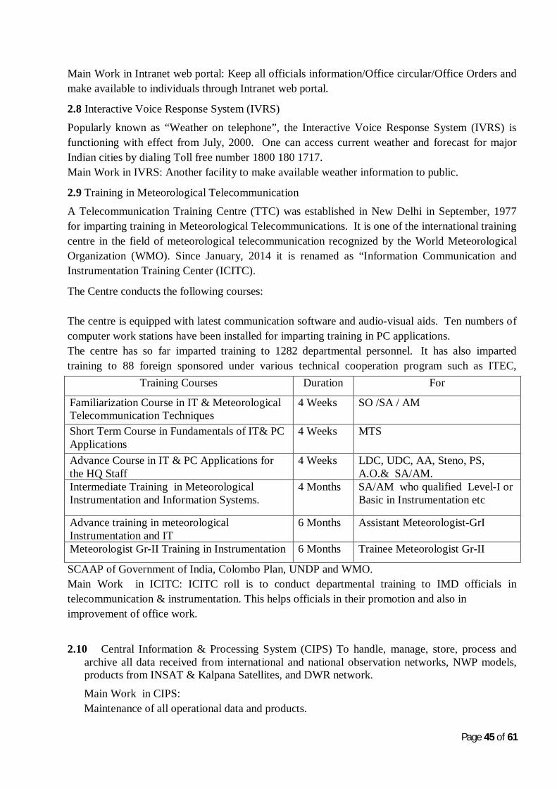
2.9 Training in Meteorological Telecommunication
A Telecommunication Training Centre (TTC) was established in New Delhi in September, 1977 for imparting training in Meteorological Telecommunications. It is one of the international training centre in the field of meteorological telecommunication recognized by the World Meteorological Organization (WMO). Since January, 2014 it is renamed as “Information Communication and Instrumentation Training Center (ICITC).
The Centre conducts the following courses: The centre is equipped with latest communication software and audio-visual aids. Ten numbers of computer work stations have been installed for imparting training in PC applications. The centre has so far imparted training to 1282 departmental personnel. It has also imparted training to 88 foreign sponsored under various technical cooperation program such as ITEC,
SCAAP of Government of India, Colombo Plan, UNDP and WMO. Main Work in ICITC: ICITC roll is to conduct departmental training to IMD officials in telecommunication & instrumentation. This helps officials in their promotion and also in improvement of office work.
2.10 Central Information & Processing System (CIPS) To handle, manage, store, process and archive all data received from international and national observation networks, NWP models, products from INSAT & Kalpana Satellites, and DWR network.
Main Work in CIPS: Maintenance of all operational data and products.
Training Courses Duration For
Familiarization Course in IT & Meteorological Telecommunication Techniques
4 Weeks SO /SA / AM
Short Term Course in Fundamentals of IT& PC Applications
4 Weeks MTS
Advance Course in IT & PC Applications for the HQ Staff
4 Weeks LDC, UDC, AA, Steno, PS, A.O.& SA/AM.
Intermediate Training in Meteorological Instrumentation and Information Systems.
4 Months SA/AM who qualified Level-I or Basic in Instrumentation etc
Advance training in meteorological Instrumentation and IT
6 Months Assistant Meteorologist-GrI
Meteorologist Gr-II Training in Instrumentation 6 Months Trainee Meteorologist Gr-II
Page 46 of 61
Provide the developed products to all synergie forecasting systems. Development of meteorological products as per requirement of forecasters.
2.11 Future Plan
The following up gradation of the existing facilities are under implementation:-
2.11.1 Replacement of Old AMSS at 4 Aerodromes Meteorological Offices Mumbai, Palam, Kolkata and Chennai.
2.11.2 Implementation Mirror GISC for WIS compliant 2.11.3 Proposal for “Setting of LAN at H.Q IMD” with latest state of the art technology. 2.12 Strength of Officers/Staff *
S. No. Name of Post No. of strength Sanctioned Strength 1 Scientist ‘G’ 01 - 2 Scientist ‘F’ 01 - 3 Scientist ‘E’ 02 - 4 Scientist ‘D’ 04 05 5 Scientist ‘C’ 00 04 6 Scientist B 00 12 7 Astt. Meteorologist-I 08 12 8 Astt. Meteorologist-II 18 33 9 Private Secretary 01 -
3. National Satellite Meteorology Division, New Delhi
3. 1 HISTORY
Satellite Meteorology Division started functioning in India Meteorological Department since early 70’s. Since then the division has made a steady progress in satellite data reception and generation of several new products which are quite useful in weather forecasting and the division now plays an important role in supporting weather forecasting.
3.2 INTRODUCTION
Satellite Meteorology Division of India Meteorological Department receives and processes the
meteorological data from the meteorological payloads of INSAT series of satellites namely
Kalpana-1 ,INSAT-3A and INSAT-3D. Kalpana-1 was launched on 12th September, 2002 and is
located at 74°E, INSAT-3A was launched on 10th April, 2003 and is located at 93.5°E and INSAT-
3D was launched on 26th July, 2013 and located at 82 degree east. Kalpana-1 and INSAT-3A both
have three channel Very High Resolution Radiometer (VHRR) for imaging the Earth in Visible
(0.55-0.75 µm), Infra-Red (10.5-12.5µm) and Water vapour (5.7-7.1µm) channels having
resolution of 2X2 kms in visible and 8X8 kms in WV and IR channels. In addition the INSAT-3A
has a three channel Charge Coupled Device (CCD) payload for imaging the earth in Visible (0.62-
0.69µm), Near Infra Red (0.77-0.86µm) and Short Wave Infra Red (1.55-1.77µm) bands of
Spectrum. The Resolution of CCD payload in all the three channels is 1 Km X 1 Km. INSAT-3D
satellite is carrying 6 channel imager for imaging the earth in visible (0.55-0.75um),SWIR (1.55-
1.70um) of resolution 1KmX1 Km, MIR (3.80-4.00um),TIR-1 (10.30-11.30um),TIR-2(11.50-
12.50um) of resolution 4KmX4Km and WV (6.50-7.10um) of resolution 8KmX 8Km. INSAT-3D
also carrying 19 channel sounder consisting of 7 channels of LWIR (14.71-12.02um), 5 channels
of MWIR (11.03-6.51um), 6 channels of SWIR (4.572-3.74um) and one channel of visible
(0.695um) each of resolution 10X10 Km scan the atmosphere for derivation of profiles.
At Present 48 nos. of satellite images are taken daily from INSAT-3D IMAGER & Kalpana-1
VHRR which are the main operational satellite and twenty four images are taken from INSAT-3A
VHRR. Imaging from CCD is done 6 times during daytime only. The INSAT-3D sounder scan is
taken on hourly basis, twenty times of Indian land region and four times of Indian Ocean region for
driving temperature and humidity profiles of these regions.The qualitative products generated after
processing the satellite data are transmitted to users for use in Weather forecasting. In addition to
these all the three satellites are havingData Relay Transponder (DRT) payloads which are being
Page 48 of 61
used to receive and transmit the data from Automatic Weather Stations (AWS)/ Automatic Rain
Gauge (ARG) network from all over India.
3.3 Functions of the Division:
The division has Earth station for the reception of data directly from operational INSAT
series of Geostationary satellites namely Kalpana-1, INSAT-3A and INSAT-3D Data
received from these satellites is processed in INSAT Meteorological Data Processing
(IMDPS) system and generates imageries of all channels and quantitative products such as
Outgoing Long Wave Radiation (OLR), Quantitative Precipitation Estimates namely Hydro
Estimator (HE) INSAT Multispectral Rain fall Algorithm(IMSRA) and GPI/QPE, Sea
Surface Temperature (SST) and Upper Tropospheric Humidity (UTH), night time fog, snow
cover, aerosol optical depth (AOD), fire, smoke, NDVI, temperature and humidity profile,
total ozone layer precipitible water/total precipitable water by using data of kalpana-1,
INSAT-3A and INSAT -3D satellites for use in forecasting / monitoring weather.
The radiance values of Kaplana-1and INSAT-3D are provided to NWP for its assimilation
in NWP model. Wind products are transmitted on GTS in BUFR format. All the imageries
and derived product are disseminated on website on real time basis.
Round the clock surveillance of weather systems including severe weather events around
the Indian region and generating satellite bulletins based on satellite images and products
for use in forecasting.
Detect genesis and growth of tropical cyclones their location and intensity at required
intervals depending upon its severity. Monitor movements of migrating systems such as
tropical cyclones, troughs/ridges, jet streams, region of intense convection, Inter tropical
convergence zone etc.
Various satellite products such as OLR, Wind speed over sea and Water Vapour over sea
etc. are given as an input to weather forecasters and used to decide the onset of monsoon.
All the processed Satellite images & products are archived in National Satellite Data Centre
(NSDC), New Delhi.
The division has a network of 353 cyclone warning dissemination systems (CWDS) for
dissemination of cyclone warning messages to the affected coastal regions of India in their
local languages. The cyclone warning messages are generated by Area Cyclone Warning
Centers. The replacement of all CWDS stations with new technology (DTH-based DWDS) is
Page 49 of 61
in progress. Till date Total 222 DTH based CWDS installed in Tamilnadu, Orissa Andhra
Pradesh and Pondicherry region. Installation work is going on.
NOAA/MODIS/ METOP Satellite data receiving and processing system at New Delhi,
Chennai and Guwahati are used to receive and process the data of NOAA, METOP-A,
Terra, Aqua and FY1 polar orbiting Satellites and derived level-1, level- 2 products and
profiles are made available to forecasters through website for users.
Provide satellite meteorology planning inputs to WMO/CGMS and other National and
International agencies.
3.4Details of Satellite observing systems:
Satellite Meteorology Division receives meteorological data from three Indian satellites namely Kalpana-1, INSAT-3A and INSAT-3D.
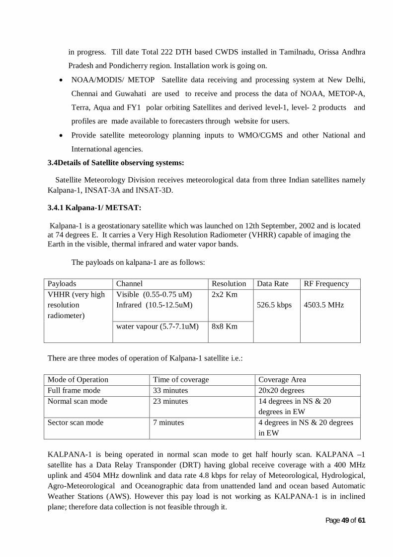
3.4.1 Kalpana-1/ METSAT: Kalpana-1 is a geostationary satellite which was launched on 12th September, 2002 and is located at 74 degrees E. It carries a Very High Resolution Radiometer (VHRR) capable of imaging the Earth in the visible, thermal infrared and water vapor bands.
The payloads on kalpana-1 are as follows:
Payloads Channel Resolution Data Rate RF Frequency VHHR (very high resolution radiometer)
Visible (0.55-0.75 uM) Infrared (10.5-12.5uM)
2x2 Km 526.5 kbps
4503.5 MHz
water vapour (5.7-7.1uM)
8x8 Km
There are three modes of operation of Kalpana-1 satellite i.e.:
Mode of Operation Time of coverage Coverage Area Full frame mode 33 minutes 20x20 degrees Normal scan mode 23 minutes 14 degrees in NS & 20
degrees in EW Sector scan mode 7 minutes 4 degrees in NS & 20 degrees
in EW
KALPANA-1 is being operated in normal scan mode to get half hourly scan. KALPANA –1 satellite has a Data Relay Transponder (DRT) having global receive coverage with a 400 MHz uplink and 4504 MHz downlink and data rate 4.8 kbps for relay of Meteorological, Hydrological, Agro-Meteorological and Oceanographic data from unattended land and ocean based Automatic Weather Stations (AWS). However this pay load is not working as KALPANA-1 is in inclined plane; therefore data collection is not feasible through it.
Page 50 of 61
3.4.2 INSAT-3A : INSAT-3A is a geostationary satellite which was launched in April 2003. It is located at 93.5degree east longitude in the geostationary orbit. INSAT-3A is the third satellite in the INSAT-3 series. INSAT-3B and INSAT-3C were launched in March 2000 and January 2002 respectively. INSAT-3A is a multipurpose satellite for providing telecommunications, television broadcasting, meteorological and search & rescue services The metrological payloads on INSAT-3A are as follows: Payloads Channel Resolution Data Rate Frequency VHHR (very high resolution radiometer)
visible (0.55-0.75 um)
2x2 Km 526.5 kbps
4501.5 MHz
infrared (10.5-12.5 um) water vapour (5.7-7.1 m)
8x8 Km
Charge Coupled Device Camera(CCD)
Visible (0.62-0.68 um)
1x1 Km
1.28875 Mbps
4508.9 MHz
NIR (0.77-0.86 um) SWIR (1.55-1.69 um)
There are three modes of operation of INSAT-3A satellite for VHRR payload: Mode of Operation Time of coverage Coverage Area Full frame mode 33 minutes 20x20 degrees Normal scan mode 23 minutes 14 degrees in NS & 20
degrees in EW Sector scan mode 7 minutes 4 degrees in NS & 20 degrees
in EW There are two modes of operation of INSAT-3A satellite for CCD payload: Mode of Operation
Time of coverage Coverage Area
Normal frame mode 25 minutes 10 X10 deg Program mode Programmable Programmable
The communication payloads on INAST-3A are as follows: A Data Relay Transponder (DRT) operating in UHF band (400 MHz) uplink for real-time Hydrological, Agro-Meteorological and Oceanographic data collection from unattended platforms located on land and river basins based Automatic Weather Stations (AWS). The data is then relayed in extended C-band (4506.05 MHz) downlink to a central location at Pune and Delhi It also have onboard 12 nos C-band transponders, nine of which have expanded coverage providing an Edge-of-Coverage (EoC) Effective Isotropic Radiated Power (EIRP) of 38 dBW and three having India beam coverage providing an EoC-EIRP of 37 dBW 6 upper extended C-band transponders having India beam coverage providing an EoC-EIRP of 37 dBW.It also has onboard 6
Page 51 of 61
Ku-band transponders having India beam coverage providing an EoC-EIRP of 47.5 dBW and Satellite Aided Search & Rescue (SAS&R) transponder. 3.4.3 INSAT-3D: India launched an exclusive meteorological satellite on 26th July, 2013 from French, Guyana using ARIANE rocket. It is located at 82 Degrees East and have followingobjectives:
• To monitor earth’s surface, carryout oceanic observations and its environment in various spectral channels of meteorological importance.
• To provide the vertical profile of temperature and humidity parameters of the atmosphere. • To provide the data collection and data dissemination capabilities from the Data Collection
platforms (DCPs). • To provide the satellite aided search and rescue services.
The metrological payloads on INSAT-3D are as follows: Payloads Channel Resolution Data Rate Frequency Imager visible (0.52-0.77 um) 1x1 Km
3.92725 Mbps
4781 MHz SWIR (1.55-1.70 um ) 1x1 Km
MIR (3.8-4.0 um ) 4x4 Km WV (6.5-7.1 um ) 8x8 Km TIR-1 (10.3-11.3 um) 4x4 Km TIR-2 (11.5-12.5 um) 4x4Km
Sounder LWIR -7 channel (14.71-12.02 um) 10x10 Km
40.00 Kbps
4798 MHz MWIR-5 Channel (11.03-6.51 um)
SWIR-6 Channel (4.57-3.74 um) VIS (0.695 um)
DRT Up link 402.75MHz 4506.05MHz S&SR Up link 406.05MHz 4507 MHz
There are three modes of operation of INSAT-3D satellite for Imager: Mode of Operation Time of coverage Coverage Area Full frame mode 26 minutes 18x18 degrees Programmed Normal scan mode
23 minutes 14x18degrees
Programmed Sector scan mode
6 minutes 4 degrees in NS & 18 degrees in EW
At present INSAT-3D imager is being operated in full frame mode to get half hourly images. INSAT-3D carries a newly developed 19 channel sounder, which is the first such payload to be flown on an ISRO satellite mission. The Sounder has eighteen narrow spectral channels in shortwave infrared, middle infrared and long wave infrared regions and one channel in the visible region. The ground resolution at nadir is nominally 10x10km for all nineteen channels.INSAT-3D adds a new dimension to weather monitoring through its Atmospheric Sounding System, with
Page 52 of 61
vertical profiles of temperature 40 levels (surface to 70 km) Humidity 21 levels (surface to 15 km) and integrated ozone from surface to top of the atmosphere These profiles are available for a selected region over Indian landmass every one hour and for the entire Indian Ocean Region every sixth hours
Products to be derived from INSAT-3D:
1. Imagery in all channels 2. Temperature Profile 3. Humidity Profile 4. Atmospheric Motion Vector (AMV) Winds(CMV,WVW & VISW) 5. Sea Surface Temperature 6. Quantitative Precipitation Estimate (QPE)- GPI 7. QPE (IMSRA) 8. Upper Tropospheric Humidity (UTH) 9. Outgoing Long range Radiation (OLR) 10. Cloud Mask 11. Fog 12. Aerosol Optical Thickness 13. Active Fires 14. Smoke 15. Snow Cover 16. Land Surface Temperature 17. Insolation
3.5 Earth Station: Earth station has a capability to receive the data from KALPANA-1 VHRR, INSAT-3A VHRR, CCD, INSAT-3D Imager, Sounder and AWS/ARG through a disc antenna installed for each satellite. Demodulation of data is carried out and the data extracted from RF signal is further sent to the IMDPS unit for processing. Round the clock monitoring of data reception and routine maintenance is carried out for uninterrupted data reception.
Page 53 of 61
3.6 INSAT Meteorological Data Processing System
The data received from Earth station is processed in INSAT-3D Meteorological Data Processing System (IMDPS) unit on round the clock basis and generate half hourly cloud imagery of Kalpana-1 and three hourly from INSAT-3A satellite in real time. The system generates automatically the images in desired area and geo-physical parameters like Cloud Motion Vector (CMV), Water Vapour Wind (WVW), Outgoing Long Wave Radiation (OLR), Quantitative Precipitation Estimate (QPE), Sea Surface Temperature (SST) and Upper Tropospheric Humidity (UTH) using all half hourly images of kalpana-1. The CCD payload of Insat-3A gives high resolution images in three channels; VISIBLE, NIR & SWIR. The processing system processes these data and generates images and few products like Vegetation Index (NDVI) and Aerosol Optical Depth (AOD). These images and products are made available on the website for different users. All images and products in digital & image formats are archived and stored for future use. The INSAT-3A is also used to receive data from Automatic Weather Stations (AWS) installed at different locations in India. The operational officers/staff monitor the image quality and products before transferring to the users. They also generate some value added products like Cloud Top Temperatures etc., and update on the website. This unit is also responsible for the supply of data to users. Requests for the data are processed and after fulfilling the formalities as per the Data Supply Policy, the data is supplied to the users. This unit generates a Monthly operational report at the end of each month on the activities and performance of the IMDPS system as a whole and this report is distributed to different organizations.
3.7 Software Unit
The software unit works with full coordination of IMDPS operational unit. This unit maintains the entire software of IMDPS and makes necessary modifications to meet the requirements of different sections/ units as well as other users of different Institutes/ Organizations. In addition to these following tasks are also carried out by the software group.
1. Archival of data on CD/DVD as a backup.
2. Validation of products like AMV, OLR, QPE on monthly basis.
3. Extraction of data from DLT and archival on CD/DVD for easy accessing of the historical data.
4. Monitoring of websites and introduction of new parameters whenever required.
5. Monitoring of data transfer to Transmet for the onward transmission to CIPS.
6. Providing necessary feedback to SAC/ISRO for the improvements in the quality of the products and generation of new products.
3.8 Synoptic Application Unit
Interpretation of satellite imageries and issuing satellite bulletins based on three hourly INSAT cloud imageries and products ,NOAA, METOP and MODIS imageries and level-2 products, GPS derived IPWV is done by the division. The Satellite bulletins are prepared and transmitted to all the
Page 54 of 61
forecasting offices on Global Telecom Service through RTH New Delhi and also uploaded on IMD Website. Special hourly satellite bulletins in case of cyclone over Bay of Bengal or Arabian sea, Heavy rainfall advisories bulletins, plain language inference for Amaranth Yatra/VVIP flights and TV News daily at 0500 and 0600 UTC, cloud estimation over India daily at 0500UTC and estimation of snow cover over western Himalayan region, analysis/validation of tropical cyclone over Indian region are prepared and transmitted on GTS and website.
3.9. Global Positioning System (GPS) computed Integrated Precipitable Water Vapourmeasuremen( IPWV): Moisture in atmosphere is the main source of all weather related phenomenon. Water content is measured conventionally by upper air soundings and estimated through satellite by Upper Tropospheric Humidity (UTH),Integrated Precipitable Water Vapour measurement which depicts the integrated amount of water vapour vertically over a place is fast being recognized as an important tool for weather forecasting and is being used extensively worldwide. As a pilot project five no’s GPS stations were installed at New Delhi, Mumbai, Chennai, Kolkata and Guwahati on 4th April 2007. Data are collected at New Delhi from all the five stations at every half hour & processed for integrated precipitable water vapour.
The output is made available on IMD website both in graphical as well as Tabular form. The
website gets updated every half hour automatically without any user intervention. Initial response to
this measurement technique is good and can be used as important input to forecast thunderstorm
activity. Accuracy of IPWV measurement is 5 mm.
The installation of 25 no’s more GPS Stations for IPWV is under progress..
3.10. National Satellite Data Center National Satellite Data Center (NSDC) at IMD New Delhi archives and provides processed imagery data from various INSAT satellites and data of derived products in HDF5 format. The vision of the Centre is to archive all types of Satellite data and derived products generated in the Satellite meteorology division and supply the same as per user requirement vis-à-vis- time/space/satellite/product/image on line and as fast as possible. The Centre started its operations by mid 2005. The data available are satellite imageries and products from Geostationary Indian National Satellites (INSAT) in operation from time to time and having Meteorological payloads. The archival contains new and old data from 1984 onwards and is likely to grow with time with the launch of new satellite like INSAT 3D and archival of satellite data from NOAA/METOPs/MODIS satellites. RFP for up gradation of NSDC to a state of art New Satellite Data Centre is in final stage. It will be floated in 2016-17.
3.11. Cyclone Warning Dissemination Systems (CWDS)
Total 248 DTH based CWDS installed in Tamilnadu, Orissa, Andhra Pradesh and Pondicherry region. Installation work is going on for other stations
Page 55 of 61
3.12 NOAA/MODIS/ METOP Polar Orbiting Satellite data receiving and processing system
NOAA/MODIS/ METOP Satellite data receiving and processing system at New Delhi, Chennai and Guwahati are used to receive and process the data of NOAA, METOP-A, Terra, Aqua and FY1 polar orbit Satellites and derived level-1, level- 2 products and profiles are made available to forecasters through website for users. The APT images of NOAA satellites are also received and displayed on IMD website.
Metop Satellite data receiving & processing systems enhance the capability of weather forecasts by direct interpretation of images as well as by giving input to NWP models. Similarly NOAA/MODIS data is very useful in day to day weather forecasting and input to NWP models as they provide the vertical profile of temperature and humidity in addition to imagery in various channels. The profiles and products are generated and disseminated through website for the use of forecasters on real time basis and validation of various products is in progress.
The list of derived products from L-Band (NOAA-N and Metop-A) and X-Band TERRA and AQUA(MODIS) is given below:
S.No. L-Band(NOAA,Metop) X-BAND(MODIS)
1 Temperature profile(ATOVS) Temperature profile (MOD07);
11 Land-surface temperature (from AVHRR MODIS true colour
12 Cloud fraction (from ATOVS Vegetation index (MOD13);
13 Fire points (from AVHRR) Thermal anomalies (MOD14
14 Chlorophyll concentration (MOD18)
15 Sea-surface temperature (MOD28).
3.14. Technical Coordination Unit (TCU)
TCU coordinates all projects implementation in satellite division and provide technical brief/standard brief and other information for all meeting with ISRO/WMO to senior officers.
3.15.Hardware Unit
The routine maintenance of all the systems and award of AMCs of different systems and coordination with other agencies is undertaken by Hardware Unit (H/W) including procurement of stores.
3.16.Future satellites:
1. It is planned to launch the INSAT-3DR, INSAT-3DS and Geo Imaging Satellites (GISAT) during the year 2016-2017 to maintain the continuity and to adopt the advancement of technology in the satellite field. GISAT will carry Multi-spectral, multi-resolution imager payloads (High resolution multi-spectral VNIR (HRMX-VNIR) of six band of 50 m resolution, Hyper spectral VNIR of 60 bands of 320 m resolution, Hyper spectral SWIR (HyS-SWIR) of 150 bands of 192 m resolution and High resolution Multi-spectral (HRMX-TIR) of six band of 1.5 km resolution) leading to new era of satellite meteorology in India.
Page 57 of 61
2. SCATSAT-1 is planned as an in-orbit replacement for the Scatterometer carried onboard Oceansat-2, It will be launched by the end of 2016 at an altitude of 720 Kms with an objective to provide global sea wind vector data to national and international user Community.
3.
3.17. Organization ORGANISATIONAL CHART (Present)
Satellite Meteorology Division,O/O of DGM, New Delhi
Duties and responsibilities of Officers of Sat Met Division
A. Class-I Supervisory Cadre
Scientist-G/F/E/D
Scientist-G/F is head of division and overall responsible for running the division and planning of various projects /activities and supervising the implementation of projects. He also attend policy related meeting at various levels and ensure the availability all deliverable to different divisions/agencies. Scientist-F/E/D is a supervisor cadre and responsible for overallthe operational activities of different sections of the division. They also coordinate with the MCFHassan and Space Application Centre and other stake holder of Satellite Meteorology for the technical and planning issues. They are also involved in improvement, refinement, validation and research on various satellite derived products. They impart training in satellite meteorology to departmental trainees; Air Force/Navy met personnel’s and guides the B.Tech/ M.Tech students of various institutions deputed for summer internship programmes.
Scientist-C/B
They are responsible for executing all work assigned by the supervisory cadre for sustaining operational activities/ maintenance and research activities of the division. They are also involved in data archival of Monitoring and supervising the quality of the products on daily basis. Maintaining the data acquisition, processing and web based dissemination systems. They are also responsible for the overall supervision, maintenance of the Satellite data reception software installed on different system in IMDPS and implementation of any modifications and updates in the software. Liaison with different institutions regarding their satellite data requirements. Liaison with manufacturesregarding implementation of new algorithms.Responsible for maintaining the backups of the systems, conducting the weekly recoveries on the systems. They also attend the day to day problems of the systems and monitoring quality of different Geo-Physical parameters derived from the satelliteand their validation. Interacting with differentinstitutions regarding their satellite data requirements and providing easy interpretation of INSAT data.Monitoring the performance of DTH based DCWDS system installed at field stations. Correspondence with Wireless planning commission (WPC) for license.
B. Class-II Supervisory Cadre
Assistant Meteorologist grade-I and Grade-II
They are looking after the administrative work inthe variousunit of the division. They are also involved in generating and monitoring various Geo-Physical parameters, their archival/retrieval/ and supervising operational activities round the clock to sustain the availability of deliverable on operational basis.
Coordinate all projects implementation in Satellite division Provide Technical Brief/ standard brief and other information for all meeting with ISRO/WMO etc. to all senior officers.
Involved in interpretation of satellite imageries and issuing the Satellite bulletins based on 3 hourly/1 hourly/ 1/2 hourly INSAT cloud imageries and products are prepared and transmitted to all the forecasting offices on Global Telecom Service GTS through RTH New Delhi.
Page 59 of 61
Special hourly satellite bulletin in case of cyclone over Bay of Bengal or Arabian Sea. Heavy r/f advisory bulletins are also transmitted regularly and special convective/thunder activity bulletin in pre monsoon period. Plain language inference for Amaranth Yatra/ for VVIP flights and for TV News daily at 0500 and 0600 UTC. Cloud estimation over India daily at 0500 UTC and estimation of snow cover over Western Himalayan region. Imparting organizing training to different national/ international trainees on use of satellite imageries in weather forecasting and Involved in different scientific projects. uploading 3 hourly/ Hourly detailed satellite bulletins on IMD Website. Maintaining of all records related to indent and Purchase concerning Sat Met Div. Sanction regarding making payment of freight/insurance/custom duty/final clearance of clearing agentAwarding of Annual Maintenance Contract of instruments installed in Sat Met Div. Preparation of tender documents & Processing (Opening of technical and financial bids)Quarterly payment of all awarded AMCs.
Maintenance of all records and registers relating to store materials of Sat Met Division.Issue & receipt of all consumables and non-consumable items of Sat Met Division.Coordination of Physical verification of store on annual basis.Intimation of monthly status of different items of store to the concern authority. Monitoring and Supervision of general branch work .Responsible for preparation of Action taken report on minutes of meeting and sanction letter for making all payments.Implementation of official language , correspondence with Budget & Planning Section, Reply to audit queries. Procurement of equipments / consumable for smooth functioning of operational work. Co-ordination with CPWD for maintenance of UPS/AC etc.Liasoning with extra departmental agencies for maintenance of equipments.Monitoring of AMCs pertaining to IMDPS equipments.
C. Supporting Staff
Scientific Assistant
Involved in downloading the data from international satellites like, Meteosat, SSM/I etc., and providing it to various users in IMD in a pictorial form that can be easily interpreted. They are responsible for maintaining the archival of imagery and products data and make them available for distribution.
They generate the special products like, CMV, WVW, daily OLR, QPE, and SST from different systems and send to NHAC and Synoptic units. . They are also involved in archival hdf data on CD/DVD. Additional requirements of images and products will also be generated and supplied to the users.
They will generate hourly images with District boundaries and exports to website after checking the image quality. They will also generate images on special occasions like VVIP flights, Amarnathji Yatra etc. and upload to the website and archival.
Requisition and supply of stationary items from HQ to various sections of Sat. Met., Telephone bills, Newspaperbills etc. Matters related to gazetted and non-gazetted staff Correspondence of all matters related to staff/ officers of Sat. Met. Division. Correspondence with Budget section, planning section vigilance cell RTI cell, Works study cell. All the files concerning to Symposium, Seminars, Sagar Kanya, Junior Research fellow posted in Sat. Met. Division Preparation of Monthly/ Quarterly progress report.
Page 60 of 61
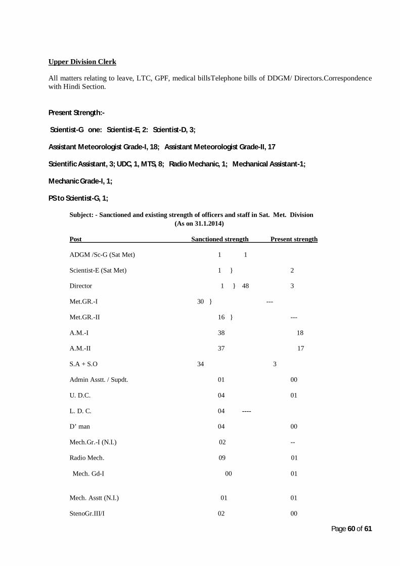
Upper Division Clerk
All matters relating to leave, LTC, GPF, medical billsTelephone bills of DDGM/ Directors.Correspondence with Hindi Section.