29
MISSION BASUNDHARA

MISSION
BASUNDHARA
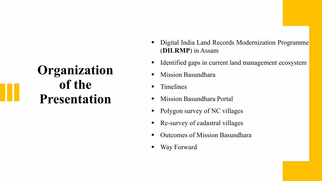
Organization of the
Presentation
Digital India Land Records Modernization Programme
(DILRMP) in Assam
Identified gaps in current land management ecosystem
Mission Basundhara
Timelines
Mission Basundhara Portal
Polygon survey of NC villages
Re-survey of cadastral villages
Outcomes of Mission Basundhara
Way Forward

Digital India Land Records Modernization
Programme
(DILRMP)
94% RoRs computerized under Computerization of Land Records
98% cadastral maps have been digitized under Digitization of Cadastral Maps/FMBs
100% computerization of SROs and their integration with RoR
Automated transfer of information for mutation
Assessment of stamp duty and registration fees, obtaining registered document on the same day of registration, slot booking, biometric inputs are features of e-Panjeeyan (registration software)
Work in progress for providing interconnectivity through BSNL at 23 locations (SROs, COs & JDS) and augmentation of bandwidth from 2 mbps to 10 mbps across revenue circles
Work in progress for preparation of Modern Record Rooms in 21 locations and to be completed by end of November 2021
ULPIN (Unique Land Parcel Identification Number), project has been successfully launched on pilot basis in Bongaigaon district in June 2021

Identified gaps in current land management ecosystem Weak jurisdiction on land matters in sixth schedule districts - lags in digitization
of land records
672 NC villages yet to be surveyed and 1251 missing/damaged maps of 1122 villages requiring re - survey
Ongoing re-settlement operations in five (5) Districts covering eighteen (18) revenue circles - challenges in bringing them online to Dharitree (Land Records) portal
Pendency in updation of land records/maps and issues in partition of joint estates
Digitization of manual system of land records in place of true digitalization
Integration pains due to stand alone development of IT systems for RoR, Registration and Maps
Weak connectivity and erratic electricity in fringe areas
To meet the existing gaps, Mission Basundhara conceptualized and launched
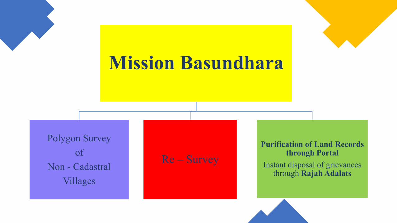
Mission Basundhara
Polygon Survey
of
Non - Cadastral
Villages
Re – Survey
Purification of Land Records through Portal
Instant disposal of grievances through Rajah Adalats

Polygon Survey
of
Non - Cadastral
villages
October 2, 2021
to
March 31, 2022
100 %
Digitalization and
Integration of
Textual and Spatial
Records for Assam
as mandated under
DILRMP Re - Survey
of
Cadastral Villages
To be completed by
December 31, 2023
Purification of
Land Records in
Mission
Mode by disposal
of cases received
Applications
through portal by
citizens from
October 2 –
November 30, 2021
Disposal by May
10, 2022
Portal for Nine
Land Revenue
Services
&
Rajah Adalats
Timelines
Mission Basundhara
Portal
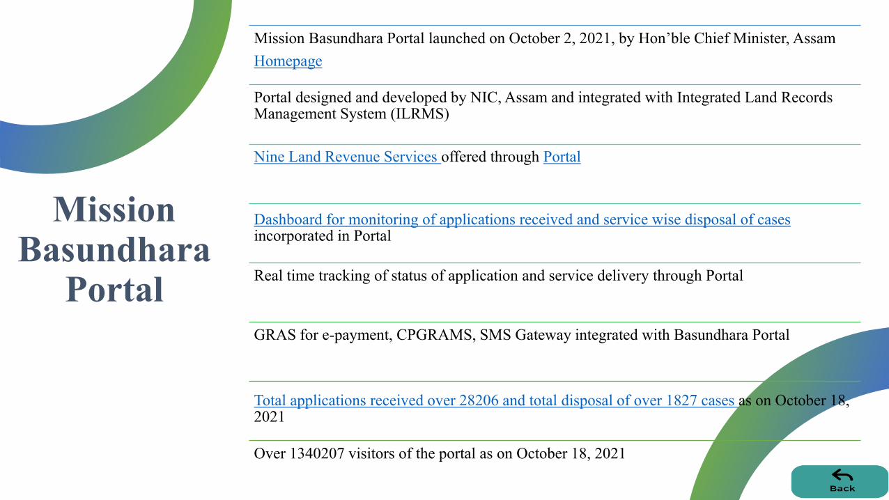
Mission Basundhara Portal launched on October 2, 2021, by Hon’ble Chief Minister, Assam
Homepage
Portal designed and developed by NIC, Assam and integrated with Integrated Land Records Management System (ILRMS)
Nine Land Revenue Services offered through Portal
Dashboard for monitoring of applications received and service wise disposal of cases incorporated in Portal
Real time tracking of status of application and service delivery through Portal
GRAS for e-payment, CPGRAMS, SMS Gateway integrated with Basundhara Portal
Total applications received over 28206 and total disposal of over 1827 cases as on October 18, 2021
Over 1340207 visitors of the portal as on October 18, 2021
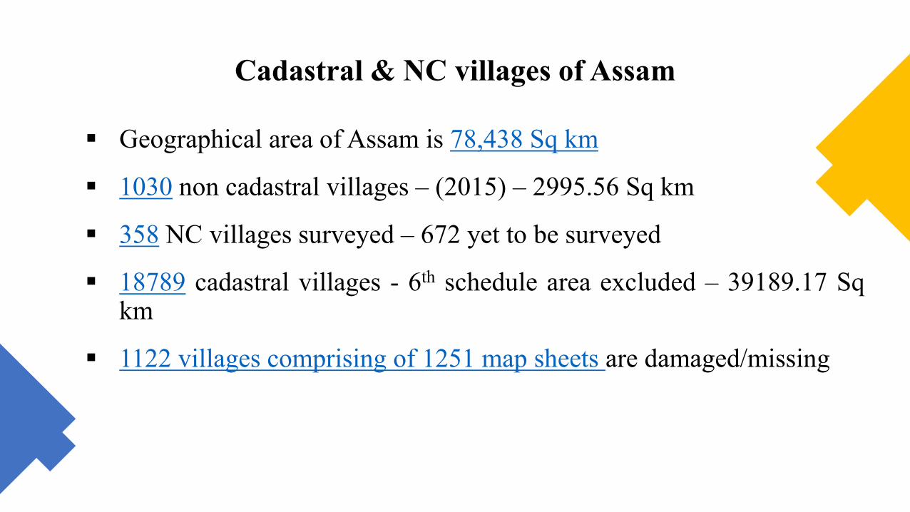
Cadastral & NC villages of Assam
Geographical area of Assam is 78,438 Sq km
1030 non cadastral villages – (2015) – 2995.56 Sq km
358 NC villages surveyed – 672 yet to be surveyed
18789 cadastral villages - 6th schedule area excluded – 39189.17 Sq km
1122 villages comprising of 1251 map sheets are damaged/missing
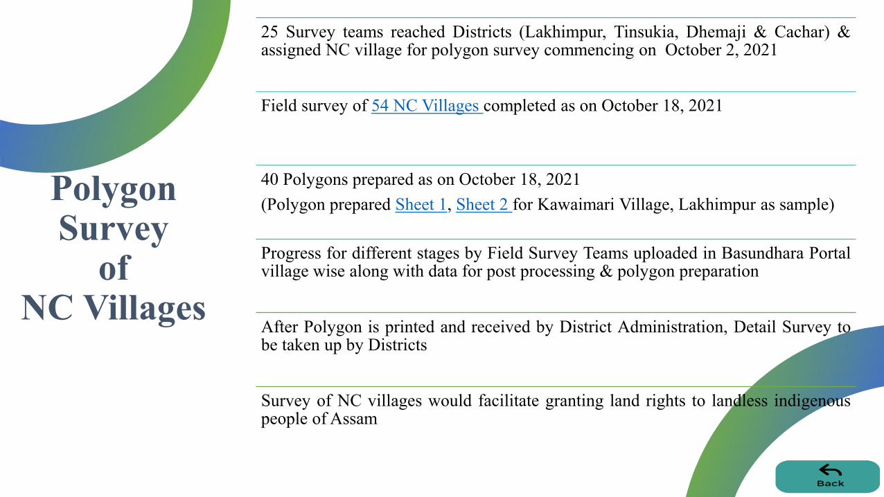
Polygon Survey
of NC Villages
25 Survey teams reached Districts (Lakhimpur, Tinsukia, Dhemaji & Cachar) & assigned NC village for polygon survey commencing on October 2, 2021
Field survey of 54 NC Villages completed as on October 18, 2021
40 Polygons prepared as on October 18, 2021
(Polygon prepared Sheet 1, Sheet 2 for Kawaimari Village, Lakhimpur as sample)
Progress for different stages by Field Survey Teams uploaded in Basundhara Portal village wise along with data for post processing & polygon preparation
After Polygon is printed and received by District Administration, Detail Survey to be taken up by Districts
Survey of NC villages would facilitate granting land rights to landless indigenous people of Assam

Timeline followed for field survey of an NC village
Camp relocation - initial establishment (1 day), shifting to
be done if necessary
Field reconnaissance
= 1 day
Pillar erection
= 2 days
Field Observation
= 2 days
Data Downloading and post Processing
and uploading
=1 day

Re-Survey of
Cadastral Villages
RFP floated for Survey/Resurvey of cadastral villages of Assam where maps are not available or permanently damaged
On a pilot basis, reconstruction of the missing/damaged maps of Dibrugarh, Tinsukia and Kamrup by hybrid methodology to be completed by December 31, 2021
Followed by Re-survey of 18789 cadastral villages of 27 Districts with hybrid methodology to be completed by December 31, 2023
Final data to be uploaded in Bhunaksha and for integration with RoR (True Digitalization of land records)
Will pave way towards clear land titles in Assam

Cadastral Villages Re-survey by hybrid methodology
Marking GCP
(2days)
Drone Flying
(1 Day)
Processing of data capture &
Mosaicing
(2 days)
Img 1, 2, 3
Printing of imagery + digitized cadastral
maps
(1 day)
Ground truthing
(15 days)
Digitization/feature extraction of updated
parcels
(7 days)
Meta data preparation
(2 days)
Uploading final data in Bhunaksha and
Integration with RoR

Outcomes of Mission Basundhara
Citizen Centric Portal for availing land revenue services and delivery online in place
Automation of services has reduced the visits by citizens to revenue and registration offices
Mission Basundhara Portal facilitating ease of living, ease of doing business and process transparency
Massive sensitization of citizens regarding availing land revenue services through transparent online interface and facilitation of digital literacy
The mission mode updation/purification of land records shall enable creating updated land records free from encumbrances
The Survey and Re-Survey shall enable granting land rights to indigenous people and lead to accurate and assured land parcels

Way Forward
NGDRS and ULPIN mainstreaming
Revamping survey architecture (manpower & infrastructure) for continuous updation of maps
To bring the Districts under ongoing Resettlement Operation into the ambit of Dharitree
A legislation to facilitate providing of authentic land parcel
Improving user experience and interface of ILRMS, technological innovations - based land reforms
Aadhaar seeding of land records
Single sign on and single payment for integrated services

THANK YOU
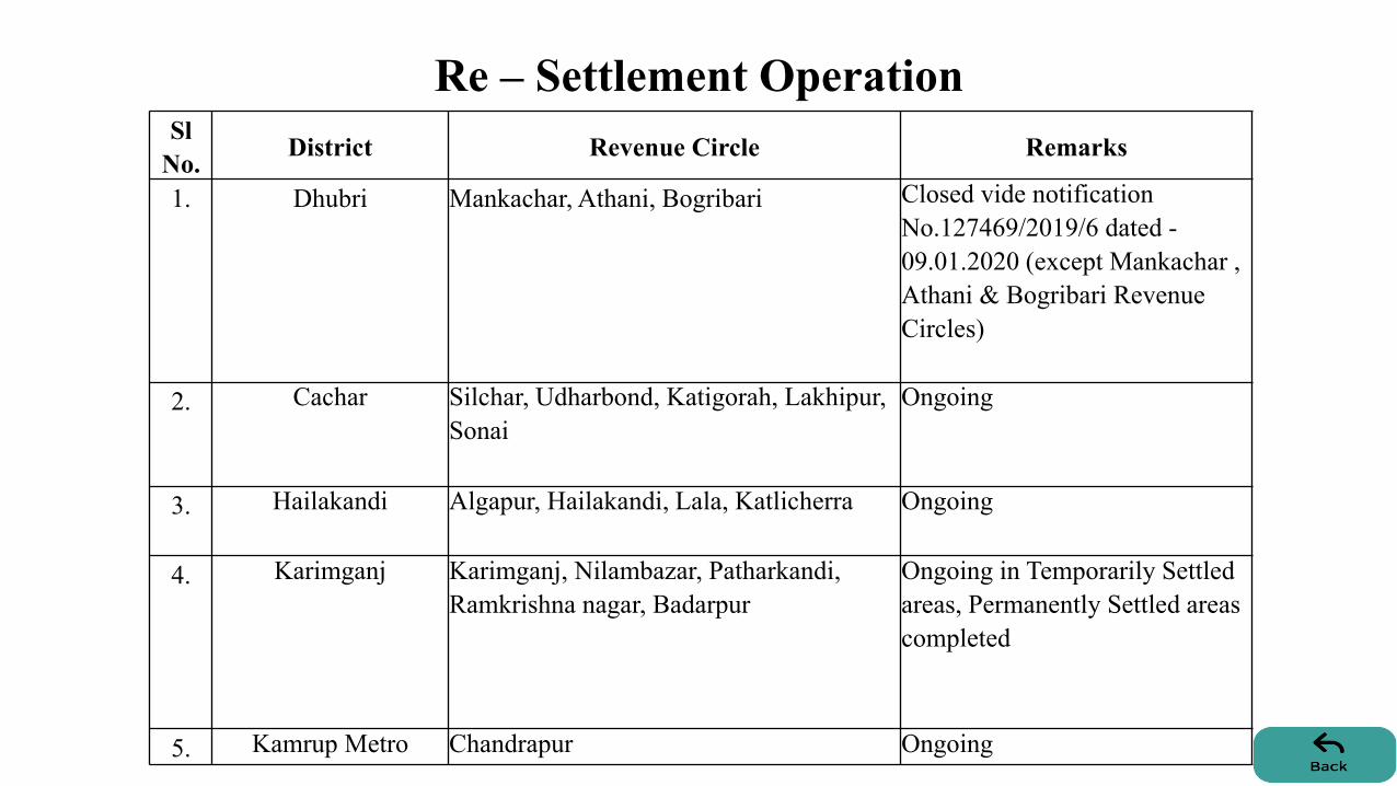
Re – Settlement Operation Sl
No. District Revenue Circle Remarks
1. Dhubri Mankachar, Athani, Bogribari Closed vide notification
No.127469/2019/6 dated -
09.01.2020 (except Mankachar ,
Athani & Bogribari Revenue
Circles)
2. Cachar Silchar, Udharbond, Katigorah, Lakhipur,
Sonai
Ongoing
3. Hailakandi Algapur, Hailakandi, Lala, Katlicherra Ongoing
4. Karimganj Karimganj, Nilambazar, Patharkandi,
Ramkrishna nagar, Badarpur
Ongoing in Temporarily Settled
areas, Permanently Settled areas
completed
5. Kamrup Metro Chandrapur Ongoing

Services of Basundhara Portal
Mutation by right
of inheritance
Partition for
undisputed cases
Conversion from AP
to PP (non-
transferred cases)
Striking names of
persons no longer in
possession from
RoR under Rule
116, ALRR 1886
Mutation after
deed registration
Reclassification of
Land
Updation of
contact number of
pattadar
Legacy Data
Rectification/
Updation
Allotment
Certificates to PP


12685
39189
2295
14147
10122
Geographical Area of Assam
Forest
Cadastral Village
NC Village
Forest 6th Schedule
Village Area 6th Schedule

Sl No District Total No. of Villages Area in Sq Km
1 Barpeta 50 395.84
2 Biswanath 8 7.06
3 Bongaigaon 10 2.65
4 Cachar 81 37.82
5 Charaideo 1 1.34
6 Darrang 33 314.59
7 Dhemaji 202 373.70
8 Dhubri 7 14.96
9 Dibrugarh 32 13.68
10 Goalpara 9 44.86
11 Golaghat 14 17.03
12 Hailakandi 18 25.24
13 Hojai 9 39.02
14 Jorhat 14 38.44
15 Kamrup Metro 84 118.24
16 Kamrup 76 86.66
17 Karimganj 15 14.34
18 Lakhimpur 184 380.50
19 Majuli 32 78.44
20 Morigaon 1 0.060
21 Nagaon 19 24.52
22 Nalbari 2 7.29
23 Sibsagar 20 59.55
24 Sonitpur 2 2.38
25 South Salmara-Mankachar 21 46.31
26 Tinsukia 86 151.04
Total 1030 2295.56
List of NC villages
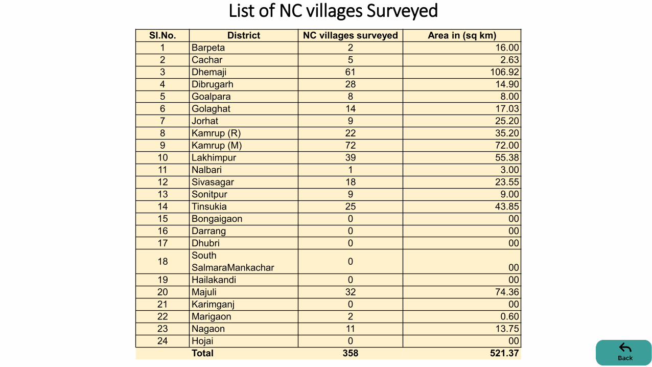
SI.No. District NC villages surveyed Area in (sq km)
1 Barpeta 2 16.00
2 Cachar 5 2.63
3 Dhemaji 61 106.92
4 Dibrugarh 28 14.90
5 Goalpara 8 8.00
6 Golaghat 14 17.03
7 Jorhat 9 25.20
8 Kamrup (R) 22 35.20
9 Kamrup (M) 72 72.00
10 Lakhimpur 39 55.38
11 Nalbari 1 3.00
12 Sivasagar 18 23.55
13 Sonitpur 9 9.00
14 Tinsukia 25 43.85
15 Bongaigaon 0 00
16 Darrang 0 00
17 Dhubri 0 00
18 South
SalmaraMankachar 0
00
19 Hailakandi 0 00
20 Majuli 32 74.36
21 Karimganj 0 00
22 Marigaon 2 0.60
23 Nagaon 11 13.75
24 Hojai 0 00
Total 358 521.37
List of NC villages Surveyed

Sl No District Total No. of Villages Area in Sq Km
1 Barpeta 943 2297.56
2 Biswanath 868 1395.93
3 Bongaigaon 446 737.40
4 Cachar 949 2646.70
5 Charaideo 351 929.08
6 Darrang 622 1208.33
7 Dhemaji 1079 1519.41
8 Dhubri 971 1733.69
9 Dibrugarh 1384 2345.83
10 Goalpara 809 1768.75
11 Golaghat 633 1875.94
12 Hailakandi 307 1329.00
13 Hojai 374 891.34
14 Jorhat 663 1680.12
15 Kamrup Metro 325 652.77
16 Kamrup 1036 2295.07
17 Karimganj 739 1591.83
18 Lakhimpur 1149 1819.88
19 Majuli 190 482.29
20 Morigaon 633 1406.77
21 Nagaon 1016 2187.71
22 Nalbari 520 1033.91
23 Sibsagar 558 1387.99
24 Sonitpur 1005 1852.21
25 South Salmara -Mankachar 37 84.12
26 Tinsukia 1182 2035.54
Total 18789 39189.17

Damaged/missing maps
Sl.No. Name of District Revenue Villages Map Sheets Area
(Sq km)
1 Barpeta 227 256 473
2 Baksa 6 6 13
3 Dibrugarh 638 701 1331
4 Kamrup (M) 2 2 4
5 Kamrup 96 114 200
6 Nalbari 17 18 35
7 Tinsukia 136 154 284
Total 1122 1251 2340


Field Survey of
54 NC villages under
Mission Basundhara
Sl.No. District
Circle
Status of NC Village Survey
Field Survey as on Oct 18, 2021
Completed
1
Cachar
Cachar 1
Katigorah 2
Lakhipur 2
Sonai 1
Udharbond 1
2 Dhemaji Jonai 9
Sissiborgaon 8
Gogamukh 2
Dhemaji 4
3 Tinsukia Margherita 4
Sadia 2
4 Lakhimpur Narayanpur 2
Bihpuria 2
North Lakhimpur 3
Dhakuwakhana 5
Subansiri 1
Kadam 5


