20
MKDP Outline Pre-Application Walnut Tree, Highgate Over www.milton-keynes.gov.uk/ udla Urban Design & Landscape Architecture July 2014
MKDP Outline Pre-ApplicationWalnut Tree, Highgate Over
www.milton-keynes.gov.uk/udla
Urban Design & Landscape Architecture
July 2014

Highgate Over, Walnut Tree
2
This document has been prepared by Milton Keynes Council’s Urban Design and Landscape Architecture Team. For further information please contact:
Neil Sainsbury, Head of Urban Design and Landscape Architecture
Urban Design and Landscape ArchitecturePlanning and TransportMilton Keynes CouncilPO Box 113, Civic Offices1 Saxon Gate EastMilton Keynes, MK9 3HN
T +44 (0) 1908 254766E [email protected]
Produced in association with

Urban Design & Landscape Architecture
www.milton-keynes.gov.uk/udla 3
SECTION 1 INTRODUCTION
1.0 Site Location and Context pg 5
1.1 Site Boundary pg 6
1.2 Site Photos pg 7
SECTION 2 THE SITE & OPTIONS 2.0 Access pg 9
2.1 Proposed Uses pg 9
2.2 Key Principles pg 9
2.3 Parameters Plan Options pg 9
2.4 Option 1 pg 10
2.5 Option 2 pg 11
2.5 Option 2 pg 12
Contents
Outline and purpose of the Document
The purpose of this document is to establish the broad planning and design parameters for development of this site in line with the existing land use allocation and as per existing policy. The intention is that this document will provide a degree of clarity for a developer when preparing a planning application.
At the outset views were sought from the Parish Council and Local Ward Members and where appropriate their comments were addressed in the outline pre-application document.
This process ensures MKDP meet their obligation to obtain comment from Council Development Management Officers before marketing the site. This pre-application report concludes the process and sanctions MKDP to proceed to market.
Appendix 1 pg 15
Pre - application Report from Development Management
Appendix 2 pg19
Comments from Ward Members and or Parish Councils
SECTION 1INTRODUCTION
1.0 Site Location and Context pg 5
1.1 Site Boundary pg 6
1.2 Site Photos pg 7

Urban Design & Landscape Architecture
www.milton-keynes.gov.uk/udla 5
1.0 Site Location and Context
The site is 0.36ha in size. The site is located in the Walnut Tree Grid Square approximately 4 mile south East of Central Milton Keynes. Walnut Tree is an established residential estate. The local park abuts the South boundary of the site forming an attractive setting for residential development. The local centre and the Walton High Secondary School are to the south / east of the site. Existing trees populate the site and will most likely need to be removed for the site to be developed. Trees are the main constraint of the site which is predominantly covered by grass.
BLETCHLEY
WOLVERTON
Greenleys
Kiln Farm
Two Mile Ash
Wymbush
Bradwell
Linford Wood
Stantonbury
Redhouse Park
Blakelands
Tongwell
WillenWillen Park
DownheadPark
Bolbeck Park
Pennyland
NewlandsDowns Barn
Neath Hill
Conniburrow
BradwellCommon
Rooksley
OakridgePark
Bradwell Abbey
LoughtonLodge
Great Holm
LoughtonOldbrook
BleakHall
Hall
Leadenhall
Eaglestone Woughton on-the-green
MonkstonPark
Monkston
Kents Hill
Walton Hall
Woughton Park
Beanhill
Ashlands
Redmore
Grandby
West Bletchley
DenbighHall
FennyStratford
Far Bletchley
Fishermead
Woolstone
Oakgrove
Middleton
Pineham
Brooklands
Broughton
BroughtonGate
Kingston
Brinklow
WalnutTree
Coldecotte
Mount Farm
DenbighEast
FennyLock
DenbighNorth
Mount FarmSimpson
Crownhill
Grange Farm
Hazeley
Oakhill
Woodhill
Oxley Park
Shenley Church End
Medbourne
Shenley Woods
Shenley Brook End
Emerson Valley
Furzton
Tattenhoe
ShenleyLodge
Knowlhill
Winterhill
The Bowl
Westcroft
Kingsmead
TattenhoePark
FullersSlade
Wolverton Mill
Old Wolverton
Bradville
Heelands
Bancroft
Stonebridge
Blue Bridge
Stacey Bushes
HodgeLea
New Bradwell
Old Stony Stratford
A508A5
Magna Park
Water Eaton
Newton Leys
A421
The Highgate Over Site
Great Linford
Highgate Over, Walnut Tree
6
Category A - MKA-81-1Land Adj Highgate OverWALNUT TREE
1:125001-10-2012
489800
489900
23670 0
23680 0
23690 0 489800
489900
236 700
23 68 00
Clinic
Health Centre
BLACKBERRY COURT
Path and C
ycle Track
17 18
1613
1514
10
9 6 11
5
12
8 7
4
GR
OU
ND
SE
L CLO
SE
218
1
10 12
78.3m
BLUEBELL CRO
FT
23 25
10
17
1113
19
12
21
SH
AM
RO
CK
CLO
SE
1
2
STUDLEY KNAPP
6
4 5
5
Path and C
ycle Path
9
321
8a8
80.5m
2 4
12 11 10
2a
11
24
76
817
129
119
127
121
PLAN
TAIN
CO
UR
T
125
123
1
3
BALSAM CLOSE12 14
15
5
79
1210
16 1
14
135
133
131
117
4
1
10
12
7TCB
14
79.8m
Path and Cycle Track
HINDHEAD KNOLL
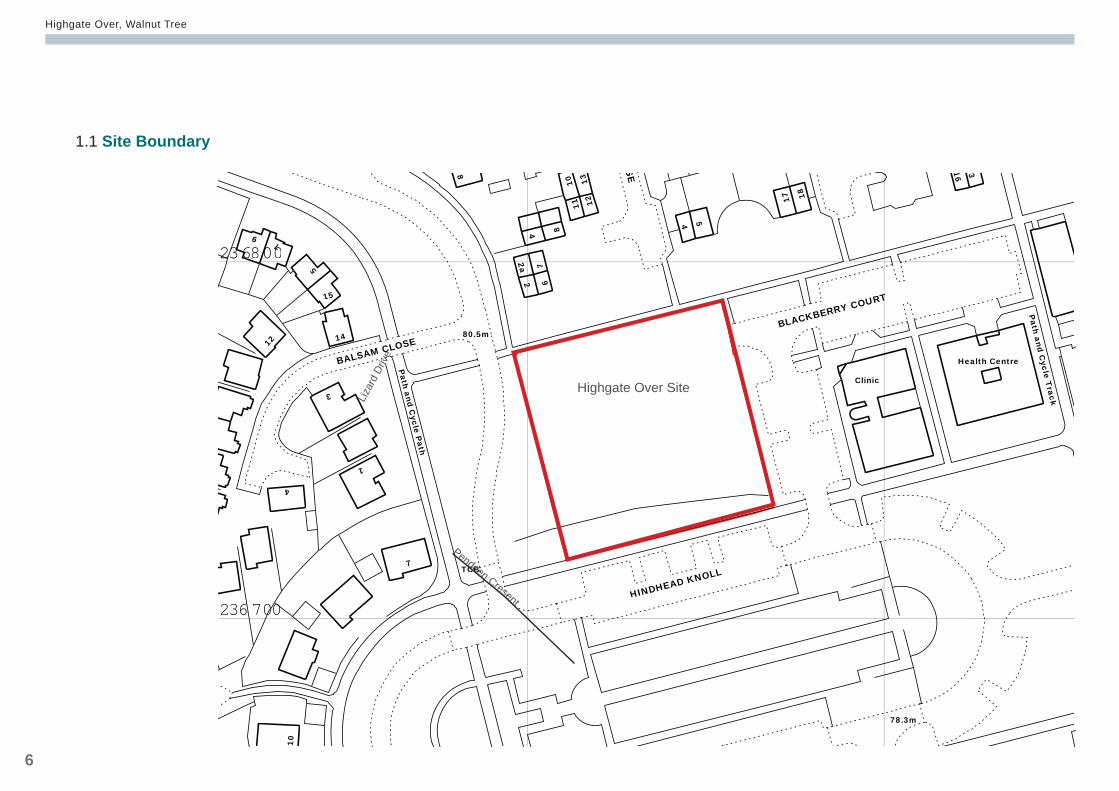
Site Boundary
Site Boundary
This map is reproduced from Ordnance Survey material with the permission of Ordnance Survey on behalf of the Controller of Her Majesty’s Stationery O�ce. © Crown Copyright. Unauthorised reproduction infringes Crown copyright and may lead to prosecution or civil proceedings. Milton Keynes Council 100019593
1.1 Site Boundary
Highgate Over Site
Pendeen Cresent
Liza
rd D
rive
Urban Design & Landscape Architecture
www.milton-keynes.gov.uk/udla 7
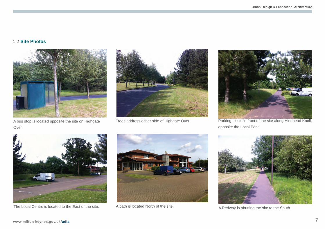
1.2 Site Photos
Trees address either side of Highgate Over.A bus stop is located opposite the site on Highgate Over.
Parking exists in front of the site along Hindhead Knoll, opposite the Local Park.
A path is located North of the site.The Local Centre is located to the East of the site. A Redway is abutting the site to the South.
SECTION 2THE SITE AND DEVELOPMENT OPTIONS
2.0 Access pg 9
2.1 Proposed Uses pg 9
2.2 Key Principles pg 9
2.3 Parameters Plan Options pg 9
2.4 Option 1 pg 10
2.5 Option 2 pg 11
2.6 Option 3 pg 12
2.7 Next Steps pg 13
Urban Design & Landscape Architecture
www.milton-keynes.gov.uk/udla 9
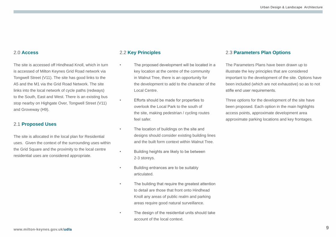
2.3 Parameters Plan Options
The Parameters Plans have been drawn up to illustrate the key principles that are considered important to the development of the site. Options have been included (which are not exhaustive) so as to not stifle end user requirements.
Three options for the development of the site have been proposed. Each option in the main highlights access points, approximate development area approximate parking locations and key frontages.
2.2 Key Principles
• The proposed development will be located in a key location at the centre of the community in Walnut Tree, there is an opportunity for the development to add to the character of the Local Centre.
• Efforts should be made for properties to overlook the Local Park to the south of the site, making pedestrian / cycling routes feel safer.
• The location of buildings on the site and designs should consider existing building lines and the built form context within Walnut Tree.
• Building heights are likely to be between 2-3 storeys.
• Building entrances are to be suitably articulated.
• The building that require the greatest attention to detail are those that front onto Hindhead Knoll any areas of public realm and parking areas require good natural surveillance.
• The design of the residential units should take account of the local context.
2.0 Access
The site is accessed off Hindhead Knoll, which in turn is accessed of Milton Keynes Grid Road network via Tongwell Street (V11). The site has good links to the A5 and the M1 via the Grid Road Network. The site links into the local network of cycle paths (redways) to the South, East and West. There is an existing bus stop nearby on Highgate Over, Tongwell Street (V11) and Groveway (H9).
2.1 Proposed Uses
The site is allocated in the local plan for Residential uses. Given the context of the surrounding uses within the Grid Square and the proximity to the local centre residential uses are considered appropriate.
Highgate Over, Walnut Tree
10
Walnut Tree - Highgate Over N
Draft 1NS
Option 1
© Crown Copyright and database rights [2012]. Ordnance Survey [100019593]
27/06/2014
Walnut Tree - Highgate Over
MC
Urban Design and Landscape ArchitecturePlanning, Economy and DevelopmentCivic Offices | Saxon Gate East | Milton Keynes | MK9 3EJ
MKDP
1/500@A3
Site Boundary
Approximate Buiding Zone
Parking and /or Servicing
Key Frontage
Retained Trees / Hedges
Trees / Hedge to be Retained if Layout Permits
Suggested Access to Site
Suggested route through the site
Existing Redway
Land Use Local Centre
Land Use Residential
Land Use Linear Park
2.4 Option 1
Urban Design & Landscape Architecture
www.milton-keynes.gov.uk/udla 11
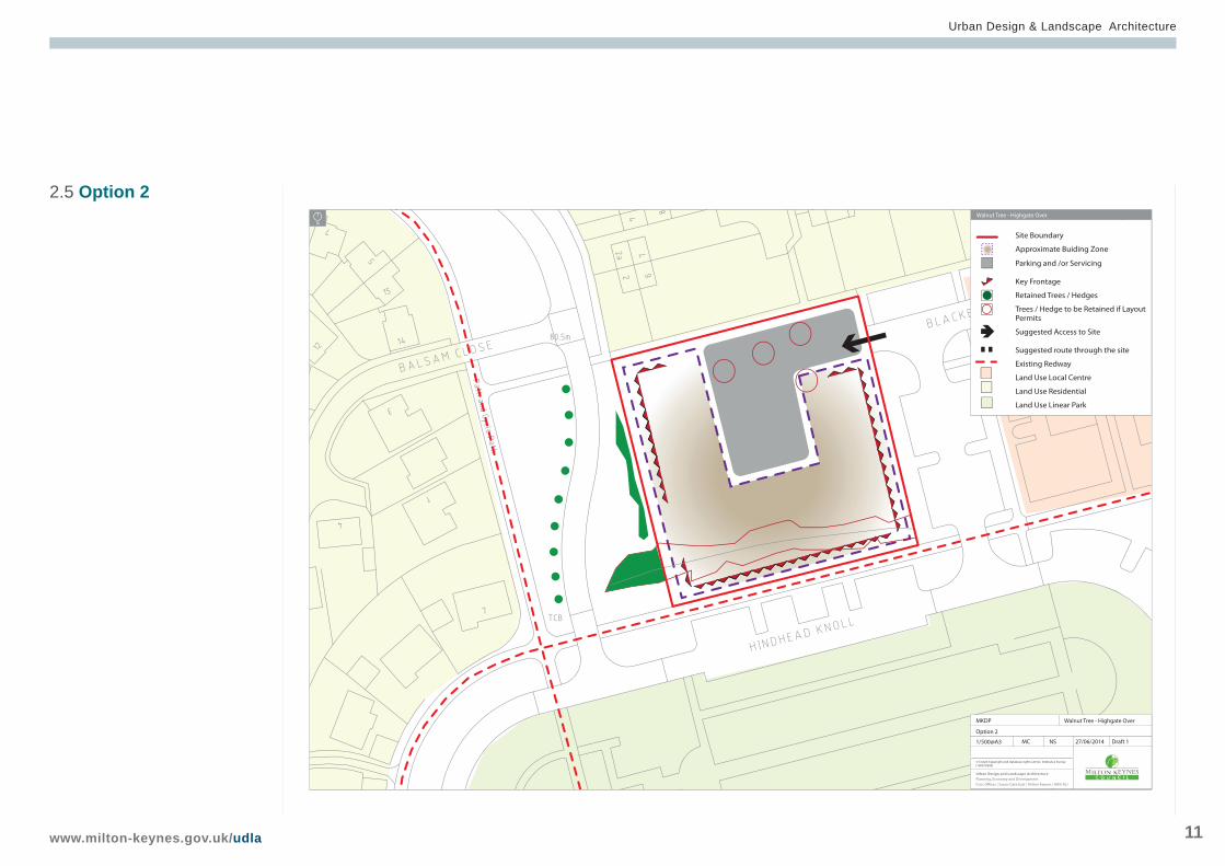
2.5 Option 2Walnut Tree - Highgate Over
N
Draft 1NS
Option 2
© Crown Copyright and database rights [2012]. Ordnance Survey [100019593]
27/06/2014
Walnut Tree - Highgate Over
MC
Urban Design and Landscape ArchitecturePlanning, Economy and DevelopmentCivic Offices | Saxon Gate East | Milton Keynes | MK9 3EJ
MKDP
1/500@A3
Site Boundary
Approximate Buiding Zone
Parking and /or Servicing
Key Frontage
Retained Trees / Hedges
Trees / Hedge to be Retained if Layout Permits
Suggested Access to Site
Suggested route through the site
Existing Redway
Land Use Local Centre
Land Use Residential
Land Use Linear Park

Highgate Over, Walnut Tree
12
2.6 Option 3Walnut Tree - Highgate Over
N
Draft 1NS
Option 2
© Crown Copyright and database rights [2012]. Ordnance Survey [100019593]
27/06/2014
Walnut Tree - Highgate Over
MC
Urban Design and Landscape ArchitecturePlanning, Economy and DevelopmentCivic Offices | Saxon Gate East | Milton Keynes | MK9 3EJ
MKDP
1/500@A3
Site Boundary
Approximate Buiding Zone
Parking and /or Servicing
Key Frontage
Retained Trees / Hedges
Trees / Hedge to be Retained if Layout Permits
Suggested Access to Site
Suggested route through the site
Existing Redway
Land Use Local Centre
Land Use Residential
Land Use Linear Park
Urban Design & Landscape Architecture
www.milton-keynes.gov.uk/udla 13
2.7 Next Steps
MKDP will draft a Marketing Brief for the site in line with the advice in the pre-application report.

Highgate Over, Walnut Tree
14
Section 3APPENDIX
Appendix 1 pg 15
Pre - application Report from Development Management
Appendix 2 pg19
Comments from Ward Members and or Parish Councils
Urban Design & Landscape Architecture
www.milton-keynes.gov.uk/udla 15
Appendix 1 Application no: 14/01839/PREMED
Proposal: Residential UseAt: Land to West of, Blackberry Court, Walnut Tree, Milton Keynes,
I write regarding the pre-application submission relat-ing to the above site and proposed development brief.
On reviewing the proposal I note the following:
Planning ConstraintsThe application site is a square 0.36 hectare site within the Walnut Tree residential grid square. There are residential properties to the north. To the east is Blackberry Court with the existing local centre. To the south of the site is an area of existing public open space which is on the adjacent side of Hindhead Knoll. There is an existing redway link to the west of the site. The site is currently covered by grass and existing trees. The plot is allocated for a residential use within the Local Plan Proposals Map. The site is currently accessed off Hindhead Knoll; there is an existing bus stop on Overgate.
Proposal detailsThe submitted development brief proposes three layout options for residential development within the
site which are discussed in detail below. The develop-ment brief identifies that development within this site is within a key location within Walnut Tree with an oppor-tunity to add to the character of the local centre. Devel-opment within this location should overlook the local park to the south providing surveillance of pedestrian and cycle routes, specific attention should be paid to buildings fronting Hindhead Knoll. Buildings on the site reflect the existing built form and building lines within Walnut Tree. Building heights should be 2-3 storeys, with suitably articulated entrances.
Planning PolicyPlanning applications are determined on the basis of the various National and Local planning policies. The following are the most relevant National and Local planning policies against which this application would be assessed. The local planning policies and guidance are available to view online at http://www.milton-key-nes.gov.uk/planning-policy/
National Planning Policy Framework (NPPF) March 2012
Core Strategy Adopted July 2013CS8 Other Areas of ChangeCS10 Housing
Highgate Over, Walnut Tree
16
CS12 Delivering Successful NeighbourhoodsCS13 Ensuring High Quality, Well Designed PlacesCS18Healthier and Safer communitiesCS19 Historic and Natural EnvironmentCS 21 Delivering infrastructure
Milton Keynes Local Plan (2001- 2011) (Saved Poli-cies)D1 Impact on Development proposal on localityD2 Requiring Good DesignD2A Urban Design AspectsD4 Sustainable constructionT3, T4 Pedestrian and cyclistsT10 TrafficT15 Parking ProvisionH1 Land Allocated for HousingH3 to H5 Affordable HousingH8 Housing DensityH9 Housing mixNE2 Protected SpeciesNE3 Biodiversity and Geological EnhancementsSupplementary Planning GuidanceParking Standards January 2016New Residential Development Design Guide 2012 Sustainable Construction (2007)
The principle of developmentThe site is allocated within the Local Plan Proposals Map for a residential use on this basis the principle of residential development within this location is consid-ered acceptable.
HighwaysThe Highways Officer has commented that the exist-ing redway route should have natural surveillance from within the site, linking to the existing network. The prin-cipal of good surveillance over all pedestrian and cycle routes is also supported from a highways perspective. Ease of access through the site should be provided to the nearby bus stop. All turning heads within the site should comply with the turning head layouts set out within the New Residential Development Design Guide. Parking will need to provided inaccordance with the adopted Milton Keynes Parking Standards (January 2016) and secure cycle stor-age will need to be provided within the development. Dependant on the gross floor area of the proposed development a transport statement and travel plan may be required to accompany an outline or full plan-ning application.
Ecology
There are known records of bats and badgers within the vicinity of the site. The Councils Countryside Of-ficer has undertaken a site visit and notes that the site is lightly wooded and bounded to the south by a hedge containing a few standard trees. The wooded area contains some mature coppice and seed/berry bear-ing species. Consequently, it is likely to be attractive to birds, small mammals and bats and badgers. On the day of the site visit, several bird species, predominant-ly finches and sparrows were present feeding on the seeds and berries. Proposed plans show the retention of trees and hedges “if the layout permits”. Any remov-al of trees or hedges will reduce the wildlife potential of the site for which compensation will be sought. In line with recognised good practice and governmen-tal policy on biodiversity and sustainability (National Planning Policy Framework 2012 & NERC 2006), all practical opportunities should be taken to harmonise the built development with the needs of wildlife. The NPPF seeks to provide a net enhancement to biodi-versity through sustainable development. Any proposal provided with a full application must demonstrate suffi-cient biodiversity enhancements to comply with current policies. The NPPF seeks to provide a net enhance-ment to biodiversity through sustainable development; as such biodiversity compensation will be sought for the removal of any trees or hedges. Any application on
Urban Design & Landscape Architecture
www.milton-keynes.gov.uk/udla 17
this site would require an Extended Phase 1 Habitat Survey, including a desk study with a species data search from the Buckinghamshire and Milton Keynes Environmental Records Centre. An ecological survey would be required to be undertaken at the appropriate time of year and following best practice methodology for any protected species identified in the Extended Phase 1 Habitat survey and reports including any nec-essary mitigation measures with regards to protected species. Following the completion of survey details of the necessary mitigation measures with regards to protected species and a Biodiversity Enhancement Scheme should be submitted in support of an ap-plication. Any application on this site should include details of bird and bat features which should be built into dwellings wherever possible. Given that there is a known record of bats within the vicinity of this site a lighting plan would also be required.
Landscape ArchitectThe Councils Landscape Architect has commented that the boundary of the site fronting Hindhead Knoll contains larger trees including Ash and an estab-lished Oak. The current proposals show the complete removal of these trees on all three options, which the landscape architect opposes.
Urban DesignThe Council’s Urban Design officer has commented that development on Hindhead Knoll should be the key frontage of this site, with development fronting the street and providing active frontages. Development should also reflect that Lichfield Down is considered to be an important route through Walnut Tree and is generally fronted by development. Whilst it is acknowl-edged that there is a significant amount of planting along this boundary whichshould be retained it is considered that there may be potential for selective thinning to create some frontage onto Lichfield Down.
Option 1Option 1 proposes development within the centre of the site and parking provision to the north of the site. This option includes three suggested access points to the site, one in the northwest corner of the site off Lichfield Down, a further access from Lichfield Down in the south west corner of the site and a third access point in the north east corner of the site off Blackberry Court. This options identifies key frontages to the south (onto Hindhead Knoll), in the north east corner to address Blackberry Court and the north western corner to address Lichfield Down. The option includes
two routes through the north and south of the site on an east west axis. One existing tree within the site is proposed for retention in the north of the site within the proposed parking area.The Highways Officer has commented that one of the three access points shown for proposal 1 located nearest to Hindhead Knoll should be moved further north away from the Redway/ Junction to avoid conflict between pedestrians, cyclists and vehicles.
Option 2Option 2 proposes development in the east, west and southern element of the site located around a parking area provided in the north and central area of the site. This option proposes a single access point in the north east of the site located off Blackberry Court, which the Highways Officer has commented is acceptable. This option identifies key frontages to the east (onto Blackberry Court), south (onto Hindhead Knoll) and in part on the western boundary of the site (onto Lichfield Down). There are no routes through the site proposed within this option. An area of the hedge onto Lichfield Down is also proposed for retention.
Option 3Option 3 proposes development in the east, west and southern element of the site located around a parking
Highgate Over, Walnut Tree
18
area provided in the north and central area of the site. This option proposes a single access point in the north east of the site located off Blackberry Court, which the Highways Officer has commented is acceptable. This option identifies key frontages to the east (onto Black-berry Court), south (onto Hindhead Knoll) and on the internal western elevation fronting the car park. There are no routes through the site proposed within this op-tion. An area of the hedge onto Lichfield Down is also proposed for retention.
In conclusion it is considered that the principle of residential development on this site is acceptable. In highways and urban design terms option 2 is currently considered to be most appropriate on the basis this layout would create a single access point into the site and would result in the creation of an area of front-age onto Lichfield Down. That said the creation of a frontage in this location should be balanced against the retention of the existing hedge on the basis of the strong contribution this makes to the wider landscape.I trust that this information is of assistance to you and outlines the issues which would be considered in determing a formal planning application on this site. These comments are
based on the information provided at this stage and
do not represent the views of the Council as a whole. This advice is given at officer level only on an informal basis and does not prejudice any future decision made by the Council in respect of this site.
Please note that any further consideration of the pre-application submission would necessitate a further submission and applicable fee.
Yours faithfully,Sarah HineSenior Planning OfficerOn behalf of Head of Development Management
Urban Design & Landscape Architecture
www.milton-keynes.gov.uk/udla 19
Comment by Zoe Stevenson - Walton Community Council
Following on from our conversation earlier regarding the above pre application.
Highgate Over.A committee meeting was held on the 17th July 2014 whereby Walton Community Council objected to the proposed residential development at the land adjacent to Highgate Over, Walnut Tree. WCC strongly recom-mend that the area should remain as a community open space. The area provides a green space in an otherwise very dense area. The only other uses that should be considered are an expansion of medical facilities/ community services in the area to reflect the expected growth of the population resulting from the proposed development at Church Farm.
Please feel free to contact me should you require any further information.Please could you acknowledge receipt of this email.
Many ThanksZoe StevensonAssistant Clerk to Walton Community Council
Appendix 2

Urban Design & Landscape Architecture Planning and TransportMilton Keynes CouncilPO Box 113, Civic Offices1 Saxon Gate EastMilton Keynes, MK9 3HN
T +44 (0) 1908 252708F +44 (0) 1908 252329E [email protected]
www.milton-keynes.gov.uk/udla
Available in audio, large print, braille and other languages
01908 252708


