47
MLPA Master Plan Science Advisory Team Responses to Science Questions Posed During the MLPA North Central Coast Process

MLPA Master Plan Science Advisory Team
Responses to Science Questions Posed During the MLPA North Central Coast Process

California MLPA Master Plan Science Advisory Team Responses to Science Questions Posed by the
NCCRSG at its July 10-11, 2007 Meeting Revised November 20, 2007
The following are responses of the MLPA Master Plan Science Advisory Team (SAT) to questions posed by the MLPA North Central Coast Regional Stakeholder Group (NCCRSG) at its July 10-11, 2007 meeting. Draft responses to questions were prepared by SAT work groups and then approved by the SAT. 1. Review of the measurability of the draft regional objectives (John Ugoretz, Mark Carr,
Sarah Allen, Karina Nielson) Response: At the September 17, 2007 SAT meeting the SAT approved of the NCCRSG’s provisional goals and objectives since fundamentally they are measurable, though some would be easier to measure than others. [During the central coast process a Baseline Science Management Panel considered the measurability for each objective and identified monitoring activities that could occur. A similar process could be conducted for the NCCSR goals and objectives during the development of a monitoring plan for the NCCSR]
2. What are the key and/or unique habitats for this region? (in relation to Goal 4, Objective 1)
This response was adopted by the SAT at its September 17, 2007 meeting.
Response: For Goal 4, Objective1, the NCCRSG asked the SAT to identify "unique habitats" in the study region. For purposes of representing unique habitats with important marine resources in the region, the stakeholders should include estuaries, the intertidal zone at the Farallon Islands, and subtidal waters (including the water column and benthic habitats) around the Farallon Islands. While estuaries are found along the California coast, the north central coast study region has about 20 square miles of estuaries of several different types. Tomales Bay, for example, is relatively unique due to its long narrow shape (originating along a fault zone), protected waters and varied habitats (deep waters, extensive eelgrass, and mudflats). The Farallons are truly unique as offshore islands surrounded by deepwater habitat, located offshore of the outlet of San Francisco Bay, and in an area bathed by nutrient-rich upwelled water from the Point Arena-Point Reyes upwelling system. They contain a globally significant and unique combination of marine mammal and seabird breeding colonies and have intertidal communities that are distinctly different than on the mainland. In addition to these two habitats identified as unique and warranting representation in marine protected areas, there are two other features of the region worth considering during MPA planning. First, it should be recognized that intertidal and subtidal habitats north and south of Point Reyes have different biological assemblages (there's a biogeographic break
MLPA Master Plan Science Advisory Team Responses to Science Questions Posed by the NCCRSG at its July 10-11, 2007 Meeting
(revised November 20, 2007)
2
at Point Reyes). Secondly, the freshwater plumes in the region are important for their influence on nearshore communities and for their role as migratory corridors for anadromous fish (salmon, steelhead, sturgeon). The output of San Francisco Bay at the Golden Gate is the largest outflow of estuarine freshwater in the entire state, draining 40% of California including the Sacramento and San Joaquin Rivers. References Dickey, K. 2003. Pieces of a puzzle: Biogeography of southeast Farallon Island, California.
J. Phycol. 39, S1: 13. Ford, R.G. and M.L. Bonnell. 1998. Marine protected areas and biological distributional
data: large and small scale perspectives. Taking a look at California’s ocean resources: an agenda for the future 1: 259.
Hanni, K.D., D.J. Long, R.E. Jones, P. Pyle, and L.E. Morgan. 1997. Sightings and strandings of Guadalupe fur seals in central and northern California, 1988-1995. J. Mammalogy 78: 684-690.
Long, D.J. 1992. Confirmation of the northern range of the snubnose sculpin (Orthonopias triacis). Calif. Fish Game 78: 160-162.
Roletto, J., N. Cosentino, D.A. Osorio, and E. Ueber. 2000. Rocky intertidal communities at the Farallon islands. 2000. Proceedings of the fifth California islands symposium: 359-362.
Steger, J.M., F.B. Schwing, C.A. Collins, L.K. Rosenfeld, N. Garfield, and E. Gezgin. 2000. The circulation and water masses in the Gulf of the Farallones. Deep-Sea Research II 47: 907-946.
3. What are the species most likely to benefit in the MLPA North Central Coast Study
Region? (Mark Carr, John Ugoretz, Gerry McChesney, Pete Raimondi)
Response: The list of species likely to benefit in the MLPA North Central Coast Study Region was approved by the SAT at its October 1, 2007 meeting. The SAT may choose to make further additions and edits to this list in the future. This list can be found in the North Central Coast Regional Profile.
4. Do the existing depth zones need to be split up or revised (esp. 30-100 meters) given that we have only minimal area >100m? (Stakeholders noted that there's a little area as deep as 116m). Do they need to represent depths >100m? (Mark Carr, John Ugoretz, Pete Raimondi) This response was adopted by the SAT at its September 17, 2007 meeting. Response: The SAT recommends that the depths between 30 and 100 meters be considered one depth zone in terms of replication and spacing analyses for this study region. This reaffirms the SAT guideline that MPAs should be designed to extend from shallow to deep water to encompass the full range of depth related migrations many species make throughout their life cycle. Ideally, most MPAs would span across the full 30-
MLPA Master Plan Science Advisory Team Responses to Science Questions Posed by the NCCRSG at its July 10-11, 2007 Meeting
(revised November 20, 2007)
3
100 m range, but in certain locations and to meet other goals, individual MPAs may only encompass on portion of this range. Given the differences in preferred depth ranges of various species, analyses of benefits to individual species or species groups should take into account these preferred depths. As with other habitats that are not present or very rare in the region, depths greater than 100 meters would not be considered in habitat analyses.
Background: Presumably, consideration for splitting the 30-100 meter depth range into finer depth strata is motivated by a concern that MPAs located within that depth range, but not across the entire depth range, would fail to represent some species within the range. For example, if the depth distribution of one or more species ranged from 30-60 m depth and an MPA was proposed that extended from 60 m and deeper, than that MPA would not include and provide protection for those shallower distributed species. There are two components to the response to this question:
1. Are there species whose depth distribution includes some but not all of the 30-100m range? And, if so,
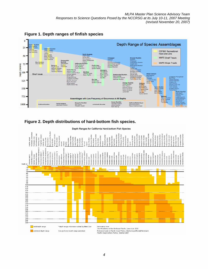
2. What are the implications for redefining depth strata on the design of MPAs? The SAT reviewed literature on the depth distribution of some species that occur in the 30-100m depth range of the MLPA North Central Coast Study Region to determine if there is evidence of ranges that span only a portion of the 30-100m range. This review focused on marine fishes and was generated from two key resources. The depth distribution of fish assemblages illustrated in Figure 1 is from NOAA’s National Center for Coastal Monitoring and Assessment (CMA) biogeographic assessment of the three central coast national marine sanctuaries1. The depth distributions of hard-bottom fishes illustrated in Figure 2 is largely based on rockfishes from species accounts in The Rockfishes of the Northeast Pacific2. A parallel synthesis of soft-bottom fish depth distributions was also conducted and largely reinforced the results and conclusions generated from the other syntheses (Figure 3).
1 Information on how these assemblages were defined is available at: http://ccmaserver.nos.noaa.gov/products/biogeography/canms_cd/htm/fish/assemblage.htm. 2 Love, M.S., M. Yoklavich, and L. Thorsteinson. 2002. University of California Press, Berkeley, California, USA 405 pages
MLPA Master Plan Science Advisory Team Responses to Science Questions Posed by the NCCRSG at its July 10-11, 2007 Meeting
(revised November 20, 2007)
4
Figure 1. Depth ranges of finfish species
Figure 2. Depth distributions of hard-bottom fish species.

MLPA Master Plan Science Advisory Team Responses to Science Questions Posed by the NCCRSG at its July 10-11, 2007 Meeting
(revised November 20, 2007)
5
Figure 3. Depth distributions of soft-bottom fish species.
It is clear from depth distributions of entire fish assemblages (Figure 1; bocaccio, greenspotted rockfish, Pacific herring, halfbanded rockfish, Pacific sanddab, and big skate) and the preferred (dark orange) depth range of rockfishes (Figure 2; Sebastes serriceps, S. melanops, S. carnatus, and many species including and to the right of S. miniatus) that certain species and assemblages occur within only a portion of the 30-100 m depth range. Thus, an MPA that includes only a portion of the 30-100 m depth range may not include species that otherwise occur within the depth range. This analysis did not consider benthic invertebrates, which may exhibit similar discontinuous distributions across this depth range. It is also notable that the upper and lower depth ranges of many of these species occurs around 60 m depth. There are two implications of these results. First, the 30-100 m depth range could be divided into separate 30-60 and 60-100 m depth strata, thereby assuring that each of these strata and their corresponding species and assemblages are represented in MPAs. Alternatively, MPAs could be designed to encompass the entire 30-100m depth range. Both guidelines would help meet the goal of representative biodiversity within this range. Of the two alternatives, the latter is the most scientifically sound for the following reason. Separate

MLPA Master Plan Science Advisory Team Responses to Science Questions Posed by the NCCRSG at its July 10-11, 2007 Meeting
(revised November 20, 2007)
6
from including representative species, the design of MPAs needs to consider depth-related movement patterns of marine species. There are a number of marine fishes that move across broad depth ranges during their adult phase, especially in relation to annual reproductive migrations into shallower depths (e.g., lingcod). Other species known to move across depth ranges as adults include olive, yellowtail, canary and vermillion rockfishes (Rick Starr, pers. comm.). Indeed, recognition of this behavior led the central coast SAT to recommend the guideline that MPAs be designed to extend from the intertidal to the boundary of state waters to encompass the depth-related movements of various species across the range of depths in state waters. Overall, the SAT would interpret these data to recommend that MPAs in the 30-100 m depth range encompass as much of this depth range as possible, thereby protecting the collective number of species that occur there and accommodate their depth-related migrations. There is very little area in state waters that is deeper than 100m and it extends only a small range of depth (100-116m depth). This indicates that waters deeper than 100 m within state waters would be such an insignificant portion of the range of most species that it would not be an important guiding criterion for MPA location.
5. What is the influence of offshore habitats (e.g. Bodega canyon) on state waters? (Sarah Allen, Mark Carr, Dominic Gregorio) This response was adopted by the SAT at its November 13, 2007 meeting. Draft response: The SAT was unable to find any scientific information that directly addresses the influence of offshore habitats on the ecological communities in state waters; however, it is possible that offshore features influence the biological communities in state waters in several ways. Upwelling Bodega Canyon may be an offshore upwelling center, but given its distance from shore (~20 mi), it is unlikely that upwelled water from Bodega Canyon has any noticeable impact on state waters. The SAT examined the National Marine Fisheries Service Triennial Trawl Survey data to see whether the abundance or biodiversity of mid-depth (<100m) shelf species varied with proximity to Bodega Canyon and a potential source of productive upwelled water. Unfortunately, the trawl samples were distributed too broadly to assess any specific influences of Bodega Canyon (see figure 1). Also large temporal variation in the biodiversity and abundance of species in the trawls made it impossible to discern any spatial variations. In general, upwelling along the shelf break can cause algal blooms and enhanced productivity, however these events are transient and not known to originate from any specific features, therefore it is impossible to predict their impacts on state waters and how these impacts may vary along the coast.

MLPA Master Plan Science Advisory Team Responses to Science Questions Posed by the NCCRSG at its July 10-11, 2007 Meeting
(revised November 20, 2007)
7
Figure 2
Wave Energy Offshore bathymetric features can influence the patterns of swell and wave energy along the nearby coastline. Cordell Bank and the potato patch (bar at the mouth of San Francisco Bay) are known to focus wave energy, increasing the height of waves where they encounter the coast (see figure 2). The location of the enhanced wave energy and the magnitude of this effect vary with swell period and direction, making specific predictions about impacts difficult. Elsewhere in California, swell environment has been shown to be an important factor influencing assemblages of nearshore fishes, so it is possible that variations in swell energy caused by Cordell Bank and the potato patch could influence ecological communities in state waters, but the effect has not been documented.
Figure 1
Population Connectivity Cordell Bank is known to be an important habitat for deeper water reef species including rockfish. Larval dispersal from the bank to nearshore waters is likely, however the distribution of this dispersal and its impact on nearshore communities is currently unknown.

MLPA Master Plan Science Advisory Team Responses to Science Questions Posed by the NCCRSG at its July 10-11, 2007 Meeting
(revised November 20, 2007)
8
6. What is the appropriate size/seasonality for buffers to prevent disturbance to
bird/mammal colonies? (Sarah Allen, Gerry McChesney) This response was adopted by the SAT at its September 17, 2007 meeting. Response: BUFFER DISTANCES TO PREVENT BOAT DISTURBANCE TO SEABIRD AND MARINE MAMMAL COLONIES Seabirds Species of seabirds differ in how prone they are to disturbance by boats. Those that nest and roost on the surface are more sensitive to disturbance than those nesting in underground burrows. In particular, species nesting or roosting in dense aggregations tend to most sensitive to disturbance because disturbance events can affect larger numbers of birds. The species most sensitive to disturbance include the common murre, Brandt’s cormorant, double-crested cormorant, and pelagic cormorant. Pigeon guillemots, which nests underground, congregate in large numbers on the water and in intertidal areas adjacent to nesting areas and are highly prone to flush (fly away) when boats approach too closely. Few studies have examined boat disturbance distances at seabird colonies. In a study on seabird disturbance at the Three Arch Rocks National Wildlife in coastal Oregon, 98% of boat disturbances occurred within 500 feet of the colony (Riemer and Brown 1997). Using data from that study, a 500 foot closure was established around the nesting rocks. This closure resulted in a significant decrease in disturbance to wildlife. At certain colonies along the central California coast, the U.S. Fish and Wildlife Service records boat and other disturbances to seabirds with a focus on the common murre. Observations are separated into events causing birds to become visibly frightened or agitated and those causing birds to move or flush from the colony. From these observations, 80% of events causing alarm and 90% of events causing flushing occurred within 200 meters (about 650 feet) of nesting colonies (Table 1). Ninety percent of agitation and 100% of flushing events occurred within 400 meters (1,300 feet). However, other observations have shown birds flushing at distances over 400 meters, especially outside the breeding season when birds are more prone to flush. Based on these data, the 500 foot closure used at Three Arch Rocks in Oregon would not alleviate all disturbances to seabirds. A buffer zone about 400 meters would be needed to nearly eliminate flushing events, and about 500 meters would be needed to nearly eliminate all detectable disturbance events. NOTE: These data do not include other factors that could cause substantial disturbance to seabirds, such as bright lights used on some boats on night, or loud noises.

MLPA Master Plan Science Advisory Team Responses to Science Questions Posed by the NCCRSG at its July 10-11, 2007 Meeting
(revised November 20, 2007)
9
Table 1. Cumulative percentages in 50 meter (164 ft.) distance zones of boat disturbances to seabird breeding colonies along the central California coast, 1996-2006 (N = 102 events). Data are shown separately for events causing alarm behaviors and those causing flushing behaviors. (U.S. Fish and Wildlife Service, unpublished data).
Distance (m)
Distance (ft.)
Alarm Behaviors Cumulative
%
Flushing Behaviors Cumulative
% 0-50 0-164 46.9 66.7
50-100 164-328 65.4 76.2100-150 328-492 67.9 76.2150-200 492-656 80.2 90.5200-250 656-820 85.2 95.2250-300 820-984 91.4 95.2300-350 984-1148 91.4 95.2350-400 1148-1312 95.1 100.0400-450 1312-1476 95.1 100.0450-500 1476-1640 97.5 100.0
>500 >1640 100.0 100.0
Marine Mammals The National Marine Fisheries Service recommends a buffer zone of 300 feet around marine mammal colonies to prevent disturbance; these recommendations are on the NMFS website: http://www.oceanservice.noaa.gov/outreach/pdfs/wildlife_watching_handbook.pdf Additionally, in a study of harbor seals in Bolinas Lagoon in the 1970s, most seals were disturbed at around 300 feet (Allen et al. 1985). At Three Arch Rocks National Wildlife Refuge, Oregon, Riemer and Brown (1997) reported that nearly all disturbances to wildlife occurred within 500 feet of the colony. Literature Cited Allen, S. G., D. G. Ainley, G. W. Page, and C. A. Ribic. 1985. The effect of disturbance on
harbor seal haul out patterns at Bolinas Lagoon, California, 1978-1979. U. S. Fishery Bull. 82:493-500.
Riemer, S. D., and R. F. Brown. 1997. Monitoring human-wildlife interactions and disturbance of seabirds and pinnipeds at Three Arch Rocks National Wildlife Refuge, 1993-1994. Unpublished Report, Oregon Department of Fish and Wildlife, Wildlife Diversity Program, Marine Region, Newport, Oregon, Technical Report #97-6-01.
U.S. Fish and Wildlife Service, unpublished data. San Francisco Bay National Wildlife Refuge Complex, Common Murre Restoration Project. Contact: Gerry McChesney
MLPA Master Plan Science Advisory Team Responses to Science Questions Posed by the NCCRSG at its July 10-11, 2007 Meeting
(revised November 20, 2007)
10
7. Can the SAT review and comment on the list of important features in the draft regional profile (section 3.3)? (Steve Morgan and John Largier) This response was adopted by the SAT at its October 1, 2007 meeting. Response: Spatial data are available to begin identifying specific locations in the study region that have high biodiversity significance based on the guidelines provided in the MLPA Master Plan Framework (CDFG 2005) and results of regional scientific research and mapping efforts. Specific locations can be identified using existing maps, by overlaying relevant data layers in the Internet Mapping Service site, or conducting more sophisticated GIS analysis. The following is a partial list of types of areas that have regional biodiversity significance:
• Areas where numerous habitats are found in close proximity and areas with unique combinations of habitats
• Large open estuaries (e.g. Tomales Bay, Drakes Estero, Bolinas Lagoon) with eelgrass beds, tidal flats, and coastal marsh (Maps 2a-2f)
• Stream outlets and estuaries with presence of coho, Chinook, or steelhead populations (Maps 6a and 6b)
• Marine areas off headlands, especially those with kelp forests. • Marine areas which offer residence adjacent to upwelling centers, especially those
with kelp forests and rocky reefs. • Large kelp beds (Maps 2a-2f) and nearshore rocky reefs (Maps 3a-3f). • Areas of high bathymetric complexity which provide topographic relief and a variety
of habitats in close proximity • Rocky subtrata in all depth zones, since rocky habitat is much less common than
soft-bottom habitat and is important for depleted rockfish species (Maps 3a-3f) • Rocky intertidal shores, especially wave-cut rocky platforms (which provide habitat
at diverse tidal elevations), boulder fields, and rare sheltered rocky shores (Maps 2a-2f)
• Seabird colonies and marine mammal rookeries and haulouts (Maps 5a-5f) • Areas of high fish or seabird diversity and/or density (Maps 5a-5f, 6a-6b, and 7a-7e). • Offshore islands
8. Are there biological breaks in species distribution with in the study region if so
where and which are important to consider? (Steve Gaines, Pete Raimondi, Mark Carr) This response was adopted by the SAT at its September 17, 2007 meeting. Response: There are two levels of biogeographic patterns of species and biological communities relevant to the MLPA process; major “biogeographic regions” and smaller “bioregions”. Biogeographic regions are largely defined by species range boundaries common to many species. For example, Point Conception is a well recognized

MLPA Master Plan Science Advisory Team Responses to Science Questions Posed by the NCCRSG at its July 10-11, 2007 Meeting
(revised November 20, 2007)
11
biogeographic boundary that separates two biogeographic regions to the south and north. These biogeographic regions are described in detail in the previous SAT’s description provided in the MLPA master plan. Biologically-based subregions within these biogeographic regions are referred to as “bioregions”. These are regions that are characterized by differences in species composition and community structure within habitat types or ecosystems (e.g., within the rocky intertidal, within shallow hard-bottom habitats). For example, in the MLPA Central Coast Study Region, the SAT recognized differences in community structure of rocky intertidal and shallow rocky reef communities to the north and south of Monterey Bay. Often, these subregions and the variation in communities they are based upon are closely related to differences in habitat structure. For example, the different shallow reef communities north and south of Monterey Bay correspond with sedimentary and granitic substrata, respectively. The purpose for defining these subregions is to recognize that MPAs in one subregion may not include the species composition and community structure of an ecosystem in other subregions. Within the MLPA North Central Coast Study Region, there are largely three subregions. First, rocky intertidal communities along the mainland from Pigeon Point to Point Reyes are different from those at and north of the Point Reyes headland. Specifically, the boundary between these two bioregions generally corresponds with a change in substratum type that occurs midway between Point Reyes and Tomales Point. These differences reflect, in part, differences in substratum type (sedimentary rock to the south and granitic rock to the north), but also the markedly different oceanographic environment north and south of Point Reyes. The third subregion is defined by the unique environment at the Farallon Islands as described in the “unique habitats” response by the SAT. There is an additional change in substratum types in the northern portion of the study region, but there are not data indicating corresponding changes in biological communities. It is reasonable to expect patterns in subtidal habitats to be similar to those of the more well studied intertidal habitats described here; such correspondence is common elsewhere in the state.

California MLPA Master Plan Science Advisory Team Responses to Science Questions Posed by the
NCCRSG at its August 22-23, 2007 Meeting Revised February 19, 2008
The following are responses of the MLPA Master Plan Science Advisory Team (SAT) to questions posed at the August 22-23, 2007 meeting of the MLPA North Central Coast Regional Stakeholder Group (NCCRSG). These responses have been prepared by work groups of the SAT and adopted by the SAT at various meetings. 1. Are the deep water benthic habitats and water column habitat around the Farallon
Islands unique as well as worthy of inclusion?
This response was adopted by the SAT at its October 1, 2007 meeting.
Response: The SAT has identified the intertidal, subtidal, and water column habitats around the Farallon Islands as unique. (Please refer to the response to Question 2 from the list of questions from the NCCRSG July 10-11, 2007 meeting.) Habitats that are unique are, according to the regional goals and objectives, worthy of inclusion.
2. Specifically – where does the subtidal start? For MLPA purposes does it only span to the extent of state waters or does it extend to XX depth (and if so what depth)?
This response was adopted by the SAT at its October 1, 2007 meeting.
Response: The subtidal includes all habitats deeper than the mean lower low water level, including state, federal, and international waters (Please refer to the response to Question 2 from the list of questions from the NCCRSG July 10-11, 2007 meeting).
3. What level of protection would you assign to marine protected areas (MPAs) that
allow take of salmon, abalone, urchin, clams, halibut, white seabass, and crab? (Mark Carr, Ray Hilborn)
Response: This response is incorporated in the document, Draft MLPA Evaluation Methods for MPA Proposals in the North Central Coast Study Region.
4. What is range and pattern of movement for the various life-stages of yellow-eye
rockfish, surfperch, greenling, cabezon, [monkeyfaced prickleback (a.k.a. monkeyfaced eel, Cebidichthys violaceus)] and [rock prickleback, (Xiphister mucosus)], halibut, and white seabass? (Mark Carr, Jan Freiwald)
This response was adopted by the full SAT at its November 13, 2007.
Response: A literature review conducted by Jan Freiwald shows that 75% of tagged individuals of the following species moved less than 0.5 km during the respective study periods which ranged in duration. Though the study periods varied, there was no significant relationship between the time individuals were at large and the distance they traveled.
• yellow-eye rockfish (Sebastes ruberrimus)

MLPA Master Plan Science Advisory Team Responses to Science Questions Posed at the August 22-23, 2007 Meeting of the
North Central Coast Regional Stakeholder Group (revised February 19, 2008)
2
• surfperch (Embiotoca jacksoni and E. lateralis) o Both of these species primarily occupy rocky and kelp habitats. Surfperches that
occupy other habitats may move different distances. • greenling (Hexagrammos decagrammus) • cabezon (Scorpaenichthys marmoratus) • monkeyface prickleback (Cebidichthys violaceus)*
* the study on monkeyface prickleback movement was excluded from the literature review analysis because fewer than 10 individuals were tagged. However, all tagged individuals moved less than 3 kilometers. The SAT was unable to find information on the movement of rock prickleback or white seabass. References Coombs, C. I. 1979. Reef fishes near Depoe Bay, Oregon: movement and the recreational fishery. Oregon State University. DeMott, G. E. 1983. Movement of tagged lingcod and rockfishes off Depoe Bay, Oregon. M.S. Thesis Oregon State University.
DeWees, C. M., and D. W. Gotshall. 1974. An experimental artificial reef in Humbold Bay, California. California Fish and Game 60.
Freiwald, unpublished Helm, R. C. 1990. Population dynamics of an intertidal eel blenny, Cebidichthys violaceus: Diet, growth, homing, and avian predation. Ph.D. Thesis. University of California Davis. Hixon, M. A. 1981. An experimental analysis of territoriality in the California reef fish Embiotoca jacksoni (Embiotocidae). Copeia 1981:653-665. Lea, R. N., R. D. McAllister, and D. VenTresca. 1999. Biological aspects of nearshore rockfishes of the genus sebastes from Central California with notes on ecological related sport fishes Fish Bulletin 177. Matthews, K. R. 1985. Species similarity and movement of fishes on natural and artificial reefs in Monterey Bay, California. Bulletin of Marine Science 37:252-270.
Miller, D. J., and J. J. Geible. 1973. Summery of blue rockfish and lingcod life histories; a reef ecology study, and giant kelp, Macrocystis pyrifera, experiments in Monterey Bay, California. Fish Bulletin 158:137.
MLPA Master Plan Science Advisory Team Responses to Science Questions Posed at the August 22-23, 2007 Meeting of the
North Central Coast Regional Stakeholder Group (revised February 19, 2008)
3
Ralston, S. L., and M. H. Horn. 1986. High tide movements of the temperate-zone herbivorous fish Cebidichthys violaceus (Girard) as determined by ultrasonic telemetry. Journal of Experimental Marine Biology and Ecology 98:35-50. California Halibut (Paralichthys Californicus) Tagging studies of California halibut indicate that the majority of individuals remain in a localized area for extended periods of time, while others move long distances along the coast (Domeier and Chun 1995, Posner and Lavenberg 1999). In the Posner and Lavenberg study, 65% of recaptured halibut were recaptured within 5.5km of their release site (this is the highest resolution of movement provided by the data). In the Domeier and Chun study, 60% of recaptured halibut moved less than 2 km during the study period. The authors note that most recaptured fish were at liberty for fewer than 100 days likely due to a high rate of tag loss, however even within that 100 days, some individuals moved more than 300 km. Any distinctions between adult and juvenile patterns of movement are still unclear, as few of the halibut in these tagging studies were larger than the sport fishery size limit of 56 cm total length (17% in the Domeier and Chun, only 3% in Posner and Lavenberg) In the Domeier and Chun study, halibut larger than 50 cm (approx 30% of sample size) tended to travel markedly greater distances than halibut smaller than 50 cm. A study focusing on juvenile California halibut settlement revealed preference either for bays or the open coast. However, almost all coastal settlers entered and used the bays as nursery areas during their first year of life, or else they died (Kramer 1991). References Domeier, ML and CSY Chun 1995. A Tagging Study of the California Halibut (Paralichthys Californicus). California Department of Fish and Game, CalCOFl Rep., Vol. 36 Kramer, SH 1991. Growth, mortality, and movements of juvenile California halibut Paralichthys californicus in shallow coastal and bay habitats of San Diego County, California. Fishery Bulletin 89(2) 195-207 Posner, M and RJ Lavenberg 1999. Movement of California halibut along the coast of California. California Fish and Game, Vol. 85(2) 45-55
5. In the MLPA Central Coast Study Region the recommendation to extend MPAs to the three mile state water limit to cover the range of depths and species that utilize the range of depths made sense but the north central coast study region is largely homogenous out to the three mile limit, so does it still require MPA extension to the three mile state water boundary?
This response was adopted by the SAT at its November 13, 2007 meeting.

MLPA Master Plan Science Advisory Team Responses to Science Questions Posed at the August 22-23, 2007 Meeting of the
North Central Coast Regional Stakeholder Group (revised February 19, 2008)
4
Response: The SAT recommends that MPAs be designed to extend from the intertidal to the boundary of state waters to encompass the depth-related movements of various species across the range of depths in state waters. The SAT recommends that MPAs in the 30-100 m depth range encompass as much of this depth range as possible out to the boundary of state waters, thereby protecting the collective number of species that occur there and accommodate their depth-related migrations. In the case that the habitat is homogeneous (uniform substrate and uniform depth ±5m) across a broad area, MPAs should be designed to encompass adult neighborhood sizes and movement patterns in both alongshore and cross-shore directions. In the design guidelines, the SAT recommends that MPAs span a minimum of 3 miles alongshore to encompass adult movement patterns. In cases where habitat is homogeneous across a broad area, adults are likely to extend their movement in both alongshore and cross-shore directions, therefore MPAs should also extend a minimum of three miles seaward (towards the state waters boundary) to encompass these movements. The SAT notes that extending MPA boundaries to the edge of state waters has the added benefit of allowing for connections with possible future MPA designations in federal waters.
(For additional information please refer to the response to Question 4 in the list of questions from the NCCRSG July 10-11, 2007 meeting.)
6. How do you evaluate proposals relative to Goal 2, Objective 2 for the protection of
foraging, nursery and rearing areas? a. Specifically, also considering seabirds, mammals, and sharks.
This response was adopted by the SAT at its November 13, 2007 meeting.
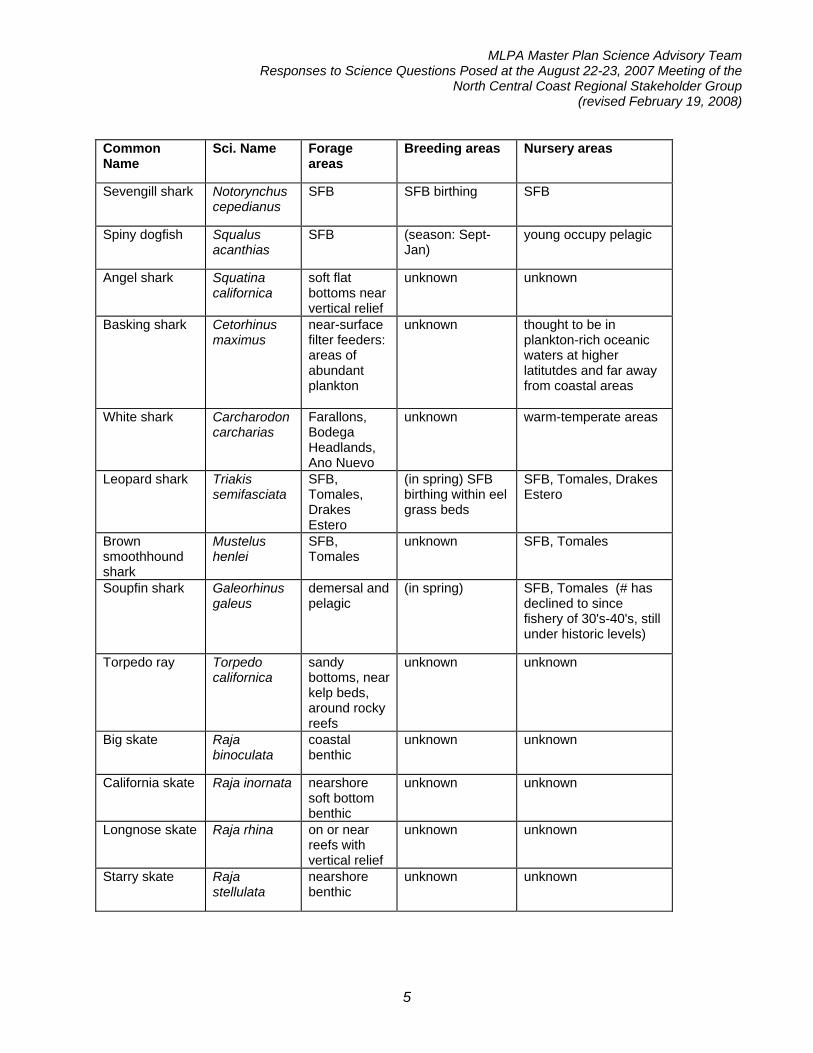
Response: (Question 6) Fish and invertebrates use habitats already named in the master plan for MPAs goals and objectives (such as estuaries and kelp forest/rocky reefs) for their foraging, nursery, and rearing activities. Therefore, evaluating proposals for protection of these habitats will suffice to evaluate protection of foraging, nursery and rearing areas for most fish and invertebrate species. Response: (Question 6a – reference to sharks) An analysis of available information about shark breeding, forage, and nursery areas indicates that sharks largely use habitats already named in the master plan for MPAs goals and objectives (such as estuaries and soft bottom) for these activities (see table below). Therefore, evaluating proposals for protection of these habitats will suffice to evaluate protection of foraging, nursery and rearing areas for most shark species in the study region. The special importance of estuarine habitats for certain species of shark should be noted. Proposals that protect a high proportion of the available estuarine habitats will be especially protective of these species. Common Name
Sci. Name Forage areas
Breeding areas Nursery areas
MLPA Master Plan Science Advisory Team Responses to Science Questions Posed at the August 22-23, 2007 Meeting of the
North Central Coast Regional Stakeholder Group (revised February 19, 2008)
5
Common Name
Sci. Name Forage areas
Breeding areas Nursery areas
Sevengill shark Notorynchus cepedianus
SFB SFB birthing SFB
Spiny dogfish Squalus acanthias
SFB (season: Sept-Jan)
young occupy pelagic
Angel shark Squatina californica
soft flat bottoms near vertical relief
unknown unknown
Basking shark Cetorhinus maximus
near-surface filter feeders: areas of abundant plankton
unknown thought to be in plankton-rich oceanic waters at higher latitutdes and far away from coastal areas
White shark Carcharodon carcharias
Farallons, Bodega Headlands, Ano Nuevo
unknown warm-temperate areas
Leopard shark Triakis semifasciata
SFB, Tomales, Drakes Estero
(in spring) SFB birthing within eel grass beds
SFB, Tomales, Drakes Estero
Brown smoothhound shark
Mustelus henlei
SFB, Tomales
unknown SFB, Tomales
Soupfin shark Galeorhinus galeus
demersal and pelagic
(in spring) SFB, Tomales (# has declined to since fishery of 30's-40's, still under historic levels)
Torpedo ray Torpedo californica
sandy bottoms, near kelp beds, around rocky reefs
unknown unknown
Big skate Raja binoculata
coastal benthic
unknown unknown
California skate Raja inornata nearshore soft bottom benthic
unknown unknown
Longnose skate Raja rhina on or near reefs with vertical relief
unknown unknown
Starry skate Raja stellulata
nearshore benthic
unknown unknown
MLPA Master Plan Science Advisory Team Responses to Science Questions Posed at the August 22-23, 2007 Meeting of the
North Central Coast Regional Stakeholder Group (revised February 19, 2008)
6
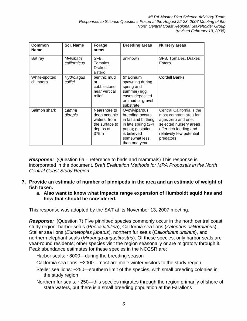
Common Name
Sci. Name Forage areas
Breeding areas Nursery areas
Bat ray Myliobatis californicus
SFB, Tomales, Drakes Estero
unknown SFB, Tomales, Drakes Estero
White-spotted chimaera
Hydrolagus colliei
benthic mud or cobblestone near vertical relief
(maximum spawning during spring and summer) egg cases deposited on mud or gravel substrate
Cordell Banks
Salmon shark Lamna ditropis
Nearshore to deep oceanic waters, from the surface to depths of 375m
Ovoviviparous, breeding occurs in fall and birthing in late spring (2-4 pups); gestation is believed somewhat less than one year
Central California is the most common area for ages zero and one; selected nursery areas offer rich feeding and relatively few potential predators
Response: (Question 6a – reference to birds and mammals) This response is incorporated in the document, Draft Evaluation Methods for MPA Proposals in the North Central Coast Study Region.
7. Provide an estimate of number of pinnipeds in the area and an estimate of weight of fish taken.
a. Also want to know what impacts range expansion of Humboldt squid has and how that should be considered.
This response was adopted by the SAT at its November 13, 2007 meeting. Response: (Question 7) Five pinniped species commonly occur in the north central coast study region: harbor seals (Phoca vitulina), California sea lions (Zalophus californianus), Steller sea lions (Eumetopias jubatus), northern fur seals (Callorhinus ursinus), and northern elephant seals (Mirounga angustirostris). Of these species, only harbor seals are year-round residents; other species visit the region seasonally or are migratory through it. Peak abundance estimates for these species in the NCCSR are:
Harbor seals: ~8000—during the breeding season California sea lions: ~2000—most are male winter visitors to the study region Steller sea lions: ~250—southern limit of the species, with small breeding colonies in
the study region Northern fur seals: ~250—this species migrates through the region primarily offshore of
state waters, but there is a small breeding population at the Farallons

MLPA Master Plan Science Advisory Team Responses to Science Questions Posed at the August 22-23, 2007 Meeting of the
North Central Coast Regional Stakeholder Group (revised February 19, 2008)
7
Northern elephant seals: ~3000—migratory and present in the study region during breeding and molting seasons, likely do not feed in the area
These numbers are the best available average peak population estimates, and actual numbers can vary greatly. Furthermore, abundances and behaviors vary among seasons and among species. Population fluctuations and seasonal variation in feeding intensity make it difficult to provide accurate estimates of the total weight of fish taken in the study region. Current estimates are that actively feeding pinnipeds consume from 4% to 10% of their body weight each day, with an average of 6%. Juveniles and pregnant females consume a higher percentage of their body weight than non-pregnant adults. It is important to note that not all pinnipeds are actively feeding during the breeding season. Also, many pinnipeds target juvenile or mid-sized fish, not large mature individuals. Average pinniped body size and a rough estimate of the weight of fish consumed daily are presented in Table 1. Table 1
Species Avg. Female (lbs)
Avg. Male (lbs)
Weight of prey consumed (lbs/day)
Prey species
Harbor Seal 180 180 10 Fish, squid, octopus
Cal. Sea Lion 180 600 10-35 Fish, squid, octopus
Steller Sea Lion 580 1250 30-75 Fish, squid, octopus
Northern Fur Seal
100 525 10-30 Small fish, invertebrates
Northern elephant seals likely do not feed in the area, instead migrating to Alaska and the north Pacific gyre to feed. References Lowry, M.S., J.V. Carretta, and K.A. Forney. 2005. Pacific harbor seal census in California during May-July 2004. NMFS SWFSC Admin. Report LJ-05-06. Manna, J., D. Roberts, D. Press, and S. Allen. 2006. Harbor seal monitoring, San Francisco Bay area. Annual report, NPS.
MLPA Master Plan Science Advisory Team Responses to Science Questions Posed at the August 22-23, 2007 Meeting of the
North Central Coast Regional Stakeholder Group (revised February 19, 2008)
8
Sydeman, W.J. and S.G. Allen. 1999. Pinniped population dynamics in central California: correlations with sea surface temperature and upwelling indices. Mar. Mamm. Sci. 15: 446-461. Personal communication: Sarah Allen (Point Reyes National Seashore), Beth Phillips (Marine Wildlife Veterinary Care and Research Center), Jacquie Hilterman (The Marine Mammal Center, and Dede Sabbag (The Marine Mammal Center). A similar question was asked during the central coast process. That question and response are provided below: Question: What are historic and recent population trends (spatial and temporal) of marine mammals (sea lions, harbor seals and sea otters specifically)? What are their diets? What is the impact of their feeding on commercially and recreationally important species? Efforts to protect and rebuild marine fish and shellfish populations within marine protected areas by restricting or prohibiting fishing may be undermined by consumption of species of concern by top-end predators, chiefly marine mammals. Some stakeholders believe that the effect of such predation should be evaluated and, where possible, steps taken to address possible impacts of top end predators on MPAs. Relation to the MLPA and MPF (Master Plan Framework) and Other Relevant Law: The MLPA and the MPF are silent on the impact of marine mammals and other top-end predators. Predation by marine mammals is not one of the major threats identified in the Act. Nor does the act single out particular species or groups of species. Instead, the Act focuses upon ecosystems. Passage of the Marine Mammal Protection Act in 1972 and the Endangered Species Act in 1973 pre-empted the management authority of individual states over marine mammals and species listed under the Endangered Species Act. With few exceptions, both Acts prohibit the taking of species under their jurisdiction. Taking includes intentional and unintentional hunting, harm, harassment, or injury. Under the ESA, these prohibitions may be extended to species listed as threatened, as they have been for the southern sea otter. Exemptions to these prohibitions are very limited, generally to taking by Native Americans for certain purposes, taking for scientific research, public display, or enhancement, or taking incidental to commercial fishing or other non-fishing activities. The regulatory requirements for the use of these exemptions are very rigorous. Both the Endangered Species Act and the Marine Mammal Protection Act emphasize the role of marine mammals, and other species, in maintaining healthy ecosystems. Similarly, the MLPA takes an ecosystem-based approach, rather than an ecosystem management approach, which would suggest that we have the knowledge and experience to manage ecosystems through manipulation of species. Recommendation: Below, Initiative Staff have provided a summary of available information on population trends and diets of California sea lions, harbor seals, and southern sea
MLPA Master Plan Science Advisory Team Responses to Science Questions Posed at the August 22-23, 2007 Meeting of the
North Central Coast Regional Stakeholder Group (revised February 19, 2008)
9
otters. While the California sea lion population continues to grow, harbor seal and southern sea otter populations have remained relatively steady. Although estimates are available for total consumption rates by California sea lions, no analysis has been conducted on the short-term or long-term impact of this consumption on populations of prey. As discussed in the response to another information request of the CCRSG, it does appear that southern sea otters have had an impact on the abundance of some invertebrate populations. The state of California does not have management authority for marine mammals or species listed under the Endangered Species Act. Staff recommends that in designing and evaluating MPAs, the CCRSG take note of the presence of marine mammals in MPA areas and, if appropriate, include the impacts of marine mammals on species of concern in recommended targets for monitoring. Like other monitoring information, this information should be used to monitor the effectiveness of an MPA and to manage it adaptively in the future. Further information: The following responses emphasize information from central California over information from other regions. Little to no information on historical abundances was available for California sea lions, harbor seals, and southern sea otters, although some early estimates are included for the purposes of comparison with later systematic censuses. California sea lions: The range of California sea lions extends from the Pacific coast of Baja California to southern British Columbia. These animals breed primarily in the southern part of their range from the Gulf of California to San Miguel Island. Commercial hunting in the 19th and early 20th centuries likely reduced California sea lion populations. In the late 1920s, only 1,000-1,500 California sea lions were counted on the shores of California. Since a general moratorium on hunting marine mammals was imposed with passage of the Marine Mammal Protection Act (MMPA) in 1972, the population has grown substantially to a current estimate of 237,000-244,000 animals. Between 1975 and 2001, the population grew at an average annual rate of 5.4%. California sea lions are plastic specialist predators—that is, they feed on specific species of prey, which change as different species become more abundant seasonally or from year to year. In the case of California sea lions, these species include Pacific hake, northern anchovy, Pacific sardine, spiny dogfish, and squid. In a recent study at Año Nuevo Island, sea lions were found to feed on rockfishes, Pacific whiting, market squid, Pacific sardine, northern anchovy, spiny dogfish shark, and salmonids (Weise and Harvey 2005). Based on this research, Weise and Harvey estimated sea lions in central California consumed 8,406 - 8,447 tons of prey species in 2001-2002, of which 450 tons-1,525 tons were salmonids. In recent years, salmon fishermen have increasingly complained about damage to gear and catches by California sea lions. Between 1997 and 1999, Monterey Bay commercial fishermen suffered estimated losses that ranged from $18,031 to $60,570 for gear and $225,833 to $498,076 in salmon (Weise and Harvey in press). For the same period, Weise and Harvey estimated that sea lions fed upon hooked salmon at rates that ranged from 8.5% to 28.6% in the commercial fishery, 2.2% to 18.36% in the CPFV fishery, and 4.0% to 17.5% in the personal skiff fishery. Predation rates were highest in the El Niño year of 1998 when the abundance of other prey was reduced.
MLPA Master Plan Science Advisory Team Responses to Science Questions Posed at the August 22-23, 2007 Meeting of the
North Central Coast Regional Stakeholder Group (revised February 19, 2008)
10
Harbor Seals: Harbor seals in the eastern Pacific range from the Pribilof Islands in Alaska to Isla San Martin off Baja. Between the Mexican and Canadian borders, harbor seals have been managed as three separate stocks, of which one is the stock off California. After passage of the MMPA in 1972, harbor seal abundance grew rapidly until 1990, when stocks leveled off. There has been no net population growth in California since 1990 (Caretta et al. 2004). In 2002, the population was estimated at 27,863 animals. Harbor seals eat a wide variety of pelagic and benthic prey, including small schooling fishes such as northern anchovy, many species of flatfishes, rockfishes, and cephalopods (Antonelis and Fiscus 1980, Weise and Harvey 2001 and references therein). Diet studies of harbor seals in central California did not find evidence of predation on ocean-swimming salmonids, though they were found to eat small salmonids returning to spawning streams in central and northern California (NMFS 1997; Weise and Harvey 2001). Southern Sea Otters: Once ranging from northern California to Punta Abreojos in Baja California Sur, with few exceptions, southern sea otters are now found only from Pt Año Nuevo in Santa Cruz County to Purisima Pt in Santa Barbara County (USFWS 1995, 2003). Commercial hunting severely reduced sea otter populations in the 18th and 19th centuries. By 1914, the California population of sea otters may have numbered as few as 50 animals. Between 1983 and 1994, the sea otter population grew at an average annual rate of 5-6%, and reached a maximum observed population size of 2,377 individuals in the spring of 1995. Sea otter numbers have fluctuated since then. Since 1998, the population has increased at a rate of 0.9%, based on the three-year running average. Though recent estimates indicate that the population is growing, recovery is still inhibited by a variety of factors that contribute to otter mortality including: incidental drowning in gill and trammel nets, oil spills, toxic contaminants, other human impacts, and disease (Hanni et al. 2003, Miller et al. 2004, USFWS 2003). Otters have been shown to be a keystone species, exerting strong top-down control on their prey species (Estes and Palmisano 1974, Estes and Duggins 1995). Their predation on sea urchins has been shown to limit urchin abundance, allowing for the growth of kelp forests and associated species (Estes and Palmisano 1974, Estes and Duggins 1995). Sea otters have a varied diet consisting of benthic invertebrates such as red sea urchins (Strongylocentrotus franciscanus), red (Haliotis rufescens) and black abalone (H. cracherodii), kelp crabs (Pugettia producta), clams (Gari californica), and cancer crabs (Cancer spp.) (Ostfeld 1982). Expansion of sea otter populations, following protection from harvest, resulted in conflicts with commercial and recreational abalone fisheries that had developed when otter numbers were depressed and abalone were abundant (Estes and VanBlaricom 1985). In some locations, predation by otters may have a larger effect on red abalone populations than current human harvest rates (Fanshawe et al. 2003). –End of MLPA Central Coast Study Region Response- Response: (Question 7a) Though observational field data shows a recent increase in the number of Humboldt squid (Dosidicus gigas) in the California Current ecosystem, it is currently unknown whether these observations represent a permanent range expansion or a temporary intrusion into the north central coast study region at the limit of its range. There is insufficient information on Humboldt squid abundances and feeding habits to accurately

MLPA Master Plan Science Advisory Team Responses to Science Questions Posed at the August 22-23, 2007 Meeting of the
North Central Coast Regional Stakeholder Group (revised February 19, 2008)
11
predict how increases in their numbers (whether temporary or permanent) can impact local ecosystems. However, as Humboldt squid are predators of commercially-important fish species, as well as being prey of species at higher trophic levels, impacts are conceivable. For the purpose of the MLPA initiative, however, Humboldt squid will probably have negligible direct impacts, as they occur outside of state waters in areas deeper than 200m. References Field, J.C., K. Baltz, A.J. Phillips, and W.A. Walker. 2007. Range expansion and trophic
interactions of the jumbo squid, Dosidicus gigas, in the California Current. In press. Gilly, W.F., U. Markaida, C.H. Baxter, B.A. Block, A. Boustany, L. Zeidberg, K.
Reisenbichler, B. Robison, G. Bazzino, and C. Salinas. 2006. Vertical and horizontal migrations by the jumbo squid Dosidicus gigas revealed by electronic tagging. Mar. Ecol. Prog. Ser. 324: 1-17.
Pearcy, W.G. 2002. Marine nekton off Oregon and the 1997-98 El Nino. Prog. Ocean. 54: 399-403.
Waluda, C.M., C. Yamashiro, C.D. Elvidge, V.R. Hobson, and P.G. Rodhouse. 2004. Quantifying light-fishing for Dosidicus gigas in the eastern Pacific using satellite remote sensing. Rem. Sens. Envir. 91: 129-133.
Zeidberg, L.D. and B.H. Robison. 2007. Invasive range expansion by the Humboldt squid, Dosidicus gigas, in the eastern North Pacific. PNAS 104: 12948-12950.
8. Request a finer gradation of the chart Steve Gaines presented on species home
range of 10-100 kilometers. [Is it possible to disaggregate the 10-100 km category for home ranges into a finer set? (they want to know how many species are protected using a finer resolution on home range size and preferred MPA sizes)]. (Mark Carr, Jan Freiwald, Rick Starr)
This response was approved by the SAT at its November 13, 2007 meeting pending the revisions included below. Response: Robust studies of the movements of west coast fish and invertebrates are limited, but a thorough review of available literature conducted by Jan Freiwald, enabled a refinement of the adult movement chart
Adult Movement of West Coast Fish and Invertebrates (after Freiwald, unpublished dissertation)
Move 0-1 km Move 1-10 km Move 10-100 km 0-0.5 km <3 km 10-20 km striped surfperch black rockfish Dungeness crab black surfperch china rockfish yellowtail rockfish kelp greenling olive rockfish rock greenling >20 km

MLPA Master Plan Science Advisory Team Responses to Science Questions Posed at the August 22-23, 2007 Meeting of the
North Central Coast Regional Stakeholder Group (revised February 19, 2008)
12
kelp rockfish <5 km canary rockfish black-and-yellow rockfish yelloweye rockfish bocaccio monkeyface prickleback* 5-10 km rock prickleback lingcod blue rockfish <1 km giant seabass pile surfperch vermillion rockfish gopher rockfish cabezon wolf eel brown rockfish copper rockfish quillback rockfish starry rockfish* grass rockfish* treefish*
* studies of this species had fewer than 10 individuals
9. The master plan for MPAs science guidelines suggest that marine assemblages may differ depending on the substrate type, even within the broad 'hard bottom' category. Specifically they suggest there may be differences in assemblages in and over granitic and sedimentary substrate on the central coast. In this regard:
a. Does the same hold true for granitic, sedimentary, and Franciscan substrate on the north central coast?
b. If so, does the SAT know of some way to predict where these substrates occur given the Rikk Kvitek data or otherwise?
c. Can the SAT provide more information on what the composition of the assemblages is likely to be in and over these different substrate types? (so regional stakeholders know what they’re trying to protect, if necessary)
This response was adopted by the SAT at its October 1, 2007 meeting.
Response: (Question 9a) In general granitic rock forms high relief, broad, dome-shaped reefs relative to sedimentary rock, which tends to form narrow linear ridges, while the relief and morphology of Franciscan formations is highly variable and tends toward isolated sea stacks. In the central coast region, studies have shown that substrate relief influences fish assemblages. There is no data in the NCCSR to determine if such species-habitat relationships occur in the north central region, however, it is likely that reef relief influences fish assemblages in the region, as it does elsewhere.
Response: (Question 9b) Interpretation of multibeam imagery of the ocean floor by Dr. Guy Cochrane (U.S. Geological Survey) and Irina Kogan (Gulf of the Farallones National
MLPA Master Plan Science Advisory Team Responses to Science Questions Posed at the August 22-23, 2007 Meeting of the
North Central Coast Regional Stakeholder Group (revised February 19, 2008)
13
Marine Sanctuary) in combination with other geological resources indicates that hard substrates in the MLPA North Central Coast Study Region include granitic and sedimentary rocks of the Salinian terrace, sedimentary rocks of the Great Valley Complex, and metasedimentary and metavolcanic rocks of the Franciscan Complex.
• From Pigeon Point (southern boundary of the study region) north to Elephant Rock (just south of Tomales Point) coastal substrate is largely sedimentary rock. Exceptions include:
- Granite in Montara - Franciscan metasedimentary and metavolcanic rocks between Point San
Pedro (Pacifica) and in Daly City where the San Andreas fault cuts across the coastline
- Franciscan rocks (mix of rock types like in the Big Sur coast) between the Golden Gate and eastern Bolinas Lagoon (Wentworth 1997, USGS Open File Report 97-744 Part 5)
• Rock formations from Elephant Rock to Mussel Point and extending offshore to the northwest are granitic.
• From north of Mussel Point to Northwest Cape along the mainland (east of the San Andreas fault) the substrate is metamorphic Franciscan.
• Rock formations from Northwest Cape to Point Arena are sedimentary (Great Valley Complex turbidite sandstone and conglomerate) (Blake et al. 2002, USGS Miscellaneous field studies map MF-2402).
Response: (Question 9c) There are no data in the MLPA North Central Coast Study Region to allow the science advisory team to predict how fish assemblages may vary across the three available substrate types. Based on studies conducted in the MLPA Central Coast Study Region, it is likely that sedimentary formations will support relatively more foliose red algae than benthic invert cover due to the friable/erodable nature of the rock which does not provide a firm substrate for invertebrates. It is also likely that the softer sedimentary substrate will support a greater proportion of burrowing species (eg. Pholad clams).

California MLPA Master Plan Science Advisory Team Responses to Science Questions Posed by
Santi Roberts/Oceana in a Letter Dated September 10, 2007 Revised November 20, 2007
The following are responses of the MLPA Master Plan Science Advisory Team (SAT) to questions posed by Santi Roberts, representing Oceana and a member of the MLPA North Central Coast Regional Stakeholder Group (NCCRSG), in a letter dated September 10, 2007. These responses were prepared by SAT work groups and approved by the SAT.
1. How large do MPAs need to be to accomplish the objective of enhancing local
populations of forage species (including squid, sardines, anchovies, and herring)? This response was adopted by the SAT at its November 13, 2007 meeting.
Draft response: Particulars about the movements of squid, sardines, anchovies, and herring are not well known, however, all these species are believed to move hundreds of miles within their lifetime and known to range well beyond the boundary of state waters. Given the wide-ranging nature of these coastal pelagic species, it is unlikely that any MPA or network of MPAs designed within the limits of state waters could contain and protect a population of any of these species throughout their life cycle.
For coastal pelagic species, a consideration of the timing and location of spawning may be the best approach to MPA enhancement of local populations. For instance, market squid spend the majority of their lives offshore, moving inshore only for reproduction, to spawning grounds at depths of 3-180m (Hixon 1983). In the case of Northern anchovy, most spawning occurs south of the NCCSR. Most anchovy live within 100 miles of shore, occasionally entering estuarine waters; tagging studies reveal movements from San Francisco to Monterey, central California to southern California, and visa versa, and southern California to northern Baja (Love 1996). Herring are usually found along the open coast (Love 1996), frequently off-shore (Eschmeyer et al. 1983). These fish move inshore to harbors, bays, and large estuaries for spawning (Eschmeyer et al. 1983, Love 1996), especially during the peak spawning months of January and February. Spawning, usually a night-time occurrence, takes place from San Diego Bay northward, with major runs beginning in SF Bay. Most spawning occurs in very shallow, and sometimes intertidal, waters down to 11m (Love 1996). Sardine are found very close to shore, as well as hundreds of miles off the coast (Love 1996). On average, about 10 percent of the sardine population migrates into Canada each year (Dept. of Fisheries and Oceans Canada). Much sardine spawning occurs near shore, but it is likely that some takes place at least 90m out to sea (Love 1996).
References: Dept of Fisheries and Oceans Canada: www.dfo-mpo.gc.ca/csas/Csas/status/2004/SSR2004_037_E.pdf
MLPA Master Plan Science Advisory Team Responses to Science Questions Posed by Santi Roberts/Oceana on September 10, 2007
(revised November 20, 2007)
2
Eschmeyer, WN, Herald, ES, and H Hammann 1983. A Field Guide to Pacific Coast Fishes of North America. Houghton Mifflin Company, Boston. Hixon, RF 1983. Loligo opalescens. In: Boyle P.R. (Ed.), Cephalopod Life Cycles, Vol. 10. Academic Press, London, pp. 95–114 Love, Milton 1996. Probably More Than You Want to Know About the Fishes of the Pacific Coast. Really Big Press, Santa Barbara.
2. Which seafloor habitat types in the study area are most sensitive to physical disturbance and which fishing gear types have the potential to damage the seafloor? This response was adopted by the SAT at its November 13, 2007 meeting.
Draft response: A review of available literature on habitat disturbance by fishing gear shows that biogenic habitats (e.g. kelp forests, sea grass beds, deep coral communities) are the most sensitive to physical disturbance. Hard bottom habitats (e.g. rocky reefs) are generally less sensitive to disturbance than biogenic habitats but are still more vulnerable than soft bottom habitats. However some habitats naturally turnover more frequently than others and would be less susceptible to disturbance. Dredges are the fishing gear most likely to cause extensive habitat damage. Bottom trawl gear (especially over hard bottom habitat) can also cause extensive habitat disturbance. Nets (eg. seine, gill, dip, trammel and salmon reef nets) that are not dragged over the bottom cause less disturbance than trawl gear. Trap (including crab traps/pots) and hook and line fishing (including longline fishing) are the least impacting fishing methods. References: Auster, PJ and RW Langton. 1999. The effects of fishing on fish habitat. In: Fish Habitat: Essential Fish Habitat and Rehabilitation. LE Benaka (ed). American Fisheries Society Symposium 22, Bethesda, Maryland. pp 150-187. Johnson, KA. 2002. A Review of National and International Literature on the Effects of Fishing on Benthic Habitats. NOAA Tech. Memo. NMFS-F/SPO-57. 72 p. MRAG Americas. 2004. Essential Fish Habitat EIS: Risk Assessment for the Pacific Groundfish FMP. Prepared for Pacific Council EIS Oversight Committee August 2004 Meeting Briefing Book. August 2004. Watling, L and EA Norse. 1998. Disturbance of the seabed by mobile fishing gear: a comparison to forest clearcutting. Conservation Biology 12: 1180-1197.

MLPA Master Plan Science Advisory Team Responses to Science Questions Posed by Santi Roberts/Oceana on September 10, 2007
(revised November 20, 2007)
3
3. How can MPAs most effectively protect corridors and hotspots for migratory species (including white sharks)? This response was adopted by the SAT at its October 1, 2007 meeting.
Response: Thoughtful placement of MPAs can be useful for protecting migratory species. MPAs placed at migration bottlenecks and in areas that are critical to certain life stages of migratory species will enable better protection for the target species. A good example of a migration bottleneck is when salmon return to their natal rivers to spawn. Placing a protected area in the coastal waters offshore of the river mouth will protect salmon during a crucial life stage. Other species also form spawning aggregations in certain areas, which can frequently, but not always, be identified as areas with the highest catch per unit effort (if the species is fished). Closure of these areas would protect the species during a sensitive life stage, but could have significant fishery impacts.
Since little is known about the breeding locations of white sharks, protecting forage species in areas where white sharks aggregate (e.g. the Farallones, Tomales Point) would likely benefit them. References: Roberts, C.M. 2000. Selecting marine reserve locations: optimality versus opportunism. Bull. Mar. Sci. 66: 581-592. Taylor Chapple, personal communication.
4. For the purpose of enhancing populations of groundfish and other benthic species, is it more effective to design MPAs that encompass entire reefs or fractions of reefs? This response was adopted by the SAT at its November 13, 2007 meeting. Draft response: An MPA that encompasses an entire reef is likely to be more effective in protecting populations of reef fishes than an MPA that encompasses only a fraction of the reef because reef species with small home ranges are more likely to move within the confines of a single reef than to move outside of the reef into less desirable habitat. Benthic reef fish species show preferences for rocky reef type habitat and are less often found over sandy bottom type habitat. Two studies that have looked at movement away from rocky reefs for copper and quillback rockfishes have shown that individuals do not move off high relief reefs and even return to these reefs when displaced (Matthews 1990a, b). Ongoing studies on kelp rockfish and kelp greenling have shown that these species have small home ranges that are located on the reef and individuals do not venture far from these reefs and rarely cross extensive areas of sandy bottom (Freiwald, unpublished data). California sheephead and kelp bass have been shown to prefer kelp forest habitat over mud/sand bottom type habitat. Even when these species move outside of the hard bottom reef areas, they always return to reefs where they spent most of their time (Lowe et al.

MLPA Master Plan Science Advisory Team Responses to Science Questions Posed by Santi Roberts/Oceana on September 10, 2007
(revised November 20, 2007)
4
2003, Topping et al. 2006). For species that are less associated with the benthic habitat and with greater movement range the inclusion of entire reefs is probably less important because these species move on scales that are often larger then individual reefs. In conclusion, the above studies show that including entire reefs that are surrounded by other habitat types will protect species that have limited movement of adult individuals away from reefs. Placing MPA boundaries off the reefs in other habitat types will help to contain individuals within the boundaries of MPA and reduce their level of exposure to exploitation, even in smaller MPAs. References: Lowe, C. G., D. T. Topping, D. P. Cartamil, and Y. P. Papastamatiou. 2003. Movement patterns, home ranges and habitat utilization of adult kelp bass Paralabrax clathratus in a temperate no-take marine reserve. Marine Ecology Progress Series 256:205-216. Matthews, K. R. 1990a. An Experimental Study of the Habitat Preferences and Movement Patterns of Copper Quillback and Brown Rockfishes Sebastes-Spp. Environmental Biology of Fishes 29:161-178. Matthews, K. R. 1990b. A Telemetric Study of the Home Ranges and Homing Routes of Copper and Quillback Rockfishes on Shallow Rocky Reefs. Canadian Journal of Zoology 68:2243-2250. Topping, D. T., C. G. Lowe, and J. E. Caselle. 2006. Site fidelity and seasonal movement patterns of adult California sheephead Semicossyphus pulcher (Labridae): an acoustic monitoring study. Marine Ecology-Progress Series 326:257-267.
5. How can MPAs benefit species by protecting them during critical/sensitive life stages, behaviors, or biological processes (e.g. spawning, feeding, resting)?
This response was adopted by the SAT at its November 13, 2007 meeting.
Draft response: MPAs can benefit species by reducing mortality during sensitive life stages or behaviors. This is only feasible when the behaviors or life stages occur in specific habitats or locations. For example, bat rays congregate in estuaries to breed in the fall. By eliminating fishing mortality in the estuary, you would protect the rays during this vulnerable period and potentially benefit the population as a whole. The SAT notes that protecting spawning and other aggregations of marine life often has benefits but can also scatter fishing effort leading to increased bycatch, increased catch of non-reproductive juveniles, or increased habitat disturbance as the fishing effort is spread over a broader area. Reduced fishing efficiency may also have socioeconomic impacts.
MLPA Master Plan Science Advisory Team Responses to Science Questions Posed by Santi Roberts/Oceana on September 10, 2007
(revised November 20, 2007)
5
6. The central coast SAT [reference is to the 2005-2007 SAT] recognized the need to protect the different assemblages associated with granitic versus sedimentary substrate. Are there similar differences in assemblages associated with different hard-bottom substrates in the NCC region, and can the SAT help identify or predict them?
Draft response: Please refer to the response to Question 9 from the list of questions from the NCCRSG August 22-23, 2007 meeting.

California MLPA Master Plan Science Advisory Team Draft Responses to Questions Received at the
October 16-17, 2007 NCCRSG Meeting Revised March 14, 2008
The questions listed below were received at the NCCRSG meeting on October 16-17, 2007. MLPA I-Team staff and the MLPA Master Plan Science Advisory Team (SAT) co-chairs have reviewed the questions and determined that some are policy/management based, others are science-based, and still others have both policy and science components. This document contains responses to all of these questions. I-Team staff has provided responses to the policy/management questions, while the SAT has provided responses to the science questions. Some questions contain both policy and science responses. 1. Would allowance of shore-based angling along a broad (100 yard) ribbon of the
coast be acceptable and what impact would this have on the protection level of an MPA? Staff response: Each of these areas will, by definition, be classified as a state marine conservation area (SMCA) or state marine park (SMP) and will be evaluated against the California Department of Fish and Game’s (DFG’s) feasibility criteria as well as be given a level of protection by the SAT. DFG’s recommendation is to propose an SMCA or SMP that allows fishing from shore. A boundary distance offshore is not recommended since 100 yard fishing zones are not easily enforced and this could negate the intent to allow only shore-based fishing. DFG recommends against a separate narrow SMCA that allows fishing sited adjacent to and inshore of an SMR or other designation. This creates an abrupt change in regulations, multiple designations in a small area, is difficult to enforce, and creates difficulties for public understanding. DFG recommends that the SAT provide input on the ecological impacts of shore-based fishing on the overall level of protection of the area. This response was adopted by the SAT at its January 23, 2008 meeting. SAT response: This question is addressed in the evaluation methods document, Draft MLPA Evaluation Methods for MPA Proposals in the section describing levels of protection.
2. Where is the sewer outfall from San Francisco in relation to the Gulf of the Farallones National Marine Sanctuary? Staff response: The outfall for San Francisco's treated sanitary wastewater is outside of the Gulf of the Farallones and Monterey Bay National Marine sanctuaries. The outfall is approximately 5 nautical miles west of the San Francisco/San Mateo County boundary, near the 20 meter depth contour. The eastern boundary of the Monterey Bay National Marine Sanctuary is approximately 4 nautical miles west of the outfall. The eastern boundary of the Gulf of the Farallones National Marine Sanctuary is approximately 8 nautical miles west of the outfall. During calm weather the wastewater treatment facility and
MLPA Master Plan Science Advisory Team Draft Responses to Questions Received at the October 16-17, 2007 NCCRSG Meeting
(Revised March 14, 2008)
2
outfall function correctly, however, during major storm events discharge from the outfall may reach nearshore waters and beaches. Reference Oceanside Biology Laboratory. August 2007. Southwest Ocean Outfall Regional Monitoring
Program 2006 Data Report. Prepared for San Francisco Public Utilities Commission Natural Resources and Land Management Division. Accessed online 1 November 2007 http://www.mbnms-simon.org/docs/project/100212_2005_report.pdf
3. How should the NCCRSG consider or deal with international telecommunication
cables that are being installed and may cross MPAs or future wave farms that may not allow access? Staff response: The NCCRSG may wish to consider known existing telecommunication cables when siting MPAs and in determining the goals and objectives of specific MPAs. Existing and charted cables extend offshore of Point Arena and the Point Montara to Pillar Point areas; these cables and their locations are not expected to impact MPA design or MPA function. However, the NCCRSG may wish to consider the presence of undersea cables in determining the objectives of proposed MPAs. Changes to the existing cables and any future proposals for new cables crossing MPAs would be reviewed on a case-by-case basis for their potential impacts to the environment. Currently no wave farms are proposed in the MLPA North Central Coast Study Region (see question 4 from Draft Responses to Questions Received at the October 16-17, 2007 NCCRSG Meeting); therefore, wave energy proposals should not impact the NCCRSG’s design and siting of MPAs. If future wave farm proposals come forward within MPAs, they would be considered on a case-by-case basis for their potential impacts to the environment.
4. Have any wave farms been proposed for this study region? Staff response: Four wave energy proposals for California are currently under review by the Federal Energy Regulatory Commission (FERC). Additionally, one tidal energy proposal is under review. None of these proposals are within the MLPA North Central Coast Study Region, though at least two border the region closely. The proposals are:
1. Pacific Gas & Electric: “WaveConnect” pilot project off Humboldt Bay and Fort Bragg. The FERC application is for a 136 square mile study area off Humboldt Bay and 68 square mile area in Mendocino. The actual test sites could be about 1-4 square miles in area and would test multiple types of devices for a period of 3 years. They are not considering any on- or near-shore devices. The pilot project could be near 3 miles offshore.
2. Chevron: Two 40-megawatt wave farms off Fort Bragg are proposed. 3. Finavera: Planning to apply for a preliminary permit for the area north of Trinidad
(Big Lagoon area). Finavera’s plan is to install and test 4 buoy systems to generate

MLPA Master Plan Science Advisory Team Draft Responses to Questions Received at the October 16-17, 2007 NCCRSG Meeting
(Revised March 14, 2008)
3
250 megawatts, on average. The four buoys would take up an area of ocean bottom approximately 950’ by 200’.
4. Fairhaven Wave Energy: Proposal to place 40 to 80 wave energy converters (20 megawatts) in a site approximately ½ mile wide by 4 miles long northwest of Eureka.
5. Golden Gate Energy: Proposal is to develop a tidal current energy system. The system would be installed below the Golden Gate Bridge and use existing infrastructure for placement.
5. Can the SAT analyze displacement effects?
Staff response: This question was responded to at the NCCRSG meeting both by staff and SAT member Astrid Scholz; it is additionally addressed in the California Environmental Quality Act (CEQA) review of the central coast MPAs. It is extremely difficult to predict human behavior and response to fishery closed areas. At present, the spatial data necessary to effectively conduct this analysis is not available; such an analysis requires high precision small scale data on catch and fishing behavior. Monitoring efforts of the recently implemented central coast MPAs may in the future provide some insight into fishing behavioral shifts and displacement effects. Reference Jones & Stokes. 2006. Environmental Impact Report: California marine Life Protection Act
Initiative Central Coast marine Protected Areas Project. Draft. November. State Clearinghouse #2006072060. (J&S 06682.06) Oakland, CA. Prepared for California Department of Fish and Game, Marine Region, Monterey, CA.
6. Is a marine protected area (MPA) that protects Farallon rockfish likely to increase the
abundance of juvenile rockfish in the Farallon subregion? This response was adopted by the SAT at its January 23, 2008 meeting. SAT response: The interaction between adult and larval rockfish numbers within the Farallon subregion is a complex issue that depends on a number of physical and biological conditions. Though protecting adult rockfish in the Farallones should increase larval production through increased survival, growth, and age of adults, it is unclear if those larvae will be exported from the subregion or survive to adulthood if they are retained there. Complex current patterns around the Farallones could retain larvae near the islands or advect them inshore, where they could replenish populations along the coast, particularly those in the lee of Point Reyes due to the established current gyre in that area. However, a growing number of studies indicate a surprising rate of local retention of larvae associated with islands (Hellberg et al. 2002, Kingsford et al. 2002, Sponaugle et al. 2002, Swearer et al. 2002, Thorrold et al. 2002, Warner & Cowen 2002). If larvae are retained at the Farallones, their contribution to adult rockfish populations depends on the size of the initial adult populations. Since adult rockfish prey on young rockfish (Hallacher & Roberts 1985), low initial adult populations (presumably due to fishing and marine mammal predation) would lead to higher juvenile survival. High numbers of adults (presumably due

MLPA Master Plan Science Advisory Team Draft Responses to Questions Received at the October 16-17, 2007 NCCRSG Meeting
(Revised March 14, 2008)
4
to protection from fishing) would decrease the survival rate of juvenile rockfish due to predation. However, predation might eventually increase larval production by providing increased growth and fecundity in adults. Due to natural variation in larval production and the uncertain role played by local currents, quantifying increases in larval production due to protection of adults in the Farallon subregion will be difficult. References Hallacher, L.E. and D.A. Roberts. 1985. Differential utilization of space and food by the
inshore rockfishes (Scorpaenidae: Sebastes) of Carmel Bay, California, USA. Env. Biol. of Fishes 12: 91-110.
Hellberg, M.E., R.S. Burton, J.E. Neigel, and S.R. Palumbi. 2002. Genetic assessment of connectivity among marine populations. Bull. Mar. Sci. 70: 273-290.
Kingsford, M.J., J.M. Leis, A. Shanks, K.C. Lindeman, S.G. Morgan, and J. Pineda. 2002. Sensory environments, larval abilities and local self-recruitment. Bull. Mar. Sci. 70: 309-340.
Sponaugle, S., R.K. Cowen, A. Shanks, S.G. Morgan, J.M. Leis, J. Pineda, G.W. Boehlert, M.J. Kingsford, K.C. Lindeman, C. Grimes, and J.L. Munro. 2002. Predicting self-recruitment in marine populations: biophysical correlates and mechanisms. Bull. Mar. Sci. 70: 341-375.
Swearer, S.E., J.S. Shima, M.E. Hellberg, S.R. Thorrold, G.P. Jones, D.R. Robertson, S.G. Morgan, K.A. Selkoe, G.M. Ruiz, and R.R. Warner. 2002. Evidence of self-recruitment in demersal marine populations. Bull. Mar. Sci. 70: 251-271.
Thorrold, S.R., G.P. Jones, M.E. Hellberg, R.S. Burton, S.E. Swearer, J.E. Neigel, S.G. Morgan, and R.R. Warner. 2002. Quantifying larval retention and connectivity in marine populations with artificial and natural markers. Bull. Mar. Sci. 70: 291-308.
Warner, R.R. and R.K. Cowen. 2002. Local retention of production in marine populations: evidence, mechanisms, and consequences. Bull. Mar. Sci. 70: 245-249.
Personal communication: Dr. Mark Carr and Dr. Pete Raimondi.
7. The NCCRSG would like the SAT to (re)consider and comment on the following as possible additions to the list of species likely to benefit from MPAs. (An NCCRSG workgroup was tasked to come up with a list and rationale for review of particular species – see additional discussion points in Appendix I)
a. Flat abalone, Haliotis walallensis, and Northern abalone, Haliotis kamtschatkana (see Rogers-Bennett, 2007, Sloan, 2004, and Gladstone, 2002)
b. White sharks - SAT response to NCCRSG questions (revised Oct 12), "Since little is known about the breeding locations of white sharks, protecting forage species in areas where white sharks aggregate (e.g. the Farallones, Tomales Point) would likely benefit them."
c. Salmonids - SAT response to NCCRSG questions (revised Oct 12), "Placing a protected area in the coastal waters offshore of the river mouth will protect salmon during a crucial life stage."
This response still requires review and further clarification by the full SAT before being
MLPA Master Plan Science Advisory Team Draft Responses to Questions Received at the October 16-17, 2007 NCCRSG Meeting
(Revised March 14, 2008)
5
adopted.
Draft SAT Response to Questions 7a: Flat abalone, Haliotis walallensis, are found subtidally from 20 to at least 70 feet. The species lives on and under rocks with other species of abalones, and feeds by grazing on small attached algae. Ranging from British Columbia to La Jolla, California, it is rare south of Carmel, California. The species is generally not plentiful, but occasionally abundant in small areas (Cox 1962). Flat abalone are not harvested in California, although there is a new commercial flat abalone fishery in Oregon. Currently, they no longer occur in southern California, and in central California this species has declined from 32% to 8% of the total number of abalones (Haliotis spp) inside a marine reserve (Rogers-Bennett 2007). Long-term persistence of flat abalone may be a concern due to their reduced range, threats from ocean warming, sea otter predation, and the flat abalone fishery in Oregon, suggesting that improved monitoring and protection will be critical (Rogers-Bennett 2007). Northern (aka “pinto”) abalone, H. kamtschatkana, range from Sitka, Alaska to Monterey, California, and are found in the intertidal and subtidal zones down to at least 70 feet. Abalone are slow growing and long-lived, with life spans of up to 50 years. Adults may move only a few hundred meters during their lifetimes. During spawning events, abalone aggregate in shallow subtidal areas to maximize fertilization success, which depends on their aggregation density (Babcock & Keesing1999). It is now recognized that northern abalone is particularly vulnerable to overexploitation due to this life history strategy (Tomascik and Holmes 2003). California closed all commercial abalone fisheries in 1997, and at this time, northern abalone were not sufficiently abundant in California to have supported a fishery (NASSR Workshop 2007). In fact, northern abalone were never a major component of the California’s commercial or recreational catch. Elsewhere, commercial and recreational over-harvesting since the mid-1970s has resulted in a large enough population decline that they were declared a threatened species on the Endangered Species Act (NMFS 2007). Despite the lack of local fishing pressure, there was an almost 10-fold decline in abundance in northern California: 156,000 in 1971 to 18,000 in 1999-2001 (NMFS 2007).
Both flat abalone and northern abalone could be included on the likely to benefit list, as these species occur in the study region and have life history characteristics that make them more conducive to protection by MPAs: sedentary behavior, low larval dispersal distance, long lifespan, and slow growth. Northern abalone in particular are more vulnerable to overexploitation due the life history strategy of aggregating in shallow subtidal areas during spawning events to maximize fertilization success. MPAs are likely to have only indirect effects on abundance, however Rogers-Bennet & Pearse (2001) show that MPAs with high populations of urchins can increase settlement of juvenile abalone (including flat abalone). Neither species would make a good candidate for the list of species most likely to benefit from MPAs. They are not harvested in California, there is no evidence that the species suffers direct negative impacts from human activities, and significant proportions of the species distributions do not occur within habitats in the study region.
MLPA Master Plan Science Advisory Team Draft Responses to Questions Received at the October 16-17, 2007 NCCRSG Meeting
(Revised March 14, 2008)
6
References Babcock, R. & J. Keesing. 1999. Fertilization biology of the abalone Hali- otis laevigata: laboratory and field studies. Can. J. Fish. Aquat. Sci. 56:1668–1678 Cox, K. W (1962). California Abalones, Family Haliotidae. The Resources Agency of California Department of Fish and Game Fish Bulletin:118. DFO Canada Species at Risk: Northern Abalone http://www.dfo-mpo.gc.ca/species-especes/species/species_northernAbalone_e.asp NOAA NMFS: Species of Concern www.nmfs.noaa.gov/pr/pdfs/species/pintoabalone_highlights.pdf NOAA NMFS: Sustainability Species of Concern http://www.nmfs.noaa.gov/speciesid/fish_page/fish5a.html Northern Abalone Scientific Session and Recovery Workshop Georgia Basin Puget Sound Research Conference, Vancouver, BC Tuesday, March 27, 2007 Rogers-Bennett, Laura (2007). Is climate change contributing to range reductions and localized extinctions in northern (Haliotis kamtschatkana) and flat (Haliotis walallensis) abalones? Bulletin of Marine Science: 81(2) 283-296 Rogers-Bennett, L. & J. S. Pearse (2001). Indirect benefits of Marine Protected Areas for Juvenile Abalone. Conservation Biology 15(3): 642-647
Tomascik, T. and H. Holmes 2003. Distribution and abundance of Haliotis kamtschatkana in relation to habitat, competitors and predators in the Broken Group Islands, Pacific Rim National Park Reserve of Canada. Journal of Shellfish Research 22 (3): 831–838 UC Davis Seafood Network Information Center: Abalone http://seafood.ucdavis.edu/pubs/abalone.htm This response still requires review and further clarification by the full SAT before being adopted. Draft SAT Response to Question 7b: White sharks are a highly mobile species that appears to establish, at least temporary foraging territories in the study region (Anderson et. al., 2006). White sharks forage close to shore off pinniped colonies at Point Reyes, Tomales Point, and the Farallon Islands (see Anderson et. al., 2006). Despite the benefits pinnipeds may receive from MPAs at some locations, it is unclear if the proportion of the pinniped populations that would benefit from MPAs represents a significant proportion of the forage base, over an individual’s life span, for white shark populations in the study region. Other sharks that are on the list of species likely to benefit from MPAs exhibit life history traits that rely on specific habitats that warrant protections, such as nursery areas in

MLPA Master Plan Science Advisory Team Draft Responses to Questions Received at the October 16-17, 2007 NCCRSG Meeting
(Revised March 14, 2008)
7
eel grass beds. Additionally, white sharks are not targeted in fisheries. Despite some benefits white shark prey may receive from MPAs this species is not likely to receive significant benefits from MPAs. Reference Anderson, S.G., Becker, B.H., and S.A. Allen (2006) Observations and prey of white sharks (Carcharadon carcharias) in and around the Point Reyes National Seashore: 1984 – 2004. California Fish and Game This response was adopted by the full SAT at its January 23, 2008 meeting. SAT Response to Question 7c: Salmon are not likely to benefit from MPAs of the size generally under consideration in this process. This is due to their high mobility and pelagic nature in marine waters. Limited protections for local populations could be achieved by siting MPAs around the mouths of estuaries where some salmon stocks aggregate before making upstream movements. However, the pressure of ocean fisheries would largely outweigh protection afforded by an MPA. Despite the opportunity for limited protection through MPAs at the mouths of estuaries, these species would not likely achieve significant benefit from MPAs.
8. Would the designation of a state marine reserve or other MPA around the mouth of a
major estuary make a significant contribution to protection of anadromous fish that spawn upstream?
a. Does the SAT have comments on what size and setback is likely to be protective? Would a fairly narrow boundary accomplish resource protection?
b. Is there a risk of boats "fishing the line" if the boundary is drawn tight to the mouth of a river?
This response was adopted by the SAT at its January 23, 2008 meeting. SAT Response to question 8 and 8a: An MPA around the mouth and including an estuary could provide limited protection for local anadromous populations staging for movement upstream. The exact size of an MPA needed to protect salmon during this period would depend on the size of an estuary and other factors that can change widely from year to year including: run size, oceanic conditions, the amount of freshwater input and the presence of obstructions, such as sandbars, that may close the estuary for periods of time.
Spatial salmon fishing closures currently exist in regulation (section 27.75) around the mouths of various rivers in Northern California including the Klamath, Smith and Eel Rivers. These regulations close salmon fishing around river mouths in areas that range in size from 8 mi2 (4 x 2 miles) to 36 mi2 (12 x 3 miles) seasonally, and 18 mi2 year-round.
Staff response to question 8b: It is the California Department of Fish and Game’s (DFG’s) experience in the Channel Islands and elsewhere that fishing effort is often exerted near the boundaries of area-based fishery closures. DFG enforcement staff are, however, very familiar with enforcing boundary line regulations for both MPAs and other
MLPA Master Plan Science Advisory Team Draft Responses to Questions Received at the October 16-17, 2007 NCCRSG Meeting
(Revised March 14, 2008)
8
management. If the intent of a protected area is to protect fish returning to a specific spawning location, the area should be large enough to protect the congregation of animals around that location.
9. What impact would the delineation of "vessel no traffic zones" of varying widths
have on the level of protection assigned to an MPA? a. What would be the specific benefit to seabirds and marine mammals?
This response was adopted by the full SAT at its January 23, 2008 meeting. SAT response to question 9: According to the CDFG memorandum dated November 1, 2007, vessel no traffic zones would be designated as “special closures” and not marine protected areas (MPA) per se. However, in some respects vessel no traffic zones would serve a similar function to medium or high protection MPAs because access would be restricted. The level of protection provided below the water surface would depend on the size of the special closure, whether or not the closed area had other access from shore or to divers, and whether or not the special closure was also within an MPA. Small special closures likely would provide only low to medium protection levels to most mobile animals but could provide higher protection levels to very sedentary (e.g., benthic invertebrates) animals.
Staff response to question 9: The California Department of Fish and Game has issued a memo to the NCCRSG on the use of “special closures.” This memo provides information to supplement the SAT response above.
Staff response to question 9a: This question was previously addressed. Please see the response to question 6 from the NCCRSG July 10-11, 2007 meeting. This response was adopted by the full SAT at its January 23, 2008 meeting. SAT response to question 9a: This question was also addressed in response to Question 6 from the NCCRSG July 10-11, 2007 meeting. Vessel no traffic zones would provide a high protection level for seabirds and marine mammals at breeding colonies, roosting and haul-out sites. Vessel traffic, including motorized and non-motorized, can cause significant levels of disturbance to seabirds and marine mammals (e.g., Allen et al. 1985; Riemer and Brown 1997; Carney and Sydeman 1999; Rojek et al. 2007; U.S. Fish and Wildlife Service, unpubl. data). Vessel noise, such as from loud engines and generators, has caused many disturbances to seabirds and pinnipeds at the Farallon Islands in the past (PRBO Conservation Science and USFWS, unpubl. data). Disturbances can lead to reductions in productivity or site abandonment. Disturbances at foraging areas can disrupt feeding activities and cause animals to leave the area, further prohibiting feeding and leading to costly additional energy expenditures. Frequent disturbances can cause significant impacts. For example, highly migratory birds (e.g., waterfowl, shorebirds) may not acquire adequate energy reserves to complete migrations (references).
Responses of seabirds/waterbirds and marine mammals to vessel approach vary depending on the species, habitat, and level of habituation. Because of this variability, most
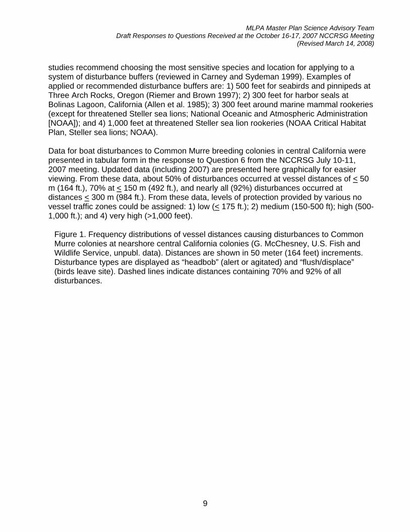
MLPA Master Plan Science Advisory Team Draft Responses to Questions Received at the October 16-17, 2007 NCCRSG Meeting
(Revised March 14, 2008)
9
studies recommend choosing the most sensitive species and location for applying to a system of disturbance buffers (reviewed in Carney and Sydeman 1999). Examples of applied or recommended disturbance buffers are: 1) 500 feet for seabirds and pinnipeds at Three Arch Rocks, Oregon (Riemer and Brown 1997); 2) 300 feet for harbor seals at Bolinas Lagoon, California (Allen et al. 1985); 3) 300 feet around marine mammal rookeries (except for threatened Steller sea lions; National Oceanic and Atmospheric Administration [NOAA]); and 4) 1,000 feet at threatened Steller sea lion rookeries (NOAA Critical Habitat Plan, Steller sea lions; NOAA).
Data for boat disturbances to Common Murre breeding colonies in central California were presented in tabular form in the response to Question 6 from the NCCRSG July 10-11, 2007 meeting. Updated data (including 2007) are presented here graphically for easier viewing. From these data, about 50% of disturbances occurred at vessel distances of < 50 m (164 ft.), 70% at < 150 m (492 ft.), and nearly all (92%) disturbances occurred at distances < 300 m (984 ft.). From these data, levels of protection provided by various no vessel traffic zones could be assigned: 1) low (< 175 ft.); 2) medium (150-500 ft); high (500-1,000 ft.); and 4) very high (>1,000 feet).
Figure 1. Frequency distributions of vessel distances causing disturbances to Common Murre colonies at nearshore central California colonies (G. McChesney, U.S. Fish and Wildlife Service, unpubl. data). Distances are shown in 50 meter (164 feet) increments. Disturbance types are displayed as “headbob” (alert or agitated) and “flush/displace” (birds leave site). Dashed lines indicate distances containing 70% and 92% of all disturbances.

MLPA Master Plan Science Advisory Team Draft Responses to Questions Received at the October 16-17, 2007 NCCRSG Meeting
(Revised March 14, 2008)
10
MLPA Master Plan Science Advisory Team Draft Responses to Questions Received at the October 16-17, 2007 NCCRSG Meeting
(Revised March 14, 2008)
11
Appendix I. Additional rationale and discussion provided by the NCCRSG for considering the species listed in Question 7.
a. Flat abalone, Haliotis walallensis, and Northern abalone, Haliotis kamtschatkana (see
Rogers-Bennett, 2007, Sloan, 2004, and Gladstone, 2002)
Rationale for this is based on the above scientific literature. Both species are under threat because of ocean warming contracting the southern portion of their ranges, the expansion of the sea otters range, and for the flat abalone, a commercial fishery in Oregon. They would also be a good candidate for "flagship" species that would highlight the need for kelp bed community conservation (Sloan, 2004). Gladstone (2002) included them with other mollusks as important indicator assemblages. In the mid- 90s, flat abalone were routinely observed at Saunder's Reef (Lance Morgan, pers. comm., Oct. 2007).
b. White sharks - SAT response to NCCRSG questions (revised Oct 12), "Since little is known about the breeding locations of white sharks, protecting forage species in areas where white sharks aggregate (e.g. the Farallones, Tomales Point) would likely benefit them." The following provides additional rationale and discussion for and against the inclusion of white sharks to the list of species likely to benefit from MPAs. These discussion points were summarized from email discussions among the NCCRSG about this topic.
Discussion and rationale against inclusion of white sharks to the list of species likely to benefit:
1. White sharks are already protected from fishing therefore would not benefit any further.
2. The forage base of white sharks is marine mammals, which are also fully protected.
3. Since little is known about the breeding locations of white sharks any considerations of MPA placement for benefiting white sharks would entail a ‘shotgun’ approach which is unacceptable for all other MPA requirements.
4. The feeding grounds for white sharks are very broad. “They eat whenever and where ever they want” therefore would not benefit from MPAs aimed at protecting forage.
5. There is no need to minimize human disturbance to foraging behavior. Seals have been known to board vessels to escape feeding white sharks. Therefore, white shark feeding behavior is not disturbed by vessel presence.
Discussion and rationale for inclusion of white sharks to the list of species likely to benefit:
1. Although white sharks are protected they would still gain benefit from additional protective designations such as MPAs since interactions with humans may still result in some level of take.

MLPA Master Plan Science Advisory Team Draft Responses to Questions Received at the October 16-17, 2007 NCCRSG Meeting
(Revised March 14, 2008)
12
2. White sharks are internationally recognized as threatened and appear on the IUCN’s red list and in CITES appendices.
3. There are only four places where white sharks congregate in central and north central California. Three of those locations lie in the MLPA North Central Coast Study Region.
4. It has been suggested that research is beginning to show there are limited numbers of white sharks and that some individuals may move between all four sites described above.
5. As apex predators white sharks have small population sizes and are highly susceptible to human disturbance and impacts.
6. White sharks mature late and have low fecundity. 7. The Farallon Islands are an important white shark study area due to location and
low human impact. 8. Allowing take of other organisms increases risks to white sharks. 9. White sharks frequent the same foraging grounds annually, therefore protecting
forage grounds increases protection to white sharks. 10. As an apex predator they promote ecosystem health and can be an indicator
species.
c. Salmonids - SAT response to NCCRSG questions (revised Oct 12), "Placing a protected area in the coastal waters offshore of the river mouth will protect salmon during a crucial life stage." No additional rationale was provided.
California MLPA Master Plan Science Advisory Team Responses to Science Questions Posed at the
November 28, 2007 NCCRSG meeting Revised March 28, 2008
The following are responses of the MLPA Master Plan Science Advisory Team (SAT) to questions posed at the November 28, 2008 meeting of the MLPA North Central Coast Regional Stakeholder Group (NCCRSG). These responses were prepared by work groups of the SAT and MLPA staff, and were adopted by the SAT at its January 23, 2008 meeting. 1. For no disturbance zones for seabird and mammal species likely and most likely to
benefit from marine protected areas (MPAs), what are the seasons that need to be incorporated to protect these species (range of time)? This response was adopted by the SAT at its January 23, 2008 meeting. SAT response: See attached table.
2. What area would encompass the congregation of Chinook salmon at the mouth of
the Russian River, over an average of several years? [Alternatively, could you advise us about whether the areas at the Russian River mouth in two contrasting alternatives, such as Jade B and external option C, are big enough for that purpose?] This response was adopted by the SAT at its January 23, 2008 meeting. SAT response: See responses 8 and 8a from the October 16-17, 2007 set of science questions to the SAT.
3. Will the “hundred penny” studies be used to analyze impacts of various alternatives on commercial and/or sport fishing; if so and if those studies ask fishermen to identify the most important areas they've fished throughout their career, could we also get an overlay of the current rockfish conservation areas on the MPA proposals, to better evaluate what areas would likely have less immediate impact because they include or intersect with areas currently closed? Will analyses using fishing grounds (including the area outside state waters) be available? This response was adopted by the SAT at its January 23, 2008 meeting. SAT response: This question is addressed in the document Draft MLPA Evaluation Methods for MPA Proposals in the section describing socioeconomic evaluations.
4. If “parallel processes” models will be run to compare the different alternatives, will their assumptions and decision rules (a) be transparent to stakeholders and (b) be consistent with SAT guidelines, including levels of protection, so that the model evaluations provide information that's complementary to that provided through the primary evaluation procedures?
This response was adopted by the SAT at its January 23, 2008 meeting.
MLPA Master Plan Science Advisory Team Responses to Science Questions Posed at the November 28, 2007 NCCRSG Meeting
(Revised March 28, 2008)
2
SAT response: Transparency is a key component of the MLPA Initiative process. As such, any models that may be used to complement the evaluation of MPA proposals will include a fact sheet that highlights important parameters, assumptions, and outputs. Additionally, any model used to complement the evaluation of MPA proposals will be just that, complementary information to further inform the evaluation process. The use of models in providing supplemental information is consistent with the guidelines in the MLPA and the master plan for MPAs.

California Marine Life Protection Act InitiativeSeasonality of Sensitive Life Stages of Birds and Mammals Most Likely to Benefit from Marine Protected Areas
Revised December 10, 2007
Seabirds (breeding)
cormorant, Brandt's Phalacrocorax penicillatus
cormorant, double-crested Phalacrocorax auritus
cormorant, pelagic Phalacrocorax pelagicus
guillemot, pigeon Cepphus columba
murre, common Uria aalge
murrelet, marbled Brachyramphus marmoratus Year-round in foraging areas
Seabird (migrant)
brant Branta bernicla
grebe, Western/Clark's
Aechmophorus occidentalis, clarkii
sandpiper, western Calidris mauri
scaup, lesser Aythya affinis
scoter, surf Melanitta perspicillata
willet Catoptrophorus semipalmatus
Marine mammals
porpoise, harbor Phocoena phocena Year-round
sea lion, Steller Eumetopias jubatus Year-round at haulout sites
sea otter, southern Enhydra lutris Year-round in kelp beds with otters (near Half Moon Bay)
seal, harbor Phoca vitulina
Buffers of 1,000 feet at rookeries, haulouts, and foraging areas are recommended during the times indicated with light grey.Protection during the times indicated in dark grey would also benefit the species.Light grey indicate sensitive life stages, primarily breeding/nesting times for resident species and foraging times for migrant species.
Sources: Dr. Sarah Allen, Point Reyes National Seashore and Dr. Gerry McChesney, U.S. Fish & Wildlife Service
Sep Oct Nov DecMay Jun Jul AugJan Feb Mar Apr
California MLPA Master Plan Science Advisory Team Responses to a Science Question Posed at the
December 11-12, 2007 NCCRSG meeting Revised February 15, 2008
The following are responses of the MLPA Master Plan Science Advisory Team (SAT) to a question posed at the December 11-12, 2008 MLPA North Central Coast Regional Stakeholder Group (NCCRSG) meeting. These responses have been prepared by a work group of the SAT and MLPA staff. SAT responses were adopted by the SAT at its January 23, 2008 meeting. 1. What level of protection would a state marine conservation area (SMCA) at the
southeast Farallon Islands receive if that SMCA included the use of a seasonal special closure to protect critical periods for seabirds and marine mammals while allowing uses such as commercial abalone diving during less critical times of the year, noting that the allowed uses would strictly adhere to the frameworks set forth in fishery management plans and the Abalone Recovery Management Plan (ARMP)? Background: Members of the NCCRSG and the public are concerned that a state marine reserve (SMR) at the Farallons would negate the potential for a future commercial abalone fishery at the Farallons. Therefore, they would like to consider designing an SMCA that could incorporate other stakeholder concerns, such as protections for seabirds and marine mammals, while allowing for extractive uses that minimize habitat damage and conform to existing management plans. Note that in one of the draft marine protected area (MPA) proposals a stipulation was inserted that states if through the mechanisms provided in the ARMP a commercial abalone fishery was allowed at the Farallons any MPA would be reexamined for possible allowance of the commercial take of abalone. This response was discussed and adopted by the SAT at its January 23, 2008 meeting. SAT Response: The level of protection assigned to an MPA that allows commercial or recreational abalone harvest is addressed in the DRAFT MLPA Evaluation Methods for MPA Proposals document. An SMCA allowing commercial abalone diving at the southeast Farallon Islands would receive the same level of protection as recreational abalone fishing even if seasonal special closures were in place during critical periods for seabirds and marine mammals. Despite the use of special closures for the protection of seabirds and mammals impacts to subtidal communities would be the same as from recreational abalone harvest thus would not raise the level of protection. Commercial abalone fishing is likely to have a greater impact than that for recreational fishing, due to the use of dive gear and the lack of deep water refugia. a) What provisions are there to ensure that the potential for a future commercial abalone
fishery at the Farallones is not ruled out with the designation of an SMR?
Staff response: Any decision regarding a potential commercial abalone fishery at the Farallon Islands would be discussed as a separate fisheries management decision by the California Fish and Game Commission. If new MPAs are established at the Farallones that prohibit the take of abalone, the commission would have to weigh the options of either
MLPA Master Plan Science Advisory Team Responses to Questions Received at the December 11-12, 2007 NCCRSG meeting
(Revised February 15, 2008)
2
changing those MPAs to allow the take of abalone, or leaving them in place. Concerns regarding potential future abalone diving locations should certainly be raised now, so that they can be considered in the final MPA siting decisions. The California Fish and Game Commission always has the discretion to change an MPA and has done so in other cases to allow commercial fisheries. The commission recently modified the regulations at Dana Point to allow commercial take of lobster. This changed an existing state marine park into a state marine conservation area. Another example of this type of process is found at San Miguel Island. MPAs were established at San Miguel during the abalone fishery moratorium. Those MPAs do not cover the entire historic fishing grounds and the commission is presently engaged in a process to begin consideration of a potential new abalone fishery. While the commission has not indicated whether it will change the MPAs, it has indicated a willingness to receive information on whether a new fishery is warranted. Any future consideration of commercial abalone fishing at the Farallones would follow a similar process.


