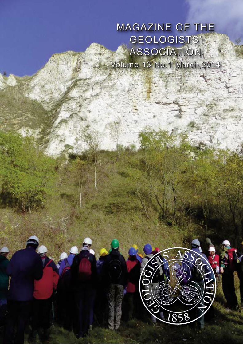
M M M M A A A G G G A A A Z Z Z I I I N N N E E E O O O F F F T T T H H H E E E G G G E E E O O O L L L O O O G G G I I I S S S T T T S S S ’ ’ ’ A A A S S S S S S O O O C C C I I I A A A T T T I I I O O O N N N V V V o o o l l l u u u m m m e e e 1 1 1 3 3 3 N N N o o o . . . 1 1 1 M M M a a a r r r c c c h h h , , , 2 2 2 0 0 0 1 1 1 4 4 4
Production team: LIAM GALLAGHER, John Crocker, JonTrevelyan, John Cosgrove, Roger Dixon, Vanessa Harley.
Printed by City Print, Milton Keynes
The Geologists’ Association
Founded in 1858 The Geologists’ Association serves theinterests of both professional and amateur geologists, as wellas making geology available to a wider public. It is a nationalorganisation based in London, but is represented by local andaffiliated groups around the country. The GA holds monthlylecture meetings, publishes a journal and geological guidesand organises field excursions both in the UK and abroad.Subscriptions are renewed annually on November 1. You can join the GA on-line on our website:
Maybe the winter is the time of year when GA membershave time to reflect on issues and make more use of ourinformation systems including the website. I have had severalcomments from you which we are addressing including tomake sure our website is kept up-to-date. I hope you will feelthese issues have now been addressed and we have askedone of our vice presidents to take on the task of continuouslymonitoring our website to make sure it is functioningproperly. Keep your comments coming as they are veryuseful and constructive. For those who do not use our websitethe information on our talks, field meetings, conferences, theFestival of Geology and our annual groups meeting eachNovember is given in the GA Magazine and the GA greenmembership card. If you feel you havemissed out on information please let usknow. It is also now possible to pay forfield trips through the website.
I have also been very pleased toreceive comments relating to how werecognise those who have beenmembers of the GA for 50 years ormore. At our February Council Meetingwe decided to list in our Annual Reportthe names of all those members whohave reached 50 years or morecontinuous membership of the GA. Infuture years we will list just thosemembers who reach the 50th yearduring the year reported and will wewill design a special certificate to besigned by the President to be sent toall those making this landmark lengthof Membership.
Several of you have also contactedme about how we deal with obituaries as you feel some GAmembers have not received an obituary when they shouldhave. The current position is that we rely on you to tell uswhen you know about a GA memberwho has died and we then seeksomeone to write an obituary whichmay be published either in the GAMagazine or the Proceedings of theGeologists’ Association. Findingsomeone to write an obituary has notalways proved easy or successful. Wehave, therefore, decided at theFebruary Council Meeting, that we willin future announce all deaths of GAmembers in the Magazine as soon aswe know about them and identify those for whom we need anobituarist. I hope you feel that this has addressed some ofyour concerns. We still rely on you to tell us by sending to theGA office the name and as much detail as you can aboutthose GA members who have died.
We have had increasing requests to support regionalactivities either through the funds we make available formeetings or requests to the Curry Fund. We also help
advertise your events to a national audience through the GAMagazine and recently we made a decision to devote a pageon our website to other geological events (under Events) witha link from the home page for the most immediate. Our roleis ‘pump-priming’ and we give greatest support to thoseactivities that bring more than one group together. To be fairand even-handed to all our groups, once an event hasbecome successful and self-financing we reduce ourinvolvement but continue support through advertising etc.and focus our efforts on other groups who are getting newinitiatives going. I am delighted to see the great success ofinitiatives such as the Oxford Geology Group’s Colloquiumand we look forward to many more initiatives that we can
help with from other groups. We arealso looking for ways in which you canhelp us as it has to be a two-wayprocess to make sure both local groupsand the GA continue to be successful. Congratulations to Susan Brown for
obtaining renewed sponsorship forRockwatch from Statoil and newsponsorship from the UK OnshoreGeophysical Library.
Virtual geology was the theme of ourtalks in December and January. MarkSutton showed us the benefits of the‘synchotron’ as a tool for investigatingand reconstructing detailedpalaeontology, including soft parts offossils. This was followed by IanWatkinson’s amazing array of GoogleEarth images of structural geologyfrom around the globe. Both talksillustrated wonderful new observations
in their particular subjects, though most felt the techniqueswere a great complement to rather than a replacement of‘real’ field geology. The complete cyber-armchair for geology
is not quite here yet!A big thank you to the Dorset GA for
the invitation to their AGM and AnnualDinner in Dorchester in December. Itwas another excellent evening andthanks to Alan Holiday for looking afterme in Weymouth. In the theme ofgiving talks and spreading the wordabout the GA it was good to seeseveral GA members listening to yetanother Chalk-Talk to the HomeCounties North Group of the Geological
Society on 21st January at Burlington House.I am delighted to see that we had 26 new GA members to
record at our February meeting and many of these were fromengineering geology. As an engineering geologist I havegained enormous benefit from being a GA member. We havedecided to publish the names of all new members in the GAMagazine as part of our welcome to them.
FROM THE PRESIDENT: Professor Rory Mortimore
Magazine of the Geologists’ Association Vol. 13, No.1 2014
Dr Al Bian
3
Thanks to those who have written with nominations for theHalstead Award and new Council members. The results willbe announced at the Annual General Meeting on May 9th
when the recipients will receive their awards. Please note thatthe AGM this year will begin at 6.30 (tea 6.00 pm) on thesecond Friday in May to allow those who are involved with theLyme Regis Festival to attend both events. We will hold theAGM dinner in the Lower Library after the meeting. The costof the this year will be £35. Please finddetails, including how to pay on page 8.
As in recent years we will send the Annual Reportelectronically to those for whom we have emails. Theelectronic version will contain colour photographs and be amore attractive document than the printed version. Pleasesend your email address to Sarah Stafford if you think shemay not have it or if your email address has changedrecently. If you are on email but would still rather receive apaper copy please let Sarah know. We will include notificationof the 2014/15 password with both the paper copy andelectronic copy of the Annual Report. It will change on 9th
May, the AGM day. This will enable access to the Members’page on the website where videos of most of the past GAtalks are now available to members.
By the time this issue of the Magazine arrives, membersshould have received a copy of the Wyley History of theGeologists’ Association either as paper copy or electronicallyfor those who requested it. If, for any reason, you have notreceived your copy, please get in touch with the office.
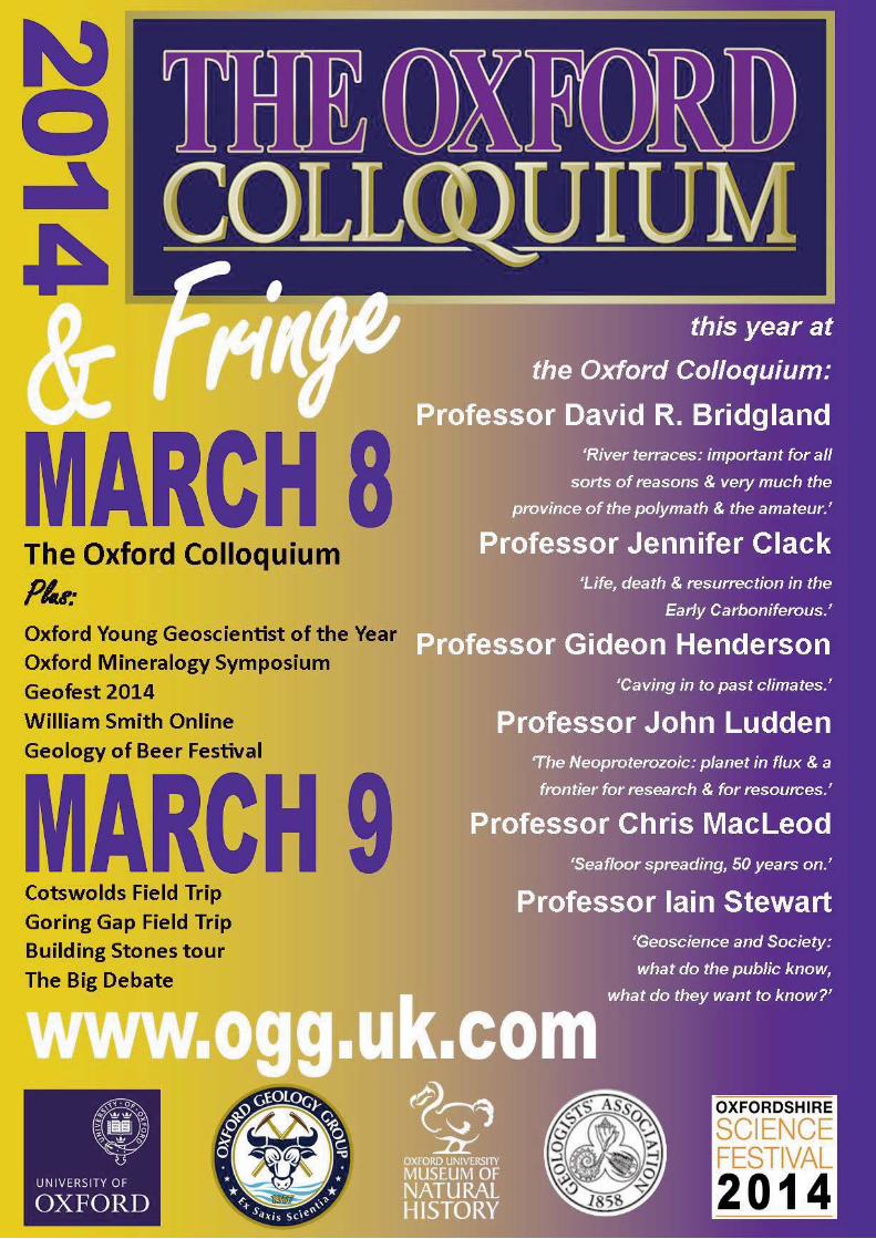
There are a number of large events coming up this year. TheGA is again supporting the Oxford Colloquium organised bythe Oxford Geology Group which will take place in theUniversity of Oxford Museum on 8th March (see back coverfor details). Please also see advertisement on page 26 for theWoodward150 conference at the Natural History Museum on21st May. On the weekend 2nd - 4th May Rockwatch and theGA will have a presence at the Lyme Regis Fossil Festival. Thisyear’s topic is The GA is promoting 2conferences this year (details on pages 5 & 6). The first is ajoint venture with the Geological Society and the Society ofAntiquaries and is titled
A day of lectures in Burlington House on 16th
May is followed by a day in the field in Hertfordshire and 2days in northern France. The 2014 GA/Elsevier Conference:
will beheld in Leicester on 5-7th September. The GA Festival falls on1st/2nd November this year. The full list of GA UK andoverseas field meetings for 2014 can be found in the Circular,on pages 20-24. These include a number of weekend tripsthis year and we look forward to your registrations. One ofthe changes to the rules last July is that new members are nolonger elected at the monthly lecture meetings. However, wehave had a request from a GA member asking us to publishthe names in the GA Magazine. In this edition we are listingthe new members since July 2013; In future we will list thenames of those that joined during the previous 3 months.
REPORT FROM COUNCIL: Diana Clements, General Secretary
Peter Adamson Peter Anderton Elizabeth Aston Penelope Badham Steven Bates Marilyn BesfordLarry Bottomley Dexter Brown Ian Candy Adam Carr Michael Carter Geoffrey CarverRobert Chapman Steve Chittick Steven Clegg Robert Cooke William Cooper Chas CowieBill Dalzell Adam Desai Julie Dore Stephen Fisk Scot Francis Richard GhailPaul Gibbs Vic Gibling Melanie Green Anthony Hayes Carol Janet Horn Matthew HowardKelvin Huff Elizabeth Hurst Shahzaib Jamaldini Zuratul Anne KaniRhian Kendall Adrian King Monika Knul Veronica Lane Amy Lawrence David LawrenceDouglas Lester Tom Martin Satvinder Nandhra Douglas Nelson Ralph NicholsJean Notley Sarah-Jane O'Shea Karoly Pesztranszki Pam Pettman Jennifer RhodesOighrig Rieder Stuart Robinson John Scott Chris Sondermann Arthur Tingley Colin TurnerThomas Vandyk Alex Wade Merryl Wallace John Wardle Kevin Wells
Neil Adams Don Aldiss Robert Ashford Gina Barnes Nick Barraud Matthew BellhouseJoann Blows Jennifer Brzozowska Nick Church Victoria CorcoranFrank de Charro Anjana Ford Anna Giangiordano Terence Hackwill David Hughes Peter JacksonJames Jackson Ian Kenyon Alexandru Lapadat Jake Morton Joseph Piggott Andrew RaceyJacqueline Ratner Brian Redfearn Jennifer Smith Vivian Stevens David Robert Wallis
Magazine of the Geologists’ Association Vol. 13, No.1 20144
During the past three months we have been made aware of, and are sad to announce, the deaths of the following members: Dr Geoffrey Arthur Kellaway Dr Frank Alexander Middlemiss (obiturist identified) Mrs Avril Phyllis ThwaiteWe are always receptive to publishing short obituaries and/or a photograph so if you feel you would like to write one, please getin touch with the office.
Magazine of the Geologists’ Association Vol. 13, No.1 2014 5
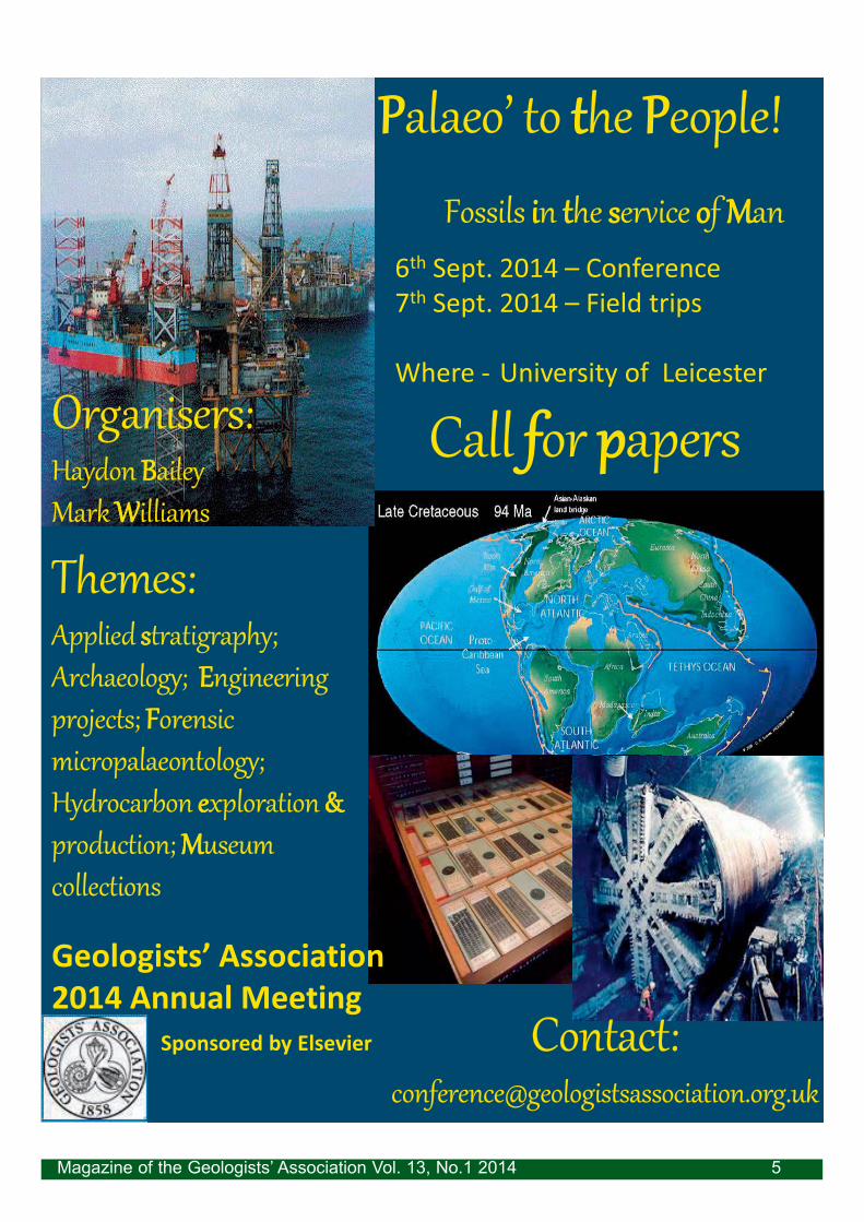
PPalaeo to tthe PPeople!
Fossils iin tthe sservice oof MMan
6th Sept. 2014 Conference7th Sept. 2014 Field trips
Magazine of the Geologists’ Association Vol. 13, No.1 20146
Puddingstone and relatedsilcretes of the Anglo-Paris Basingeological and archaeological perspectives
Burlington House, London, UK
A joint meeting of the Geological Society, the Geologists Association and the Society of Antiquaries
16-19 May 2014
Conveners: Jenny Huggett (Petroclays)
Chris Green (Society of Antiquaries)
Rory Mortimore(Geologists Association)
Hertfordshire Puddingstone and its regional counterparts havelong been of interest to both geologists and archaeologists,while recent developments in the understanding of modernsilcrete and recent petrographic and stable isotope studies ofthe puddingstone silica cements are providing new insightsinto the origin of puddingstone. Even though HertfordshirePuddingstone is a remarkably tough rock, it has been found inplace in only a few locations. In contrast, puddingstone that hasbeen moved and used by humankind is much more common. Inparticular, Roman puddingstone querns are found over a widearea and are of particular interest to archaeologists. In the lastsix years there has been growing cooperation betweengeologists and archaeologists on puddingstones studies, toinvestigate both the Hertfordshire Roman puddingstone quarryand to look further afield. In 2011 a second Romanpuddingstone quarry was found in Northern France, in an areaof the Paris Basin that includes fossiliferous Paleogenepuddingstone. The meeting will cover puddingstones andsilcretes of similar age in both the Hampshire and Paris Basins,and the weekend field trip will include East Hertfordshire/Essex, then Saint-Saëns and Sotteville in Northern France. It isanticipated that both the meeting and the post-conferencefield trips will lead to further co-operative research betweenarchaeologists and geologists.
Speakers include:Bryan Lovell, David Nash, Mike Parker Pearson, Jane Tubb, Chris Green, Jenny Huggett, Tony Brown
For further information please contact:Georgina Worrall, The Geological Society, Burlington House, Piccadilly, London W1J 0BG
Axel Cronstedt coined the name for these newly found
minerals ( is a Greek word meaning ), he
could not know that it would take two centuries for these
materials to demonstrate and realise their potential. But
when it did happen in the second half of the 20th century,
their success was overwhelming. Largely unknown to the
general public, zeolites have become essential for a host of
major industrial developments, and scientific studies into
zeolite science have increased dramatically over recent
decades, reflecting the growing understanding and
application of these versatile materials. It is estimated that 5
million tons of natural zeolites are mined and 2 million tons
of synthetic zeolites are
produced annually.
Thanks to the unique
combination of their
exceptional properties,
zeolites are utilised as
molecular sieves and
sponges, as nuclear waste
clean up materials and as
water softeners in
washing powders, as well
as essential catalysts in oil refining for the production of
petrol and diesel and in petrochemical industries making
plastics and synthetic fibres.
This presentation aims to give a brief overview of zeolite
science and practice, as well as to demonstrate the natural
beauty of zeolite structures and their remarkable properties.
April Meeting:April Meeting: April 4th, 2014April 4th, 2014
Zeolites - just boiling stones?Zeolites - just boiling stones? Vladimir ZholobenkoVladimir Zholobenko
May Meeting and ANNUAL GENERAL MEETING:May Meeting and ANNUAL GENERAL MEETING: May 9th, 2014May 9th, 2014
PRESIDENTIAL ADDRESS: A walk on the Chalk side Part 2: PRESIDENTIAL ADDRESS: A walk on the Chalk side Part 2: The magic of Flint; a never ending storyThe magic of Flint; a never ending story Prof. Rory MortimoreProf. Rory Mortimore
Flint is inextricably interlinked with
chalk in many parts of the World
including North West Europe.
Continuing last year’s theme of trying
to answer the seemingly simplest yet
most difficult questions relating to the
origin of Chalk this year’s talk
illustrates the role of flint in helping to
unravel some of these mysteries. In
this quest some the topics to be
covered include:
1. Nature of flint in bedding. What
controls the apparently ‘cyclic’
recurrence of flint bands?
2. Recurrence of types of flint and do
these reflect large-scale sedimentary
cycles?
3. Some remarkable flint bands (Criel
Paramoudras, Lewes Tubulars, Cuilfail
Zoophycos, Seven Sisters Semi
Tabular).
4. Preservation of fossils (uncrushed)
trace fossils (unsquashed), and early
fractures illustrate the early onset of
flint formation.
5. Correlation of flint bands and flint types (long distance –
thousands of kilometres). How do we identify the same flint
band in widely separated areas?
6. Distribution of flint and
basin analysis (shelf to deep-
water). What controls the
absence of flint in some areas
and lots of flint bands in other
areas?
7. Fragmented flints such as
the ‘Mish-Mash’ Flints and the
flints of Etretat and Hope Gap
occur in bedding plane slips and
in slump bedding. How can
strong flints fragment in very
weak, soft chalks?
8. In areas where intra-chalk
reworking has occurred flints
are absent. What happens to the
host sediment to prevent flint
formation.
9. Flints as a pain in the
tunnel face.
10. Flints as impermeable
water flow horizons and the
development of cave systems.
Flint bands continue into the youngest Maastrichtian chalk
of Norfolk and Northern Ireland and siliceous chalks and
reworked flints are a feature of end Cretaceous deposits of
the Inner Hebrides.
Magazine of the Geologists’ Association Vol. 13, No.1 2014 7
Madagascar is one of the largest islands in the world and,
as a result of both its isolation and geological history, is home
to a diverse and unusual collection of animals and plants. The
extant frog fauna of the island is exceptionally rich and
almost completely endemic. Understanding of the history and
relationships of these frogs has been greatly advanced by
molecular studies, but very little is known of their fossil
history. Until recently, the fossil record of frogs on
Madagascar was limited to a single specimen of the Early
Triassic proto-frog, Triadobatrachus. However, over several
decades, palaeontologists from Stony Brook University, New
York, have led field work in the Upper Cretaceous
(Maastrichtian) rocks of the Mahajunga Basin in the north
west of the island.
These deposits have produced a diverse fossil assemblage
including dinosaurs, crocodiles, turtles, rare lizard remains,
mammals and primitive birds. In 2008, we named the first
fossil frog from the deposit, based on a small collection of
distinctive skull fragments. The large size, heavy
ornamentation, and inferred predatory nature of this frog led
us to name it Beelzebufo. Beelzebub, lords of the flies,
seemed rather appropriate. More recently, new material of
the skull and postcranial skeleton has shown Beelzebufo to
have been even more bizarre than we originally interpreted.
Various features of its anatomy, including the absence of an
eardrum, suggest it may have survived periods of seasonal
to place it with South American ceratophryid (‘Pacman’) frogs
rather than African ones, posing something of a
palaeobiogeographical conundrum.
June Meeting: June Meeting: June 6th, 2014June 6th, 2014
Big, bad and bizarre, the devil frog from the Late Cretaceous Big, bad and bizarre, the devil frog from the Late Cretaceous of Madagascarof Madagascar Susan E. EvansSusan E. Evans
Magazine of the Geologists’ Association Vol. 13, No.1 20148
GEOLOGISTS’ ASSOCIATION ANNUAL DINNER FRIDAY 9TH MAY 2014
Join us for the GA annual dinner which takes place in the historic surroundings of the Lower Library of the Geological Society. It will be held after the AGM and Professor Rory Mortimore’s final Presidential Address.
The cost is £35 per person, which includes a sherry reception, and a two course hot buffet. Book now either by phone (020 7434 9298), or email [email protected].
Please make cheques payable to “Geologists’ Association”.
Last year as the increasingly polarized fracking debateflared up, the British Geological Survey released a wellillustrated report on the Carboniferous shale gas potential ofnorthern England. (It can be freely downloaded athttps://www.gov.uk/ government/publications/bowland-shale-gas-study). This appraisal received widespread mediacoverage with maps clearly showing readers the separatedistribution of the Upper and LowerBowland shales across much ofLancashire, Cheshire Basin andlarge parts of Yorkshire (theBowland-Hodder unit, depositedduring the Visean and Namurianepochs in a series of sedimentarybasins). This assessment estimated1,300 trillion cubic feet (37.6 trillioncubic metres, within a range of 23.3to 64.6) of shale gas may lietrapped within the Upper and LowerBowland shales buried at least1,500m below ground, the depthnormally required to provideenough overlying pressure to allowfor successful extraction in theU.S.A., of which around a tenthmay be recoverable reserves.
Another BGS report about theJurassic sediments of the Wealdbasin between London, Hampshireand the Sussex coast is due out. Inthe meantime the focus has shiftedfrom the original fracking-inducedquakes near Blackpool in 2011 toprotests last summer at Balcombein West Sussex, where the samecompany, Cuadrilla, was drillingat an old well site where possible reserves might fail to flowby conventional methods. At that stage work would have tostop while an application was made to permit fracking to goahead. All this endless fuss diverts attention from makingcarbon capture and storage (which can also trigger smallearth tremors) a technically viable solution for generatingelectricity from hydrocarbons without exacerbating futureglobal warming, while at first enhancing oil recovery fromunder the North Sea (Geology Today 2009, v.25, p.49).Indeed, Zoe Williams commenting in the Guardian (15August,
) pointed out how these wider issues are complex andnot a case of obvious binary choices between fracking anddecarbonisation. Government policy needs to consolidate amove from coal to gas without undue faith in fracking killingoff investment in renewables. As she also pointed out, allenergy production, including windfarms, causedenvironmental damage, and she wrote most tellingly:
This BGS report draws on memoirs written to describesheets in the 1:50,000 geological map series, including keyPennine sheets with extensive three-dimensional outcrops ofthese classic formations, plus a more recent series of
subsurface memoirs drawing onseismic reflection surveys andother geophysical data coupledwith discrete borehole data. Thesewere written long before the latestwave of early retirements andredundancies meant that theBritish Geological Survey (whosepension liabilities don’t counttowards its annual budget) lost itscapacity to undertake rigorous anddetailed systematic surveys.
While the Natural EnvironmentResearch Council might notconsider this to be of much merit,without such mundane work thehole in the ozone layer would nothave been spotted by the BritishAntarctic Survey making routinereadings questioning the satellitedata: NASA had been filtering offlow ozone readings, assumingthey were in error! Soon, as aresult of NERC and governmentpolicy, the BGS will lack enoughstaff with the hands-on knowledgeand diverse experience tomaintain its integrity as a keysource of impartial andtrustworthy information with thecapacity to rapidly undertake
independent assessments including fresh fieldwork. The BGShas a wider custodianship and advisory role beyondconducting narrowly defined research, so that it needs tomaintain a breadth of often at first sight esoteric expertise,as for example when volcanic ash closed down much ofwestern European airspace in 2010.
Furthermore, if shale gas extraction does take off, extrastaff will be needed at all stages of the process includinginterpreting newly acquired data, if wider public confidence isto be maintained. This is not helped by trespassing on privateland while conducting seismic surveys being misreported as
(Guardian, 2 August 2013). I pitystudents undertaking fieldwork having to explain thedifference to an irate landowner when they simply wantpermission to walk around mapping. Such paranoia will befurther fuelled by reports that
Opinion ArticleOpinion Article
Shale gas potential under Northern EnglandShale gas potential under Northern England David A. G. NowellDavid A. G. Nowell
Magazine of the Geologists’ Association Vol. 13, No.1 2014 9
in the Guardian (18 December 2013),based on a Department of Energy and Climate Change“Strategic Environmental Assessment for Further Onshore Oiland Gas Licensing” consultation (debunked by the CarbonBrief blog http://www.carbonbrief.org/blog/2012/12/how-much-shale-gas-has-the-uk-got/). Though other mediaoutlets opted for around half, they all ignored the fact thatthis included existing conventional oil and gas blocks (basedon the OS 10 km grid – so peripheral areas were added to thegrand total), and even rather limited virgin coalbed methanein addition to unconventional shale gas and oil. Given that theconsultation includes all other significant areas, the omissionof the Oxfordshire coalfield beneath David Cameron’s Witneyconstituency is rather an odd coincidence. Back in 1960-61,when the geological survey was able to occasionally drillboreholes nearly a mile deep, 20 coal seams over 45 cm thickwere logged at Apley Barn just outside the town (Bulletin ofthe Geological Survey of Great Britain No. 29, HMSO 1969).Since then, successive cuts to its core funding mean that westill know relatively little about the basement geology ofareas without any hydrocarbon potential like Hertfordshireand Suffolk - areas which might be a suitable locality for anuclear waste repository beneath an impermeable Gault Clayseal. Furthermore, this report asks for views on the surfaceimpact of drilling sites, without considering areas lackingmodern geological mapping with which to effectively assessin an impartial manner risks such as ground water pollutionand flooding.
Unfortunately, almost everybody has seen the clip of flamingtap-water from the polemic 2010 documentary Gasland,which fails to mention that methane has been a well knownhazard in water wells for many decades. Geochemical testswould be required to show its source - including rottinglandfill, coal mining, and conventional oil and gas exploration.However, it is rather unhelpful when a report on
(9 September 2013), co-authored byDavid MacKay FRS, the Department of Energy and ClimateChange's chief scientific adviser, compared mildly radioactivewaste water to bananas on page 16: one 15,000 tonne flushcould easily yield the equivalent of between 15 and 90 millionbananas. Unlike rotten fruit, water can easily evaporate andflow, and geochemical reactions including differentialbiological uptake pathways and environmental concentrationor dispersal of toxic chemical compounds are a highlycomplex matter, not to be brushed off so lightly.
The quakes generated by experimental drilling nearBlackpool, Lancashire, measuring 2.3 and 1.5 in April andMay 2011, were small even compared to the ones generatedby longwall mining: Stoke-on-Trent experienced a magnitude3.3 event in 1980. Former coalfields continue to get minortremors as old mine workings slowly subside. Due toreservoir compaction causing faulting above gas extraction inthe northeast Netherlands, the Groningen area isexperiencing increasingly significant tremors, including a 3.4event in August 2012 at a depth of around 3 km. A follow-upstudy showed a correlation between seismicity andproduction with future magnitudes below 5, given that thesimilar Rotenburg gas field in Northern Germany had a 4.4
quake in October 2004, while the Lac gas field experiencedlocal magnitudes up to 4.2 in the vicinity of the FrenchPyrenees. Roughly once a decade Britain can expect arelatively small magnitude 5 earthquake with lethal potential:earthquakes are measured on a logarithmic scale, so that,while the amount by which the ground shakes goes up tentimes for each whole number (the Richter scale isobsolescent), the amount of energy released goes up byaround 32 times. In this context for the media to go on aboutearthquakes rather than tremors is frankly insulting to thevictims of these really tragic disasters.
Friends of the Earth rightly question the economics andworry about the overall environmental impact of fracking -including methane leakage from poorly constructed wells, asthis is a far more potent greenhouse gas than carbon dioxide.Given this, the BGS have been sampling ground and streamwaters to establish natural methane levels to monitor futurefracking operations. However, I feel environmental groupswould be far more credible if they focused on our profligateuse of resources, including complex discounts for multiplepurchases so more food ends up being thrown away. Larger schools mean longer average journeys, and a lack of
suitable housing has resulted in greater commutingdistances. Last year a local pub was refurbished andextended without planning permission requiring doubleglazing for a nondescript cold and draughty building. Unlikecampaigns against corporate tax avoidance, nobody picketsshops whose head offices insist on them keeping their doorswide open during winter. Like legislation banning smokingindoors, statutory regulation would provide a level playingfield: it must be hard for children to take lessons aboutclimate change seriously when they see such gratuitouswaste in their everyday lives. Many live in cold homes, poorlyinsulated and maintained: European countries with a similarclimate use far less energy (
, The Guardian 29November 2013). Less than half the energy is used heating atypical pre-1920 detached house in Germany, while inSweden it is only a third. Homes built in the 1980s comparejust as badly, and the specialist report highlighted poorworkmanship being a key barrier to home improvements inBritain, where builders do not have to have legally recognizedprofessional qualifications and anybody can call themselvesan engineer.
Unlike the demise of deep coalmining, these days the Britishgovernment appears to be more worried about our balance ofpayments and energy security, to the point of reducing taxrates while repeating the mistakes of North Sea oil and gastaxation: our neighbours have tax escalators so that windfallprofits due to increases in global energy prices are fairlydistributed. However, the consultation suggest localcommunities should be paid £100,000 and one per cent ofany revenues for each well-site, but it is unclear how this willbe distributed: parishes are too small and district councilsrather too large to compensate those facing the mostdisruption, while payments could sway councillors voting inthe planning process. While the Daily Telegraph quotedProfessor Peter Styles, at Keele University, about howfracking has been used over the last couple of decades to
Magazine of the Geologists’ Association Vol. 13, No.1 201410
recover oil and gas from onshore wells in Britain includingWytch Farm in Dorset (10 August 2013,
), these well-stimulation techniques are naturally different: conventionalreservoirs are porous and usually consist of permeablesediments like sandstones, while shales are impermeableclays which have been mildly baked by shallow burial andheating after their deposition. It would thus be helpful todistinguish between permeable and impermeable fracking:flushing out conventional hydrocarbons by pumping in waterusing “permeable fracking” is a technically distinct process.Clays and shales are normally considered to be aquicludeswhich act as impermeable layers between aquifers so that ifit is done correctly “impermeable fracking” of shales byinjecting sand to open up cracks to yield gas should pose norisk to our usual water supplies unless the well casingtowards the surface is breached.
There is a real danger that potential site selection will notbe guided by geological considerations to minimize the risksfrom surface spills. Local ground conditions can make it muchharder to contain pollution incidents than in locations withrelatively impermeable soils. While some areas are coveredby state of the art 1:50,000 sheets based on fresh 1:10,000
geological mapping, the coast from Bootle to Fleetwood(mantled with peat and other often vulnerable superficialdeposits) has only outdated (sometimes basically Victorian)surveys. The same goes for much of Cheshire and Yorkshireunderlain by these shales at suitable depths. Furthermore,for the lack of a few million pounds a year to continuesystematic geological mapping, with a third of Britain still notcovered by anything approaching modern standards, futuregovernments will continue to make expensive planningmistakes. Unforeseen ground conditions are used as anexcuse for inadequate site investigations, and unlike ourarchaeological heritage temporary sections do not have to berecorded to increase our overall knowledge about localground conditions. Nor, when it comes to the long-termdisposal of high-level nuclear waste, has the BGS over recentdecades been funded to explore in depth geologically stableareas with no foreseeable deep potential mineral resources.Shale gas exploration will only increase this imbalance in ourknowledge about the underlying geology of Britain. Indeed,the Bowland Shale pops up in places along the bottom of the2 km deep cross-sections on the new 1:50,000 bedrockgeology map of Wigan (Sheet 84), below the very coalmeasures which fuelled the Industrial Revolution upon whichBritain’s industrial wealth was originally built.
Magazine of the Geologists’ Association Vol. 13, No.1 2014 11
GA COUNCIL AND COMMITTEES
Officers: President: Professor Rory Mortimore; [email protected] Vice-President: Dr Haydon Bailey; Vice Presidents: Dr Colin Prosser, Miss Leanne Hughes; Treasurer: Dr Graham Williams; General Secretary: Mrs Diana Clements.
Postholders: Minutes Secretary: Mr Roger Le Voir; Meetings Secretary: Dr Michael Oates; Field Meetings Secretary: Mr Geoff Swann; [email protected] Field Meetings Secretary: Dr Michael Ridd; Guides Editor: Professor Susan Marriott; GA Magazine representatives: Dr Liam Gallagher, [email protected]
Professor John Cosgrove;Earth Heritage Representative: Professor David Bridgland; GA Archivist: Dr Jonathan Larwood; Librarian: Miss Elaine Bimpson/Mr Paul Winrow; Awards Panel Secretary: Mrs Barbara Cumbers; [email protected] Team Chairman: Dr Paul Olver; Rockwatch Chairman: Mrs Susan Brown; [email protected]
Non-Council Postholders: Proceedings Editor: Professor Jim Rose. Executive Secretary: Sarah Stafford; [email protected]
Ordinary Members of Council: Mr Anthony Brook, Ms Nikki Edwards, Professor Richard Howarth, Dr Peter Riches.
Members of Council retiring May 2014: Miss Elaine Bimpson, Professor Richard Howarth, Dr Michael Ridd, Dr Peter Riches
The ‘Geology of the Borderlais’ (perhaps more memorablefor the wine-tasting) was led by Prof. Jean-Pierre Tastet(University of Bordeaux), ably assisted by his friend andcolleague Prof. Graham Evans (University of Southampton).Jean-Pierre has a lifetime experience of Bordeaux geologyand has also investigated the local geology and soil types formany of the region’s château (as the vineyards are known)(Fig. 1). The Bordeaux area and Gironde valley ischaracterised by Quaternary fluvial terraces with sedimentarysequences that relate to differential erosion of the Alpine
rocks in the headwaters of the river catchment. We wereshown, with frequent tastings of the wines, how the riverterraces are subtly or sometimes significantly different fromthe others, creating a range of ‘terroir’ for different grapevarieties.Our group of 17 stayed in a small Apart-hotel in a somewhat
run-down area on the edge of Bordeaux, within walkingdistance of the town centre but needing the carefulnegotiation of water-pipe replacement works and frequentdeposits of the canine variety. What the hotel lacked wasmade up for in the quality of the excursions, meals and wine-tastings although details of which château we visited onwhich day is now a faded memory (Fig. 2). Memorable mealsincluded a two and a half hour lunch with unlimited wine, apicnic in the pine forest (with plenty of wine...), and thepicnic in the château on the last day during a brief rainshower.
Vineyard visits were excellent; from the small family-runchâteau to the large commercial names. All wereaccompanied by a look at the range of soil types, a tour ofthe production process and the cellars, followed by wine-tastings and a challenge to identify the soil on which the vineswere grown. Probably the general consensus was that theeffect of the geology, principally limestone or chert/flint soils,was detectable but became less obvious with increasingtechnical input in the wine-making process. We didn’t get to
taste the old vintage wines that we saw in some of the cellarsbut Jean-Pierre had arranged a climax to the trip for us –more about our last day later.Apart from looking at vineyards and soils, we made visits to
the dramatic Atlantic coastline south of the Gironde estuary(Fig. 3). Here, the long-shore drift has created a distinctivenorth-south more or less straight coastline with sand dunes,now mostly stabilised by being forested in the Napoleonicperiod. The crescent shapes of the sand dunes can still beseen in the landscape and we were given a fascinating
explanation of their formation. The mobility of this coast wasclearly seen in modern attempts at preventing coastal erosion(some partly successful), the mid-11th century church atSoulac (excavated from beneath encroaching dunes) and thestunning 80 metre-high dune at Dune du Pilat with slopesdropping majestically to the beach, especially when set
FIELD MEETING REPORT: FIELD MEETING REPORT: Geology of the Borderlais, Bordeaux, FranceGeology of the Borderlais, Bordeaux, France May, 2013May, 2013
Leader: Prof. Jean-Pierre TastetLeader: Prof. Jean-Pierre Tastet Reporter & Photo’s: David & Anne BoneReporter & Photo’s: David & Anne Bone
Magazine of the Geologists’ Association Vol. 13, No.1 201412
Magazine of the Geologists’ Association Vol. 13, No.1 2014
against threatening dark skies (Fig. 4). Wind erosion of theseaward side has revealed layers of carbonaceous debris,former soil horizons engulfed by the migrating dune system,complete with fragments of ancient pottery.
We also stopped on the shore of Étang de Cazaux et deSanguinet, a large freshwater lake trapped inland of thecoastal dunes. Originally a tidal inlet, the encroaching dunesgradually blocked off the outlet to the sea some 6,000 yearsago. The slowly increasing water depth of the lake floodedsites dating from the Bronze Age to the Roman period –including settlements, iron working sites and numerous longboats. Underwater excavations by local amateurarchaeologists have revealed a fascinating history of thearea, well illustrated in the volunteer-run museum atSanguinet. A visit to the ruins of the Gallo-Roman town atBrion, now a deserted archaeological site remote from anywater access, also demonstrated the changing nature of thelowlands around the coast and the Gironde river as a resultof sediment accumulation in historic times.
Heading east from Bordeaux, we visited a number ofvineyards on our way to the region of Saint-Emilion. By thistime, we had got used to the never-ending vista of vines butthe monoculture landscape was still impressive; visions ofsouth-east England after global warming? After a tour of theunderground stone quarries that now serve as wine cellars at
Clos Fourtet (Fig. 5) we spent a free afternoon in the historictown centre of Saint-Emilion. Picturesque in the sunlight withits historic church, old buildings and cobbled streets with wineshops on every corner, it was yet another opportunity topurchase bargain-price wine (assuming you hadn’t alreadyspent your money on an expensive beer or cup of coffee!).
By the last day, we managed to taste our way through 10different wines (two of which came in unlimited supply duringthe picnic lunch). We were in the Sauterne region with the
first tasting at Chateau Peyrot at around 10.00 but theafternoon culminated with a visit to the top-class vineyard ofChateau d’Yquem. After the usual tour, we were treated tothe rich sweetness of noble rot Sauterne at the heady priceof €700 a bottle (Fig. 6). We didn’t buy any but it was rather
nice! The unusual climax was saying goodbye to Clibert, ourable, congenial and ‘can’t drink because I’m driving’ coachdriver. Not only did we send him home with a handsome tipbut also with a Clingfilm covered plastic beaker, half-filledwith probably €30 worth of Chateau d’Yquem.An excellent trip, only made possible by our host Jean-Pierre
and his contacts in the various châteaux and a life-timeexperience of working on the geology of the Bordeaux area.Thanks to Graham for persuading him to run this trip.
13
We prefer to send you an electronic copy of the Annual Report which will contain colour photographs. If you would prefer a
printed copy in black and white, please contact Sarah on 020 7434 9298 or email [email protected]
If you think the office may not have your current email address, do please send it.
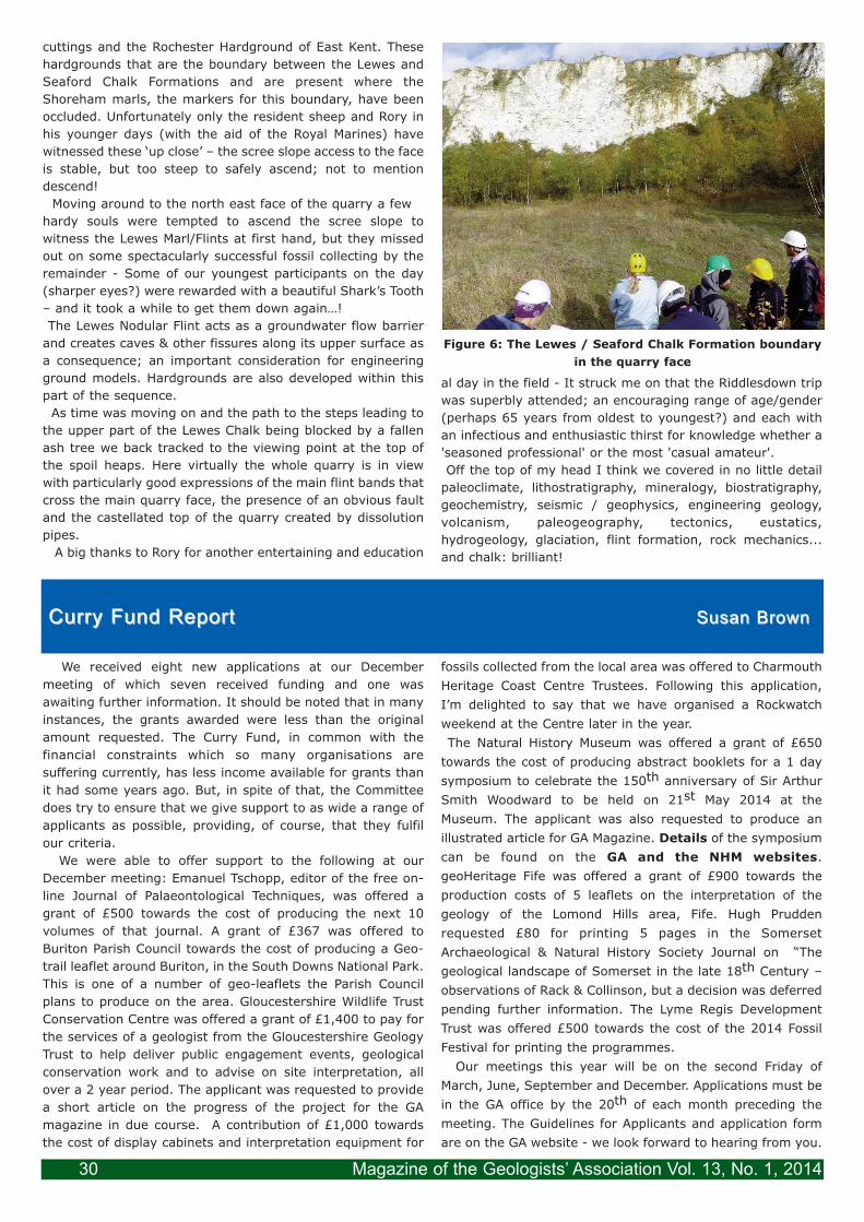
As with every field trip led by Rory Mortimore we knew thatthis weekend was going to be an inquiry into the known andthe unknown of the Yorkshire Chalk and, as ever, would begiven with his undimmed enthusiasm and generosity. Both inthe field and in the bar Rory gave us a guided insight intomillions of years of marine ecology, the processes during theCretaceous that led to the formation of the Chalk, the tectonicinfluences that the Chalk was subjected to and when. Wealso learnt about the evidence for that tectonism; the long-term and large scale events such as major faults and volcaniceruptions as well as the short-term and local events likeunderwater avalanches and sliding beds. Rory wove a picturegained from over three decades of work on the Chalk. Fromthe number that joined us for the weekend I think we can layto rest the easy quip that Chalk is boring: that misperceptionis long past it’s ‘best-before’ date. Read on and judge foryourself!
Why is an understanding of Chalk still so important today?The London Array (the offshore wind farm) covering an arealarger than Greater London (and also the biggest offshorewind farm in the world) relies on Chalk to anchor the pilesthat the turbine pillars sit on. The 21 km of Crossrail tunnelsare being bored through chalk. Potable water supply in partsof England, an increasing scarce and precious commodity,relies on the water held in Chalk aquifers. Not to mention theimportance of Chalk as a reservoir for oil in some of the NorthSea Fields. Arguably no other rock is more important!
The Upper Cretaceous (98 to 65 Ma), the period when theChalk was laid down, was a hot-house period in Earths’history and a time of extraordinarily high sea levels. Vastshallow seas covered parts of what is now Europe. Land inthis area was limited, confined to a few islands. The Atlanticcontinued to widen with its attendant volcanism andearthquakes and Africa collided and rotated into Europe.
The Chalk in Yorkshire has a regional dip of about 10degrees to the south although the locations we were lookingat on Flamborough Head, due to a syncline with its axisrunning through Bridlington, locally had beds dipping towardsthe west. These factors dictated our itinerary which wasmostly from oldest to youngest beds during the weekend.
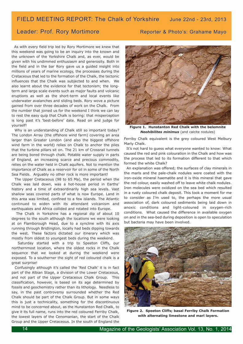
Saturday started with a trip to Speeton Cliffs, ournorthernmost location, where the oldest rocks in the Chalksequence that we looked at during the weekend wereexposed. To a southerner the sight of red coloured chalk is agreat surprise!
Confusingly although it’s called the ‘Red Chalk’ it is in factpart of the Albian Stage, a division of the Lower Cretaceous,and not part of the Upper Cretaceous Chalk Group. Thisclassification, however, is based on its age determined byfossils and geochemistry rather than its lithology. Needless tosay, in the past controversy surrounded whether the RedChalk should be part of the Chalk Group. But in some waysthis is just a technicality, something for the discontinuousmind to be concerned about, as the Hunstanton Red Chalk, togive it its full name, runs into the red coloured Ferriby Chalk,the lowest layers of the Cenomanian, the start of the ChalkGroup and the Upper Cretaceous. In the south of England the
Ferriby Chalk equivalent is the grey coloured West MelburyMarly Chalk. It’s not hard to guess what everyone wanted to know: What
caused the red and pink colouration in the Chalk and how wasthe process that led to its formation different to that whichformed the white Chalk?
An explanation was offered; the surfaces of clay minerals inthe marls and the pale-chalk nodules were coated with theiron-oxide mineral haematite and it is this mineral that gavethe red colour, easily washed off to leave white chalk nodules.Iron molecules were oxidized on the sea bed which resultedin a rusty coloured chalk deposit. This took a moment for meto consider as I’m used to, the perhaps the more usualassociation of, dark coloured sediments being laid down inanoxic conditions and light-coloured in oxygen-richconditions. What caused the difference in available oxygenon and in the sea-bed during deposition is open to speculationbut bacteria may have been involved.
FIELD MEETING REPORT: The Chalk of YorkshireFIELD MEETING REPORT: The Chalk of Yorkshire June 22nd - 23rd, 2013June 22nd - 23rd, 2013
Leader: Prof. Rory MortimoreLeader: Prof. Rory Mortimore Reporter & Photo’s: Grahame MayoReporter & Photo’s: Grahame Mayo
(and calcite nodules)
Magazine of the Geologists’ Association Vol. 13, No. 1, 201414
The other prominent feature that begs a question was thecurious nodularity in the lower part of the Ferriby ChalkFormation (Figure 2). Looking closer it could be seen that thenodules were composed of calcite (chalk) enclosed in a redmarl matrix. Fossils were found in and encrusting thenodules so they were a part of the original sediment. Somedissolution and/or precipitation of calcite might have takenplace. Fossils including inoceramid bivalves were relativelycommon in the marly layers. These observations indicate anearly formation of the nodular texture.
An interesting discovery was made on the beach as wemade our way back for lunch; a weathered tiny Paramoudraflint was found lying amongst the pebbles (Figure 3). Themillimetre thin trace fossil in the centre (Bathichnusparamoudrae) was clearly visible (Figure 3). The surroundingParamoudra flint is usually metres in diameter (and the wordgiant is often used in conjunction with Paramoudra) this is afascinating curiosity. The flint has probably been reduced insize by marine erosion.
On Saturday afternoon we headed a few kilometres southtowards the tip of Flamborough Head, a tongue of landsticking defiantly into the North Sea. This is another featurewe don’t see in our southern Chalk; clearly the Chalk in thenorth is made of sterner stuff. Our first visit in this area wasto Flamborough North Landing, a bay cut into FlamboroughHead. We had now moved up the succession to the Burnham Chalk
Formation (the southern equivalent being Lewes Nodular andSeaford Chalk formations) laid down about 85 million yearsago.
Why are the Yorkshire Chalks harder, more dense and oflower porosity than their equivalent age counterparts in EastAnglia and Southern England? Gravity anomalies in theregion have led to speculation that there may have beengranite emplacements deep under the Yorkshire Wolds, aswell as under what is now the North Sea and the Wash. Heatand hot fluids from these bodies, over a period of hundredsto thousands of years, may have produced low grademetamorphsism turning the once soft porous chalk, similar tothe rock we find in the south, into the more compact andcemented rock of Yorkshire.
It’s not just the northern chalk that is different to thesouthern counterpart; Yorkshire flints are very different aswell being grey and blotchy and frequently have chalk
nodules in them. It’s tempting to say that southern flints areof a superior quality being, largely, a uniform black colour.My guess is that Stone Age man would have probably agreed.The processes that were happening, whilst the chalk wasbeing laid down, could change significantly over time andlocality. For example we saw laminations in one layer of thechalk that Rory interpreted as having been caused by the re-working of the chalk whilst it had been on the sea-bed. But,as he frequently reminded us, due of the limited number ofexposures of the chalk there is need to be cautious in makinginterpretations as to how significant such a feature is. Thereis often uncertainty as to whether such features areextensive, caused by a large scale phenomena or event, orwhether they are just a local feature confined to one area ofthe sea-bed that happens to be exposed and examined.
However, there are features in the Chalk that have beenshown to correlate over great distances of NW Europe andalso mark the end of an old and beginning of a new biologicalchapter. Species below and above a layer are different (abiostratigraphical boundary). The Ulceby Marl (the equivalentof the Lewes Marl in the south) is one such feature. Throughgeochemical analysis this has been identified as volcanic inorigin, it is in fact one of the key marker volcanogenic marlsof the Upper Turonian (about 90 Ma) of Europe. The marl
formed as a result of the weathering of the ash cloud thatblanketed a vast area of the Boreal Sea covering NW Europe.In the field the marl has a buttery feel and green hue,contrasting it with non-volcanogenic marl seams which aremore brittle and lighter coloured. Detailed analysis usingisotope ratios determined more than it was just volcanic ash;the ash was rhyolitic and as such associated with eruptionsfrom off-ocean-ridge volcanoes. But which ocean ridgevolcanoes are unknown. Certainly there were volcanoes ofthis type associated with the North Atlantic to the West.
The south side of the bay at Flamborough North Landingprovided a graphic illustration of how caves originate at marlseams (Figure 4). All of the caves in the image originatefrom the same marl seam. Caves enlarge to become isolatedstacks, a feature of Yorkshire coastal chalk. The pairs offractures making up conjugate fractures form at right angleto each other, a different angle to the conjugate fractures inthe south.
The more energetic of us opted for a cliff-top walk fromFlamborough North Landing to Great Thornwick Bay where
Magazine of the Geologists’ Association Vol. 13, No. 1, 2014 15
we saw the Triple Tabular Flints which form the base of theBurnham Formation. As with the marl seams, on which cavesand ultimately stacks form, these flint bands have had aprofound effect on the landscape. Over vast amounts of timethese highly resistant layers form scarps in the YorkshireWolds; a landscape feature that is crucial in mapping thegeology of the region. It’s fascinating to think that conditions
and events in the sea in which this chalk was laid down about90 million years ago had a significant effect on the landscapewe know today. Without these flint bands the Wolds wouldlook profoundly different.As an aside the name, the Chalk hills of Yorkshire are called,
the Wolds. This name has the same origin, forest, as Weald.Curiously though, in Sussex, the Weald is the name given tothe lowland which lies between the Chalk hills of the Northand South Downs.
At Flamborough North Landing and Thornwick Bay nodularflints give way to tabular flints which give way to carious flints(carious means holey, as in dental caries). What controlsthese stratigraphic changes? Rory informed us are that thesechanges in flint types are present over vast areas of Europe.Is it due to the depth of deposition or due to events orconditions after deposition? Unlocking these unknowns maygive us deeper insights into the changes in climatic and
tectonic conditions during the Upper Cretaceous. Anotherreminder that all is not known about the Chalk and thatfuture insight may yet significantly change our understandingof this period.
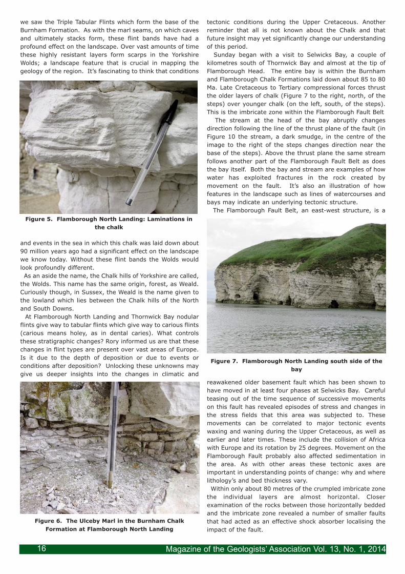
Sunday began with a visit to Selwicks Bay, a couple ofkilometres south of Thornwick Bay and almost at the tip ofFlamborough Head. The entire bay is within the Burnhamand Flamborough Chalk Formations laid down about 85 to 80Ma. Late Cretaceous to Tertiary compressional forces thrustthe older layers of chalk (Figure 7 to the right, north, of thesteps) over younger chalk (on the left, south, of the steps).This is the imbricate zone within the Flamborough Fault Belt
The stream at the head of the bay abruptly changesdirection following the line of the thrust plane of the fault (inFigure 10 the stream, a dark smudge, in the centre of theimage to the right of the steps changes direction near thebase of the steps). Above the thrust plane the same streamfollows another part of the Flamborough Fault Belt as doesthe bay itself. Both the bay and stream are examples of howwater has exploited fractures in the rock created bymovement on the fault. It’s also an illustration of howfeatures in the landscape such as lines of watercourses andbays may indicate an underlying tectonic structure.
The Flamborough Fault Belt, an east-west structure, is a
reawakened older basement fault which has been shown tohave moved in at least four phases at Selwicks Bay. Carefulteasing out of the time sequence of successive movementson this fault has revealed episodes of stress and changes inthe stress fields that this area was subjected to. Thesemovements can be correlated to major tectonic eventswaxing and waning during the Upper Cretaceous, as well asearlier and later times. These include the collision of Africawith Europe and its rotation by 25 degrees. Movement on theFlamborough Fault probably also affected sedimentation inthe area. As with other areas these tectonic axes areimportant in understanding points of change: why and wherelithology’s and bed thickness vary.Within only about 80 metres of the crumpled imbricate zone
the individual layers are almost horizontal. Closerexamination of the rocks between those horizontally beddedand the imbricate zone revealed a number of smaller faultsthat had acted as an effective shock absorber localising theimpact of the fault.
Magazine of the Geologists’ Association Vol. 13, No. 1, 201416
Within the imbricate zone, to the south of the old steps atSelwicks Bay, Rory pointed out cavities (vughs) in the chalkwhich were lined with calcite crystals (Figure 8). He explainedthat the crystals didn’t form in a single event but grew instages. With each tectonic pulse a new layer of crystal waslaid down. By carefully sampling and analysis of the isotopeswithin each of these Russian doll-like layers of a crystal, asequence of when the tectonic pulses occurred could be builtup. Chemical analysis of bulk samples on the other hand, ashas been carried out in the past, have missed the presenceof these distinct episodes of mineralization. Each crystalgrowth corresponding to a pulse of fluids separated in time.It is only with this painstakingly detailed analysis that thetrue picture of events and the meaning of those eventsemerge. Another feature of great interest and speculation,and relatively common in Yorkshire Chalk, are stylolites;narrow bands in the chalk, like the dark pen-drawn traces ofan unwound seismograph chart trace or as one member ofthe group observed like the suture-lines of an ammonite.Stylolites seem to be related to deformation phases that thechalk was subjected too. But where do Stylolites fit into thesequence of post-depositional processes? Has one layer ofchalk differentially moved against another? Or as some,though definitely not Rory, have argued; stylolites may be theresidue, of a massive loss (> 50%), through dissolution, ofoverlying layers of chalk. For now stylolites remain curious
traces in the Chalk that will undoubtedly in the future revealanother fascinating insight into the processes that the Chalkhas undergone when someone demonstrates their cause.Having seen the abundant evidence of the tectonic influencesthat the Chalk at Selwicks Bay had been subjected to,sometime after it was consolidated, Rory pointed out marksin the rock which record an event that happened when thechalk sediment was still unconsolidated; synsedimentaryslumping. A record of a submarine earthquake? Or perhapswhere sediment, settling on a gentle gradient, becameunstable and periodically avalanched down the slope. Furtherevidence of penecontemporaneous (at, or around, the timethe sediment was deposited) movement were seen with pinchand swell structures: the swells in the image have beeneroded). These were formed when entire beds slipped alonga marl seam. These structures differ to the previouslymentioned slumping, where it was the contents of the bed
which moved, rather than here where it was the entire bedthat moved. Appreciation of the location of marl seams, andthe Chalk formations which contain conjugate fractures inthem (Flamborough Chalk), is vital to an understanding ofthe hydrogeology of the area. Where the conjugate fracturesintersect on a marl seam, the weaken intersection pointsubsequently erodes to form a pipe (Figure 9) which can bean important subterranean water channel. Conjugatefractures also control the formation of caves and stacks thatYorkshire Chalk is renowned for. It is interesting to note thatthe equivalent of the Flambourough Chalk in the south is theNewhaven Chalk, which also forms caves but these don’tdevelop into stacks due to One of the fractures of theFlamborough Fault Belt runs out to sea through the centre ofSelwicks Bay. The zone of this fracture is strikinglyhighlighted, as a band of fractured chalk embedded in acrystalline calcite matrix, where it has been polished by theaction of sea. The calcite crystals were formed as a result ofthe fracture allowing calcium carbonate-saturated water topercolate up through the strata, precipitating calcite crystalsin veins and cementing the chalk fragments to form a breccia.Selwicks Bay had proved to be a veritable treasure-trove ofinteresting features. A couple of us, though, couldn’t resistthe temptation of one last addition to this; finding someactual treasure. Trapped by pools in the chalk were smallpebbles of the semi-precious stone jet, fossilised wood froma Jurassic relative of the Monkey Puzzle tree, that hadprobably been wrenched by storms from off-shore seams 40km to the north, just south of Whitby, and because of theirlightness washed ashore.
Magazine of the Geologists’ Association Vol. 13, No. 1, 2014 17
If you need a more stark illustration as to there being aNorth South divide, on Chalk hardness that is, look no furtherthan the Old Lighthouse at Flamborough Head. This, slender,four story structure is built from chalk! Not just theoccasional block of exceptionally hard chalk used within abuilding or as an infillbehind a more resistantstone façade, as we’reused to seeing in thesouth, but this wasstructurally sound rockused to build a tallstructure on anextremely exposedheadland. Why are thechalks of the Northernand Southern Provincesso different? Althoughbroadly laid down in thesame Boreal Sea theconditions ofsedimentation wereprobably very differenton the sea-bed. We sawthe Red Chalk andnodularity in the FerribyChalk – very different tothe Grey Chalk of BeachyHead, and flints of aspecial type wereabundant in the WeltonChalk Formation, thenorthern equivalent ofthe flintless New PitChalk Formation North ofthe Wash the Chalksformed in a ‘North SeaBasin and developedtheir own uniquelithologies. In additionthe Northern Chalk isharder, possibly becauseof different underlyingthermal gradients relatedto granites.
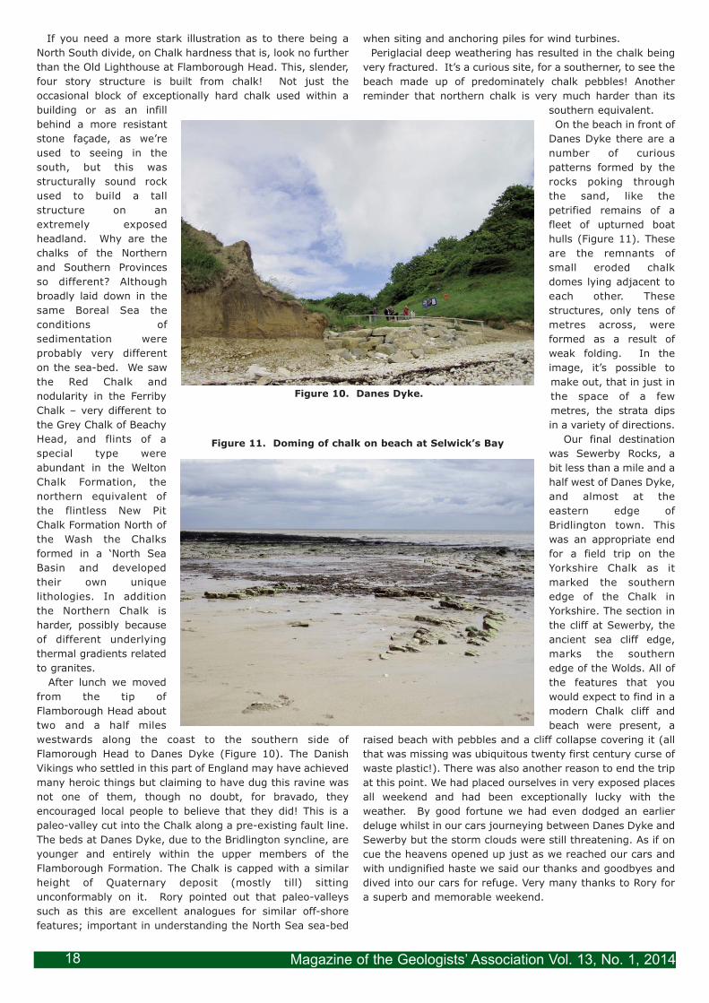
After lunch we movedfrom the tip ofFlamborough Head abouttwo and a half mileswestwards along the coast to the southern side ofFlamorough Head to Danes Dyke (Figure 10). The DanishVikings who settled in this part of England may have achievedmany heroic things but claiming to have dug this ravine wasnot one of them, though no doubt, for bravado, theyencouraged local people to believe that they did! This is apaleo-valley cut into the Chalk along a pre-existing fault line.The beds at Danes Dyke, due to the Bridlington syncline, areyounger and entirely within the upper members of theFlamborough Formation. The Chalk is capped with a similarheight of Quaternary deposit (mostly till) sittingunconformably on it. Rory pointed out that paleo-valleyssuch as this are excellent analogues for similar off-shorefeatures; important in understanding the North Sea sea-bed
when siting and anchoring piles for wind turbines. Periglacial deep weathering has resulted in the chalk being
very fractured. It’s a curious site, for a southerner, to see thebeach made up of predominately chalk pebbles! Anotherreminder that northern chalk is very much harder than its
southern equivalent.On the beach in front of
Danes Dyke there are anumber of curiouspatterns formed by therocks poking throughthe sand, like thepetrified remains of afleet of upturned boathulls (Figure 11). Theseare the remnants ofsmall eroded chalkdomes lying adjacent toeach other. Thesestructures, only tens ofmetres across, wereformed as a result ofweak folding. In theimage, it’s possible tomake out, that in just inthe space of a fewmetres, the strata dipsin a variety of directions.
Our final destinationwas Sewerby Rocks, abit less than a mile and ahalf west of Danes Dyke,and almost at theeastern edge ofBridlington town. Thiswas an appropriate endfor a field trip on theYorkshire Chalk as itmarked the southernedge of the Chalk inYorkshire. The section inthe cliff at Sewerby, theancient sea cliff edge,marks the southernedge of the Wolds. All ofthe features that youwould expect to find in amodern Chalk cliff andbeach were present, a
raised beach with pebbles and a cliff collapse covering it (allthat was missing was ubiquitous twenty first century curse ofwaste plastic!). There was also another reason to end the tripat this point. We had placed ourselves in very exposed placesall weekend and had been exceptionally lucky with theweather. By good fortune we had even dodged an earlierdeluge whilst in our cars journeying between Danes Dyke andSewerby but the storm clouds were still threatening. As if oncue the heavens opened up just as we reached our cars andwith undignified haste we said our thanks and goodbyes anddived into our cars for refuge. Very many thanks to Rory fora superb and memorable weekend.
Magazine of the Geologists’ Association Vol. 13, No. 1, 201418
Magazine of the Geologists’ Association Vol. 13 No. 1, 2014
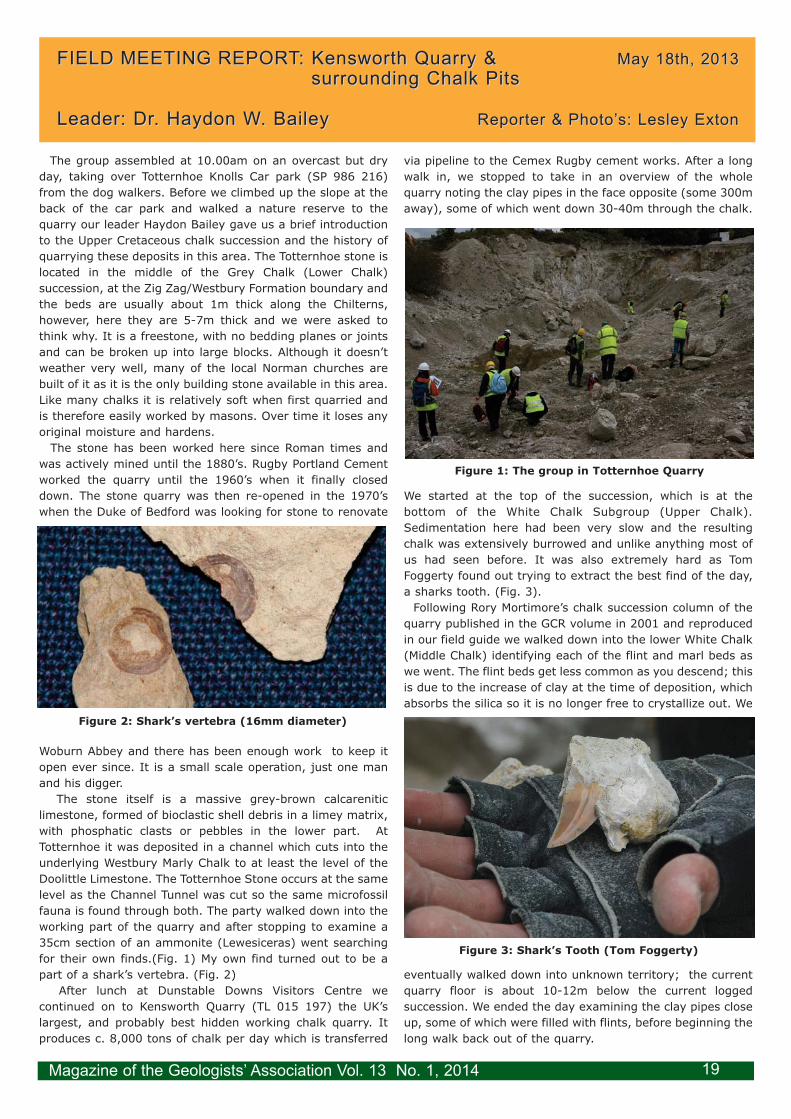
The group assembled at 10.00am on an overcast but dryday, taking over Totternhoe Knolls Car park (SP 986 216)from the dog walkers. Before we climbed up the slope at theback of the car park and walked a nature reserve to thequarry our leader Haydon Bailey gave us a brief introductionto the Upper Cretaceous chalk succession and the history ofquarrying these deposits in this area. The Totternhoe stone islocated in the middle of the Grey Chalk (Lower Chalk)succession, at the Zig Zag/Westbury Formation boundary andthe beds are usually about 1m thick along the Chilterns,however, here they are 5-7m thick and we were asked tothink why. It is a freestone, with no bedding planes or jointsand can be broken up into large blocks. Although it doesn’tweather very well, many of the local Norman churches arebuilt of it as it is the only building stone available in this area.Like many chalks it is relatively soft when first quarried andis therefore easily worked by masons. Over time it loses anyoriginal moisture and hardens.
The stone has been worked here since Roman times andwas actively mined until the 1880’s. Rugby Portland Cementworked the quarry until the 1960’s when it finally closeddown. The stone quarry was then re-opened in the 1970’swhen the Duke of Bedford was looking for stone to renovate
Woburn Abbey and there has been enough work to keep itopen ever since. It is a small scale operation, just one manand his digger.
The stone itself is a massive grey-brown calcareniticlimestone, formed of bioclastic shell debris in a limey matrix,with phosphatic clasts or pebbles in the lower part. AtTotternhoe it was deposited in a channel which cuts into theunderlying Westbury Marly Chalk to at least the level of theDoolittle Limestone. The Totternhoe Stone occurs at the samelevel as the Channel Tunnel was cut so the same microfossilfauna is found through both. The party walked down into theworking part of the quarry and after stopping to examine a35cm section of an ammonite (Lewesiceras) went searchingfor their own finds.(Fig. 1) My own find turned out to be apart of a shark’s vertebra. (Fig. 2)
After lunch at Dunstable Downs Visitors Centre wecontinued on to Kensworth Quarry (TL 015 197) the UK’slargest, and probably best hidden working chalk quarry. Itproduces c. 8,000 tons of chalk per day which is transferred
via pipeline to the Cemex Rugby cement works. After a longwalk in, we stopped to take in an overview of the wholequarry noting the clay pipes in the face opposite (some 300maway), some of which went down 30-40m through the chalk.
We started at the top of the succession, which is at thebottom of the White Chalk Subgroup (Upper Chalk).Sedimentation here had been very slow and the resultingchalk was extensively burrowed and unlike anything most ofus had seen before. It was also extremely hard as TomFoggerty found out trying to extract the best find of the day,a sharks tooth. (Fig. 3).
Following Rory Mortimore’s chalk succession column of thequarry published in the GCR volume in 2001 and reproducedin our field guide we walked down into the lower White Chalk(Middle Chalk) identifying each of the flint and marl beds aswe went. The flint beds get less common as you descend; thisis due to the increase of clay at the time of deposition, whichabsorbs the silica so it is no longer free to crystallize out. We
eventually walked down into unknown territory; the currentquarry floor is about 10-12m below the current loggedsuccession. We ended the day examining the clay pipes closeup, some of which were filled with flints, before beginning thelong walk back out of the quarry.
FIELD MEETING REPORT: FIELD MEETING REPORT: Kensworth Quarry & Kensworth Quarry & May 18th, 2013May 18th, 2013surrounding Chalk Pitssurrounding Chalk Pits
Leader: Dr. Haydon W. BaileyLeader: Dr. Haydon W. Bailey Reporter & Photo’s: Lesley ExtonReporter & Photo’s: Lesley Exton
19
Magazine of the Geologists’ Association Vol. 13, No. 1, 2014
PLEASE NOTE THE FOLLOWING INFORMATION FOR FIELD MEETINGS
ENQUIRIES & BOOKINGS: Geoff Swann organises day and weekendmeetings in the UK. Michael Ridd is responsible for overseas and longerexcursions. Sarah Stafford at the GA office is responsible for bookings,payments and general administration ‐ [email protected]
You must book through the GA office to confirm attendance. Please donot contact the field meeting leader directly. Meeting times and locationswill be confirmed on booking. These are not normally advertised inadvance, as there have been problems with members turning up withoutbooking or paying and maximum numbers being exceeded. Fieldmeetings are open to non‐members although attendance by non‐members is subject to a £5 surcharge on top of the normaladministration fee. Some meetings may have restrictions on age(especially for under 16’s) or be physically demanding. If you areuncertain, please ask.
PAYMENTS for day and weekend meetings must be made beforeattending any field meeting via telephone (credit card) or post. Chequesshould be made out to Geologists’ Association. Please give an email andcontact number and please also provide an emergency contact nameand telephone number at the time of booking.
There are separate arrangements for overseas meetings.
TRANSPORT is normally via private car unless otherwise advertised. If youare a rail traveller, it may be possible for the GA office to arrange foranother member to provide a lift or collect you from the nearest railwaystation. This service cannot be guaranteed, but please ask before booking.Please indicate on your booking form if you are able to offer a lift.
PUBLIC LIABILITY INSURANCE for field meetings is provided but personalaccident cover remains the responsibility of the participant. Furtherdetails are available on request from the GA office.
SAFETY IS TAKEN VERY SERIOUSLY. SHOULD YOU BE UNSURE ABOUTEITHER THE RISKS INVOLVED OR YOUR ABILITY TO PARTICIPATE SAFELY,YOU MUST SEEK ADVICE FROM THE GA OFFICE BEFORE BOOKING. PLEASEMAKE SURE THAT YOU STUDY ANY RISK ASSESSMENT OR SAFETYBRIEFING AND THAT YOU HAVE ALL THE SAFETY EQUIPMENT SPECIFIED.YOU MUST DECLARE, AT THE TIME OF BOOKING, ANY DISABILITIES ORMEDICAL CONDITIONS THAT MAY AFFECT YOUR ABILITY TO SAFELYATTEND A FIELD MEETING. YOU MAY BE ASKED TO PROVIDE FURTHERINFORMATION ON ANY PRESCRIPTION DRUGS ETC THAT YOU MAY USEWHILST ATTENDING A FIELD MEETING. IN ORDER TO ENSURE THESAFETY OF ALL PARTICIPANTS, THE GA RESERVES THE RIGHT TO LIMITOR REFUSE ATTENDANCE AT FIELD MEETINGS.
EMERGENCY CONTACT: if you are lost or late for the start of a meeting,an emergency contact is available during U.K. field meetings by calling theGA mobile phone 07724 133290. The mobile phone will only be switchedon just before and during field meetings. For routine enquiries please callthe GA office on the usual number.
TRAVEL REGULATIONS are observed. The GA acts as a retail agent forATOL holders in respect of air flights included in field meetings. All flightsare ATOL protected by the Civil Aviation Authority (see GA Circular No.942, October 2000 for further details). Field meetings of more than 24hours duration or including accommodation are subject to the PackageTravel Regulations 1992. The information provided does not constitute abrochure under these Regulations.
CIRCULAR No. 998 March, 2014
FIELD MEETINGS IN 2014We are hoping to arrange additional fossil collectingopportunities during the year. There may not betime to advertise these in the Circular so if youwould like details when they become availablecontact Sarah Stafford at the GA office.FOR FINALISED DATES AND FOR ANY CHANGES TOTHE PROGRAMME PLEASE REFER TO OUR WEBSITE www.geologistsassociation.org.uk THE INFERIOR OOLITE OF DORSETLeader: Bob ChandlerSaturday 1st – Sunday 2nd MarchDetails have still to be finalised but Bob will betaking us to several temporary exposures of therichly fossiliferous inferior oolite. we may also visitsome coastal outcrops depending on the state ofthe beach and cliffs.Equipment: you must have a hard hat, appropriateclothing and footwear.Cost & booking: numbers will be strictly limited to20. Further details will be available from SarahStafford at the GA Office. register with Sarahsending an administration fee of £15 per person toconfirm your place.QUARRIES IN THE SOMERTON AREA, SOMERSETLeader: Simon CarpenterFriday 28th March A day exploring the Upper Triassic and LowerJurassic rocks of the Somerton and Langport area,Somerset. Please note the date – the meeting hasbeen scheduled for Friday to resolve the accessproblems that led to its postponement last year. A
number of working quarries in the Somerton andLangport areas of Somerset will be visited whererocks of predominantly Upper Triassic age areexposed. At Ashen Cross quarry these rocks arecarefully extracted, cut and polished for ornamentalpurposes. The limestone contains a restrictedinvertebrate assemblage as well as occasionalisolated marine reptile bones. There are also manyinteresting sedimentary features. Attendees shouldbe capable of dealing with the conditions inworking quarries.Equipment: Hard hat and hi‐vis jacket. Appropriateclothing and footwear. Pub lunch or sandwiches. Cost & booking: Numbers will be limited to 25.Further details will be available from Sarah Staffordat the GA office. Register with Sarah sending anadministration fee of £5 per person to confirm yourplace.THE CHALK OF THE HERTFORDSHIRE ANDCAMBRIDGESHIRE BORDERLeader: Haydon BaileySaturday 12th April The purpose of this meeting is to provide anoverview of the Chalk in the Steeple Morden andAshwell village area on the Hertfordshire/Cambridgeshire border. We will visit two quarries atSteeple Morden, Ashwell Springs (River Rhee/Camrising from Totternhoe Stone source), AshwellChurch (Totternoe Stone building & fascinatinggraffiti) and a brief stop to admire Plenus marlsection in a private garden. Packed or pub lunch (tobe arranged).
The start point will be the car park at Ashwell andMorden station – it may be possible to meetattendees travelling by train. The total walkingdistance is 2 ‐ 3 km. No major slopes or otherproblems. Attendees should be capable of dealingwith conditions in working quarries. Equipment: You must have a hard hat, high visjacket and safety glasses.Cost & booking: Numbers will be strictly limited to20. Further details will be available from SarahStafford at the GA office. Register with Sarahsending an administration fee of £5 per person toconfirm your place.
GEOLOGICAL GEMS OF THE SOUTH DOWNSLeader: Rory MortimoreSaturday 14th – Sunday 15th June This weekend meeting celebrates Rory’s two yearsas GA president and also the publication of hisrevised GA Chalk Guide. The programme has still tobe finalised but at present on the Saturday we willstart at Beachy Head and end in the Cuckmerevalley. Sunday will be a walk on the Downsprobably around Firle and Glynde. The itinerary ispartly determined by comments Rory has had backfrom GA members who find walking too far difficultbut would still love to get into the field. So theitineraries will be designed with everyone in mind –stopping points for overviews as well as shorter andflat walks. The most strenuous will be Beachy Headwhich, from experience, most people seem tomanage. We will be based in the Lewes area. If
20
Magazine of the Geologists’ Association Vol. 13, No.1 2014
there is sufficient interest we will arrange a groupmeal for the Saturday evening.Equipment: You must have a hard hat, appropriateclothing and footwear. Cost & booking: Numbers will be limited to 25.Further details will be available from Sarah Staffordat the GA office. Register with Sarah sending anadministration fee of £10 per person to confirmyour place.
DEVON GEOLOGY WEEKENDLeader: Richard ScrivenerSaturday 28th – Sunday 29th June On Saturday we will look at the Permian red bedsand the lamprophyric and alkali‐basalt lavas (ExeterVolcanics) of the Crediton Trough. Details have stillto be decided but localities may include WestSandford (Bow Breccia and Knowle Sandstone –early Permian), Knowle Hill Quarry (lamprophyriclava – early Permian), Posbury or Uton quarries(alkali basalt ‐ early Permian), Cromwell’s Cutting,Crediton (Newton St. Cyres Breccia – mid‐ to latePermian) and Newton St Cyres Golf Course(Crediton Breccia – late Permian). In addition to thesedimentary and volcanic features, there will be ademonstration of the unroofing history of theDartmoor Granite. On Sunday we will look at theDartmoor Granite and its mineralisationcommencing at Haytor. We will look at sections onthe tor and in nearby quarries in coarse‐grainedmegacrystic and non‐megacrystic biotite granites.We will then travel on to the Birch Tor and VitiferTin mines of central Dartmoor to examine the openworkings and assemblages of quartz‐tourmaline‐cassiterite‐haematite. In the afternoon we willmove to either the Hemerdon Tugsten Mine(depending on operational constraints) or anotherquarry. Equipment: You must have a hard hat and hi‐visjacket and suitable clothing and footwear. Packedor pub lunch both days.Cost & booking: Numbers will be strictly limited to20. Further details will be available from SarahStafford at the GA office. Register with Sarahsending an administration fee of £15 per person toconfirm your place.
WEALDEN EXCURSION ‐ joint meeting with theHastings & District Geological SocietyLeaders: Ken Brooks, Peter Austen and EdJarzembowskiSaturday 20th July Following last year’s field visit to Cliff End, east ofHastings, we will be visiting another section of thisclassic five mile lower Wealden coastline. The exactdetails of the field trip will not be known untilnearer the time as it will depend on accessconditions at a number of points along the coast.We will be walking along the beach over shingleand some rocks which may be slippery. Care shouldalso be taken to keep away from the base of thecliffs in case of rock‐falls, particularly after wetweather. Total return distance 5–6 km. Equipment: You must bring a hard hat and suitablefootwear. Packed lunch. Cost & booking: Further details will be availablefrom Sarah Stafford at the GA office. Register withSarah sending an administration fee of £5 perperson to confirm your place.
**NEW MEETING ADDED**
GREAT TEW QUARRY, SW of Banbury Leader: Andy Swift Saturday 2nd August Equipment: You must bring a hard hat and suitablefootwear. Packed lunch. Cost & booking: Further details will be availablefrom Sarah Stafford at the GA office. Register withSarah sending an administration fee of £5 perperson to confirm your place.
THE GEOLOGY OF THE ISLE OF MANLeaders: Dave Quirk and Dave BurnettFriday 19th ‐ Monday 22nd September This meeting celebrates the new GA guide to theIsle of Man written by the leaders. Both have beenclosely involved with hydrocarbon exploration inthe surrounding areas. The programme will includeexcursions to view to part of the Iapetus Suture,diverse Lower Palaeozoic turbidites, Caledonianfolds and granite, Devonian continental sediments,a Surtseyan volcanic centre and Carboniferous reefsplus Viking carved stones, medieval castles andindustrial archaeological sites. Attendees will needto make their own arrangements for travel to andfrom the island – either by ferry or air. Travel onthe island will be by minibus. We hope to blockbook rooms in a suitable hotel so that we can easilymeet everyone and pick up/drop off is easier. Thosewho wish to arrange their own accommodation willneed to be able to get to the hotel in order to getthe minibus. Moderately strenuous walks, someclambering and possibly wet and windy weather onexposed coastal exposures should be expected –attendees should ensure that they can cope withthese conditions and have suitable clothing andfootwear.Equipment: Hard hats are essential. Cost & booking: The attendance fee will be setonce we have details of minibus costs etc. Furtherdetails will be available from Sarah Stafford at theGA office. Please register your interest with Sarahas soon as possible so that we can gauge numbers.
DORSET COAST WEEKENDLeader John C.W. Cope Saturday 27th – Sunday 28th September (date tobe confirmed)Following the success of the previous two meetingsto the west Dorset coast we will be based inWeymouth and will be looking mainly at the UpperJurassic. We will finish at about 16:00 on Sunday.There may well be some steep ascents /descents ‐dependent on the weather.Equipment: Participants should be equipped forvery rough beaches and should have stout footwearwith ankle support. Helmets are essential but HIvis. jackets will not be required. Cost & booking: Numbers will be limited to 25.Register with Sarah Stafford at the GA officesending an administration fee of £15 to confirmyour place.
Two meetings have been carried over from 2013having had to be postponed due to accessproblems:
BUCKS GEOLOGYLeader: Jill EyersDate to be confirmedWe will visit several quarries, one of which hasbeen restored in part by a grant from the Curry
Fund. Packed or pub lunch, car sharing may benecessary. Attendees should be capable of dealingwith the conditions in working quarries.Equipment: Hard hat and hi‐vis jacket. Appropriateclothing and footwear. Cost & booking: Numbers will be limited to 20.Further details will be available from Sarah Staffordat the GA office. Register with Sarah sending anadministration fee of £5 per person to confirm yourplace.
BARTON CLIFFS ‐ FOSSILS AND GEOENGINEERINGLeader: Peter ReadingDate to be confirmedThe cliffs at Barton on Sea provide an excellentopportunity to view the Barton Beds close up. Thesection between Avon Beach and Hordle isparticularly good and includes one of the South’smost impressive coastal landslides. On a good daythere are also panoramic views across to the Isle ofWight and The Needles to the east and Swanage tothe west. The cliff top is an ideal position to viewwhat was once the Solent River valley. The largelandslip at Barton Cliff provides an excellentlocation for fossil collecting with fresh materialbeing exposed on a regular basis. The beds includeimportant horizon markers. The section at Highcliffis also a good location to see modern coastaldefence management. Access to some parts of theBarton landslip may be restricted at high tide alsoduring and after wet weather the landslip can behazardous. However there are plenty of goodlocations which are safe and will provide goodviewing and fossil collection points.Equipment: Please bring a hard hat, appropriateclothing and footwear. The cliffs can be verymuddy and uneven in places. Bring a packed lunch.Cost & booking: Further details will be availablefrom Sarah Stafford at the GA office. Register withSarah sending an administration fee of £5 perperson to confirm your place.
IN THE PIPELINE (Dates and details to bearranged)...
THE BUILDING STONES OF TOTTENHAM COURTROADLeader: Ruth Siddall
THE BUILDING STONES OF ST ALBANS Leader: Diana Smith
OVERSEAS FIELD MEETINGS 2014
GREEK ISLAND VOLCANOES13th ‐ 26th September ‐ POSTPONED UNTIL 2015Leader: Dr Paul OlverOur trip takes us to the Aegean volcanic arc wherethe islands of Santorini (Thera) and Nisyros areactive centres located where major faults cross thisplate collision zone. Here, the African plate movingnorth‐east is subducted beneath the westerly‐moving Anatolian microplate along the HellenicTrench causing frequent earthquakes and localisedvolcanism. Initially, we will be visiting Heraklion, thecapital of Crete, whose Bronze Age Minoancivilisation was spectacularly revealed by the workof British archaeologist, Sir Arthur Evans. A guidedtour will introduce the royal palace (or maybenecropolis) at Knossos of the legendary King Minoswhose royal line was ended by the cataclysmic
21
Magazine of the Geologists’ Association Vol. 13, No. 1, 2014
volcanic eruption of 1650 BC at Santorini, 110 km tothe north. Crete is dominated by the precipitousWhite Mountains of Triassic and early Jurassicdolomitic limestones which run east‐west along theisland’s length. Karstic features such as the AlmirosSpring and deep dolines will be visited during ourfirst few days around Mount Psiloritis (2456 m), thehighest in the island. We then make our way, viathe island of Kos, to Nisyros where we spend a daywithin its 24,000 year old caldera. This andesiticcaldera is largely occupied by a series of dacitic andrhyolitic domes which at their western end shownumerous active fumaroles, the site of majorphreatic eruptions between 1873 and 1887.Travelling again via Kos, we then move ontoSantorini (Thera), Southern Europe’s only majorvolcano outside Italy which last erupted in 1950.Two large caldera‐forming eruptions within the last100,000 years preceded the famous Plinianeruption of 1650 BC which buried the local Minoancity of Akrotiri and whose tsunami, generated bysubmarine pyroclastic flows, caused havoc on theisland of Crete and its sophisticated Minoancivilisation. We will take a boat excursion to NeaKameni, an andesitic volcano, which has grown upin the caldera since the Bronze Age cataclysm.There will also be time for a visit to theArchaeological Museum, Fira Quarry with itsexposures of the Minoan pumice, and a walk downinto the caldera to view the metamorphic basementbeneath the active volcano. Returning to Crete andits fossiliferous limestone crags, we will visit thelarge Dicti Cave, said to be the birthplace of Zeus inGreek mythology, and look for fossil corals andbivalves at a famous location near Markrilia. Thebest preserved Minoan city is Kato Zakros, firstexcavated in 1961, is next on our itinerary togetherwith the impressive limestone cliffs within theValley of the Dead. Our final stops will be in EasternCrete with a tour around the once‐impregnableVenetian fortress island of Spinalonga in thepicturesque Gulf of Mirabello. A walk into theImbros Gorge, cutting through the highly deformedlimestones of the Alpine cordillera, will drawtogether the tectonic history of this special island. Cost & booking: Return flights to Heraklion fromGatwick and 13 nights hotel accommodation withsix nights half board and seven nights bed &breakfast are included. All coach and ferry travelduring the tour is also within the overall cost. Thetotal tour price is TBA. A deposit of £TBA will berequired when the trip is re‐scheduled. For furtherdetails please contact Dr Paul Olver by email:[email protected] or by ‘phone 01432761693.LISBON AND THE GEOLOGICAL, NATURAL HISTORYAND SCIENCE MUSEUMSThursday 16th – Monday 20th October Leaders: Dr Maria Cristina Cabral & Dr Ana CristinaAzerêdo (University of Lisbon), Dr Luis Duarte(University of Coimbra) and Prof Miguel Ramalho(Geological Museum).We continue our series of ‘behind the scenes’ toursof international standard geological museums,arranged by Alan Lord and David & Anne Bone. In2014, we will be visiting the Geological Museumand the Natural History and Science Museum (partof the University of Lisbon), also in Lisbon. Museumwebsites can be found at: Geological Museum‐www. lneg.pt /MuseuGeologico/Museum of NaturalHistory and Science (of the University of Lisbon) ‐
http://mnhnc.ul.pt. Travelling to Lisbon onThursday 16th October, we gather in the eveningfor dinner (cost not included) and an introductionto the weekend. The programme includes museumtours and behind the scenes on Friday, a coachexcursion to a variety of important field sites onSaturday (the geology of the Lisbon area is veryvaried!) and free time and optional guided city walkon Sunday, return home on Monday 20th October.Cost & booking: Please make and pay for your owntravel arrangements to Lisbon, once the trip hasbeen confirmed as viable. The estimated cost is£300 per person (twin or double room) and £430(single), excluding flights and transfers. The priceincludes 4 nights hotel bed & breakfast, leaders’expenses, coach hire, entrance fees andadministration. Registration closing date is 6th April2014 with full payment by 1st May 2014. Furtherdetails from David Bone [email protected] (preferred) or by post at 4Kensington Road, Chichester, West Sussex PO197XR; a non‐refundable deposit of £50 per person bycheque payable to the Geologists’ Association tothe above address will be required to confirm yourbooking. These trips are popular and numbers willbe limited so book early.
NEW ZEALANDLeader: Dr Michael RiddSunday 2nd – Sunday 23rd November Preliminary planning is under way for a GA trip toNew Zealand in November 2014. We shall look atthe geology and natural history of both North andSouth Islands, travelling by coach, starting atAuckland and finishing at Christchurch. The leaderwill be Mike Ridd who has lived and worked in NewZealand and who carried out research there for aPhD.Over about an 18 day tour we shall see Maoriculture and look at the hot springs and geysers ofRotorua; travel to Gisborne to see mud diapirs andCenozoic flysch sequences; visit the Morere HotSprings and travel on to Napier and Hastings to seeits art nouveau architecture and collect fossils; thenlook at the amazing gannet colony at CapeKidnappers; travel south through the Pinot NoirMartinborough vinyards to Wellington; cross theCook Strait by ferry to Picton and on to Blenheim;then over to the West Coast of South Island to lookat the Alpine Fault, metamorphic basement rocks,the ‘pancake rocks’ and a couple of glaciers; on toQueenstown; and finally across the spectacularbraided rivers of the Canterbury Plain toChristchurch where we can examine some of theeffects of the February 2011 earthquake as well asthe extinct volcano of Banks Peninsula. Cost & booking: The provisional cost of the trip is£3800 per person, based on B&B accommodation incomfortable hotels (double occupancy ‐ there willbe a single‐occupancy supplement), including ferrycrossing, airport pick‐up and drop‐off, and ageological guidebook. If you are interested intaking part in this trip pleaseemail:[email protected]
GEOLOGISTS' ASSOCIATION LOCAL GROUPS (LG) AND AFFILIATED SOCIETIES
Amateur Geological SocietyContact Julia Daniels 020 8346 1056. Field trips: [email protected]
Bath Geological SocietyMarch 6 The Stonehenge Phosphatic Chalk – ProfRory MortimoreApril 3 The 2010 Eruption of Eyjafjallajokull, Iceland,and the impacts of volcanic ash on aviation – DrJeremy PhillipsMay 1 Foraminiferal facts: from Cretaceouspalaeoclimates to Caribbean tephrochronology – DrJodie FisherJune 5 Space technologies, hazardous terrain anddisaster risk reduction – Dr Richard Teeuwwww.bathgeolsoc.org.uk Belfast Geologists’ SocietyContact [email protected] Black Country Geological SocietyMarch 21 Hampshire Landslides & GeotechnicalModelling – Dr Andy GibsonContact Linda Tonkin: [email protected] www.bcgs.info Brighton & Hove Geological SocietyMarch 5 Chalk, Black Shales, Climate change andSea Level Change: unravelling Late Cretaceoushistory – Prof Ian JarvisMarch 19 AGM and Members EveningApril 2 The Animals that David AttenboroughForgot: the Natural History of Living and FossilBryozoans – Dr Paul TaylorContact John Cooper 01273 292780 Email:john.cooper@brighton‐hove.gov.uk; www.bhgs.org Bristol Naturalists’ Society Contact 01373 474086Email: [email protected] www.bristolnats.org.uk Cambridgeshire Geology Club (LG)Contact Ken Rolfe 01480 496973, mob: 07777678685www.cambridgeshiregeologyclub.org.ukCarn Brea Mining SocietyMarch 18 Cornish Estuarine Sediment: HumanImpact versus Natural Processes – Duncan PirrieApril 15 AGM followed by BBC film The LevantDisasterContact Lincoln James 01326 311420www.carnbreaminingsociety.co.ukCheltenham Mineral and Geological SocietyLectures contact Ann Kent 01452 610375Field trips contact Kath Vickers 01453 827007http://cmgs.yolasite.com Cumberland Geological SocietyMarch 12 AGM and President’s addressMarch 15 Annual Dinner, guest speaker – Prof RoryMortimore President of the Geologists' AssociationFor details on the activities of the CumberlandGeological Societywww.cumberland‐geol‐soc.org.ukCymdeithas Daeaereg Gogledd Cymru: NorthWales Geology Association ( LG)Contact Jonathan Wilkins 01492 583052Email: [email protected] www.ampyx.org.uk/cdgcCymdeithas Y Daearegwyr Grwp De Cymru: SouthWales Group Geologists’ Association (LG)March 22 Presidential talk ‘The World of Geology’ –Geraint OwenContact Lynda Garfield: [email protected] Devonshire Association (Geology Section)Contact Jenny Bennett 01647 24033Email: [email protected]
22
Magazine of the Geologists’ Association Vol. 13, No.1 2014 23
www.devonassoc.org.ukThe Dinosaur SocietyContact Prof Richard Moody: [email protected]. Dorset Group of the Geologists’ Association (LG)Contact Doreen Smith 01300 320811Email: [email protected] Natural History & Archaeological SocietyContact Jenny Cripps:[email protected] Science Teachers AssociationMembership Mike Tuke 014804 [email protected] www.esta‐uk.netEast Herts Geology ClubCheck website for venue or contact Diana Perkins01920 463755Visitors most welcome ‐ £2;[email protected] emailEast Midlands Geological SocietyMarch 15 AGM to be followed QuaternaryGlaciations of the Midlands and East Anglia – JimRoseApril 12 Sinking Cities – Tony Walthamwww.emgs.org.ukEdinburgh Geological SocietyEmail: [email protected]; www.edinburghgeolsoc.orgEssex Rock and Mineral SocietyMarch 11 China, a Geologist's Dream: the Karstaround Yangshuo – Roger LloydApril 6 Field meeting: The Cliff, Althorne, Essex –Jeff SaywardApril 8 Members’ Pot PourriApril 27 Field meeting: Wrabness, Essex – BillGeorge and Graham WardMay 13 Quaternary Glaciations of Britain andespecially Essex – Prof Jim RoseMay 25 Field meeting: The Naze, Walton – GeraldLucyJune 10 A Pictorial History of Essex Geology – BillGeorgeContact Ros Smith 01245 441201 Email:[email protected] Geological Society (LG)March 7 Numbers, models and layered rocks – DrPeter BurgessApril 4 Exploring a Quaternary Volcano in EasternTurkey – Jeremy GoffMay 9 tbaMay 11 Field meeting: Berkshire Geoconservation –Dr Lesley DunlopMay 30 – June 4 Field meeting: North York Coastand Durham Permian with David Walmsley andGraham WilliamsJune 13 Landslides and Subsidence – Dr DavidShilstonField Trip Contact Dr Graham Williams 01483573802; Contact Judith Wilson Email:[email protected] www.farnhamgeosoc.org.uk Friends of the Sedgwick Museum, CambridgeContact Dr Peter Friend 01223 333400www.sedgwickmuseum.org/activities/friends.html Geological Society of GlasgowContact Dr Iain Allison Email:[email protected] www.geologyglasgow.org.uk
Geological Society of NorfolkMarch 20 The Bytham River Story: key evidence forunderstanding pre‐glacial environmental changeand early human occupancy in Britain – ProfessorJim RoseContact Martin Warren Email:[email protected] www.norfolkgeology.co.ukHampshire Gem, Fossil & Mineral SocietyContact Mr Roger Brown Email:[email protected] & Hillingdon Geological Society (LG)March 8 Spring Social.March 12 The Walbrook, the City of London’s River:its Rise and Fall – Stephen MyersMarch 15 Field meeting – visit to Oxford Museumof Natural HistoryApril 9 Arctic Ocean Research – Dr RenskeGelderloos and Dr Camille LoqueApril 11‐14 Field meeting – SomersetMay 14 AGM followed by What are Komatiites ? –John StanleyJune 11 Rock breakdown in extreme environments:from Namibia to Mars – Prof Heather VilesContact Jean Sippy 020 8422 1859; Field tripinformation Allan Wheeler 01344 455451www.hhgs.org.uk Hastings and District Geological SocietyContact Ken Brooks Email: [email protected] http://hastingsgeology.btck.co.uk Hertfordshire Geological Society (LG)March 6 AGM, followed by presentation by CharlieBell (HMWT) Hertfordshire’s chalk streams – riversdown the drain?March 22 Faulds Gypsum Mine, Staffordshire – NoelWorleyApril 10 Percy Evans Lecture – The Petroleum Play:Concept and Application for HydrocarbonExploration – Steve SmithMay 8 From polar bears to deep‐sea seeps: apalaeontologist's view of Greenland – Dr SimonKellyMay 16 ‐ 19 GA/Geological Society: Puddingstoneweekend, book via Geological Society of London.Conference Speakers including Brian Lovell, JennyHuggett; Field trips to Hertfordshire (Leader ChrisGreen) & France (Florence Quesnel) June 12 Dinosaurs and Art: A Historical Perspective– Prof Dick Moody Contact Lesley Exton Email:[email protected] www.hertsgeolsoc.ology.org.uk Horsham Geological Field Club March 12 Medicinal and magical minerals – Dr ChrisDuffinApril 9 La dolce vita: a geological and geochemicaltour of Italy – Prof Andy CundyMay 4 AGMContact Mrs Gill Woodhatch 01403 250371www.hgfc.uwclub.net/Index.html Hull Geological SocietyContact Mike Horne 01482 346784 [email protected] www.hullgeolsoc.org.ukThe Jurassic CoastDetails www.jurassiccoast.comKent Geologists’ Group of the Geologists’Association (LG)March 8 ‐9 Rock Gem 'n' Bead Show, Kempton Park.The KGG will have its usual Activities Table offeringactivities for young geology enthusiastsMarch 18 AGM The relationship between living
organisms and their remains in Holocene and olderfossil sediments – Dr Adrian Rundle April 6 Field meeting to Smokejacks BrickworksApril 15 Amber – Dr Chris DuffinMay 20 Geology and Fossils of the Hastings Area –Ken BrooksJune 7‐8 Rock Gem 'n' Bead Show, Kempton Park – details as above.Indoor Secretary Mrs Ann Barrett 01233 623126Email: [email protected] details: www.kgg.org.uk The Kirkaldy Society (Alumni of Queen MaryCollege) (LG)April 4 Annual DinnerJuly 12 Field trip: More Geology in Oxfordshire –Mike HowgateContact Mike Howgate 020 8882 2606 Email:[email protected] or [email protected] Group of the Geologists’ Association(LG)March 14 150 Years of the Archaeopterix – Dr JohnNuddsApril 20 Field meeting: Ribblehead and environs –Keith Williams May 30‐31 Field meeting Waddington Fell Quarries– Co‐ord. John McNeal June 15 Field meeting Shap & Tebay area – Peterdel Strother & Jennifer RhodesSecretary Jennifer Rhodes 01204 811203 Email:[email protected]‐geologists.co.ukLeeds Geological AssociationMarch 27 The significance of Charles Darwin’smonth in the High Andes, March‐April 1835 – ProfPatrick BoylanMay 1 Rivers under the Sea – Prof Jeff Peakall May 3 Yorkshire’s Rocks & Minerals Day at theNational Coal Mining Museum, Wakefield: Launchof Yorkshire Geology Month. Visitors welcome.Details Judith Dawson 0113 2781060 www.leedsga.org.ukMay 1 Rivers under the Sea – Prof Jeff Peakall May 3 Yorkshire’s Rocks & Minerals Day at theNational Coal Mining Museum, Wakefield: Launchof Yorkshire Geology Month. Visitors welcome.Details Judith Dawson 0113 2781060 www.leedsga.org.ukLeicester Literary & Philosophical Society (Geology)March 1 Annual Saturday Seminar ‘Seaside Rock:Classic British Holiday Geology ‘– Ken Edwards LT1,Leicester University, 10am – 5pm. Tickets £18 (£24with lunch)March 12 The Disposal of Radioactive Waste :A Geological Perspective – Dr Richard Shaw March 26 AGM and Chairman's Address More Talesfrom the Riverbank – Dr Joanne NorrisMarch 18 Field meeting Cavendish Mill, Glebe Mine& Quarry. British Fluorspar – Robert TrippApril Derbyshire Carbonates – Dr Dave WrightMay 10 Field meeting Great Tew Quarry, SW ofBanbury – Andrew SwiftJune 7 Field meeting Derbyshire Volcanics – MikeAllenContact Joanne Norris 0116 283 3127Email: [email protected] www.charnia.org.uk Liverpool Geological SocietyContact Joe Crossley 0151 426 1324Email: [email protected]
Magazine of the Geologists’ Association Vol. 13, No.1 201424
www.liverpoolgeologicalsociety.org.ukManchester Geological AssociationMarch 5 Joint Meeting with the GeographicalAssociation Living in Europe's Super volcano:Volcanic hazard and emergency management in theBay of Naples – Dr Martin DeggAll meetings in the Williamson Building, Universityof ManchesterContact Sue Plumb 0161 427 5835Email: [email protected] www.mangeolassoc.org.ukMid Wales Geology ClubContact Bill Bagley 01686 412679www.midwalesgeology.org.ukMid Week Geology Club in Yorkshire Contact:mwggyorkshire@virginmedia .com http://mwggyorkshire.webspace.virginmedia.comMole Valley Geological Society (LG)March 13 Remote Sensing for geologicalexploration and environmental studies – Dr AlexDaviesApril 4‐7 Field meeting: Contentin, France – DrGraham WilliamsApril 10 Metal Supply for a low carbon economy –where will it all come from? – Dr RichardHerringtonMay 8 Minerals from Mountains to Mines – ProfPeter TreloarMay 10 Field meeting Oxfordshire – Dr LesleyDunlopSecretary Judith Robson 01208 3931004Email: [email protected] Full details www.mvgs.org.uk/ Newbury Geological Study GroupField Meetings season runs from October to July.Normally meets on the third Sunday of the month.Details Mike & Helen Weideli 01635 42190www.ngsg.org.ukNorfolk Mineral & Lapidary SocietyMeetings at St Georges Church Hall, ChurchfieldGreen, Norwich. 19.30hrs every first Tuesday of theMonth except August. Contact Colin Lansdell: [email protected] http://norfolkminandlapsoc.homestead.com/North Eastern Geological SocietyDetails: Christine Burridge Email:[email protected] www.northeast‐geolsoc.50megs.com North Staffordshire Group of the Geologists'Association (LG)March 13 AGM and Chairman’s Address TunisianTales: Titbits from Tethys ‐ Fluids, Phosphates,Pores and Petroleum – Dr Patrick CosseyMarch 30 Field meeting Hillend, South Shropshire –Joe Crossley & Hazel ClarkMay 23‐25 Weekend Field Trip to Norfolk – RichardWallerJune 26 Evening Field Trip of the Geology of Keele –Ian StimpsonDetails Eileen Fraser 01260 271505 www.esci.keele.ac.uk/nsgga/ Open University Geological SocietyEvents ‐ listed on http://ougs.org, or [email protected] membership secretary is Phyllis Turkington andcan be contacted by e‐mail [email protected] or by phone 0289 081 7470
Oxford Geology Group (LG)The Oxford ColloquiumMarch 8 River terraces: important for all sorts ofreasons & very much the province of the polymath& the amateur – Prof David R. Bridgland; Life,death & resurrection in the Early Carboniferous –Prof Jennifer Clack; Caving in to past climates – ProfGideon Henderson; The Neoproterozoic: planet influx & a frontier for research & for resources – ProfJohn Ludden; Seafloor spreading, 50 years on – ProfChris MacLeod; Geoscience & Society: what do thepublic know, what do they want to know? – ProfIain StewartProgramme Secretary 07901 672713www.oxgg.org.ukRavensbourne Geological Society (LG)March 11 Minerals of Morocco – John PearceApril 8 Sussex Dinosaurs – John CooperMay 13 The History of the World in ten fossils –Paul TaylorJune 10 Radon – G. GilmoreJuly 8 Minerals of Morocco – John PearceContact Secretary Carole McCarthy 020 8127 6104Email: [email protected] or Vernon Marks020 8460 2354www.ravensbourne‐geology.org.uk Reading Geological SocietyMarch 3 Presidential Address Geology of theGalapagos Islands, From Charles Darwin to thepresent – Prof Peter WorsleyMarch 16 Field meeting Ringstead, Dorset Jurassicand Cretaceous sediments and structures – EdmundShirleyApril 7 Reflections on rifts and collisions in Thailand‐ Dr Michael Ridd April 27 Field meeting: Huntley, GloucestershireOrdovician/Silurian sediments ‐ Claire Reid.May 12 The Quaternary of the British seabed: whatdo marine dredged aggregates tell us? ‐ Dr AndrewBellamy May 16 ‐19 Field weekend Cornwall/DevonMinerals and structures – Dr Richard Scrivener & DrTed FreshneyJune 2 Evening Geological Ramble – RGS LeaderGeneral Secretary Hilary Jensen 0118 984 1600.Email: rgs.secretary@btinternet. com; Field tripsDavid Ward 01344 483563 www.readinggeology.org.ukRoyal Geological Society of CornwallContact 01209 860410 Email:[email protected]: www.rgsc.org.uk The Russell SocietyContact Frank Ince Email:[email protected] Geological Societywww.shropshiregeology.org.uk Sidcup Lapidary and Mineral SocietyMeets every Monday evening at Sidcup Arts CentreContact Nicola Claxton 01322 227 057 E‐mail:[email protected] Southampton Mineral and Fossil SocietyContact Gary Morse 01489 787300 Email:[email protected] www.sotonminfoss.org.uk
Stamford and District Geological SocietyContact: [email protected] Valley Geological SocietyJohn Nicklin: [email protected] www.geo‐village.eyUssher SocietyContact Elaine Burt:secretary@ussher .org.ukwww.ussher.org.uk Warwickshire Geological Conservation GroupMarch 19 Geology and Earth Heritage of thePaleogene Staffa Lava Formation – Dr IanWilliamsonApril 12 Black Country sites. Joint meeting withBlack Country Geol. Soc. Locations to be visited:Barrow Hill, Barr Beacon, Blue Stone Quarry,Rowley, Springvale Park. Possible coach transport tobe organised.May 7 Field meeting Rock Mill to Saxon Milltraverse; Guys Cliffe area on opposite bank is beingcleaned by Natural England (strata should then bevisible)May 16‐18 Field meeting N. Norfolk Cretaceous &Quaternary – Peter WorsleyContact Frank Wells 01926 512696 Email:[email protected] of England Group of the Geologists’Association (LG)Secretary Bobby Oliver: [email protected] West Sussex Geological Society (LG)March 21 The Wallacea Line & Australia‐SE AsiaCollision – Dr Robert HallApril 11 Geological uses of Nuclear Isotopes – DrPaul StevensonMay 9‐13 Field Meeting Forest of Dean – DaveGreenMay 16 Meteorites – Dr Ted NieldJune 4 Field meeting Building Stones of DunctonChurch – David BoneJune 20 Shale Gas – Nick GrealyJune 29 Field meeting 12th Annual Downland Walk– Tony BrookContact Betty Steel 01903 209140 Email:[email protected] www.wsgs.org.ukWestmorland Geological SocietyContact Brian Kettle: [email protected] www.westmorlandgeolsoc.co.uk
The Woolhope, HerefordContact Sue Hay 01432 357138 Email:svh.gabbros@btinternet .comwww.woolhopeclub.org.ukYorkshire Geological SocietyMarch 29 A full day of 8 lectures. Speakers: DanCondon, Sev Kender, Andy Morton and John PowellMay 3 Yorkshire Rock and Minerals Day, andopening of Yorkshire Geology month.Contact Trevor Morse 01833 638893www.yorksgeolsoc.org.uk
Magazine of the Geologists’ Association Vol. 13, No. 1, 2014
Virtual palaeontology is a revolution, which is slowlyaffecting the way palaeontology works. It entails the study of3-dimensional (3-D) fossils on screen as digital interactivescreen models. Reconstruction is directly from single realspecimens as a medium for palaeobiological study. Itrequires 3-D fossils, which are not uncommon and even 3-Dsoft parts are not too rare.
Virtual methods represent a radical new approach toworking with fossils which is convenient and practical. Thefossils can be examined in stereo, rotated, zoomed, dissectedand sectioned at will. There are no issues with damage ormovement of elements or loss of associated material. Virtualfossils can be marked up to aid interpretation and they canbe copied and disseminated at will, assisting collaboration,teaching and publication. Virtual methods allow access tootherwise impossible material , e.g. the HerefordshireLagerstätte. Virtual fossils can also be used as a basis forcomputational analysis such as finite element modelling ofstress transmission in skulls or computational fluid dynamicsmodelling flow over trilobites (the equivalent of flume tanks).
There is a large tool-kit of methods to capture 3-D data onfossils, including both surface-based methods and slice-based(tomographic) methods.
involves topographical scanning using reflected laser light.Scanners can be taken into the field or museums.
involves reconstruction from a set of many 2-D relatedimages. The equipment requirements are minimal (acamera), it is scale-agnostic, can be as good as laserscanning and the software is increasingly available.
are quick, cheap, portable, capture colour data and can behigh-resolution. Their limitations are that they struggle withcomplicated surfaces and can only image an external surface.
involves 3-D imaging using a set of parallel 3-D cross-sections. A number of methods are available.
uses serial grinding, sawing or peels to expose successivecross-sections. It was first used by W.B. Sollas (
1903). It is used widely by brachiopodworkers and palaeobotanists and by the speaker on theHerefordshire Lagerstätte. It can be high-resolution,historical datasets exist and it can be the only practicalmethod in some circumstances. However, data reconstructionis difficult, it is time-consuming and it is destructive.
is a non-destructive technique using confocal microscopes.It is very high-resolution (about 0.1 ) and is relativelysimple to perform but it requires translucent material andcannot penetrate very deeply (1mm or so).
(CT) is based on a series of rotational transmissionradiographs acquired by passing x-rays from a sourcethrough the specimen on a rotational stage to a detector. Theequipment can be laboratory-based microCT to engineering-scale macroCT. It is the most widely used tomographictechnique, is relatively fast and easy to perform, has a widerange of scales and produces relatively clean datasets.However, some material has low x-ray contrast and rotationalCT requires a high specimen/block size ratio.
is x-ray CT using a synchrotron source. It is very high-resolution, normally produces less noise and phase-contrasttricks enable imaging of low-contrast data. However, it is notappropriate for day-to-day studies.
Virtual PalaeontologyVirtual Palaeontology Mark SuttonMark SuttonDept of Earth Science & Engineering, Imperial College LondonDept of Earth Science & Engineering, Imperial College London
25
Magazine of the Geologists’ Association Vol. 13, No.1 201426
Focused ion-beam tomography, a very high-resolutiondestructive technique, which is slow and difficult to perform;
Magnetic resonance imaging (MRI), which generally workspoorly with crystalline material;
Neutron tomography, an equivalent to x-ray CT usingdifferent radiation, which can be superior for organicallypreserved material; and
Mechanical digitisation, the contact digitisation ofspecimens.
Processing the 3-D data for visualisation involves turning itinto a triangle-mesh model with x-y-z co-ordinates.
Many Carboniferous rocks contain siderite concretions, oftenwith soft-bodied terrestrial invertebrates. While the surfacedetail can be seen when the concretion is split, other detailcan be hidden inside the nodule.
(harvestmen) are a major invertebrate group, whichdiverged from spiders about 400 million years ago. They arenot well known as fossils and there is very little data from thePalaeozoic. A French Carboniferous lager-stätte has 3-Dfossils in siderite concretions, which are essentiallyunstudiable by conventional means. With virtualpalaeontology, exquisite detail is revealed of 2 Carboniferousspecies very similar to modern species, which confirms thatharvestmen are a very old group and containsrepresentatives of both major orders of harvestmen.
This is a soft-bodied fossil deposit from the Welshborderland of Silurian (Wenlock) age (425Ma). It comprises avolcanic ash layer on top of a subsiding patch reef formed indeep water (100-200m) with CaCO3 concretions. There is 3-D preservation but no simple way to extract the fossils, whichare not amenable toconventional micro-CT scanning.Physical-optical tomography has been used with serialgrinding to produce datasets of hundreds of slice images withstructures down to 10 distinguished. There are 20-30species of assorted invertebrates, mostly arthropods (e.g.ostracods, sea spiders, and more besides), brachiopods withsoft parts, polychaete worms and molluscs.
is a primitive horseshoe crab(synziphosurine) with a carapace typical of modern ones but
its appendages are rather unexpected. Modern horseshoecrabs have chelicerae and 6 walking legs but theHerefordshire one has long and multi-segmented cheliceraeand its other appendages are biramous (2-branched). Theinner walking leg is like living forms but it has a new outerbranch (exopod). These are the first convincing exopods in achelicerate.
has been found. Molluscs have 3 groups, the Polyplacophora(chitons), Aplacophora (molluscan worms) and theConchifera (bivalves, cephalopods, gastropods etc).Aplacophora are not known as fossils but chiton-like valvesappear in palaeoloricate chitons in the Upper Cambrian.
is an armoured molluscan worm withchiton-like characters in its dorsal valves (though odd ones)and soft tissue serial repetition. It also has aplacophoran-likecharacters with its tubular body with ventral cuticle and nofoot.
is a vermiform chiton from the Ordovicianof Girvan seen in a microCT reconstruction. It has a typicalchiton-like dorsal valve and spicule coating probablycomplete ventrally.
is a new Herefordshire chiton. Itis chiton-like but has no foot and ventral spicules. Itrepresents an almost perfect missing link betweenAplacophora and Polyplacophora.
These finds have changed thinking on the evolutionary treeof molluscs. It was thought that Aplacophorans were veryprimitive and branched off before shells developed. However,it is now believed that molluscs split into 2 groups, theAplacophorans plus Polyplacophorans and the Conchifera andthat Aplacophorans are derived from shelled molluscs sincethe ancestral mollusc had a shell. Most of the Palaeozoic so-called chitons are now believed to be Aplacophorans and notchitons and that Aplacophorans represent a shell-lessremnant of a major Palaeozoic group.
Virtual palaeontology is a powerful (revolutionary?) newapproach to the study of fossils, which opens new possibilitiesfor computational palaeobiological analysis, recovery ofdifficult material and dissemination of morphological data. Abroad group of techniques are suitable for nearly all fossilsand virtual palaeontology will be a mainstay of palaeontologyfor the 21st century.
Celebrate the life, influences and legacy of fossil fish specialist Sir Arthur Smith Woodward at this all-day symposium.Arthur Smith Woodward contributed widely to our knowledge of fossil fish, extinct animals and regional geology. Thesymposium considers his influence on palaeontology and the legacy of his work at the Museum.
Flett Theatre, Natural History Museum, South Kensington. Open to everyone Free, but registration required:h t tp : / /www.nhm.ac .uk / resea r ch - cu ra t i on /ea r th - s c i ences / f o s s i l -ve r t eb ra tes / f o s s i l -ve r t eb ra te -research/fishes/woodward150/index.html
Ten years ago, imagery of the earth’s surface from space
was available only to those with extensive datasets and
complex processing software. However, with the advent of
Google Earth in 2005, such imagery has become freely
available to all those with an internet connection. Google
Earth combines various kinds of remote sensing data, in
different spectral bands. Most of it is made up of Landsat
images at 30m resolution, with additions from WorldView at
0.5m resolution SPOT and Quickbird satellite views. It also
has the capability of adding a third dimension with data from
the shuttle radar topographic mission, which made 129 orbits
in February 2000.
As a result, the amateur as well as the professional geologist
can obtain views of geological structures anywhere in the
world. The speaker than took the audience on a rapid world
tour looking at a number of geological structures, mainly in
Asia and the USA. These included thrust faults in Idaho and
the Nepal Himalayas, normal faults, double plunging
anticlines, isoclinal folds and the Red Sea rift-bounding fault.
Ring complexes were shown in Arizona and Indonesia and
river displacement on the left-lateral strike-slip San Andreas
fault. Other features includes conjugate strike-slip faults,
dipping strata, joints and boudinage on a mega-scale
(0.5km) and a 20m wide mylonite zone.
Other data can be overlaid on the Google Earth images such
as a digital elevation model, magnetic anomalies on either
side of the Atlantic mid-ocean ridge, interpretative material
such as the ages of strata and the strain rates at tectonic
plate boundaries.
The quality and recentness of the data is a considerable
improvement on previous remote sensing, which is
particularly useful in earthquake studies. For example, an
image of the 2008 Szichuan earthquake area showed 4-5m
displacement of field boundaries, destroyed buildings and
land-slides. The effects of the Boxing Day 2004 earthquake
off Indonesia were clearly shown by an island with the tree
line inland from the coast and the uplifted coral platform
around the island. Successive events can be seen in some
islands through similar images of uplift. Images showing the
extent of earthquake ruptures in California and Alaska were
also shown and a 1992 interpretation of strain rates on the
North Anatolian Fault in Turkey, which clearly illustrated
seismic gaps, some of which were subsequently closed in the
1999 Izmir event. Earthquake ruptures can be surprisingly
long-lasting and an example was shown in Myanmar, where
there are two significant seismic gaps at Mandalay and at the
new capital.
On the Tibetan plateau is a 220km-long rupture which
shows as a series of en echelon shears. There is also a
2,000km-long fault with successive ruptures of weathered en
echelon shears, clear fractures in alluvial fans and river
displacement, yet there has been no recorded earthquake
on this fault. The Red River fault in Vietnam has a
meanderinig river constrained in a fault-controlled valley.
The political boundary runs along the river and this has been
offset by the fault. The example of the river Nile which flows
along one flank of a broad graben structure shows that the
active fault is on the eastern edge of the valley.
In Sulawesi, Indonesia, it is possible to trace rivers and
abandoned river channels and overlay base lineaments and
the position of active faults. As well as a number of
significant lakes, there are a number of valleys which appear
to have been ancient lakes. The ancient rivers stop at the
former lake margin and megaliths are all around the outside
of the valley, showing that the people were living on the edge
of a lake.
While Google Earth is not a substitute for actual fieldwork,
it enables a larger number of people to see geological and
geomorphological features that might otherwise be
inaccessible – and all from the comfort of their own living
room.
Magazine of the Geologists’ Association Vol. 13, No.1 2014 27
Evening Lecture January, 2014Evening Lecture January, 2014 Dr Ian WatkinsonDr Ian WatkinsonDept of Earth Sciences, Royal Holloway CollegeDept of Earth Sciences, Royal Holloway College
Virtual Geology using Google Earth: Virtual Geology using Google Earth: exploring global tectonics from your armchairexploring global tectonics from your armchair
Magazine of the Geologists’ Association Vol. 13, No.1, 2014
Riddlesdown is a 43hectare (104 acre) area ofchalk scrub and grasslandmanaged by the City ofLondon Corporation, lyingwithin the London greenbelt. It is an important anddiverse part of localcultural and naturalheritage, shaped by itsgeology, history andprevious land use. Itremains part of a green arcof parks, gardens and openspaces that links Londonwith the wider countrysideof Surrey.
Thousands of years ofhuman activity onRiddlesdown has left a range of features includingearthworks, quarries, old trackways and the course of aRoman road. In more recent times, livestock have grazedpasture and kept open the characteristic downlandlandscape.
Much of Riddlesdown was designated in 1975 as a Site ofSpecial Scientific Interest (SSSI) for its ‘largest singleexpanse of long-established calcareous scrub in Greater
London and alsofor its herb-richgrassland’.
RiddlesdownQuarry (formerlyknown as the Rose& Crown Pit afterthe now sadlydefunct PublicHouse that used tostand opposite theentrance!) islocated on theeastern margin ofthe CaterhamValley in Croydon.R i d d l e s d o w nQuarry producedlime from thechalk deposits untilthe 1960’s and isnow of regionalimportance for its
geological interest.Scientific research in to the Chalk forming the North Downs
requires access to exposures; Quarries such as Riddlesdownprovide the only relatively safe access (alternative = road &rail cuttings…which are of limited practical use on safetygrounds). Cored boreholes cannot replace good, large
exposures as they largelyjam-off at flint layers andhardgrounds and rarelyrepresent the full geology(e.g. The BGS Leatherheadborehole, 10 miles to thewest, encounterednumerous flints whichdestroyed the integrity ofthe core leaving manyquestions about the chalkgeology unanswered.
It is one of very fewremaining Chalk exposuresin the Lewes Nodular ChalkFormation in this part ofthe North Downs andexposes contact with theunderlying New Pit Chalk
Formation and the overlying Seaford Chalk Formation; the airweathered faces also contain abundant fossils of importanceto international correlation. Special features of the quarryinclude, but are not limited to:- The Glynde, Southerham, Caburn and Bridgewick marlseams of volcanic origin- The major change in fracture style between the steeplyinclined, conjugate, polished joints of the New Pit Formationand the generally vertical unpolished joints in the remainingchalk.
- Valleyward stress relief producing open joints- Conspicuous large flint bands forming marker beds acrossthe faces of the quarry- The Lewes marl and its associated tubular flints.The quarry offers a now unique opportunity to explore the
stratigraphic, sedimentology and structure of a part of theChalk that forms the top and crest line of the North Downsscarp slope.
FIELD MEETING REPORT: FIELD MEETING REPORT: The Chalk Geology of The Chalk Geology of November, 2013November, 2013Riddlesdown QuarryRiddlesdown Quarry
Leader: Prof. Rory MortimoreLeader: Prof. Rory Mortimore Reporter & Photo’s: Liam GallagherReporter & Photo’s: Liam Gallagher
28
We are grateful to City of London and particularly theirwardens Barry Gutteridge and Luke Barley for access to thisSSSI (botany) as it is a precious southern chalk provinceresource out of reach of the influence of pernicious tides!
A group of 37 gathered on a bright autumnal morning andwere introduced to the Quarry and the surrounding area byLuke Barley the City of London warden and Rory whilst wegathered our full quota of personnel.
Starting from the lower entrance to the quarry we followeda path under the railway viaduct (the most likely point of usefor our hard hats that day!)uphill past old lime kilns andslag and entered the quarryproper.
On entering what is mostobvious is that the naturalamphitheatre comprises threemain steeply cut faces onwhich both bedding of thechalk and other referencelayers can be traced withconfidence. Some of themarls, volcanic in origin, havebeen traced as far as theRussian Platform (layers lessthan 20cm thicknesses withareal extent of 1,000 km’s …);similarly the main Flinthorizons (Bridgewick, Bo Peepand Lewes) are traceableacross southern England andinto Europe where they maketake more local terminology.The chalk itself is a particular
(peculiar?) type of limestonecomposed of the remains ofmicroscopic calcareous algae(mainly ‘coccoliths’;calcareous nannofossils),foraminifera and macrofossildebris that was deposited in awidespread area across whatis now NW Europe during theUpper Cretaceous.
The study of stratigraphy isthe study of the ‘layers’ ofstrata in chronological orderand these layers are givennames pertinent to the local geology (e.g. U.K. and Poland),but are numbered in Germany. The naming of a unit is usuallyafter the place at which it is first described or recorded. The importance of a detailed descriptive lithostratigraphy to
engineers is self-evident; the old notation of Lower, Middleand Upper Chalk was useless for correlative purposes locallyor regionally.
The stratigraphic journey starts in the south-eastern cornerof the quarry where the uppermost part of the New Pit ChalkFormation is exposed. Particular note was made of thefracture style in the Glynde Marls interval and the basalnodular beds of the Lewes Chalk and the degree of opennessof fractures; this particular face of the quarry shows brokenvertical cracks aligned towards the centre of the valley. Thesereflect the freeze/thaw action (which can penetrate to 80m
depth) operating in this area during the last glacial period.The most striking lithological features in this part of the
quarry are the Glynde and Southerham Marls that areexhibited as darker more argillaceous (5-10cm thick) layerswithin the otherwise massively bedded chalk. Much moreductile and smooth to rub between the fingers than thesurrounding chalks this material has a ‘plastic’ texture typicalof volcanogenic marl seams in this part of the Upper Turonianand has been used (when dried) as a substitute for talcumpowder by itinerant residents of the area in the past.
Just above the Glynde Marl(where the opportunity tofind presented itself), in the basalpart of the Lewes NodularChalk Formation, weencountered the first flints ofthe day Southerham Flints).Flints can be of varyingtypes; tabular, sheet, finger,etc. but all provideheadaches for engineers asthey are much harder thanthe surrounding chalk (being100-1000mpas strength asopposed to the 4-8 mpas ofthe chalk!) thus providingtough challenges for even thebest tunnel boring machinesor drill strings. The silicanecessary for flint formationis sourced from the spongesand radiolarian that lived inthe chalk seas alongside thecalcareous flora/fauna(foraminifera, calcareousnannofossils & macrofossils)that it is more famouslycomposed of.
About 3.5m above theSoutherham marl, a secondwell developed ‘plastic’ marl’was athletically accessed andsampled by the localsecretary! This lies on a20cm thick interval of coarsechalk containing carious,pink flints (Caburn Flints). A
further 6.0m thick exposure contains the Bridgewick Marls,Bridgewick flints and the very large flints between theBridgewick Flints; the Bo Peep Flints (so called because oftheir type section at Bo Peep Quarry in the South Downs nearAlfriston.The Bo Peep and Bridgewick Flints together comprise the
Turonian flint maxima that used to be used to subdivided theUpper from the Middle Chalk; but as we had witnessed earlierflint are common below this level so the criteria fell intodisrepute and flint entry is no longer used to define chalkformation boundaries.We walked into the body of the quarry to get an overview of
the face containing a strongly developed hardground withglauconitic surfaces and pebbles which is interpreted as thecorrelative of the Bar End Hardgrounds in the Winchester M3
Magazine of the Geologists’ Association Vol. 13, No.1 2014 29
We received eight new applications at our Decembermeeting of which seven received funding and one wasawaiting further information. It should be noted that in manyinstances, the grants awarded were less than the originalamount requested. The Curry Fund, in common with thefinancial constraints which so many organisations aresuffering currently, has less income available for grants thanit had some years ago. But, in spite of that, the Committeedoes try to ensure that we give support to as wide a range ofapplicants as possible, providing, of course, that they fulfilour criteria.
We were able to offer support to the following at ourDecember meeting: Emanuel Tschopp, editor of the free on-line Journal of Palaeontological Techniques, was offered agrant of £500 towards the cost of producing the next 10volumes of that journal. A grant of £367 was offered toBuriton Parish Council towards the cost of producing a Geo-trail leaflet around Buriton, in the South Downs National Park.This is one of a number of geo-leaflets the Parish Councilplans to produce on the area. Gloucestershire Wildlife TrustConservation Centre was offered a grant of £1,400 to pay forthe services of a geologist from the Gloucestershire GeologyTrust to help deliver public engagement events, geologicalconservation work and to advise on site interpretation, allover a 2 year period. The applicant was requested to providea short article on the progress of the project for the GAmagazine in due course. A contribution of £1,000 towardsthe cost of display cabinets and interpretation equipment for
fossils collected from the local area was offered to Charmouth
Heritage Coast Centre Trustees. Following this application,
I’m delighted to say that we have organised a Rockwatch
weekend at the Centre later in the year.
The Natural History Museum was offered a grant of £650
towards the cost of producing abstract booklets for a 1 day
symposium to celebrate the 150th anniversary of Sir Arthur
Smith Woodward to be held on 21st May 2014 at the
Museum. The applicant was also requested to produce an
illustrated article for GA Magazine. of the symposium
can be found on the .
geoHeritage Fife was offered a grant of £900 towards the
production costs of 5 leaflets on the interpretation of the
geology of the Lomond Hills area, Fife. Hugh Prudden
requested £80 for printing 5 pages in the Somerset
Archaeological & Natural History Society Journal on “The
geological landscape of Somerset in the late 18th Century –
observations of Rack & Collinson, but a decision was deferred
pending further information. The Lyme Regis Development
Trust was offered £500 towards the cost of the 2014 Fossil
Festival for printing the programmes.
Our meetings this year will be on the second Friday of
March, June, September and December. Applications must be
in the GA office by the 20th of each month preceding the
meeting. The Guidelines for Applicants and application form
are on the GA website - we look forward to hearing from you.
Curry Fund ReportCurry Fund Report Susan BrownSusan Brown
Magazine of the Geologists’ Association Vol. 13, No. 1, 201430
cuttings and the Rochester Hardground of East Kent. Thesehardgrounds that are the boundary between the Lewes andSeaford Chalk Formations and are present where theShoreham marls, the markers for this boundary, have beenoccluded. Unfortunately only the resident sheep and Rory inhis younger days (with the aid of the Royal Marines) havewitnessed these ‘up close’ – the scree slope access to the faceis stable, but too steep to safely ascend; not to mentiondescend!
Moving around to the north east face of the quarry a few hardy souls were tempted to ascend the scree slope towitness the Lewes Marl/Flints at first hand, but they missedout on some spectacularly successful fossil collecting by theremainder - Some of our youngest participants on the day(sharper eyes?) were rewarded with a beautiful Shark’s Tooth– and it took a while to get them down again…!The Lewes Nodular Flint acts as a groundwater flow barrier
and creates caves & other fissures along its upper surface asa consequence; an important consideration for engineeringground models. Hardgrounds are also developed within thispart of the sequence. As time was moving on and the path to the steps leading to
the upper part of the Lewes Chalk being blocked by a fallenash tree we back tracked to the viewing point at the top ofthe spoil heaps. Here virtually the whole quarry is in viewwith particularly good expressions of the main flint bands thatcross the main quarry face, the presence of an obvious faultand the castellated top of the quarry created by dissolutionpipes.
A big thanks to Rory for another entertaining and education
al day in the field - It struck me on that the Riddlesdown tripwas superbly attended; an encouraging range of age/gender(perhaps 65 years from oldest to youngest?) and each withan infectious and enthusiastic thirst for knowledge whether a'seasoned professional' or the most 'casual amateur'.Off the top of my head I think we covered in no little detail
Magazine of the Geologists’ Association Vol. 13, No. 1, 2014 31
This is the time of year when we “take stock”, look at whatwe have planned for the early part of the new year, thinkabout all the exciting field trips we’ve organised and considerhow we wish to engage and interest our young membersduring the year ahead. And, we have already booked sometrips to new sites and to new museums to hold public FamilyDays, something we try to add to our activities every year.
I shall again be with colleagues at the British GeologicalSurvey in Keyworth in March for Science Week doingactivities with school children from the East Midlands areaand a Family Day on the Saturday – always a very busy andpopular event. We shall be running Family days in two newmuseums, at Ware and at Saddleworth, early in the year andwill also be at the Lyme Regis Fossil Festival in early May.
A new site for Rockwatch with the GA’s President Designate,is to explore the Chalk of Tottenhoe in Bedfordshire. This tripis already fully booked and has a waiting list! Other newareas for us this year include the East Midlands, churches and
gravestones in Surrey and Sussex and the Gower Coast asour annual South Wales weekend. Perennial favouritesinclude Shorncote Quarry in the Cotswolds, Lea Quarry inShropshire and our week long annual residential course onthe Jurassic World Heritage Coast of Dorset and East Devon.
And, we will, of course, be adding to this list as the yearprogresses, for public and member only events.
I am always delighted to hear from any of our local andaffiliated groups who would like to share their geology withour budding Rockwatch geolgists. Please do get in touch withme if you would like to share your geology and we canorganise a visit to your area. I can be contacted at:
Rockwatch NewsRockwatch News Susan Brown, Rockwatch ChairSusan Brown, Rockwatch ChairAll photographs by Susan BrownAll photographs by Susan Brown
Publications are, and always have been, central to activitiesof the GA and its membership. They keep members informedof GA business, lectures and field excursions, provideinformation about where to see geology and what to seewhen you get there, and they serveto increase our understanding ofgeology, in terms of both scientificresearch and general reading forthe interested amateur. As it is nowthree years since I took over fromRichard Howarth as Chair of theGA’s Publications Committee, andas this period has been challenging,busy and productive, it seemstimely to provide an update on, andoverview of, progress with GA’ssuite of publications.
The PGA, under Jim Rose’seditorship, is progressing extremelywell. In addition to contributing tothe scientific literature, it is raisingthe profile of the GA nationally andinternationally and generatingincome for the GA in the process.Thanks largely to the work of PeterRiches for the GA and DanLovegrove at Elsevier, a new 5 yearpublishing contract with Elsevier isnow in place, providing stability andtime to develop the journal furtherat a time of change in thepublishing industry. The number,quality and range of papers beingsubmitted continue to increase andas from 2013, the journalcomprises 6 issues a year ratherthan 5 or 4 which had been thesituation in the past. The scope ofthe PGA has been updated toensure that a balance of papers ispublished. These include topics ofwide relevance to earth sciences,papers on aspects of earth sciencethat have societal relevance suchas geoconservation and Earthmanagement, papers onpalaeoenvironments andpalaeontology of the Mesozoic andCenozoic, papers on aspects ofQuaternary geology and climatechange, and papers on the historyof geology. The PGA also continuesto publish Special issues, oftenarising from the Annual GAconferences sponsored by Elsevier, but also on the sitesidentified as part of the Geological Conservation Review. Theimpact factor of the journal has increased to 1.75 and thenumber of papers being downloaded is also increasing. Manymembers are now opting for electronic only access to the
PGA, and enjoying the savings on membership fees and shelfspace that this brings. It is also worth remembering thateverything is in colour in the electronically accessed versionof the paper, whereas colour can only be used for some of the
images in the printed version. TheGA is keen to encourage increaseduptake of the electronic access onlyoption (details of how to access PGAare available via the ‘PGA access’link in the members section of theGA website) and whilst this workswell for most members, we areaware that some have encounteredtechnical difficulties. It is extremelyimportant that electronic accessworks for all members so please dolet us know if you are havingtechnical difficulties and we will helpin trying to overcome them.
Under the joint ownership of theGA and the Geological Society, andthrough the Editorship of PeterDoyle, Geology Today is alsoprogressing very well and, as withthe PGA, continues to generateincome for the GA. Now in fullcolour and combining news items,feature articles and book reviews aswell as continuing to provideexplanations of fossils, minerals andclassic localities, it provides articlesof general interest to earthscientists and the informedamateur. In addition to appearingin paper form, articles can now bedownloaded electronically, and in2012 an innovative and successfulweb conference, based upon thefossils and minerals explainedseries, was held. Please rememberthat GA membership also includesreduced subscription rates toGeology Today (£41 pa comparedwith the full price of £62pa).Theproduction and sale of field guideshas been a highlight of the last fewyears and Susan Marriott, as guideseditor, the authors who have takenthe time and effort to write newguides, and members who havepurchased and made use of themare all worthy of thanks. Newguides over the last three yearshave included those for London
(already into its second edition with individual itineraries soonavailable to download from the GA website) the coast of theBristol region, Dorset, and roadside geology in Wales andthere are more in production.
Magazine of the Geologists’ Association Vol. 13, No. 1, 201432
Publications News Colin Prosser, Chair Publications Committee
In addition, the last year hasalso seen the publication of theWyley History of the Geologists'Association which is free to allmembers.
The GA Magazine continues tobe a central communication toolwithin the GA. The retirement ofJohn Crocker as editor, theincreasing costs of printing andpostage and suggestions from anumber of sources as to how themagazine could be improved andfinancially supported means thatthe Publications Committee andCouncil have been giving, and willcontinue to give, thought as tohow to improve the magazine andmanage costs associated with it.It seems inevitable that an optionfor electronic only access will beoffered in the next couple ofyears. As for 2014, we thankJohn Crocker for his wonderfulwork over many years and offerour support and best wishes toLiam Gallagher, the new editor, and the team that so ablysupports him.
The last three years has seen the GA add to its publicationportfolio by joining the partnership of conservation agenciesand voluntary sector conservation bodies that produce EarthHeritage magazine. I was particularly pleased to supportthis initiative, not only to provide GA members with easyaccess to this on-line publication www.earthheritage.org.uk,but because of the GA’s long standing interest and
involvement in geoconservation.Through David Bridgland, theGA’s representative on theeditorial board of Earth Heritage,the conservation work of local GAgroups, the use made by the GAof conserved sites, and and therole played by the GA’s CurryFund in supporting conservationhas been showcased within themagazine and the GA and itswork brought to the attention ofnew audiences in the UK andinternationally.
Finally, we must not forget theexcellent Rockwatch magazine,which although produced by itsown management and editorialteams led by Susan Brown,compliments the other GApublications by taking themessage about the wonders ofgeology to young audiences.
As I hope this illustrates,publications remain at the heartof the GA’s operations and I
would like to thank everyone who contributes to theirplanning, production or content, including those members of
the Publications Committee. Publication is, however, anarea of rapid technological change and the next three yearsare likely to be as challenging as the last three. Support andfeedback from the membership is essential in meeting thesechallenges so do please continue to support GA publicationsand keep us informed of your views.
Magazine of the Geologists’ Association Vol. 13, No. 1, 2014 33
Edited by Peter Doyle Volume 30 Number 1 January/February 2014
Special issue: Natural hazards
Debris flows
Looking inside an avalanche
Landslide prediction
Lahar hazards at volcanoes
Magazine of the Geologists’ Association Vol. 13, No. 1, 201434
Smim ialilW
020 Y
thSmi M gntiee 012
501
isbelec
htmim SailliW
nceronfeCty,ieco SlicagoloeG
rucxeField
ost HieTh
hetff onoitacilb puetrab
h 9671( n En asa w)9381
enc 23: - 1520ril pA24ndo L,esuon Htongilru Bty,
onis 1520ril pA25:
HOG (upor GgyoloeGff oryo
fp oamlacgiolo gerstt iffi
tsigoloe ghsilg ohw tarec ed
nond
)GHOG5102
gors aae y00 2noita naff
ed oloe gediwnoita ntrs fieht
5 ot.go
lacigo
htmim SailliW I.pam ,497 1n
ah tdesingocre
h ttu orko wot
re cyllautneve
ree wsae idsih
emitk oo tyeht
de MnotsalloW
etnecis biTh
h 9671( n En asa w)9381
nor oyerv su as agnirko w t
zorio hcihpragitra sthca eta
foeh tm froatratf sor erd oeh
mlacigoloe gtrs fieh tgnita
roh tdetanimessi dyledi wre
cc aemoce bo te 8 1 In.detpe
lad eh tdna mad A,tnedisePr
aos tmig anitee myrane
tsigoloe ghsilg ohw tarec ed
eht Soehtr fonoitcrutsnoc
ess aeuqin u adeniatno cnzo
mro F.deniatnocyeh tsliss fo
f opa m sela Wdn adnalgnE p,
mmo clacigoloe geh ttuohgu
oyteic Solacigoloe Geh t138
o tdrrefee rk,ciwgd Sem mih
ss:redd a
ed oloe gediwnoita ntrs fieht
tersem Coal C hti Sm,lana
slissf fo oegalbme sih T. ane
m pa meh9971 dep stlacoldehsilbu p in ineh t In.5181
ytinum . h twe nyna mkeiL
nodnof L o derdawa htimS
m
lacigo
mi hdelba
,atra st
mriet in ,
serioeh
tsr fieh t
metnoc
idulcni
pecnoc
htimS
pear Po ffollaCsnoitatnesrep
g ay
pihsnoitale rsi h,seriraopm
ira ddna lr,edliu blana cgni
g thntieanielDdn ayerv sulacigoloef g ostp
muco ddn asnoitc se,spa m
rspe : v ino tdesael pre aeW
re P.ecnavelf re oscipo tn o
ygoloef g oeta steht
yteic Solacigoloe Gehthti w
dnar oyerv sulraeni mr,eni
dn atsapdn a,ngise dpa md
.stne
ra pdetsreet inll aetiv napicit
m5 2tsa ldluohssnoitatnesre
ello cliss fosi h,emi tsi h iny
uoria vsi hdn a,nodnof L oy
r.reutce l
etno c,
rv suot inhrcaese rtnesre pd
r fostcratsb atimb suo tstn
.setuni m tno clanoitarnetIn
si h,noitce
rserea csu
ryraopme
gnivirv
lrao
snoitubrit
p
ocle wtso mrea
rn onoitativni
5102htimsmw
dmerfinoC ke
rsestoP : Give
ist idn adetivni
du aecnrefenoc
0st 2 Au42
p
laicnan fio nhguohtla,emo
uqe r 00 5.tse - tcratsb ardow
moc.liamg@5
s:rekaep setonye ossfeoPr
eh tnGive pra gyllatnemadnfu
sre prto shtahtdednetn i is
sr etso peh totr ori pecneid
41 HhJ i
H.nevi ge bna cecnatsiss a
y bdettimb sue bdluo shst 31
Hr ossfero P,lle KnnomiSr o
maillif W onoitubritno ccih
etso pdetcelseff osnoitatne
.snoisses 250- cratsb ardow
li@5102h
or ette l aedivro plliwG OG
31 410st 2guAu to HnhJo
rpa ShmoTr D,snerro ThguH
rsetso p,ygoloe go thti Smm
eh to tdessredd ae blli wrse
e bdluo shstc y bdettimbus
f
:ryne
erp
osl are ars
e
y
0st 2gu Au42
noitacilubP : acilbu PlaicepS
o tssengnilliw
snoitubritnoc
hetd ond aleiF
posl asir ennid
41 to :ryne HnhoJ timsmw
no cehttah tdednetn i isIt
noita . S ro ste blli wrskeaep
sunehwr epa p aetubritno c
deecro peh ttnemelpp suot
stsiir vhe :
dennal p A5 2yardut SaOn
moc.liamg@5102ht
blli wsgnideecro pecnrefe
ro ritno co tdegrauocn eylgn
Su.tcratsbar uo ygnittimb su
aecnrefeno ceh tm frosgnid
lli we wlrip A tisiv hti Smeht
acigoloe G as adehsilbu pe
tacid inesael P.sih to tetubri
nettriwr fosnoitsegg Su
.detiv inoslare a
t aevihrc Ah vi Unrdfox Oeht
yteic Sol
r uo yet
ytirsev
posl asir ennid
muesuM f o
F fuo r iheurtr f
.dennal p A5 2yardut SaOn
ars: Dseinrgaott neEv
noitarmoffonr i eseaepl -m
lli we wlrip A tisiv hti Smeht
Lrryeh C,smailld Wiiva
liam : iamg@5102htimsmw
t aevihrc Ah vi Unrdfox Oeht
rynehn H Jos,wie
moc.li
ytirsev
.
Magazine of the Geologists’ Association Vol. 13, No. 1, 2014 35
1 2 3 4 5 6 7
8 9
10 11
12 13
14 1615 17 18
19 20 21
22 23 24 25
26 27
28
Crossword Puzzle No.GA4 by ‘Longshanks’
ACROSS1, 12. Fragment of a larger fault-bounded tectonic unit, like fatherlike son (4,3,3,3,5).10. A polypoid coelenterate or sea-fir (7).11. Arabs named it, where letters figure with numbers (7).12. See 1 across.13. For preparing fossils, in short (6-3).14. Five-barred or not, it’s hard and banded (5).16. The twenty-first, but it’s Greek to me (3).17. Beautiful Greek smitten by Paris (5).19. Hard stones separate the wheeled from those on foot (5).20. Very singular (3).21. If Tom is mixed up, just think of a recurring design (5).22. An early idea to account for the fit of the Earth’s continents (9).25. Re-lit by a backward person familiar with ceramics (5).26. Black and glassy and strewn by impacts (7). 27. Japanese finger pressure for well-being (7).28. Solitary containers or exceptional situations (8,5).
DOWN2. In the Late Cretaceous did it also quack like a duck? (9).3. Vinous and not costly (5).4. Apparently sated but discontented (3-2).5. Bra like it (anag.) is not one for the road (5-4).6. Raptor’s pigmeat south of Glasgow (9).7. Sounds like an Australian identifier, but is defamatory (5).8. Colourless way to have gone in the 14th century (3,5,5).9. System named after its coaly intervals (13).
15. Quartz and feldspar in granite are such minerals (9). 16. Standing out, with an excavation in it (9). 18. No geological connection, although you might stub it on arock (6-3).23. Prods, or Scottish bags, and sometimes there’s a pig inone (5).24. Pried or proceeded cautiously (5). 25. Sounds like a carnivore between the tundra and thesteppes (5).