40
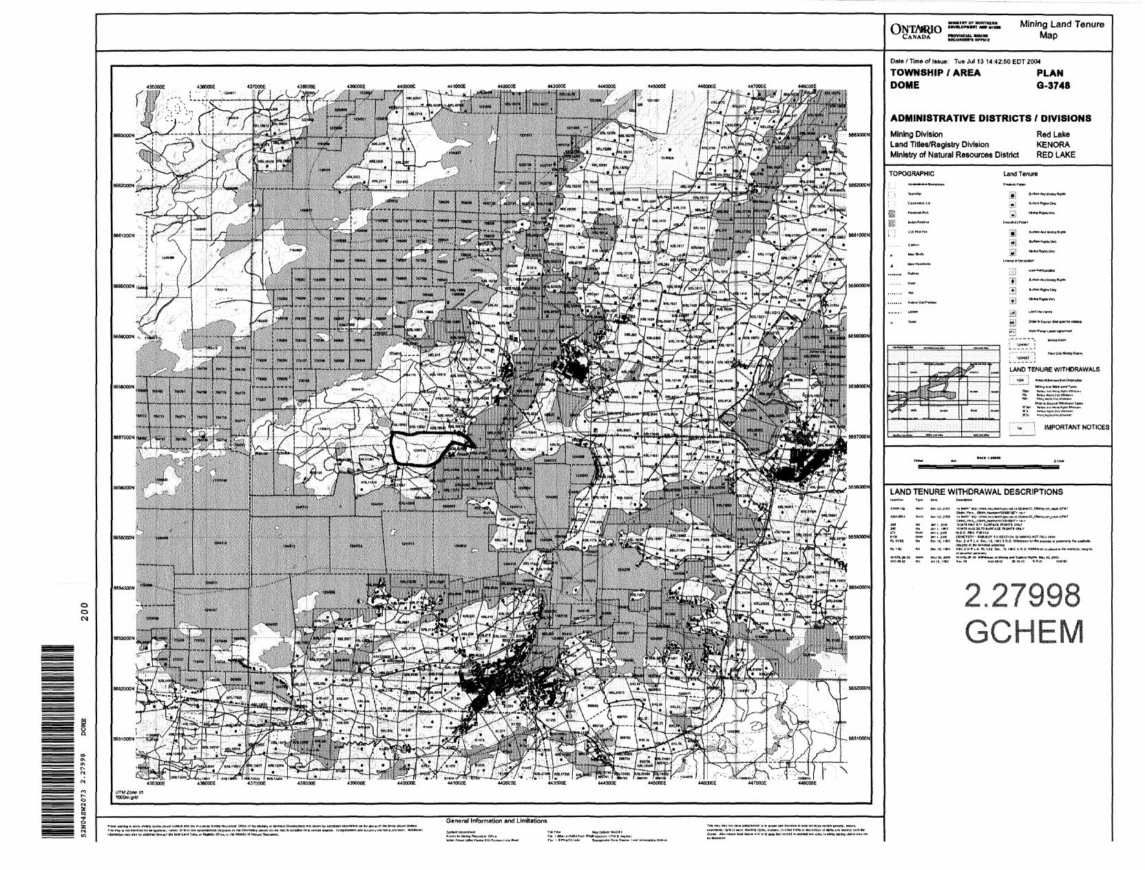
MMI GEOCHEM SURVEY REPORT CLAIM KRL 1234145 DOME TOWNSHIP RED LAKE MINING DIVISION 52N04 By Michael A. Dehn Senior Geologist, Goldcorp Inc. June 2004 52N04SW2073 2.27998 DOME 010
MMI GEOCHEM SURVEY REPORT CLAIM KRL 1234145
DOME TOWNSHIP RED LAKE MINING DIVISION
52N04
ByMichael A. Dehn Senior Geologist, Goldcorp Inc. June 2004
52N04SW2073 2.27998 DOME 010
Table of Contents
Introduction
Summary and Recommendations
Property
Property Location and Access
Instrumentation and Work Done
Interpretation
Regional Geology
Conclusions
References
Personnel
Figure l
Figure 2
Figure 3
Figure 4
Figure 5
Figure 6
Table l
Table 2
List of Figures
Location Map
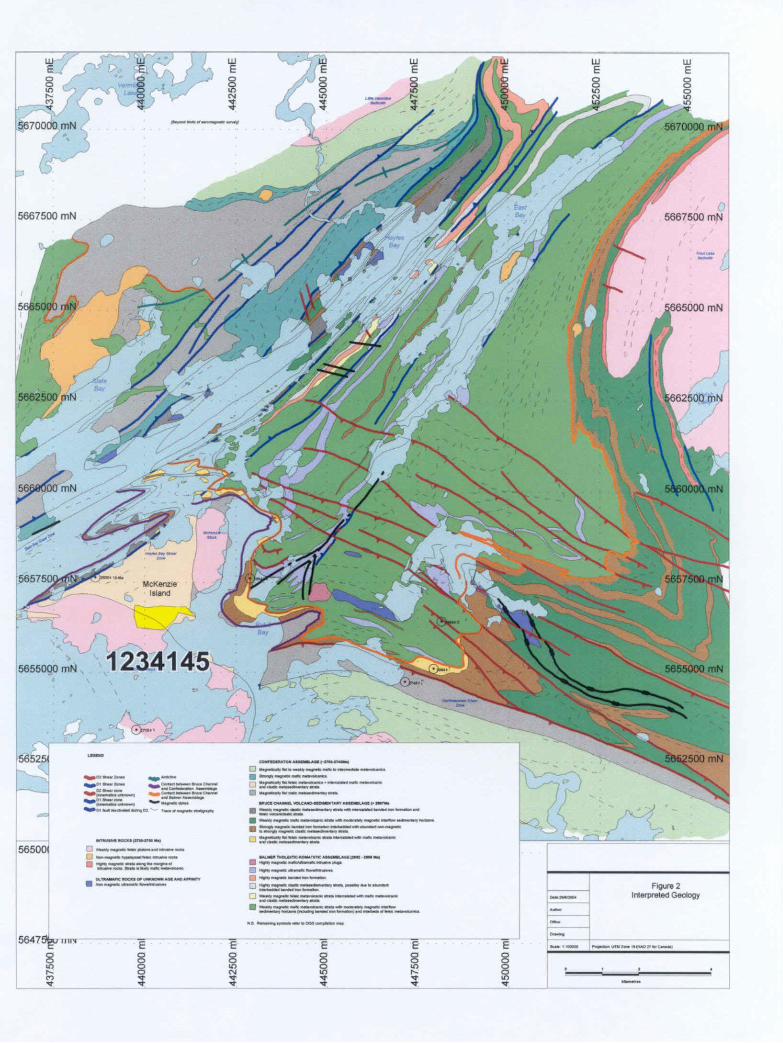
Interpreted Geology Map
Location in Dome Township Map
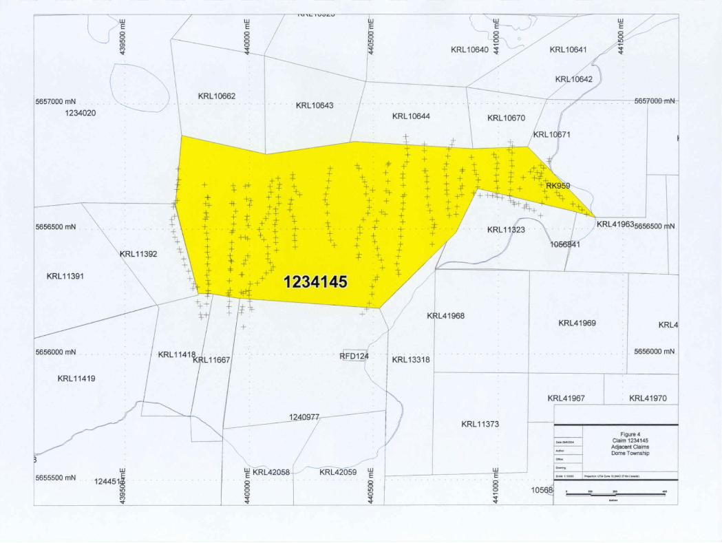
Adjacent Claims Map
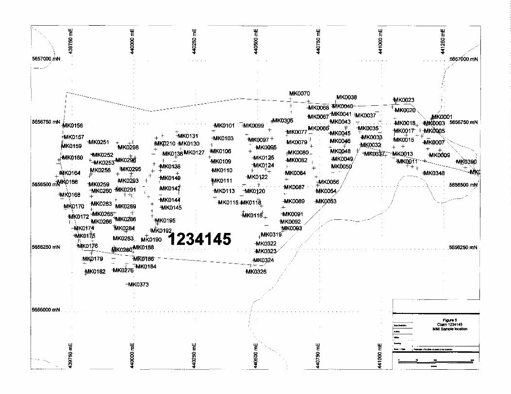
MMI Siample Location Map
Proportional Au Circle Plot Map
List of Tables and Certificates
Claim Description
Corrected Magnetometer Data
Assay Certificates
l
1
2
2
2
2
6
7
11
12
3
4
5
8
9
10
Appendix A
Appendix B

Introduction
Claim KRL 1234145 is controlled by Goldcorp Inc. It is located on McKenzie Island, in Red Lake, and is completely on land. It is an isolated claim of Goldcorp Inc. vast landholdings in the Red Lake Mining Division., and is completely within Dome Township.
Goldcorp Inc., contracted Dan Patrie Exploration Ltd to complete a GPS grid total MMI Geochem survey over claim KRL 1234145 to follow up on previous ground geophysics, prospecting and mapping completed on the property.
The following report summarizes the results of work carried out during the current program and the results obtained from the work.
Summary and Recommendations
Between July 27th and August l st,2004, an MMI Geochem survey was completed on claim KRL 1234145, on the McKenzie Island in Red Lake. Approximately 9.0 km line km of MMI samples were collected on roughly a 25 m sample spacing on line, with lines roughly 50m apart.
This area likely covers the contact between the Dome Stock to the south, and Confederation metavolcanic to metasedimentary lithologies (see figure 2) . Claim KRL 1234145 seems to be in a high strain zone along the contact of the Dome Sotck, with Confederation lithologies wedged between the Dome and McKenzie Stocks..
Claim KRL 1234145 is a strong candidate to host gold mineralization in the form of narrow quartz veins and quartz tourmaline veins.
It is recommended that the following program be carried out to complete the evaluation of the claim.
1. Completion of infill MMI geochemistry on a minimum 10m by 10m grid spacing around anomalies.
2. Completion of two 300m diamond drill hole, drilling northeast to try to intersect the contact between the Dome Stock and Confederation Assemblage.
3. Completion of a detailed compilation of the McKenzie Island area and all previous work on adjacent claims.
4. Complete a new claim inspection to properly locate the claim boundaries as they appear incorrect on the MNDM claim maps
Following completion of this work and contingent upon results then additional work would be considered to further evaluate the economic potential for gold mineralization on the claim.
Respectfully submitted
Michael A. Dehn.,Senior Geologist, Goldcorp Inc.June 28,2004
Property
The property consists of one staked claim in Dome township, Red Lake Mining Division, Red Lake, Ontario. This claim is completely on land on McKenzie Island, within Red Lake.
Table l Claim Description
Mining Claim Recording Date Units
KRL 1234145 July 4, 2000 07
TOTAL 07 Unit
Property Location and Access
Claim KRI 1234145 is located on McKenzie Island, within Red Lake, in the eastern portion of the Red Lake Greenstone Belt. The claim is accessible by watercraft in the in the spring to fall and snowmachine and motor vehicle in winter. The claim is located less than 2 km from the town of Cochenour, approximately 3 km from the town of Red Lake, l km from the town of McKenzie Island, and 7 km from the town of Balmertown. The closest road access is Highway 125, and commonly in the winter the ice road from Red Lake to Cochenour l McKenzie Island traverses the Bruce Channel between the end of Highway 125 and the claim.
Work Done
A total of 9.0 kilometres of MMI samples were taken along a GPS grid trhough the bush and adjacent to trails on McKenzie Island with 25 m station intervals. The field measurements from the GPS were downloaded to a personal computer and the sample descriptions and number added, from field notebooks. To this, MMI assay data is then merged and then used for plotting.
Interpretation
The MMI survey proved successful in finding gold geochem anomalies in the southwest portion of the claim that seems to be unrelated to contamination from old mine waste rock used a road base. As well, a linear feature is visible from the narrowing of the claim west of the main road through to the middle of the claim. This roughly parallels the Confederation l Dome Stock contact, and could well be a mineralized shear parallel to the edge of the Dome Stock, and is a worth following up with addition samples. It should be

ClaimKRL 1234145
Vermilion
ToWinnJpcg KENORA
Figure 1. Location Map
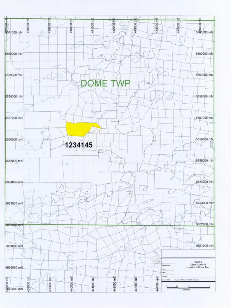
noted that the samples were all collected on the claim, however the claim location from the MDNM claims maps appears to be incorrect in some places by up to 100m or more.
Regional Geology
The Red Lake area is underlain by a 60 x 30 kilometer irregularly-shaped belt of metavolcanic and metasedimentary rocks surrounded and intruded by diapiric granitoid plutons. According to Pirie (1981), the belt consists of 2 predominantly volcanic successions; a lower tholeiitic to komaliitic sequence, and an upper calc-alkaline sequence.
The older volcanic sequence has three main types of volcanic flows: tholeiitic basalt, variolitic basalt, and komatiites (Pirie, 1981). Felsic pyroclastics with minor flows and metasediments also occur within this sequence.
The calc-alkaline sequence is more complex (Pirie, 1981). Substantially different volcanic lithologies are intimately interbedded and interdigitate laterally, suggesting extrusions of volcanics of different composition from different sources. Quartz-pyric rhyolite flows, tuffs, lapilli stones and breccias with intermixed dacitic to andesitics equivalents are abundant. Andesite to basaltic flows are common as well.
LJ-Pb dating indicates a prolonged period of volcanic activity evolving from tholeiitic to dominantly calc-alkaline affinity and spanning an interval of at least 2700 Ma (Andrews et al, 1986). The supercrustal rocks have been intruded by a variety of felsic to intermediate stocks and dykes, such as the "Howey Diorite", just east of Red Lake and the "Dome Stock." A granidiorite in the center of the batholiths to the north marks the beginning of major felsic plutonism in the belt at 2731 *fe 2717 Ma respectively, and culminated in the emplacement of the Killala - Baird and Trout Lake batholiths at approximately 2700 Ma (Andrews et al, 1986).
The structural signature of the Red Lake green stone belt is dominated by the subvertical to vertical attitude of the widespread development of a penetrative L-S fabric, the latter accompanied by a variety of related brittle to brittle-ductile features (Hugon & Schwerdtner, 1984, 1985). The regional fabric manifests in the pervasive foliation and cleavage development which in the vicinity of batholith contacts, increases in intensity to define 2-3 kilometer-wide strain aureoles of strongly deformed schistose to gneissose supracrustal rocks.
Foliation trajectories obtained from the foliation data available at the belt scale demonstrates that large and small scale conjugated trans-current shear zones developed within the supra crustal material of the belt. These sets of shear zones form discrete linear zones of high strain (deformation zones), superimposed on the regional trends. These deformation zones occur at the interface between the older and younger volcanic piles. The combined structural evidence indicates that formation of the regional foliations and conjugate systems of the deformation zones was broadly synchronous and temporarily related to the diapiric emplacement of the surrounding batholiths (Hugon Si. Schwerdtner, 1984). Past and present producing mines in the Red Lake camp occur in zones of highly altered rock near the stratigraphic top of the lower tholeiitic sequence. A few past producers located within the Dome Stock and related McKenzie Stock represent the only exceptions. The major Gold deposits of the area and the highly altered rocks
associated with them are spatially related to the large heterogenous shear systems (deformation zones), which cut across the volcanic sequences on a regional scale. Studies by Andrews et al, (1986), in the Campbell Dickenson Mines indicate that gold mineralization was broadly synchronous with the peak of thermal metamorphism but post-dated much of the carbonated alteration and occurred late in the history of shear deformation.
The combined evidence indicates that contact thermal metamorphism, shear deformation and intense hydrothermal alteration attending gold mineralization were broadly coeval and directly lined to the process of batholith emplacement.
Conclusions
The greatest potential for significant tonnages of mineralization lies within or near the contact of the Dome Stock with the adjacent assemblages. The Dome Stock, known to host very narrow but high grade quartz veins is not believed to be a high priority target, however, the contact zone between the intrusive and mafic lithologies to the north should provide an excellent geochemical and structural contact with the possibility of opening up structures parallel to the mafic lithology, and most vein systems in the area are assumed to trend almost due north. Induced polarity would not likely produce a significant response to this style of mineralization, however, a detailed VLF survey on the ice may provide additional structural information that is masked in the mag survey due to likely bedding parallel structures in the mafic lithologies.
S
Ill m
S en
UJ lil
lLU UJ
l
5657QOO,mN 5657000 mN
5656750 mN
5656500
5656250 mN
K0156
K0157
K0159
K0160
HWIK028a4. ^0190 l 2341 45
4-
4MK03pfc 'VlrWW 'HMK0043 4
4 ^i^no77MK006^...^^ \ ^ ,... 4
IVUUS" HVIK0079" HWK0046 ^^ -MK0015-MKOQ95 ~^~ 4. "^~ Twiyjyo^: 44
-J ^K0080^ .^J^^r^QQ13 ^KCW-MK0082 44- 4
-MK0084
"^ J1K0056 ?K0087 iK0054/
5656250 mN
-MK0326
4MK0373
5656000 mN
mEg
ES
UJ ui HI
grv o
FiguresClam 1234145
MMI Sample location
TMO PNIMMUTIIZM*W(NN)Z

1234145
References
Corfu, F., and Wallace, H., 1986, U-Pb Ages for Magnetism in the Red Lake Greenstone Belt, Northwestern Ontario. Canadian Journal of Earth Sciences, v.23, p27-42.
Ferguson, S. A., 1960, Part of the East Half of Dome Township, District of Kenora (Patricia Portion), Ontario Department of Mines, Preliminary Map 93, Scale l inch to 500 feet.
Horwood, H. C., 1940, Geology and Mineralization of Deposits of the Red Lake Area, Ontario Department of Mines, Annual Report, v.49, part 2, 231 p.
Hugon, H., Schwerdtner, W. M., 1984, Structural Signature and Tectonic History of Gold Bearing Deformed Rocks in Northwestern Ontario, p. 164-176 in Geoscience Research Grant Program, Summary of Research, 1983-1984, Ontario Geological Survey, Misc. 121, 252 p.
Pirie, J., 1981, Regional Geological setting in Gold Deposits in the Red Lake Area, Northwestern Ontario, in the Genesis of Archean Volcanic Hosted Gold Deposits, Ontario Geological Survey, Misc. Paper 97, P 71-93.

Field Personnel
Byran Patrie - Spanish, Ontario and Balmertown, Ontario
Brent Patrie - Elliot Lake, Ontario
Dan Patrie - Massey, Ontario

APPENDIX A
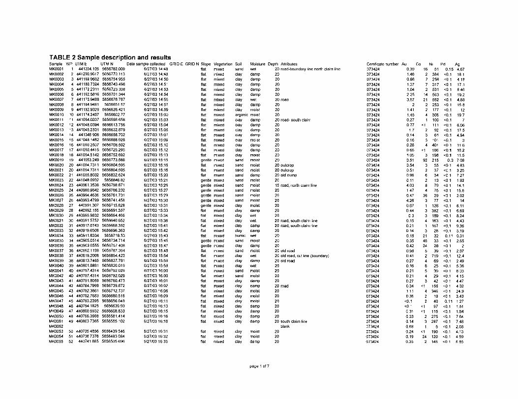
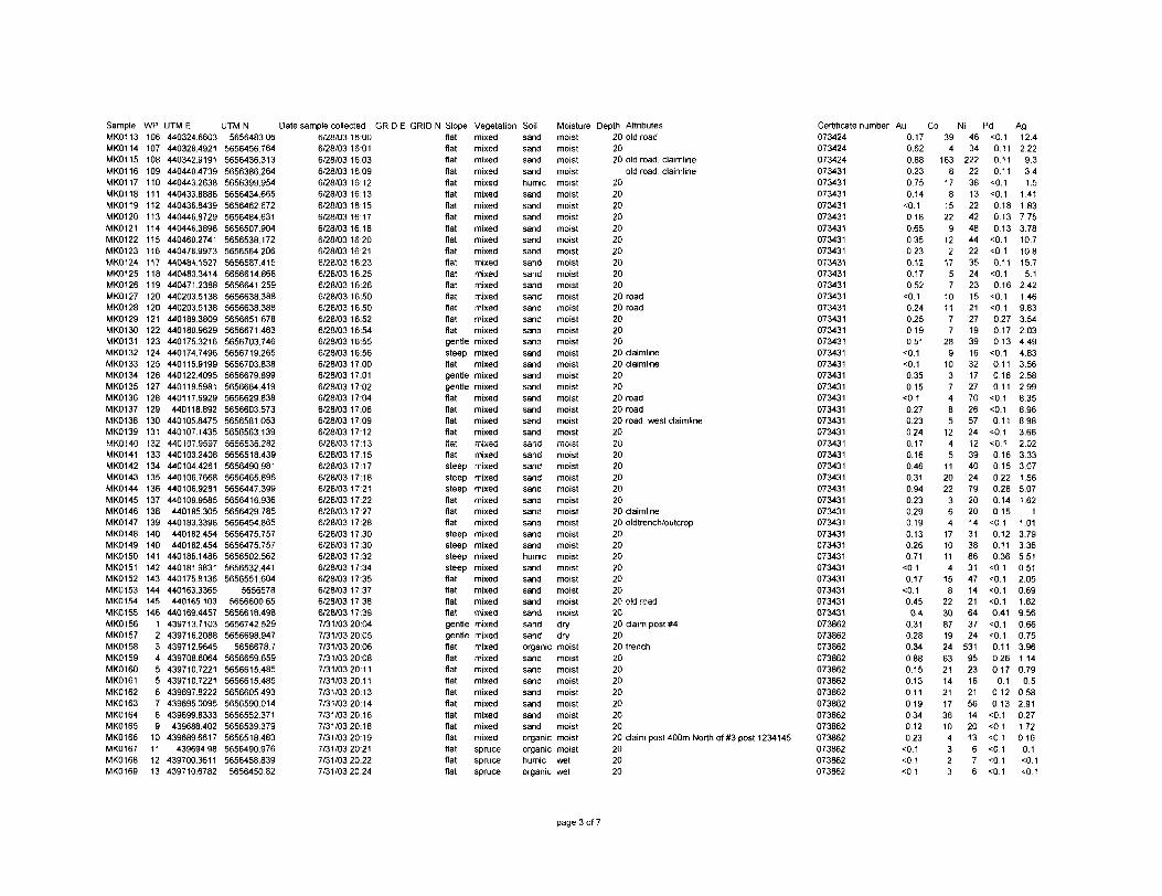
TABLE 2 Sample description and resultsSampleMK0001MK0002MK0003MK0004MK0005MK0006MK0007MK0008MK0009MK0010MK001 1MK0012MK0013MK0014MK0015MK0016MK0017MK0018MK0019MK0020MK0021MK0022MK0023MK0024MK0025MK0026MK0027MK0028MK0029MK0030MK0031MK0032MK0033MK0034MK0035MK0036MK0037MK0038MK0039MK0040MK0041MK0042MK0043MK0044MK0045MK0046MK0047MK0048MK0049MK0050MK0051MK0052MK0053MK0054MK0055
WP123456789
101112131415161718192020212223242526272829303132333435363738394040414243444546474849
505152
UTM E441204.105
441200.9617441169.9602441180.7324441172.2311441162.5816441170.9488441184.9481441192.9329441174.2407441064.0337441048.0394441045.2501
441048.906441048.1462441050.2507441050.4415441054.5142441053.249
441054.7311441054.7311441055.8032441048.0932440981.3538440990.98424409944636440993.4799
440991 .307440992.155
440995.9832440991.5752440917.0743440919.6508440911.6334440905.0514440903.0555440892.1198440819.2008440813.7465440801.8881440797.4314440797.4314440791.8059440784.7999440792.3861440792.7683440793.2395440794.1825440800.5932440798.3988440803.7365
440735.4856440736.7376
440741.885
UTM N Date sample collected GRIDE5656782.0095656770.1135656754.9555656743.4965656723.3085656701.3445656676.7875656651.57
5656626.4215656602.77
5656598.6585656613.7565656632.8795656656.7025656688.9285656708.59256567252955656752.6925656773.5885656804.5955656804.5955656832.624565684882
5656798.8715656786.2325656761.7315656741.4585656715.8285656691.3575656664.46656566406525656668.3525656696.3635656718.53
5656734.7145656757.4085656787.3645656854.4235656837.7815656820.0195656792.0295656792.0295656760.4735656739.6725656712.7375656680.5165656656049
5656639.935656608.8335656581.4145656555.102
5656439.54656564830845656505.696
6/27/03 14:486/27/03 14:486/27/03 14:506/27/03 14:516/27/03 14:536/27/03 14:546/27/03 14:566/27/03 14:576/27/03 14:596/27/03 15:006/27/03 15:036/27/03 15:046/27/03 15:066/27/03 15:076/27/03 15:096/27/03 15:106/27/0315:126/27/03 15:136/27/03 15:156/27/03 15:166/27/03 15:166/27/03 15:206/27/03 15:216/27/03 15:266/27/03 15:276/27/03 15 296/27/03 15:306/27/03 15:316/27/03 15:336/27/0315:346/27/03 15:366/27/0315:416/27/03 15:426/27/0315:436/27/0315:456/27/03 15:476/27/03 15:486/27/03 15:546/27/03 15:586/27/03 15:586/27/03 16:006/27/03 16:006/27/03 16:016/27/03 16:026/27/03 16:066/27/03 16:096/27/0316:116/27/0316:136/27/0316:156/27/03 16:166/27/03 16:18
6/27/03 16:316/27/03 16:326/27/03 16:33
GRID N Slopeflatflatflatflatflatflatflatflatflatflatflatflatflatflatflatflatflatflatgentleflatflatflatgentlegentlegentlegentlegentlegentleflatflatflatflatflalflatgentlegentleflatflatflatflatflatflatflatflatflatflatflatflatflatflatflat
flatflatflat
Vegetation Soilmixedmixedmixedmixedmixedmixedmixedmixedmixedmixedmixedmixedmixedmixedmixedmixedmixedmixedmixedmixedmixedmixedmixedmixedmixedmixedmixedmixedmixedmixedmixedmixedmixedmixedmixedmixedmixedmixedmixedmixedmixedmixedmixedmixedmixedmixedmixedmixedmixedmixedmixed
mixedmixedmixed
sandclaydayclaydaydaydaydaydayorganicdaydaydaydaydaydaydaydaysandsandsandsandsandsandsandsandsanddaydaydaydaydaydayhumicsanddaysanddaydaydaysandsanddaydaydaydaydaydaydaydayday
daydayday
Moisturewetdampdampdampdampdampwetdampmoistmoistdampdampdampdampmoistdampdampmoistmoistmoistmoistdampmoistmoistmoistmoistmoistmoistdampwetwetdampdampwetmoistdampmoistwetdampwetmoistmoistdampdampmoistmoistmoistdampdampdampdamp
moistmoistdamp
Depth Attributes20 road-boundary line north daim line202020202020 road20202020 road- south claim202020202020202020 outcrop20 outcrop20 old dump2015 road, north daim line20202020202020 road, south claim line20 road, south daim line2020202020 old road20 old road, cut line (boundary)20 old road2020202020 road20202020202020 south daim line
blank202020
Certificate number Au Co073424073424073424073424073424073424073424073424073424073424073424073424073424073424073424073424073424073424073424073424073424073424073424073424073424073424073424073424073424073424073424073424073424073424073424073424073424073424073424073424073424073424073424073424073424073424073424073424073424073424073424073424073424073424073424
0.391.460.861.371.042253.57
21.411.450.270.77
1.70.140.160.280.661.050.510.540.510.960.114.031.470.474.260.670.44
0.30.150.210.140.180.350.420.980.410.270.160.210.210.270.341.110.36
O.1O.10.310.330.140.680.240.190.35
162272
1421
2241
:1
2334
si
392
326284
363133413
214624
5248543
el
422
si si
23
1<•\
242
Ni51
3842583175315635522531773061001119261
101401186198215
5537341379752977
1283821891631672832332839
7196925392942
156346
194097
115275287
5190120146
Pd Ag0.15 4.67
O.1 18.1O.1 4.18O.1 17.101 8.46O.1 19.2O.1 4.88O.1 15.8O.1 120.1 19.7O.1 7 sO.1 6.06O.1 17.5O.1 4.94O.1 3O.1 11.6O.1 102O1 11.5
0.3 7.080.1 4.83 sO.1 3.25O.1 7.27O.1 1.82O.1 14.1^.1 15.6O.I 2.020.1 14O.1 6.11O.1 6.69O.1 8.24O.1 4,43O.1 9.36O.1 3.190.11 0.31
O. 2.650. 2O. 2.07O. 12.4O. 2.49O.1 5.360.1 8.03O.1 4.15O.1 4.47O.1 4.32O.1 24.9O.1 3.430.11 1.27
O.1 1.51O.1 1.84O.1 7.64O.1 7.48 sO.1 2.08O. 4.13O.1 4.590.1 6.85
page 1 of 7
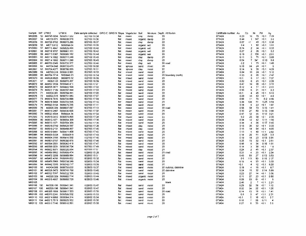
SampleMK0056MK0057MK0058MK0059MK0060MK0061MK0062MK0063MK0064MK0065MK0066MK0067MK0068MK0069MK0070MK0071MK0072MK0073MK0074MK0075MK0076MK0077MK0078MK0079MK0080MK0081MK0082MK0083MK0084MK0085MK0086MK0087MK0088MK0089MK0090MK0091MK0092MK0093MK0094MK0095MK0096MK0097MK0098MK0099MK0100MK0101MK0102MK0103MK0104MK0105MK0106MK0107MK0108MK0109MK0110MK0111MK0112
WP53545556575859606061626364656667686970717273747576777879808081828384858687888990919293949596979899
100100101102103104105
UTM E440745.0294
440735.871440726.8702
440719.612440715.4847440716.9757440713.5387440714.1682440714.1682440709.5349
440704.648440704.4377
440703.318440704.3714440629.9023
440631.03440632.2934440635.3677440637.7109440634.381440622.515
440618.7816440618.5894440620.5154
440625.339440619.2487440620.4504440619.0412440613.1071440613.1071440618.0749440610.2131440610.6491440609.5334440604.3785440601.0757440594.3551440599.3231440602.8971440496.9802440472.3209440465.4056440456.5969440442.3355
440434.586440326.5472440322.5397
440320.329440315.4937
440309.196440309.196
440305.1608440313.2241440314.6966440315.75194403197146
UTM N Date sample collected GRIDE565651 ^.5925656538.5795656573.2865656596.04
5656629.4985656661.1015656689.1825656711.2495656711.2495656733.3775656733.4335656780.5685656813.991
5656840.235656870.32
5656870.3075656849.4115656822.5285656797.4445656769.4415656751.0835656720.6985656703.9955656675.3365656637.0975656630.605
5656604.345656579.8955656554.3095656554.3095656528.5975656498.8575656471.408
565643985656416.5925656390.9755656362.4155656336.7045656320.5545656656.4745656669.8845656689.6525656708.2495656743.0175656755.6355656743.7585656722.3265656693.7145656665.729
5656641.3415656641.3415656617.5235656599.5325656564.3145656525.5225656510.561
6/27/03 16:346/27/0316:366/27/03 16:376/27/03 16:396/27/03 16:406/27/03 16:426/27/03 16:446/27/03 16:456/27/03 16:456/27/03 16:466/27/03 16:506/27/03 16:516/27/03 16:536/27/03 16:546/27/03 16:586/27/03 16:596/27/03 17:016/27/03 17:026/27/03 17:036/27/03 17:056/27/03 17:076/27/03 17:096/27/03 17:106/27/0317:116/27/0317:136/27/03 17:326/27/03 17:336/27/03 17:346/27/0317:366/27/03 17:366/27/0317:386/27/03 17:406/27/03 17:426/27/0317:436/27/03 17:456/27/0317:466/27/0317:476/27/03 17:496/27/03 17:516/28/03 15:286/28/03 15:316/28/03 15:326/28/03 15:346/28/03 15:356/28/03 15:376/28/03 15:426/28/03 15:436/28/03 15:446/28/0315:46
6/28/0315:476/28/0315:476/28/0315:506/28/0315:536/28/03 15:546/28/03 15:566/28/03 15:58
GRID N Slope Vegetation Soilflatflatflatflatflatflatflatflatflatflatflatflatflatflatflatflatflatflatflatflatflatflatflatfatflatflatflatflatflatflatflatflatflatflatflatflatflatflatflatflatflatflatfatfatfatfatfatfatfat
fatflatflatflatflatflatfat
mixedmixedmixedmixedmixedmixedmixedmixedmixedmixedsprucesprucemixedmixedmixedmixedmixedmixedmixedmixedmixedmixedmixedmixedmixedmixedmixedmixedmixedmixedmixedmixedmixedmixedmixedmixedmixedmixedmixedmixedmixedmixedmixedmixedmixedmixedmixedmixedmixed
mixedmixedmixedmixedmixedmixedmixed
dayorganicclayorganicorganicorganicorganicdaydaydaysanddaysandsandsandsandsandsandsandsandsandsandsandsandsandsandsandsandsandsanddaydaysandsandsandsandsandsanddaysandsandsandsandsandsandsandsandorganicorganic
sandsandsandsandsandsandsand
Moisturedampdampdampwetwetwetwetdampdampwetmoistmoistmoistmoistmoistmoistmoistmoistmoistmoistmoistmoistmoistmoistmoistmoistmoistmoistmoistmoistmoistmoistmoistmoistmoistmoistmoistmoistmoistmoistmoistmoistmoistmoistmoistmoistmoistmoistmoist
moistmoistmoistmoistmoistmoistmoist
Depth Attributes20202020202020202020 road20202020 boundary (north)2020202020202020202020 road202020202020202020202020202020 road2020202020 outcrop, daimline20 daimline202020
blank202020 road20202020
Certificate number Au Co Ni Pd073424073424073424073424073424073424073424073424073424073424073424073424073424073424073424073424073424073424073424073424073424073424073424073424073424073424073424073424073424073424073424073424073424073424073424073424073424073424073424073424073424073424073424073424073424073424073424073424073424073424073424073424073424073424073424073424073424
0.290.440.570.4
0.740.270.190.110.540.2
0.180.140.240.33O.10.220.470.120.56O.10.290.660.340.180.560.330.470.2
0.340.340,130.160.130.180.190.250.980.140.240.310.430.6
0.15O.10.180.240.230.110.282.460.290.320.140.5
O.10.180.27
161
*1
1222371
64910856194641011
1346
5427122312435145
2914136324
59113444152727532
3234133578
751474992343815676
541752435243517203617212643705123736035384236325440512332343845232780201218321420617
39321847162833
O.O.O.O.0.O.0.1O.10.130.1O.1O.1O.1O.1O.1O.1O.1O.1O.1O.1O.1
0.20.25O.10.130.130.12O.0.110.17O1O.10.10.250.13O.10.18O.1O.1O.10.130.16O.10.1O.10.14O.1O.1O.1O.1O.10.1O.1O.1O.10.11O.1
Ag7.293.6
0.361.610.330.2
2.613896.81.45
54.295.122427.372263.722.015.3
5.134.9
4.883.641.871.413.983.212.051.990.653.334.052.823.9
0.912.611.011.9
2.372.343.532.073.336.358.7
5.693.060.85
52.211.121.261.412.312.74
5.6
page 2 of 7
SampleMK0113MK0114MK0115MK0116MK0117MK0118MK0119MK0120MK0121MK0122MK0123MK0124MK0125MK0126MK0127MK0128MK0129MK0130MK0131MK0132MK0133MK0134MK0135MK0136MK0137MK0138MK0139MK0140MK0141MK0142MK0143MK0144MK0145MK0146MK0147MK0148MK0149MK0150MK0151MK0152MK0153MK0154MK0155MK0156MK0157MK0158MK0159MK0160MK0161MK0162MK0163MK0164MK0165MK0166MK0167MK0168MK0169
WP106107108109110111112113114115116117118119120120121122123124125126127128129130131132133134135136137138139140140141142143144145146
1234556789
10111213
UTM E440324.6603440328.4921440342.9191440440.4739440443.2638440433.8888440436.8439440446.8729440446.3896440460.2741440478.9973440484.1527440483.3414440471.2388440203.5138440203.5138440189.3809440180.9629440175.3216440174.7496440115.9199440122.4095440119.5981440117.6929440118.892
440105.8475440107.1435440107.9597440103.2408440104.4261440106.7668440106.9281440109.9585
440185.305440183.3398
440182.454440182.454
440186.1486440181.9831440175.8136440163.3365440165103
440169.4457439713.7103439716.2088439712.9645439708.6064439710.7221439710.7221439697.8222439695.0095439699.8333439688.402
439689.6617439694.98
439700.3611439710.6782
UTMN Date sample collected GRIDE5656483.06
5656456.7645656436.3135656386.2645656399.9545656434.6655656462.6725656484.6315656507.9045656538.1725656564.2065656587.4155656614.8685656641.2595656638.3885656638.3885656651.6785656671.4635656703.7465656719.2655656703.8385656679.8995656664.4195656629.8385656603.5735656581.0535656563.1395656535.2825656518.4395656490.9815656465.8965656447.3995656416.9365656429.7855656454.8655656475.7575656475.7575656502.5625656532.4415656551.604
5656578565660065
5656618.4985656742.5295656698.947
5656678.75656659.6595656615.4855656615.4855656605.4935656590.0145656552.3715656539.3795656518.4835656490.9765656468.8395656450.82
6/28/03 16:006/28/0316:016/28/03 16:036/28/0316:096/28/0316:126/28/0316:136/28/03 16:156/28/03 16:176/28/03 16:186/28/03 16:206/28/03 16:216/28/03 16:236/28/03 16:256/28/03 16:266/28/03 16:506/28/03 16:506/28/03 16:526/28/03 16:546/28/03 16:556/28/03 16:566/28/03 17:006/28/03 17:016/28/03 17:026/28/03 17:046/28/03 17:066/28/0317:096/28/0317:126/28/0317:136/28/03 17:156/28/0317:176/28/03 17:186/28/03 17:216/28/03 17:226/28/03 17:276/28/03 17:286/28/03 17:306/28/03 17:306/28/03 17:326/28/03 17:346/28/03 17:356/28/03 17:376/28/03 17:386/28/03 17:397/31/03 20:047/31/03 20:057/31/03 20:067/31/03 20:087/31/0320:117/31/0320:117/31/03 20:137/31/0320:147/31/0320:167/31/0320:187/31/0320:197/31/0320:217/31/0320:227/31/0320:24
GRID N Slopeflatflatflatflatflatflatflatflatflatflatflatflatflatflatflatflatflatflatgentlesteepflatgentlegentleflatflatflatflatflatflatsteepsteepsteepflatflatflatsteepsteepsteepsteepflatflatflatflatgentlegentleflatflatflatflatflatflatflatflatflatflatflatflat
Vegetation Soilmixedmixedmixedmixedmixedmixedmixedmixedmixedmixedmixedmixedmixedmixedmixedmixedmixedmixedmixedmixedmixedmixedmixedmixedmixedmixedmixedmixedmixedmixedmixedmixedmixedmixedmixedmixedmixedmixedmixedmixedmixedmixedmixedmixedmixedmixedmixedmixedmixedmixedmixedmixedmixedmixedsprucesprucespruce
sandsandsandsandhumicsandsandsandsandsandsandsandsandsandsandsandsandsandsandsandsandsandsandsandsandsandsandsandsandsandsandsandsandsandsandsandsandhumicsandsandsandsandsandsandsandorganicsandsandsandsandsandsandsandorganicorganichumicorganic
Moisturemoistmoistmoistmoistmoistmoistmoistmoistmoistmoistmoistmoistmoistmoistmoistmoismoismoismoismoismoismoismoismoistmoistmoistmoistmoistmoistmoistmoismoismoismoismoismoismoismoismoismoismoistmoistmoistdrydrymoistmoistmoistmoistmoistmoistmoistmoistmoistmoistwetwet
Depth Attributes20 old road2020 old road, daimline
old road, daimline2020202020202020202020 road20 road20202020 daimline20 daimline202020 road20 road20 road, west daimline2020202020202020 daimline20 oldtrench/outcrop20202020202020 old road2020 daim post *42020 trench2020202020202020 daim post 400m North of #3 post 1234145202020
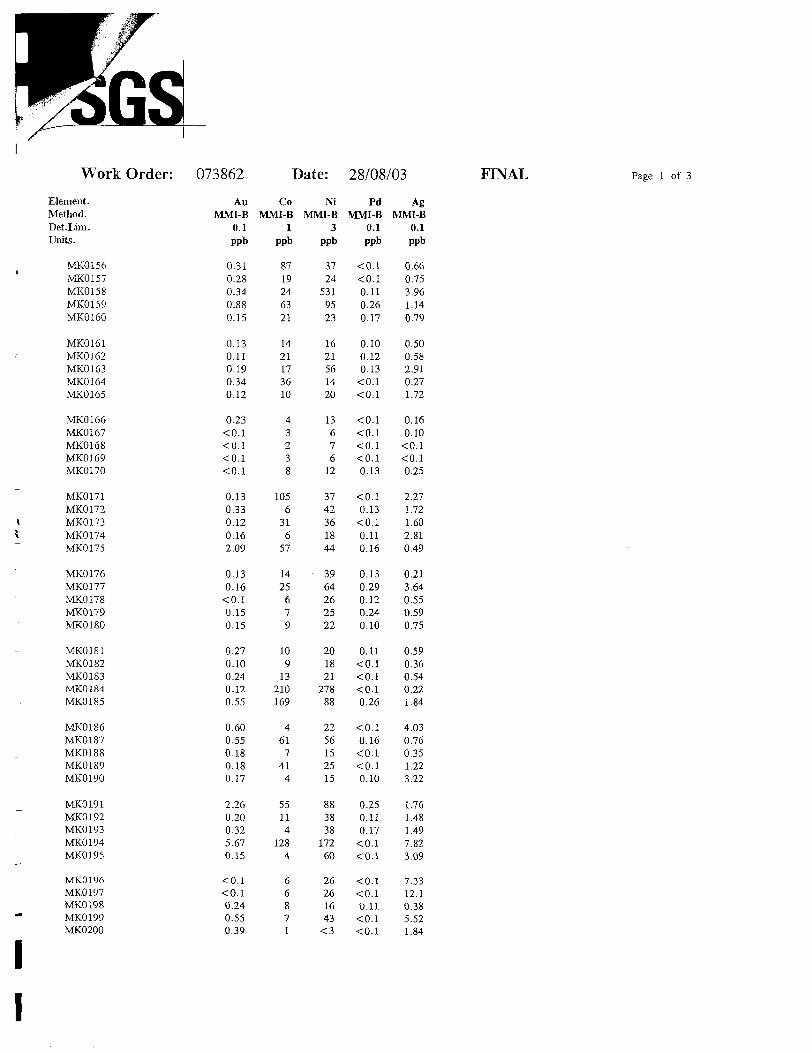
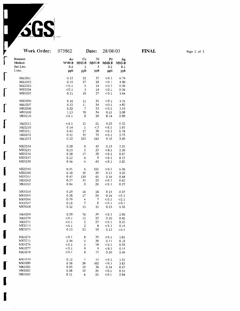
Certificate number Au Co073424073424073424073431073431073431073431073431073431073431073431073431073431073431073431073431073431073431073431073431073431073431073431073431073431073431073431073431073431073431073431073431073431073431073431073431073431073431073431073431073431073431073431073862073862073862073862073862073862073862073862073862073862073862073862073862073862
0.170.620.880.230.750.14
O.10.180.650.350.230.120.170.52
O.10.240.250.190.51
O.1O.10.350.15
O.10.270.230.240.170.160.460.310.940.230.290.190.130.260.71
O.10.17
O.10.450.4
0.310.280.340.880.150.130.110.190.340.120.23
O.1O.1O.1
394
1638
178
1522
912
217
57
101177
289
1037485
1245
112022
364
1710114
158
2230871924632114211736104323
Ni4634
222223813224248442235242315212719391632172770265724123940247920201431386631471421643724
5319523162156142013676
Pd AgO.1 12.40.11 2.220.11 9.30.11 3.4
O.1 1.5O.1 1.410.18 1.830.13 7.750.13 3.78
O.1 10.7O.1 10.80.11 15.7
0.1 5.10.16 2.42
O.1 1.46O.1 9.830.27 3.540.17 2.030.13 4.49
O.1 4.830.11 3.560.16 2.580.11 2.99
O.1 8.35O.1 8.960.11 8.98
O.1 3.66O.I 2.020.16 3.330.15 3.070.22 1.560.28 5.070.14 1.620.15 1
0.1 1.010.12 3.790.11 3.360.36 5.51
O.1 0.51O.1 2.05O.1 0.69O.I 1.620.41 9.56
O.1 0.66O.1 0.750.11 3.960.26 1.140.17 0.79
0.1 0.50.12 0.580.13 2.91
O.1 0.27O.1 1.72O.1 0.160.1 0.1O.1 O.1O.1 0. 1
page 3 of 7
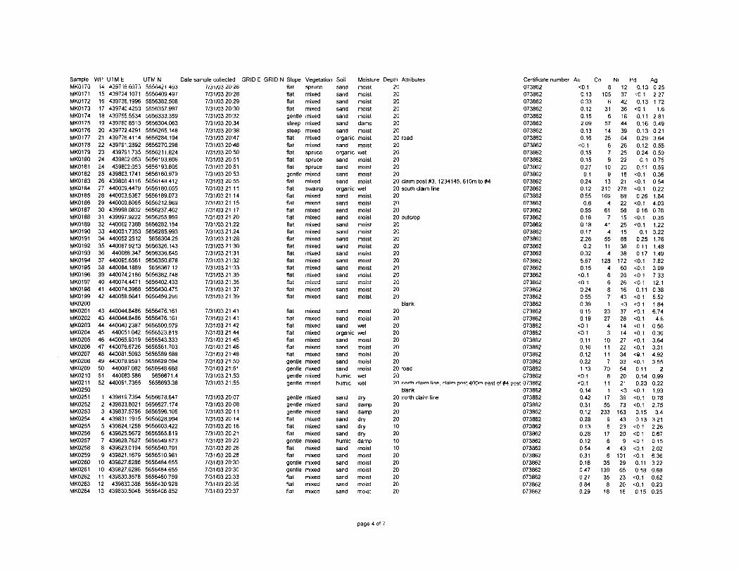
SampleMK0170MK0171MK0172MK0173MK0174MK0175MK0176MK0177MK0178MK0179MK0180MK0181MK0182MK0183MK0184MK0185MK0186MK0187MK0188MK0189MK0190MK0191MK0192MK0193MK0194MK0195MK0196MKQ197MK0198MK0199MK0200MK0201MK0202MK0203MK0204MK0205MK0206MK0207MK0208MK0209MK0210MK021 1MK0250MK0251MK0252MK0253MK0254MK0255MK0256MK0257MK0258MK0259MK0260MK0261MK0262MK0263MK0264
WP141516171819202122232424252627282930313233343536373839404142
4343444546474849505152
123456789
1010111213
UTM E**jy/ IO.DU/ J439724.1071439736.1996439740.4253439755.5534439760.8513439772.4291439776.4114439791.2892439791.735439802.053439802.053
439803.1741439806.4116440009.4479440003.5367440000.8065439998.0832439997.9222440002.7388440031.7353440052.2512440067.9213440088.347
440095.6561440084.1889440074.2186440074.4471440074.3968440058.5641
440044.8486440044.8486440040.2387
440051.042440065.9319440076.6726440081.5093440078.9591440087.082440083.586
440091.7365
439819.7394439833.8021439837.5756439831.1915439824.1258439825.5672439828.7627439823.0194439821.1679439827.6286439827.6286439830.3578
439830.386439830.5046
UTM N Date sample collected GRID EDDD04*; i.iy j5656409.4975656382.5085656357.9975656333.3595656304.0635656265.1485656284.1945656270.2985656211.8245656193.8065656193.8065656160.9795656148.4125656180.0555656189.0735656212.9695656237.4625656255.9595656282.1545656285.993
5656304.255656326.1435656336.6455656350.878
5656367.125656382.7485656402.4335656430.4755656459.296
5656476.1615656476.1615656500.0795656523.8185656543.3335656561.7035656589.6885656629.0945656648.688
5656671.45656693.38
5656678.6475656627.1745656596.1065656628.9945656603.4225656565.8195656549.6735656540.7915656510.9815656484.6555656484.6555656460.7595656430.9285656408.852
7/31/03 20:267/31/0320:287/31/0320:297/31/0320:307/31/03 20:327/31/03 20:347/31/03 20:387/31/03 20:477/31/03 20:487/31/03 20:507/31/03 20:517/31/03 20:517/31/03 20:537/31/03 20:557/31/0321:117/31/0321:147/31/0321:157/31/0321:177/31/0321:207/31/0321:227/31/0321:247/31/0321:287/31/0321:307/31/0321:317/31/0321:327/31/0321:337/31/0321:357/31/0321:367/31/0321:377/31/0321:39
7/31/0321:417/31/0321:417/31/0321:427/31/0321:447/31/0321:457/31/0321:467/31/0321:487/31/0321:507/31/0321:517/31/0321:537/31/0321:55
7/31/03 20:077/31/0320:087/31/0320:117/31/0320:147/31/0320:167/31/03 20:217/31/03 20:227/31/03 20:267/31/0320:287/31/0320:307/31/0320:307/31/03 20:337/31/0320:357/31/03 20:37
GRID N Slopeflatflatflatflatgentlesteepsteepflatflatflatflatflatgentleflatflatflatflatflatflatflatflatflatflatflatflatflatflatfiatflatflat
flatflatflatflatflatflatflatgentlegentlegentlegentle
gentlegentlegentleflatflatflatgentleflatflatgentlegentleflatflatflat
Vegetation Soil Moisturesprucemixedmixedmixedmixedmixedmixedmixedmixedsprucesprucesprucemixedmixedswampmixedmixedmixedmixedmixedmixedmixedmixedmixedmixedmixedmixedmixedmixedmixed
mixedmixedmixedmixedmixedmixedmixedmixedmixedmixedmixed
mixedmixedmixedmixedmixedmixedmixedmixedmixedmixedmixedmixedmixedmixed
sand moistsand moistsand moistsand moistsand moistsand dampsand moistorganic moistsand moistorganic wetsand moistsand moistsand moistsand moistorganic wetsand moistsand moistsand moistsand moistsand moistsand moistsand moistsand moistsand moistsand moistsand moistsand moistsand moistsand moistsand moist
sand moistsand moistsand wetorganic wetsand moistsand moistsand moistsand moistsand moisthumic wethumic wet
sand drysand dampsand dampsand drysand drysand dryhumic dampsand moistsand moistsand moistsand moistsand moistsand moistsand moist
Depth Attributes2020202020202020 road2020202020
Certificate number Au Co Ni073862073862073862073862073862073862073862073862073862073862073862073862073862
20 claim post #3, 1234145, 610m to #4 07386220 south claim line20202020 outcrop2020202020202020202020
blank202020202020202020 road2020 north claim line,
blank20 north claim line20202010201010202020202020
073862073862073862073862073862073862073862073862073862073862073862073862073862073862073862073862073862073862073862073862073862073862073862073862073862073862073862
claim post 400m east of #4 post 073862073862073862073862073862073862073862073862073862073862073862073862073862073862073862073862
0.10.130.330.120.162.090.130.16
O.10.150.150.27
0.10.240.120.55
0.60.550.180.180.172.260.2
0.325.670.15
O.10.10.240.550.390.150.19
O.1O.10.110.160.120.221.13
O.1O.I0.140.420.310.120.280.130.280.120.540.310.180.470.270.840.29
8105
631
6571425
679
109
13210169
461
741
455114
128466871
2327
43
101111
770
811
11755
23395
17646
3513935
818
1237423618443964262522201821
278882256152515883838
1726026261643^3728141427223433542021^3973
163432320
943
1012965232016
Pd Ag0.13 0.25
0.1 2.270.13 1.72
O.1 1.60.11 2.810.16 0.490.13 0.210.29 3.640.12 0.550.24 0.59
0.1 0.750.11 0.59
O,1 0.36O.1 0.54O.1 0.220.26 1.84
O.1 4.030.16 0.76
O.1 0.35O.1 1.22
0.1 3.220.25 1.760.11 1.480.17 1.49
O.1 7.82O.1 3.09O.1 7.33O.i 12.10.11 0.38
O.1 5.52O.1 1.84O.1 6.740.1 4.80.1 0.56O.1 0.360.1 3.640.1 3.31^.1 4.920.1 3.550.11 20.14 0.990.23 0.22
O.1 1.93O.1 0.780.1 2.750.15 3.40.13 3.21
O.1 2.26O.1 0.670.1 0.150.1 2.02O.1 6.360.11 3.220.18 0.68
O.1 0.62O.1 0.230.15 0.25
page 4 of 7
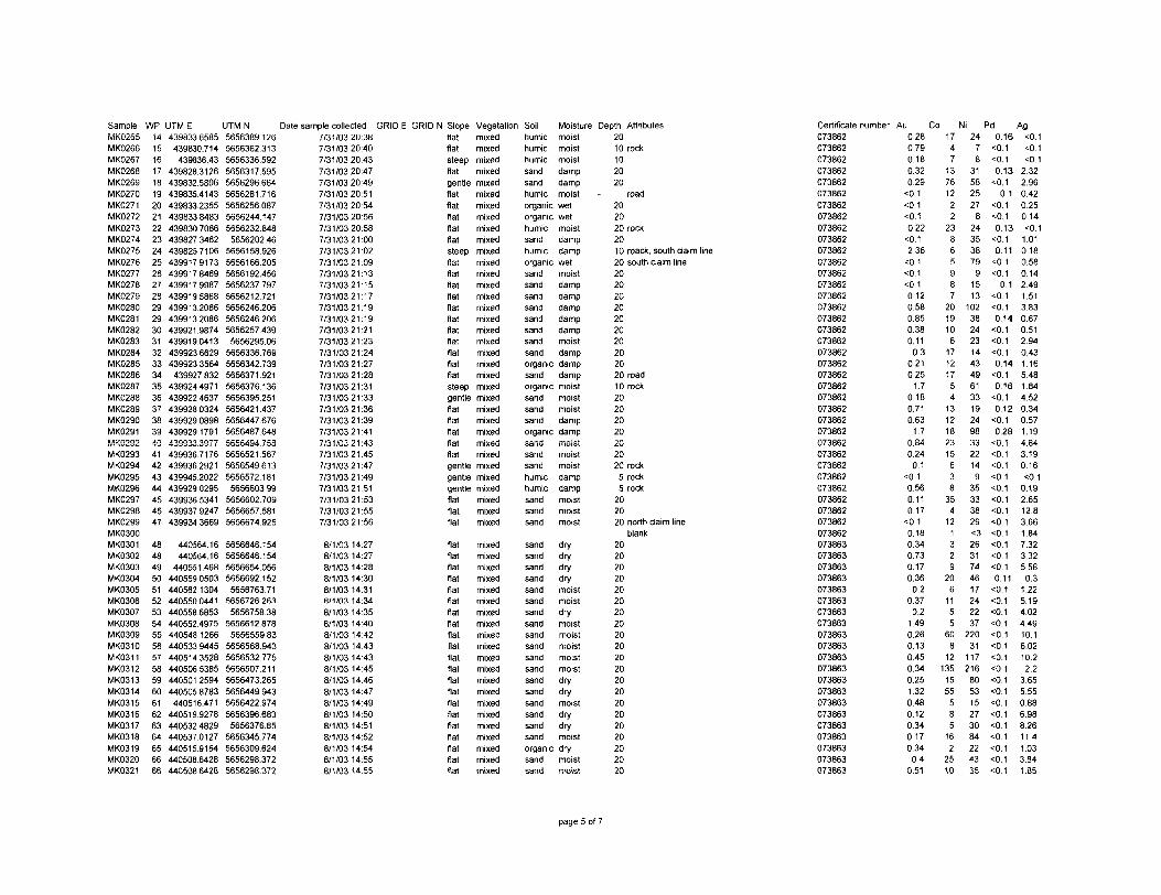
SampleMK0265MK0266MK0267MK0268MK0269MK0270MK0271MK0272MK0273MK0274MK0275MK0276MK0277MK0278MK0279MK0280MK0281MK0282MK0283MK0284MK0285MK0286MK0287MK0288MK0289MK0290MK0291MK0292MK0293MK0294MK0295MK0296MK0297MK0298MK0299MK0300MK0301MK0302MK0303MK0304MK0305MK0306MK0307MK0308MK0309MK0310MK031 1MK0312MK0313MK0314MK0315MK0316MK0317MK0318MK0319MK0320MK0321
WP1415161718192021222324252627282929303132333435363738394041424344454647
484849505152535455565758596061626364656666
UTM E439833.6585439830.714
439836.43439828.3126439832.5806439835.4143439833.2355439833.8483439830.7086439827.3462439825.7106439917.9173439917.8469439917.9987439919.5868439913.20864399132086439921.9874439919.0413439923.6629439923.3564439927832
439924.4971439922.4637439928.0324439929.0898439929.1791439933.3977439936.7176439936.2921439945.2022439929.0295439936.5341439937.9247439934.3669
440564.16440564.16
440551.468440559.0503440562.1304440550 0441440558.6853440552.4975440548.1266440533.9445440514.3528440506.5385440501.2594440505.8783
440516.471440519.9278440532.4829440537.0127440515.9164440508.6428440508.6428
UTM N Date sample collected GRID E5656389. 1265656362.3135656336.5925656317.5955656296.6645656281.7165656256.0875656244.1475656232.8485656202.46
5656158.9265656166.2055656192.4565656237.7975656212.7215656246.2065656246.2065656257.439
5656295.065656336.7695656342.7395656371.9215656376.1365656395.2515656421.4375656447.6765656487.6485655494.7585656521.5675656549.6135656572.1815656603.99
5656602.7095656657.5815656674.925
5656646.1545656646.1545656654.0565656692152
5656763.715656726263
5656758.385656612.878
5656559.835656568.9435656532.7755656507.2115656473.2655656449.9435656422.9745656396.6835656376.85
5656345.7745656309.6245656298.3725656298.372
T0 1/03 20: 387/31/03 20:407/31/0320:437/31/0320:477/31/0320:497/31/0320:517/31/0320:547/31/0320:567/31/0320:587/31/0321:007/31/0321:027/31/0321:097/31/0321:137/31/0321:157/31/0321:177/31/0321:197/31/0321:197/31/0321:217/31/0321:237/31/0321:247/31/0321:277/31/0321:287/31/0321:317/31/0321:337/31/0321:367/31/0321:397/31/0321:417/31/0321:437/31/0321:457/31/0321:477/31/0321:497/31/0321:517/31/0321:537/31/0321:557/31/0321:56
8/1/03 14:278/1/03 14:278/1/03 14:288/1/03 14:308/1/03 14:318/1/03 14:348/1/03 14:358/1/03 14:408/1/03 14:428/1/03 14:438/1/03 14:438/1/03 14:458/1/03 14:468/1/03 14:478/1/03 14:498/1/03 14:508/1/03 14:518/1/03 14:528/1/03 14:548/1/03 14:558/1/03 14:55
GRID N Slopeflatflatsteepflatgentleflatflatflatflatflatsteepflatflatflatflatflatflatflatflatflatflatflatsteepgentleflatflatflatfiatflatgentlegentlegentleflatflatflat
flatflatflatflatflatflatflatflatflatflatflatflatflatflatflatflatflatflatflatflatflat
Vegetation Soilmixedmixedmixedmixedmixedmixedmixedmixedmixedmixedmixedmixedmixedmixedmixedmixedmixedmixedmixedmixedmixedmixedmixedmixedmixedmixedmixedmixedmixedmixedmixedmixedmixedmixedmixed
mixedmixedmixedmixedmixedmixedmixedmixedmixedmixedmixedmixedmixedmixedmixedmixedmixedmixedmixedmixedmixed
humichumichumicsandsandhumicorganicorganichumicsandhumicorganicsandsandsandsandsandsandsandsandorganicsandorganicsandsandsandorganicsandsandsandhumichumicsandsandsand
sandsandsandsandsandsandsandsandsandsandsandsandsandsandsandsandsandsandorganicsandsand
Moisture Depth Attributesmoistmoistmoistdampdampmoistwetwetmoistdampdampwetmoistdampdampdampdampdampmoistdampdampdampmoistmoistmoistdampdampmoistmoistmoistdampdampmoistmoistmoist
drydrydrydrymoistmoistdrymoistmoistmoistmoistmoistdrydrymoistdrydrymoistdrymoistmoist
2010 rock102020
road202020 rock2010 roack. south claim line20 south claim line20202020202020202020 road10 rock20202020202020 rock
5 rock5 rock
202020 north claim line
blank202020202020202020202020202020202020202020
Certificate number Au Co Ni Pd073862073862073862073862073862073862073862073862073862073862073862073862073862073862073862073862073862073862073862073862073862073862073862073862073862073862073862073862073862073862073862073862073862073862073862073862073863073863073863073863073863073863073863073863073863073863073863073863073863073863073863073863073863073863073863073863073863
0.280.790.180.320.29O.10.1O.10.22O.12.360.1O.1O.10.120.580.850.380.1103
0.210.251.7
0.180.710.631.7
0.840.240.1
O.10.560.110.17O.10.180.340.730.170.360.2
0.370.2
1.490.260.130.450.340.251.320.480.120.340.170.340.4
0.51
1747
13761222
23865987
2019106171217541312182315638354
121329
206
1155
608
121351555585
162
2510
2478
315825278
2435387991513
10238242314434961331924983322149
353338290263174461724223722031
117216805315273084224335
0.16O.10.10.13O.1
0.1O.10.10.13O.10.11O1
O.10.1
O.10.10.140.10.1O.10.140.10.16O.10.12O.10.28O.IO.1O.1O.10.1O.1O.1O.1O.1O.1O.10.10.110.10.1O.1O.1O.1O.1O.1O.1O.10.1O.1O.10.1O.1O.1O.IO.1
AgO.1O.10.12.322.960.420.250.14O.11.010.180.580.142.491.513.830.670.512.940.431.165.481.844.520.340.571.194.843.190.16O.10.192.6512.83.661.847.323325.580.3
1.225.194.024.4910.16.0210.22.2
3.655.550.886.988.2611.41.033.841.85
page 5 of 7

Sample WPMK0322 67MK0323 68MK0324 69MK0325 70MK0326 71MK0327 72MK0328 73MK0329 74MK0330 75MK0331 76MK0332 77MK0333 78MK0334 79MK0335 80MK0336 81MK0337 82MK0338 83MK0339 84MK0340 85MK0341 85MK0342 86MK0343 87MK0344 88MK0345 89MK0346 90MK0347 91MK0348 92MK0349 93MK0350MK0351 94MK0352 95MK0353 96MK0354 97MK0355 98MK0356 99MK0357 100MK0358 101MK0359 102MK0360 103MK0361 103MK0362 104MK0363 105MK0364 106MK0365 107MK0366 108MK0367 109MK0368 110MK0369 1 1 1MK0370 112MK0371 113MK0372 114MK0373 115MK0374 116MK0375 117MK0376 118MK0377 119MK0378 120
UTM E440496.303
440495.1935440483.8713440473.8282440455.5484440846.4017440855.0137440856.5926
440849.32440855.8473
440836.559440853.9334440834.5902440830.8512440901.7642440927.9558440957.2981440977.2015440996.3121440996.3121441015.0741441061.1217441080.9912441104.0942441123.6015441142.6988441168.796
439983.9743
4399964352439988.2577440005.4739440000.7547439990.4604
439989.18439995.2933439983.8571439992.0514439965.4225439965.4225439993.52324399839166439977.3521439971.2204
439967.454439985.4812439974.4746439966.6352439972.3602
439968.824439967.5573439975.9212
441112.152441112.0771441085.4247441099.09944410424624
UTMN Date sample collected GRIDE5656271.6675656240.6565656204.3935656181.2415656161.1675656701.9755656731.7075656738.2525656661.372
5656673.235656630.4955656637.4555656589.9485656558.9675656644.6635656633.6245656635.0785656633.06156566274725656627.4725656624.2755656607.0445656602.0445656583.882
5656580.085656573.299
5656553.915655573.154
56566777825656621.1995656614.4365656596.5925656551.9665656538.856
5656514.925656469.1145656462.4565656468.1355656468.1355656395.02156563772345656362.3955656320.1075656319.5545656253.1215656244.2995656249.16456561918225656178.7385656166.82
5656110.0455656598.1085656591.5475656661.0585656706.2445656816.667
8/1/03 14:578/1/03 14:588/1/0315:008/1/0315:018/1/0315:038/1/03 15:188/1/03 15:218/1/03 15:228/1/03 15:268/1/03 15:288/1/03 15:298/1/03 15:318/1/03 15:338/1/03 15:378/1/03 15:438/1/0315:448/1/0315:458/1/03 15:468/1/0315:478/1/0315:478/1/03 15:498/1/03 15:508/1/03 15:528/1/03 15:538/1/03 15:568/1/03 15:568/1/03 15:588/1/03 16:22
8/1/03 16:248/1/03 16:268/1/03 16:278/1/03 16:298/1/03 16:318/1/03 16:338/1/03 16:348/1/03 16:438/1/03 16:458/1/03 16:468/1/03 16:468/1/03 16:498/1/03 16:518/1/03 16:528/1/03 16:548/1/03 16:558/1/03 16:578/1/03 16:598/1/03 17:018/1/03 17:028/1/03 17:048/1/03 17:058/1/03 17:088/1/03 17:528/1/0317:548/1/0317:558/1/03 17:578/1/03 17:58
GRID N Slopeflatflatflatflatflatflatflatflatflaflaflaflaflaflatflatflatflatflatflatflatflatflatflatflatflatflatflatflat
gentleflatflatflatflatflatgentleflatflatflatflatflatflatflatgentleflatflatgentleflatflatflatflatflatflatflatflatflatflat
Vegetation Soil Moisturemixedmixedmixedmixedmixedmixedmixedmixedmixedmixedmixedmixedmixedmixedmixedmixedmixedmixedmixedmixedmixedmixedmixedmixedmixedmixedmixedmixed
mixedmixedmixedmixedmixedmixedmixedmixedmixedmixedmixedmixedmixedmixedmixedmixedmixedmixedmixedmixedmixedmixedmixedmixedmixedmixedmixedmixed
sand drysand drysand moistsand moistsand moistsand moistsand moistsand drysand dryorganic wetday moistday moistday dampday dampday moistday moistday dryday moistday wetday wetday moistday moistday dryorganic moistday moistday dampday moistsand moist
sand drysand drysand drysand moistsand drysand drysand drysand dryorganic wetorganic wetorganic wetsand moistsand drysand drysand moistsand moistsand drysand drysand drysand drysand drysand drysand moistday moistday moistday moistday moistday moist
Depth Attributes2030202020 south daim line20 road2020 north daim line, 1200m E of #4 1234145202020202020 south daim line20 road2025202020202020 road20202020 camp20
blank202020202020202020303020202010 rock20 rock20 rock10 rock2020202020 south daim line2020202020
Certificate number Au Co073863073863073863073863073863073863073863073863073863073863073863073863073863073863073863073863073863073863073863073863073863073863073863073863073863073863073863073863073863073863073863073863073863073863073863073863073863073863073863073863073863073863073863073863073863073863073863073863073863073863073863073863073863073863073863073863073863
0.310.230.510.850.341.040.320.660.430.180.290.52
0.30.14
0.40.330.270230.410.270.191.451.410.532.272.891.050.5
0.440.15
O.10.11
50.1
0.130.20.2
0.390.15
0.1O.150.1
0.150.131.570.14
0.40.4
50.1
0.630.690.110.120.470.541.210.281.69
11142413
7171010
636
515151
233
5136
2072
2525
447
11206
189
1111
21113
77334
1845594
181810692
42419
Ni Pd2946381934562822224462656020
1108341
152148338
951715465
405440242
2753191521782525152420
538
424327433528384720
13312627176
146300
50.1
50.1
O.1
50.1
50.1
O.O.O.O.0.50.
O.O.O.O.50.
50.1
50.1
O.150.1
O.1O.150.1
50.1
O.1O.1O.10.12
50.1
O.150.1
0.1450.1
50.1
50.1
0. 150.1
O.150.1
50.1
50.1
O.I
O.1
50.1
50.1
50.
0.
50.
50.
50.
50.1
50.1
O.1
0.11
50.1
50.1
O.1
Ag5.295.392.781.219.191.264.762.842.910.142.471.010.860.258.316.380.825221.794.616.7614.36.263.6515.556.3
140.381.864.492961.389.769.233.080.551.280.490.130.1150.1
12.43541.365.275.041423.955.790.782090.490.851.373.910.96797
page 6 of 7
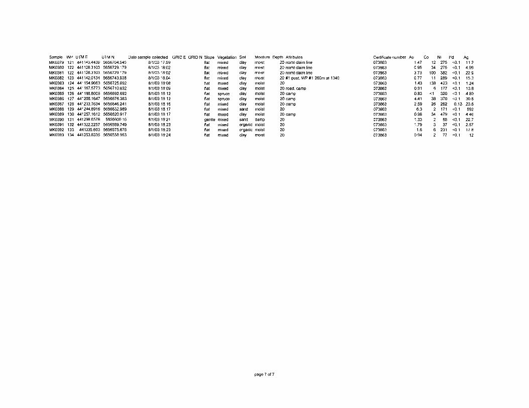
SampleMK0379MK0380MK0381MK0382MK0383MK0384MK0385MK0386MK0387MK0388MK0389MK0390MK0391MK0392MK0393
WP121122122123124125126127128129130131132133134
UTM E441143.44394411283103441128.3103441142.0134441154.9663441167.5773441188.8005441208.1647441233.7634441244.8916441257.1612441298.6578441322.2257441335.603
441353.8335
UTM N Date sample collected GRID E5656704.5455656729.1795656729.1795656743.9385656725.8925656710.8325656692.6925656676.3635656646.2415656632.9895656620.9175656600.16
5656589.7495656575.8755656558.963
8/1/03 17:598/1/0318:028/1/03 18:028/1/03 18:048/1/0318:088/1/0318:098/1/0318:128/1/0318:128/1/03 18:168/1/0318:178/1/0318:178/1/0318:218/1/0318:238/1/0318:238/1/03 18:24
GRID N Slopeflatflatflatflatflatflatflatflatflatflatflatgentleflatflatflat
Vegetation Soilmixedmixedmixedmixedmixedmixedsprucesprucemixedmixedmixedmixedmixedmixedmixed
clayclaydaydaydaydaydaydaydaysanddaysandorganicorganicday
Moisturemoistmoistmoistmoistmoistmoistmoistmoistmoistmoistmoistdampmoistmoistmoist
Depth Attributes20 norht daim line20 norht daim line20 norht daim line20 #1 post, WP#1-260m at 13402020 road, camp20 camp20 camp20 camp2020 camp20202020
Certificate number073863073863073863073863073863073863073863073863073863073863073863073863073863073863073863
Au1.470.953.730.771.430.910.834.412.596.3
0.981.331.791.6
0.94
Co Ni12 27534 275100 38211 289
138 4236 177
*1 32038 37026 2622 171
34 479
Pd
2 883 376 2312 77
Ag 11.2 4.99 229 15.3 1.24 13.8
:0.1 4.89 :0.1 30.8 0.13 23.6
592 4.46 22.7 2.57 17.8 12
eO.1
O.1 cO.1 O.1
page 7 of 7

APPENDIX B
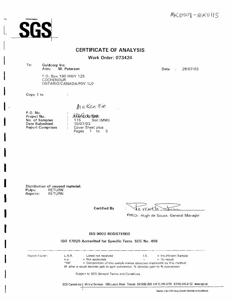
CERTIFICATE OF ANALYSIS
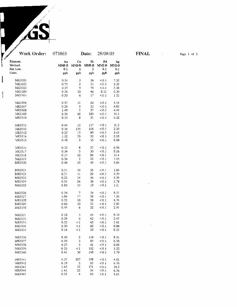
Work Order: 073424
To: Goldcorp Inc.Attn: W. Paterson
P.O. Box 190 HWY 125 COCHENOUR ONTARIO/CANADA/POV 1 LO
Date 28/07/03
Copy 1 to
P.O. No. Project No. No. of Samples Date Submitted Report Comprises
o-
115 Soil (MMI) 10/07/03 Cover Sheet plus Pages 1 to 3
l
l
Distribution of unused material: Pulps: RETURN Rejects: RETURN
Certified By
1 Dr. Hugh de Souza, General Manager
ISO 9002 REGISTERED
ISO 17025 Accredited for Specific Tests. SCC No. 456
Report Footer: L.N.R. = Listed not received l.S. = Insufficient Sample n.a. = Not applicable - = No result *INF = Composition of this sample makes detection impossible by this method M after a result denotes ppb to ppm conversion, "/o denotes ppm to "/o conversion
Subject to SGS General Terms and Conditions
SGSCanada Inc. Mineral Services 1885 Leslie Street Toronto ON M3B2M3 t (416)445-5755 f (416)445-4152 www.sgs.ca
Member of the SGS Group (Societe Generate de Surveillance}

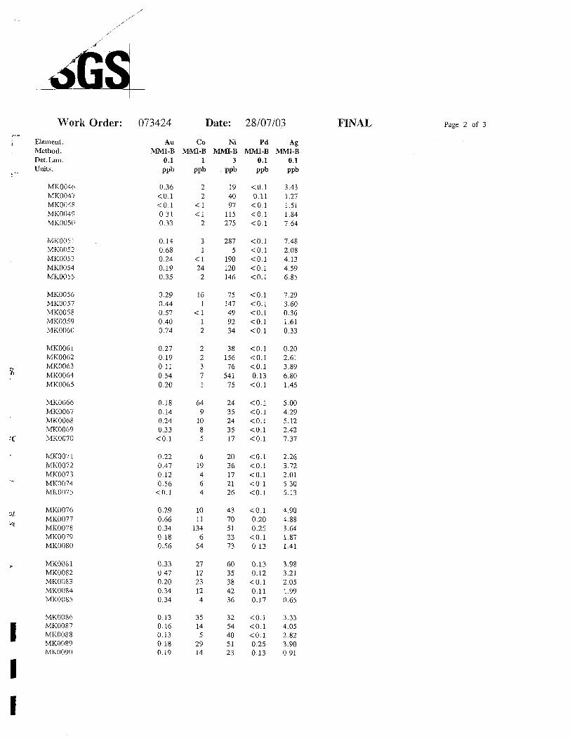
Work Order: 073424 Date: 28/07/03
i
rrrrrrf
-
sa
n
\
\
Element.Method.Det.Lim.Units.
MKOOOJMK0002MK0003MK0004 MK0005
MK0006MK0007 MKOOOS MK0009MK0010
MK0011 MK0012MK0013MK0014 MK0015
MK0016MK0017MK0018 MK0019MK0020
MK0021MK0022MK0023MK0024MK0025
MK0026MK0027MK0028MK0029MK0030
MK0031MK0032MK0033MK0034MK0035
MK0036MK0037MK0038MK0039 MK0040
MK0041MK0042 MK0043MK0044MK0045
AuMMI-B
0.1ppb
0.391.460.861.371.04
2.253.572.001.411.45
0.270.771.700.140.16
0.280.661.050.510.54
0.510.960.114.031.47
0.474.260.670.440.30
0.150.210.140.180.35
0.420.980.410.270.16
0.210.210.270.341.11
CoMMI-B
1ppb
162272
1421
224
1<l
233
4-Ci
392
3
26284
363133
413
2146
245248
543
•CI4
NiMMI-B
3ppb
51384258317531
563552253177306
1001119261
101
401186198215
55
3734137975
2977
128382189
163167283233
2839
7196925
392942
156346
PdMMI-B
0.1ppb
0.15•CO.l•CO.l•cO.l•cO.l
•CO.l•CO.l•CO.l•CO.l•CO.l
•cO.l•CO.l^.1•CO.l^.1
-CO.l^.1^.10.30
•CO.l
•cO.l•CO.l•CO.l•cO.l•cO.l
•cO.l•CO.l•CO.l•cO.l•CO.l
•CO.l•cO.l•CO.l0.11^.1
•CO.l<0.l•CO.l^.1•CO.l
•CO.l^.1•CO.l•cO.l•CO.l
AgMMI-B
0.1ppb
4.6718.14.1817.18.46
19.24.8815.812.019.7
7.006.0617.54.943.00
11.610.211.57.084.83
3.257.271.8214.115.6
2.0214.0(i. 116.698.24
4.439.363.190.312.65
2.002.0712.42.495.36
8.034.154.474.3224.9
FINAL Page l of 3
Work Order: 073424 Date: 28/07/03 FINAL Page 2 of 3
l
l
Element. Method. Det.Lim.Units.
MK0046 MK0047 MK0048 MK0049 MK0050
MK0051 MK0052 MK0053 MK0054 MK0055
MK0056 MK0057 MK0058 MK0059 MK0060
MK0061 MK0062 MK0063 MK0064 MK0065
MK0066 MK0067 MK0068 MK0069 MK0070
MK0071 MK0072 MK0073 MK0074 MK0075
MK0076 MK0077 MK0078 MK0079 MK0080
MK0081 MK0082 MK0083 MK0084 MKOOS5
MK0086 MK0087 MKOOSS MK0089 MK0090
AuMMI-B
0.1ppb
0.36<0.1^.10.310.33
0.140.680.240.190.35
0.290.440.570.400.74
0.270.190.110.540.20
0.180.140.240.33
•CO.l
0.220.470.120.56
•CO.l
0.290.660.340.180.56
0.330.470.200.340.34
0.130.160.130.180.19
CoMMI-B
1ppb
22
<l<l
2
31
•ci24
2
161
"CI12
22371
649
1085
619464
1011
1346
54
271223124
35145
2914
NiMMI-B
3ppb
194097
115275
2875
190120146
75147499234
38156
76541
75
2435243517
2036172126
4370512373
6035384236
3254405123
PdMMI-B
0.1ppb
•CO.l0.11
•CO.l•cO.l•cO.l
•CO.l^.1•cO.l^.1•CO.l
•CO.l•CO.l•cO.l^.1•CO.l
•cO.l•CO.l•cO.l0.13
•CO.l
^.1•CO.l^.1•CO.l•cO.l
•CO.l^.1•CO.l•cO.l•CO.l
"CO.l0.200.25
*:0.10.13
0.130.12^.10.110.17
^.1•CO.l•CO.l0.250.13
AgMMI-B
0.1ppb
3.431.271.511.847.64
7.482.084.134.596.85
7.293.600.361.610.33
0.202.613.896.801.45
5.004.295.122.427.37
2.263.722.015.305.13
4.904.883.641.871.41
3.983.212.051.990.65
3.334.052.823.900.91
l
Work Order: 073424 Date: 28/07/03 FINAL 3 of 3
Element. Method. Det.Lim. Units.
MK0091 MK0092 MK0093 MK0094 MK0095
MK0096 MK0097 MK009S MK0099 MK0100
MK0101 MK0102 MK0103 MK0104 MK0105
MK0106 MK0107 MK010S MK0109 MK0110
MK0111MK0112 MK0113 MK0114 MK0115
*Dup MK0001*Dup MK0013*Dup MK0025*Dup MK0037*Dup MK0049
*Dup MK0061*Dup MK0073*Dup MK0085*Dup MK0097*Dup MK0110
AuMMI-B
0.1ppb
0.250.980.140.240.31
0.430.600.150.10.18
0.240.230.110.282.46
0.290.320.140.50
•CO.l
0.180.270.170.620.88
0.531.761.541.140.34
0.230.200.380.740.1
CoMMI-B
1ppb
136324
59113
444
15272753
2
323413
35
78
394
163
15145
<l
144
1176
NiMMI-B
3ppb
3234384523
2780201218
32142061
7
3932184716
28334634
222
6080743994
3615378817
PdMMI-B
0.1ppb
O.I0.18
•CO.l0.1<0.l
0.130.16
•CO.l•CO.l•CO.l
0.14•CO.l•CO.l0.1O.I
O.IO.IO.I0.1O.I
0.11O.I0.10.110.11
0.11O.IO.IO.IO.I
O.IO.I0.1O.I0.1
AgMMI-B
0.1ppb
2.611.011.902.372.34
3.532.073.336.358.70
5.693.060.855.002.21
1.121.261.412.312.70
4.005.6012.42.229.30
4.5118.814.91.761. 44
0.201.940.721.763.03
L L L L L L L L L l L L l l l l l
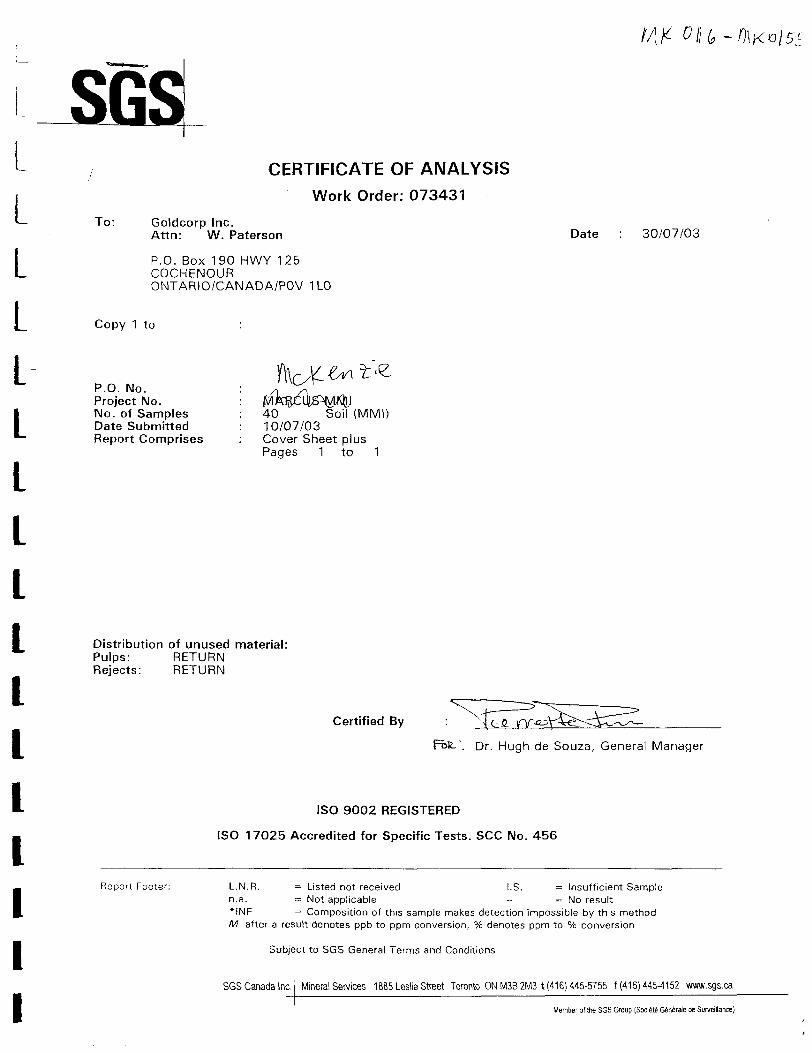
CERTIFICATE OF ANALYSIS
Work Order: 073431
To: Goldcorp Inc.Attn: W. Paterson
P.O. Box 190 HWY 125 COCHENOUR ONTARIO/CANADA/POV 1 LO
Copy 1 to
P.O. No. Project No. No. of Samples Date Submitted Report Comprises
Date 30/07/03
40 Soil (MMI) 10/07/03 Cover Sheet plus Pages 1 to 1
Distribution of unused material: Pulps: RETURN Rejects: RETURN
Certified By
Dr. Hugh de Souza, General Manager
ISO 9002 REGISTERED
ISO 17025 Accredited for Specific Tests. SCC No. 456
Report Footer: L.N.R. = Listed not received l.S. = Insufficient Sample n.a. = Not applicable - s No result *INF = Composition of this sample makes detection impossible by this method M after a result denotes ppb to pprn conversion, Ve denotes ppm to 07o conversion
Subject to SGS General Terms and Conditions
SGS Canada Inc. Mineral Services 1885 Leslie Street Toronto ON MSB 2M3 t (416) 445-5755 f (416)445^152 www.sgs.ca
Member of the SGS Group (Societe Generate de Surveilance)

073431 Date: 30/07/03 FINAL l of l
l
l
L l
MK0116 MK0117 MK0118 MK0119 MK0120
MK0121 MK0122MK0123 MK0124 MK0125
MK0126 MK0127 MK0128 MK0129 MK0130
MK0131 MK0132 MK0133 MK0134 MK0135
MK0136 MK0137 MK0138 MK0139 MK0140
MK0141 MK0142 MK0143 MK0144 MK0145
MK0146 MK0147 MK0148 MK0149 MK0150
MK0151 MK0152 MK0153 MK0154 MK0155
*DupMK0116*Dup MK0128*DupMK0140*Dup MK0152
AuMMI-B
0.1ppb
0.230.750.14
•CO.l0.18
0.650.350.230.120.17
0.52•CO.l0.240.250.19
0.51•CO.l•CO.l0.350.15
•CO.l0.270.230.240.17
0.160.460.310.940.23
0.290.190.130.260.71
•CO.l0.17^.10.450.40
0.170.170.160.25
CoMMI-B
1ppb
817
81522
9122
175
7101177
289
1037
485
124
5112022
3
64
171011
415
82230
911
516
NiMMI-B
3ppb
2238132242
4844223524
2315212719
3916321727
7026572412
3940247920
2014313866
3147142164
21221143
PdMMI-B
0.1ppb
0.11'CO.l^.10.180.13
0.13•CO.l•CO.l0.11
•CO.l
0.16•CO.l*:0.10.270.17
0.13•CO.l0.110.160.11
•CO.l•CO.l0.11
•CO.l•CO.l
0.160.150.220.280.14
0.15•CO.l0.120.110.36
•CO.l•CO.l•CO.l•CO.l0.41
0.12^.10.12
•CO.l
AgMMI-B
0.1ppb
3.401.501.411.837.75
3.7810.710.815.75.10
2.421.469.833.542.03
4.494.833.562.582.99
8.358.968.983.662.02
3.333.071.565.071.62
1.001.013.793.365.51
0.512.050.691.629.56
2.988.801.682.01
1 1 l l l1
CERTIFICATE OF ANALYSIS
Work Order: 073862
To: Goldcorp Inc.Attn: W. Paterson
P.O. Box 190 HWY 125 COCHENOUR ONTARIO/CANADA/POV 1 LO
Copy 1 to
Date 28/08/03
r r r r r r r r r r r
P.O. No. Project No. No. of Samples Date Submitted Report Comprises
McKenzie107 Soil (MM!)11 /08/03Cover Sheet plusPages 1 to 3
Distribution of unused material: Pulps: RETURN Rejects: RETURN
Certified By
Dr. Hugh de Souza, General Manager
ISO 9002 REGISTERED
ISO 17025 Accredited for Specific Tests. SCC No. 456
Report Footer:
SGS Canada Inc.
L.N.R. = Listed not received l.S. = Insufficient Sample n.a. = Not applicable -- = No result *INF = Composition of this sample makes detection impossible by this method M after a result denotes ppb to ppm conversion, Vo denotes ppm to "/o conversion
Subject to SGS General Terms and Conditions
Minerals Services 1885 Leslie Street Toronto ON MSB 2M3 t (416) 445-5755 f (416) 445-4152 www.sgs.ca
Member of the SGS Group (Sociele Generals de Surveillance)
Work Order: 073862 Date: 28/08/03 FINAL l of 3
l
Element. Method. Det.Lira. Units.
MK0156 MK0157 MK0158 MK0159 MK0160
MK0161 MK0162 MK0163 MK0164 MK0165
MK0166 MK0167 MK0168 MK0169 MK0170
MK0171 MK0172 MK0173 MK0174 MK0175
MK0176 MK0177 MK0178 MK0179 MK0180
MK0181 MK0182 MK0183 MK0184 MK0185
MK0186 MK0187 MK0188 MK0189 MK0190
MK0191 MK0192 MK0193 MK0194 MK0195
MK0196 MK0197 MK0198 MK0199 MK0200
AuMMI-B
0.1ppb
0.310.280.340.880.15
0.130.110.190.340.12
0.23<0.1•CO.l•CO.l^.1
0.130.330.120.162.09
0.130.16
•CO.l0.150.15
0.270.100.240.120.55
0.600.550.180.180.17
2.260.200.325.670.15
^.1'CO.l0.240.550.39
CoMMI-B
1ppb
8719246321
1421173610
43238
1056
316
57
1425
679
109
13210169
461
741
4
55114
1284
66871
NiMMI-B
3ppb
3724
5319523
1621561420
13676
12
3742361844
3964262522
201821
27888
2256152515
883838
17260
262616430
PdMMI-B
0.1ppb
•cO.l•cO.l0.110.260.17
0.100.120.13
•CO.l^.1
"CO.l*C0.1^.1•cO.l0.13
•CO.l0.13
•CO.l0.110.16
0.130.290.120.240.10
0.11•CO.l•cO.l•cO.l0.26
^.10.16
•CO.l•CO.l0.10
0.250.110.17
•CO.l•CO.l
^.1•CO.l0.11
•CO.l•CO.l
AgMMI-B
0.1ppb
0.660.753.961.140.79
0.500.582.910.271.72
0.160.10^.1c: 0.10.25
2.271.721.602.810.49
0.213.640.550.590.75
0.590.360.540.221.84
4.030.760.351.223.22
1.761.481.497.823.09
7.3312.10.385.521.84
Work Order: 073862 Date: 28/08/03 FINAL Page 2 of 3Fr r r r r r r r r r r r r r i i
Element. Method. Det.Lim.Units.
MK0201 MK0202 MK0203 MK0204 MK0205
MK0206 MK0207 MK0208 MK0209 MK0210
MK0211 MK0250 MK0251 MK0252 MK0253
MK0254 MK0255 MK0256 MK0257 MK0258
MK0259 MK0260 MK0261 MK0262 MK0263
MK0264 MK0265 MK0266 MK0267 MK0268
MK0269 MK0270 MK0271 MK0272 MK0273
MK0274 MK0275 MK0276 MK0277 MK0278
MK0279 MK0280 MK0281 MK0282 MK0283
AuMMI-B
0.1ppb
0.150.19^.1<0.10.11
0.160.120.221.13
•CO.l
<0.10.140.420.310.12
0.280.130.280.120.54
0.310.180.470.270.84
0.290.280.790.180.32
0.29•CO.l^.1•CO.l0.22
•CO.l2.36
•CO.l<0.1^.1
0.120.580.850.380.11
CoMMI-B
1ppb
2327
43
10
11117
708
111
1755
233
95
1764
635
13935
8
181747
13
7612
22
23
86598
72019106
NiMMI-B
3ppb
3728141427
2234335420
2103973
163
432320
943
10129652320
1624
78
31
582527
824
353879
915
13102382423
PdMMI-B
0.1ppb
^.1^.1^.1^.1•CO.l
^.1•CO.l•CO.l0.110.14
0.23•CO.l^.1•CO.l0.15
0.13•CO.l•CO.l•CO.l^.1
•CO.l0.110.18
•CO.I•CO.l
0.150.16^.1•cO.l0.13
•CO.l0.10
•CO.l^.10.13
^.10.11^.1•CO.l0.10
^.1^.10.14
•CO.l•CO.l
AgMMI-B
0.1ppb
6.744.800.560.363.64
3.314.923.552.000.99
0.221.930.782.753.40
3.212.260.670.152.02
6.363.220.680.620.23
0.25•CO.l-C 0.1•CO.l2.32
2.960.420.250.14
•CO.l
1.010.180.580.142.49
1.513.830.670.512.94

Work Order: 073862 Date: 28/08/03 FINAL Page 3 of 3
Element. Method. Det.Lim. Units.
MK0284 MK0285 MK0286 MK0287 MK028S
MK0289 MK0290 MK0291 MK0292 MK0293
MK0294 MK0295 MK029(i MK0297 MK0298
MK0299 MK0300*Dup MK0156*Dup MK0168*Dup MK0180
*Dup MK0192*Dup MK0204*Dup MK0254*Dup MK0266*Dup MK0278
*Dup MK0290
AuMMI-B
0.1ppb
0.300.210.251.700.18
0.710.631.700.840.24
0.10CO.l0.560.110.17
CO.l0.180.25
CO.lCO.l
0.10CO.l0.520.820.12
0.47
CoMMI-B
1ppb
171217
54
1312182315
638
354
121
10027
143
1048
11
NiMMI-B
3ppb
1443496133
1924983322
149
353338
29C341
519
4012471016
20
PdMMI-B
0.1ppb
CO.l0.14
CO.l0.16
CO.l
0.12CO.l0.28
CO.lCO.l
CO.lCO.lCO.lCO.lCO.l
CO.lCO.l0.15
CO.lCO.l
CO.lCO.l0.12
•CO.lCO.l
0.11
AgMMI-B
0.1ppb
0.431.165.481.844.52
0.340.571.194.843.19
0.16CO.l0.192.6512.8
3.661.840.69cO.l0.46
1.770.213.13
CO.l2.74
0.68
ll1
K.
CERTIFICATE OF ANALYSIS
Work Order: 073863
To: Goldcorp Inc.Attn: W. Paterson
P.O. Box 190 HWY 125 COCHENOUR ONTARIO/CANADA/POV 1 LO
Date 28/08/03
r r r r r r r r r
Copy 1 to
P.O. No. Project No. No. of Samples Date Submitted Report Comprises
McKenzie93 Soil (MMI)11/08/03Cover Sheet plusPages 1 to 3
Distribution of unused material: Pulps: RETURN Rejects: RETURN
Certified By
Fbtt. Dr. Hugh de Souza, General Manager
ISO 9002 REGISTERED
ISO 17025 Accredited for Specific Tests. SCC No. 456
Report Footer:
SGS Canada Inc.
L.N.R. s Listed not received l.S. = Insufficient Sample n.a. = Not applicable -- = No result *INF = Composition of this sample makes detection impossible by this method M after a result denotes ppb to ppm conversion, 96 denotes ppm to "/o conversion
Subject to SGS General Terms and Conditions
Minerals Services 1885 Leslie Street Toronto ON M3B 2M3 t (416) 445-5755 f (416) 445-4152 www.sgs.ca
Member of the SGS Group (Societe Generate de Surveillance)
Work Order: 073863 Date: 28/08/03Element. Method. Det.Lim.Units.
MK0301 MK0302 MK0303 MK0304 MK0305
MK0306 MK0307 MK0308 MK0309 MK0310
MK0311 MK0312 MK0313 MK0314 MK0315
MK0316 MK0317 MK0318 MK0319 MK0320
MK0321 MK0322 MK0323 MK0324 MK0325
MK0326 MK0327 MK0328 MK0329 MK0330
MK0331 MK0332 MK0333 MK0334 MK0335
MK0336 MK0337 MK0338 MK0339 MK0340
MK0341 MK0342 MK0343 MK0344 MK0345
AuMMI-B
0.1ppb
0.340.730.170.360.20
0.370.201.490.260.13
0.450.340.251.320.48
0.120.340.170.340.40
0.510.310.230.510.85
0.341.040.320.660.43
0.180.290.520.300.14
0.400.330.270.230.41
0.270.191.451.410.53
CoMMI-B
1ppb
329
206
1155
608
12135
15555
85
162
25
1011142413
71710106
36
•ciOO
233
<l36
2072
25254
NiMMI-B
3ppb
2631744617
242237
22031
117216
805315
2730842243
3529463819
3456282222
4462656020
1108341
152148
33895
1715465
PdMMI-B
0.1ppb
•CO.l•CO.l•cO.l0.11
•CO.l
^.1•cO.l•CO.l•CO.l^.1
^.1•cO.l•cO.l•cO.l^.1
^.1*c0.1•cO.l•CO.l^.1
•CO.l•CO.l•CO.l•CO.l•CO.l
•CO.l•CO.l^.1^.1^.1
'CO.l•CO.l•cO.l^.1cO.l
•cO.l•CO.l•CO.l•CO.l•CO.l
^.1•CO.l•CO.l•CO.l•cO.l
AgMMI-B
0.1ppb
7.323.325.580.301.22
5.194.024.4910.16.02
10.22.203.655.550.88
6.988.2611.41.033.84
1.8.55.295.392.781.21
9.191.264.762.842.91
0.142.471.010.860.25
8.316.380.825.221.79
4.616.7614.36.263.65
FINAL Page l of 3

Work Order: 073863 Date: 28/08/03 FINAL Page 2 of 3
Element. Method. Det.Lim.Units.
MK0346 MK0347 MK0348 MK0349 MK0350
MK0351 MK0352 MK0353 MK0354 MK0355
MK0356 MK0357 MK0358 MK0359 MK0360
MK0361 MK0362 MK0363 MK0364 MK0365
MK0366 MK0367 MK0368 MK0369 MK0370
MK0371 MK0372 MK0373 MK0374 MK0375
MK0376 MK0377 MK0378 MK0379 MK0380
MK0381 MK0382 MK0383 MK0384 MK0385
MK0386 MK0387 MK0388 MK0389 MK0390
AuMMI-B
0.1ppb
2.272.891.050.500.44
0.15•CO.l0.11
<0.10.13
0.200.200.390.15
•C0.1
<0.1<0.10.150.131.57
0.140.400.40
'CO.l0.63
0.690.110.120.470.54
1.210.281.691.470.95
3.730.771.430.910.83
4.412.596.300.981.33
CoMMI-B
1ppb
47
11206
1
89
11112
1113773
34
1845
594
1818
10692
42
419
1234
10011
1386
<l
3826
234
2
NiMMI-B
3ppb
405440242
27O
1915217825
251524205
38
424327
4335283847
20133
126271
76146300275275
382289423177320
370262171479
88
PdMMI-B
0.1ppb
•co.i'co.i•CO.l0.12
'CO.l
'CO.l•co.i0.14
*:0.1<0.1
-CO.l'CO.l•cO.l<OA•CO.l•CO.l•CO.l•CO.l•cO.l•CO.l
•cO.l•CO.l'CO.l•CO.l•CO.l
•CO.l^.1•CO.l•cO-10.11
^.1•CO.l•CO.l•CO.l<0.l
<G.l'CO.l•CO.l•CO.l•CO.l
•cO.l0.13
•CO.l'CO.l'CO.l
AgMMI-B
0.1ppb
15.556.314.00.381.86
4.492.961.389.769.23
3.080.551.280.490.13
0.11•CO.l12.43.541.36
5.275.041.423.955.79
0.782.090.490.851.37
3.910.967.9711.24.99
22.915.31.2413.84.89
30.823.6592
4.4622.7
Work Order: 073863 Date: 28/08/03 FINAL 3 of 3
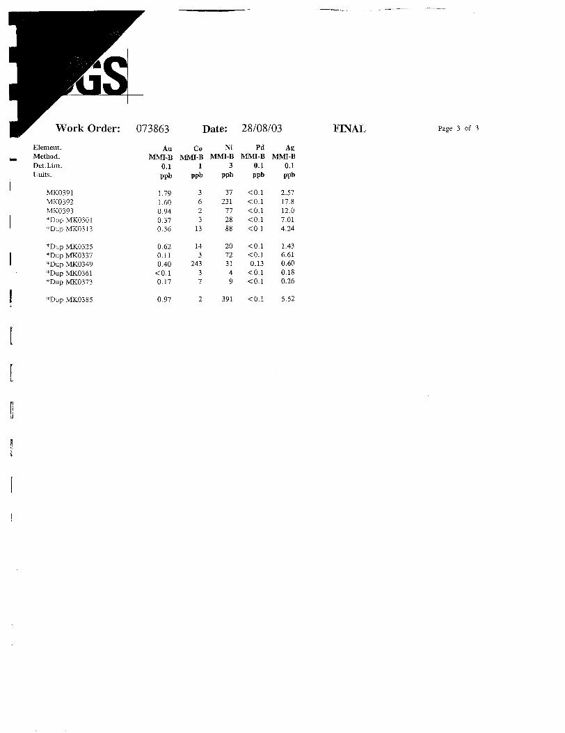
Element. Method. Det.Lim.Units.
MK0391 MK0392 MK0393*Dup MK0301*Dup MK0313
'"Dup MK0325*Dup MK0337*Dup MK0349*Dup MK0361*Dup MK0373
AuMMI-B
0.1ppb
1.791.600.940.370.36
0.620.110.40
•CO.l0.17
CoMMI-B
1ppb
3623
13
143
24337
NiMMI-B
3ppb
37231
772888
20723149
PdMMI-B
0.1ppb
^.1*:0.1^.1^.1^.1
<0.l"CO.l0.13
<0.1<0.1
AgMMI-B
0.1ppb
2.5717.812.07.014.24
1.436.610.600.180.26
*Dup MK0385 0.97 391 •CO.l 5.52
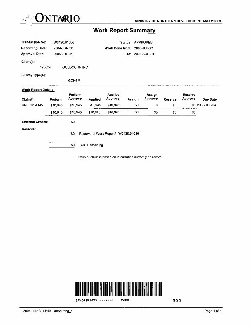
rf v ONTARIO MINISTRY OF NORTHERN DEVELOPMENT AND MINES
Transaction No:
Recording Date:
Approval Date:
Client(s):
125824
Survey Type(s):
W0420.01036
2004-JUN-30
2004-JUL-06
Work Report Summary
Status: APPROVED
Work Done from: 2003-JUL-27
to: 2003-AUG-01
GOLDCORP INC.
GCHEM
Work Report Details:
Claim* Perform
KRL 1234145 310,945
310,945
External Credits:
Reserve:
Perform Approve
310,945
310,945
SO
Applied Applied Approve
810,945 310,945
310,945 310,945
Assign
30
30
Assign Approve
0
SO
Reserve Reserve Approve
so soso so
Due Date
2008-JUL-04
30 Reserve of Work Report*: W0420.01036
SO Total Remaining
Status of claim is based on information currently on record.
52N04SW2073 2.27998 DOME 900
2004-Jul-13 14:40 armstrong-d Page 1 of 1
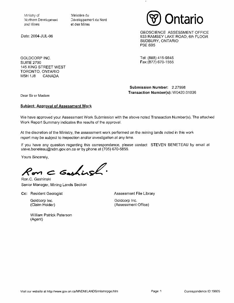
Ministry ofNorthern Developmentand Mines
Date: 2004-JUL-06
Ministere du Developpement du Nord et des Mines Ontario
GEOSCIENCE ASSESSMENT OFFICE 933 RAMSEY LAKE ROAD, 6th FLOOR SUDBURY, ONTARIO P3E 6B5
GOLDCORP INC. SUITE 2700145 KING STREET WEST TORONTO, ONTARIO M5H 1J8 CANADA
Tel: (888) 415-9845 Fax:(877)670-1555
Dear Sir or Madam
Submission Number: 2.27998 Transaction Number(s): W0420.01036
Subject: Approval of Assessment Work
We have approved your Assessment Work Submission with the above noted Transaction Number(s). The attached Work Report Summary indicates the results of the approval.
At the discretion of the Ministry, the assessment work performed on the mining lands noted in this work report may be subject to inspection and/or investigation at any time.
If you have any question regarding this correspondence, please contact STEVEN BENETEAU by email at [email protected] or by phone at (705) 670-5855.
Yours Sincerely,
/P-Ron.C. Gashinski
Senior Manager, Mining Lands Section
Cc: Resident Geologist
Goldcorp Inc. (Claim Holder)
Assessment File Library
Goldcorp Inc. (Assessment Office)
William Patrick Paterson (Agent)
Visit our website at http://www.gov.on.ca/MNDM/LANDS/mlsmnpge.htm Page: 1 Correspondence 10:19605
CANADA raovmeMU.Hmm V.ANAUA
Mining Land Tenure Map
o o
I
o
4390QOE 440000E 441000E 442000E i'
General Information and Limitations*tiNrta MMnkn RHWnjciBHrninoiAUixtiuKivnriirw Pt o vmctti
nuy akv lw ebtoinwl (hw\t)h Ih* t**l Land Ttitei
irtoi*' Pfllcn d (ho MrtOt/j w M
( itw MiniKrv el W
Date l Time of Issue: Tue Jul 13 14:42:50 EOT 2004
TOWNSHIP ; AREA PLAN DOME G-3748
ADMINISTRATIVE DISTRICTS l DIVISIONS
Mining Division Red LakeLand Titles/Registry Division KENORAMinistry of Natural Resources District RED LAKE
TOPOGRAPHIC Land Tenure
f WMWU Patxm
tt*f*k)MfMtofi(
LB|IS
,,,,,,. W'
....... twwM*c**Nwwi*
f7"l ^JM|"' ̂ **B*e*Bti
r|"| S.i(Mi*rtnU Mf.*fOW
L . w -t*- *
LAND TENURE WITHDRAWALS
IMPORTANT NOTICES
LAND TENURE WITHDRAWAL DESCRIPTIONS
CMOS KB Worn
24S Ws Jwn
lo, i Cio J c* Mnf*" Wi0-.j.'uw*.n-eirn*Wm,uwuMi-c*,'a*l(™'0 .CfcC*)lm..Vt*wn
to. joan KB nw)B'' Mt c*ntti,vw*m
SOW 18MT4MAr4,n SUWAOS ItHQMTS OMT )WO lS5*MAVi(S,2ftWBURrACE WCHTS ONLY
, 2(KH M.* B. (W*. P3|tH.(l. 2iXe CtMCTEflV - SUOvMStrT tO SECTION M MINING ACT HSD IHSa E, two 9**. 3 rf f, LA, O*i 15, HBO'J-n.O. Wi(t*iF*Bn(oflh*PunK**ot(in)iMN(vs lh
Wfl Di* 18, t
sw is wo-s*
2.27998 GCHEM
Tat: l WU 1 4t HUMSMtp fetiien NAD a t
4*^.^115": UTM P *"B"M" l Tn*Tflmi*iln hum fliwKMi 1 (n


